IP32 7FQ - Trade counter for sale in SP77, Suffolk Park, Lady Miriam W…
View on Property Piper
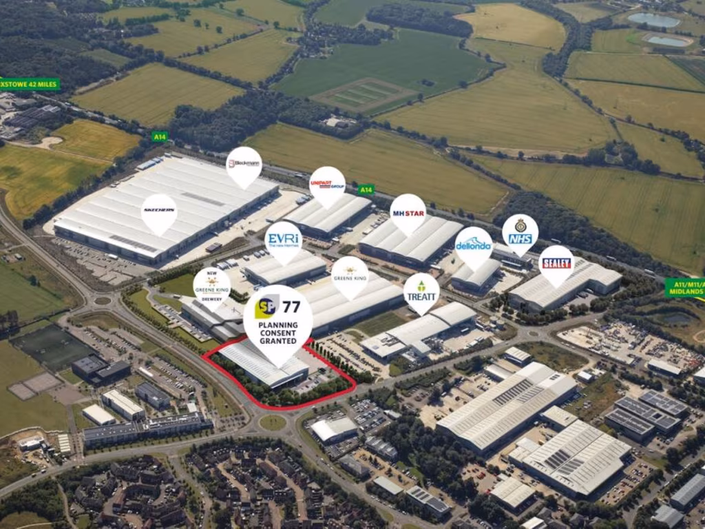
Trade counter for sale in SP77, Suffolk Park, Lady Miriam Way, Bury St Edmunds, IP32 7FQ, IP32
Property Details
- Price: £1
- Bedrooms: 1
- Bathrooms: 1
- Property Type: undefined
- Property SubType: undefined
Brochure Descriptions
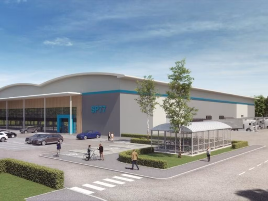
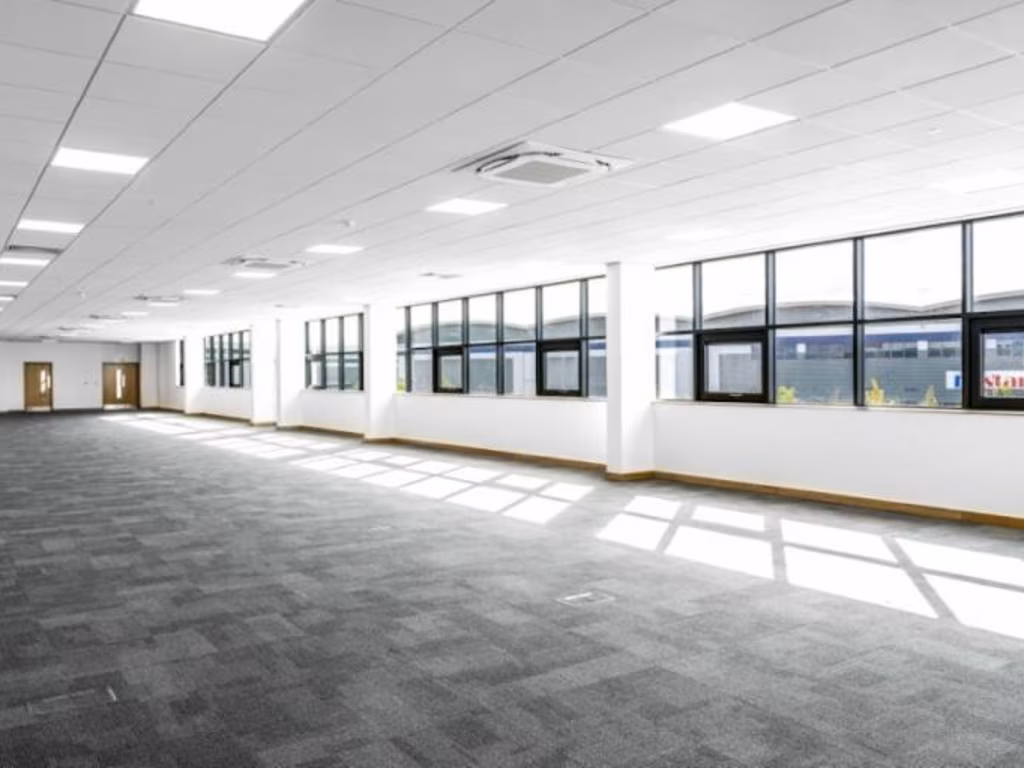
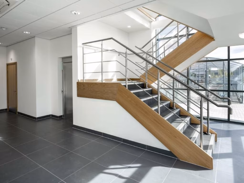
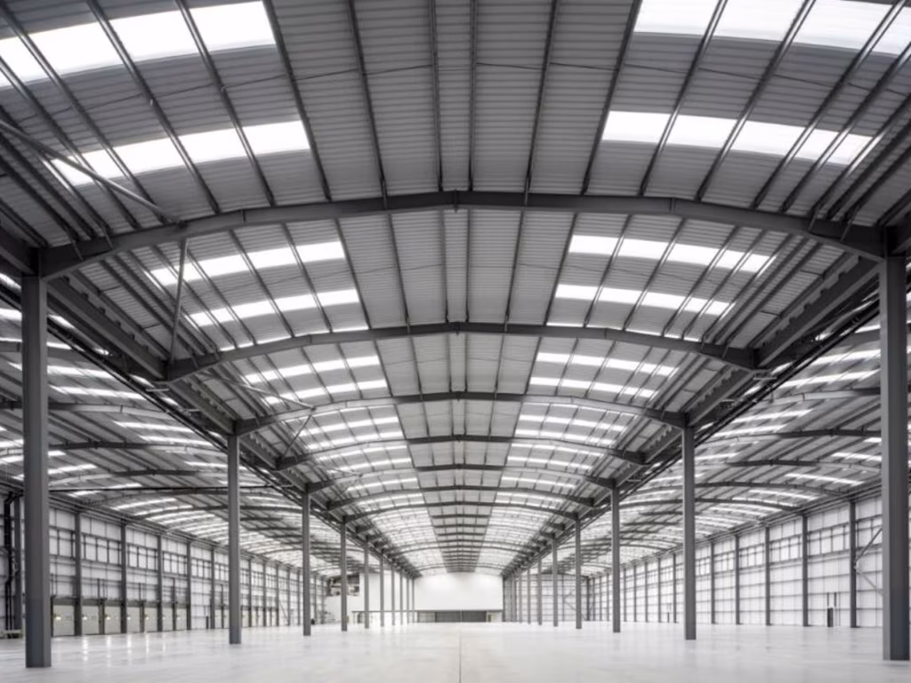
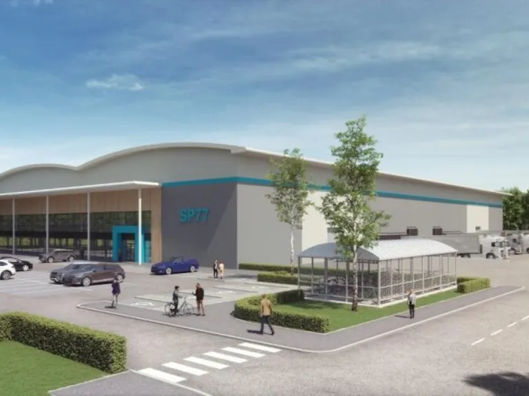
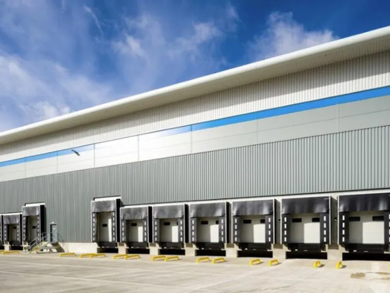
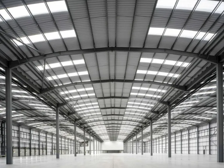
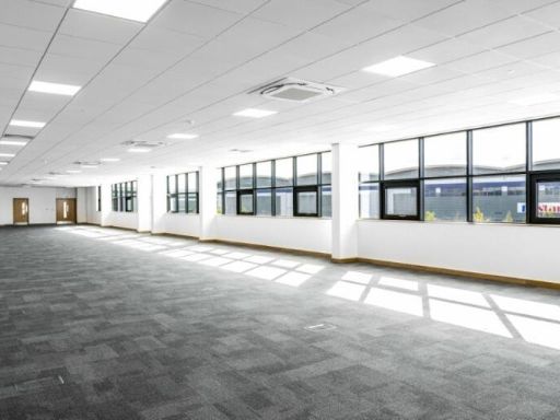
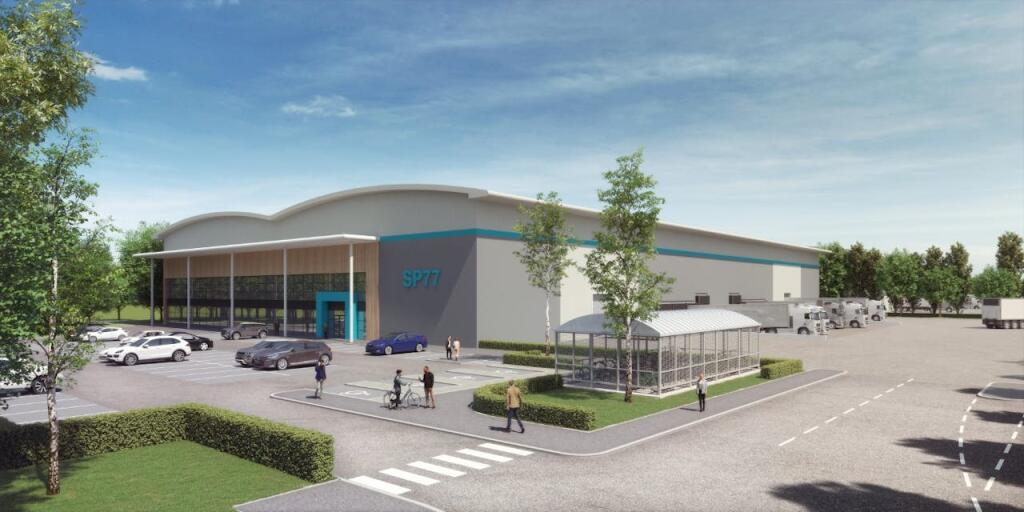
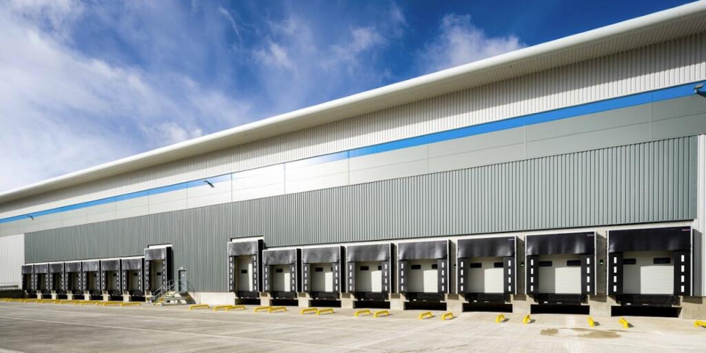
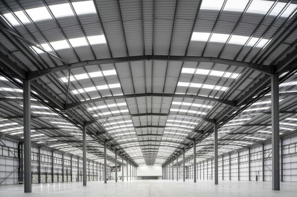
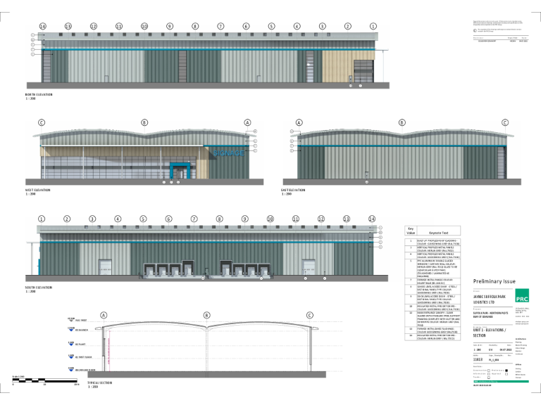
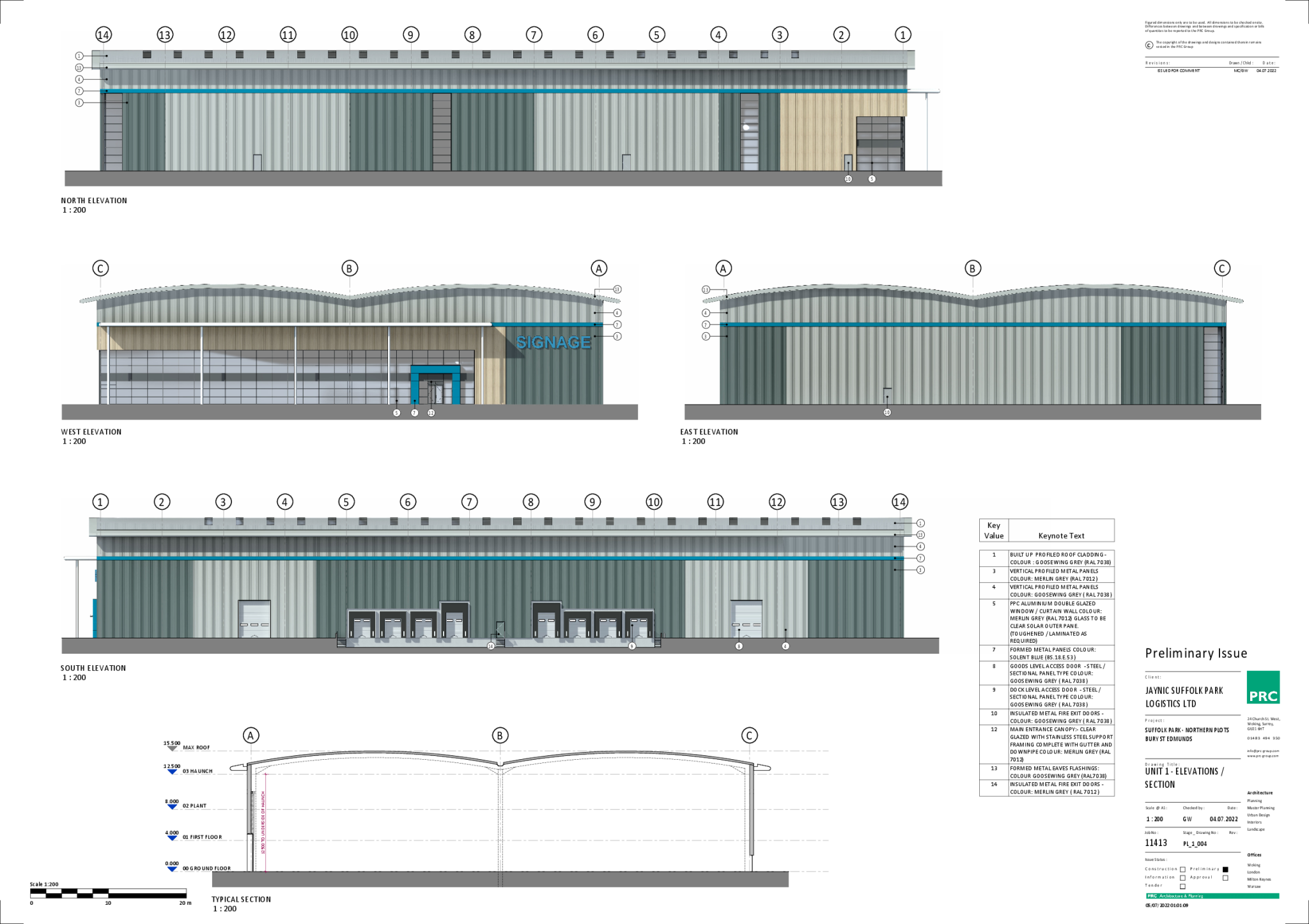
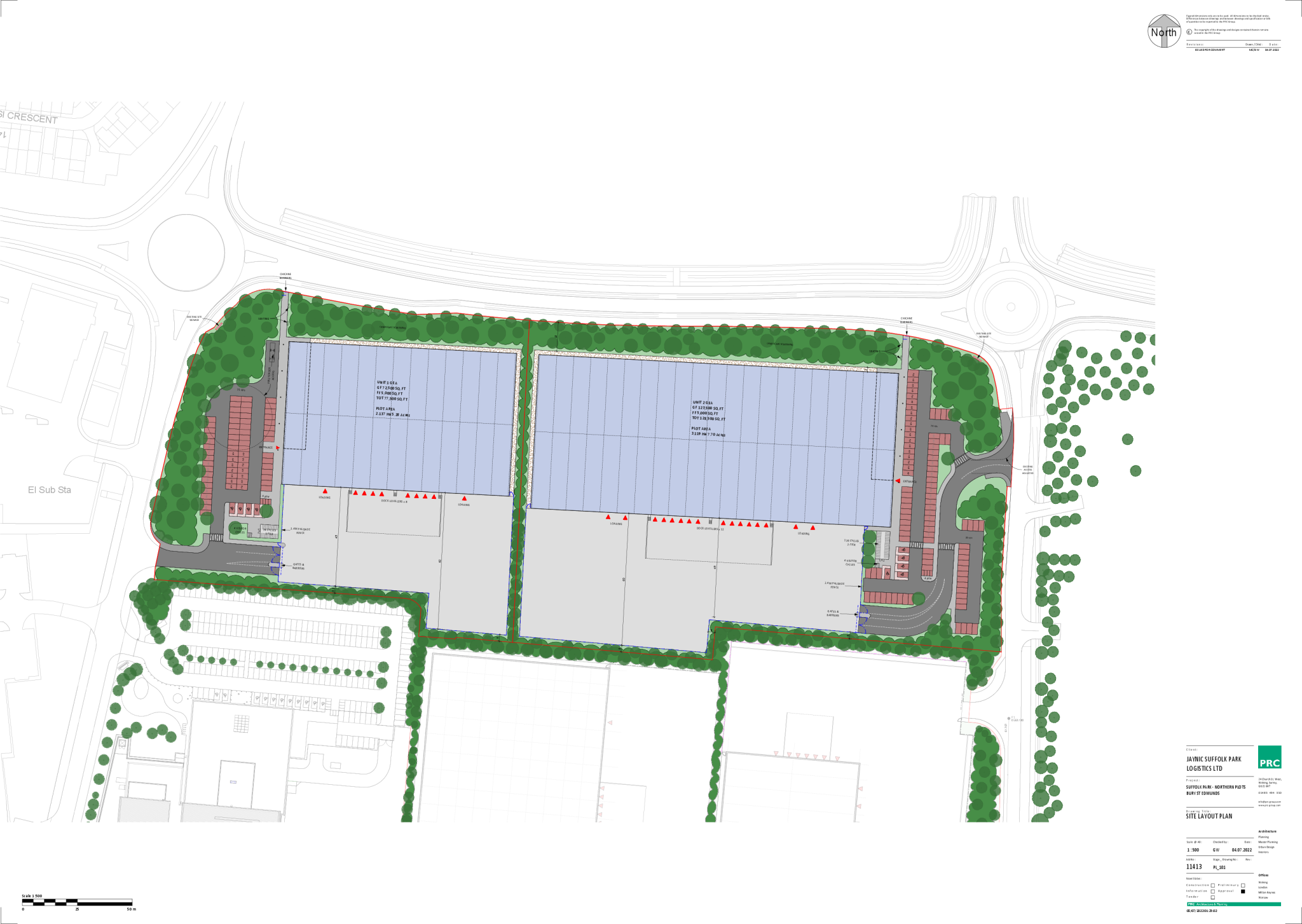
- The property for sale appears to be a large warehouse unit in the final phase of development. It is situated within the Suffolk Park logistics destination, a strategic location renowned for its logistics capabilities. The modern warehouse features extensive parking facilities and easy access for large delivery vehicles, making it highly suitable for logistics and distribution purposes. The building's exterior is contemporary with a large, inviting facade. The surrounding environment is well-maintained with some landscaping and ample space for vehicle maneuvering indicating a spacious design optimal for business operations.
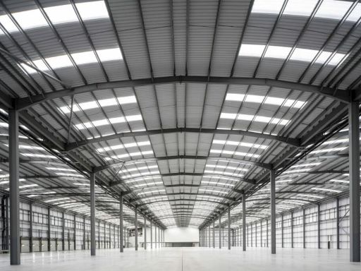
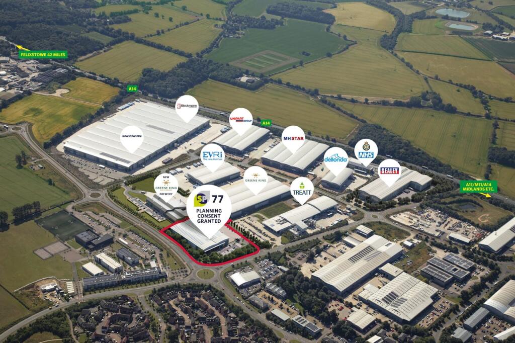
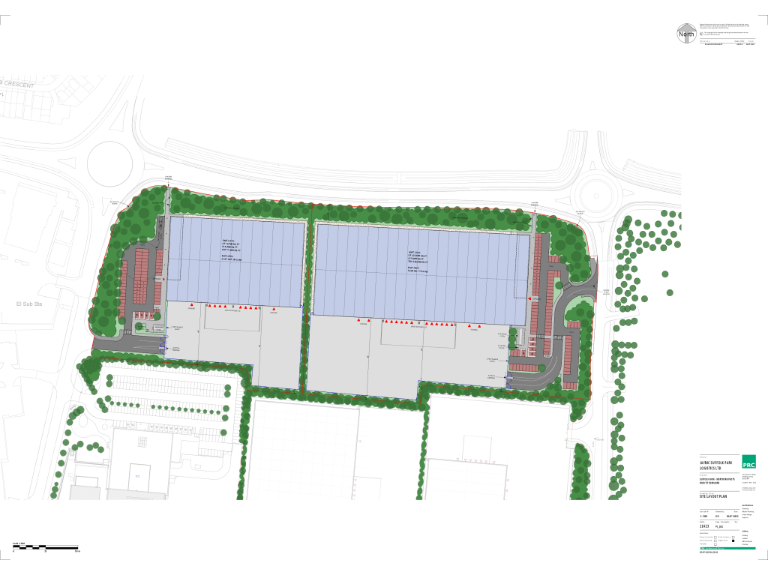
- The property appears to be an industrial or commercial unit set within a large business park. The unit is part of a complex with several similar buildings, indicating a primary commercial or distribution hub. Surrounding the unit are expansive open fields, contributing to a semi-rural feel despite the industrial nature of the park. The proximity to major routes such as the A14 provides excellent logistical connections.
Image Descriptions
- industrial facility modern commercial
- commercial warehouse modern industrial
Floorplan Description
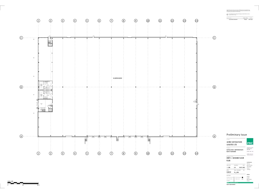
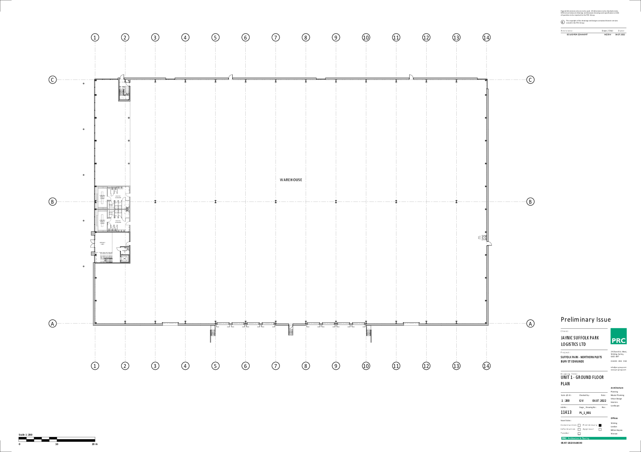
- An industrial logistics building located in Suffolk Biz Park.
Textual Property Features
Detected Visual Features
- industrial
- commercial
- modern
- facility
- high ceiling
- large space
- parking
- warehouse
- manufacturing
- logistics
- loading docks
- modern build
- distribution
Nearby Schools
- Abbots Green Primary Academy
- Thurston Church of England Primary Academy
- Howard Community Academy
- Great Barton Church of England Primary Academy
- Set Ixworth School
- Sebert Wood Community Primary School
- Sybil Andrews Academy
- Ixworth Church of England Primary School
- Culford School
- Rougham Church of England Primary School
- Hardwick Primary School
- Guildhall Feoffment Community Primary School
- Thurston Community College
- Bury St Edmunds County High School
- Great Whelnetham Church of England Primary School
- Ickworth Park Primary School
- South Lee School
- Westgate Community Primary School and Nursery
- St Edmund's Catholic Primary School
- King Edward VI CEVC School
- St Benedict's Catholic School
- Tollgate Primary School
Nearest General Shops
- Id: 327032984
- Tags:
- Building: yes
- Name: Pets Place
- Shop: pet
- Source: Bing
- Website: http://www.moretonhallvets.co.uk/
- TagsNormalized:
- Lat: 52.2403463
- Lon: 0.748187
- FullGeoHash: u1291n0f442s
- PartitionGeoHash: u129
- Images:
- FoodStandards: null
- Distance: 770.3
,- Id: 5223846121
- Tags:
- Addr:
- Postcode: IP32 7AR
- Street: Kempson Way
- Brand: Honda
- Brand:wikidata: Q9584
- Brand:wikipedia: en:Honda
- Name: John Banks Group, Honda
- Operator: John Banks Group
- Shop: car
- Website: https://www.johnbanks.co.uk/
- TagsNormalized:
- Lat: 52.2428609
- Lon: 0.7503901
- FullGeoHash: u1291nd2tr5k
- PartitionGeoHash: u129
- Images:
- FoodStandards: null
- Distance: 677.7
,- Id: 358796136
- Tags:
- Addr:
- Brand: Audi
- Brand:wikidata: Q23317
- Brand:wikipedia: en:Audi
- Building: yes
- Name: Audi
- Shop: car
- Source: Bing
- TagsNormalized:
- Lat: 52.2426507
- Lon: 0.7563712
- FullGeoHash: u1291nqz2xzn
- PartitionGeoHash: u129
- Images:
- FoodStandards: null
- Distance: 328.1
}
Nearest Religious buildings
- Id: 182527421
- Tags:
- Amenity: place_of_worship
- Building: church
- Denomination: anglican
- Name: The Church of the Holy Innocents
- Religion: christian
- Wikidata: Q17526958
- TagsNormalized:
- place of worship
- church
- anglican
- christian
- Lat: 52.2600723
- Lon: 0.7678391
- FullGeoHash: u12933xhgzw6
- PartitionGeoHash: u129
- Images:
- FoodStandards: null
- Distance: 2259.3
,- Id: 357239715
- Tags:
- Amenity: place_of_worship
- Denomination: mormon
- Name: The Church of Jesus Christ of Latter-day Saints
- Religion: christian
- TagsNormalized:
- place of worship
- mormon
- church
- christian
- Lat: 52.2410739
- Lon: 0.731476
- FullGeoHash: u1290whwkdh0
- PartitionGeoHash: u129
- Images:
- FoodStandards: null
- Distance: 1909.6
,- Id: 182529774
- Tags:
- Addr:
- Postcode: IP32 7EW
- Street: Lawson Place
- Amenity: place_of_worship
- Building: yes
- Denomination: anglican,
- Email: worship@ccmh.org.uk
- Name: Christ Church Moreton Hall
- Note: multi-denominational
- Phone: +44 1284 725391
- Religion: christian
- Service_times: 10.30am
- Url: http://www.ccmh.org.uk/
- Website: https://www.ccmh.org.uk
- Wikidata: Q105078520
- TagsNormalized:
- place of worship
- anglican
- church
- christian
- Lat: 52.2445122
- Lon: 0.7417849
- FullGeoHash: u1290yu4kffy
- PartitionGeoHash: u129
- Images:
- FoodStandards: null
- Distance: 1289.7
}
Nearest Medical buildings
- Id: 289545463
- Tags:
- Created_by: JOSM
- Leisure: sports_centre
- Name: Moreton Hall Health Club
- Sport: multi
- TagsNormalized:
- sports
- sports centre
- leisure
- health
- club
- Lat: 52.2471456
- Lon: 0.7370163
- FullGeoHash: u1290z29ttz5
- PartitionGeoHash: u129
- Images:
- FoodStandards: null
- Distance: 1704.4
,- Id: 6875484481
- Tags:
- Amenity: pharmacy
- Brand: Lloyds Pharmacy
- Brand:wikidata: Q6662870
- Brand:wikipedia: en:LloydsPharmacy
- Fixme: Find precise location within the store
- Healthcare: pharmacy
- Name: Lloyds Pharmacy
- TagsNormalized:
- pharmacy
- lloyds pharmacy
- health
- healthcare
- Lat: 52.2394954
- Lon: 0.7376665
- FullGeoHash: u1290vcjhgu0
- PartitionGeoHash: u129
- Images:
- FoodStandards: null
- Distance: 1490.1
,- Id: 358787606
- Tags:
- Addr:
- City: Bury St Edmunds
- Postcode: IP32 7EW
- Street: Lawson Place
- Amenity: doctors
- Building: yes
- Healthcare: doctor
- Name: Mount Farm Surgery
- Source: Bing
- Url: http://www.mountfarm.com/
- TagsNormalized:
- doctor
- doctors
- health
- healthcare
- farm
- surgery
- Lat: 52.2450472
- Lon: 0.7419721
- FullGeoHash: u1290yum3nwm
- PartitionGeoHash: u129
- Images:
- FoodStandards: null
- Distance: 1300.2
,- Id: 6292775975
- Tags:
- Addr:
- City: Bury St Edmunds
- Housename: Mount Farm Surgery
- Postcode: IP32 7EW
- Street: Lawson Place
- Amenity: pharmacy
- Fixme: Find precise location in surgery building
- Name: Croasdales Pharmacy
- Url: http://www.croasdalespharmacy.com/
- TagsNormalized:
- Lat: 52.2450154
- Lon: 0.7422987
- FullGeoHash: u1290yut2bf0
- PartitionGeoHash: u129
- Images:
- FoodStandards: null
- Distance: 1278.4
}
Nearest Leisure Facilities
- Id: 9770582910
- Tags:
- Leisure: fitness_centre
- Level: 0
- Name: Revolution Fitness
- Website: https://rev-fitness.co.uk/
- TagsNormalized:
- fitness
- fitness centre
- leisure
- Lat: 52.2410295
- Lon: 0.7511687
- FullGeoHash: u1291n4yp3xz
- PartitionGeoHash: u129
- Images:
- FoodStandards: null
- Distance: 571.5
,- Id: 9770582909
- Tags:
- Leisure: fitness_centre
- Level: 1
- Name: Bluewave Martial Arts
- Sport: martial_arts
- Website: https://www.bluewavemartialarts.co.uk/
- TagsNormalized:
- fitness
- fitness centre
- leisure
- martial
- martial arts
- sports
- Lat: 52.2409819
- Lon: 0.7511875
- FullGeoHash: u1291n4vzbvg
- PartitionGeoHash: u129
- Images:
- FoodStandards: null
- Distance: 569.6
,- Id: 809909496
- Tags:
- TagsNormalized:
- Lat: 52.244272
- Lon: 0.7610312
- FullGeoHash: u1291qf0vq1v
- PartitionGeoHash: u129
- Images:
- FoodStandards: null
- Distance: 442.3
,- Id: 809909497
- Tags:
- Leisure: pitch
- Sport: soccer
- TagsNormalized:
- Lat: 52.2437345
- Lon: 0.7618942
- FullGeoHash: u1291qdvc3vr
- PartitionGeoHash: u129
- Images:
- FoodStandards: null
- Distance: 404.4
,- Id: 568991008
- Tags:
- Addr:
- Building: yes
- Leisure: sports_centre
- Name: Skyliner
- Source: OS VectorMap District
- Sport: soccer;hockey;running;handball;basketball;badminton
- TagsNormalized:
- sports
- sports centre
- leisure
- soccer
- hockey
- running
- handball
- basketball
- badminton
- Lat: 52.2436283
- Lon: 0.7606145
- FullGeoHash: u1291q9v5w5m
- PartitionGeoHash: u129
- Images:
- FoodStandards: null
- Distance: 366.3
}
Nearest Tourist attractions
- Id: 357240630
- Tags:
- Name: The Glen
- Tourism: guest_house
- TagsNormalized:
- Lat: 52.2486501
- Lon: 0.7278942
- FullGeoHash: u1290xd43nm6
- PartitionGeoHash: u129
- Images:
- FoodStandards: null
- Distance: 2339
,- Id: 9315431730
- Tags:
- Name: The Bury Bat
- Tourism: attraction
- TagsNormalized:
- Lat: 52.2479995
- Lon: 0.7316177
- FullGeoHash: u1290xkwxvj9
- PartitionGeoHash: u129
- Images:
- FoodStandards: null
- Distance: 2077.6
,- Id: 365372377
- Tags:
- Name: 94th Bomb Group Control Tower
- Tourism: attraction
- Url: http://www.rougham.org/
- TagsNormalized:
- Lat: 52.2431745
- Lon: 0.7699603
- FullGeoHash: u1291w8dt3s4
- PartitionGeoHash: u129
- Images:
- FoodStandards: null
- Distance: 775.9
}
Nearest Train stations
- Id: 181313467
- Tags:
- Name: Sudbury
- Naptan:
- Network: National Rail
- Public_transport: station
- Railway: station
- Ref:
- Source: NPE
- Toilets:
- Wheelchair: no
- Wikidata: Q2463248
- Wikipedia: en:Sudbury railway station
- TagsNormalized:
- Lat: 52.0362647
- Lon: 0.7355732
- FullGeoHash: u12808zthng1
- PartitionGeoHash: u128
- Images:
- FoodStandards: null
- Distance: 22758.1
,- Id: 3788869872
- Tags:
- Name: Needham Market
- Naptan:
- Network: National Rail
- Public_transport: station
- Railway: station
- Ref:
- Source: NPE
- Wikidata: Q2526515
- Wikipedia: en:Needham Market railway station
- TagsNormalized:
- Lat: 52.1526149
- Lon: 1.0555379
- FullGeoHash: u12b8n0e5b41
- PartitionGeoHash: u12b
- Images:
- FoodStandards: null
- Distance: 22414.6
,- Id: 3724898176
- Tags:
- Name: Kennett
- Naptan:
- Network: National Rail
- Public_transport: station
- Railway: station
- Ref:
- Wikidata: Q3926161
- Wikipedia: en:Kennett railway station
- TagsNormalized:
- Lat: 52.2772508
- Lon: 0.4900933
- FullGeoHash: u1237huch1b5
- PartitionGeoHash: u123
- Images:
- FoodStandards: null
- Distance: 18788.4
,- Id: 3788871517
- Tags:
- Name: Stowmarket
- Naptan:
- Network: National Rail
- Phone: +44 800 028 28 78
- Public_transport: station
- Railway: station
- Ref:
- Source: http://www.nationalrail.co.uk/stations/SMK/details.html
- Wheelchair: limited
- Wikidata: Q2618103
- Wikipedia: en:Stowmarket railway station
- TagsNormalized:
- Lat: 52.1897991
- Lon: 1.000257
- FullGeoHash: u128yub7eetw
- PartitionGeoHash: u128
- Images:
- FoodStandards: null
- Distance: 17341
,- Id: 3788853257
- Tags:
- Internet_access: no
- Name: Elmswell
- Naptan:
- Network: National Rail
- Operator: Greater Anglia
- Public_transport: station
- Railway: station
- Ref:
- Wheelchair: yes
- Wikidata: Q2980360
- Wikipedia: en:Elmswell railway station
- TagsNormalized:
- Lat: 52.2381588
- Lon: 0.9125333
- FullGeoHash: u129hv8mrdd5
- PartitionGeoHash: u129
- Images:
- FoodStandards: null
- Distance: 10423.3
}
Nearest Hotels
- Id: 31897984
- Tags:
- Addr:
- Postcode: IP32 7DZ
- Street: Symonds Road
- Building: hotel
- Fhrs:
- Internet_access: wlan
- Internet_access:fee: no
- Name: Dragonfly Hotel
- Source:
- Name: survey
- Postcode: FHRS Open Data
- Stars: 3
- Tourism: hotel
- Url: http://www.dragonflyburystedmunds.co.uk/
- TagsNormalized:
- Lat: 52.2405006
- Lon: 0.7320772
- FullGeoHash: u1290wj4fxhk
- PartitionGeoHash: u129
- Images:
- FoodStandards: null
- Distance: 1867.2
,- Id: 365372238
- Tags:
- Addr:
- Postcode: IP30 9JA
- Street: Ipswich Road
- Village: Rougham
- Fhrs:
- Name: Ravenwood Hall Hotel
- Source:
- Tourism: hotel
- TagsNormalized:
- Lat: 52.2364372
- Lon: 0.7830551
- FullGeoHash: u1291v65q98j
- PartitionGeoHash: u129
- Images:
- FoodStandards: null
- Distance: 1663.6
,- Id: 1058204096
- Tags:
- Building: yes
- Tourism: hotel
- TagsNormalized:
- Lat: 52.2367551
- Lon: 0.7831604
- FullGeoHash: u1291v6m0uyt
- PartitionGeoHash: u129
- Images:
- FoodStandards: null
- Distance: 1661.5
}
Tags
- industrial
- commercial
- modern
- facility
- high ceiling
- large space
- parking
- warehouse
- manufacturing
- logistics
- commercial
- warehouse
- industrial
- loading docks
- large space
- modern build
- logistics
- distribution
Local Market Stats
- Average Price/sqft: £326
- Avg Income: £47500
- Rental Yield: 5%
- Social Housing: 15%
- Planning Success Rate: 100%
Similar Properties
 Light industrial facility for sale in Sp77, Suffolk Park, Rougham Tower Avenue, Bury St. Edmunds, IP32 7FQ, IP32 — POA • 1 bed • 1 bath
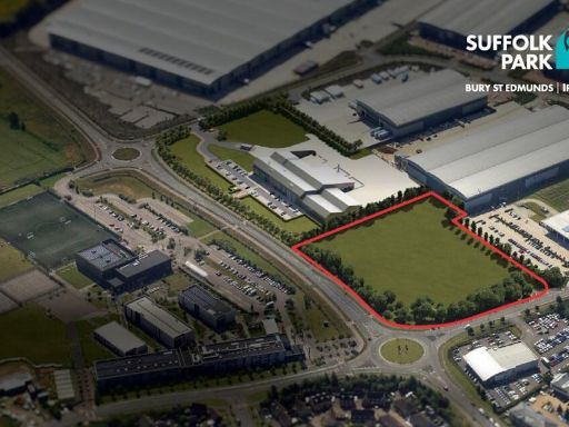 Light industrial facility for sale in Final Plot Available, Suffolk Park, Bury St Edmunds, IP32 7FQ, IP32 — POA • 1 bed • 1 bath
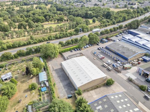 Light industrial facility for sale in Vision House Cavendish Road, Bury St. Edmunds, Suffolk, IP33 3TE, IP33 — £1,200,000 • 1 bed • 1 bath • 11196 ft²
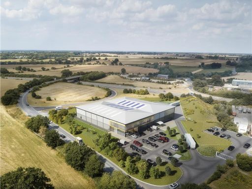 Light industrial facility for sale in Junction 47, Woolpit, Bury St. Edmunds, Suffolk, IP30 — POA • 1 bed • 1 bath
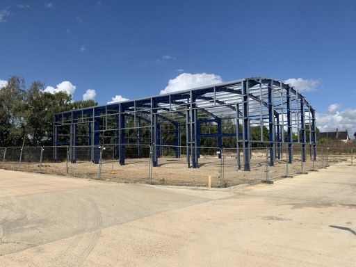 Office for sale in Block D, Risby Business Park, Risby, Bury St Edmunds, IP28 6RD, IP28 — £255,000 • 1 bed • 1 bath • 7700 ft²
 Light industrial facility for sale in Unit 1-3 Brickfields Business Park, Woolpit, Suffolk, IP30 9QS, IP30 — £1,000,000 • 1 bed • 1 bath • 10088 ft²
Meta
- {
"@context": "https://schema.org",
"@type": "Residence",
"name": "Trade counter for sale in SP77, Suffolk Park, Lady Miriam W…",
"description": "",
"url": "https://propertypiper.co.uk/property/9a6ef6ec-ebc7-45d0-8918-1c850bcd8847",
"image": "https://image-a.propertypiper.co.uk/4479b675-ad4b-466c-ab2b-147626472a26-1024.jpeg",
"address": {
"@type": "PostalAddress",
"streetAddress": "Suffolk Biz Park, Kempson Drive, Bury St Edmunds",
"postalCode": "IP32 7FQ",
"addressLocality": "West Suffolk",
"addressRegion": "Bury St Edmunds",
"addressCountry": "England"
},
"geo": {
"@type": "GeoCoordinates",
"latitude": 52.24040601583533,
"longitude": 0.759499724416933
},
"numberOfRooms": 1,
"numberOfBathroomsTotal": 1,
"offers": {
"@type": "Offer",
"price": 1,
"priceCurrency": "GBP",
"availability": "https://schema.org/InStock"
},
"additionalProperty": [
{
"@type": "PropertyValue",
"name": "Feature",
"value": "industrial"
},
{
"@type": "PropertyValue",
"name": "Feature",
"value": "commercial"
},
{
"@type": "PropertyValue",
"name": "Feature",
"value": "modern"
},
{
"@type": "PropertyValue",
"name": "Feature",
"value": "facility"
},
{
"@type": "PropertyValue",
"name": "Feature",
"value": "high ceiling"
},
{
"@type": "PropertyValue",
"name": "Feature",
"value": "large space"
},
{
"@type": "PropertyValue",
"name": "Feature",
"value": "parking"
},
{
"@type": "PropertyValue",
"name": "Feature",
"value": "warehouse"
},
{
"@type": "PropertyValue",
"name": "Feature",
"value": "manufacturing"
},
{
"@type": "PropertyValue",
"name": "Feature",
"value": "logistics"
},
{
"@type": "PropertyValue",
"name": "Feature",
"value": "commercial"
},
{
"@type": "PropertyValue",
"name": "Feature",
"value": "warehouse"
},
{
"@type": "PropertyValue",
"name": "Feature",
"value": "industrial"
},
{
"@type": "PropertyValue",
"name": "Feature",
"value": "loading docks"
},
{
"@type": "PropertyValue",
"name": "Feature",
"value": "large space"
},
{
"@type": "PropertyValue",
"name": "Feature",
"value": "modern build"
},
{
"@type": "PropertyValue",
"name": "Feature",
"value": "logistics"
},
{
"@type": "PropertyValue",
"name": "Feature",
"value": "distribution"
}
]
}
High Res Floorplan Images
Compatible Floorplan Images
FloorplanImages Thumbnail