DN8 5GS - Distribution warehouse for sale in UNITY, Junction 5, M18,…
View on Property Piper
Distribution warehouse for sale in UNITY, Junction 5, M18, Doncaster, DN8 5GS, DN8
Property Details
- Price: £1
- Bedrooms: 1
- Bathrooms: 1
- Property Type: undefined
- Property SubType: undefined
Brochure Descriptions
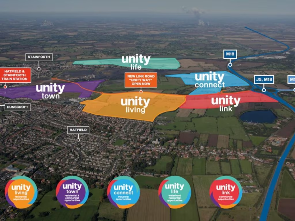
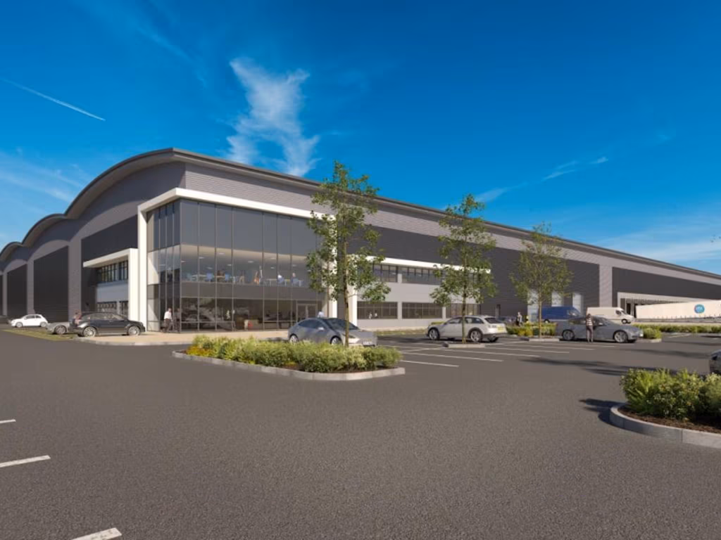
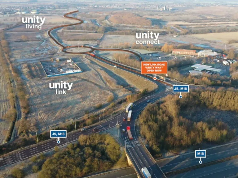
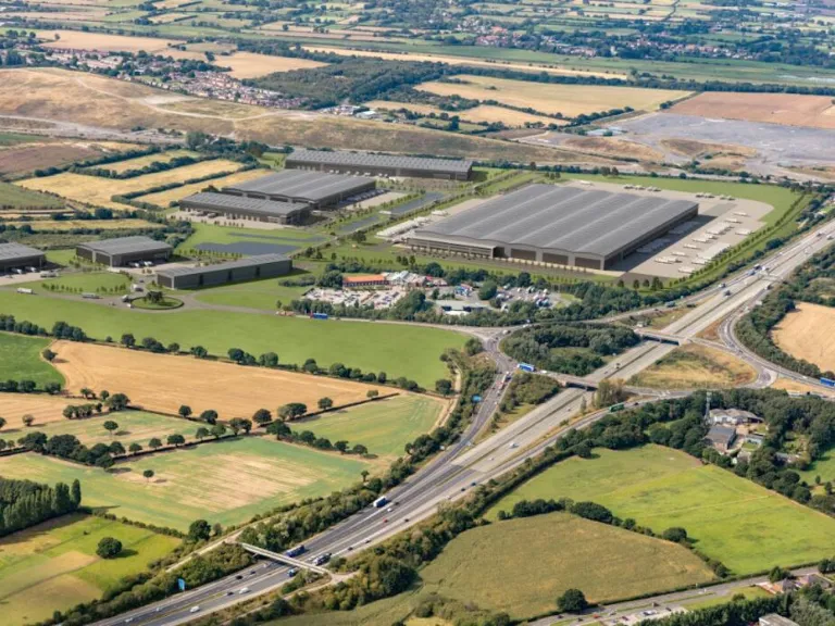
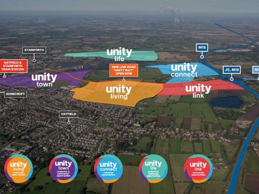
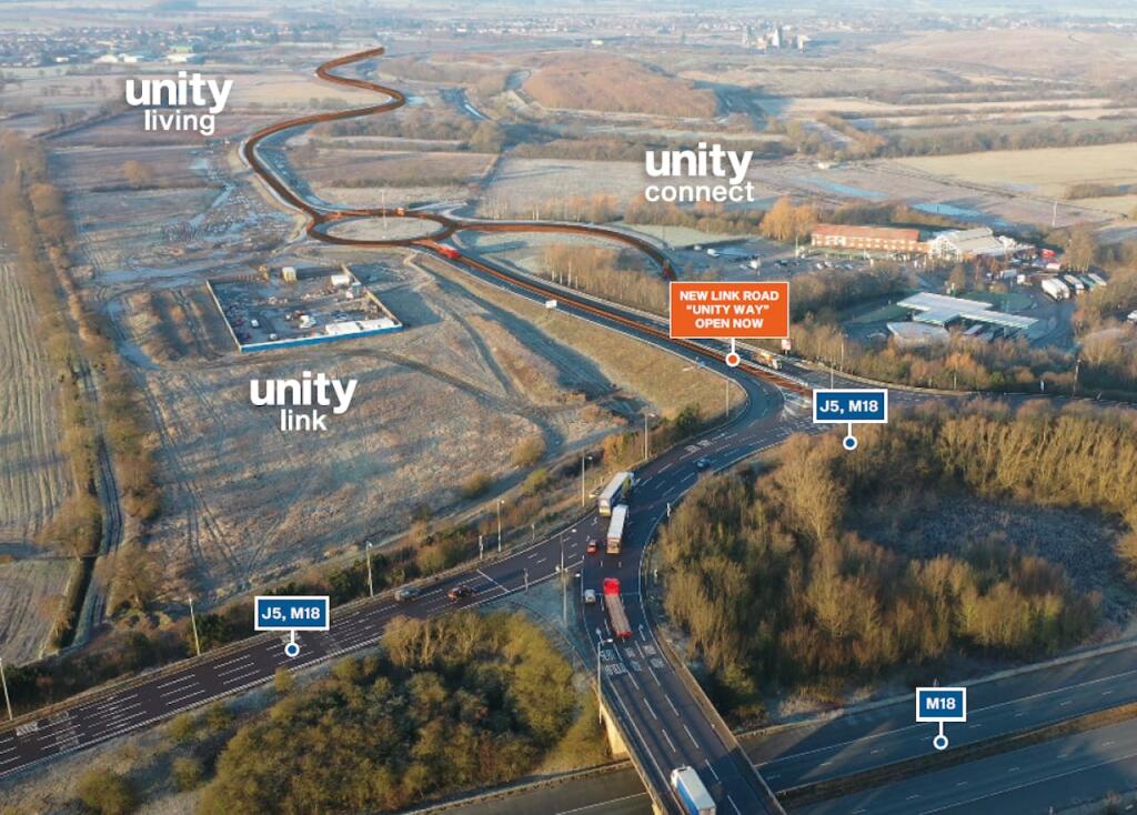
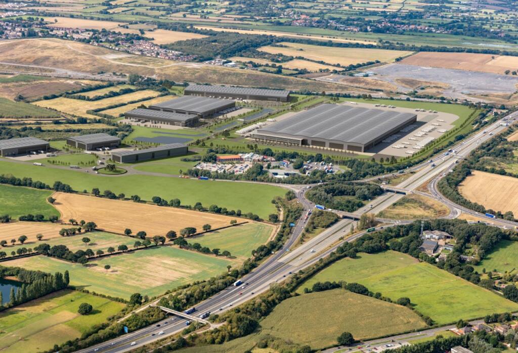
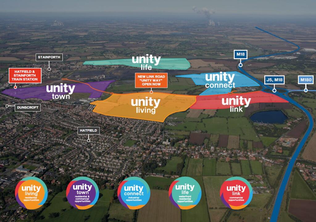
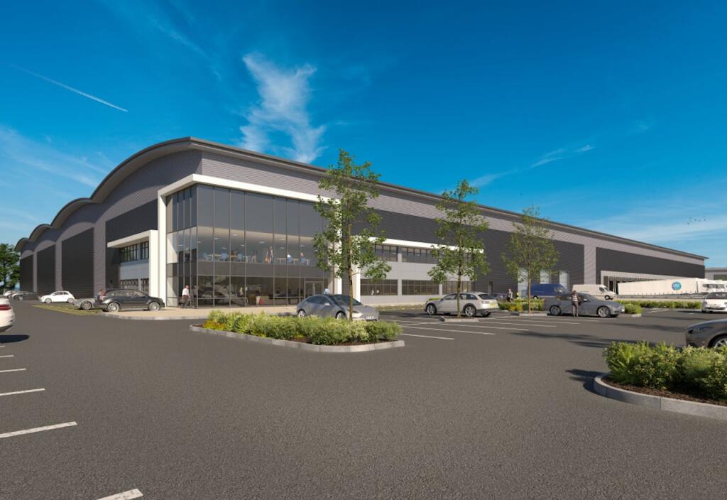
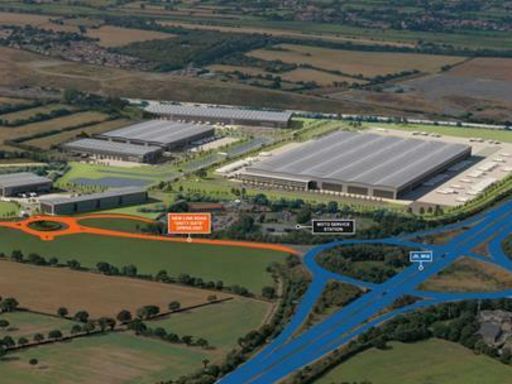
- The property on offer is part of a large-scale development for logistics, manufacturing, and industrial use, offering flexible space that ranges from 100,000 sq ft to a substantial 400,000 sq ft. Located strategically at Junction 5 of the M18, it provides exceptional access and connectivity, ideal for businesses requiring significant floor space and ease of transport. The size is substantial, catering to larger operations or distribution hubs. Given its positioning in Doncaster, South Yorkshire, the development is likely surrounded by complementary industrial and commercial businesses, providing a robust economic environment. The property is designed to support large-scale operations with significant infrastructure potential.
Image Descriptions
-
- distribution center industrial
Textual Property Features
Detected Visual Features
- infrastructure
- development
- industrial
- link road
- transportation
- land
- distribution center
- warehouse
- modern
- large
- high ceiling
- logistics
- commercial
Nearby Schools
- Ash Hill Academy
- Sheep Dip Lane Academy
- Travis St Lawrence Church of England Primary School
- Brooke Primary Academy
- Southfield Primary
- Edenthorpe Hall Primary Academy
- Kirk Sandall Infant School
- Crookesbroom Primary Academy
- Stainforth Kirton Lane Primary School
- West Road Primary Academy
- Tranmoor Primary
- Armthorpe Shaw Wood Academy
- Dunsville Primary School
- Holy Family Catholic Primary School
- Hatfield Woodhouse Primary School
- Green Top
- Trinity Academy
- Thorne King Edward Primary School
- Marshland Primary Academy
- Outwood Academy Danum
- Our Lady of Sorrows Catholic Voluntary Academy
- Armthorpe Academy
- Hungerhill School
- Canon Popham CofE Primary Academy
- Kirk Sandall Junior School
- Barnby Dun Primary Academy
- Long Toft Primary School
Nearest General Shops
- Id: 4192663001
- Tags:
- Addr:
- City: Doncaster
- Country: GB
- Housenumber: 83
- Postcode: DN7 4LE
- Street: Abbey Road
- Suburb: Dunscroft
- Amenity: cafe
- Fhrs:
- Name: Hot Shop
- TagsNormalized:
- Lat: 53.5817164
- Lon: -1.014991
- FullGeoHash: gcx2bfkbhgzu
- PartitionGeoHash: gcx2
- Images:
- FoodStandards: null
- Distance: 1897.8
,- Id: 4192663009
- Tags:
- Name: Abbey Road Cleaners
- Shop: laundry
- TagsNormalized:
- Lat: 53.5817785
- Lon: -1.0149883
- FullGeoHash: gcx2bfkbmp3y
- PartitionGeoHash: gcx2
- Images:
- FoodStandards: null
- Distance: 1893.4
,- Id: 6761365988
- Tags:
- Addr:
- City: Doncaster
- Country: GB
- Housename: Motorway Services
- Postcode: DN8 5GS
- Street: Junction 5
- Fhrs:
- Name: WH Smiths
- Shop: newsagent
- TagsNormalized:
- Lat: 53.5922828
- Lon: -0.9920793
- FullGeoHash: gcx2ckjtdvs5
- PartitionGeoHash: gcx2
- Images:
- FoodStandards:
- Id: 366917
- FHRSID: 366917
- LocalAuthorityBusinessID: PI/000031048
- BusinessName: WH Smiths
- BusinessType: Retailers - other
- BusinessTypeID: 4613
- AddressLine1: Motorway Services
- AddressLine2: Junction 5
- AddressLine3: Doncaster
- AddressLine4: null
- PostCode: DN8 5GS
- RatingValue: 5
- RatingKey: fhrs_5_en-GB
- RatingDate: 2018-10-10
- LocalAuthorityCode: 408
- LocalAuthorityName: Doncaster
- LocalAuthorityWebSite: http://www.doncaster.gov.uk
- LocalAuthorityEmailAddress: food.safety@doncaster.gov.uk
- Scores:
- Hygiene: 0
- Structural: 0
- ConfidenceInManagement: 0
- NewRatingPending: false
- Geocode:
- Longitude: -0.99234100000000
- Latitude: 53.59216000000000
- Distance: 17.5
}
Nearest Supermarkets
- Id: 627994276
- Tags:
- Brand: ALDI
- Brand:wikidata: Q41171672
- Brand:wikipedia: en:Aldi
- Building: retail
- Contact:
- Website: https://stores.aldi.co.uk/thorne/unit-2-quora-retail-park
- Name: Aldi
- Shop: supermarket
- TagsNormalized:
- aldi
- retail
- supermarket
- shop
- Lat: 53.6168392
- Lon: -0.9782084
- FullGeoHash: gcx318xswp4z
- PartitionGeoHash: gcx3
- Images:
- FoodStandards: null
- Distance: 2892.9
,- Id: 485023236
- Tags:
- Addr:
- City: Stainforth
- Postcode: DN7 5DX
- Street: Station Road
- Branch: Stainforth Supermarket
- Brand: Asda
- Brand:wikidata: Q297410
- Brand:wikipedia: en:Asda
- Building: yes
- Contact:
- Website: https://storelocator.asda.com/yorkshire-&-humber/stainforth/station-road
- Fhrs:
- Name: Asda
- Opening_hours: Mo-Sa 07:00-23:00; Su 10:00-16:00
- Operator: Asda Stores Ltd
- Shop: supermarket
- TagsNormalized:
- Lat: 53.5902819
- Lon: -1.027248
- FullGeoHash: gcx2begfp2s7
- PartitionGeoHash: gcx2
- Images:
- FoodStandards:
- Id: 698544
- FHRSID: 698544
- LocalAuthorityBusinessID: PI/000193058
- BusinessName: Asda Supermarket
- BusinessType: Retailers - supermarkets/hypermarkets
- BusinessTypeID: 7840
- AddressLine1: Station Road
- AddressLine2: Stainforth
- AddressLine3: Doncaster
- AddressLine4: null
- PostCode: DN7 5QB
- RatingValue: 5
- RatingKey: fhrs_5_en-GB
- RatingDate: 2022-09-28
- LocalAuthorityCode: 408
- LocalAuthorityName: Doncaster
- LocalAuthorityWebSite: http://www.doncaster.gov.uk
- LocalAuthorityEmailAddress: food.safety@doncaster.gov.uk
- Scores:
- Hygiene: 0
- Structural: 5
- ConfidenceInManagement: 5
- NewRatingPending: false
- Geocode:
- Longitude: -1.02758300000000
- Latitude: 53.58980900000000
- Distance: 2315.8
,- Id: 4192662957
- Tags:
- Name: Co-op
- Opening_hours: Mo-Su 07:00-22:00
- Operator: The Co-operative Group
- Shop: supermarket
- TagsNormalized:
- Lat: 53.5818559
- Lon: -1.0123636
- FullGeoHash: gcx2bfqbfjyu
- PartitionGeoHash: gcx2
- Images:
- FoodStandards: null
- Distance: 1753.9
}
Nearest Religious buildings
- Id: 1786068069
- Tags:
- Amenity: place_of_worship
- Denomination: catholic
- Name: Our Lady of the Assumption
- Religion: christian
- TagsNormalized:
- place of worship
- catholic
- christian
- church
- Lat: 53.5953787
- Lon: -1.0238385
- FullGeoHash: gcx2bswrwydx
- PartitionGeoHash: gcx2
- Images:
- FoodStandards: null
- Distance: 2110.5
,- Id: 3107438663
- Tags:
- Amenity: social_facility
- Name: Church View
- Social_facility: group_home
- Social_facility:for: senior
- Social_facility_for: senior
- TagsNormalized:
- Lat: 53.5754397
- Lon: -0.9998881
- FullGeoHash: gcx2c1pgscv6
- PartitionGeoHash: gcx2
- Images:
- FoodStandards: null
- Distance: 1930.1
,- Id: 552470805
- Tags:
- Amenity: place_of_worship
- Building: yes
- Denomination: anglican
- Name: St Lawrence CofE
- Religion: christian
- Wikidata: Q17530794
- TagsNormalized:
- place of worship
- anglican
- christian
- church
- Lat: 53.5786761
- Lon: -1.000081
- FullGeoHash: gcx2c1xy2mjs
- PartitionGeoHash: gcx2
- Images:
- FoodStandards: null
- Distance: 1589.4
}
Nearest Medical buildings
- Id: 4192671590
- Tags:
- Amenity: doctors
- Name: The Heathfield Centre
- TagsNormalized:
- Lat: 53.5747866
- Lon: -1.0085004
- FullGeoHash: gcx2c0cxu0pd
- PartitionGeoHash: gcx2
- Images:
- FoodStandards: null
- Distance: 2212.1
,- Id: 4192669784
- Tags:
- Amenity: pharmacy
- Dispensing: yes
- Name: Weldricks
- TagsNormalized:
- Lat: 53.5748678
- Lon: -1.0087257
- FullGeoHash: gcx2c112nzpw
- PartitionGeoHash: gcx2
- Images:
- FoodStandards: null
- Distance: 2211.5
,- Id: 4192662955
- Tags:
- Amenity: pharmacy
- Dispensing: yes
- Name: Weldricks
- TagsNormalized:
- Lat: 53.5805897
- Lon: -1.0194998
- FullGeoHash: gcx2bf19ecvg
- PartitionGeoHash: gcx2
- Images:
- FoodStandards: null
- Distance: 2211.1
,- Id: 803089755
- Tags:
- Amenity: doctors
- Building: yes
- Healthcare: doctor
- TagsNormalized:
- doctor
- doctors
- health
- healthcare
- Lat: 53.5748121
- Lon: -1.0085042
- FullGeoHash: gcx2c0cxuhuf
- PartitionGeoHash: gcx2
- Images:
- FoodStandards: null
- Distance: 2209.8
}
Nearest Airports
- Id: 100889514
- Tags:
- Addr:
- Aerodrome: international
- Aerodrome:type: public
- Area: yes
- Cities_served: Doncaster, Sheffield
- Closest_town: Doncaster
- Disused:
- Ele: 17
- Iata: DSA
- Icao: EGCN
- Ifr: yes
- Is_in: Finningley
- Name: Doncaster Sheffield Airport
- Old_iata: FNY
- Old_icao: EGXI
- Old_name: RAF Finningley
- Old_operator: Royal Air Force
- Old_type: military
- Operator: Doncaster Sheffield Airport Limited/Peel Airports
- Source: wikipedia
- Tower_frequency: 128.775
- Vfr: yes
- Website: https://www.robinhoodairport.com/
- Wikidata: Q8996
- Wikipedia: en:Robin Hood Airport Doncaster Sheffield
- TagsNormalized:
- airport
- international airport
- Lat: 53.4761577
- Lon: -1.0054086
- FullGeoHash: gcx21p5chq34
- PartitionGeoHash: gcx2
- Images:
- FoodStandards: null
- Distance: 12932.8
}
Nearest Leisure Facilities
- Id: 1080366244
- Tags:
- TagsNormalized:
- Lat: 53.5820491
- Lon: -0.9995907
- FullGeoHash: gcx2c6245cgh
- PartitionGeoHash: gcx2
- Images:
- FoodStandards: null
- Distance: 1227.3
,- Id: 306674658
- Tags:
- Leisure: park
- Name: Jubilee Fields
- TagsNormalized:
- Lat: 53.58222
- Lon: -0.9952859
- FullGeoHash: gcx2c67701v0
- PartitionGeoHash: gcx2
- Images:
- FoodStandards: null
- Distance: 1127.5
,- Id: 272616507
- Tags:
- TagsNormalized:
- Lat: 53.582312
- Lon: -0.9918693
- FullGeoHash: gcx2c6mexfbt
- PartitionGeoHash: gcx2
- Images:
- FoodStandards: null
- Distance: 1100.4
,- Id: 112325926
- Tags:
- Addr:
- City: Hatfield
- Postcode: DN7 6EP
- Street: Thorne Road
- Description: 18 hole Par 71
- Golf:
- Leisure: golf_course
- Name: Kingswood Golf Centre
- Phone: +44 1405 741343
- Source: Bing
- Website: https://www.kingswoodgolfcentre.co.uk/
- TagsNormalized:
- Lat: 53.5976306
- Lon: -0.9808012
- FullGeoHash: gcx2ctjucdt8
- PartitionGeoHash: gcx2
- Images:
- FoodStandards: null
- Distance: 969.9
,- Id: 305862926
- Tags:
- TagsNormalized:
- Lat: 53.5881368
- Lon: -0.9807919
- FullGeoHash: gcx2cemv9bsx
- PartitionGeoHash: gcx2
- Images:
- FoodStandards: null
- Distance: 884.5
}
Nearest Tourist attractions
- Id: 2186263633
- Tags:
- Name: Hatfield Outdoor Activity Centre
- Tourism: camp_site
- TagsNormalized:
- Lat: 53.5820141
- Lon: -0.9909964
- FullGeoHash: gcx2c6q3u57s
- PartitionGeoHash: gcx2
- Images:
- FoodStandards: null
- Distance: 1136.4
,- Id: 306675576
- Tags:
- TagsNormalized:
- Lat: 53.583373
- Lon: -0.9900012
- FullGeoHash: gcx2c6x1g29w
- PartitionGeoHash: gcx2
- Images:
- FoodStandards: null
- Distance: 993.8
,- Id: 305876594
- Tags:
- Designation: yes
- Name: Gibbon Lane Gypsy and Travellers Site
- Pitches: 10
- Tourism: caravan_site
- TagsNormalized:
- Lat: 53.5987516
- Lon: -0.984672
- FullGeoHash: gcx2ct6gr7rr
- PartitionGeoHash: gcx2
- Images:
- FoodStandards: null
- Distance: 885.4
}
Nearest Train stations
- Id: 7452565703
- Tags:
- Name: Snaith
- Naptan:
- Network: National Rail
- Public_transport: station
- Railway: station
- Ref:
- Source: NPE
- Wikidata: Q2522426
- Wikipedia: en:Snaith railway station
- TagsNormalized:
- Lat: 53.6931673
- Lon: -1.0279398
- FullGeoHash: gcx32we3r7bd
- PartitionGeoHash: gcx3
- Images:
- FoodStandards: null
- Distance: 11469.6
,- Id: 157599125
- Tags:
- Name: Rawcliffe
- Naptan:
- Network: National Rail
- Public_transport: station
- Railway: station
- Ref:
- Source: NPE
- Wikidata: Q2080885
- Wikipedia: en:Rawcliffe railway station
- TagsNormalized:
- Lat: 53.6889426
- Lon: -0.9612713
- FullGeoHash: gcx36ju0bb21
- PartitionGeoHash: gcx3
- Images:
- FoodStandards: null
- Distance: 10949.7
,- Id: 254506703
- Tags:
- Name: Kirk Sandall
- Naptan:
- Network: National Rail
- Operator: Northern Rail
- Public_transport: station
- Railway: station
- Ref:
- Source: wikipedia
- Wikidata: Q2060574
- Wikipedia: en:Kirk Sandall railway station
- TagsNormalized:
- Lat: 53.5636066
- Lon: -1.0745371
- FullGeoHash: gcx0xwcw97zp
- PartitionGeoHash: gcx0
- Images:
- FoodStandards: null
- Distance: 6291.5
,- Id: 254507165
- Tags:
- Name: Thorne South
- Naptan:
- Network: National Rail
- Operator: Northern Rail
- Public_transport: station
- Railway: station
- Ref:
- Source: wikipedia
- Wikidata: Q7796381
- Wikipedia: en:Thorne South railway station
- TagsNormalized:
- Lat: 53.6033332
- Lon: -0.9557108
- FullGeoHash: gcx2fq0n43d3
- PartitionGeoHash: gcx2
- Images:
- FoodStandards: null
- Distance: 2713.6
,- Id: 254505461
- Tags:
- Name: Hatfield & Stainforth
- Naptan:
- Network: National Rail
- Operator: Northern Rail
- Public_transport: station
- Railway: station
- Ref:
- Source: wikipedia
- Wikidata: Q2113263
- Wikipedia: en:Hatfield & Stainforth railway station
- TagsNormalized:
- Lat: 53.5888703
- Lon: -1.0232631
- FullGeoHash: gcx2bewcu1rx
- PartitionGeoHash: gcx2
- Images:
- FoodStandards: null
- Distance: 2076.3
}
Nearest Hotels
- Id: 2030493558
- Tags:
- Amenity: pub
- Name: Wheatley Hotel
- TagsNormalized:
- Lat: 53.5419122
- Lon: -1.0955421
- FullGeoHash: gcx0x5420pbe
- PartitionGeoHash: gcx0
- Images:
- FoodStandards: null
- Distance: 8817.4
,- Id: 577625791
- Tags:
- Addr:
- City: Doncaster
- Housename: The Beverley Inn
- Housenumber: 117
- Postcode: DN3 2JE
- Street: Thorne Road
- Name: The Beverley Inn
- Tourism: hotel
- TagsNormalized:
- Lat: 53.5528511
- Lon: -1.0680802
- FullGeoHash: gcx0xsypzzj8
- PartitionGeoHash: gcx0
- Images:
- FoodStandards: null
- Distance: 6646.7
,- Id: 366310351
- Tags:
- Addr:
- City: Doncaster
- Housename: Motorway Services
- Postcode: DN8 5GS
- Street: Junction 5
- Brand: Travelodge
- Brand:wikidata: Q9361374
- Building: commercial
- Fhrs:
- Authority: Doncaster
- Id: 631756
- Local_authority_id: PI/000173373
- Internet_access: wlan
- Internet_access:fee: customers
- Internet_access:ssid: Travelodge WiFi
- Name: Travelodge
- Tourism: hotel
- TagsNormalized:
- Lat: 53.5918403
- Lon: -0.9926419
- FullGeoHash: gcx2ckj5jg0e
- PartitionGeoHash: gcx2
- Images:
- FoodStandards: null
- Distance: 46.1
}
Tags
- infrastructure
- development
- industrial
- link road
- transportation
- land
- industrial
- distribution center
- warehouse
- modern
- large
- high ceiling
- logistics
- commercial
Local Market Stats
- Average Price/sqft: £150
- Avg Income: £33100
- Rental Yield: 4.8%
- Social Housing: 4%
- Planning Success Rate: 99%
Similar Properties
 Light industrial facility for sale in Unity, Hatfield Junction 5 M18, Hugh Hill Lane, Doncaster, DN8 — POA • 1 bed • 1 bath
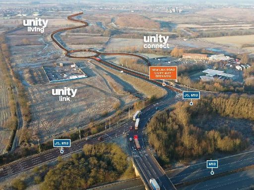 Distribution warehouse for sale in Unity, Doncaster, DN8 5GS, DN8 — POA • 1 bed • 1 bath • 22000 ft²
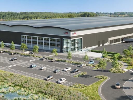 Light industrial facility for sale in Unity 375, Junction 5 M18, Hugh Hill Lane, Doncaster, DN8 5GS, DN8 — £125 • 1 bed • 1 bath
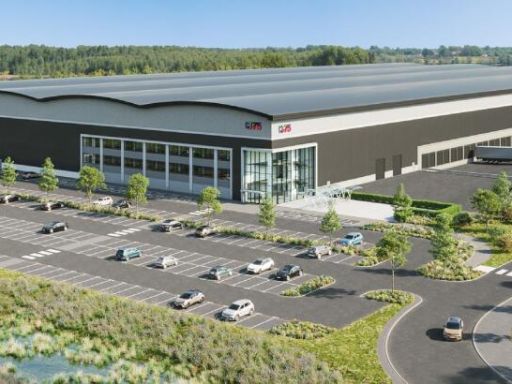 Distribution warehouse for sale in Unity 375, Hugh Hill Lane, Doncaster, DN8 5GS, DN8 — POA • 1 bed • 1 bath
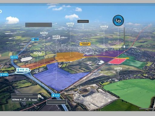 Land for sale in Unity Park, Waggons Way, Stainforth, Doncaster, South Yorkshire, DN7 5TZ, DN7 — POA • 1 bed • 1 bath
 Storage facility for sale in Unity Park, Junction 5 M18, Doncaster, DN7 5TZ, DN7 — POA • 1 bed • 1 bath
Meta
- {
"@context": "https://schema.org",
"@type": "Residence",
"name": "Distribution warehouse for sale in UNITY, Junction 5, M18,…",
"description": "",
"url": "https://propertypiper.co.uk/property/40702e89-617f-4c42-9ac9-6c62b57760f6",
"image": "https://image-a.propertypiper.co.uk/289e945c-2965-4f5f-a6ce-dd10365068b1-1024.jpeg",
"address": {
"@type": "PostalAddress",
"streetAddress": "UNITY, Junction 5, M18, Doncaster, DN8 5GS",
"postalCode": "DN8 5GS",
"addressLocality": "Doncaster",
"addressRegion": "Don Valley",
"addressCountry": "England"
},
"geo": {
"@type": "GeoCoordinates",
"latitude": 53.592204444364974,
"longitude": -0.9923090978400257
},
"numberOfRooms": 1,
"numberOfBathroomsTotal": 1,
"offers": {
"@type": "Offer",
"price": 1,
"priceCurrency": "GBP",
"availability": "https://schema.org/InStock"
},
"additionalProperty": [
{
"@type": "PropertyValue",
"name": "Feature",
"value": "infrastructure"
},
{
"@type": "PropertyValue",
"name": "Feature",
"value": "development"
},
{
"@type": "PropertyValue",
"name": "Feature",
"value": "industrial"
},
{
"@type": "PropertyValue",
"name": "Feature",
"value": "link road"
},
{
"@type": "PropertyValue",
"name": "Feature",
"value": "transportation"
},
{
"@type": "PropertyValue",
"name": "Feature",
"value": "land"
},
{
"@type": "PropertyValue",
"name": "Feature",
"value": "industrial"
},
{
"@type": "PropertyValue",
"name": "Feature",
"value": "distribution center"
},
{
"@type": "PropertyValue",
"name": "Feature",
"value": "warehouse"
},
{
"@type": "PropertyValue",
"name": "Feature",
"value": "modern"
},
{
"@type": "PropertyValue",
"name": "Feature",
"value": "large"
},
{
"@type": "PropertyValue",
"name": "Feature",
"value": "high ceiling"
},
{
"@type": "PropertyValue",
"name": "Feature",
"value": "logistics"
},
{
"@type": "PropertyValue",
"name": "Feature",
"value": "commercial"
}
]
}