AL4 0LB - Warehouse for sale in Lyon Way, St. Albans, AL4 0LB, AL4
View on Property Piper
Warehouse for sale in Lyon Way, St. Albans, AL4 0LB, AL4
Property Details
- Price: £2350000
- Bedrooms: 1
- Bathrooms: 1
- Property Type: undefined
- Property SubType: undefined
Brochure Descriptions
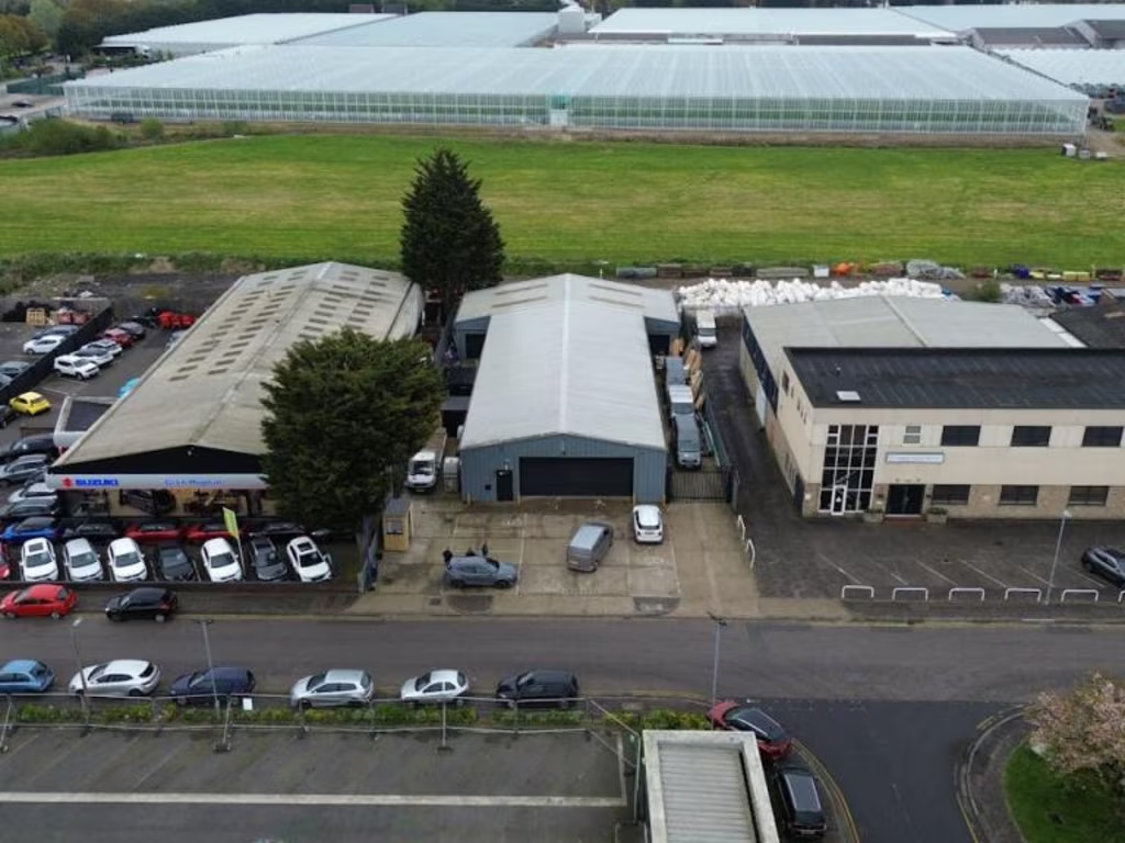
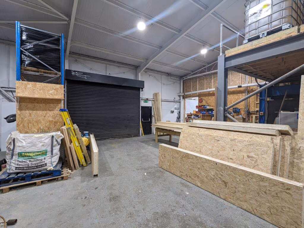
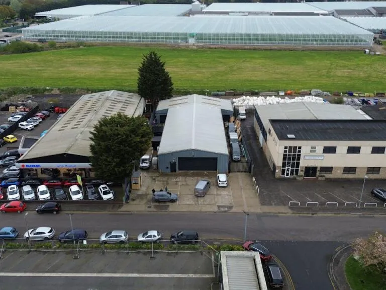
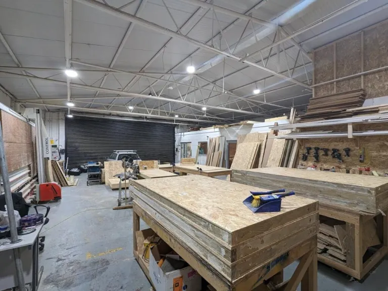
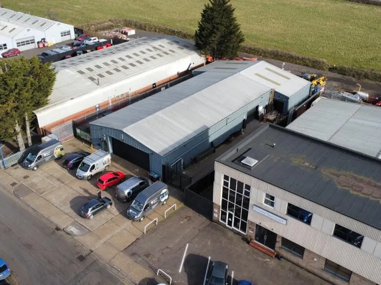
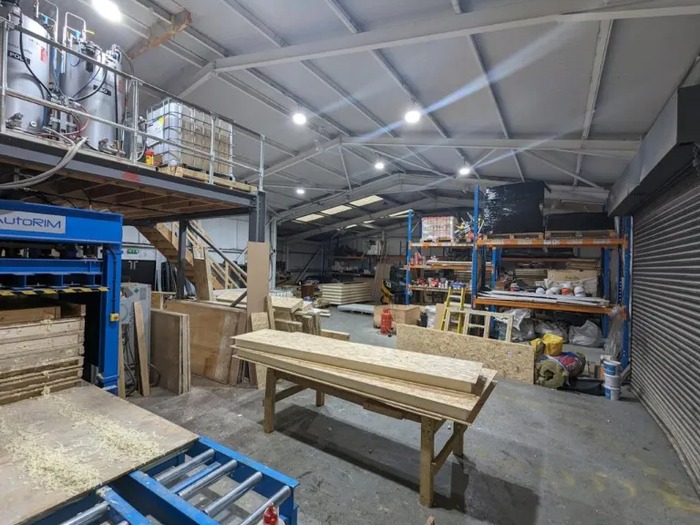
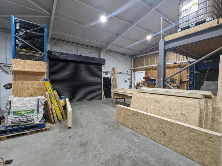
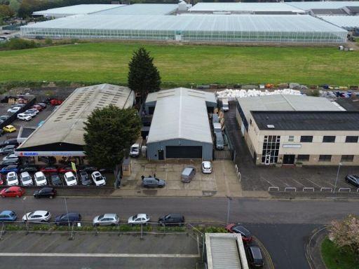
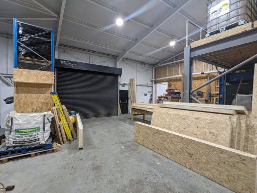
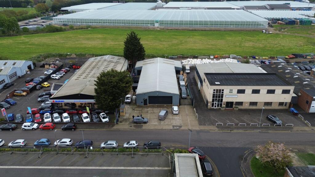
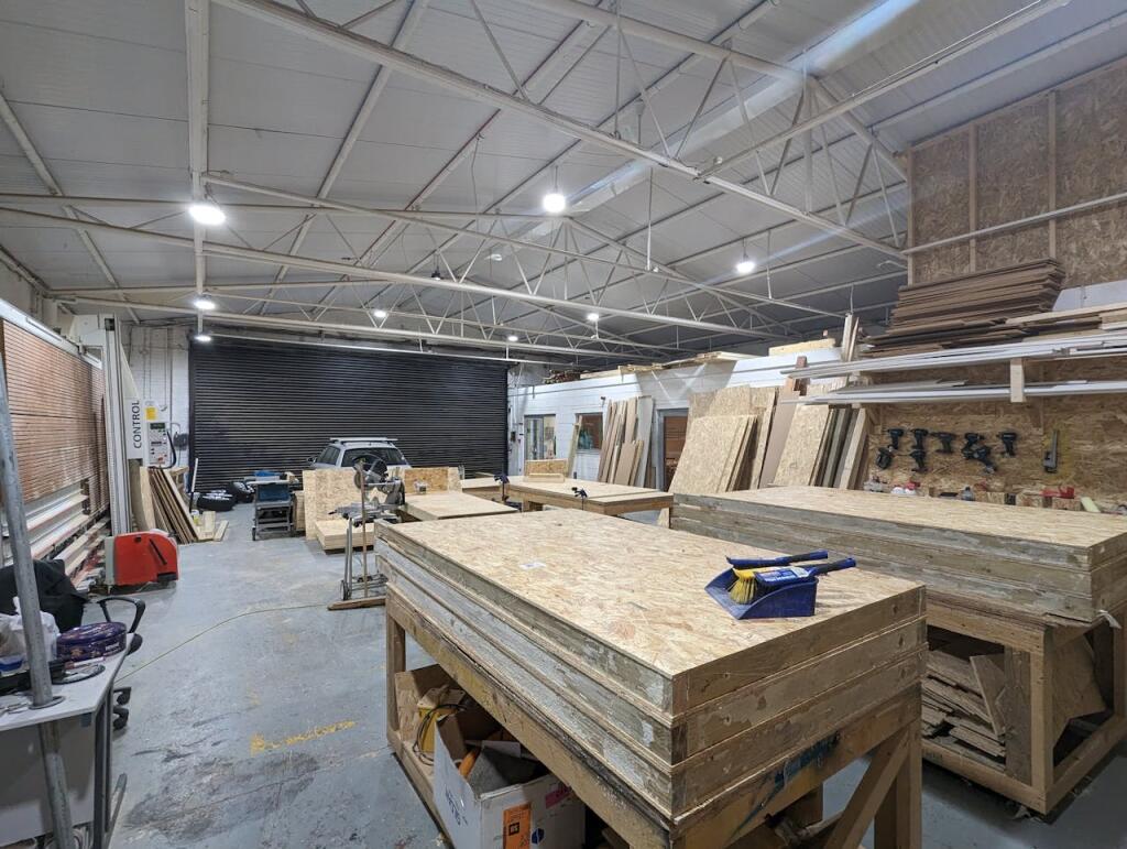
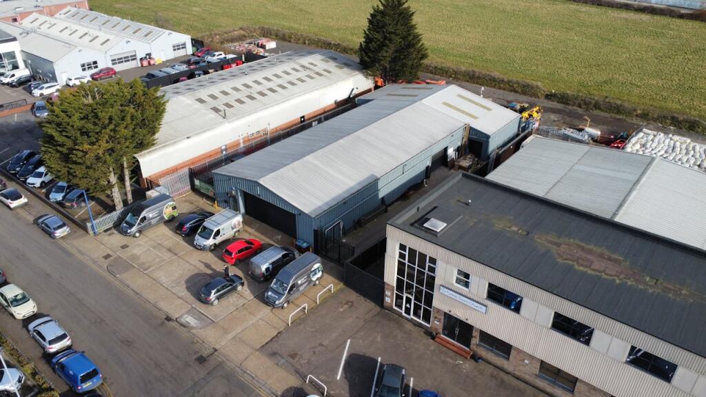
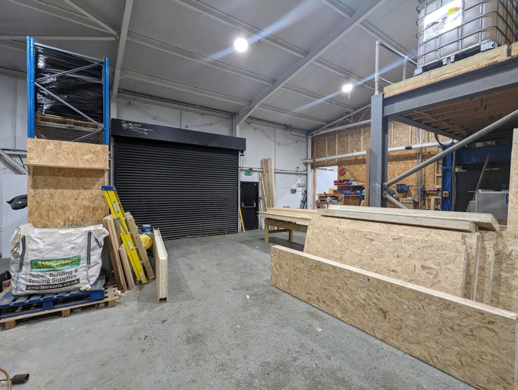
- This is an industrial/warehouse unit located in a commercial area of St. Albans, Hertfordshire. The property is situated alongside other commercial buildings and offers significant space suitable for manufacturing or storage needs. The exterior roof and walls are corrugated metal, indicative of industrial construction, allowing for ease of maintenance. Inside, the unit features a large and open floor space with high ceilings, perfect for accommodating heavy-duty operations or equipment. It also includes designated workbenches and ample room for bulk storage, making it highly functional for a variety of business activities. There are generous vehicular access points and parking space available at the front.
- The property is currently used as a workshop/industrial unit, featuring four loading doors—one at the front and three at the side. The premises offer W/C facilities, office space, and a large open industrial area. Externally, there is space suitable for accommodating a large van and parking/loading area to the front. The unit has ample parking space, including up to 8 parking spaces at the front and additional driveways on each side for parking or storage access. The overall size of the premises is large enough to support industrial operations.
Image Descriptions
- industrial property industrial
- warehouse workshop industrial
Textual Property Features
Detected Visual Features
- industrial unit
- warehouse
- commercial property
- metal roofing
- parking
- business premises
- storage
- light industrial
- industrial
- high ceiling
- large space
- workshop
- commercial
- metal trusses
- roller shutter
- potential
Nearby Schools
- Beaumont School
- Samuel Ryder Academy
- Camp Primary and Nursery School
- Green Lanes Primary School
- De Havilland Primary School
- St Alban & St Stephen Catholic Primary School & Nursery
- Wheatfields Junior Mixed School
- Sandridge School
- Bowmansgreen Primary School
- Cunningham Hill Junior School
- Nicholas Breakspear Catholic School
- Links Hatfield Academy
- Hatfield Community Free School
- Fleetville Junior School
- St John Fisher Catholic Primary School, a Voluntary Academy
- Wheatfields Infants' and Nursery School
- London Colney Primary & Nursery School
- Colney Heath Junior Mixed Infant and Nursery School
- Windermere Primary School
- Cunningham Hill Infant School
- Bishop's Hatfield Girls' School
- Howe Dell Primary School
- Fleetville Infant and Nursery School
- Verulam School
- Oakwood Primary School
- Skyswood Primary & Nursery School
- Sandringham School
- Manor Lodge School
Nearest General Shops
- Id: 820426593
- Tags:
- Brand: Screwfix
- Brand:wikidata: Q7439115
- Brand:wikipedia: en:Screwfix
- Building: yes
- Building:levels: 1
- Name: Screwfix
- Shop: doityourself
- TagsNormalized:
- Lat: 51.7520322
- Lon: -0.277371
- FullGeoHash: gcpy3tnj2y10
- PartitionGeoHash: gcpy
- Images:
- FoodStandards: null
- Distance: 214.1
,- Id: 820426591
- Tags:
- Brand: Formula One Autocentres
- Brand:wikidata: Q79239635
- Building: yes
- Building:levels: 1
- Name: Formula One Autocentres
- Shop: car_repair
- TagsNormalized:
- autocentre
- car repair
- repair
- shop
- Lat: 51.7521172
- Lon: -0.277086
- FullGeoHash: gcpy3tnjzmve
- PartitionGeoHash: gcpy
- Images:
- FoodStandards: null
- Distance: 197.9
,- Id: 4370121
- Tags:
- Brand: Honda
- Brand:wikidata: Q9584
- Brand:wikipedia: en:Honda
- Building: yes
- Name: Honda
- Operator: Brayley
- Shop: car
- TagsNormalized:
- Lat: 51.7523751
- Lon: -0.2764368
- FullGeoHash: gcpy3tnxqtcy
- PartitionGeoHash: gcpy
- Images:
- FoodStandards: null
- Distance: 169.7
}
Nearest Grocery shops
- Id: 2716413547
- Tags:
- Alt_name: De Havilland Campus Shop
- Brand: Premier
- Brand:wikidata: Q7240340
- Brand:wikipedia: en:Premier Stores
- Name: Premier
- Shop: convenience
- TagsNormalized:
- Lat: 51.7616138
- Lon: -0.2503184
- FullGeoHash: gcpy6qctr0jj
- PartitionGeoHash: gcpy
- Images:
- FoodStandards: null
- Distance: 1997.2
,- Id: 194185681
- Tags:
- Building: retail
- Building:levels: 2
- Building:part: retail
- Name: Oaklands Store
- Shop: convenience
- TagsNormalized:
- Lat: 51.7518162
- Lon: -0.2939363
- FullGeoHash: gcpy3m1unvc0
- PartitionGeoHash: gcpy
- Images:
- FoodStandards: null
- Distance: 1348
,- Id: 218716860
- Tags:
- Building: yes
- Shop: convenience
- TagsNormalized:
- Lat: 51.7551692
- Lon: -0.2679192
- FullGeoHash: gcpy3vsztnbc
- PartitionGeoHash: gcpy
- Images:
- FoodStandards: null
- Distance: 598.3
}
Nearest Supermarkets
- Id: 647222504
- Tags:
- Addr:
- City: Hatfield
- Country: GB
- Housenumber: 11
- Postcode: AL10 9RQ
- Street: Parkhouse Court
- Brand: ALDI
- Brand:wikidata: Q41171672
- Brand:wikipedia: en:Aldi
- Contact:
- Website: https://stores.aldi.co.uk/hatfield/11-parkhouse-court
- Name: Aldi
- Opening_hours: Mo-Sa 08:00-22:00, Su 11:00-17:00
- Shop: supermarket
- TagsNormalized:
- Lat: 51.7630643
- Lon: -0.2407918
- FullGeoHash: gcpy6x0ttns9
- PartitionGeoHash: gcpy
- Images:
- FoodStandards: null
- Distance: 2641.1
,- Id: 878155331
- Tags:
- Addr:
- City: St Albans
- Postcode: AL4 9TU
- Street: The Ridgeway
- Brand: M&S Foodhall
- Brand:wikidata: Q714491
- Brand:wikipedia: en:Marks & Spencer
- Building: yes
- Contact:
- Website: https://www.marksandspencer.com/stores/marshalswick-foodhall-2109
- Name: M&S Foodhall
- Shop: supermarket
- TagsNormalized:
- m&s foodhall
- supermarket
- shop
- Lat: 51.7631396
- Lon: -0.306826
- FullGeoHash: gcpy3p0w4ktg
- PartitionGeoHash: gcpy
- Images:
- FoodStandards: null
- Distance: 2579.4
,- Id: 4370426
- Tags:
- Addr:
- Housenumber: 244
- Postcode: AL1 4SU
- Street: Hatfield Road
- Brand: Morrisons
- Brand:wikidata: Q922344
- Brand:wikipedia: en:Morrisons
- Building: store
- Contact:
- Website: https://my.morrisons.com/storefinder/317
- Name: Morrisons
- Opening_hours: Mo-Sa 07:00-22:00; Su 10:00-16:00
- Shop: supermarket
- TagsNormalized:
- Lat: 51.751448
- Lon: -0.3113174
- FullGeoHash: gcpy2vj61c0u
- PartitionGeoHash: gcpy
- Images:
- FoodStandards: null
- Distance: 2544.2
}
Nearest Religious buildings
- Id: 211113275
- Tags:
- Amenity: place_of_worship
- Building: yes
- Denomination: Subset_of_Christian_Evangelical_Church
- Name: Brethern's Meeting Rooms
- Religion: christian
- TagsNormalized:
- place of worship
- christian
- church
- evangelical
- Lat: 51.7602372
- Lon: -0.310867
- FullGeoHash: gcpy2ytthr8c
- PartitionGeoHash: gcpy
- Images:
- FoodStandards: null
- Distance: 2692
,- Id: 194188399
- Tags:
- Amenity: place_of_worship
- Name: Ashley Church
- Religion: christian
- TagsNormalized:
- place of worship
- church
- christian
- Lat: 51.7524577
- Lon: -0.3064938
- FullGeoHash: gcpy3j0zfjme
- PartitionGeoHash: gcpy
- Images:
- FoodStandards: null
- Distance: 2214.4
,- Id: 787896810
- Tags:
- HE_ref: 1347187
- Addr:
- City: Colney Health
- Postcode: AL4 0NH
- Street: Church Lane
- Amenity: place_of_worship
- Building: church
- Denomination: anglican
- Email: office@stmarkscolneyheath.co.uk
- Heritage: 2
- Heritage:operator: he
- Listed_status: Grade II
- Name: St Mark's
- Phone: +44 1727 825175
- Religion: christian
- Service_times: Su 08:30,10:30
- Website: https://stmarkscolneyheath.co.uk/
- Wikidata: Q26630656
- TagsNormalized:
- place of worship
- church
- anglican
- christian
- Lat: 51.7414144
- Lon: -0.2676563
- FullGeoHash: gcpy3gjpe4sz
- PartitionGeoHash: gcpy
- Images:
- FoodStandards: null
- Distance: 1218.3
}
Nearest Medical buildings
- Id: 2046971856
- Tags:
- Amenity: pharmacy
- Brand: Jhoots Pharmacy
- Brand:wikidata: Q91440588
- Dispensing: yes
- Healthcare: pharmacy
- Name: Jhoots Pharmacy
- TagsNormalized:
- Lat: 51.7446938
- Lon: -0.3017154
- FullGeoHash: gcpy35u69w09
- PartitionGeoHash: gcpy
- Images:
- FoodStandards: null
- Distance: 2032
,- Id: 2046592508
- Tags:
- Addr:
- Housenumber: 61
- Postcode: AL4 0AY
- Street: Russet Drive
- Amenity: doctors
- Healthcare: doctor
- Name: Highfield Surgery
- TagsNormalized:
- doctor
- doctors
- health
- healthcare
- surgery
- Lat: 51.7447858
- Lon: -0.3011631
- FullGeoHash: gcpy35uenrhw
- PartitionGeoHash: gcpy
- Images:
- FoodStandards: null
- Distance: 1992.9
,- Id: 4710098
- Tags:
- Building: yes
- Leisure: sports_centre
- Name: Charters Health Club
- TagsNormalized:
- sports
- sports centre
- leisure
- health
- club
- Lat: 51.7447713
- Lon: -0.2999508
- FullGeoHash: gcpy35ve4skr
- PartitionGeoHash: gcpy
- Images:
- FoodStandards: null
- Distance: 1916.6
,- Id: 35038877
- Tags:
- Amenity: clinic
- Building: yes
- Healthcare: clinic
- Name: Lambourn Grove Elderly Care Centre
- Website: https://www.nhs.uk/Services/clinics/Overview/DefaultView.aspx?id=33392
- TagsNormalized:
- Lat: 51.7482672
- Lon: -0.2950371
- FullGeoHash: gcpy3k3pt0hm
- PartitionGeoHash: gcpy
- Images:
- FoodStandards: null
- Distance: 1469.7
}
Nearest Airports
- Id: 110273499
- Tags:
- Addr:
- Country: GB
- Postcode: LU2 9LY
- Aerodrome: international
- Aerodrome:type: public
- Aeroway: aerodrome
- Alt_name: London Luton
- Iata: LTN
- Icao: EGGW
- Name: London Luton Airport
- Website: https://www.london-luton.co.uk/
- Wikidata: Q8712
- Wikipedia: en:Luton Airport
- TagsNormalized:
- airport
- international airport
- Lat: 51.8780363
- Lon: -0.3701408
- FullGeoHash: gcpxps47rngh
- PartitionGeoHash: gcpx
- Images:
- FoodStandards: null
- Distance: 15529
,- Id: 495488524
- Tags:
- Aerodrome: international
- Aerodrome:type: public
- Aeroway: aerodrome
- Alt_name: Stansted
- Iata: STN
- Icao: EGSS
- Is_in: Essex,England,UK
- Name: London Stansted Airport
- Ref: STN
- Source: Gagravarr_Airports
- Website: https://www.stanstedairport.com/
- Wikidata: Q8709
- Wikipedia: en:London Stansted Airport
- TagsNormalized:
- airport
- international airport
- Lat: 51.8869677
- Lon: 0.2429264
- FullGeoHash: u10pjt8zkxg4
- PartitionGeoHash: u10p
- Images:
- FoodStandards: null
- Distance: 38612
,- Id: 121158889
- Tags:
- Aerodrome: continental
- Aeroway: aerodrome
- Fhrs:
- Authority: City of London Corporation
- Iata: LCY
- Icao: EGLC
- Name: London City Airport
- Operator: London City Airport Limited
- Ref: LCY
- Website: https://www.londoncityairport.com/
- Wikidata: Q8982
- Wikipedia: en:London City Airport
- TagsNormalized:
- airport
- continental airport
- Lat: 51.5042658
- Lon: 0.0539987
- FullGeoHash: u10j10p64702
- PartitionGeoHash: u10j
- Images:
- FoodStandards: null
- Distance: 35634.3
}
Nearest Leisure Facilities
- Id: 499994333
- Tags:
- Leisure: pitch
- Sport: rugby_union
- TagsNormalized:
- pitch
- leisure
- rugby
- rugby union
- sports
- Lat: 51.7553303
- Lon: -0.2724409
- FullGeoHash: gcpy3vc8esv6
- PartitionGeoHash: gcpy
- Images:
- FoodStandards: null
- Distance: 440
,- Id: 499994334
- Tags:
- Leisure: pitch
- Sport: soccer
- TagsNormalized:
- Lat: 51.7553011
- Lon: -0.2741106
- FullGeoHash: gcpy3vb2kz2k
- PartitionGeoHash: gcpy
- Images:
- FoodStandards: null
- Distance: 416.9
,- Id: 499994337
- Tags:
- Leisure: pitch
- Sport: rugby_union
- TagsNormalized:
- pitch
- leisure
- rugby
- rugby union
- sports
- Lat: 51.754717
- Lon: -0.2719775
- FullGeoHash: gcpy3v9vn6wb
- PartitionGeoHash: gcpy
- Images:
- FoodStandards: null
- Distance: 387.9
,- Id: 499994335
- Tags:
- Leisure: pitch
- Sport: soccer
- TagsNormalized:
- Lat: 51.7548203
- Lon: -0.2738671
- FullGeoHash: gcpy3v8tdmvb
- PartitionGeoHash: gcpy
- Images:
- FoodStandards: null
- Distance: 364.7
,- Id: 499994336
- Tags:
- Leisure: pitch
- Sport: soccer
- TagsNormalized:
- Lat: 51.7543368
- Lon: -0.2734011
- FullGeoHash: gcpy3v8fv79k
- PartitionGeoHash: gcpy
- Images:
- FoodStandards: null
- Distance: 316.3
}
Nearest Tourist attractions
- Id: 810220471
- Tags:
- Access: private
- Addr:
- City: St Albans
- Postcode: AL4 0QH
- Street: Roestock Lane
- Fixme: Camp site might be larger than this, including nearby fields
- Name: Cherry Green Trees
- Tourism: camp_site
- Website: http://www.cherrygreentrees.co.uk/
- TagsNormalized:
- Lat: 51.7439288
- Lon: -0.2486975
- FullGeoHash: gcpy67dyhzmw
- PartitionGeoHash: gcpy
- Images:
- FoodStandards: null
- Distance: 1959.6
,- Id: 9910680478
- Tags:
- Fixme: Need to map out properly as polygon along with neighbouring site
- Name: Woodstock
- Tourism: caravan_site
- TagsNormalized:
- Lat: 51.7651392
- Lon: -0.2893646
- FullGeoHash: gcpy3rt3c365
- PartitionGeoHash: gcpy
- Images:
- FoodStandards: null
- Distance: 1829.9
,- Id: 26708067
- Tags:
- Name: Barley Mow Caravan Site
- Tourism: caravan_site
- TagsNormalized:
- Lat: 51.742159
- Lon: -0.279074
- FullGeoHash: gcpy3ekgcje3
- PartitionGeoHash: gcpy
- Images:
- FoodStandards: null
- Distance: 1094.1
}
Nearest Hotels
- Id: 532939571
- Tags:
- Addr:
- City: Hatfield
- Postcode: AL10 9AF
- Street: Roehyde Way
- Brand: Mercure
- Brand:wikidata: Q1709809
- Brand:wikipedia: en:Mercure (hotel)
- Building: yes
- Name: Mercure Hatfield Oak Hotel
- Tourism: hotel
- Wikidata: Q83558692
- TagsNormalized:
- Lat: 51.745896
- Lon: -0.2405597
- FullGeoHash: gcpy6s0cdw1t
- PartitionGeoHash: gcpy
- Images:
- FoodStandards: null
- Distance: 2410.3
,- Id: 702117663
- Tags:
- Addr:
- City: Hatfield
- Postcode: AL10 9RH
- Street: St. Albans Road West
- Building: yes
- Building:levels: 2
- Name: The Comet
- Tourism: hotel
- Wikidata: Q26394020
- TagsNormalized:
- Lat: 51.760254
- Lon: -0.2441142
- FullGeoHash: gcpy6qwjrdxm
- PartitionGeoHash: gcpy
- Images:
- FoodStandards: null
- Distance: 2295.5
,- Id: 2266476578
- Tags:
- Alt_name: Longcroft Cattery
- Amenity: animal_boarding
- Animal_boarding: cat
- Name: Longcroft Luxury Cat Hotel St Albans
- TagsNormalized:
- Lat: 51.7494354
- Lon: -0.2993183
- FullGeoHash: gcpy3hwn33un
- PartitionGeoHash: gcpy
- Images:
- FoodStandards: null
- Distance: 1734.3
}
Tags
- industrial unit
- warehouse
- commercial property
- metal roofing
- parking
- business premises
- storage
- light industrial
- industrial
- warehouse
- high ceiling
- large space
- workshop
- storage
- commercial
- metal trusses
- roller shutter
- potential
Local Market Stats
- Average Price/sqft: £582
- Avg Income: £61000
- Rental Yield: 2.6%
- Social Housing: 6%
- Planning Success Rate: 80%
AirBnB Data
- 1km average: £60/night
- Listings in 1km: 1
Similar Properties
 Distribution warehouse for sale in Unit U, Lyon Way, St. Albans, Hertfordshire, AL4 — POA • 1 bed • 1 bath • 14357 ft²
 Industrial park for sale in Former ATS Unit, Lyon Way, St. Albans, Hertfordshire, AL4 — £2,300,000 • 1 bed • 1 bath • 6201 ft²
 Light industrial facility for sale in 25 Travellers Lane, Fusion House, Welham Green, Herts AL9 7HF, AL9 — £2,495,000 • 1 bed • 1 bath • 8608 ft²
 Light industrial facility for sale in 6 Fountain Drive, Mead Lane, Hertford, SG13 7UB, SG13 — £750,000 • 1 bed • 1 bath • 2938 ft²
 Light industrial facility for sale in Abbey House, Wellington Road, London Colney, Hertfordshire, AL2 1EY, AL2 — £4,950,000 • 1 bed • 1 bath • 25360 ft²
 Warehouse for sale in Unit 10 Chancerygate Business Centre, Whiteleaf Road, Hemel Hempstead, HP3 9HD, HP3 — £720,000 • 1 bed • 1 bath • 3385 ft²
Meta
- {
"@context": "https://schema.org",
"@type": "Residence",
"name": "Warehouse for sale in Lyon Way, St. Albans, AL4 0LB, AL4",
"description": "",
"url": "https://propertypiper.co.uk/property/01217ea9-497d-4886-a436-65e0a124eb8a",
"image": "https://image-a.propertypiper.co.uk/5a6621e9-f289-4415-8044-902268ebcedd-1024.jpeg",
"address": {
"@type": "PostalAddress",
"streetAddress": "FOREST TOWN CHURCH, THE VENUE, LYON WAY",
"postalCode": "AL4 0LB",
"addressLocality": "St Albans",
"addressRegion": "St Albans",
"addressCountry": "England"
},
"geo": {
"@type": "GeoCoordinates",
"latitude": 51.751555023516985,
"longitude": -0.2743580313095669
},
"numberOfRooms": 1,
"numberOfBathroomsTotal": 1,
"floorSize": {
"@type": "QuantitativeValue",
"value": 6331,
"unitCode": "FTK"
},
"offers": {
"@type": "Offer",
"price": 2350000,
"priceCurrency": "GBP",
"availability": "https://schema.org/InStock"
},
"additionalProperty": [
{
"@type": "PropertyValue",
"name": "Feature",
"value": "industrial unit"
},
{
"@type": "PropertyValue",
"name": "Feature",
"value": "warehouse"
},
{
"@type": "PropertyValue",
"name": "Feature",
"value": "commercial property"
},
{
"@type": "PropertyValue",
"name": "Feature",
"value": "metal roofing"
},
{
"@type": "PropertyValue",
"name": "Feature",
"value": "parking"
},
{
"@type": "PropertyValue",
"name": "Feature",
"value": "business premises"
},
{
"@type": "PropertyValue",
"name": "Feature",
"value": "storage"
},
{
"@type": "PropertyValue",
"name": "Feature",
"value": "light industrial"
},
{
"@type": "PropertyValue",
"name": "Feature",
"value": "industrial"
},
{
"@type": "PropertyValue",
"name": "Feature",
"value": "warehouse"
},
{
"@type": "PropertyValue",
"name": "Feature",
"value": "high ceiling"
},
{
"@type": "PropertyValue",
"name": "Feature",
"value": "large space"
},
{
"@type": "PropertyValue",
"name": "Feature",
"value": "workshop"
},
{
"@type": "PropertyValue",
"name": "Feature",
"value": "storage"
},
{
"@type": "PropertyValue",
"name": "Feature",
"value": "commercial"
},
{
"@type": "PropertyValue",
"name": "Feature",
"value": "metal trusses"
},
{
"@type": "PropertyValue",
"name": "Feature",
"value": "roller shutter"
},
{
"@type": "PropertyValue",
"name": "Feature",
"value": "potential"
}
]
}
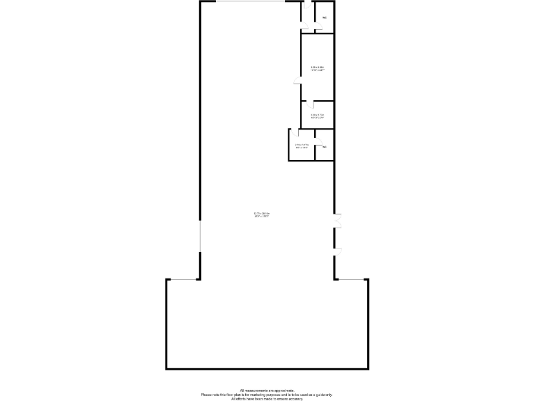
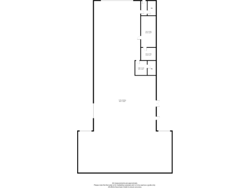
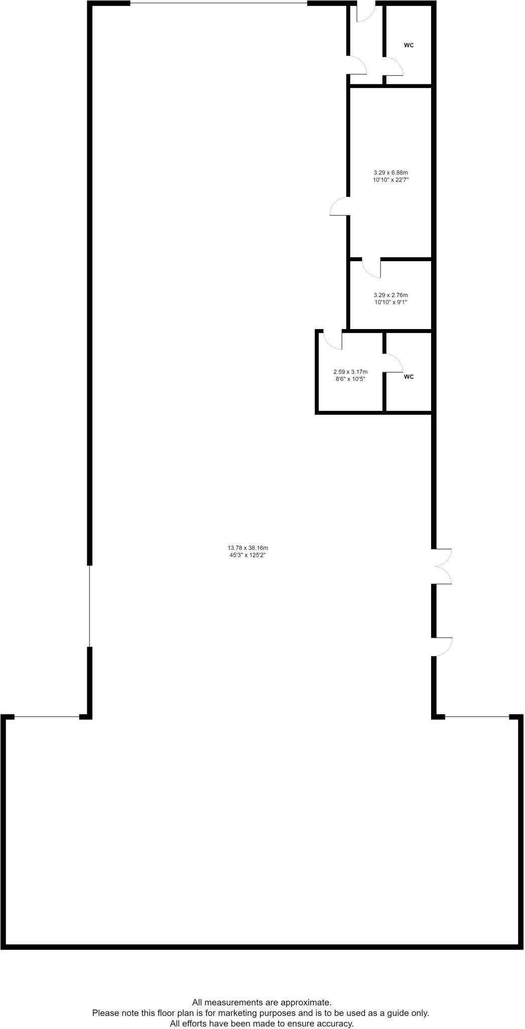
High Res Floorplan Images
Compatible Floorplan Images
FloorplanImages Thumbnail