SE20 7SS - 1 bedroom flat for sale in Croydon Road, Anerley, London, S…
View on Property Piper
1 bedroom flat for sale in Croydon Road, Anerley, London, SE20
Property Details
- Price: £205000
- Bedrooms: 1
- Bathrooms: 1
- Property Type: undefined
- Property SubType: undefined
Brochure Descriptions
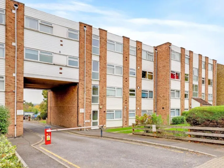
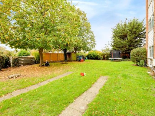
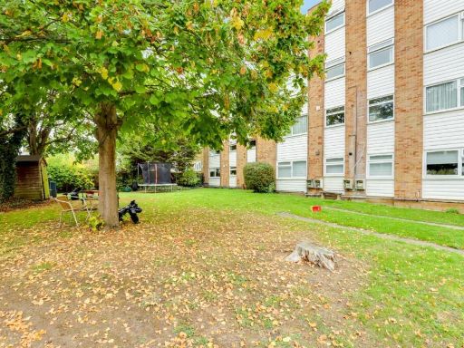
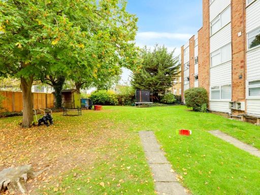
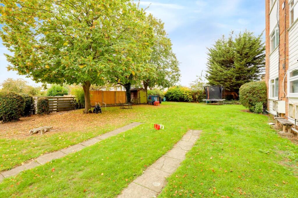
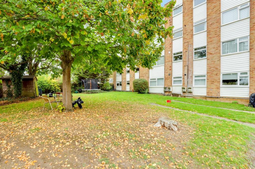
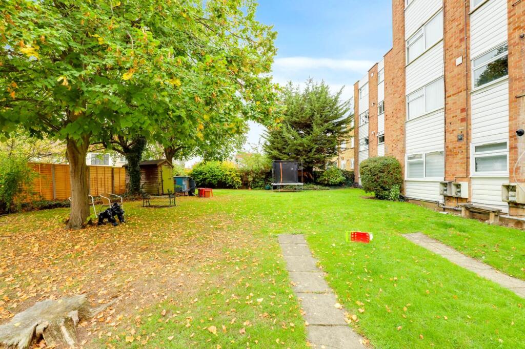
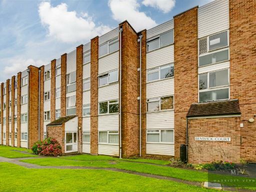
- Purpose-built mid-20th century apartment block accessed via a vehicular archway with secure gated parking beyond. The listing appears to be for a one-bedroom flat within a low-rise (3–4 storey) brick and cladding block. External communal grounds comprise a small front lawn and hedging with limited on-site parking. The building is typical of suburban outer-London stock — economical construction, communal entrance and stairwell access. The property is likely a small/average-sized one-bedroom flat suitable for first-time buyers or buy-to-let investors. Location offers suburban views and immediate access to local roads; no private garden is visible. Overall asset size is that of a flat within a medium-sized block; condition externally appears well maintained but architectural features are basic and functional.
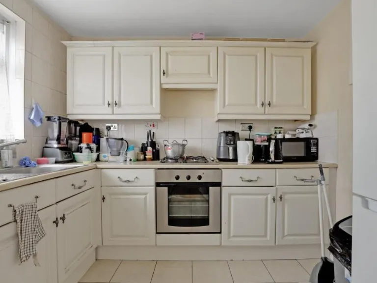
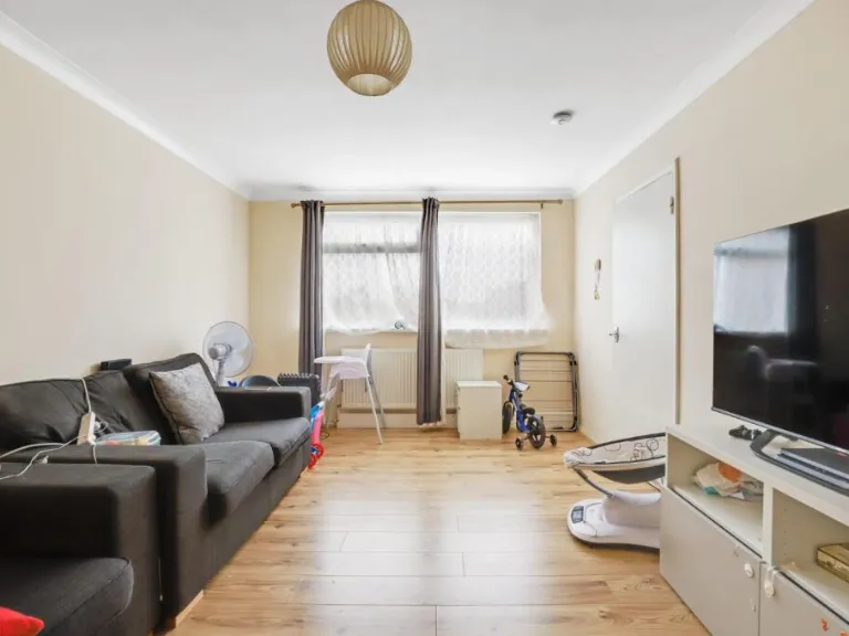
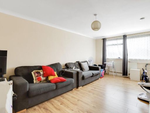
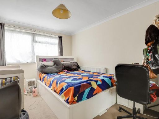
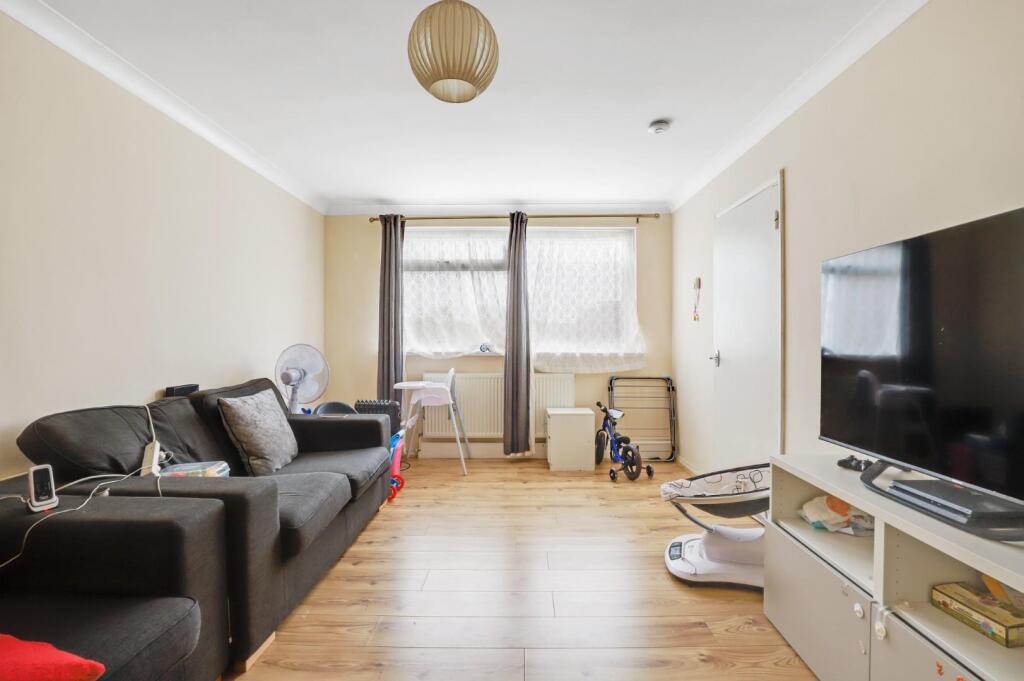
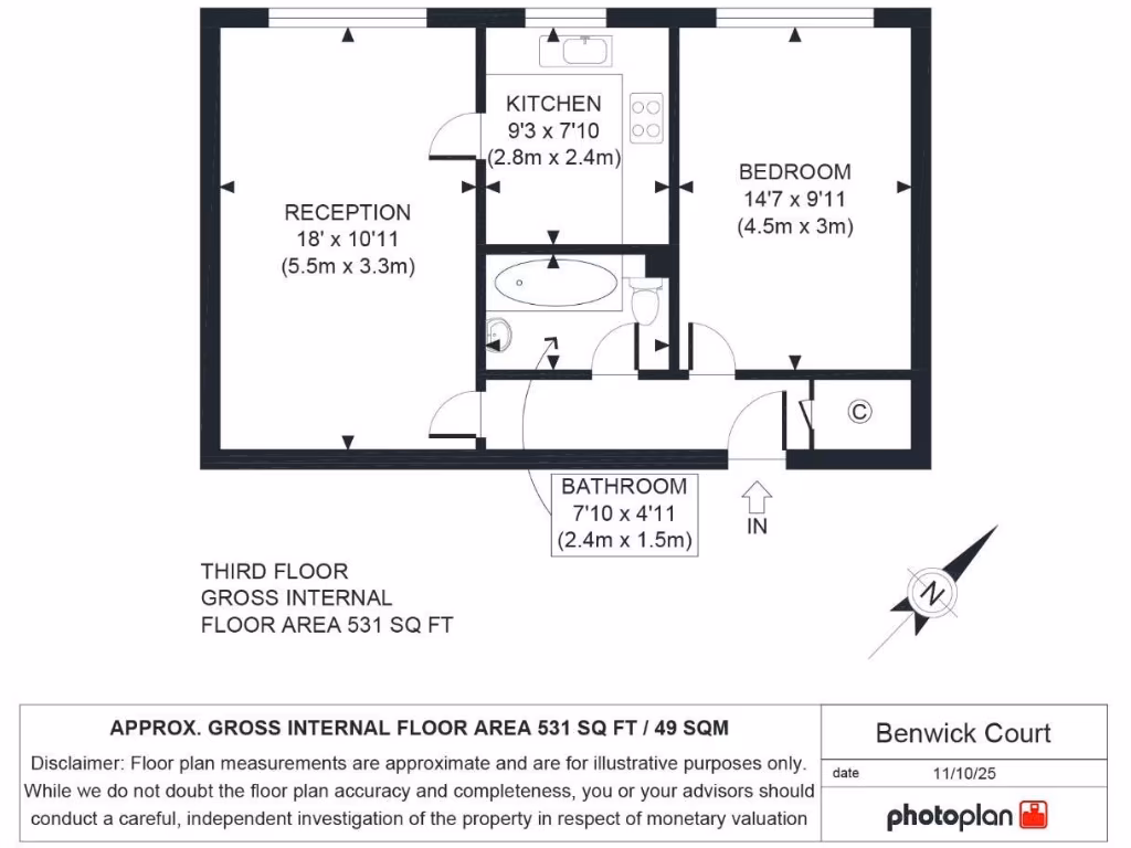
- Third-floor one-bedroom apartment in Benwick Court, Penge. Gross internal area approximately 531 sq ft. The accommodation comprises a reception room (approx. 18' x 10'11"), double bedroom (approx. 14'7" x 9'11"), separate kitchen (approx. 9'3" x 7'10") and family bathroom (approx. 7'10" x 4'11"). Urban location close to Anerley/Penge with nearby amenities and transport links; Crystal Palace Park is within easy reach. No private garden is apparent; the property is a flat within a mid-rise residential block. Overall the unit is a compact, well-proportioned city apartment suitable for a single occupant or couple, offering average internal space for a one-bedroom flat and good local connectivity.
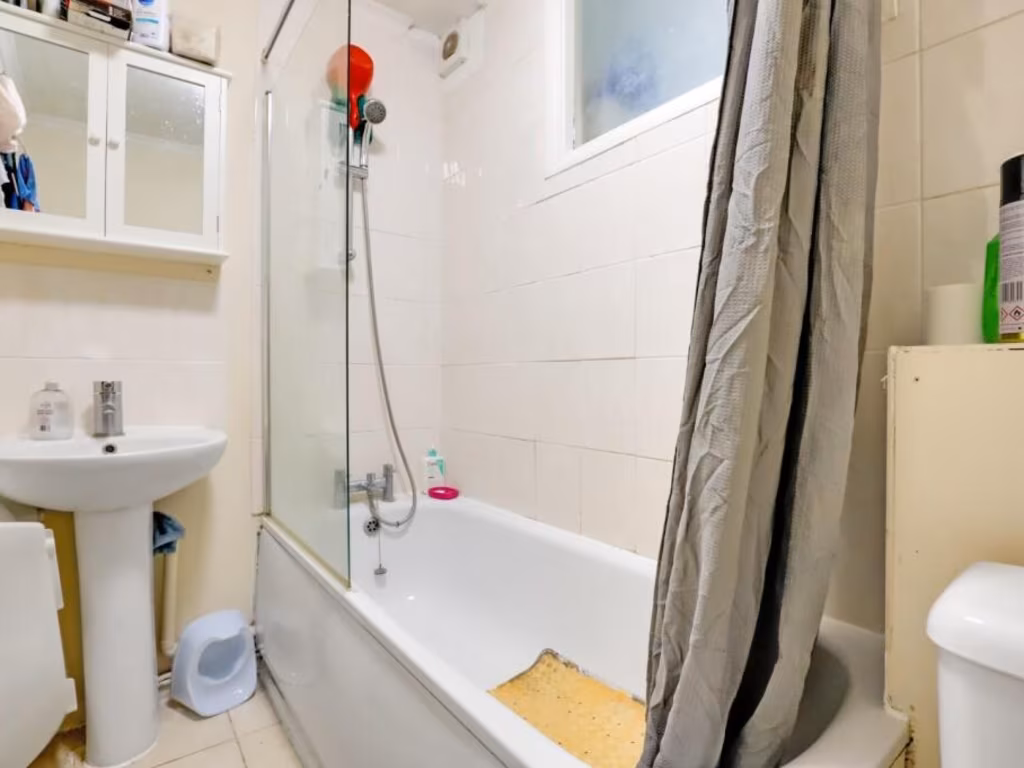
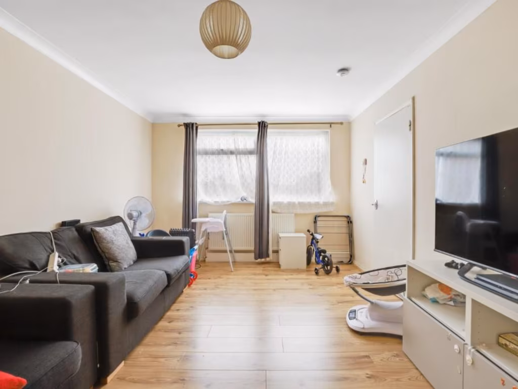
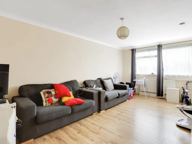
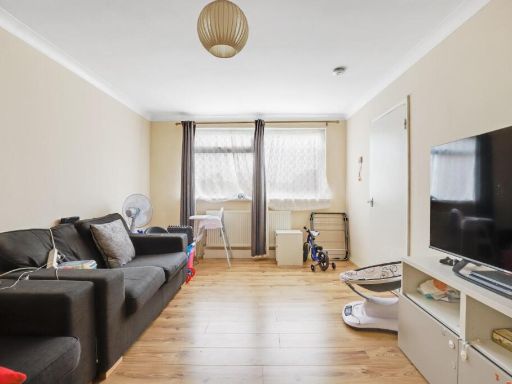
- Top-floor one-bedroom purpose-built flat in Benwick Court, Penge. Bright, neutrally decorated accommodation with a spacious lounge (approximately 18 ft), double master bedroom, fitted kitchen with white base and wall units and generous counter space, and a three-piece bathroom including a bath with partly tiled walls. Leasehold apartment in a well-run low-rise development with communal gardens and a maintained lawn to the rear. Good natural light throughout; straightforward, easy-to-maintain layout. Convenient for local amenities on Penge High Street and close to Penge West and Penge East stations; Winsford Gardens is adjacent. Features include entry phone, EPC rated D, council tax band B, and offered with no onward chain. Overall property size: small/average for a one-bedroom apartment (exact square footage not stated).
Image Descriptions
- apartment complex mid-century modern
- living room contemporary
Rooms
- RECEPTION:
- KITCHEN:
- BEDROOM:
- BATHROOM:
Textual Property Features
Detected Visual Features
- apartment complex
- brick construction
- mid-century modern
- residential building
- multi-story
- simple design
- balconies
- contemporary
- medium-sized living room
- large window
- natural light
- minimalist
- neutral walls
- modern lighting
EPC Details
- Fully double glazed
- Cavity wall, as built, no insulation (assumed)
- Boiler and radiators, mains gas
- Low energy lighting in 60% of fixed outlets
- (another dwelling below)
Nearby Schools
- Stewart Fleming Primary School
- Churchfields Primary School
- Balgowan Primary School
- Kings London
- Alexandra Junior School
- St Bartholomews's Church of England Primary School
- Kelvin Grove Primary School
- Sydenham School
- Monks Orchard Primary School
- Oasis Academy Arena
- Harris City Academy Crystal Palace
- Alexandra Infant School
- St John's Church of England Primary School
- Harris Girls Academy Bromley
- Harris Primary Academy Crystal Palace
- Sydenham High School, GDST
- Adamsrill Primary School
- Holy Trinity Church of England Primary School
- Marian Vian Primary School
- St Anthony's Roman Catholic Primary School
- James Dixon Primary School
- Haseltine Primary School
- Oasis Academy Ryelands
- Eden Park High School
- St Mark's Church of England Primary Academy
- Harris Primary Academy Kent House
- Forest Hill School
Nearest General Shops
- Id: 860516617
- Tags:
- Name: Co-operative
- Opening_hours: Mo-Su 07:00-22:00
- Shop: outdoor
- TagsNormalized:
- Lat: 51.4062569
- Lon: -0.0577467
- FullGeoHash: gcpuqwjznkuf
- PartitionGeoHash: gcpu
- Images:
- FoodStandards: null
- Distance: 331.4
,- Id: 1084648843
- Tags:
- Brand: Nissan
- Brand:wikidata: Q20165
- Building: yes
- Name: Nissan
- Shop: car
- TagsNormalized:
- Lat: 51.4109884
- Lon: -0.0550409
- FullGeoHash: gcpuqxpftqye
- PartitionGeoHash: gcpu
- Images:
- FoodStandards: null
- Distance: 267.4
,- Id: 963996542
- Tags:
- Addr:
- City: London
- Housenumber: 5
- Postcode: SE20 7AA
- Street: The Parade, Croydon Road
- Building: yes
- Name: United Pharmacy
- Opening_hours: Mo-Sa 09:00-19:00
- Shop: chemist
- TagsNormalized:
- Lat: 51.4091695
- Lon: -0.0588808
- FullGeoHash: gcpuqwv05gz3
- PartitionGeoHash: gcpu
- Images:
- FoodStandards: null
- Distance: 83.4
}
Nearest Grocery shops
- Id: 1066251194
- Tags:
- Brand: Best-one
- Brand:wikidata: Q4896532
- Building: yes
- Name: Best-one
- Shop: convenience
- TagsNormalized:
- Lat: 51.4124121
- Lon: -0.0541322
- FullGeoHash: gcpuqz2e48k0
- PartitionGeoHash: gcpu
- Images:
- FoodStandards: null
- Distance: 430.5
,- Id: 693728392
- Tags:
- Atm: yes
- Name: Co-operative Food
- Opening_hours: Mo-Su 07:00-22:00
- Shop: supermarket
- TagsNormalized:
- Lat: 51.4062571
- Lon: -0.0577434
- FullGeoHash: gcpuqwjznkzk
- PartitionGeoHash: gcpu
- Images:
- FoodStandards: null
- Distance: 331.4
,- Id: 1046557952
- Tags:
- Brand: Budgens
- Brand:wikidata: Q4985016
- Brand:wikipedia: en:Budgens
- Building: yes
- Name: Budgens
- Opening_hours: Mo-Su 07:00-22:00
- Shop: convenience
- TagsNormalized:
- Lat: 51.4091174
- Lon: -0.0589799
- FullGeoHash: gcpuqwtpcdj6
- PartitionGeoHash: gcpu
- Images:
- FoodStandards: null
- Distance: 90.9
}
Nearest Supermarkets
- Id: 14760316
- Tags:
- Brand: Tesco
- Brand:wikidata: Q487494
- Building: shop
- Contact:
- Website: https://www.tesco.com/store-locator/beckenham/croydon-rd
- Name: Tesco
- Name:fa: تسکو
- Shop: supermarket
- TagsNormalized:
- Lat: 51.396439
- Lon: -0.0501575
- FullGeoHash: gcpuqu7mznxu
- PartitionGeoHash: gcpu
- Images:
- FoodStandards: null
- Distance: 1515.8
,- Id: 23945692
- Tags:
- Brand: Sainsbury's
- Brand:wikidata: Q152096
- Building: shop
- Name: Sainsbury's
- Shop: supermarket
- TagsNormalized:
- sainsburys
- shop
- supermarket
- Lat: 51.4126588
- Lon: -0.0515861
- FullGeoHash: gcpuqz6kmynx
- PartitionGeoHash: gcpu
- Images:
- FoodStandards: null
- Distance: 568.9
,- Id: 172844248
- Tags:
- Brand: ALDI
- Brand:wikidata: Q41171672
- Brand:wikipedia: en:Aldi
- Building: retail
- Contact:
- Website: https://stores.aldi.co.uk/anerley/97-croydon-road
- Name: ALDI
- Name:fa: آلدی
- Opening_hours: Mo-Sa 08:00-22:00; Su 10:00-16:00
- Shop: supermarket
- TagsNormalized:
- aldi
- retail
- supermarket
- shop
- Lat: 51.4084625
- Lon: -0.0590019
- FullGeoHash: gcpuqwt5cpuz
- PartitionGeoHash: gcpu
- Images:
- FoodStandards: null
- Distance: 125.6
}
Nearest Religious buildings
- Id: 878914351
- Tags:
- Amenity: place_of_worship
- Building: church
- Denomination: anglican
- Name: Saint Michael's Beckenham Church
- Religion: christian
- Wikidata: Q105087407
- TagsNormalized:
- place of worship
- church
- anglican
- christian
- Lat: 51.4077145
- Lon: -0.0518983
- FullGeoHash: gcpuqy6pwstc
- PartitionGeoHash: gcpu
- Images:
- FoodStandards: null
- Distance: 435.5
,- Id: 881958371
- Tags:
- Addr:
- Housenumber: 197
- Street: Anerley Road
- Amenity: place_of_worship
- Building: church
- Denomination: anglican
- Name: Christ Church
- Postal_code: SE20 8ER
- Religion: christian
- Url: http://www.anerleyteamministry.org.uk/
- Wikidata: Q105087464
- TagsNormalized:
- place of worship
- church
- anglican
- christian
- Lat: 51.4096874
- Lon: -0.0613725
- FullGeoHash: gcpuqwg71um6
- PartitionGeoHash: gcpu
- Images:
- FoodStandards: null
- Distance: 260.7
,- Id: 309545199
- Tags:
- Amenity: place_of_worship
- Denomination: catholic
- Name: St Anthony of Padua Catholic Church
- Religion: christian
- TagsNormalized:
- place of worship
- catholic
- church
- christian
- Lat: 51.4098843
- Lon: -0.0596289
- FullGeoHash: gcpuqwus6913
- PartitionGeoHash: gcpu
- Images:
- FoodStandards: null
- Distance: 153
}
Nearest Medical buildings
- Id: 6391756280
- Tags:
- Amenity: clinic
- Healthcare: clinic
- Name: Oaks Park Medical Centre
- TagsNormalized:
- Lat: 51.4131837
- Lon: -0.0632096
- FullGeoHash: gcpuqx3zx05d
- PartitionGeoHash: gcpu
- Images:
- FoodStandards: null
- Distance: 582.7
,- Id: 9547252864
- Tags:
- Amenity: dentist
- Healthcare: dentist
- TagsNormalized:
- Lat: 51.4110433
- Lon: -0.0654154
- FullGeoHash: gcpuqx0759nd
- PartitionGeoHash: gcpu
- Images:
- FoodStandards: null
- Distance: 572.7
,- Id: 386950388
- Tags:
- Addr:
- Housenumber: 174
- Street: Croydon Road
- Amenity: pharmacy
- Building: yes
- Building:levels: 4
- Name: TT Pharmacy
- TagsNormalized:
- Lat: 51.4066323
- Lon: -0.0643169
- FullGeoHash: gcpuqw31m6cf
- PartitionGeoHash: gcpu
- Images:
- FoodStandards: null
- Distance: 543.7
,- Id: 7359687539
- Tags:
- Amenity: doctors
- Healthcare: doctor
- Name: Anerley Surgery
- TagsNormalized:
- doctor
- doctors
- health
- healthcare
- surgery
- Lat: 51.4090535
- Lon: -0.0606243
- FullGeoHash: gcpuqwez7q5j
- PartitionGeoHash: gcpu
- Images:
- FoodStandards: null
- Distance: 205
}
Nearest Airports
- Id: 260720166
- Tags:
- Aerodrome: international
- Aeroway: aerodrome
- Alt_name: Gatwick Airport
- Ele: 62
- Iata: LGW
- Icao: EGKK
- Internet_access: wlan
- Internet_access:fee: no
- Internet_access:ssid: Gatwick FREE Wi-Fi
- Name: London Gatwick Airport
- Operator: Gatwick Airport Limited
- Ref: LGW
- Website: https://www.gatwickairport.com/
- Wikidata: Q8703
- Wikipedia: en:Gatwick Airport
- TagsNormalized:
- airport
- international airport
- Lat: 51.1540917
- Lon: -0.1883773
- FullGeoHash: gcpg58qf4mzd
- PartitionGeoHash: gcpg
- Images:
- FoodStandards: null
- Distance: 29791.5
,- Id: 121158889
- Tags:
- Aerodrome: continental
- Aeroway: aerodrome
- Fhrs:
- Authority: City of London Corporation
- Iata: LCY
- Icao: EGLC
- Name: London City Airport
- Operator: London City Airport Limited
- Ref: LCY
- Website: https://www.londoncityairport.com/
- Wikidata: Q8982
- Wikipedia: en:London City Airport
- TagsNormalized:
- airport
- continental airport
- Lat: 51.5042658
- Lon: 0.0539987
- FullGeoHash: u10j10p64702
- PartitionGeoHash: u10j
- Images:
- FoodStandards: null
- Distance: 13097
,- Id: 14001268
- Tags:
- Access: yes
- Aerodrome: international
- Aerodrome:type: public
- Aeroway: aerodrome
- Alt_name: London Heathrow
- Alt_name_2: London Heathrow Airport
- Ele: 25
- Iata: LHR
- Icao: EGLL
- Int_name: Heathrow Airport
- Name: London Heathrow Airport
- Note: area still approx
- Old_name: London Airport
- Operator: Heathrow Airport Limited
- Rank_aci:
- Ref: LHR
- Short_name: Heathrow
- Type: multipolygon
- Website: https://www.heathrow.com/
- Wikidata: Q8691
- Wikipedia: en:Heathrow Airport
- TagsNormalized:
- airport
- international airport
- Lat: 51.4677522
- Lon: -0.4547736
- FullGeoHash: gcpsv9kv7h2h
- PartitionGeoHash: gcps
- Images:
- FoodStandards: null
- Distance: 28282.4
}
Nearest Leisure Facilities
- Id: 40217262
- Tags:
- Building: yes
- Leisure: sports_centre
- Name: Crystal Palace Indoor Bowling Club
- Sport: bowls
- TagsNormalized:
- sports
- sports centre
- leisure
- bowling
- club
- bowls
- Lat: 51.4106364
- Lon: -0.0626768
- FullGeoHash: gcpuqx42et0z
- PartitionGeoHash: gcpu
- Images:
- FoodStandards: null
- Distance: 379.7
,- Id: 675169353
- Tags:
- Leisure: pitch
- Sport: bowls
- TagsNormalized:
- Lat: 51.4109394
- Lon: -0.0540372
- FullGeoHash: gcpuqz0dkvdz
- PartitionGeoHash: gcpu
- Images:
- FoodStandards: null
- Distance: 315.9
,- Id: 675174670
- Tags:
- TagsNormalized:
- Lat: 51.4105765
- Lon: -0.0559007
- FullGeoHash: gcpuqxp236j6
- PartitionGeoHash: gcpu
- Images:
- FoodStandards: null
- Distance: 193.6
,- Id: 675174671
- Tags:
- Access: private
- Leisure: garden
- TagsNormalized:
- Lat: 51.4104607
- Lon: -0.0561002
- FullGeoHash: gcpuqwzpsu2x
- PartitionGeoHash: gcpu
- Images:
- FoodStandards: null
- Distance: 174.9
,- Id: 26538012
- Tags:
- Barrier: fence
- Leisure: park
- Name: Winsford Gardens
- Website: https://www.pengegreengym.org.uk/
- Wikidata: Q47351213
- TagsNormalized:
- Lat: 51.4093594
- Lon: -0.0563633
- FullGeoHash: gcpuqwycnxhq
- PartitionGeoHash: gcpu
- Images:
- FoodStandards: null
- Distance: 92.6
}
Nearest Tourist attractions
- Id: 293536391
- Tags:
- Addr:
- City: London
- Housenumber: 24
- Postcode: SE19 2XE
- Street: Fox Hill
- Name: Fox Hill Bed and Breakfast
- Tourism: guest_house
- Website: www.foxhill-bandb.co.uk
- TagsNormalized:
- Lat: 51.4147408
- Lon: -0.0780868
- FullGeoHash: gcpuqpz0s6q7
- PartitionGeoHash: gcpu
- Images:
- FoodStandards: null
- Distance: 1541.7
,- Id: 670997038
- Tags:
- Dog: no
- Tourism: picnic_site
- TagsNormalized:
- Lat: 51.4194119
- Lon: -0.0661021
- FullGeoHash: gcpuw2xgg9ne
- PartitionGeoHash: gcpu
- Images:
- FoodStandards: null
- Distance: 1273.2
,- Id: 672676426
- Tags:
- Operator: Brown & Green
- Tourism: picnic_site
- TagsNormalized:
- Lat: 51.4189368
- Lon: -0.0640505
- FullGeoHash: gcpuw8935883
- PartitionGeoHash: gcpu
- Images:
- FoodStandards: null
- Distance: 1165.5
}
Nearest Hotels
- Id: 539644959
- Tags:
- Addr:
- City: London Borough of Bromley
- Housename: Bromley Court Hotel
- Postcode: BR1 4JD
- Street: Coniston Road
- Building: yes
- Fhrs:
- Name: Bromley Court Hotel
- Phone: +44 20 8461 8600
- Source:
- Tourism: hotel
- TagsNormalized:
- Lat: 51.4167004
- Lon: 0.0018655
- FullGeoHash: u10h8017grxh
- PartitionGeoHash: u10h
- Images:
- FoodStandards: null
- Distance: 4212.4
,- Id: 32349145
- Tags:
- Addr:
- City: London
- Housenumber: 122
- Postcode: SE19 2UG
- Street: Church Road
- Suburb: Upper Norwood
- Building: yes
- Building:levels: 1
- Fhrs:
- Authority: Croydon
- Id: 1867
- Name: Queens Hotel
- Phone: +44 20 8653 6622
- Tourism: hotel
- Website: www.euroqueenshotel.com
- TagsNormalized:
- Lat: 51.415216
- Lon: -0.0835473
- FullGeoHash: gcpuqpg5m4yw
- PartitionGeoHash: gcpu
- Images:
- FoodStandards: null
- Distance: 1913
,- Id: 1084648842
- Tags:
- Brand: Travelodge
- Brand:wikidata: Q9361374
- Building: yes
- Internet_access: wlan
- Internet_access:fee: customers
- Internet_access:ssid: Travelodge WiFi
- Name: Travelodge
- Tourism: hotel
- TagsNormalized:
- Lat: 51.4106898
- Lon: -0.0551484
- FullGeoHash: gcpuqxpbfznq
- PartitionGeoHash: gcpu
- Images:
- FoodStandards: null
- Distance: 238.8
}
Tags
- apartment complex
- brick construction
- mid-century modern
- residential building
- multi-story
- simple design
- balconies
- contemporary
- medium-sized living room
- large window
- natural light
- minimalist
- neutral walls
- modern lighting
Local Market Stats
- Average Price/sqft: £539
- Avg Income: £55500
- Rental Yield: 4.7%
- Social Housing: 29%
- Planning Success Rate: 71%
AirBnB Data
- 1km average: £97/night
- Listings in 1km: 11
Similar Properties
 2 bedroom flat for sale in Croydon Road, London, SE20 — £290,000 • 2 bed • 1 bath • 622 ft²
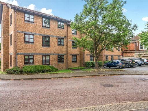 1 bedroom flat for sale in Tarragon Grove, Sydenham, London, SE26 — £250,000 • 1 bed • 1 bath • 452 ft²
 1 bedroom flat for sale in Croydon Road, London, SE20 — £275,000 • 1 bed • 1 bath • 465 ft²
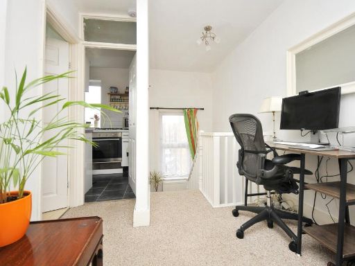 1 bedroom flat for sale in Croydon Road, London, SE20 — £200,000 • 1 bed • 1 bath • 352 ft²
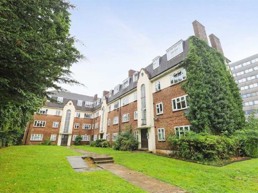 2 bedroom flat for sale in Avenue Road, Penge, London, SE20 — £275,000 • 2 bed • 1 bath • 511 ft²
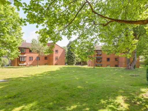 2 bedroom flat for sale in Ashurst Close, Anerley, London, SE20 — £275,000 • 2 bed • 1 bath • 602 ft²
Meta
- {
"@context": "https://schema.org",
"@type": "Residence",
"name": "1 bedroom flat for sale in Croydon Road, Anerley, London, S…",
"description": "",
"url": "https://propertypiper.co.uk/property/cba01ab3-160f-4a01-bb48-162b6f5ffd4c",
"image": "https://image-a.propertypiper.co.uk/a52d10e6-ace2-40b7-9809-49216cf7773a-1024.jpeg",
"address": {
"@type": "PostalAddress",
"streetAddress": "BENWICK COURT FLAT 26 CROYDON ROAD LONDON",
"postalCode": "SE20 7SS",
"addressLocality": "Bromley",
"addressRegion": "Lewisham West and Penge",
"addressCountry": "England"
},
"geo": {
"@type": "GeoCoordinates",
"latitude": 51.409236854147935,
"longitude": -0.0576832166963904
},
"numberOfRooms": 1,
"numberOfBathroomsTotal": 1,
"floorSize": {
"@type": "QuantitativeValue",
"value": 531,
"unitCode": "FTK"
},
"offers": {
"@type": "Offer",
"price": 205000,
"priceCurrency": "GBP",
"availability": "https://schema.org/InStock"
},
"additionalProperty": [
{
"@type": "PropertyValue",
"name": "Feature",
"value": "apartment complex"
},
{
"@type": "PropertyValue",
"name": "Feature",
"value": "brick construction"
},
{
"@type": "PropertyValue",
"name": "Feature",
"value": "mid-century modern"
},
{
"@type": "PropertyValue",
"name": "Feature",
"value": "residential building"
},
{
"@type": "PropertyValue",
"name": "Feature",
"value": "multi-story"
},
{
"@type": "PropertyValue",
"name": "Feature",
"value": "simple design"
},
{
"@type": "PropertyValue",
"name": "Feature",
"value": "balconies"
},
{
"@type": "PropertyValue",
"name": "Feature",
"value": "contemporary"
},
{
"@type": "PropertyValue",
"name": "Feature",
"value": "medium-sized living room"
},
{
"@type": "PropertyValue",
"name": "Feature",
"value": "large window"
},
{
"@type": "PropertyValue",
"name": "Feature",
"value": "natural light"
},
{
"@type": "PropertyValue",
"name": "Feature",
"value": "minimalist"
},
{
"@type": "PropertyValue",
"name": "Feature",
"value": "neutral walls"
},
{
"@type": "PropertyValue",
"name": "Feature",
"value": "modern lighting"
}
]
}
High Res Floorplan Images
Compatible Floorplan Images
FloorplanImages Thumbnail