HR3 5SX - Land for sale in Middlewood, Dorstone, Hereford, HR3
View on Property Piper
Land for sale in Middlewood, Dorstone, Hereford, HR3
Property Details
- Price: £300000
- Bedrooms: 1
- Bathrooms: 1
- Property Type: undefined
- Property SubType: undefined
Brochure Descriptions
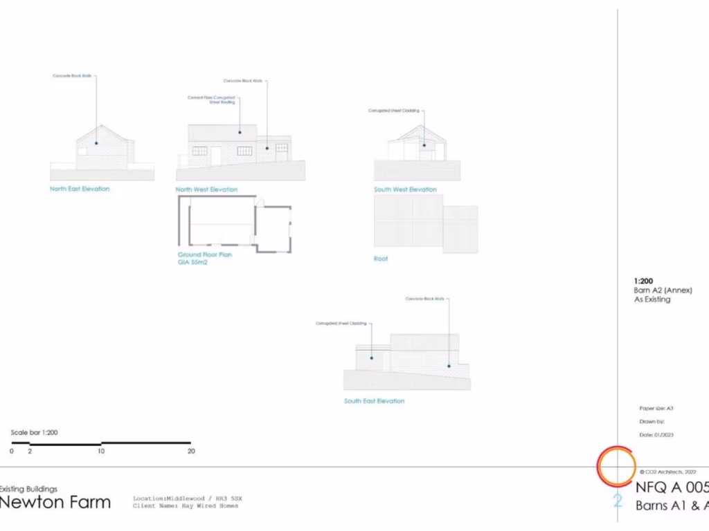
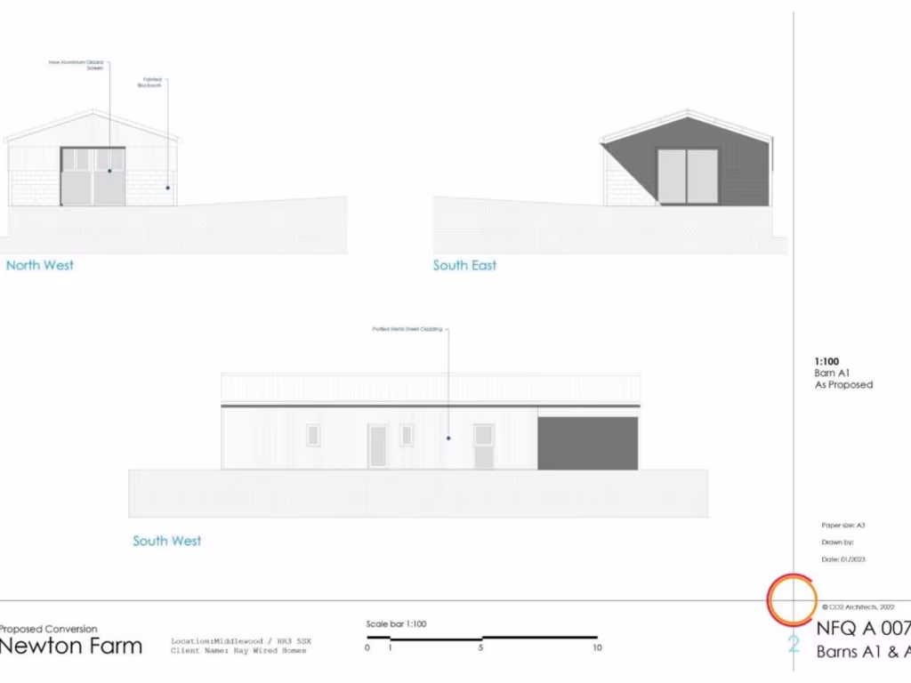
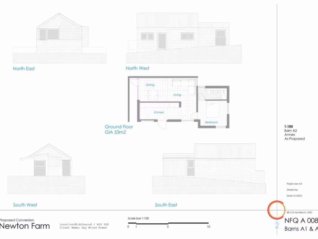
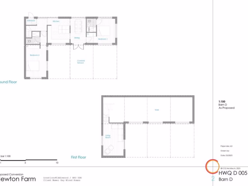
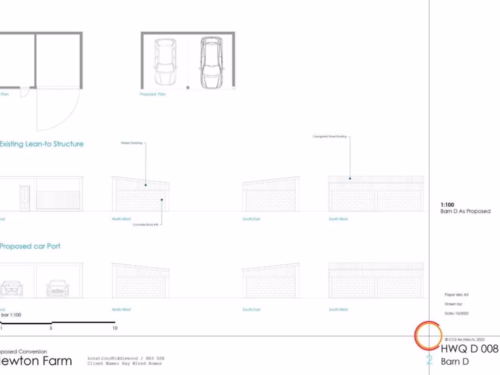
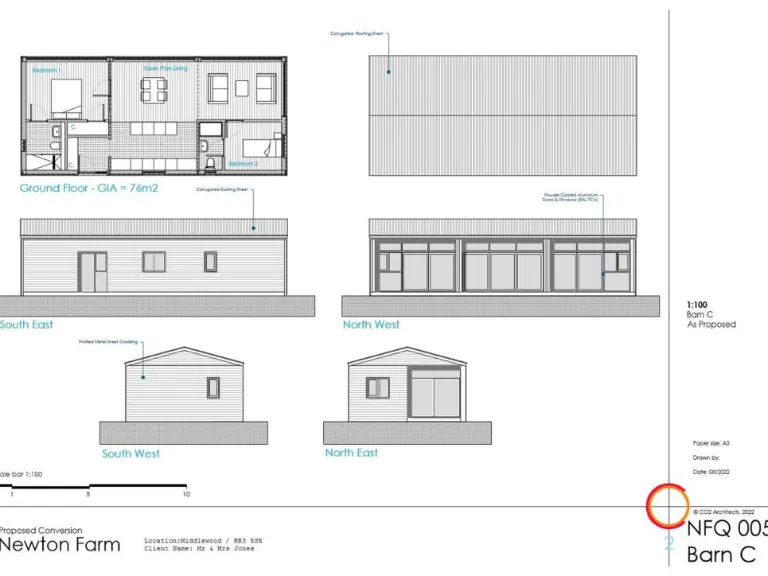
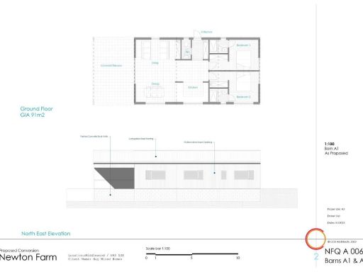
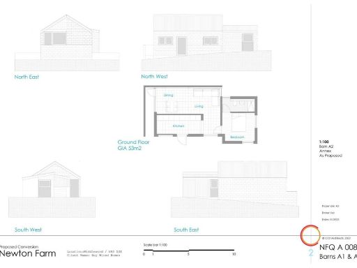
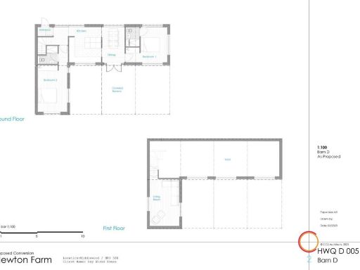
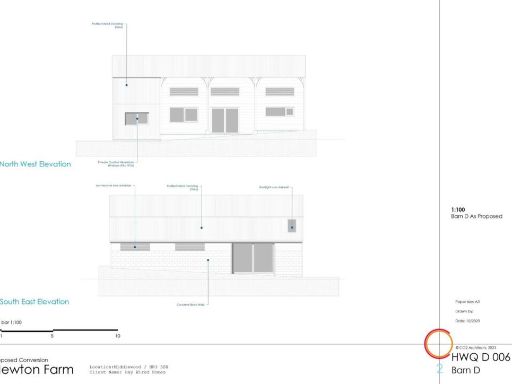
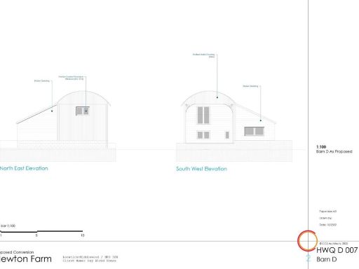
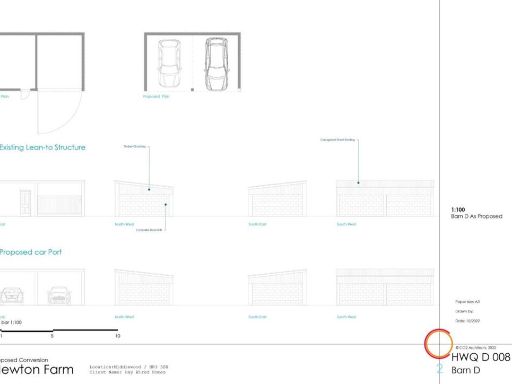
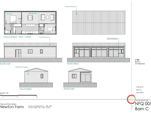
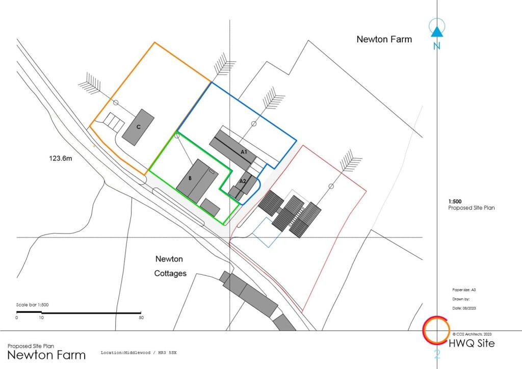
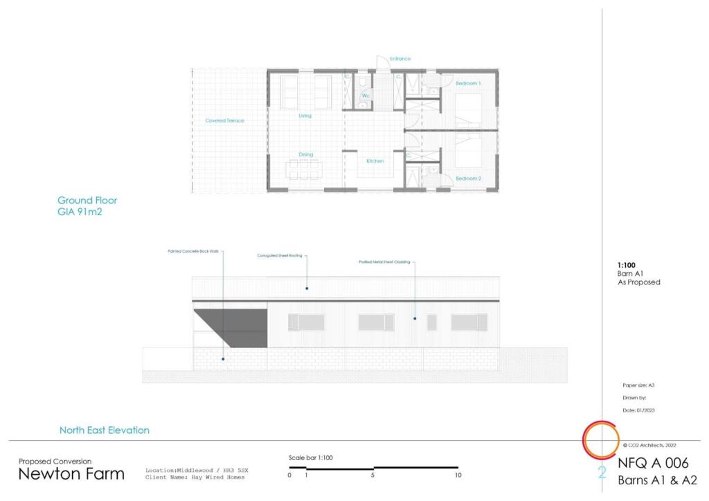
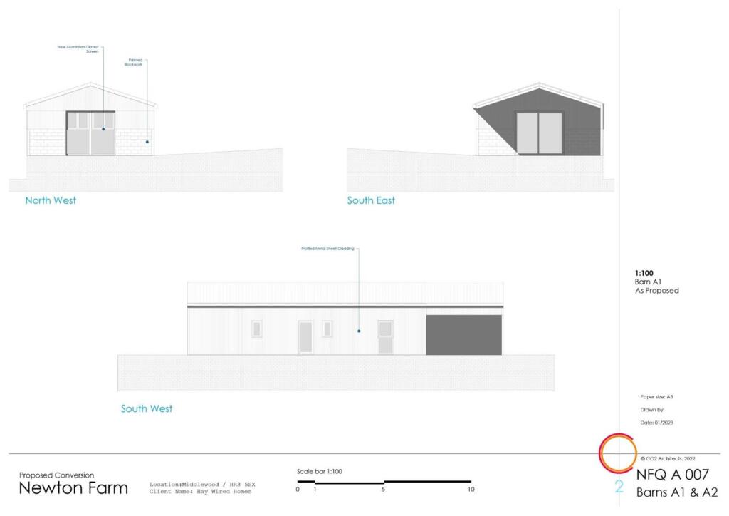
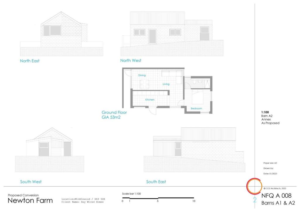
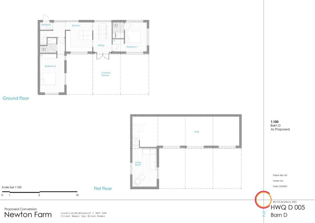
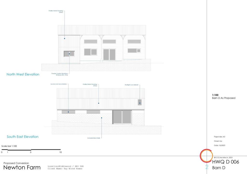
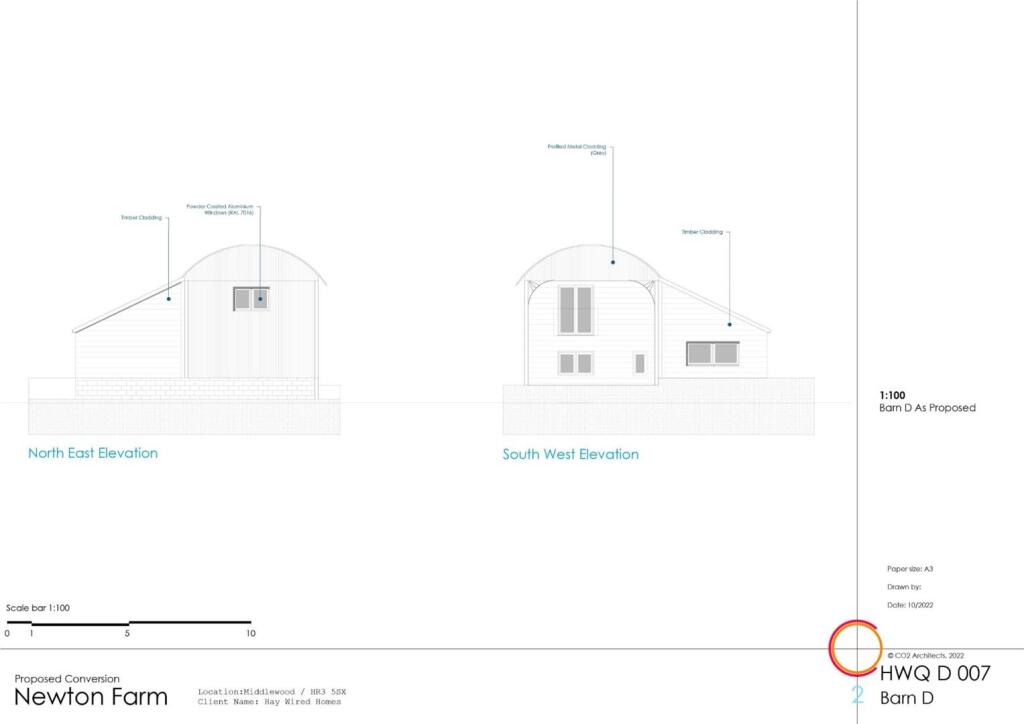
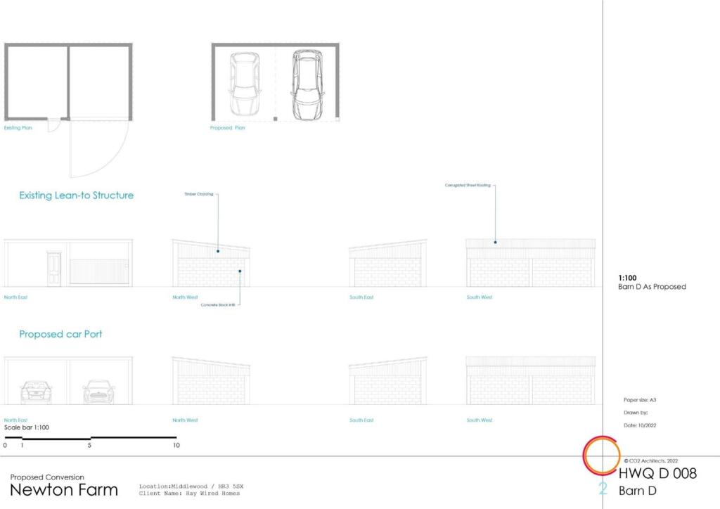
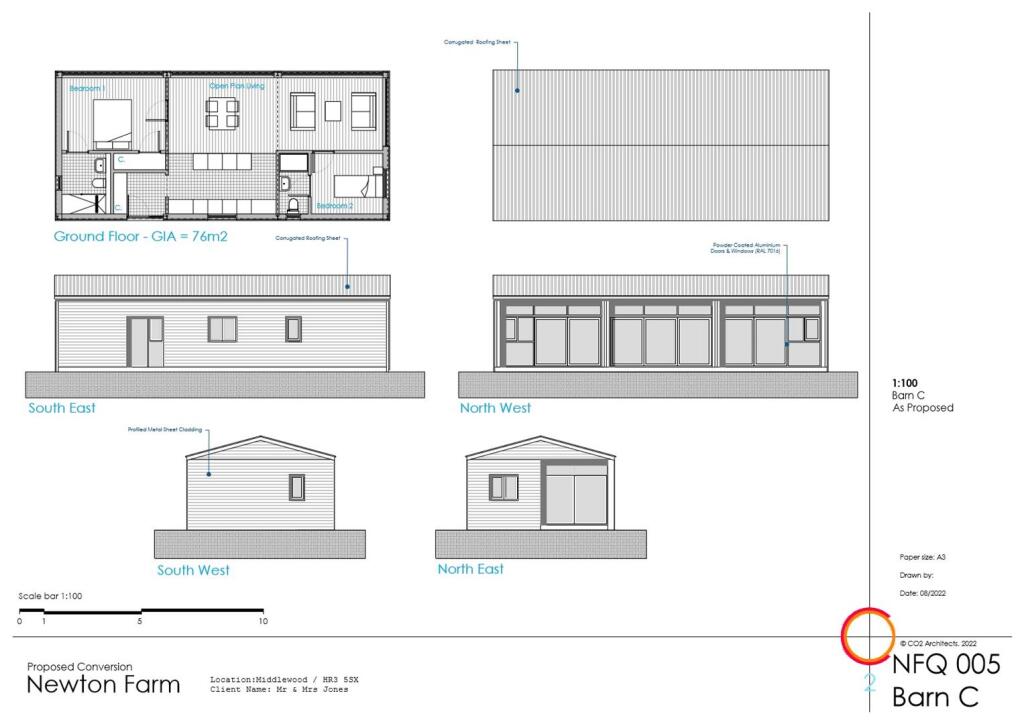
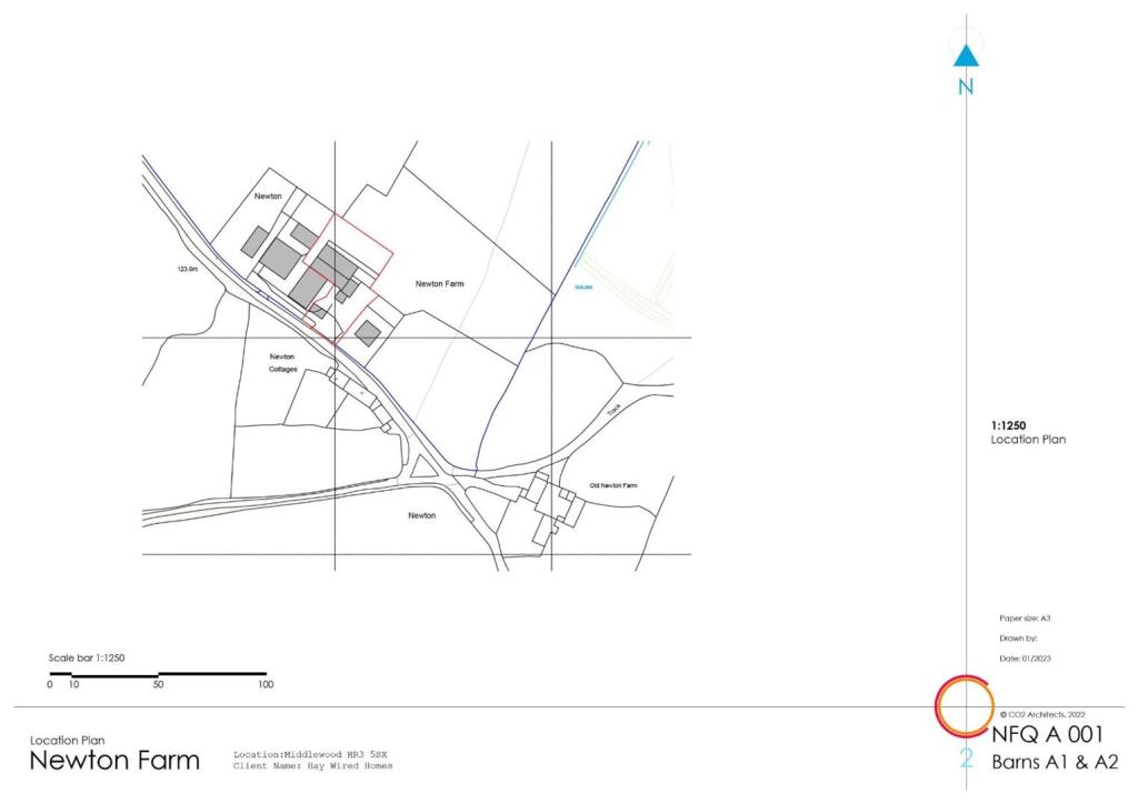
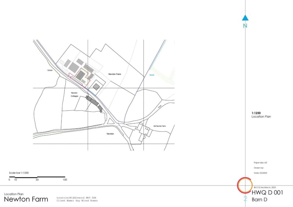
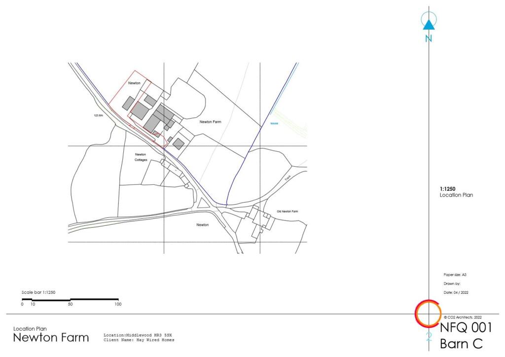
- The property consists of multiple barn conversion plots located in a largely rural setting within Newton Farm. The surroundings appear to provide an open aspect with likely views of the countryside, given the rural location. Potential views may include pastoral landscapes and adjacent farm structures. The plot sizes seem average to large, providing ample space for residential development or recreational use. There are several distinct plots, suggesting the opportunity for multi-property development, highlighting a significant scale for potential accommodations.
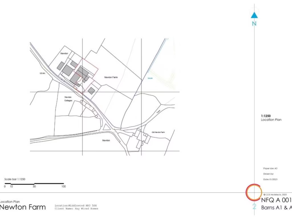
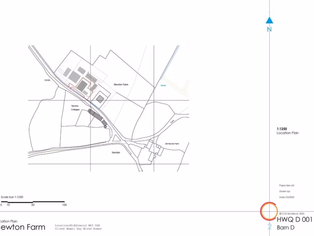
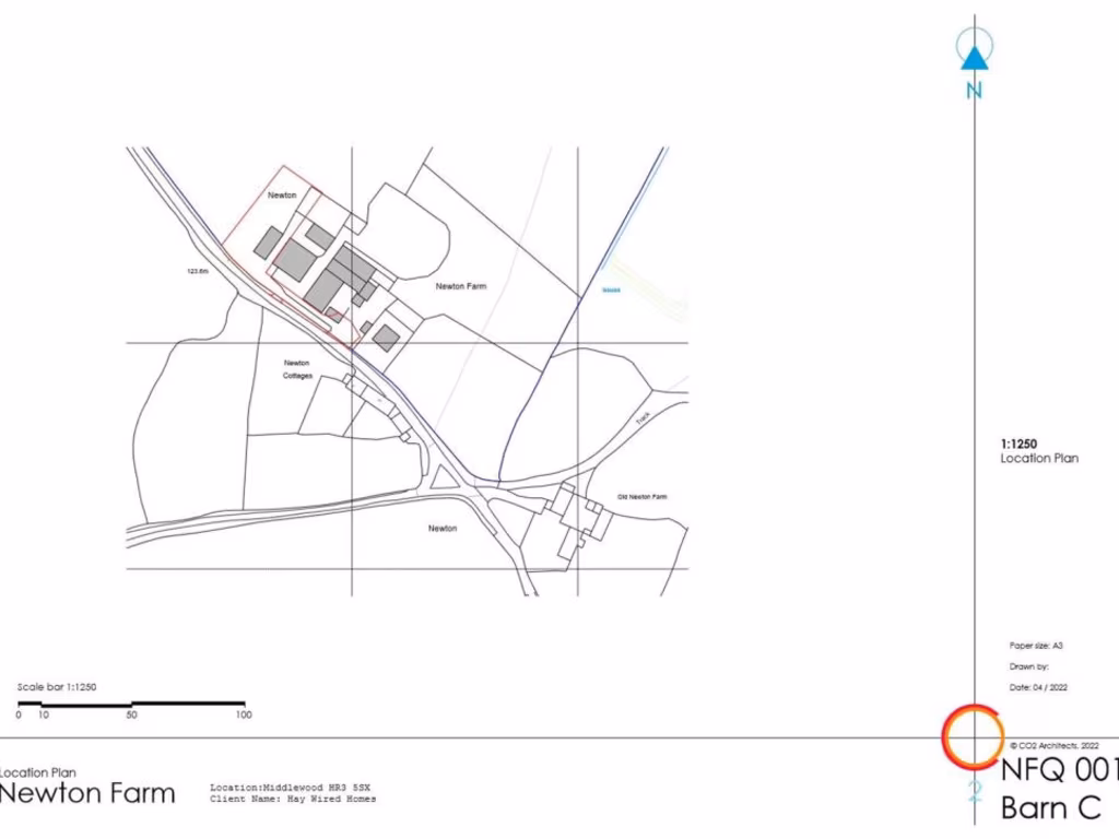
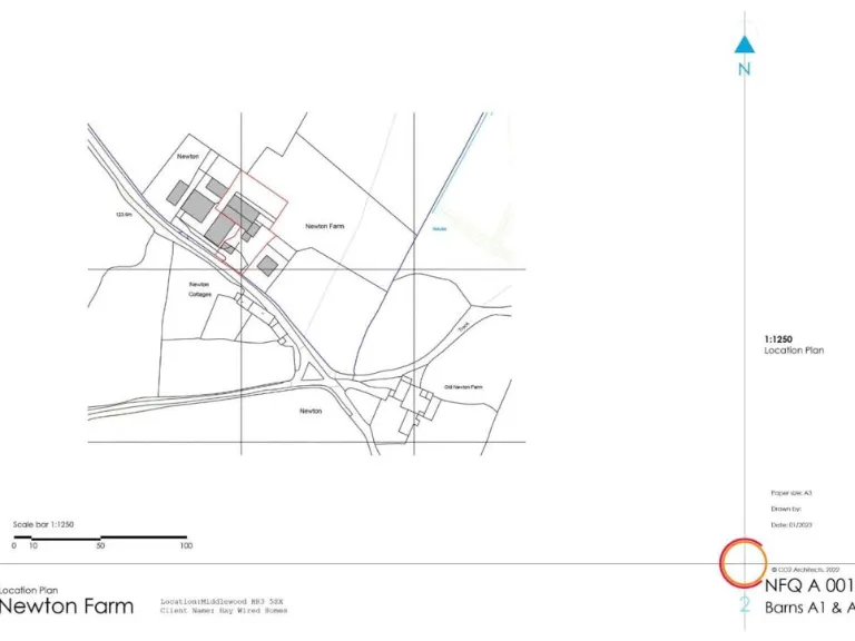
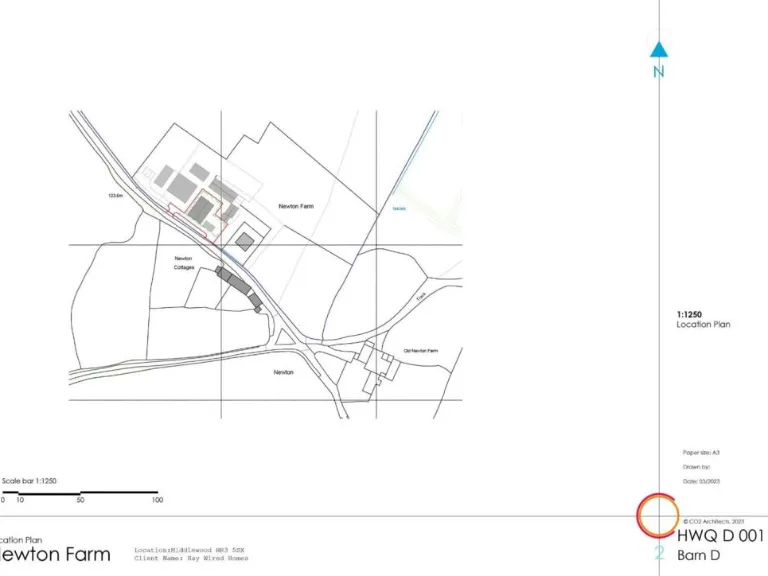
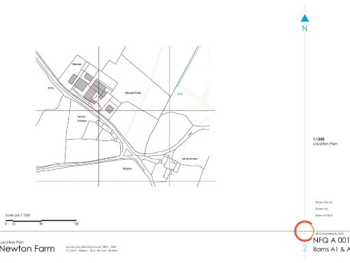
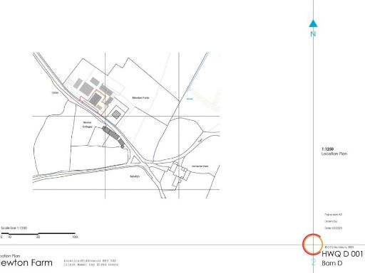
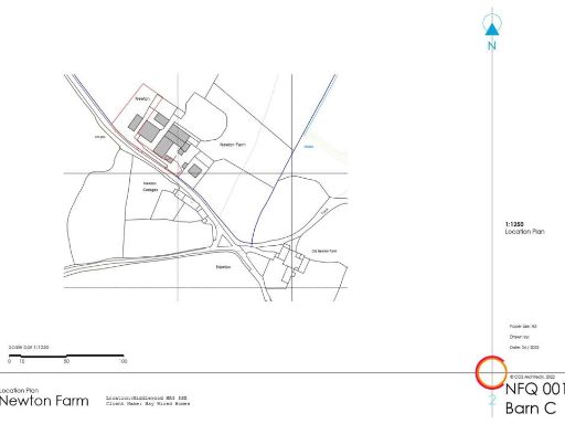
- Newton Farm is situated in a rural setting at Middlewood. The property appears to be of considerable size, indicating a farmstead or an agricultural holding. There are several outbuildings or barns within its boundary, offering extensive storage or agricultural usage. The land is likely expansive, suitable for farming or equestrian purposes, with clear demarcations on the plan suggesting distinct zones for varied uses. The farm might enjoy open countryside views, given its location away from urban centers, and offers a peaceful, pastoral environment with rich natural surroundings. The driveway and access paths are depicted, indicating ample space for parking and vehicular movement.
Image Descriptions
- property map farm cottages
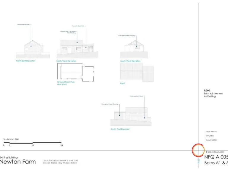
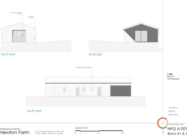
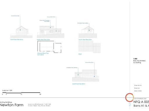
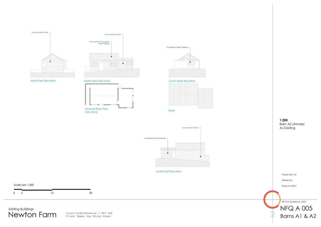
- property elevations and layout Contemporary
Textual Property Features
Detected Visual Features
- farm
- cottages
- Newton Farm
- Newton Cottages
- property map
- rural
- outbuildings
- land plot
- development opportunity
- contemporary
- concrete block walls
- elevations
- layout
- modern design
- roof
- small size
- 52 square meters
Nearby Schools
- Fairfield High School
- Eardisley CofE Primary School
- Peterchurch Primary School
- Almeley Primary School
- Clifford Primary School
- Staunton-on-Wye Endowed Primary School
Nearest Bars And Restaurants
- Id: 4933289672
- Tags:
- Amenity: restaurant
- Name: Off Grid Gourmet
- TagsNormalized:
- Lat: 52.1055267
- Lon: -3.0843948
- FullGeoHash: gcmb3vd08qht
- PartitionGeoHash: gcmb
- Images:
- FoodStandards: null
- Distance: 3738.5
,- Id: 7180827047
- Tags:
- Amenity: cafe
- Name: Dorstone's Front Room
- TagsNormalized:
- Lat: 52.0688305
- Lon: -3.002438
- FullGeoHash: gcmb5wvdyjeb
- PartitionGeoHash: gcmb
- Images:
- FoodStandards: null
- Distance: 3272
,- Id: 769254947
- Tags:
- Amenity: pub
- Building: public
- Name: The Pandy Inn
- TagsNormalized:
- Lat: 52.0689507
- Lon: -3.0029753
- FullGeoHash: gcmb5wv79egm
- PartitionGeoHash: gcmb
- Images:
- FoodStandards: null
- Distance: 3236.8
,- Id: 187039280
- Tags:
- Amenity: pub
- Building: yes
- Name: The Sun Inn
- TagsNormalized:
- Lat: 52.1173535
- Lon: -3.0269107
- FullGeoHash: gcmb7pevefgg
- PartitionGeoHash: gcmb
- Images:
- FoodStandards: null
- Distance: 3125.6
,- Id: 864627578
- Tags:
- Amenity: restaurant
- Building: yes
- Name: The Castlefields
- Phone: +441497831554
- Source: Bing
- TagsNormalized:
- Lat: 52.1010066
- Lon: -3.0348202
- FullGeoHash: gcmb6uwn7ed4
- PartitionGeoHash: gcmb
- Images:
- FoodStandards: null
- Distance: 1248.1
}
Nearest General Shops
- Id: 1977972919
- Tags:
- Addr:
- City: Eardisley
- Postcode: HR3 6NX
- Street: Great Parton
- Name: The Orgasmic Cider Company
- Shop: beverages
- TagsNormalized:
- Lat: 52.1289045
- Lon: -2.9986792
- FullGeoHash: gcmbecb2vsne
- PartitionGeoHash: gcmb
- Images:
- FoodStandards: null
- Distance: 5040.1
,- Id: 841150048
- Tags:
- Building: yes
- Name: Whitney Garage
- Shop: car_repair
- Source: Bing
- TagsNormalized:
- garage
- car repair
- repair
- shop
- Lat: 52.1187915
- Lon: -3.0668757
- FullGeoHash: gcmb6pyvbwgt
- PartitionGeoHash: gcmb
- Images:
- FoodStandards: null
- Distance: 3850.9
,- Id: 791366595
- Tags:
- Name: Walkers Cottage
- Shop: yes
- Tourism: camp_site
- TagsNormalized:
- Lat: 52.1053141
- Lon: -3.0839302
- FullGeoHash: gcmb3v6r7nwc
- PartitionGeoHash: gcmb
- Images:
- FoodStandards: null
- Distance: 3699.4
}
Nearest Grocery shops
- Id: 333515212
- Tags:
- Addr:
- Postcode: HR3 6NJ
- Street: Church Street
- Building: yes
- Name: Central Stores
- Shop: convenience
- TagsNormalized:
- Lat: 52.1398572
- Lon: -3.0078239
- FullGeoHash: gcmbeecb8tgg
- PartitionGeoHash: gcmb
- Images:
- FoodStandards: null
- Distance: 5888.9
,- Id: 841150050
- Tags:
- Brand: Spar
- Brand:wikidata: Q610492
- Building: retail
- Name: Spar
- Shop: convenience
- Source: Bing
- TagsNormalized:
- spar
- retail
- convenience
- shop
- Lat: 52.1188558
- Lon: -3.0667617
- FullGeoHash: gcmb6pyy76bs
- PartitionGeoHash: gcmb
- Images:
- FoodStandards: null
- Distance: 3852.6
,- Id: 769244318
- Tags:
- Building: retail
- Shop: convenience
- Source: survey
- TagsNormalized:
- Lat: 52.0688184
- Lon: -3.0024407
- FullGeoHash: gcmb5wvdy53b
- PartitionGeoHash: gcmb
- Images:
- FoodStandards: null
- Distance: 3272.8
}
Nearest Supermarkets
- Id: 34233560
- Tags:
- Brand: Sainsbury's
- Brand:wikidata: Q152096
- Brand:wikipedia: en:Sainsbury's
- Building: yes
- Name: Sainsbury's
- Opening_hours: Mo-Sa 07:00-22:00; Su 10:00-16:00
- Shop: supermarket
- TagsNormalized:
- sainsburys
- supermarket
- shop
- Lat: 52.0547138
- Lon: -2.7248371
- FullGeoHash: gcq01urbdtyp
- PartitionGeoHash: gcq0
- Images:
- FoodStandards: null
- Distance: 21623.5
,- Id: 163571415
- Tags:
- Addr:
- City: Belmont
- Postcode: HR2 7XS
- Street: Abbotsmead Road
- Brand: Tesco
- Brand:wikidata: Q487494
- Brand:wikipedia: en:Tesco
- Building: yes
- Name: Tesco
- Opening_hours: Mo-Sa 06:00-23:49, Su 10:00-16:00
- Phone: +44 345 677 9350
- Shop: supermarket
- Website: https://www.tesco.com/store-locator/hereford/abbotsmead-rd
- TagsNormalized:
- Lat: 52.0423269
- Lon: -2.7400712
- FullGeoHash: gcq01dh8x8yu
- PartitionGeoHash: gcq0
- Images:
- FoodStandards: null
- Distance: 20907.6
,- Id: 187036803
- Tags:
- Brand: Co-op Food
- Brand:wikidata: Q3277439
- Brand:wikipedia: en:Co-op Food
- Building: retail
- Name: Co-op Food
- Shop: supermarket
- Wheelchair: yes
- TagsNormalized:
- co-op
- co-op food
- food
- retail
- supermarket
- shop
- Lat: 52.0799991
- Lon: -3.1229287
- FullGeoHash: gcmb2bvgyrrx
- PartitionGeoHash: gcmb
- Images:
- FoodStandards: null
- Distance: 6037.8
}
Nearest Religious buildings
- Id: 224995123
- Tags:
- Amenity: place_of_worship
- Building: church
- Denomination: anglican
- Heritage: 2
- Heritage:operator: Historic England
- Listed_status: Grade II*
- Name: Saint Faith
- Religion: christian
- Source: Bing; OS_Open_Data
- Source:name: Wikipedia
- Wikidata: Q17539522
- TagsNormalized:
- place of worship
- church
- anglican
- christian
- Lat: 52.0703091
- Lon: -3.0013979
- FullGeoHash: gcmb5xn7w35s
- PartitionGeoHash: gcmb
- Images:
- FoodStandards: null
- Distance: 3208.9
,- Id: 406990663
- Tags:
- Amenity: place_of_worship
- Building: church
- Denomination: anglican
- Name: St Michael and All Angels
- Religion: christian
- Wikidata: Q17538096
- TagsNormalized:
- place of worship
- church
- anglican
- christian
- Lat: 52.1166561
- Lon: -3.0256047
- FullGeoHash: gcmb7pscd2ce
- PartitionGeoHash: gcmb
- Images:
- FoodStandards: null
- Distance: 3069.1
,- Id: 818834032
- Tags:
- Amenity: place_of_worship
- Building: church
- Denomination: anglican
- Name: Holy Trinity
- Religion: christian
- Wikidata: Q26632239
- TagsNormalized:
- place of worship
- church
- anglican
- christian
- Lat: 52.087543
- Lon: -3.0662158
- FullGeoHash: gcmb64ppzvzb
- PartitionGeoHash: gcmb
- Images:
- FoodStandards: null
- Distance: 2078.6
}
Nearest Medical buildings
- Id: 645713282
- Tags:
- Amenity: hospital
- Building: yes
- Healthcare: hospital
- Name: Hay on Wye Medical Centre
- TagsNormalized:
- Lat: 52.0701957
- Lon: -3.1257457
- FullGeoHash: gcmb0z5fuu50
- PartitionGeoHash: gcmb
- Images:
- FoodStandards: null
- Distance: 6507.9
,- Id: 3424485860
- Tags:
- Amenity: pharmacy
- Healthcare: pharmacy
- Name: R M Jones Pharmacy
- Source: GPS Survey
- Toilets:
- Wheelchair: yes
- TagsNormalized:
- Lat: 52.0745122
- Lon: -3.1258366
- FullGeoHash: gcmb0zgu48xm
- PartitionGeoHash: gcmb
- Images:
- FoodStandards: null
- Distance: 6368.9
,- Id: 645719112
- Tags:
- Amenity: dentist
- Building: yes
- Healthcare: dentist
- Name: Hay on Wye Dental Centre
- Source: GPS Survey
- Website: https://www.hay-on-wye-dentalcentre.co.uk/
- TagsNormalized:
- dentist
- health
- healthcare
- dental
- Lat: 52.0733133
- Lon: -3.1237588
- FullGeoHash: gcmb0ztm51ht
- PartitionGeoHash: gcmb
- Images:
- FoodStandards: null
- Distance: 6269.9
,- Id: 3522146367
- Tags:
- Amenity: dentist
- Healthcare: dentist
- Name: River Wye Dental Care
- Source: GPS Survey
- TagsNormalized:
- dentist
- health
- healthcare
- dental
- river
- Lat: 52.0734841
- Lon: -3.1233336
- FullGeoHash: gcmb0ztwj118
- PartitionGeoHash: gcmb
- Images:
- FoodStandards: null
- Distance: 6236.6
}
Nearest Leisure Facilities
- Id: 1081795168
- Tags:
- TagsNormalized:
- Lat: 52.0708568
- Lon: -3.0030276
- FullGeoHash: gcmb5xjq8rhr
- PartitionGeoHash: gcmb
- Images:
- FoodStandards: null
- Distance: 3085.8
,- Id: 801288294
- Tags:
- Landuse: meadow
- Source: bing
- Sport: equestrian
- TagsNormalized:
- Lat: 52.0709518
- Lon: -3.0163643
- FullGeoHash: gcmb5r5x38gy
- PartitionGeoHash: gcmb
- Images:
- FoodStandards: null
- Distance: 2489.8
,- Id: 801288295
- Tags:
- Leisure: pitch
- Source: bing
- Sport: equestrian
- TagsNormalized:
- pitch
- leisure
- equestrian
- sports
- Lat: 52.0714155
- Lon: -3.0175273
- FullGeoHash: gcmb5r69yx2s
- PartitionGeoHash: gcmb
- Images:
- FoodStandards: null
- Distance: 2403.8
,- Id: 937982860
- Tags:
- Leisure: pitch
- Source: Bing
- Sport: tennis
- TagsNormalized:
- Lat: 52.1029133
- Lon: -3.038392
- FullGeoHash: gcmb6v592r48
- PartitionGeoHash: gcmb
- Images:
- FoodStandards: null
- Distance: 1466.4
,- Id: 793871397
- Tags:
- Landuse: meadow
- Source: bing
- Sport: equestrian
- TagsNormalized:
- Lat: 52.080493
- Lon: -3.0511901
- FullGeoHash: gcmb68fny5ec
- PartitionGeoHash: gcmb
- Images:
- FoodStandards: null
- Distance: 1465.4
}
Nearest Tourist attractions
- Id: 6814484197
- Tags:
- Name: Cynefin Retreats
- Phone: +447908978477
- Tourism: chalet
- TagsNormalized:
- Lat: 52.1132981
- Lon: -3.08795
- FullGeoHash: gcmb3wzmvwce
- PartitionGeoHash: gcmb
- Images:
- FoodStandards: null
- Distance: 4405.2
,- Id: 124363485
- Tags:
- Name: Boat Inn Camping
- Tourism: camp_site
- TagsNormalized:
- Lat: 52.1193613
- Lon: -3.0686575
- FullGeoHash: gcmbd0j3r15h
- PartitionGeoHash: gcmb
- Images:
- FoodStandards: null
- Distance: 3971.1
,- Id: 124363486
- Tags:
- Name: Locksters Pool Camping
- Note: basic riverside camping in field
- Phone: +44 1497 831373
- Tourism: camp_site
- TagsNormalized:
- Lat: 52.1088266
- Lon: -3.067362
- FullGeoHash: gcmb6nn7vm34
- PartitionGeoHash: gcmb
- Images:
- FoodStandards: null
- Distance: 3009.5
}
Nearest Hotels
- Id: 230744519
- Tags:
- Amenity: pub
- Building: yes
- Description: Room from £79
- Name: Baskerville Arms
- Opening_hours: Mo-Sa 12:00-14:00,18:00-23:00; Su 12:00-23:00; PH off
- Phone: +44 1497 820670
- Tourism: hotel
- Website: http://baskervillearms.co.uk
- Wikidata: Q29487606
- TagsNormalized:
- Lat: 52.0878165
- Lon: -3.148102
- FullGeoHash: gcmb2679ebv0
- PartitionGeoHash: gcmb
- Images:
- FoodStandards: null
- Distance: 7661.1
,- Id: 1758683597
- Tags:
- Name: The Swan at Hay
- Tourism: hotel
- Wikidata: Q111368469
- TagsNormalized:
- Lat: 52.0723439
- Lon: -3.1292105
- FullGeoHash: gcmb0z3rkh7w
- PartitionGeoHash: gcmb
- Images:
- FoodStandards: null
- Distance: 6657.8
,- Id: 231976788
- Tags:
- Addr:
- Amenity: pub
- Building: yes
- Name: Red Lion
- Phone: +441981500303
- Tourism: hotel
- Wikidata: Q26390846
- TagsNormalized:
- Lat: 52.094449
- Lon: -2.9769113
- FullGeoHash: gcmbk7820vnh
- PartitionGeoHash: gcmb
- Images:
- FoodStandards: null
- Distance: 4070.8
}
Tags
- farm
- cottages
- Newton Farm
- Newton Cottages
- property map
- rural
- outbuildings
- land plot
- development opportunity
- contemporary
- concrete block walls
- elevations
- layout
- modern design
- roof
- small size
- 52 square meters
Local Market Stats
- Average Price/sqft: £298
- Avg Income: £40600
- Social Housing: 5%
- Planning Success Rate: 86%
Similar Properties
 Barn conversion for sale in Middlewood, Dorstone, Hereford, HR3 — £100,000 • 1 bed • 1 bath
 Barn conversion for sale in Middlewood, Dorstone, Hereford, HR3 — £100,000 • 1 bed • 1 bath
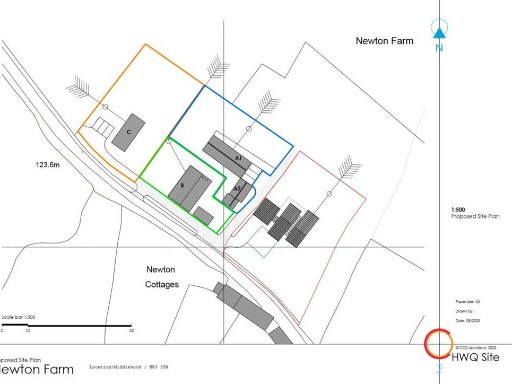 Land for sale in Middlewood, Dorstone, Hereford, HR3 — £100,000 • 1 bed • 1 bath
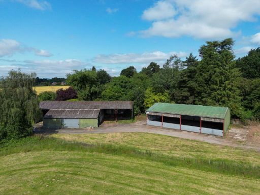 Land for sale in Hereford, Herefordshire, County, HR3 — £470,000 • 1 bed • 1 bath • 6835 ft²
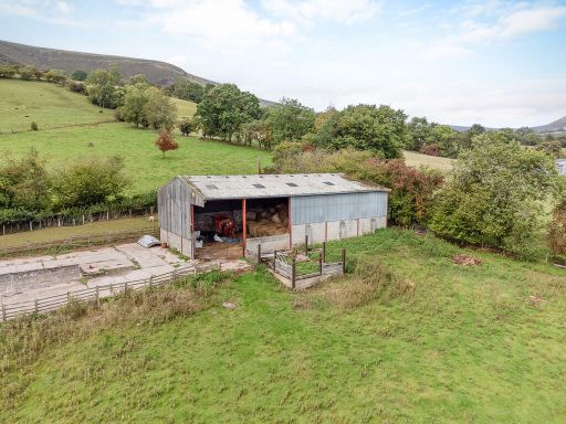 Barn for sale in Olchon House Farm, Longtown, HR2 — £425,000 • 8 bed • 4 bath
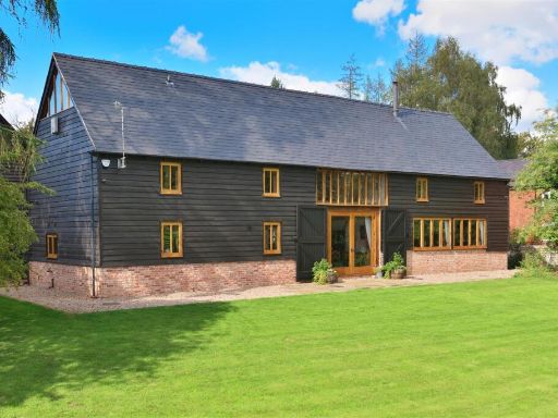 4 bedroom barn conversion for sale in Brobury, Hereford tucked away but not isolated, HR3 — £825,000 • 4 bed • 3 bath • 2622 ft²
Meta
- {
"@context": "https://schema.org",
"@type": "Residence",
"name": "Land for sale in Middlewood, Dorstone, Hereford, HR3",
"description": "",
"url": "https://propertypiper.co.uk/property/7c56b1ae-453a-4ceb-a878-217ce4216f39",
"image": "https://image-a.propertypiper.co.uk/ac69ce81-97ef-4ecc-96ef-8dbfe01dc02c-1024.jpeg",
"address": {
"@type": "PostalAddress",
"streetAddress": "Hay Wired Home Hay Wired Home Hay Wired Home Hay Wired Home Middlewood, Clifford, Hereford",
"postalCode": "HR3 5SX",
"addressLocality": "Herefordshire, County of",
"addressRegion": "Hereford and South Herefordshire",
"addressCountry": "England"
},
"geo": {
"@type": "GeoCoordinates",
"latitude": 52.089806685084596,
"longitude": -3.036017052340024
},
"numberOfRooms": 1,
"numberOfBathroomsTotal": 1,
"offers": {
"@type": "Offer",
"price": 300000,
"priceCurrency": "GBP",
"availability": "https://schema.org/InStock"
},
"additionalProperty": [
{
"@type": "PropertyValue",
"name": "Feature",
"value": "farm"
},
{
"@type": "PropertyValue",
"name": "Feature",
"value": "cottages"
},
{
"@type": "PropertyValue",
"name": "Feature",
"value": "Newton Farm"
},
{
"@type": "PropertyValue",
"name": "Feature",
"value": "Newton Cottages"
},
{
"@type": "PropertyValue",
"name": "Feature",
"value": "property map"
},
{
"@type": "PropertyValue",
"name": "Feature",
"value": "rural"
},
{
"@type": "PropertyValue",
"name": "Feature",
"value": "outbuildings"
},
{
"@type": "PropertyValue",
"name": "Feature",
"value": "land plot"
},
{
"@type": "PropertyValue",
"name": "Feature",
"value": "development opportunity"
},
{
"@type": "PropertyValue",
"name": "Feature",
"value": "contemporary"
},
{
"@type": "PropertyValue",
"name": "Feature",
"value": "concrete block walls"
},
{
"@type": "PropertyValue",
"name": "Feature",
"value": "elevations"
},
{
"@type": "PropertyValue",
"name": "Feature",
"value": "layout"
},
{
"@type": "PropertyValue",
"name": "Feature",
"value": "modern design"
},
{
"@type": "PropertyValue",
"name": "Feature",
"value": "roof"
},
{
"@type": "PropertyValue",
"name": "Feature",
"value": "small size"
},
{
"@type": "PropertyValue",
"name": "Feature",
"value": "52 square meters"
}
]
}