BB8 8FP - Light industrial facility for sale in Unit 89 Spring Garden…
View on Property Piper
Light industrial facility for sale in Unit 8-9 Spring Gardens Mill Business Park, Spring Gardens Road, Colne, BB8 8FP, BB8
Property Details
- Price: £1
- Bedrooms: 1
- Bathrooms: 1
- Property Type: undefined
- Property SubType: undefined
Brochure Descriptions
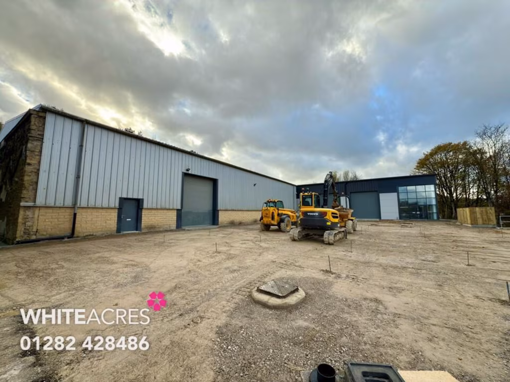
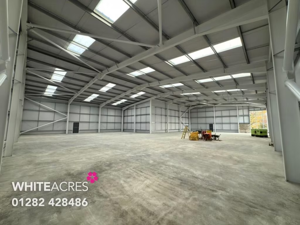
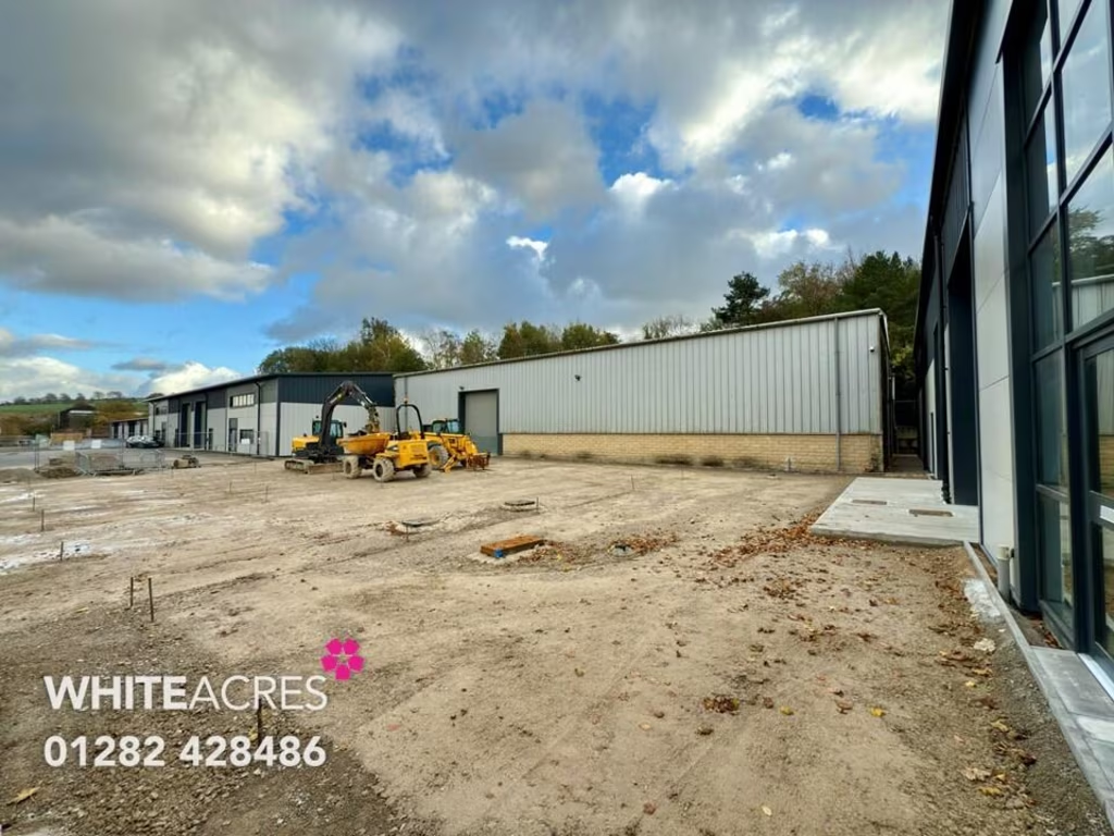
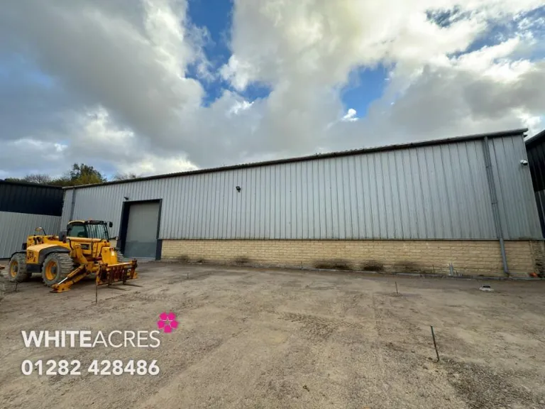
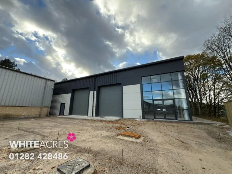
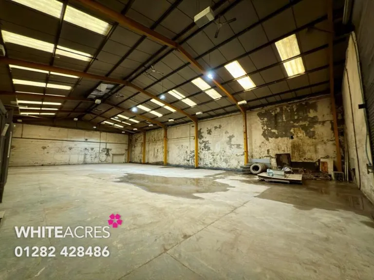
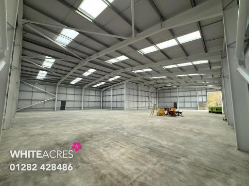
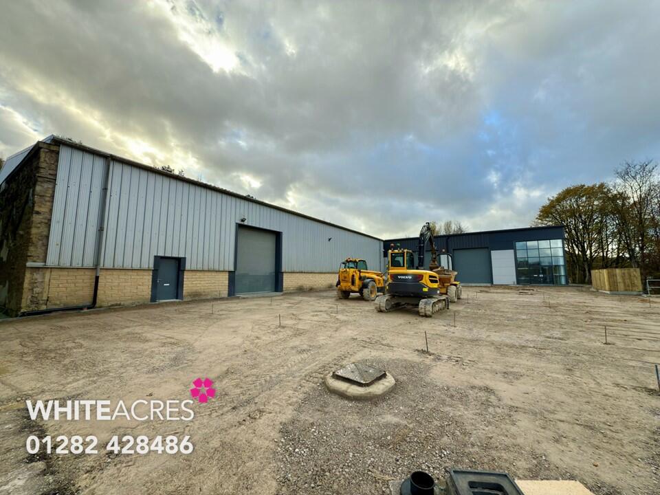
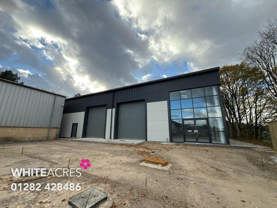
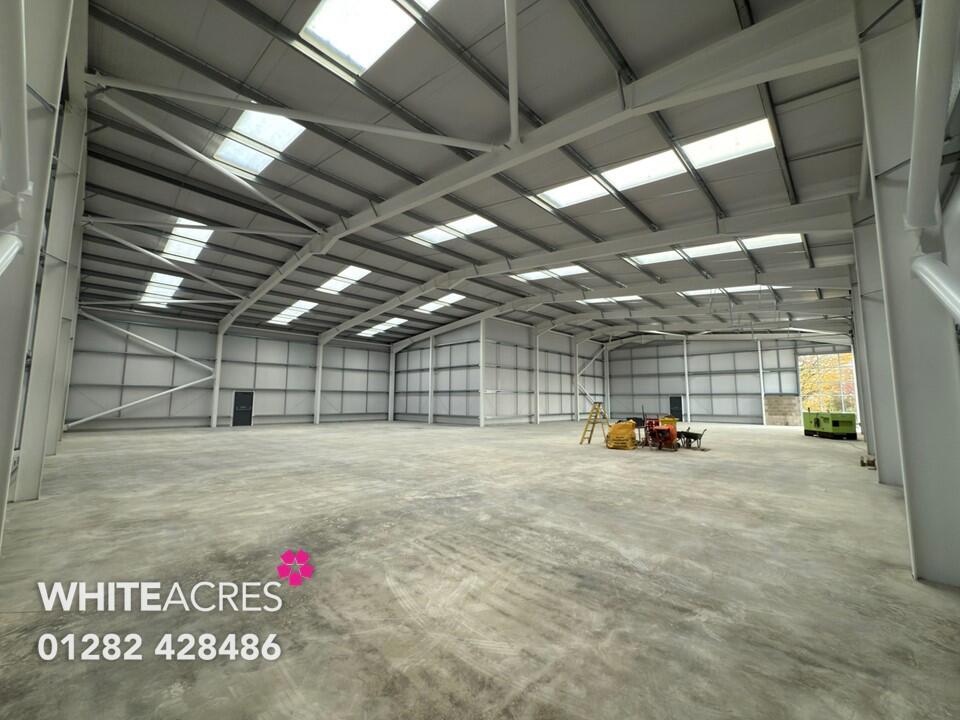
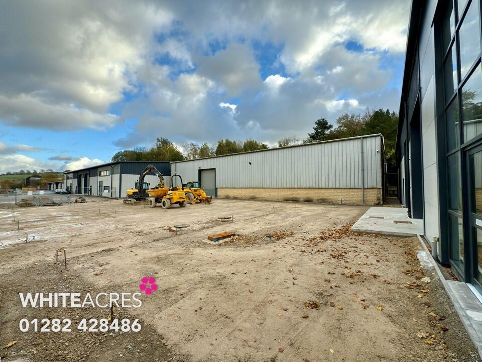
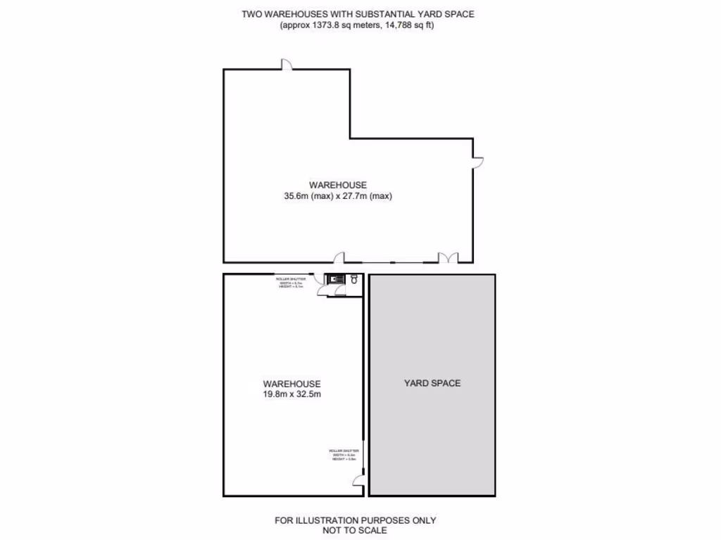
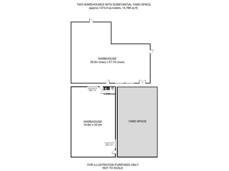
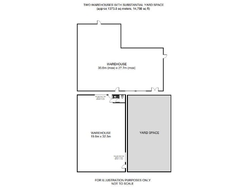
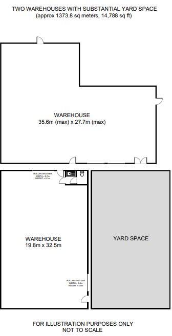
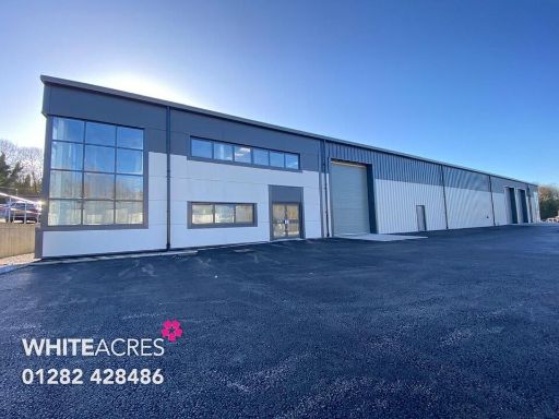
- Two detached industrial warehouse units on Spring Gardens Mill Business Park. The buildings are open-plan warehouse units with good natural light (large glazing to the front), three-phase electricity and electrically operated loading doors. The site includes a substantial yard/forecourt area suitable for loading and vehicle manoeuvring. The units are freehold, positioned on the edge of Colne with industrial neighbours and some mature trees visible to one side. Unit sizes are significant (one circa 6,000 sq ft and the other circa 8,788 sq ft) and there is clear potential to combine both into a single 14,788 sq ft industrial/warehouse premises. Overall the property is large for industrial use, suited to storage, distribution or light industrial occupation with good road links to the M65.
Image Descriptions
- commercial warehouse modern industrial
- industrial building modern industrial
Floorplan Description
- Two warehouses with substantial yard space.
Textual Property Features
Detected Visual Features
- commercial property
- industrial warehouse
- high ceilings
- construction site
- large space
- industrial
- modern
- warehouse
- commercial
- high ceiling
Nearby Schools
- Nelson St Paul's Church of England Primary School
- Nelson St Philip's Church of England Primary School
- Bradley Primary School
- Trawden Forest Primary School
- Ss John Fisher and Thomas More Roman Catholic High School
- Colne Primet Primary School
- Barrowford School
- Colne Park High School
- Edenfield Girls' High School
- Castercliff Primary School
- Holy Saviour Roman Catholic Primary School, Nelson
- Colne Primet Academy
- Laneshaw Bridge Primary
- Foulridge Saint Michael and All Angels CofE Voluntary Aided Primary School
- Kelbrook Primary School
- Walverden Primary School
- West Street Community Primary School
- Colne Lord Street School
- Park Primary School
- Sacred Heart Roman Catholic Primary School, a Voluntary Academy
- Blacko Primary School
- Rosa House School
- Briercliffe Primary School
- Marsden Community Primary School
- Great Marsden St John's Primary School A Church of England Academy
- Pendle Vale College
- Colne Christ Church Church of England Voluntary Aided Primary School
Nearest General Shops
- Id: 3697902729
- Tags:
- Addr:
- City: Colne
- Housename: Live Like The Boy
- Housenumber: 14
- Postcode: BB8 0LG
- Street: Church Street
- Name: Live Like The Boy
- Shop: interior_decoration
- TagsNormalized:
- Lat: 53.8571777
- Lon: -2.1686537
- FullGeoHash: gcw6qskuf9wd
- PartitionGeoHash: gcw6
- Images:
- FoodStandards: null
- Distance: 467.4
,- Id: 1708420871
- Tags:
- Name: Odies Bakers
- Shop: bakery
- TagsNormalized:
- Lat: 53.8570386
- Lon: -2.1682049
- FullGeoHash: gcw6qsm5vptj
- PartitionGeoHash: gcw6
- Images:
- FoodStandards: null
- Distance: 466.3
,- Id: 2329989588
- Tags:
- Name: First Stop Electronic Cigarettes
- Shop: kiosk
- TagsNormalized:
- Lat: 53.856952
- Lon: -2.167984
- FullGeoHash: gcw6qsm76r9b
- PartitionGeoHash: gcw6
- Images:
- FoodStandards: null
- Distance: 464.9
}
Nearest Religious buildings
- Id: 975571052
- Tags:
- Amenity: place_of_worship
- Building: yes
- Religion: christian
- Roof:
- Source: Bing
- TagsNormalized:
- place of worship
- christian
- church
- Lat: 53.8555109
- Lon: -2.1672226
- FullGeoHash: gcw6qsjgh4cs
- PartitionGeoHash: gcw6
- Images:
- FoodStandards: null
- Distance: 372.2
,- Id: 909088234
- Tags:
- Name: Church Clough Brook
- Waterway: stream
- TagsNormalized:
- Lat: 53.8523369
- Lon: -2.1668151
- FullGeoHash: gcw6qew0te1w
- PartitionGeoHash: gcw6
- Images:
- FoodStandards: null
- Distance: 328.7
,- Id: 477546626
- Tags:
- Addr:
- Amenity: place_of_worship
- Building: yes
- Denomination: methodist
- Name: St John's Methodist Church
- Religion: christian
- TagsNormalized:
- place of worship
- methodist
- church
- christian
- Lat: 53.8561708
- Lon: -2.1713934
- FullGeoHash: gcw6qs4yfvgs
- PartitionGeoHash: gcw6
- Images:
- FoodStandards: null
- Distance: 315.7
}
Nearest Medical buildings
- Id: 1014366378
- Tags:
- Amenity: doctors
- Building: yes
- Healthcare: doctor
- Name: Harambee Surgery
- Website: https://www.harambeesurgery.co.uk/home/index.php
- TagsNormalized:
- doctor
- doctors
- health
- healthcare
- surgery
- Lat: 53.8487211
- Lon: -2.137504
- FullGeoHash: gcw6r6ge891m
- PartitionGeoHash: gcw6
- Images:
- FoodStandards: null
- Distance: 2290.2
,- Id: 7497235419
- Tags:
- Amenity: pharmacy
- Brand: Asda
- Brand:wikidata: Q297410
- Brand:wikipedia: en:Asda
- Contact:
- Phone: +44 1282 870156
- Website: https://storelocator.asda.com/north-west/colne/unit-1-swinden-retail-park/pharmacy
- Fixme: Location not accurate
- Operator: Asda Stores Ltd
- TagsNormalized:
- Lat: 53.8492377
- Lon: -2.1973756
- FullGeoHash: gcw6mfzyt3mz
- PartitionGeoHash: gcw6
- Images:
- FoodStandards: null
- Distance: 1755.2
,- Id: 1775530764
- Tags:
- Amenity: hospital
- Name: health center
- TagsNormalized:
- Lat: 53.8573814
- Lon: -2.1676761
- FullGeoHash: gcw6qsmtcrxd
- PartitionGeoHash: gcw6
- Images:
- FoodStandards: null
- Distance: 516.4
,- Id: 1708321909
- Tags:
- Addr:
- Amenity: veterinary
- Name: Stanley House Veterinary Surgery
- TagsNormalized:
- Lat: 53.8564419
- Lon: -2.1720421
- FullGeoHash: gcw6qs62eb2j
- PartitionGeoHash: gcw6
- Images:
- FoodStandards: null
- Distance: 347.3
}
Nearest Leisure Facilities
- Id: 1005556862
- Tags:
- TagsNormalized:
- Lat: 53.8519311
- Lon: -2.1729771
- FullGeoHash: gcw6qe3wjzwc
- PartitionGeoHash: gcw6
- Images:
- FoodStandards: null
- Distance: 182.4
,- Id: 1005556863
- Tags:
- TagsNormalized:
- Lat: 53.8519501
- Lon: -2.1729789
- FullGeoHash: gcw6qe3wmgj7
- PartitionGeoHash: gcw6
- Images:
- FoodStandards: null
- Distance: 180.7
,- Id: 896786041
- Tags:
- TagsNormalized:
- Lat: 53.853471
- Lon: -2.1696291
- FullGeoHash: gcw6qesp5yx7
- PartitionGeoHash: gcw6
- Images:
- FoodStandards: null
- Distance: 125.8
,- Id: 904154292
- Tags:
- Leisure: pitch
- Sport: soccer;basketball
- Surface: asphalt
- TagsNormalized:
- pitch
- leisure
- soccer
- basketball
- sports
- Lat: 53.8537099
- Lon: -2.1705903
- FullGeoHash: gcw6qeg2te4s
- PartitionGeoHash: gcw6
- Images:
- FoodStandards: null
- Distance: 74.7
,- Id: 904154293
- Tags:
- Access: yes
- Leisure: playground
- TagsNormalized:
- Lat: 53.8538564
- Lon: -2.171193
- FullGeoHash: gcw6qefcrw3n
- PartitionGeoHash: gcw6
- Images:
- FoodStandards: null
- Distance: 62.3
}
Nearest Tourist attractions
- Id: 259666186
- Tags:
- Building: yes
- Listed_status: Grade II
- Tourism: museum
- TagsNormalized:
- Lat: 53.853909
- Lon: -2.2106888
- FullGeoHash: gcw6mey1z0qb
- PartitionGeoHash: gcw6
- Images:
- FoodStandards: null
- Distance: 2569
,- Id: 972946099
- Tags:
- Museum: history
- Tourism: museum
- TagsNormalized:
- Lat: 53.8462895
- Lon: -2.1354048
- FullGeoHash: gcw6r6mj37yu
- PartitionGeoHash: gcw6
- Images:
- FoodStandards: null
- Distance: 2495.9
,- Id: 1730727200
- Tags:
- Addr:
- City: Nelson
- Housename: Hendon Mill
- Postcode: BB9 8AD
- Street: Hallam Road
- Name: British in India
- Opening_hours: Mo-Fr 09:00-16:00
- Tourism: museum
- Website: https://www.visitpendle.com/things-to-do/british-in-india-museum-p7152
- Wikidata: Q113280064
- TagsNormalized:
- Lat: 53.8394735
- Lon: -2.2011897
- FullGeoHash: gcw6mcjjst3c
- PartitionGeoHash: gcw6
- Images:
- FoodStandards: null
- Distance: 2481.9
}
Nearest Bus stations and stops
- Id: 5001916871
- Tags:
- Bus: yes
- Highway: bus_stop
- Name: Atkinson Street
- Public_transport: platform
- TagsNormalized:
- Lat: 53.8514726
- Lon: -2.1773319
- FullGeoHash: gcw6q7qe86pd
- PartitionGeoHash: gcw6
- Images:
- FoodStandards: null
- Distance: 433
,- Id: 7734905260
- Tags:
- Bench: no
- Bus: yes
- Highway: bus_stop
- Name: Walton Street
- Public_transport: platform
- Shelter: no
- Tactile_paving: no
- TagsNormalized:
- Lat: 53.8566843
- Lon: -2.1697366
- FullGeoHash: gcw6qsk1cmx5
- PartitionGeoHash: gcw6
- Images:
- FoodStandards: null
- Distance: 390.8
,- Id: 4944678404
- Tags:
- Bench: no
- Bus: yes
- Highway: bus_stop
- Name: Muncipal Hall
- Public_transport: platform
- Shelter: yes
- Tactile_paving: no
- TagsNormalized:
- Lat: 53.8558362
- Lon: -2.1754212
- FullGeoHash: gcw6qkpuvp82
- PartitionGeoHash: gcw6
- Images:
- FoodStandards: null
- Distance: 377.5
,- Id: 4944678405
- Tags:
- Bench: yes
- Bus: yes
- Highway: bus_stop
- Name: Muncipal Hall
- Public_transport: platform
- Shelter: yes
- Tactile_paving: no
- TagsNormalized:
- Lat: 53.8556824
- Lon: -2.1755538
- FullGeoHash: gcw6qkpu1fve
- PartitionGeoHash: gcw6
- Images:
- FoodStandards: null
- Distance: 371.2
,- Id: 4944678406
- Tags:
- Bench: no
- Bus: yes
- Highway: bus_stop
- Name: St Johns Church
- Public_transport: platform
- Shelter: yes
- Tactile_paving: no
- TagsNormalized:
- Lat: 53.8564128
- Lon: -2.1714112
- FullGeoHash: gcw6qs6b67n2
- PartitionGeoHash: gcw6
- Images:
- FoodStandards: null
- Distance: 342.6
}
Nearest Hotels
- Id: 477551743
- Tags:
- Addr:
- City: Barnoldswick
- County: Lancashire
- Housenumber: 400
- Postcode: BB18 6TF
- Street: Colne Road
- Village: Kelbrook
- Building: yes
- Fhrs:
- Name: The Craven Heifer Inn
- Tourism: hotel
- Website: thecravenheiferinn.co.uk
- TagsNormalized:
- Lat: 53.8987903
- Lon: -2.1511487
- FullGeoHash: gcw6x5cx4wer
- PartitionGeoHash: gcw6
- Images:
- FoodStandards: null
- Distance: 5228.3
,- Id: 477546646
- Tags:
- Addr:
- City: Barnoldswick
- Postcode: BB18 6XY
- Street: Colne Road
- Building: yes
- Name: Old Stone Trough Hotel
- Tourism: hotel
- TagsNormalized:
- Lat: 53.8930095
- Lon: -2.1567123
- FullGeoHash: gcw6wfvt8cnu
- PartitionGeoHash: gcw6
- Images:
- FoodStandards: null
- Distance: 4517.5
,- Id: 1708313834
- Tags:
- Addr:
- Housenumber: 94
- Postcode: BB8 0QD
- Street: Albert Road
- Amenity: pub
- Fhrs:
- Name: Crown Hotel
- Source:
- TagsNormalized:
- Lat: 53.8550389
- Lon: -2.1801273
- FullGeoHash: gcw6qkh2r6gk
- PartitionGeoHash: gcw6
- Images:
- FoodStandards: null
- Distance: 594.7
}
Tags
- commercial property
- industrial warehouse
- high ceilings
- construction site
- large space
- industrial
- modern
- industrial
- warehouse
- modern
- commercial
- large space
- high ceiling
Local Market Stats
- Average Price/sqft: £156
- Avg Income: £37500
- Rental Yield: 4.1%
- Social Housing: 5%
- Planning Success Rate: 82%
Similar Properties
 Light industrial facility for sale in Unit 2 Spring Gardens Mill Business Park , Spring Gardens Road , Colne, BB8 8FP, BB8 — £1,310,660 • 1 bed • 1 bath • 10082 ft²
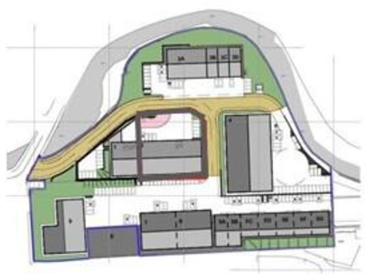 Light industrial facility for sale in 5A Spring Gardens Mill Business Park, Spring Gardens Road, Colne, BB8 8FP, BB8 — £269,920 • 1 bed • 1 bath • 1687 ft²
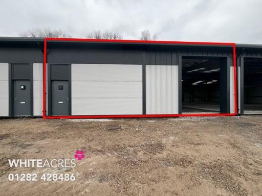 Light industrial facility for sale in 5D Spring Gardens Mill Business Park, Spring Gardens Road, Colne BB8 8FP, BB8 — £259,680 • 1 bed • 1 bath • 1632 ft²
 Light industrial facility for sale in 5c Spring Garden Business Park, Spring Garden Road, Colne, BB8 8FP, BB8 — £259,680 • 1 bed • 1 bath • 1623 ft²
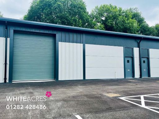 Light industrial facility for sale in 5B Spring Garden Business Park, Spring Garden Road, Colne, BB8 8AL, BB8 — £259,680 • 1 bed • 1 bath • 1623 ft²
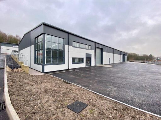 Industrial park for sale in Unit One Spring Gardens Business Park, Spring Gardens Road, Colne, BB8 8AL, BB8 — £1,310,660 • 1 bed • 1 bath • 10000 ft²
Meta
- {
"@context": "https://schema.org",
"@type": "Residence",
"name": "Light industrial facility for sale in Unit 89 Spring Garden…",
"description": "",
"url": "https://propertypiper.co.uk/property/6f6633c7-3094-49cc-a38f-220e4c6f25f5",
"image": "https://image-a.propertypiper.co.uk/d28caf55-bcda-4abe-a69c-437d87a7b8a7-1024.jpeg",
"address": {
"@type": "PostalAddress",
"streetAddress": "Unit 8-9 Spring Gardens Mill Business Park, Spring Gardens Road, Colne, BB8 8FP",
"postalCode": "BB8 8FP",
"addressLocality": "Pendle",
"addressRegion": "Pendle",
"addressCountry": "England"
},
"geo": {
"@type": "GeoCoordinates",
"latitude": 53.853333,
"longitude": -2.171533
},
"numberOfRooms": 1,
"numberOfBathroomsTotal": 1,
"floorSize": {
"@type": "QuantitativeValue",
"value": 8788,
"unitCode": "FTK"
},
"offers": {
"@type": "Offer",
"price": 1,
"priceCurrency": "GBP",
"availability": "https://schema.org/InStock"
},
"additionalProperty": [
{
"@type": "PropertyValue",
"name": "Feature",
"value": "commercial property"
},
{
"@type": "PropertyValue",
"name": "Feature",
"value": "industrial warehouse"
},
{
"@type": "PropertyValue",
"name": "Feature",
"value": "high ceilings"
},
{
"@type": "PropertyValue",
"name": "Feature",
"value": "construction site"
},
{
"@type": "PropertyValue",
"name": "Feature",
"value": "large space"
},
{
"@type": "PropertyValue",
"name": "Feature",
"value": "industrial"
},
{
"@type": "PropertyValue",
"name": "Feature",
"value": "modern"
},
{
"@type": "PropertyValue",
"name": "Feature",
"value": "industrial"
},
{
"@type": "PropertyValue",
"name": "Feature",
"value": "warehouse"
},
{
"@type": "PropertyValue",
"name": "Feature",
"value": "modern"
},
{
"@type": "PropertyValue",
"name": "Feature",
"value": "commercial"
},
{
"@type": "PropertyValue",
"name": "Feature",
"value": "large space"
},
{
"@type": "PropertyValue",
"name": "Feature",
"value": "high ceiling"
}
]
}
High Res Floorplan Images
Compatible Floorplan Images
FloorplanImages Thumbnail