HU17 0XG - 4 bedroom detached house for sale in Beverley, East Yorkshi…
View on Property Piper
4 bedroom detached house for sale in Beverley,
East Yorkshire,
HU17 ONJ, HU17
Property Details
- Price: £464995
- Bedrooms: 4
- Bathrooms: 1
- Property Type: undefined
- Property SubType: undefined
Brochure Descriptions
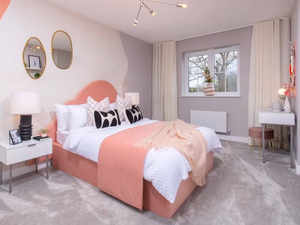
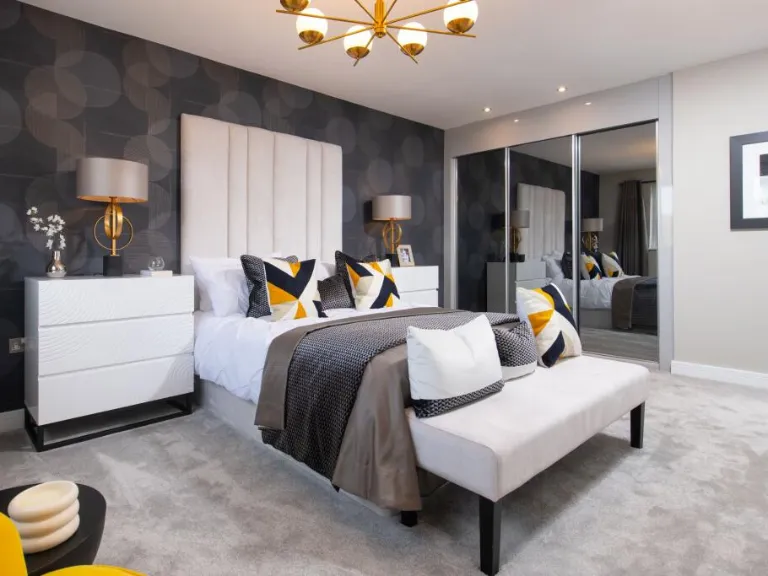
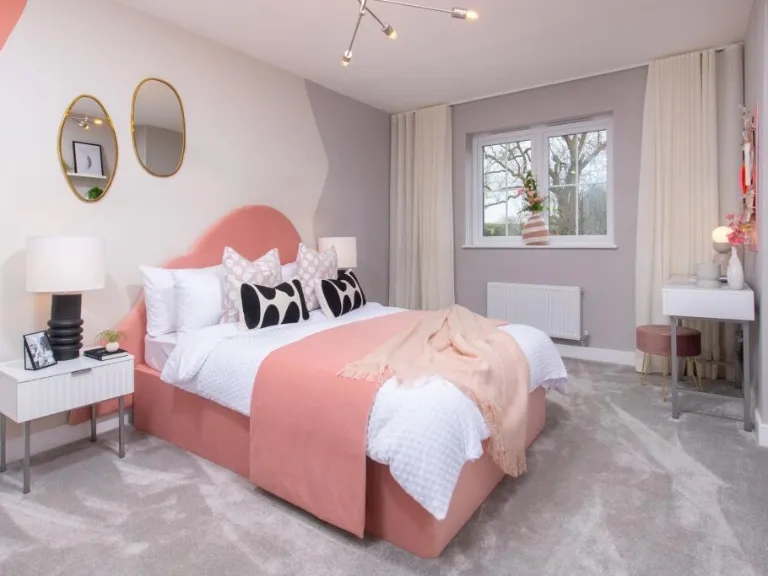
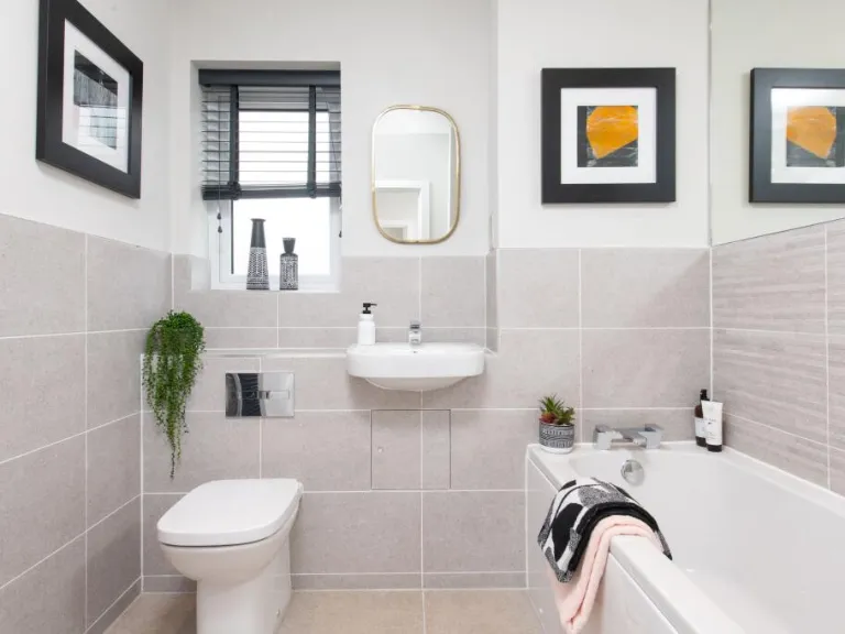
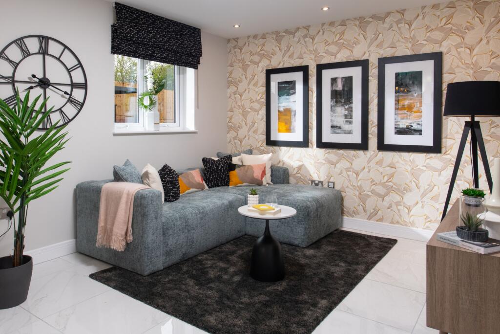
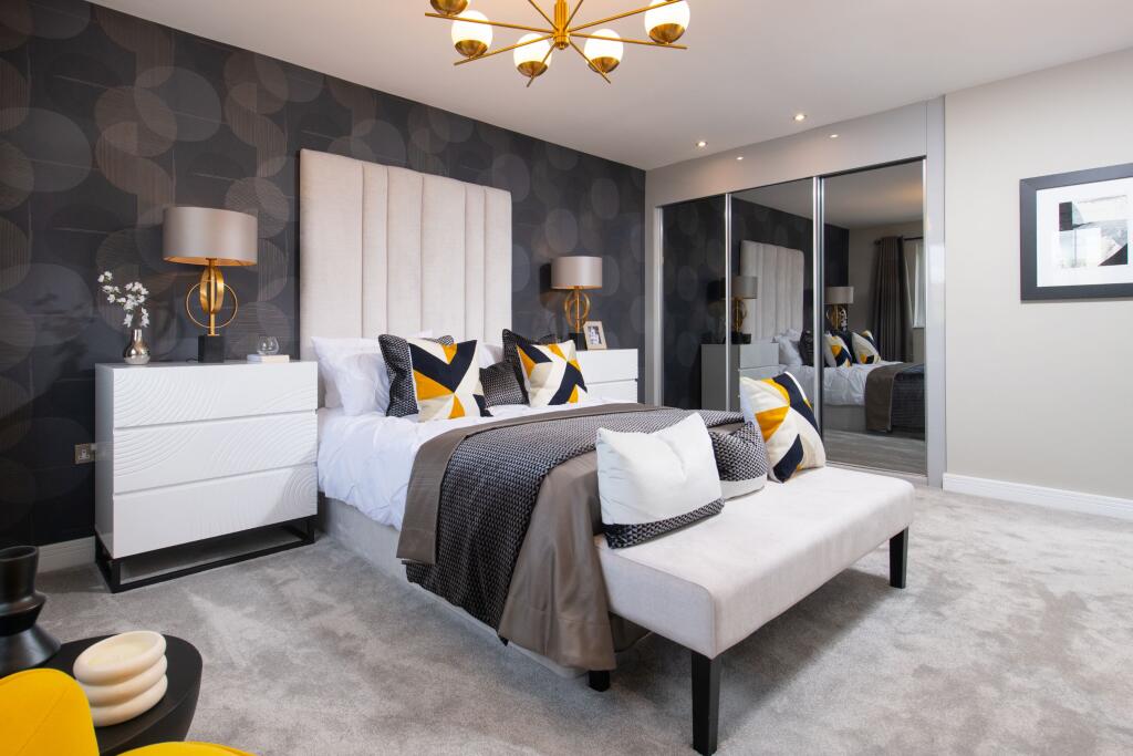
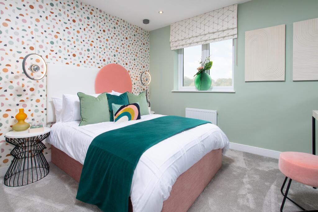
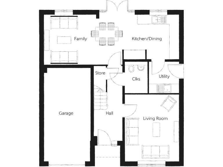
- A substantial modern detached residential property named The Millium. The house is two stories with a contemporary exterior design, featuring a combination of brick and cladding. There is an integral garage. The downstairs consists of a separate kitchen/breakfast room, a utility area, living room, dining room, study, porch, cloakroom, and WC. The garden appears to be average size for a detached property. Upstairs, there are 5 bedrooms, including a master bedroom with an en-suite and a walk-in wardrobe. The overall property size is large, supporting a family and offering generous bedroom sizes. The home is suitable for modern family living, benefiting from a garage and ample parking. No exceptional view is described or depicted in the image.
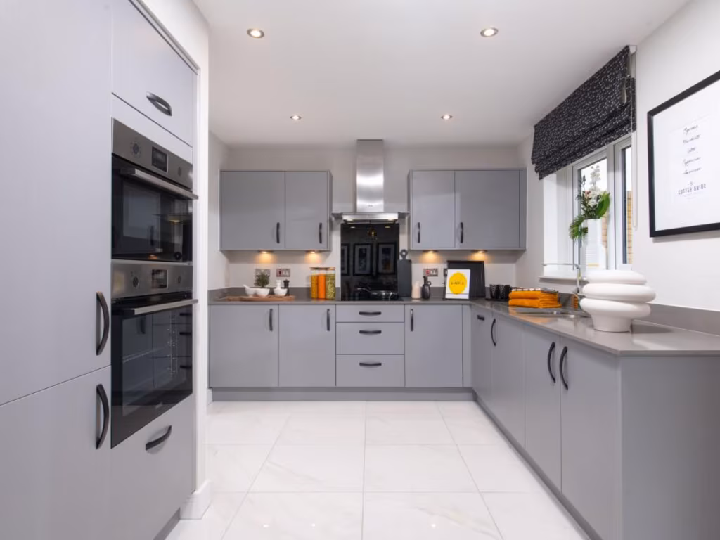
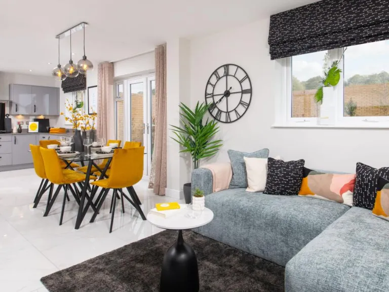
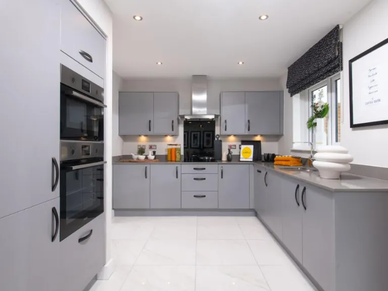
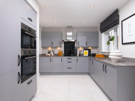
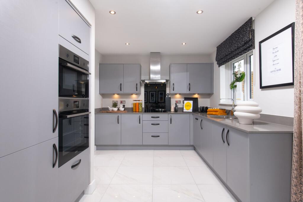
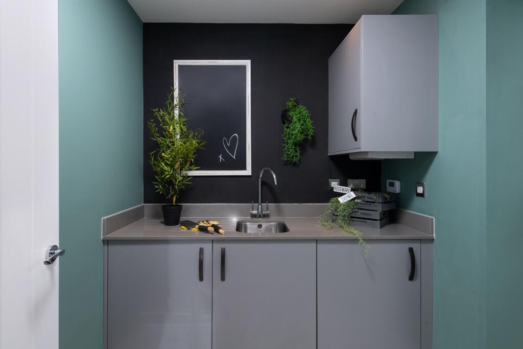
- The property for sale appears to be a new home located in a modern residential development at Pilgrims' Way. Based on the image, the kitchen is modern with high-spec fixtures, including sleek cabinetry and built-in appliances. The room has a large window providing ample natural light. The overall presentation suggests a family-oriented property, likely with an average or larger kitchen and potentially spacious communal areas. The flooring appears high quality, and the finish throughout the visible space is to a high standard. No specific views or outdoor areas are visible in the image provided.
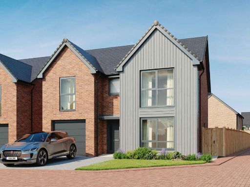
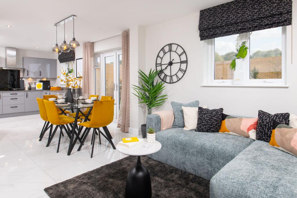
- Pilgrims Way is a modern residential development featuring a variety of detached and semi-detached family homes, each with its own private garden. The properties have 3-5 bedrooms and are presented in contemporary architectural styles with brick facades and integrated garages or parking spaces. The layout offers generous green spaces and pedestrian pathways throughout. Most properties have medium to large gardens, and the streets are well-spaced, likely providing a sense of openness. The area appears to be a new or ongoing development, with future expansions planned.
- Based on the image, the property appears to be a newly built family home with a modern kitchen. The kitchen is of average size with contemporary cabinetry and ample light from a large window, suggesting good natural illumination. The finish is of high standard, and the flooring appears new. The room size is average, suitable for a family. There is no visible garden or view included in the current image, so further details are not available. Overall, the property gives the impression of a modern, comfortable family home with good quality fixtures and fittings.
- The image provides a development site plan called Elgin's Way beyond, showing a neighborhood layout with a mixture of detached and semi-detached houses. The featured house types include 2, 3, and 4 bedroom homes, with a variety of exterior styles demonstrated in the images. Most properties appear to have private driveways or garages, and small to average sized gardens. The streets are fully laid out, promising a well-organized residential area. No exceptional views are indicated, suggesting a suburban setting. Property sizes vary, with some large detached homes and some smaller properties.
- The property appears to be a newly built home with a contemporary design, focusing on modern finishes and quality construction. The kitchen, visible in the image, is modern with sleek cabinetry, integrated appliances, and laminate or hardwood flooring. The room size shown (kitchen) is average, providing sufficient space for family activities. The overall property likely features practical and well-designed living spaces ideal for families, in a development emphasizing quality and comfort. There are no views visible in the image, so aspect or scenery cannot be commented upon.
- The development consists of newly built detached and semi-detached houses with modern brick exteriors and pitched roofs, shown across a planned estate layout named 'Pilgrims Way'. The images depict homes with multiple bedrooms (3, 4, and 5-bedroom options). The properties appear to have off-road parking, some with garages, and small to medium private gardens at the rear. The overall estate is surrounded by green landscaping and open spaces, indicative of a suburban location. Most homes are two stories, some with attic rooms. Several house designs are available, each prominently displaying a contemporary yet traditional style.
Image Descriptions
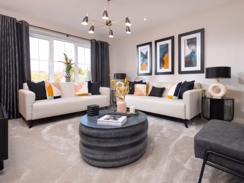
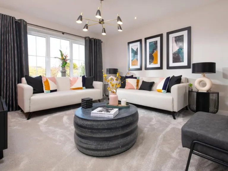
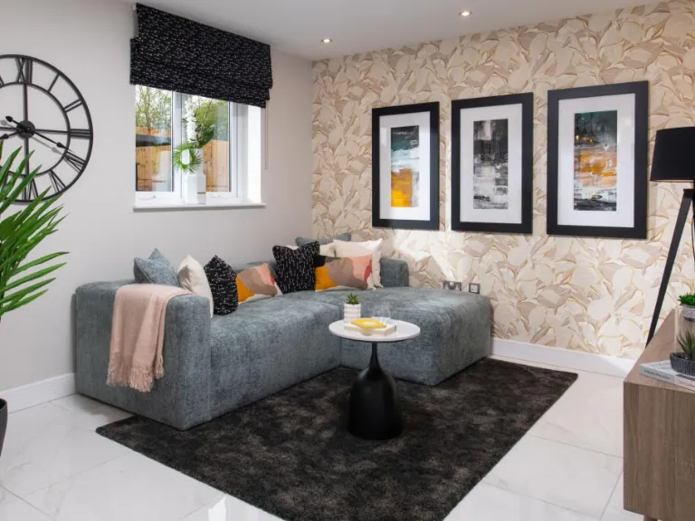
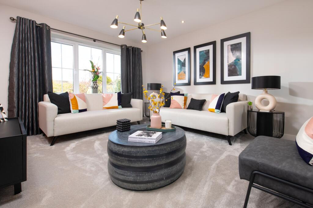
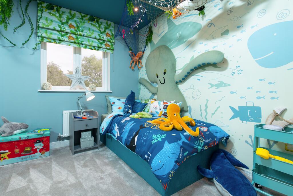
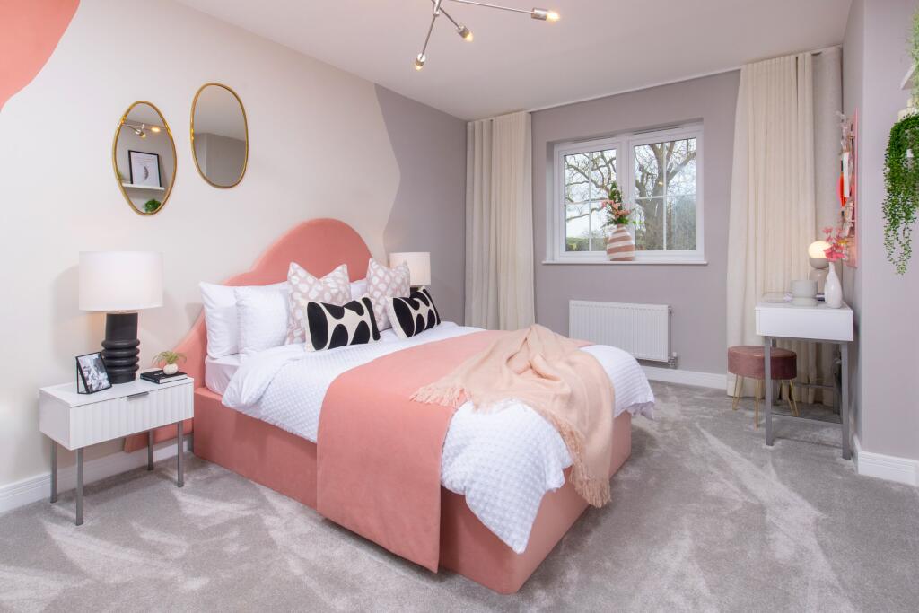
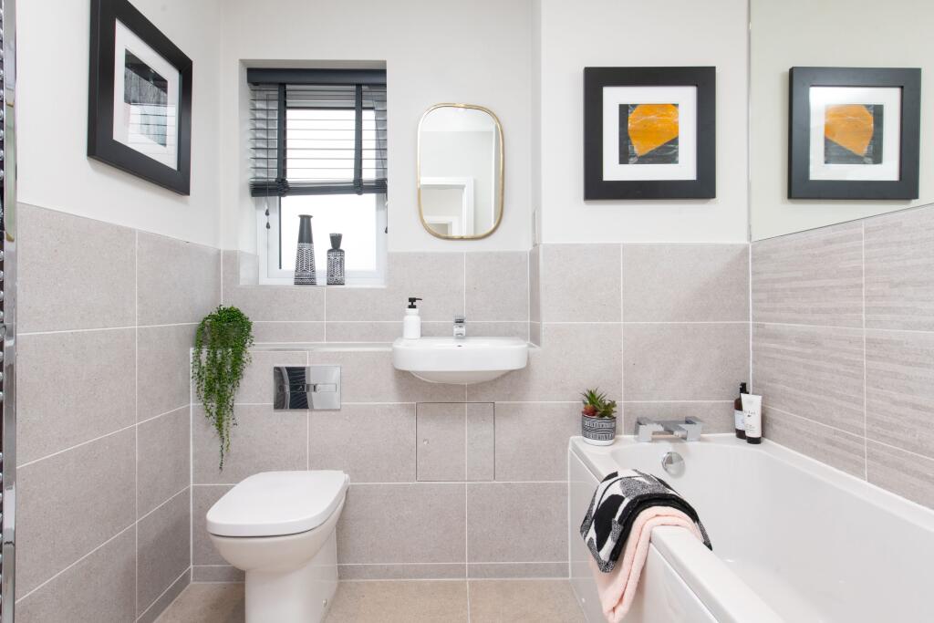
- living room modern
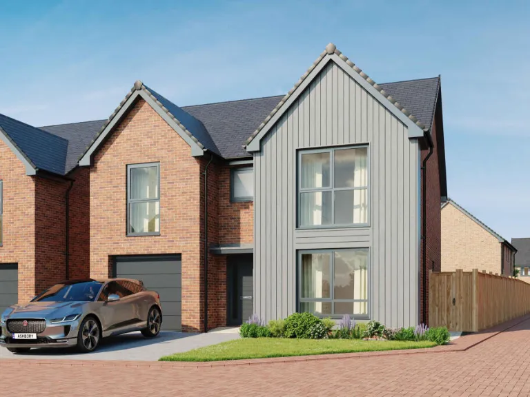
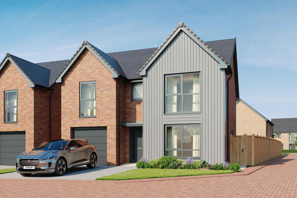
- modern detached house contemporary
Floorplan Description
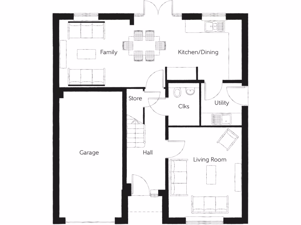
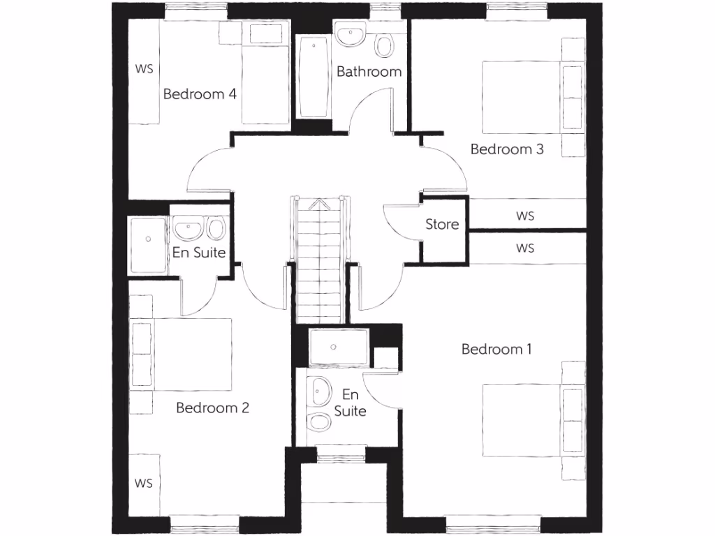
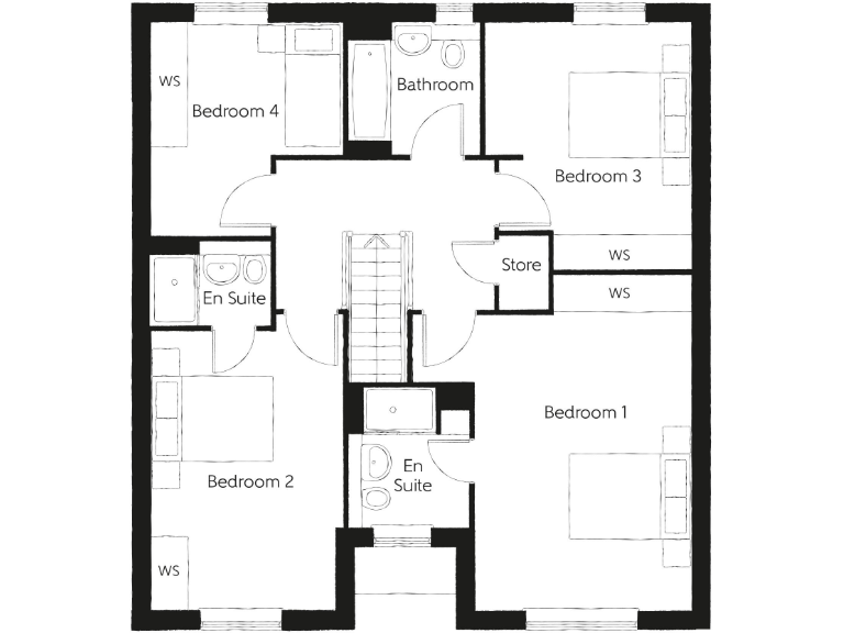
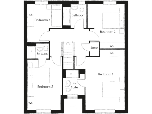
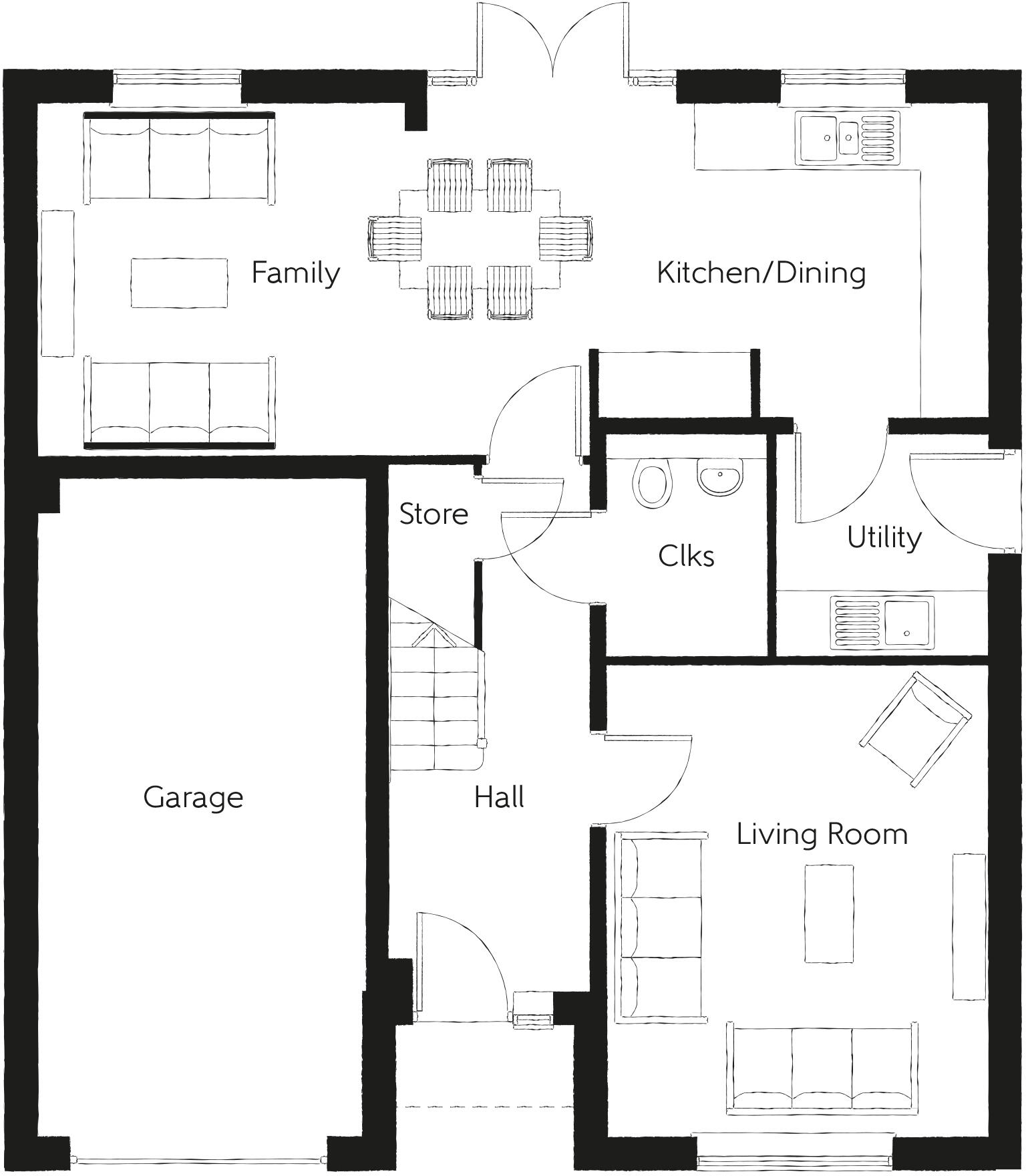
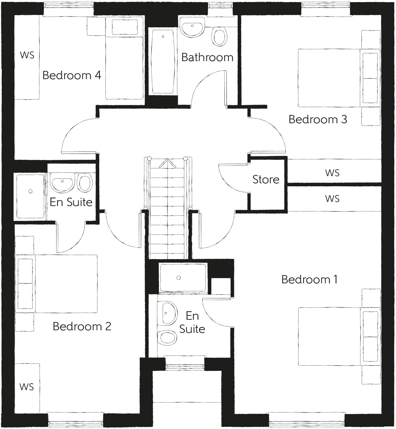
- A floor plan with four bedrooms, two en suites, a bathroom, and a store.
Rooms
- Family:
- Kitchen/Dining:
- Living Room:
- Utility:
- Store:
- Clks:
- Bedroom 1:
- Bedroom 2:
- Bedroom 3:
- Bedroom 4:
- Bathroom:
- En Suite:
- En Suite:
- Store:
Textual Property Features
- Is New Build
- Has Garden
- Chain Free
- Success
Detected Visual Features
- modern
- living room
- large windows
- natural light
- neutral colors
- decorative lighting
- detached
- contemporary
- two-story
- new-build
- brick exterior
- lawn
- garage
Nearby Schools
- Wold Academy
- Westfield Primary School
- St Anthony's Voluntary Catholic Academy
- Cottingham High School and Sixth Form College
- Walkington Primary School
- Keldmarsh Primary School
- Beverley St Nicholas Primary School
- St John of Beverley Catholic Primary School - a Catholic voluntary academy
- Swinemoor Primary School
- Molescroft Primary School
- Croxby Primary School
- Bacon Garth Primary School
- Skidby Church of England Voluntary Controlled Primary School
- Woodmansey Church of England Voluntary Controlled Primary School
- Beverley Grammar School
- Beverley High School
- Tickton Church of England Voluntary Controlled Primary School
- Wolfreton School and Sixth Form College
- Thorpepark Academy
- Leconfield Primary School
- Hall Road Academy
- Hallgate Primary School Cottingham
- The Parks Primary Academy
- Dunswell Primary School
- St Mary's Church of England Voluntary Controlled Primary School, Beverley
- Longcroft School and Sixth Form College
Nearest Bars And Restaurants
- Id: 895055560
- Tags:
- Amenity: pub
- Building: yes
- Name: The Tiger Inn
- Wikidata: Q26629900
- TagsNormalized:
- Lat: 53.8385068
- Lon: -0.4303457
- FullGeoHash: gcxdq1n8h1nf
- PartitionGeoHash: gcxd
- Images:
- FoodStandards: null
- Distance: 753.7
,- Id: 8296817186
- Tags:
- Addr:
- City: Beverley
- Housenumber: Unit 4
- Postcode: HU17 8RH
- Street: Lincoln Way
- Amenity: fast_food
- Cuisine: pizza;burger;kebab
- Drive_through: no
- Name: Olive Tree
- Phone: +441482887777
- Website: https://olivetree-online.com/
- TagsNormalized:
- fast food
- food
- pizza
- burgers
- kebab
- Lat: 53.8296921
- Lon: -0.4345981
- FullGeoHash: gcxdnp7s9juj
- PartitionGeoHash: gcxd
- Images:
- FoodStandards: null
- Distance: 619
,- Id: 8296817187
- Tags:
- Addr:
- City: Beverley
- Housenumber: Unit 2
- Postcode: HU17 8RH
- Street: Lincoln Way
- Amenity: pub
- Name: LJs
- TagsNormalized:
- Lat: 53.8297869
- Lon: -0.4346645
- FullGeoHash: gcxdnp7mpxdd
- PartitionGeoHash: gcxd
- Images:
- FoodStandards: null
- Distance: 618.3
,- Id: 621919648
- Tags:
- Addr:
- City: Beverley
- Housenumber: Unit 5
- Postcode: HU17 8RH
- Street: Lincoln Way
- Amenity: fast_food
- Cuisine: fish_and_chips
- Drive_through: no
- Name: Stuarts of Driffield
- Phone: +441482861757
- Website: https://stuartsofdriffield.co.uk
- TagsNormalized:
- Lat: 53.8296746
- Lon: -0.4345463
- FullGeoHash: gcxdnp7sd6du
- PartitionGeoHash: gcxd
- Images:
- FoodStandards: null
- Distance: 616.9
,- Id: 621919651
- Tags:
- Addr:
- City: Beverley
- Housenumber: Unit 1
- Postcode: HU17 8RH
- Street: Lincoln Way
- Amenity: fast_food
- Cuisine: chinese
- Name: Wong's Kitchen
- TagsNormalized:
- fast food
- food
- chinese
- kitchen
- Lat: 53.8298287
- Lon: -0.4346239
- FullGeoHash: gcxdnp7t2x2g
- PartitionGeoHash: gcxd
- Images:
- FoodStandards: null
- Distance: 613.9
}
Nearest General Shops
- Id: 4077870362
- Tags:
- Name: Minster Cake Shop
- Shop: bakery
- TagsNormalized:
- Lat: 53.839946
- Lon: -0.4258283
- FullGeoHash: gcxdq33bmmr7
- PartitionGeoHash: gcxd
- Images:
- FoodStandards: null
- Distance: 862.5
,- Id: 1105022429
- Tags:
- Brand: Jewson
- Brand:wikidata: Q6190226
- Building: yes
- Name: Jewson
- Shop: trade
- Trade: building_supplies
- TagsNormalized:
- Lat: 53.8385731
- Lon: -0.4204977
- FullGeoHash: gcxdq3jb3tqn
- PartitionGeoHash: gcxd
- Images:
- FoodStandards: null
- Distance: 801.2
,- Id: 9533059492
- Tags:
- Addr:
- City: Beverley
- Street: Lincoln Way
- Name: Lewis Norton Funeral Directors
- Shop: funeral_directors
- TagsNormalized:
- funeral
- funeral directors
- shop
- Lat: 53.8297164
- Lon: -0.434661
- FullGeoHash: gcxdnp7kzdmm
- PartitionGeoHash: gcxd
- Images:
- FoodStandards: null
- Distance: 621.5
}
Nearest Grocery shops
- Id: 6651790419
- Tags:
- Amenity: fast_food
- Brand: Greggs
- Brand:wikidata: Q3403981
- Brand:wikipedia: en:Greggs
- Contact:
- Website: https://www.greggs.co.uk/shop-finder?shop-code=3618
- Cuisine: sandwich;bakery
- Name: Greggs
- Shop: bakery
- Takeaway: yes
- TagsNormalized:
- fast food
- food
- greggs
- sandwich
- bakery
- shop
- takeaway
- Lat: 53.8399374
- Lon: -0.4207205
- FullGeoHash: gcxdq3m8keb0
- PartitionGeoHash: gcxd
- Images:
- FoodStandards: null
- Distance: 932.5
,- Id: 9705789952
- Tags:
- Brand: One Stop
- Brand:wikidata: Q65954217
- Name: One Stop
- Shop: convenience
- TagsNormalized:
- Lat: 53.839241
- Lon: -0.4197494
- FullGeoHash: gcxdq3nk71un
- PartitionGeoHash: gcxd
- Images:
- FoodStandards: null
- Distance: 889.8
,- Id: 156811267
- Tags:
- Addr:
- City: Beverley
- Postcode: HU17 8RH
- Street: Lincoln Way
- Brand: Co-op Food
- Brand:wikidata: Q3277439
- Brand:wikipedia: en:Co-op Food
- Building: retail
- Name: Co-op Food
- Opening_hours: Mo-Su,PH 07:00-23:00
- Opening_hours:covid19: Mo-Su,PH 07:00-22:00
- Operator: The Co-operative Group
- Operator:wikidata: Q117202
- Phone: +441482888339
- Shop: convenience
- Website: https://www.coop.co.uk/store-finder/HU17-8RH/lincoln-way
- TagsNormalized:
- co-op
- co-op food
- food
- retail
- convenience
- shop
- Lat: 53.8295133
- Lon: -0.4346296
- FullGeoHash: gcxdnp7e8ksd
- PartitionGeoHash: gcxd
- Images:
- FoodStandards: null
- Distance: 630
}
Nearest Supermarkets
- Id: 204966616
- Tags:
- Addr:
- City: Beverley
- Country: GB
- Housenumber: 18-20
- Postcode: HU17 9EY
- Street: Norwood
- Brand: Asda
- Brand:wikidata: Q297410
- Brand:wikipedia: en:Asda
- Building: retail
- Contact:
- Website: https://storelocator.asda.com/yorkshire-&-humber/beverley/20-norwood
- Designation: Beverley Supermarket
- Fhrs:
- Name: Asda
- Opening_hours: Mo-Sa 07:00-22:00; Su 10:00-16:00
- Shop: supermarket
- TagsNormalized:
- asda
- retail
- supermarket
- shop
- Lat: 53.8452586
- Lon: -0.430194
- FullGeoHash: gcxdq4nxrg8n
- PartitionGeoHash: gcxd
- Images:
- FoodStandards:
- Id: 491384
- FHRSID: 491384
- LocalAuthorityBusinessID: 39770
- BusinessName: Asda Stores Ltd.
- BusinessType: Retailers - supermarkets/hypermarkets
- BusinessTypeID: 7840
- AddressLine1: 18-20 Norwood
- AddressLine2: Beverley
- AddressLine3: East Riding Of Yorkshire
- AddressLine4: null
- PostCode: HU17 9EW
- RatingValue: 5
- RatingKey: fhrs_5_en-GB
- RatingDate: 2022-06-30
- LocalAuthorityCode: 863
- LocalAuthorityName: East Riding of Yorkshire
- LocalAuthorityWebSite: http://www.eastriding.gov.uk
- LocalAuthorityEmailAddress: food.services@eastriding.gov.uk
- Scores:
- Hygiene: 0
- Structural: 0
- ConfidenceInManagement: 0
- NewRatingPending: false
- Geocode:
- Longitude: null
- Latitude: null
- Distance: 1476.7
,- Id: 204966617
- Tags:
- Addr:
- Postcode: HU17 9DB
- Street: Morton Lane
- Brand: Tesco
- Brand:wikidata: Q487494
- Brand:wikipedia: en:Tesco
- Building: supermarket
- Contact:
- Website: https://www.tesco.com/store-locator/beverley/morton-lane
- Designation: Beverley Superstore
- Name: Tesco
- Opening_hours: Mo-Sa 07:00-22:30; Su 10:00-16:00
- Shop: supermarket
- Wheelchair: yes
- TagsNormalized:
- Lat: 53.8441017
- Lon: -0.429829
- FullGeoHash: gcxdq4p08k03
- PartitionGeoHash: gcxd
- Images:
- FoodStandards: null
- Distance: 1345.9
,- Id: 919665095
- Tags:
- Brand: Lidl
- Brand:wikidata: Q151954
- Brand:wikipedia: en:Lidl
- Building: yes
- Name: Lidl
- Shop: supermarket
- TagsNormalized:
- Lat: 53.8356592
- Lon: -0.4071651
- FullGeoHash: gcxdq8rx2q78
- PartitionGeoHash: gcxd
- Images:
- FoodStandards: null
- Distance: 1305.3
}
Nearest Religious buildings
- Id: 204964215
- Tags:
- Addr:
- City: Beverley
- Country: GB
- County: East Yorkshire
- Housename: Beverley Minster C of E Primary School
- Postcode: HU17 8LA
- Street: St Giles Croft
- Amenity: school
- Email: office@beverleyminsterprimary.co.uk
- Isced:
- Min_age: 4
- Name: Beverley Minster Church of England Voluntary Controlled Primary School
- Operator: East Riding County Council
- Phone: +44 1482 869 947
- Ref:
- Website: https://www.beverleyminsterprimary.co.uk/
- TagsNormalized:
- Lat: 53.8393173
- Lon: -0.4374504
- FullGeoHash: gcxdq11ky8jm
- PartitionGeoHash: gcxd
- Images:
- FoodStandards: null
- Distance: 1084.2
,- Id: 40650689
- Tags:
- Amenity: place_of_worship
- Building: church
- Building:architecture: gothic
- Denomination: anglican
- Email: minster@beverleyminster.org.uk
- Fixme: needs additional external survey input
- Listed_status: Grade I
- Name: Beverley Minster
- Note: nave & main transept surveyed by GPS, accuracy ~ 8m; choir not accurate enough, extrapolated
- Phone: +44 1482 868540
- Religion: christian
- Tourism: attraction
- Website: https://beverleyminster.org.uk/
- Wheelchair: yes
- Wikidata: Q851660
- Wikipedia: en:Beverley Minster
- TagsNormalized:
- place of worship
- church
- anglican
- christian
- attraction
- tourism
- Lat: 53.8392007
- Lon: -0.4246864
- FullGeoHash: gcxdq34u046y
- PartitionGeoHash: gcxd
- Images:
- FoodStandards: null
- Distance: 785.4
,- Id: 251648063
- Tags:
- Amenity: place_of_worship
- Religion: multifaith
- TagsNormalized:
- place of worship
- multifaith
- Lat: 53.8312763
- Lon: -0.4379887
- FullGeoHash: gcxdnp9jfj5z
- PartitionGeoHash: gcxd
- Images:
- FoodStandards: null
- Distance: 782.2
}
Nearest Medical buildings
- Id: 3392600177
- Tags:
- Amenity: pharmacy
- Name: Morrisons Pharmacy
- Opening_hours: Mo-Fr 09:00-20:00; Sa 09:00-18:00; Su 10:00-16:00
- TagsNormalized:
- Lat: 53.8232958
- Lon: -0.443021
- FullGeoHash: gcxdjyjrkve9
- PartitionGeoHash: gcxd
- Images:
- FoodStandards: null
- Distance: 1483.8
,- Id: 286962805
- Tags:
- Amenity: pharmacy
- Brand: Superdrug
- Brand:wikidata: Q7643261
- Brand:wikipedia: en:Superdrug
- Contact:
- Website: https://www.superdrug.com/store/beverley
- Dispensing: yes
- Healthcare: pharmacy
- Name: Superdrug
- Opening_hours: Mo-Sa 08:30-17:30; Su 10:00-16:30
- TagsNormalized:
- pharmacy
- superdrug
- health
- healthcare
- Lat: 53.8419798
- Lon: -0.4305019
- FullGeoHash: gcxdq1ws286x
- PartitionGeoHash: gcxd
- Images:
- FoodStandards: null
- Distance: 1124.8
,- Id: 1024334029
- Tags:
- Amenity: doctors
- Building: yes
- Healthcare: doctor
- Name: Walkergate Surgery
- TagsNormalized:
- doctor
- doctors
- health
- healthcare
- surgery
- Lat: 53.8421428
- Lon: -0.4282811
- FullGeoHash: gcxdq38jhqfk
- PartitionGeoHash: gcxd
- Images:
- FoodStandards: null
- Distance: 1115.1
,- Id: 837473358
- Tags:
- Addr:
- City: Beverley
- Street: Lincoln Way
- Amenity: doctors
- Building: yes
- Healthcare: doctor
- Name: Minstergate Surgery
- TagsNormalized:
- doctor
- doctors
- health
- healthcare
- surgery
- Lat: 53.8300373
- Lon: -0.4349259
- FullGeoHash: gcxdnp7q9qr8
- PartitionGeoHash: gcxd
- Images:
- FoodStandards: null
- Distance: 622.6
}
Nearest Leisure Facilities
- Id: 156797901
- Tags:
- Leisure: nature_reserve
- Name: Keldmarsh Nature Reserve
- TagsNormalized:
- Lat: 53.8322615
- Lon: -0.4308019
- FullGeoHash: gcxdnpy79sfu
- PartitionGeoHash: gcxd
- Images:
- FoodStandards: null
- Distance: 304
,- Id: 9683482129
- Tags:
- Access: yes
- Leisure: pitch
- Sport: soccer
- Surface: grass
- TagsNormalized:
- Lat: 53.8347856
- Lon: -0.4252652
- FullGeoHash: gcxdq2666e7k
- PartitionGeoHash: gcxd
- Images:
- FoodStandards: null
- Distance: 294.4
,- Id: 837551877
- Tags:
- Access: private
- Building: yes
- Leisure: bandstand
- TagsNormalized:
- Lat: 53.8326947
- Lon: -0.4304499
- FullGeoHash: gcxdnpyw1v9k
- PartitionGeoHash: gcxd
- Images:
- FoodStandards: null
- Distance: 286.4
,- Id: 837552656
- Tags:
- Access: private
- Leisure: pitch
- Sport: soccer
- Surface: grass
- TagsNormalized:
- Lat: 53.8324698
- Lon: -0.4297657
- FullGeoHash: gcxdnpzhcexq
- PartitionGeoHash: gcxd
- Images:
- FoodStandards: null
- Distance: 238
,- Id: 7817046567
- Tags:
- Access: private
- Leisure: pitch
- Sport: soccer
- TagsNormalized:
- Lat: 53.8325792
- Lon: -0.4297174
- FullGeoHash: gcxdnpzjdb57
- PartitionGeoHash: gcxd
- Images:
- FoodStandards: null
- Distance: 236.7
}
Nearest Tourist attractions
- Id: 1954766026
- Tags:
- Addr:
- Housename: Treasure House
- Street: Champney Road
- Name: Beverley Art Gallery
- Tourism: museum
- TagsNormalized:
- Lat: 53.8401524
- Lon: -0.4299795
- FullGeoHash: gcxdq1qcsgb5
- PartitionGeoHash: gcxd
- Images:
- FoodStandards: null
- Distance: 919.7
,- Id: 281483266
- Tags:
- Addr:
- Housename: Treasure House
- Street: Champney Road
- Fee: no
- Name: East Riding Treasure House
- Opening_hours: Mo,We,Fr 09:30-17:00; Tu,Th 09:30-20:00; Sa 09:00-16:00
- Tourism: museum
- TagsNormalized:
- Lat: 53.840214
- Lon: -0.4291988
- FullGeoHash: gcxdq1r3yzq4
- PartitionGeoHash: gcxd
- Images:
- FoodStandards: null
- Distance: 913.8
,- Id: 574517067
- Tags:
- Addr:
- City: Beverley
- Housename: YHA Beverley Friary
- Postcode: HU17 0DF
- Street: Friar's Lane
- Building: yes
- Name: YHA Beverley Friary
- Operator: YHA England & Wales
- Tourism: hostel
- Website: https://www.yha.org.uk/hostel/beverley-friary
- Wikidata: Q18708743
- Wikipedia: en:Beverley Friary
- TagsNormalized:
- Lat: 53.8400325
- Lon: -0.4230088
- FullGeoHash: gcxdq37bzjmz
- PartitionGeoHash: gcxd
- Images:
- FoodStandards: null
- Distance: 896.1
}
Nearest Hotels
- Id: 286962826
- Tags:
- Name: Market Cross Hotel
- Tourism: hotel
- TagsNormalized:
- Lat: 53.8429177
- Lon: -0.4331958
- FullGeoHash: gcxdq1u99z3f
- PartitionGeoHash: gcxd
- Images:
- FoodStandards: null
- Distance: 1278.6
,- Id: 286275187
- Tags:
- Name: Lairgate Hotel
- Tourism: hotel
- TagsNormalized:
- Lat: 53.8419899
- Lon: -0.4327085
- FullGeoHash: gcxdq1sum4mh
- PartitionGeoHash: gcxd
- Images:
- FoodStandards: null
- Distance: 1170.9
,- Id: 557964329
- Tags:
- Brand: Premier Inn
- Brand:wikidata: Q2108626
- Building: yes
- Contact:
- Website: https://www.premierinn.com/gb/en/hotels/england/east-riding-of-yorkshire/beverley/beverley-town-centre.html
- Name: Premier Inn
- Toilets: yes
- Toilets:wheelchair: yes
- Tourism: hotel
- TagsNormalized:
- Lat: 53.8390569
- Lon: -0.4199222
- FullGeoHash: gcxdq3n5ppek
- PartitionGeoHash: gcxd
- Images:
- FoodStandards: null
- Distance: 866.4
}
Tags
- modern
- living room
- large windows
- natural light
- neutral colors
- decorative lighting
- modern
- detached
- contemporary
- two-story
- new-build
- brick exterior
- lawn
- garage
- large windows
Local Market Stats
- Average Price/sqft: £252
- Avg Income: £46900
- Rental Yield: 3.4%
- Social Housing: 3%
- Planning Success Rate: 92%
AirBnB Data
- 1km average: £79/night
- Listings in 1km: 3
Similar Properties
 4 bedroom detached house for sale in Beverley,
East Yorkshire,
HU17 ONJ, HU17 — £369,995 • 4 bed • 1 bath • 1133 ft²
4 bedroom detached house for sale in Beverley,
East Yorkshire,
HU17 ONJ, HU17 — £369,995 • 4 bed • 1 bath • 1133 ft²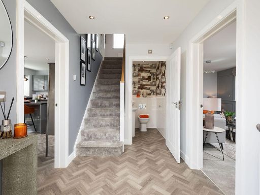 4 bedroom detached house for sale in Beverley,
East Yorkshire,
HU17 ONJ, HU17 — £414,995 • 4 bed • 1 bath • 1338 ft²
4 bedroom detached house for sale in Beverley,
East Yorkshire,
HU17 ONJ, HU17 — £414,995 • 4 bed • 1 bath • 1338 ft²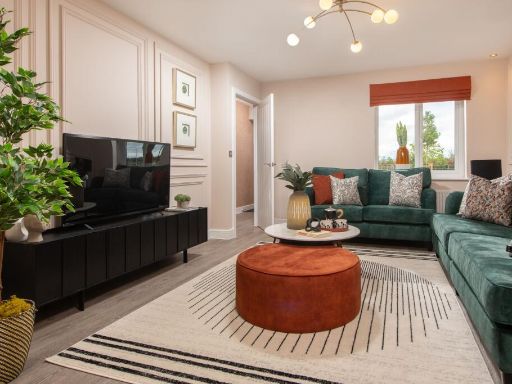 4 bedroom detached house for sale in Beverley,
East Yorkshire,
HU17 ONJ, HU17 — £374,995 • 4 bed • 1 bath • 1133 ft²
4 bedroom detached house for sale in Beverley,
East Yorkshire,
HU17 ONJ, HU17 — £374,995 • 4 bed • 1 bath • 1133 ft² 4 bedroom detached house for sale in Beverley,
East Yorkshire,
HU17 ONJ, HU17 — £374,995 • 4 bed • 1 bath • 1133 ft²
4 bedroom detached house for sale in Beverley,
East Yorkshire,
HU17 ONJ, HU17 — £374,995 • 4 bed • 1 bath • 1133 ft² 3 bedroom detached house for sale in Beverley,
East Yorkshire,
HU17 ONJ, HU17 — £349,995 • 3 bed • 1 bath • 1061 ft²
3 bedroom detached house for sale in Beverley,
East Yorkshire,
HU17 ONJ, HU17 — £349,995 • 3 bed • 1 bath • 1061 ft² 4 bedroom detached house for sale in Beverley,
East Yorkshire,
HU17 ONJ, HU17 — £389,995 • 4 bed • 1 bath • 1292 ft²
4 bedroom detached house for sale in Beverley,
East Yorkshire,
HU17 ONJ, HU17 — £389,995 • 4 bed • 1 bath • 1292 ft²
Meta
- {
"@context": "https://schema.org",
"@type": "Residence",
"name": "4 bedroom detached house for sale in Beverley, East Yorkshi…",
"description": "",
"url": "https://propertypiper.co.uk/property/4ddbb080-b855-41a8-9fc9-0b5f5c93c6f2",
"image": "https://image-a.propertypiper.co.uk/eb2df8dc-1a18-4796-b556-bfc84d05a1a4-1024.jpeg",
"address": {
"@type": "PostalAddress",
"streetAddress": "Beverley, \r\nEast Yorkshire,\r\nHU17 ONJ",
"postalCode": "HU17 0XG",
"addressLocality": "East Riding of Yorkshire",
"addressRegion": "Beverley and Holderness",
"addressCountry": "England"
},
"geo": {
"@type": "GeoCoordinates",
"latitude": 53.832192274000775,
"longitude": -0.4261700306293875
},
"numberOfRooms": 4,
"numberOfBathroomsTotal": 1,
"floorSize": {
"@type": "QuantitativeValue",
"value": 1528,
"unitCode": "FTK"
},
"offers": {
"@type": "Offer",
"price": 464995,
"priceCurrency": "GBP",
"availability": "https://schema.org/InStock"
},
"additionalProperty": [
{
"@type": "PropertyValue",
"name": "Feature",
"value": "modern"
},
{
"@type": "PropertyValue",
"name": "Feature",
"value": "living room"
},
{
"@type": "PropertyValue",
"name": "Feature",
"value": "large windows"
},
{
"@type": "PropertyValue",
"name": "Feature",
"value": "natural light"
},
{
"@type": "PropertyValue",
"name": "Feature",
"value": "neutral colors"
},
{
"@type": "PropertyValue",
"name": "Feature",
"value": "decorative lighting"
},
{
"@type": "PropertyValue",
"name": "Feature",
"value": "modern"
},
{
"@type": "PropertyValue",
"name": "Feature",
"value": "detached"
},
{
"@type": "PropertyValue",
"name": "Feature",
"value": "contemporary"
},
{
"@type": "PropertyValue",
"name": "Feature",
"value": "two-story"
},
{
"@type": "PropertyValue",
"name": "Feature",
"value": "new-build"
},
{
"@type": "PropertyValue",
"name": "Feature",
"value": "brick exterior"
},
{
"@type": "PropertyValue",
"name": "Feature",
"value": "lawn"
},
{
"@type": "PropertyValue",
"name": "Feature",
"value": "garage"
},
{
"@type": "PropertyValue",
"name": "Feature",
"value": "large windows"
}
]
}
High Res Floorplan Images
Compatible Floorplan Images
FloorplanImages Thumbnail