PR3 3YA - Land for sale in Ribchester Road, Ribchester, Preston, PR3
View on Property Piper
Land for sale in Ribchester Road, Ribchester, Preston, PR3
Property Details
- Price: £50000
- Bedrooms: 1
- Bathrooms: 1
- Property Type: undefined
- Property SubType: undefined
Brochure Descriptions
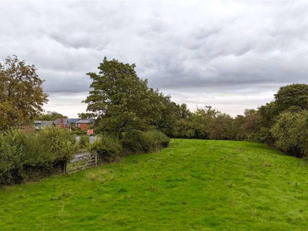
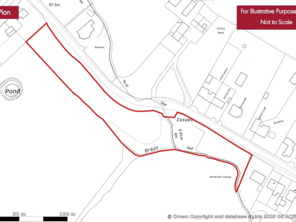
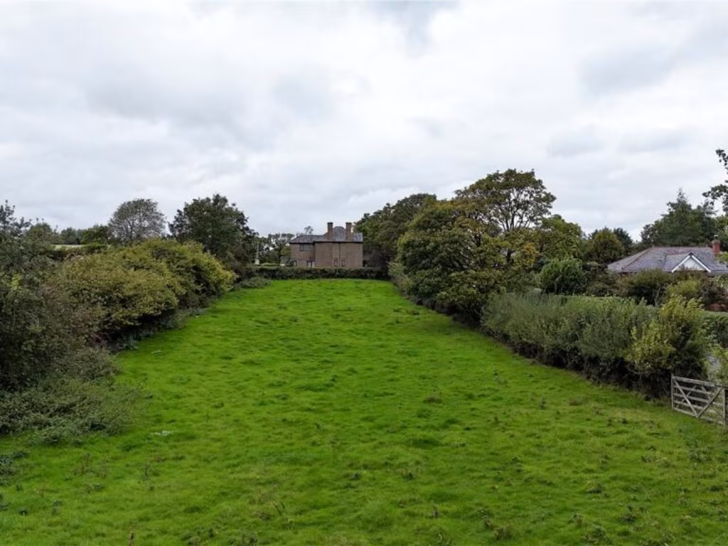
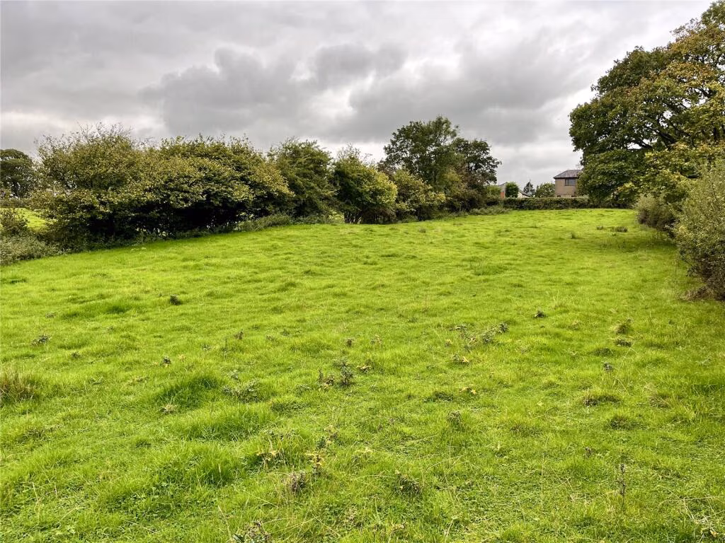
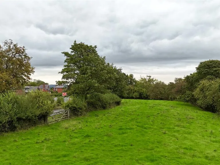
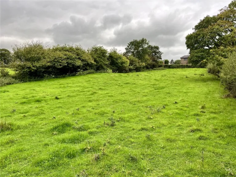
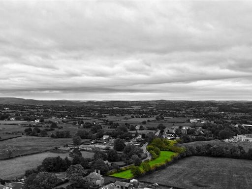
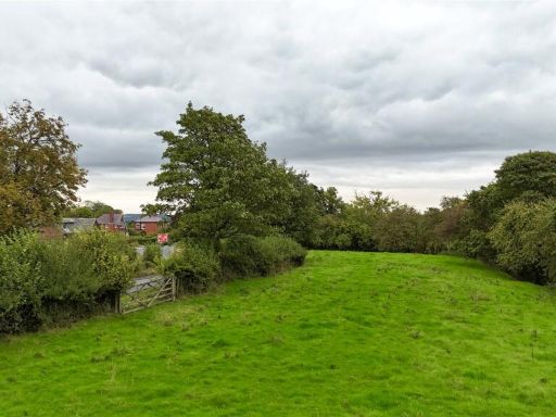
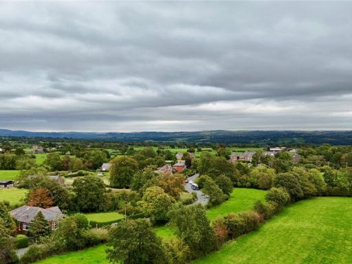
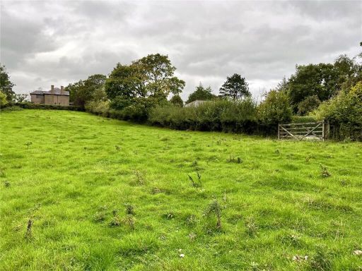
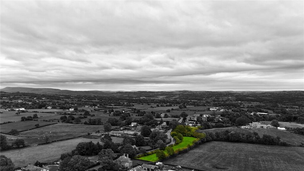
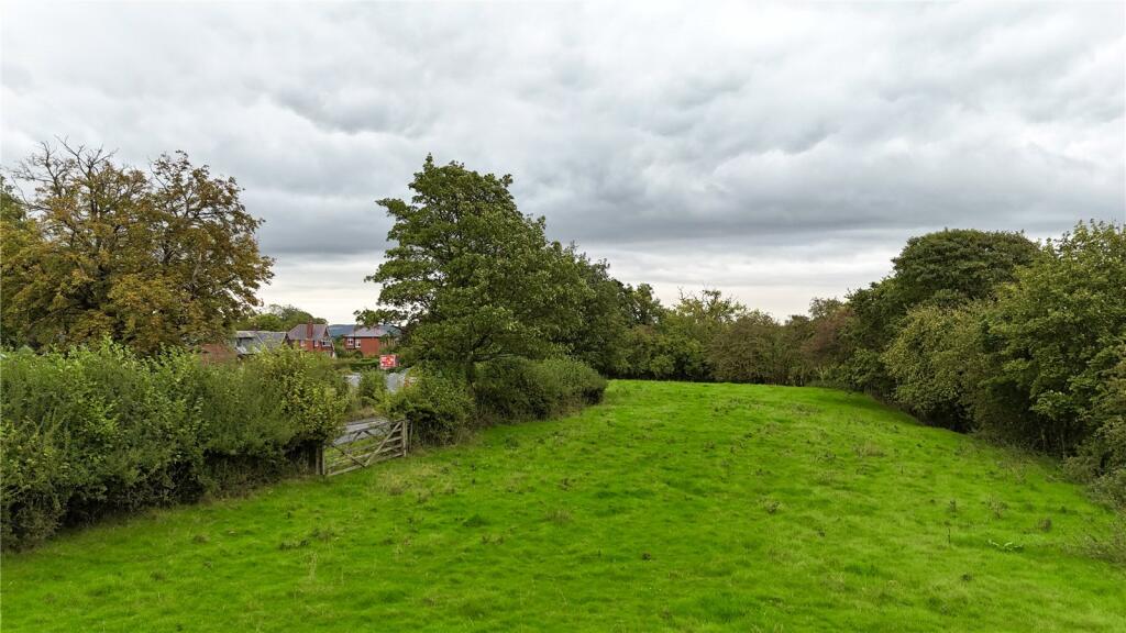
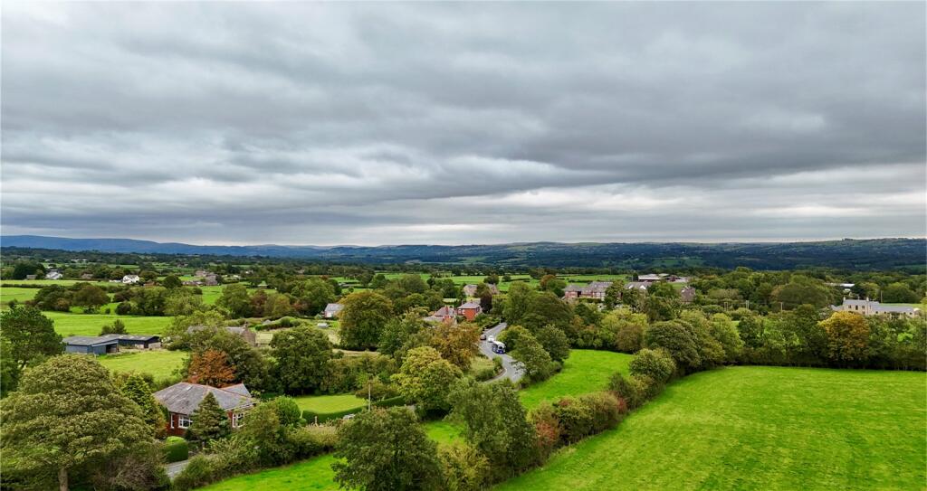
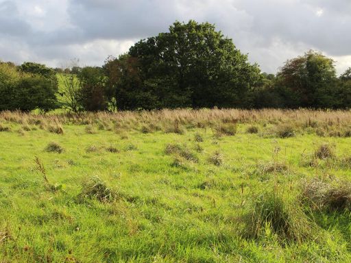
- Valuer-style description: A long, narrow parcel of greenfield land located off Ribchester Road on the edge of Ribchester village (PR3 3YA). The plot is predominantly grassed with a mature tree belt along much of its boundary, forming a sheltered, linear site that follows a minor watercourse or hedge line. The setting is rural with extensive open countryside and distant rolling hill views; the parcel sits adjacent to existing village development to one side and farmland to the other. The land appears suitable for agricultural, amenity or potential restricted development/infill subject to planning, and would appeal to purchasers seeking a countryside plot close to village services. Plot shape: linear/irregular; size: medium (cannot be precisely measured from the image). No buildings are visible on the site.
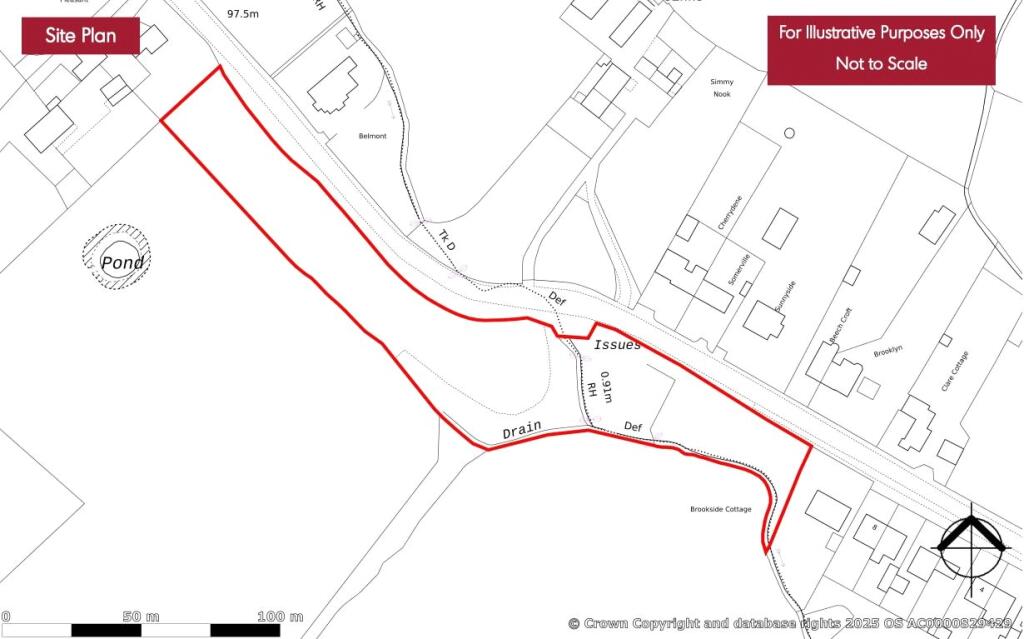
- Document appears to be an Armitstead Barnett listing/particulars page with much of the central address and property details redacted. No clear residential property address or photos of the dwelling are visible in the image. As a result it is not possible to describe the dwelling (type, number of bedrooms, internal layout) or to infer precise size. From the layout this looks like a single-property particulars/valuation document rather than photographic marketing, and key fields appear blacked out. Recommend obtaining the unredacted particulars or photographs to enable a professional valuation description.
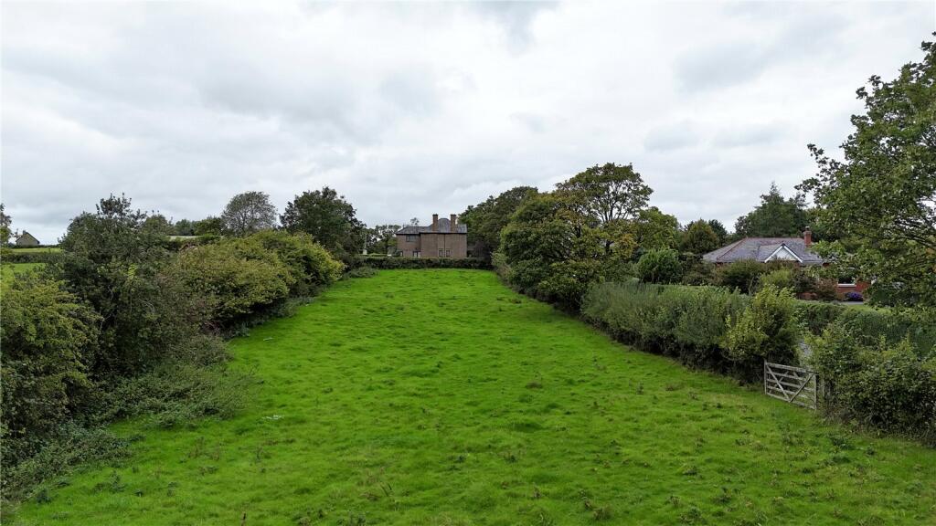
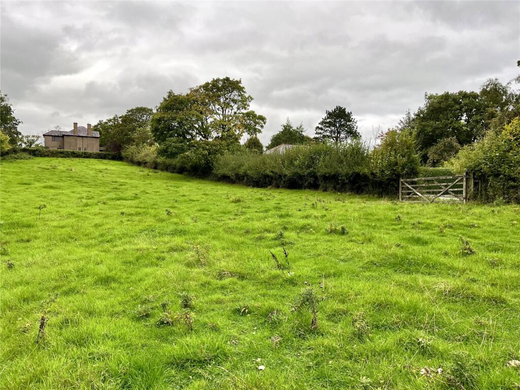
- Semi-improved grass paddock with adjoining scrub/woodland extending to 1.94 acres (0.79 hectares). The parcel benefits from roadside frontage and vehicular access off Ribchester Road and appears level to gently undulating, with natural watering available. Open rural aspect with views across adjoining pasture and mature hedgerow/trees providing shelter and boundary definition. Suitable for equestrian, amenity grazing or small-scale agricultural use; vacant possession is available upon completion. Overall plot size is large for a single paddock; no buildings or internal fixtures are evident in the images.
Image Descriptions
- rural landscape
- land/plot
Textual Property Features
Detected Visual Features
- rural
- countryside
- landscape
- greenery
- fields
- village
- land
- plot
- vacant
- green field
- development opportunity
- investment
- agriculture
Nearby Schools
- Lammack Primary School
- Longridge Church of England Primary School
- St Francis Catholic Primary School, Goosnargh
- Brockholes Wood Community Primary School and Nursery
- Mellor St Mary Church of England Primary School
- St Mary's Roman Catholic Primary School, Osbaldeston
- Preston Grange Primary School
- Ribchester St Wilfrid's Church of England Voluntary Aided Primary School
- Samlesbury Church of England School
- The Blessed Sacrament Catholic Primary School, Preston
- Moor Nook Community Primary School
- St Cecilia's RC High School
- Longridge High School
- Goosnargh Oliverson's Church of England Primary School
- Salesbury Church of England Primary School
- St Joseph's Roman Catholic Primary School, Hurst Green
- Sacred Heart Roman Catholic Primary School Blackburn
- Tauheedul Islam Girls' High School
- St Maria Goretti Catholic Primary School, Preston
- Highfield Priory School
- Balderstone St Leonard's Church of England Voluntary Aided Primary School
- Grimsargh St Michael's Church of England Primary School
- Longridge St Wilfrid's Roman Catholic Primary School
- Brabins Endowed School
- St Mary's Roman Catholic Primary School, Chipping
Nearest Bars And Restaurants
- Id: 308298219
- Tags:
- Amenity: pub
- Name: Old Oak
- TagsNormalized:
- Lat: 53.8228207
- Lon: -2.6069709
- FullGeoHash: gcw4hwjsthvx
- PartitionGeoHash: gcw4
- Images:
- FoodStandards: null
- Distance: 2459
,- Id: 307745720
- Tags:
- Amenity: pub
- Name: The Towneley Arms
- TagsNormalized:
- Lat: 53.8317629
- Lon: -2.6038581
- FullGeoHash: gcw4hxzbtxyt
- PartitionGeoHash: gcw4
- Images:
- FoodStandards: null
- Distance: 2339.8
,- Id: 307745715
- Tags:
- Amenity: pub
- Name: The Durham Ox
- TagsNormalized:
- Lat: 53.8305356
- Lon: -2.6013348
- FullGeoHash: gcw4hz9c8e0h
- PartitionGeoHash: gcw4
- Images:
- FoodStandards: null
- Distance: 2142.9
,- Id: 307745707
- Tags:
- Amenity: pub
- Name: The Dog Inn
- TagsNormalized:
- Lat: 53.829789
- Lon: -2.599223
- FullGeoHash: gcw4hz7m1xyz
- PartitionGeoHash: gcw4
- Images:
- FoodStandards: null
- Distance: 1988
,- Id: 626110765
- Tags:
- Amenity: pub
- Name: Corporation Arms
- TagsNormalized:
- Lat: 53.8307941
- Lon: -2.5819465
- FullGeoHash: gcw4jpxgh734
- PartitionGeoHash: gcw4
- Images:
- FoodStandards: null
- Distance: 987.7
}
Nearest Grocery shops
- Id: 9152359856
- Tags:
- Brand: Spar
- Brand:wikidata: Q610492
- Brand:wikipedia: en:SPAR (retailer)
- Name: Spar
- Shop: convenience
- TagsNormalized:
- Lat: 53.8128354
- Lon: -2.5336469
- FullGeoHash: gcw4nk743xxf
- PartitionGeoHash: gcw4
- Images:
- FoodStandards: null
- Distance: 2762.2
,- Id: 4665757255
- Tags:
- Brand: Premier
- Brand:wikidata: Q7240340
- Brand:wikipedia: en:Premier Stores
- Name: Premier
- Shop: convenience
- TagsNormalized:
- Lat: 53.821999
- Lon: -2.6094567
- FullGeoHash: gcw4htgzg7b1
- PartitionGeoHash: gcw4
- Images:
- FoodStandards: null
- Distance: 2633.2
,- Id: 761162729
- Tags:
- Brand: Co-op Food
- Brand:wikidata: Q3277439
- Brand:wikipedia: en:Co-op Food
- Name: Co-op Food
- Operator: The Co-operative Group
- Operator:wikidata: Q117202
- Shop: convenience
- TagsNormalized:
- co-op
- co-op food
- food
- convenience
- shop
- Lat: 53.8312371
- Lon: -2.6030392
- FullGeoHash: gcw4hz8t8vcm
- PartitionGeoHash: gcw4
- Images:
- FoodStandards: null
- Distance: 2271.5
}
Nearest Supermarkets
- Id: 8264523869
- Tags:
- Brand: ALDI
- Brand:wikidata: Q41171672
- Brand:wikipedia: en:Aldi
- Contact:
- Website: https://stores.aldi.co.uk/longridge/the-ridings
- Name: ALDI
- Shop: supermarket
- TagsNormalized:
- Lat: 53.8298804
- Lon: -2.6108119
- FullGeoHash: gcw4hx6vg9j8
- PartitionGeoHash: gcw4
- Images:
- FoodStandards: null
- Distance: 2734.7
,- Id: 736396070
- Tags:
- Brand: Sainsbury's
- Brand:wikidata: Q152096
- Brand:wikipedia: en:Sainsbury's
- Name: Sainsbury's
- Shop: supermarket
- TagsNormalized:
- sainsburys
- supermarket
- shop
- Lat: 53.8355925
- Lon: -2.6065943
- FullGeoHash: gcw4k8mzjcy6
- PartitionGeoHash: gcw4
- Images:
- FoodStandards: null
- Distance: 2660.5
,- Id: 736396115
- Tags:
- Addr:
- City: Longridge
- Country: GB
- Postcode: PR3 3NH
- Street: Berry Lane
- Brand: Booths
- Brand:wikidata: Q4943949
- Brand:wikipedia: en:Booths
- Contact:
- Website: https://www.booths.co.uk/store/preston-longridge/
- Fhrs:
- Name: Booths
- Shop: supermarket
- TagsNormalized:
- Lat: 53.8329162
- Lon: -2.6048366
- FullGeoHash: gcw4hxzpqyvj
- PartitionGeoHash: gcw4
- Images:
- FoodStandards:
- Id: 105505
- FHRSID: 105505
- LocalAuthorityBusinessID: 36281
- BusinessName: Booths Service Station
- BusinessType: Retailers - other
- BusinessTypeID: 4613
- AddressLine1: Central Garage
- AddressLine2: Berry Lane
- AddressLine3: Longridge
- AddressLine4: Preston, Lancashire
- PostCode: PR3 3NH
- RatingValue: 5
- RatingKey: fhrs_5_en-GB
- RatingDate: 2019-10-16
- LocalAuthorityCode: 203
- LocalAuthorityName: Ribble Valley
- LocalAuthorityWebSite: http://www.ribblevalley.gov.uk
- LocalAuthorityEmailAddress: environmentalhealth@ribblevalley.gov.uk
- Scores:
- Hygiene: 0
- Structural: 0
- ConfidenceInManagement: 0
- NewRatingPending: false
- Geocode:
- Longitude: -2.60548800000000
- Latitude: 53.83245300000000
- Distance: 2441.1
}
Nearest Religious buildings
- Id: 307745713
- Tags:
- Amenity: place_of_worship
- Denomination: methodist
- Name: Christ Church
- Religion: christian
- TagsNormalized:
- place of worship
- methodist
- church
- christian
- Lat: 53.8304614
- Lon: -2.6012132
- FullGeoHash: gcw4hz9c5m6f
- PartitionGeoHash: gcw4
- Images:
- FoodStandards: null
- Distance: 2133
,- Id: 59377373
- Tags:
- Amenity: place_of_worship
- Building: church
- Denomination: anglican
- Name: St Paul's Church
- Religion: christian
- Source: OS_OpenData_StreetView
- Wikidata: Q20876729
- TagsNormalized:
- place of worship
- church
- anglican
- christian
- Lat: 53.8313403
- Lon: -2.6000352
- FullGeoHash: gcw4hzdwqc1h
- PartitionGeoHash: gcw4
- Images:
- FoodStandards: null
- Distance: 2086.4
,- Id: 59377369
- Tags:
- Amenity: place_of_worship
- Building: church
- Denomination: anglican
- Name: St Lawrence
- Religion: christian
- Source: OS_OpenData_StreetView
- Wikidata: Q102328757
- TagsNormalized:
- place of worship
- church
- anglican
- christian
- Lat: 53.8253024
- Lon: -2.601028
- FullGeoHash: gcw4hy9gpesg
- PartitionGeoHash: gcw4
- Images:
- FoodStandards: null
- Distance: 2050.2
}
Nearest Medical buildings
- Id: 703055168
- Tags:
- Amenity: doctors
- Healthcare: doctor
- Name: Stonebridge Surgery
- TagsNormalized:
- doctor
- doctors
- health
- healthcare
- surgery
- Lat: 53.828058
- Lon: -2.6080237
- FullGeoHash: gcw4hxhghtk9
- PartitionGeoHash: gcw4
- Images:
- FoodStandards: null
- Distance: 2524.5
,- Id: 703055166
- Tags:
- Amenity: pharmacy
- Brand: Well Pharmacy
- Brand:wikidata: Q7726524
- Brand:wikipedia: en:Well Pharmacy
- Dispensing: yes
- Healthcare: pharmacy
- Name: Well Pharmacy
- TagsNormalized:
- pharmacy
- well pharmacy
- health
- healthcare
- Lat: 53.8284344
- Lon: -2.6079054
- FullGeoHash: gcw4hxhvr7ky
- PartitionGeoHash: gcw4
- Images:
- FoodStandards: null
- Distance: 2521.7
,- Id: 703055179
- Tags:
- Amenity: doctors
- Healthcare: doctor
- Name: Berry Lane Medical Centre
- TagsNormalized:
- doctor
- doctors
- health
- healthcare
- Lat: 53.8308742
- Lon: -2.603621
- FullGeoHash: gcw4hz85e4r2
- PartitionGeoHash: gcw4
- Images:
- FoodStandards: null
- Distance: 2297.5
,- Id: 8746886255
- Tags:
- Amenity: pharmacy
- Brand: Lloyds Pharmacy
- Brand:wikidata: Q6662870
- Brand:wikipedia: en:LloydsPharmacy
- Dispensing: yes
- Healthcare: pharmacy
- Name: Lloyds Pharmacy
- TagsNormalized:
- pharmacy
- lloyds pharmacy
- health
- healthcare
- Lat: 53.8315057
- Lon: -2.6027861
- FullGeoHash: gcw4hz8xnxyp
- PartitionGeoHash: gcw4
- Images:
- FoodStandards: null
- Distance: 2264.1
}
Nearest Leisure Facilities
- Id: 1053959975
- Tags:
- TagsNormalized:
- Lat: 53.8353562
- Lon: -2.5924101
- FullGeoHash: gcw4m02m8myb
- PartitionGeoHash: gcw4
- Images:
- FoodStandards: null
- Distance: 1841.4
,- Id: 894547252
- Tags:
- TagsNormalized:
- outdoor
- outdoor seating
- leisure
- Lat: 53.8374208
- Lon: -2.5839508
- FullGeoHash: gcw4m0y3twds
- PartitionGeoHash: gcw4
- Images:
- FoodStandards: null
- Distance: 1613.8
,- Id: 1053960894
- Tags:
- TagsNormalized:
- Lat: 53.829031
- Lon: -2.5917648
- FullGeoHash: gcw4jp28zd8j
- PartitionGeoHash: gcw4
- Images:
- FoodStandards: null
- Distance: 1492.9
,- Id: 696198387
- Tags:
- TagsNormalized:
- Lat: 53.8136677
- Lon: -2.5683948
- FullGeoHash: gcw4js3z24dp
- PartitionGeoHash: gcw4
- Images:
- FoodStandards: null
- Distance: 1324.9
,- Id: 696198394
- Tags:
- TagsNormalized:
- Lat: 53.8140732
- Lon: -2.5708111
- FullGeoHash: gcw4jkxcxy26
- PartitionGeoHash: gcw4
- Images:
- FoodStandards: null
- Distance: 1278.4
}
Nearest Tourist attractions
- Id: 528743494
- Tags:
- Building: museum
- Name: Roman Museum
- Tourism: museum
- TagsNormalized:
- Lat: 53.8104865
- Lon: -2.5325958
- FullGeoHash: gcw4n7guf1xx
- PartitionGeoHash: gcw4
- Images:
- FoodStandards: null
- Distance: 2961.3
,- Id: 895238358
- Tags:
- TagsNormalized:
- Lat: 53.8200363
- Lon: -2.5463249
- FullGeoHash: gcw4nj9u6mft
- PartitionGeoHash: gcw4
- Images:
- FoodStandards: null
- Distance: 1658.1
,- Id: 894547244
- Tags:
- Name: Beacon Fell View Holiday Village
- Tourism: caravan_site
- TagsNormalized:
- Lat: 53.8367623
- Lon: -2.5860203
- FullGeoHash: gcw4m0svv7gs
- PartitionGeoHash: gcw4
- Images:
- FoodStandards: null
- Distance: 1639.3
}
Nearest Train stations
- Id: 3711617684
- Tags:
- Name: Pleasington
- Naptan:
- Network: National Rail
- Public_transport: station
- Railway: station
- Ref:
- Request_stop: yes
- Train: yes
- Wikidata: Q3306245
- Wikipedia: en:Pleasington railway station
- TagsNormalized:
- Lat: 53.7310487
- Lon: -2.5440104
- FullGeoHash: gcw1wj7w032q
- PartitionGeoHash: gcw1
- Images:
- FoodStandards: null
- Distance: 10644.2
,- Id: 4977730957
- Tags:
- Name: Blackburn
- Naptan:
- Network: National Rail
- Operator: Northern
- Public_transport: station
- Railway: station
- Ref:
- Train: yes
- Wikidata: Q2726049
- Wikipedia: en:Blackburn railway station
- TagsNormalized:
- Lat: 53.7463745
- Lon: -2.4790853
- FullGeoHash: gcw1z84z34kh
- PartitionGeoHash: gcw1
- Images:
- FoodStandards: null
- Distance: 10631.4
,- Id: 5063999843
- Tags:
- Name: Whalley
- Naptan:
- Network: National Rail
- Operator: Northern
- Public_transport: station
- Railway: station
- Ref:
- Train: yes
- Wikidata: Q3453912
- Wikipedia: en:Whalley railway station
- TagsNormalized:
- Lat: 53.8244874
- Lon: -2.4118943
- FullGeoHash: gcw61n7wqg9m
- PartitionGeoHash: gcw6
- Images:
- FoodStandards: null
- Distance: 10364.1
,- Id: 21664753
- Tags:
- Name: Langho
- Naptan:
- Network: National Rail
- Public_transport: station
- Railway: station
- Ref:
- Source: NPE
- Train: yes
- Wikipedia: en:Langho railway station
- TagsNormalized:
- Lat: 53.8048112
- Lon: -2.4488239
- FullGeoHash: gcw606bgdrb8
- PartitionGeoHash: gcw6
- Images:
- FoodStandards: null
- Distance: 8269.6
,- Id: 2185022486
- Tags:
- Name: Ramsgreave and Wilpshire
- Naptan:
- Network: National Rail
- Platforms: 2
- Public_transport: station
- Railway: station
- Ref:
- Train: yes
- Wikipedia: en:Ramsgreave and Wilpshire railway station
- TagsNormalized:
- Lat: 53.7799943
- Lon: -2.4780606
- FullGeoHash: gcw1zw7e1j84
- PartitionGeoHash: gcw1
- Images:
- FoodStandards: null
- Distance: 7871
}
Nearest Bus stations and stops
- Id: 626112102
- Tags:
- Bus: yes
- Highway: bus_stop
- Public_transport: platform
- TagsNormalized:
- Lat: 53.8293631
- Lon: -2.6077534
- FullGeoHash: gcw4hxm4fbw4
- PartitionGeoHash: gcw4
- Images:
- FoodStandards: null
- Distance: 2527.1
,- Id: 626111452
- Tags:
- Bus: yes
- Highway: bus_stop
- Public_transport: platform
- TagsNormalized:
- Lat: 53.8291643
- Lon: -2.6074975
- FullGeoHash: gcw4hxm38gsb
- PartitionGeoHash: gcw4
- Images:
- FoodStandards: null
- Distance: 2506.9
,- Id: 626111879
- Tags:
- Bus: yes
- Highway: bus_stop
- Public_transport: platform
- TagsNormalized:
- Lat: 53.829025
- Lon: -2.606725
- FullGeoHash: gcw4hxmbfcsc
- PartitionGeoHash: gcw4
- Images:
- FoodStandards: null
- Distance: 2454.4
,- Id: 626111336
- Tags:
- Bus: yes
- Highway: bus_stop
- Public_transport: platform
- TagsNormalized:
- Lat: 53.8311146
- Lon: -2.6023798
- FullGeoHash: gcw4hz9hbphf
- PartitionGeoHash: gcw4
- Images:
- FoodStandards: null
- Distance: 2226.2
,- Id: 626111448
- Tags:
- Bus: yes
- Highway: bus_stop
- Public_transport: platform
- TagsNormalized:
- Lat: 53.8298102
- Lon: -2.5996869
- FullGeoHash: gcw4hz6vqguv
- PartitionGeoHash: gcw4
- Images:
- FoodStandards: null
- Distance: 2018.2
}
Nearest Hotels
- Id: 128357560
- Tags:
- Amenity: pub
- Building: yes
- Name: Bayley Arms
- Tourism: hotel
- Wikidata: Q26644150
- TagsNormalized:
- Lat: 53.8386069
- Lon: -2.4808336
- FullGeoHash: gcw4r91887sr
- PartitionGeoHash: gcw4
- Images:
- FoodStandards: null
- Distance: 6015.4
,- Id: 137650321
- Tags:
- Addr:
- City: Balderstone
- Country: GB
- Postcode: BB2 7LE
- Street: Myerscough Road
- Building: yes
- Contact:
- Email: bluebird.inn@jwlees.co.uk
- Facebook: https://www.facebook.com/TheBluebirdInnSamlesbury
- Phone: +44 1254 813900
- Twitter: BluebirdInn_
- Website: https://www.bluebirdinn.co.uk/
- Name: Bluebird Inn
- Old_name: Premier Inn
- Tourism: hotel
- Wheelchair: yes
- TagsNormalized:
- Lat: 53.7760854
- Lon: -2.5803366
- FullGeoHash: gcw1vm9h3ucs
- PartitionGeoHash: gcw1
- Images:
- FoodStandards: null
- Distance: 5544.1
,- Id: 309633935
- Tags:
- TagsNormalized:
- Lat: 53.7798908
- Lon: -2.5385816
- FullGeoHash: gcw1ynr6wf22
- PartitionGeoHash: gcw1
- Images:
- FoodStandards: null
- Distance: 5475.6
}
Tags
- rural
- countryside
- landscape
- greenery
- fields
- village
- land
- plot
- vacant
- green field
- development opportunity
- rural
- countryside
- investment
- agriculture
Local Market Stats
- Average Price/sqft: £233
- Avg Income: £45300
- Rental Yield: 3.9%
- Social Housing: 5%
- Planning Success Rate: 82%
Similar Properties
 Farm land for sale in Clayton Le Dale, Blackburn , BB2 — £25,000 • 1 bed • 1 bath
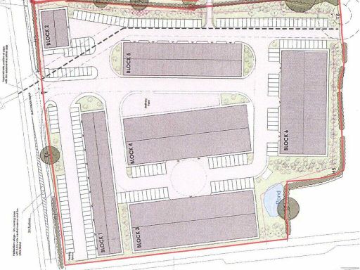 Land for sale in Land south of Blackburn Road, Hothersall, Longridge, PR3 2YY, PR3 — £2,000,000 • 1 bed • 1 bath • 20000 ft²
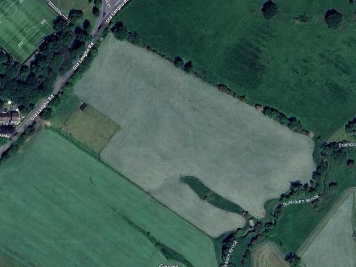 Land for sale in Old Langho Road, Old Langho, Ribble Valley, BB6 — £200,000 • 1 bed • 1 bath • 770 ft²
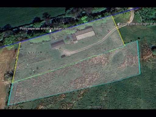 Land for sale in Helms Deep, Long Lane, Barnacre, Garstang, Lancashire, PR3 1RN, PR3 — £325,000 • 1 bed • 1 bath • 2507 ft²
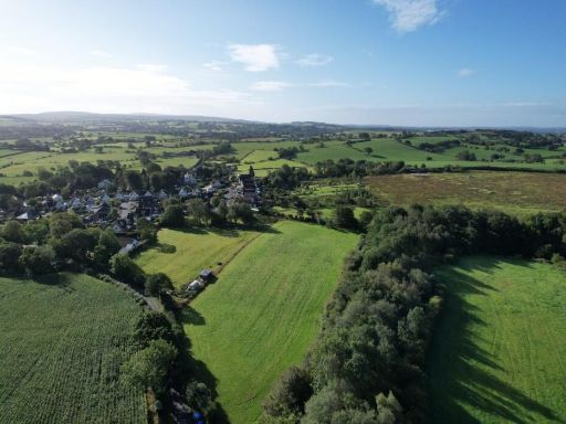 Land for sale in Smithy Lane, PR6 — £50,000 • 1 bed • 1 bath
 Land for sale in Land At Barrow Brook Business Park , Clitheroe , BB7 9WF, BB7 — £8,000,000 • 1 bed • 1 bath
Meta
- {
"@context": "https://schema.org",
"@type": "Residence",
"name": "Land for sale in Ribchester Road, Ribchester, Preston, PR3",
"description": "",
"url": "https://propertypiper.co.uk/property/402234bc-c785-4902-ab54-e0918bfa3294",
"image": "https://image-a.propertypiper.co.uk/a9f27d82-258f-49af-aab8-f39dc77a9440-1024.jpeg",
"address": {
"@type": "PostalAddress",
"streetAddress": "BROOKLYN RIBCHESTER ROAD RIBCHESTER PRESTON",
"postalCode": "PR3 3YA",
"addressLocality": "Ribble Valley",
"addressRegion": "Ribble Valley",
"addressCountry": "England"
},
"geo": {
"@type": "GeoCoordinates",
"latitude": 53.825554440635976,
"longitude": -2.5697930359544734
},
"numberOfRooms": 1,
"numberOfBathroomsTotal": 1,
"offers": {
"@type": "Offer",
"price": 50000,
"priceCurrency": "GBP",
"availability": "https://schema.org/InStock"
},
"additionalProperty": [
{
"@type": "PropertyValue",
"name": "Feature",
"value": "rural"
},
{
"@type": "PropertyValue",
"name": "Feature",
"value": "countryside"
},
{
"@type": "PropertyValue",
"name": "Feature",
"value": "landscape"
},
{
"@type": "PropertyValue",
"name": "Feature",
"value": "greenery"
},
{
"@type": "PropertyValue",
"name": "Feature",
"value": "fields"
},
{
"@type": "PropertyValue",
"name": "Feature",
"value": "village"
},
{
"@type": "PropertyValue",
"name": "Feature",
"value": "land"
},
{
"@type": "PropertyValue",
"name": "Feature",
"value": "plot"
},
{
"@type": "PropertyValue",
"name": "Feature",
"value": "vacant"
},
{
"@type": "PropertyValue",
"name": "Feature",
"value": "green field"
},
{
"@type": "PropertyValue",
"name": "Feature",
"value": "development opportunity"
},
{
"@type": "PropertyValue",
"name": "Feature",
"value": "rural"
},
{
"@type": "PropertyValue",
"name": "Feature",
"value": "countryside"
},
{
"@type": "PropertyValue",
"name": "Feature",
"value": "investment"
},
{
"@type": "PropertyValue",
"name": "Feature",
"value": "agriculture"
}
]
}