TQ14 9SA - Land for sale in Bishopsteignton, Teignmouth, TQ14
View on Property Piper
Land for sale in Bishopsteignton, Teignmouth, TQ14
Property Details
- Price: £125000
- Bedrooms: 1
- Bathrooms: 1
- Property Type: undefined
- Property SubType: undefined
Brochure Descriptions
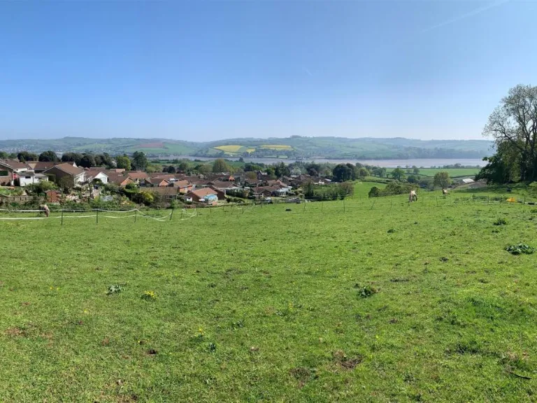
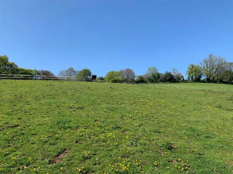
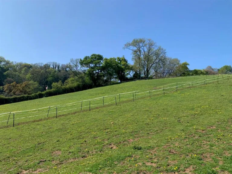
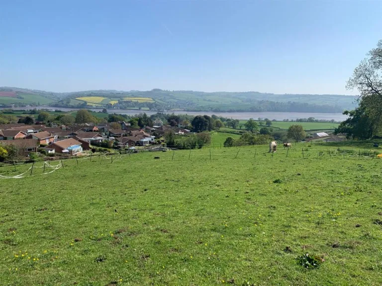
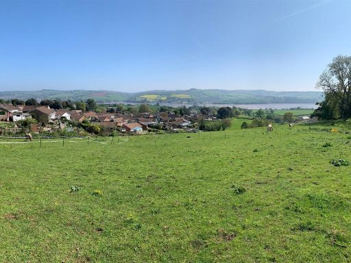
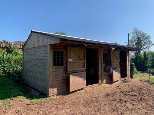
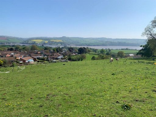
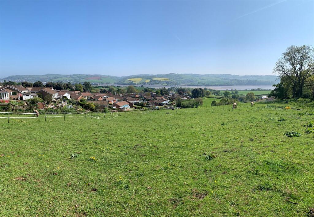
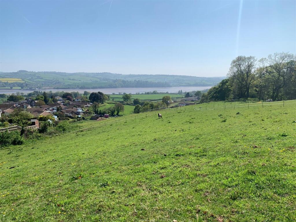
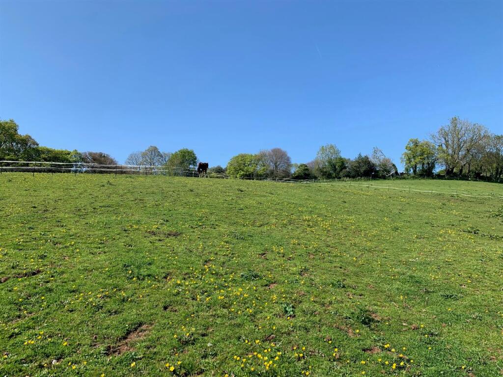
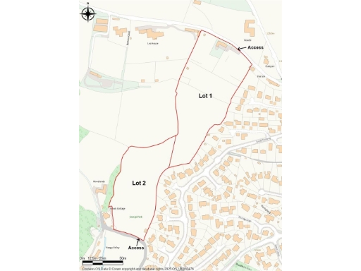
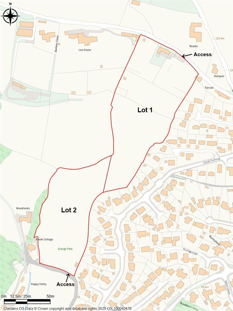
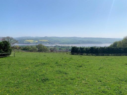
- This property offers approximately 4.10 acres of verdant pasture land situated close to the Bishopsteignton settlement limit. The property includes modern stables making it ideal for equestrian use. The land is located in a picturesque village setting offering beautiful estuary views that enhance its desirability. The land features two field shelters, providing shelter for horses or livestock. The lot is of average size for grazing with proximity to essential amenities such as mains water supply. The setting provides serene rural views with a backdrop of lush rolling hills.
Image Descriptions
- countryside view
- stable building rustic
Floorplan Description
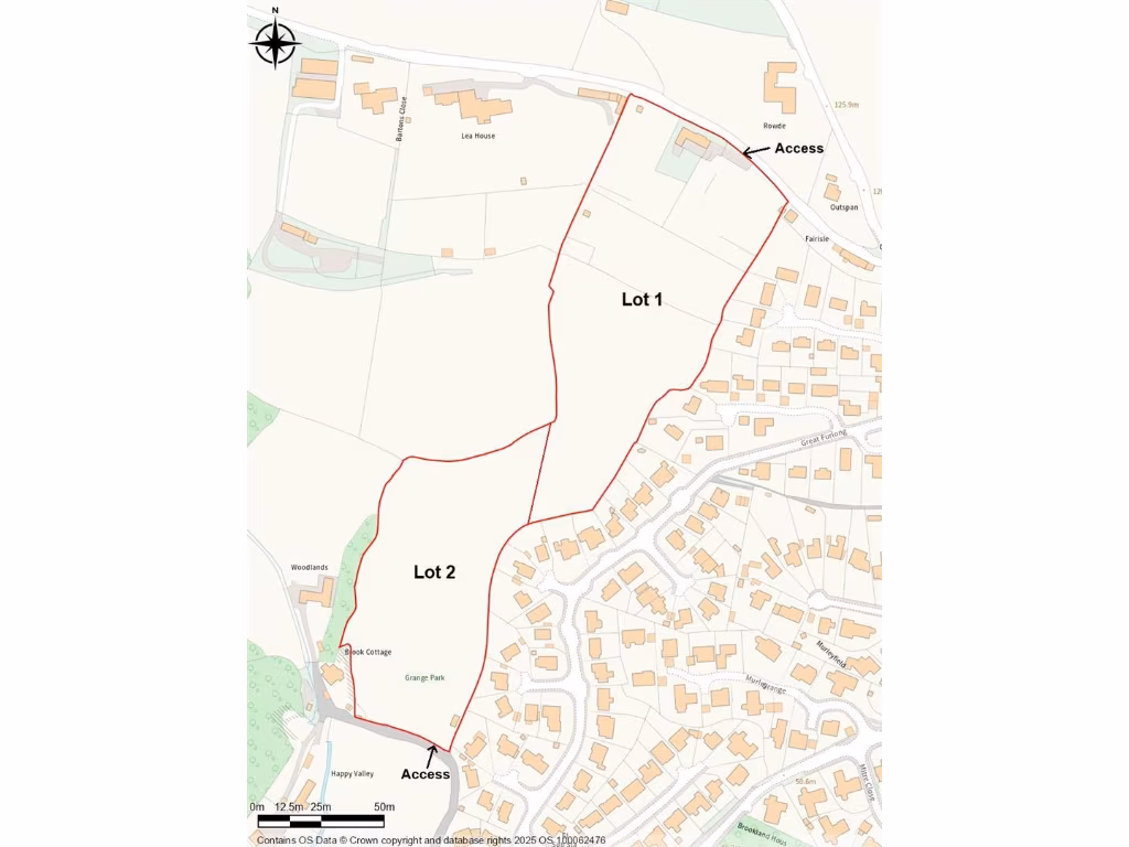
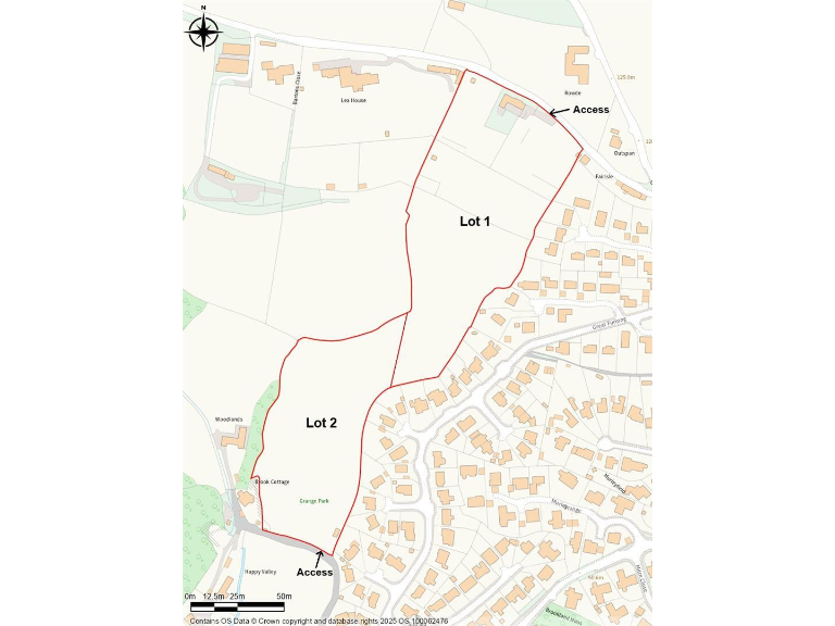
- The image shows a map with two lots (Lot 1 and Lot 2) and access points marked.
Textual Property Features
Detected Visual Features
- countryside
- landscape
- rural
- scenic
- fields
- hills
- nature
- pastoral
- stable
- wooden
- rustic
- outbuilding
- agricultural
- barn
Nearby Schools
- The Lodestar Academy
- Watcombe Primary School
- Wolborough Church of England Nursery and Primary School
- Bearnes Voluntary Primary School
- Coombeshead Academy
- Teignmouth Community School, Exeter Road
- Trinity School
- Hazeldown School
- Decoy Primary School
- St Michael's Church of England Primary School
- Rydon Primary School
- Kingsteignton School
- Chudleigh Church of England Community Primary School
- Haytor View Community Primary School
- Newton Abbot College
- South Devon UTC
- St Joseph's Catholic Primary School
- Shaldon Primary School
- Bishopsteignton School
- Teign School
- Teignmouth Primary School
- Barton Hill Academy
- Kingskerswell Church of England Primary School
- Stokeinteignhead School
- Highweek Community Primary and Nursery School
- All Saints Marsh CofE Academy
- Our Lady and St Patrick's Roman Catholic Primary School
Nearest Bars And Restaurants
- Id: 5696058274
- Tags:
- Amenity: pub
- Name: The Wild Goose Inn
- Wheelchair: no
- Wikidata: Q80476649
- TagsNormalized:
- Lat: 50.5333422
- Lon: -3.5501277
- FullGeoHash: gbvrrpqfh18z
- PartitionGeoHash: gbvr
- Images:
- FoodStandards: null
- Distance: 2220.4
,- Id: 118783918
- Tags:
- Amenity: pub
- Building: yes
- Name: Coombe Cellars Inn
- Wikidata: Q5167590
- Wikipedia: en:Coombe Cellars
- TagsNormalized:
- Lat: 50.5409695
- Lon: -3.5510115
- FullGeoHash: gbvrx0wnrrtf
- PartitionGeoHash: gbvr
- Images:
- FoodStandards: null
- Distance: 1373.4
,- Id: 493531114
- Tags:
- Amenity: pub
- Name: Ring O'Bells
- Wikidata: Q79684409
- TagsNormalized:
- Lat: 50.553152
- Lon: -3.5390427
- FullGeoHash: gbvrx6yvqqd3
- PartitionGeoHash: gbvr
- Images:
- FoodStandards: null
- Distance: 1102.5
,- Id: 493552937
- Tags:
- Amenity: restaurant
- Name: Cockhaven Manor
- TagsNormalized:
- Lat: 50.5511586
- Lon: -3.541915
- FullGeoHash: gbvrx6scg6uy
- PartitionGeoHash: gbvr
- Images:
- FoodStandards: null
- Distance: 925.2
,- Id: 493412299
- Tags:
- Addr:
- City: Bishopsteignton
- Postcode: TQ14 9QS
- Street: Clanage Street
- Amenity: pub
- Name: Old Commercial Inn
- Wikidata: Q26618642
- TagsNormalized:
- Lat: 50.5541725
- Lon: -3.5433486
- FullGeoHash: gbvrx75g3uzc
- PartitionGeoHash: gbvr
- Images:
- FoodStandards: null
- Distance: 807.1
}
Nearest General Shops
- Id: 40631926
- Tags:
- Landuse: retail
- Name: Jack's Patch Garden Centre
- Shop: garden_centre
- TagsNormalized:
- Lat: 50.5470871
- Lon: -3.538967
- FullGeoHash: gbvrx3z405fz
- PartitionGeoHash: gbvr
- Images:
- FoodStandards: null
- Distance: 1294.2
,- Id: 493509236
- Tags:
- TagsNormalized:
- Lat: 50.5535725
- Lon: -3.5413853
- FullGeoHash: gbvrx6vpzszw
- PartitionGeoHash: gbvr
- Images:
- FoodStandards: null
- Distance: 938.5
,- Id: 1949580669
- Tags:
- Name: Metro Motors
- Shop: car
- TagsNormalized:
- Lat: 50.549735
- Lon: -3.5470118
- FullGeoHash: gbvrx631s9s6
- PartitionGeoHash: gbvr
- Images:
- FoodStandards: null
- Distance: 656.7
}
Nearest Grocery shops
- Id: 1139491578
- Tags:
- Brand: Londis
- Brand:wikidata: Q21008564
- Name: Londis
- Shop: convenience
- Wheelchair: yes
- TagsNormalized:
- Lat: 50.5467736
- Lon: -3.5962316
- FullGeoHash: gbvrw1v239x3
- PartitionGeoHash: gbvr
- Images:
- FoodStandards: null
- Distance: 3021.1
,- Id: 640444539
- Tags:
- Name: Kingsteignton Co-op
- Shop: convenience
- TagsNormalized:
- Lat: 50.5549152
- Lon: -3.5934321
- FullGeoHash: gbvrw5prdznz
- PartitionGeoHash: gbvr
- Images:
- FoodStandards: null
- Distance: 2747.4
,- Id: 493412312
- Tags:
- Name: Supply Stores
- Shop: convenience
- TagsNormalized:
- Lat: 50.5536821
- Lon: -3.5437535
- FullGeoHash: gbvrx758893u
- PartitionGeoHash: gbvr
- Images:
- FoodStandards: null
- Distance: 772.4
}
Nearest Supermarkets
- Id: 136387254
- Tags:
- Addr:
- City: Newton Abbot
- Postcode: TQ12 3RN
- Street: Newton Road
- Alt_name: Tesco Newton Abbot Kingsteignton Superstore
- Brand: Tesco
- Brand:wikidata: Q487494
- Building: yes
- Contact:
- Website: https://www.tesco.com/store-locator/newton-abbot/newton-rd
- Name: Tesco
- Shop: supermarket
- Toilets:
- Wheelchair: yes
- TagsNormalized:
- Lat: 50.5407563
- Lon: -3.6021932
- FullGeoHash: gbvrw08vnzf4
- PartitionGeoHash: gbvr
- Images:
- FoodStandards: null
- Distance: 3629.1
,- Id: 187777232
- Tags:
- Addr:
- City: Newton Abbot
- Postcode: TQ12 3AJ
- Street: Newton Road
- Alt_name: LIDL Kingsteignton
- Brand: Lidl
- Brand:wikidata: Q151954
- Brand:wikipedia: en:Lidl
- Building: yes
- Fhrs:
- Name: Lidl
- Shop: supermarket
- Wheelchair: yes
- TagsNormalized:
- Lat: 50.5454056
- Lon: -3.5973606
- FullGeoHash: gbvrw1s2r6t8
- PartitionGeoHash: gbvr
- Images:
- FoodStandards:
- Id: 31422
- FHRSID: 31422
- LocalAuthorityBusinessID: 09/00983/MIXED
- BusinessName: Lidl
- BusinessType: Retailers - supermarkets/hypermarkets
- BusinessTypeID: 7840
- AddressLine1: Newton Road Kingsteignton Devon
- AddressLine2: null
- AddressLine3: null
- AddressLine4: null
- PostCode: TQ12 3AJ
- RatingValue: 4
- RatingKey: fhrs_4_en-GB
- RatingDate: 2021-09-23
- LocalAuthorityCode: 078
- LocalAuthorityName: Teignbridge
- LocalAuthorityWebSite: http://www.teignbridge.gov.uk/fhrs
- LocalAuthorityEmailAddress: fhrs@teignbridge.gov.uk
- Scores:
- Hygiene: 5
- Structural: 10
- ConfidenceInManagement: 5
- NewRatingPending: false
- Geocode:
- Longitude: -3.59660700000000
- Latitude: 50.54622000000000
- Distance: 3136.9
,- Id: 302683573
- Tags:
- Addr:
- City: Teignmouth
- Housename: Morrisons
- Postcode: TQ14 9WP
- Street: Newfoundland Road
- Branch: Teignmouth
- Brand: Morrisons
- Brand:wikidata: Q922344
- Brand:wikipedia: en:Morrisons
- Building: yes
- Contact:
- Website: https://my.morrisons.com/storefinder/560
- Name: Morrisons
- Opening_hours: Mo-Sa 07:00-22:00; Su 10:00-16:00
- Shop: supermarket
- TagsNormalized:
- Lat: 50.5485913
- Lon: -3.5179881
- FullGeoHash: gbvrxfn6bumu
- PartitionGeoHash: gbvr
- Images:
- FoodStandards: null
- Distance: 2638.3
}
Nearest Religious buildings
- Id: 555723486
- Tags:
- Amenity: place_of_worship
- Building: church
- Denomination: anglican
- Name: All Saints' Chrch
- Religion: christian
- Wheelchair: limited
- Wikidata: Q17535134
- TagsNormalized:
- place of worship
- church
- anglican
- christian
- Lat: 50.5332687
- Lon: -3.5508895
- FullGeoHash: gbvrrpq3dk0c
- PartitionGeoHash: gbvr
- Images:
- FoodStandards: null
- Distance: 2221.4
,- Id: 555723485
- Tags:
- Amenity: place_of_worship
- Building: church
- Denomination: anglican
- Name: St John The Baptist
- Religion: christian
- Wikidata: Q17527273
- TagsNormalized:
- place of worship
- church
- anglican
- baptist
- christian
- Lat: 50.5510872
- Lon: -3.5385729
- FullGeoHash: gbvrx6x33m8u
- PartitionGeoHash: gbvr
- Images:
- FoodStandards: null
- Distance: 1157.6
,- Id: 636090973
- Tags:
- Amenity: place_of_worship
- Building: church
- Denomination: methodist
- Name: Bishopsteignton Methodist Church
- Religion: christian
- Source: os_opendata_openmaplocal
- TagsNormalized:
- place of worship
- church
- methodist
- christian
- Lat: 50.553916
- Lon: -3.5419878
- FullGeoHash: gbvrx7hccsyr
- PartitionGeoHash: gbvr
- Images:
- FoodStandards: null
- Distance: 899
}
Nearest Medical buildings
- Id: 575131023
- Tags:
- Amenity: doctors
- Wheelchair: yes
- TagsNormalized:
- Lat: 50.5489675
- Lon: -3.5978022
- FullGeoHash: gbvrw4hjj4s0
- PartitionGeoHash: gbvr
- Images:
- FoodStandards: null
- Distance: 3083.4
,- Id: 597453266
- Tags:
- Amenity: pharmacy
- Brand:
- Name: Boots
- TagsNormalized:
- Lat: 50.5488825
- Lon: -3.5967122
- FullGeoHash: gbvrw4huwd9j
- PartitionGeoHash: gbvr
- Images:
- FoodStandards: null
- Distance: 3008.7
,- Id: 493533848
- Tags:
- Amenity: doctors
- Healthcare: doctor
- TagsNormalized:
- doctor
- doctors
- health
- healthcare
- Lat: 50.5520148
- Lon: -3.5391256
- FullGeoHash: gbvrx6wyu6sd
- PartitionGeoHash: gbvr
- Images:
- FoodStandards: null
- Distance: 1103.3
,- Id: 9200878773
- Tags:
- Addr:
- City: Bishopsteignton
- Housenumber: 50
- Postcode: TQ14 9QZ
- Street: Fore Street
- Amenity: pharmacy
- Dispensing: yes
- Healthcare: pharmacy
- Name: Wellbeing Pharmacy
- Source: survey
- TagsNormalized:
- Lat: 50.5537211
- Lon: -3.5428055
- FullGeoHash: gbvrx7h0y8su
- PartitionGeoHash: gbvr
- Images:
- FoodStandards: null
- Distance: 839.5
}
Nearest Airports
- Id: 38771012
- Tags:
- Aerodrome: international
- Aerodrome:type: public
- Aeroway: aerodrome
- Ele: 31
- Iata: EXT
- Icao: EGTE
- International_flights: yes
- Name: Exeter Airport
- Source: Gagravarr_Airports
- Website: https://www.exeter-airport.co.uk/
- Wikidata: Q8999
- Wikipedia: en:Exeter Airport
- TagsNormalized:
- airport
- international airport
- Lat: 50.7348674
- Lon: -3.4136027
- FullGeoHash: gcj8dk4212c2
- PartitionGeoHash: gcj8
- Images:
- FoodStandards: null
- Distance: 22525.8
}
Nearest Leisure Facilities
- Id: 40629222
- Tags:
- Leisure: pitch
- Sport: soccer
- TagsNormalized:
- Lat: 50.5516184
- Lon: -3.5457653
- FullGeoHash: gbvrx6dh98tv
- PartitionGeoHash: gbvr
- Images:
- FoodStandards: null
- Distance: 648.9
,- Id: 40629242
- Tags:
- TagsNormalized:
- Lat: 50.5520192
- Lon: -3.5456753
- FullGeoHash: gbvrx6dngg2u
- PartitionGeoHash: gbvr
- Images:
- FoodStandards: null
- Distance: 645.3
,- Id: 40623060
- Tags:
- Leisure: pitch
- Sport: tennis
- TagsNormalized:
- Lat: 50.5503229
- Lon: -3.5494256
- FullGeoHash: gbvrx4rkurhm
- PartitionGeoHash: gbvr
- Images:
- FoodStandards: null
- Distance: 481.3
,- Id: 305972608
- Tags:
- TagsNormalized:
- Lat: 50.5559674
- Lon: -3.5508903
- FullGeoHash: gbvrx5qmf72k
- PartitionGeoHash: gbvr
- Images:
- FoodStandards: null
- Distance: 414.7
,- Id: 40626404
- Tags:
- TagsNormalized:
- Lat: 50.5510843
- Lon: -3.5511666
- FullGeoHash: gbvrx4w17v47
- PartitionGeoHash: gbvr
- Images:
- FoodStandards: null
- Distance: 333
}
Nearest Tourist attractions
- Id: 400555542
- Tags:
- TagsNormalized:
- Lat: 50.550033
- Lon: -3.5797215
- FullGeoHash: gbvrwd3763nh
- PartitionGeoHash: gbvr
- Images:
- FoodStandards: null
- Distance: 1804
,- Id: 1036113042
- Tags:
- Craft: winery
- Name: Old Walls Vineyard
- Tourism: attraction
- Website: https://oldwallsvineyard.co.uk/
- TagsNormalized:
- Lat: 50.5559229
- Lon: -3.5353198
- FullGeoHash: gbvrxe3tt547
- PartitionGeoHash: gbvr
- Images:
- FoodStandards: null
- Distance: 1401
,- Id: 493533022
- Tags:
- Addr:
- City: Teignmouth
- Postcode: TQ14 9QL
- Street: Shute Hill
- Email: info@bishopsteigntonheritage.co.uk
- Museum: local_history
- Name: Bishopsteignton Museum
- Tourism: museum
- Website: https://www.bishopsteigntonheritage.co.uk/
- Wikidata: Q113369973
- TagsNormalized:
- Lat: 50.5529974
- Lon: -3.5393559
- FullGeoHash: gbvrx6ysx18z
- PartitionGeoHash: gbvr
- Images:
- FoodStandards: null
- Distance: 1080.5
}
Nearest Train stations
- Id: 29272388
- Tags:
- Electrified: no
- Name: Torre
- Naptan:
- Network: National Rail
- Public_transport: station
- Railway: station
- Ref:
- Wikidata: Q2985310
- Wikipedia: en:Torre railway station
- TagsNormalized:
- Lat: 50.4731928
- Lon: -3.5465008
- FullGeoHash: gbvrpk3e8t16
- PartitionGeoHash: gbvr
- Images:
- FoodStandards: null
- Distance: 8904.2
,- Id: 5448647347
- Tags:
- Name: Goose Glen Halt
- Network: Bickington Steam Railway
- Operator: Bickington Steam Railway
- Public_transport: station
- Railway: station
- Usage: tourism
- TagsNormalized:
- Lat: 50.5556975
- Lon: -3.6624367
- FullGeoHash: gbvrsemh7116
- PartitionGeoHash: gbvr
- Images:
- FoodStandards: null
- Distance: 7620.4
,- Id: 6076782660
- Tags:
- Name: Dawlish
- Naptan:
- Network: National Rail
- Public_transport: station
- Railway: station
- Ref:
- Wheelchair: no
- Wikipedia: en:Dawlish railway station
- TagsNormalized:
- Lat: 50.5806101
- Lon: -3.4644482
- FullGeoHash: gbvx9pvm2t05
- PartitionGeoHash: gbvx
- Images:
- FoodStandards: null
- Distance: 7066.9
,- Id: 26067992
- Tags:
- Electrified: no
- Name: Teignmouth
- Naptan:
- Network: National Rail
- Public_transport: station
- Railway: station
- Ref:
- Source:
- Wheelchair: no
- Wikidata: Q2369625
- Wikipedia: en:Teignmouth railway station
- TagsNormalized:
- Lat: 50.5481567
- Lon: -3.4946798
- FullGeoHash: gbvx86p2253g
- PartitionGeoHash: gbvx
- Images:
- FoodStandards: null
- Distance: 4272.5
,- Id: 6605728698
- Tags:
- Electrified: no
- Name: Newton Abbot
- Naptan:
- Network: National Rail
- Public_transport: station
- Railway: station
- Ref:
- Wheelchair: yes
- Wikipedia: en:Newton Abbot railway station
- TagsNormalized:
- Lat: 50.5301513
- Lon: -3.5992265
- FullGeoHash: gbvrqnep7yyj
- PartitionGeoHash: gbvr
- Images:
- FoodStandards: null
- Distance: 4054.2
}
Nearest Bus stations and stops
- Id: 1797657703
- Tags:
- Bench: yes
- Bin: yes
- Bus: yes
- Highway: bus_stop
- Lit: yes
- Name: Tesco
- Public_transport: platform
- Shelter: yes
- Tactile_paving: no
- TagsNormalized:
- Lat: 50.5479703
- Lon: -3.5074188
- FullGeoHash: gbvx81vzr0wg
- PartitionGeoHash: gbvx
- Images:
- FoodStandards: null
- Distance: 3385.3
,- Id: 8040189666
- Tags:
- Bench: no
- Bin: no
- Bus: yes
- Highway: bus_stop
- Lit: yes
- Name: Shaldon Bridge
- Public_transport: platform
- Shelter: yes
- Tactile_paving: no
- TagsNormalized:
- Lat: 50.5475092
- Lon: -3.509051
- FullGeoHash: gbvx81uu94tv
- PartitionGeoHash: gbvx
- Images:
- FoodStandards: null
- Distance: 3281.1
,- Id: 2915662067
- Tags:
- Bench: no
- Bin: yes
- Bus: yes
- Highway: bus_stop
- Name: Coles Barn
- Public_transport: platform
- Shelter: yes
- Tactile_paving: no
- TagsNormalized:
- Lat: 50.5486515
- Lon: -3.5365099
- FullGeoHash: gbvrxd0g1re5
- PartitionGeoHash: gbvr
- Images:
- FoodStandards: null
- Distance: 1373.8
,- Id: 493538392
- Tags:
- Bench: no
- Bin: yes
- Bus: yes
- Highway: bus_stop
- Name: Coles Barn
- Public_transport: platform
- Shelter: yes
- Tactile_paving: no
- TagsNormalized:
- Lat: 50.5483482
- Lon: -3.5376955
- FullGeoHash: gbvrx6pcmxp4
- PartitionGeoHash: gbvr
- Images:
- FoodStandards: null
- Distance: 1309.2
,- Id: 493548003
- Tags:
- Bus: yes
- Highway: bus_stop
- Public_transport: platform
- TagsNormalized:
- Lat: 50.547558
- Lon: -3.5410242
- FullGeoHash: gbvrx3vsb5ub
- PartitionGeoHash: gbvr
- Images:
- FoodStandards: null
- Distance: 1143.1
}
Nearest Hotels
- Id: 315275410
- Tags:
- TagsNormalized:
- Lat: 50.5404436
- Lon: -3.5821554
- FullGeoHash: gbvrw2xe3tx3
- PartitionGeoHash: gbvr
- Images:
- FoodStandards: null
- Distance: 2399.8
,- Id: 205963449
- Tags:
- Amenity: parking
- Name: Passage House Hotel Parking
- Source: Bing
- TagsNormalized:
- Lat: 50.5406192
- Lon: -3.5820602
- FullGeoHash: gbvrw2xs7yq2
- PartitionGeoHash: gbvr
- Images:
- FoodStandards: null
- Distance: 2382.9
,- Id: 205693133
- Tags:
- Addr:
- City: Kingsteignton
- Housename: Passage House Inn Hotel
- Postcode: TQ12 3QH
- Street: Hackney Lane
- Building: yes
- Name: Passage House Hotel
- Operator: Best Western
- Tourism: hotel
- TagsNormalized:
- Lat: 50.5405312
- Lon: -3.5817174
- FullGeoHash: gbvrw2xggvvg
- PartitionGeoHash: gbvr
- Images:
- FoodStandards: null
- Distance: 2369
}
Tags
- countryside
- landscape
- rural
- scenic
- fields
- hills
- nature
- pastoral
- stable
- wooden
- rustic
- outbuilding
- agricultural
- barn
Local Market Stats
- Average Price/sqft: £320
- Avg Income: £43500
- Rental Yield: 3.2%
- Social Housing: 5%
- Planning Success Rate: 79%
AirBnB Data
- 1km average: £88/night
- Listings in 1km: 3
Similar Properties
 Land for sale in Bishopsteignton, Teignmouth, TQ14 — £500,000 • 1 bed • 1 bath
 Land for sale in Bishopsteignton, Teignmouth, TQ14 — £375,000 • 1 bed • 1 bath
 Land for sale in Stokeinteignhead, Newton Abbot, TQ12 — £70,000 • 1 bed • 1 bath • 2304 ft²
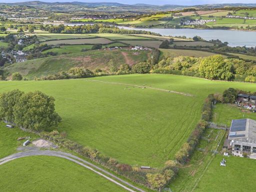 Land for sale in Stokeinteignhead, Newton Abbot, TQ12 — £140,000 • 1 bed • 1 bath • 2304 ft²
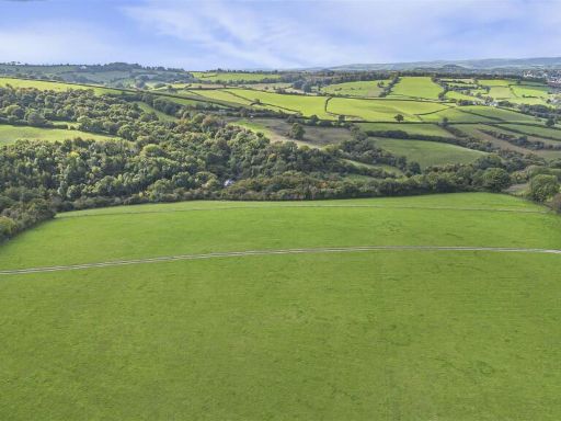 Land for sale in Stokeinteignhead, Newton Abbot, TQ12 — £90,000 • 1 bed • 1 bath • 2304 ft²
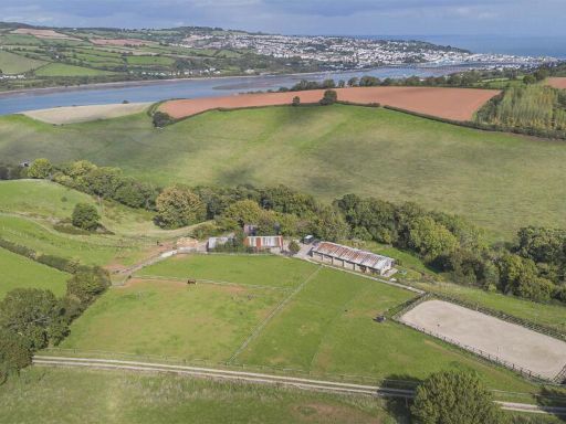 4 bedroom barn conversion for sale in Stokeinteignhead, Newton Abbot, TQ12 — £750,000 • 4 bed • 2 bath • 2061 ft²
Meta
- {
"@context": "https://schema.org",
"@type": "Residence",
"name": "Land for sale in Bishopsteignton, Teignmouth, TQ14",
"description": "",
"url": "https://propertypiper.co.uk/property/17254891-3c26-4a5e-8924-31a3eac4ed9d",
"image": "https://image-a.propertypiper.co.uk/bbf6c866-64d9-4f4a-80b5-e229932cd72e-1024.jpeg",
"address": {
"@type": "PostalAddress",
"streetAddress": "Bishopsteignton, Teignmouth",
"postalCode": "TQ14 9SA",
"addressLocality": "Teignbridge",
"addressRegion": "Newton Abbot",
"addressCountry": "England"
},
"geo": {
"@type": "GeoCoordinates",
"latitude": 50.553102579585016,
"longitude": -3.554648209346824
},
"numberOfRooms": 1,
"numberOfBathroomsTotal": 1,
"offers": {
"@type": "Offer",
"price": 125000,
"priceCurrency": "GBP",
"availability": "https://schema.org/InStock"
},
"additionalProperty": [
{
"@type": "PropertyValue",
"name": "Feature",
"value": "countryside"
},
{
"@type": "PropertyValue",
"name": "Feature",
"value": "landscape"
},
{
"@type": "PropertyValue",
"name": "Feature",
"value": "rural"
},
{
"@type": "PropertyValue",
"name": "Feature",
"value": "scenic"
},
{
"@type": "PropertyValue",
"name": "Feature",
"value": "fields"
},
{
"@type": "PropertyValue",
"name": "Feature",
"value": "hills"
},
{
"@type": "PropertyValue",
"name": "Feature",
"value": "nature"
},
{
"@type": "PropertyValue",
"name": "Feature",
"value": "pastoral"
},
{
"@type": "PropertyValue",
"name": "Feature",
"value": "stable"
},
{
"@type": "PropertyValue",
"name": "Feature",
"value": "wooden"
},
{
"@type": "PropertyValue",
"name": "Feature",
"value": "rustic"
},
{
"@type": "PropertyValue",
"name": "Feature",
"value": "outbuilding"
},
{
"@type": "PropertyValue",
"name": "Feature",
"value": "agricultural"
},
{
"@type": "PropertyValue",
"name": "Feature",
"value": "barn"
}
]
}
High Res Floorplan Images
Compatible Floorplan Images
FloorplanImages Thumbnail