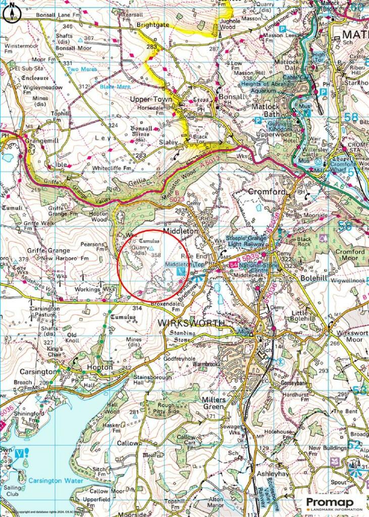
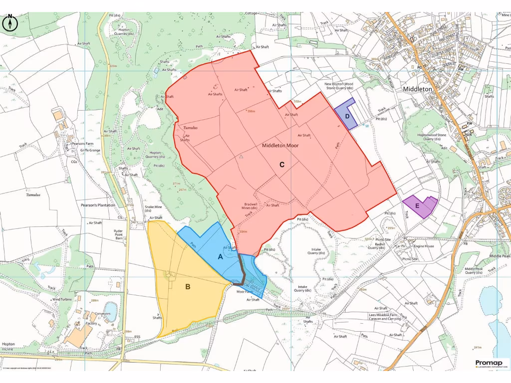
DE4 4HE - Land for sale in Lot C Land at Moor Farm, Middleton Moor, W…
View on Property Piper
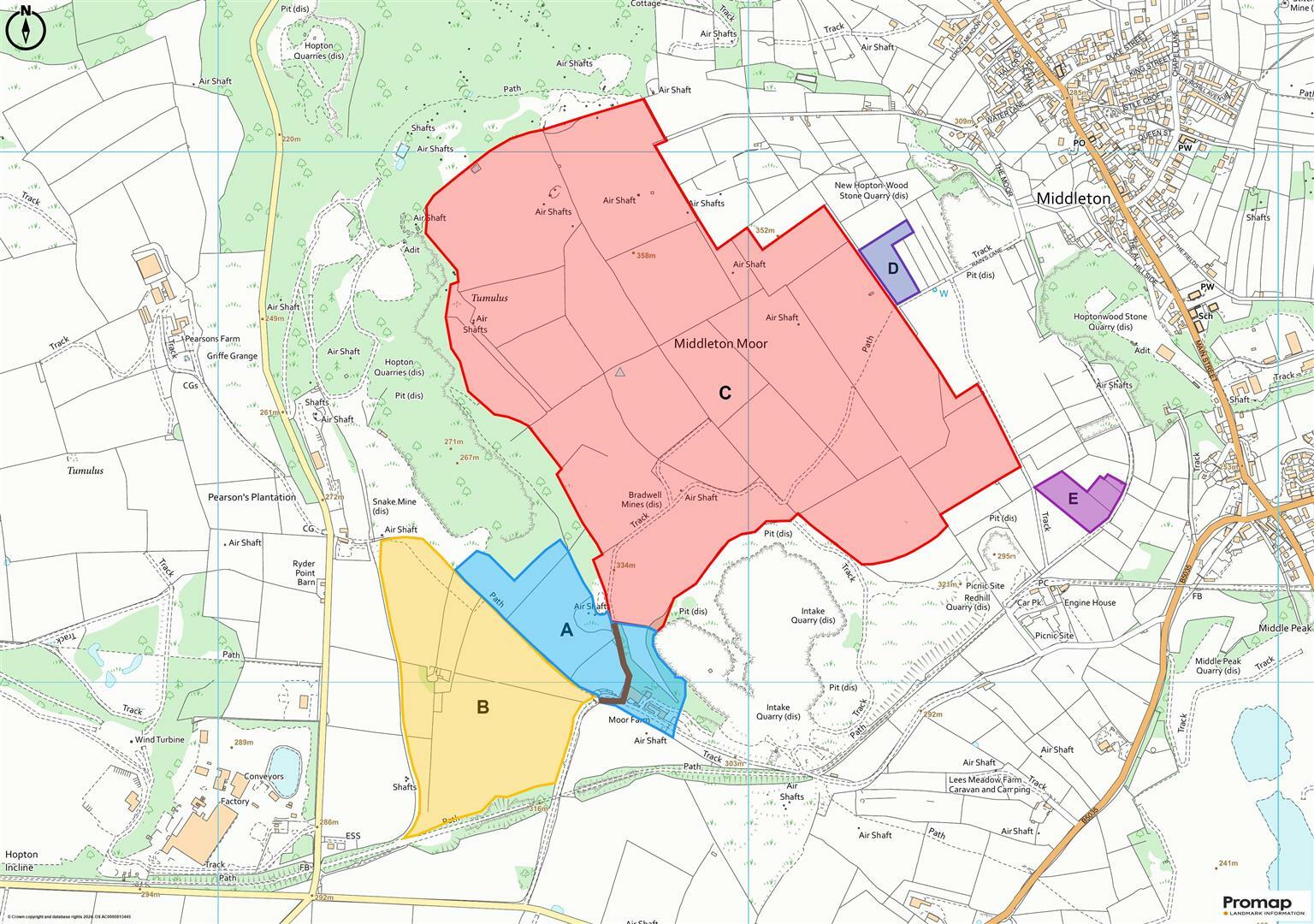
Land for sale in Lot C - Land at Moor Farm, Middleton Moor, Wirksworth, DE4
Property Details
- Price: £900000
- Bedrooms: 1
- Bathrooms: 1
- Property Type: undefined
- Property SubType: undefined
Brochure Descriptions
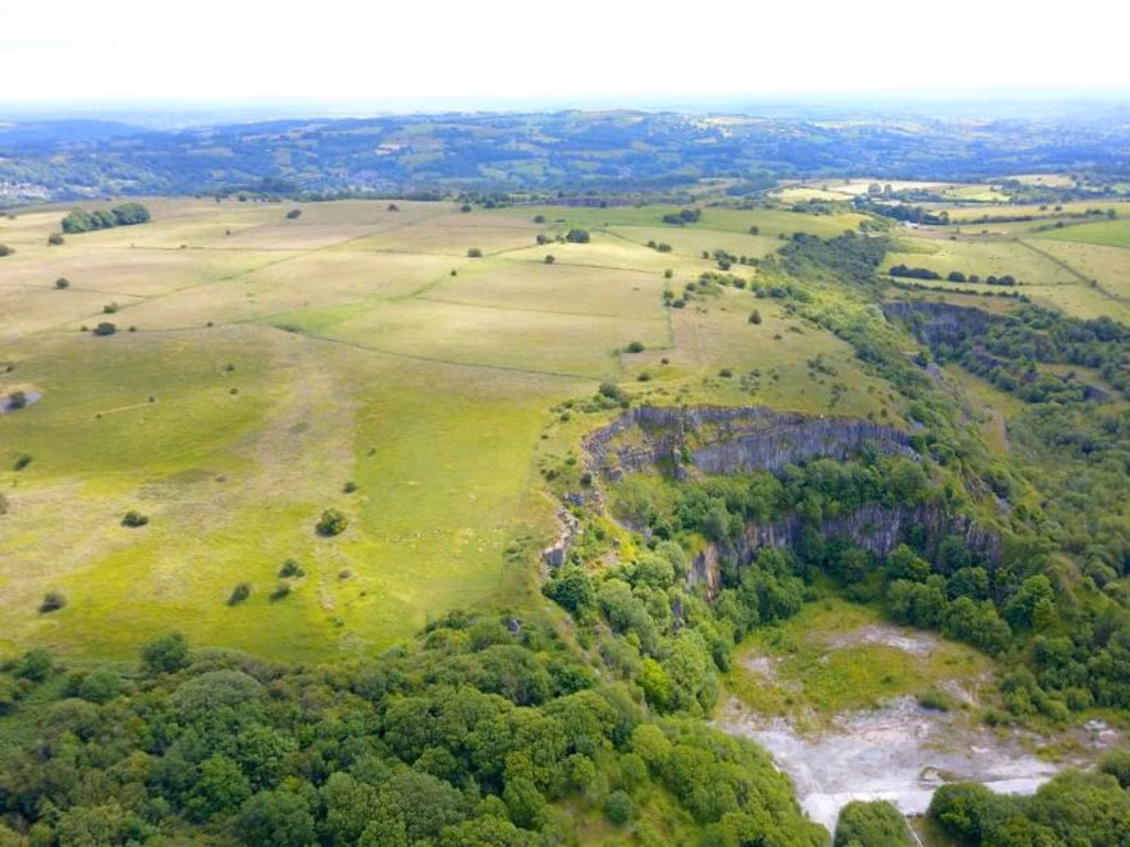
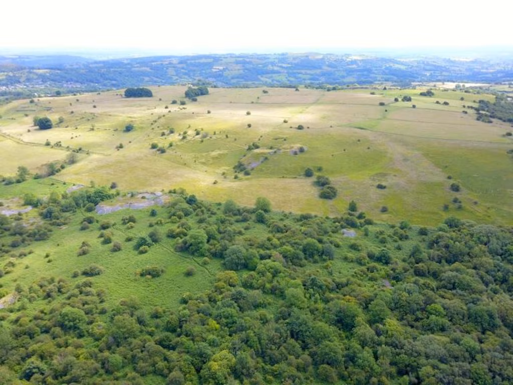
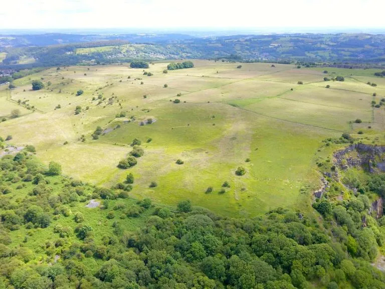
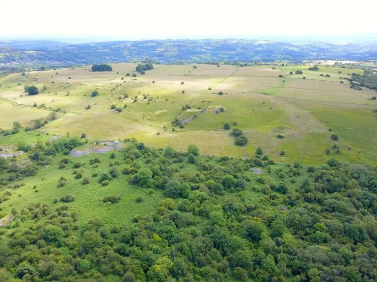
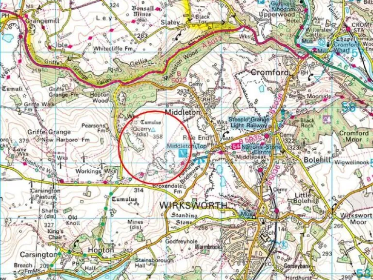
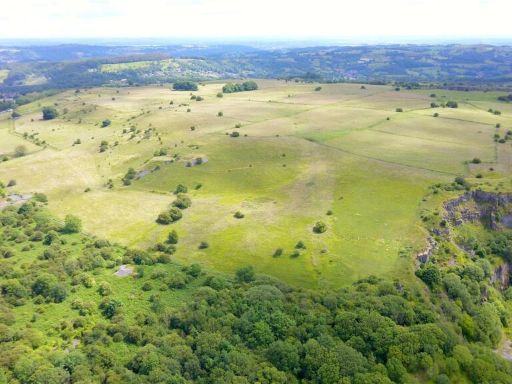
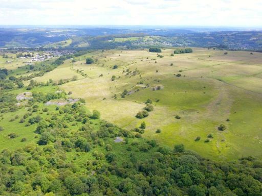
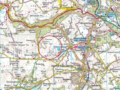
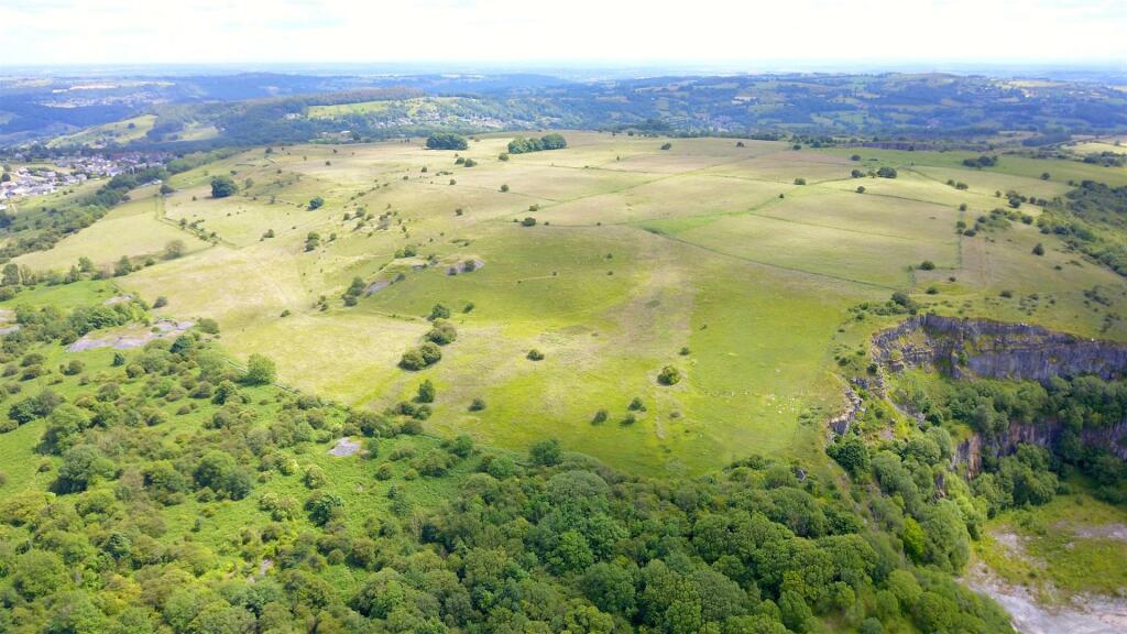
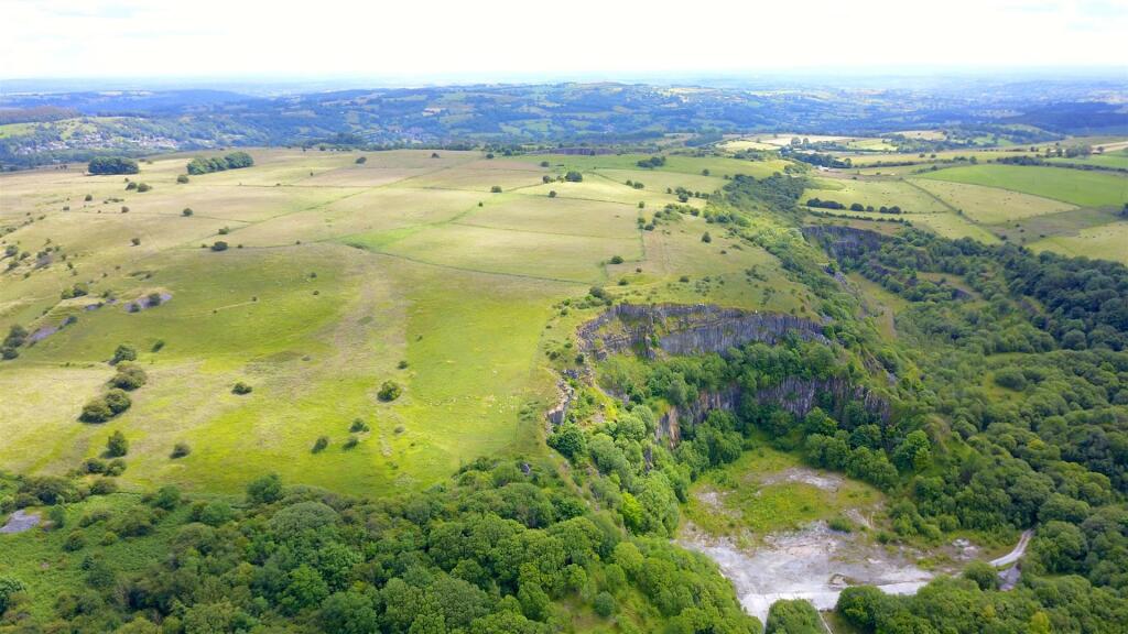
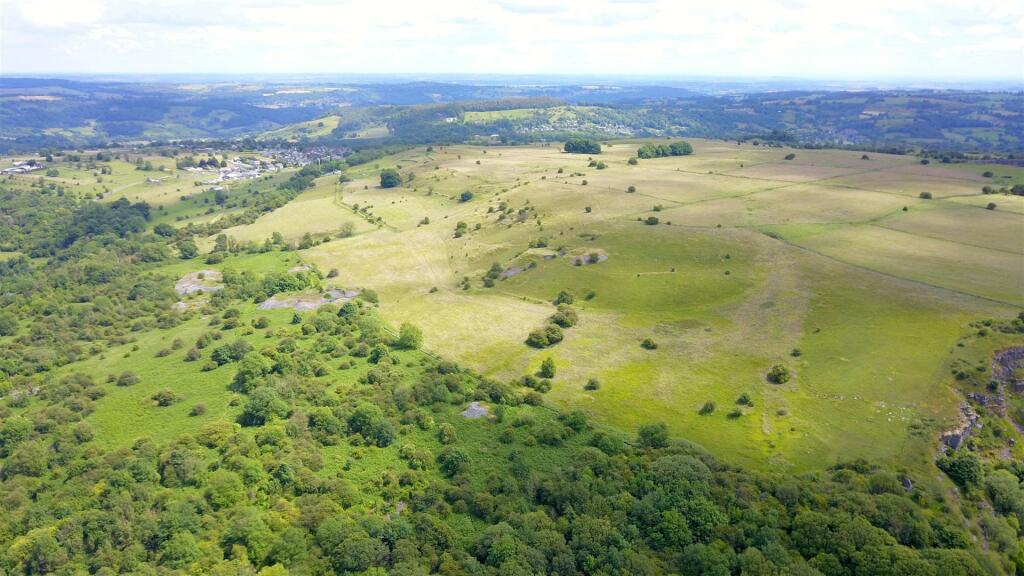
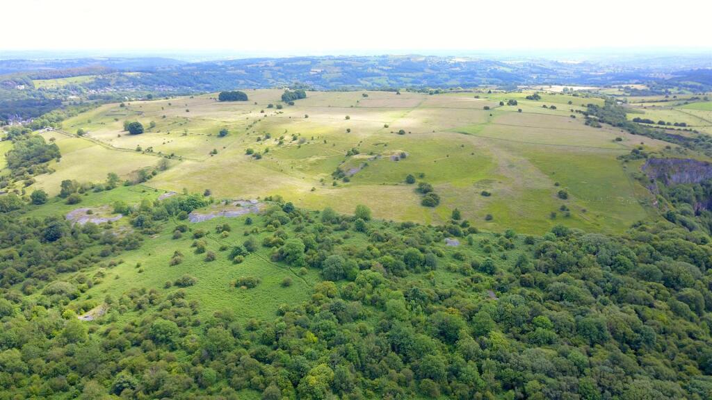
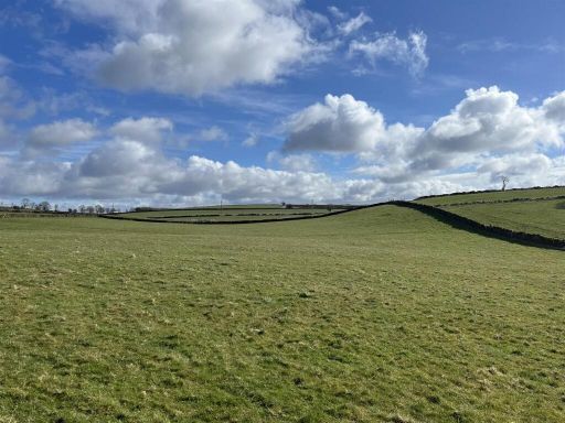
- The property for sale is a vast expanse of farmland located at Moor Farm, Middleton Moor. The landscape features extensive open fields, predominantly grass-covered, with gentle rolling hills that spread across the horizon. The property is bordered by lush green forested areas providing a serene and natural environment. There's an impressive view of undulating countryside with scattered tree groups and hedgerows. The land appears to be of large size, suitable for agriculture or potential development, offering panoramic views of the surrounding rural idyll, likely appealing to those seeking expansive outdoor space and privacy.
- The property offers an impressively expansive block of land, extending over 148.23 acres, in a serene Derbyshire countryside setting. The landscape is characterized by rolling green fields, ideal for grazing or agriculture, and showcases a scenic view with the occasional gentle slopes, which might accentuate the tranquil rural panorama. The property size is extensive, catering primarily to agricultural, equestrian, or smallholder pursuits, with potential for development subject to planning consents. Existing patches of mature trees scatter across the land, adding character to the otherwise open expanse. Overall, it's a substantial rural property that would appeal to those looking for extensive land in a picturesque setting.
Textual Property Features
Detected Visual Features
- rural
- land
- expansive
- rolling fields
- open space
- agriculture
- countryside
- undeveloped
- greenery
- natural
- investment
- pasture
- quarry
- trees
- rocks
Nearby Schools
- Kniveton CofE Primary School
- Wirksworth Junior School
- Wirksworth CofE Infant School
- Cromford Church of England Primary School
- Tansley Primary School
- St Joseph's Catholic Voluntary Academy
- South Darley CofE Primary School
- Anthony Gell School
- Crich Carr CofE Primary School
- Brassington Primary School
- Lea Primary School
- Matlock Bath Holy Trinity CofE Controlled Primary School
- St Giles Church of England Primary School
- All Saints CofE Infant School
- Elton CofE Primary School
- All Saints CofE Junior School
- Highfields School
- Carsington and Hopton Primary School
- Middleton Community Primary School
- Bonsall CofE (A) Primary School
- Castle View Primary School
- Kirk Ireton C of E Primary School
- Winster CofE Primary School
- Darley Dale Primary School
Nearest General Shops
- Id: 9471551539
- Tags:
- Contact:
- Facebook: Wild1Wirksworth
- Male: yes
- Name: Wild 1
- Shop: hairdresser
- TagsNormalized:
- Lat: 53.0820096
- Lon: -1.5747697
- FullGeoHash: gcqvupm315y9
- PartitionGeoHash: gcqv
- Images:
- FoodStandards: null
- Distance: 2670.5
,- Id: 285715587
- Tags:
- Building: yes
- Name: Almark Garage
- Opening_hours: Mo-Fr 08:00-17:00
- Phone: +44 1629 823319
- Shop: car_repair
- TagsNormalized:
- garage
- car repair
- repair
- shop
- Lat: 53.0829251
- Lon: -1.575972
- FullGeoHash: gcqvupkqmnqn
- PartitionGeoHash: gcqv
- Images:
- FoodStandards: null
- Distance: 2562.4
,- Id: 6704654722
- Tags:
- Amenity: bicycle_rental
- Bicycle:
- Shop: rental
- TagsNormalized:
- bicycle
- bicycle rental
- shop
- Lat: 53.0930909
- Lon: -1.590245
- FullGeoHash: gcqy5c618t7r
- PartitionGeoHash: gcqy
- Images:
- FoodStandards: null
- Distance: 1534.9
}
Nearest Religious buildings
- Id: 160531758
- Tags:
- Addr:
- City: Wirksworth
- Postcode: DE4 4DP
- Street: St. Mary's Gate
- Amenity: place_of_worship
- Building: church
- Denomination: anglican
- Name: St Mary's Church
- Religion: christian
- Wikidata: Q7594459
- Wikipedia: en:St Mary's Church, Wirksworth
- TagsNormalized:
- place of worship
- church
- anglican
- christian
- Lat: 53.0819475
- Lon: -1.5722685
- FullGeoHash: gcqvupr0g2pw
- PartitionGeoHash: gcqv
- Images:
- FoodStandards: null
- Distance: 2831.1
,- Id: 291322589
- Tags:
- Addr:
- City: Wirksworth
- Postcode: DE4 4NR
- Street: Coldwell Street
- Amenity: place_of_worship
- Building: church
- Denomination: united_reformed
- Name: West Derbyshire United Reformed Church
- Religion: christian
- TagsNormalized:
- place of worship
- church
- united reformed
- christian
- Lat: 53.0830352
- Lon: -1.5727271
- FullGeoHash: gcqvupqz0fcx
- PartitionGeoHash: gcqv
- Images:
- FoodStandards: null
- Distance: 2766.5
,- Id: 240570757
- Tags:
- Addr:
- Postcode: DE4 4LQ
- Street: Main Street
- Amenity: place_of_worship
- Denomination: anglican
- Name: Holy Trinity
- Religion: christian
- Wikidata: Q26405690
- TagsNormalized:
- place of worship
- anglican
- christian
- church
- Lat: 53.0980553
- Lon: -1.5856604
- FullGeoHash: gcqy5fjqe6vv
- PartitionGeoHash: gcqy
- Images:
- FoodStandards: null
- Distance: 2016.9
}
Nearest Medical buildings
- Id: 939591682
- Tags:
- Amenity: dentist
- Healthcare: dentist
- Name: Dale Road Dental Practice
- Source: survey
- TagsNormalized:
- dentist
- health
- healthcare
- dental
- Lat: 53.1359654
- Lon: -1.5559086
- FullGeoHash: gcqyk9552tyk
- PartitionGeoHash: gcqy
- Images:
- FoodStandards: null
- Distance: 6373.9
,- Id: 233844988
- Tags:
- Amenity: doctors
- Building: health_centre
- Healthcare: doctor
- Name: Hannage Brook Medical Centre
- Website: https://hannagebrook.co.uk/
- Wheelchair: yes
- TagsNormalized:
- doctor
- doctors
- health
- health centre
- healthcare
- Lat: 53.0776223
- Lon: -1.5713512
- FullGeoHash: gcqvunrz8cgt
- PartitionGeoHash: gcqv
- Images:
- FoodStandards: null
- Distance: 3069.8
,- Id: 292556052
- Tags:
- Addr:
- Amenity: dentist
- Building: yes
- Contact:
- Website: https://www.bupa.co.uk/dental/dental-care/practices/platinum-steeple-grange-dental-care
- Healthcare: dentist
- Name: Steeple Grange Dental Practice
- Operator: Bupa
- Operator:wikidata: Q931628
- TagsNormalized:
- dentist
- health
- healthcare
- dental
- Lat: 53.094863
- Lon: -1.5685928
- FullGeoHash: gcqyh39gcpu6
- PartitionGeoHash: gcqy
- Images:
- FoodStandards: null
- Distance: 2990.1
,- Id: 289021533
- Tags:
- Amenity: dentist
- Building: yes
- Healthcare: dentist
- Name: Coach House Dental Practice
- Website: https://www.thecoachhousedental.co.uk/
- TagsNormalized:
- dentist
- health
- healthcare
- dental
- Lat: 53.0820822
- Lon: -1.5700665
- FullGeoHash: gcqvur29wc3d
- PartitionGeoHash: gcqv
- Images:
- FoodStandards: null
- Distance: 2966.9
}
Nearest Leisure Facilities
- Id: 8759772076
- Tags:
- TagsNormalized:
- picnic
- picnic table
- leisure
- Lat: 53.0925148
- Lon: -1.5894435
- FullGeoHash: gcqy5c4w7615
- PartitionGeoHash: gcqy
- Images:
- FoodStandards: null
- Distance: 1573.5
,- Id: 4018507479
- Tags:
- TagsNormalized:
- picnic
- picnic table
- leisure
- Lat: 53.0932855
- Lon: -1.5905241
- FullGeoHash: gcqy5c3ff1g2
- PartitionGeoHash: gcqy
- Images:
- FoodStandards: null
- Distance: 1522.1
,- Id: 8759772077
- Tags:
- TagsNormalized:
- picnic
- picnic table
- leisure
- Lat: 53.0923554
- Lon: -1.590263
- FullGeoHash: gcqy5c4j2hmu
- PartitionGeoHash: gcqy
- Images:
- FoodStandards: null
- Distance: 1516.5
,- Id: 8759772078
- Tags:
- TagsNormalized:
- picnic
- picnic table
- leisure
- Lat: 53.0924085
- Lon: -1.590322
- FullGeoHash: gcqy5c1vwy3c
- PartitionGeoHash: gcqy
- Images:
- FoodStandards: null
- Distance: 1513.7
,- Id: 4018507466
- Tags:
- TagsNormalized:
- picnic
- picnic table
- leisure
- Lat: 53.0932074
- Lon: -1.5906352
- FullGeoHash: gcqy5c3dre0q
- PartitionGeoHash: gcqy
- Images:
- FoodStandards: null
- Distance: 1512.7
}
Nearest Tourist attractions
- Id: 172178765
- Tags:
- TagsNormalized:
- Lat: 53.0929969
- Lon: -1.5898885
- FullGeoHash: gcqy5c630gvn
- PartitionGeoHash: gcqy
- Images:
- FoodStandards: null
- Distance: 1555.6
,- Id: 8931155467
- Tags:
- Caravans: yes
- Tourism: camp_site
- TagsNormalized:
- Lat: 53.095551
- Lon: -1.632202
- FullGeoHash: gcqy4cg2nbjf
- PartitionGeoHash: gcqy
- Images:
- FoodStandards: null
- Distance: 1456.8
,- Id: 7609596154
- Tags:
- Caravans: yes
- Name: Peak View Caravan Site
- Tourism: camp_site
- TagsNormalized:
- Lat: 53.0847515
- Lon: -1.5943604
- FullGeoHash: gcqvgxz10dyt
- PartitionGeoHash: gcqv
- Images:
- FoodStandards: null
- Distance: 1341.2
}
Nearest Train stations
- Id: 6415346592
- Tags:
- Name: Cromford
- Naptan:
- Network: National Rail
- Public_transport: station
- Railway: station
- Ref:
- Source: NPE
- Wikidata: Q2079568
- Wikipedia: en:Cromford railway station
- TagsNormalized:
- Lat: 53.1129115
- Lon: -1.5490661
- FullGeoHash: gcqyhubj0hkd
- PartitionGeoHash: gcqy
- Images:
- FoodStandards: null
- Distance: 4956.6
,- Id: 251735751
- Tags:
- Name: Wirksworth
- Naptan:
- Public_transport: station
- Railway: station
- Usage: tourism
- Wikidata: Q8026960
- Wikipedia: en:Wirksworth railway station
- TagsNormalized:
- Lat: 53.0827559
- Lon: -1.5687991
- FullGeoHash: gcqvur3tkqft
- PartitionGeoHash: gcqv
- Images:
- FoodStandards: null
- Distance: 3027.7
,- Id: 1617706532
- Tags:
- Name: Steeple Grange
- Public_transport: station
- Railway: station
- Usage: tourism
- TagsNormalized:
- Lat: 53.0957021
- Lon: -1.5707431
- FullGeoHash: gcqyh3b0zh30
- PartitionGeoHash: gcqy
- Images:
- FoodStandards: null
- Distance: 2868.9
,- Id: 2398089855
- Tags:
- Name: Ravenstor
- Public_transport: station
- Railway: station
- Usage: tourism
- Wikidata: Q7296554
- Wikipedia: en:Ravenstor railway station
- TagsNormalized:
- Lat: 53.0901924
- Lon: -1.57288
- FullGeoHash: gcqyh0y8v1pt
- PartitionGeoHash: gcqy
- Images:
- FoodStandards: null
- Distance: 2651.3
,- Id: 1617706519
- Tags:
- Fixme: location needs verification as the trees are too dense to see the platfom...
- Name: Recreation Ground Halt
- Public_transport: station
- Railway: station
- Request_stop: yes
- Usage: tourism
- TagsNormalized:
- Lat: 53.0964641
- Lon: -1.574777
- FullGeoHash: gcqyh1vm3431
- PartitionGeoHash: gcqy
- Images:
- FoodStandards: null
- Distance: 2629.8
}
Nearest Bus stations and stops
- Id: 7784990836
- Tags:
- Bench: no
- Bin: no
- Bus: yes
- Highway: bus_stop
- Name: Rising Sun
- Public_transport: platform
- Shelter: no
- Tactile_paving: no
- TagsNormalized:
- Lat: 53.0956717
- Lon: -1.5844989
- FullGeoHash: gcqy5cy0wqxf
- PartitionGeoHash: gcqy
- Images:
- FoodStandards: null
- Distance: 1984.4
,- Id: 7784990841
- Tags:
- Bus: yes
- Highway: bus_stop
- Name: Church
- Public_transport: platform
- TagsNormalized:
- Lat: 53.0981432
- Lon: -1.5863218
- FullGeoHash: gcqy5fhzh529
- PartitionGeoHash: gcqy
- Images:
- FoodStandards: null
- Distance: 1982.2
,- Id: 7784990839
- Tags:
- Bus: yes
- Highway: bus_stop
- Name: The Green
- Public_transport: platform
- TagsNormalized:
- Lat: 53.0994756
- Lon: -1.5876186
- FullGeoHash: gcqy5f7yvg9v
- PartitionGeoHash: gcqy
- Images:
- FoodStandards: null
- Distance: 1982.1
,- Id: 7784990837
- Tags:
- Bus: yes
- Highway: bus_stop
- Name: Rising Sun
- Public_transport: platform
- TagsNormalized:
- Lat: 53.095321
- Lon: -1.5844654
- FullGeoHash: gcqy5cwnxm0y
- PartitionGeoHash: gcqy
- Images:
- FoodStandards: null
- Distance: 1974.2
,- Id: 8759772073
- Tags:
- Bench: no
- Bin: no
- Bus: yes
- Highway: bus_stop
- Passenger_information_display: no
- Public_transport: platform
- Shelter: no
- TagsNormalized:
- Lat: 53.092841
- Lon: -1.5863672
- FullGeoHash: gcqy5ckb4yyu
- PartitionGeoHash: gcqy
- Images:
- FoodStandards: null
- Distance: 1782.1
}
Nearest Hotels
- Id: 229681483
- Tags:
- Addr:
- City: Matlock
- Housenumber: 170
- Postcode: DE4 3PS
- Street: Dale Road
- Building: yes
- Fhrs:
- Name: High Tor Hotel
- Note: (former location of William,s Bar!)
- Tourism: hotel
- Wikidata: Q26554647
- TagsNormalized:
- Lat: 53.1297591
- Lon: -1.5603629
- FullGeoHash: gcqyhrzz2bvn
- PartitionGeoHash: gcqy
- Images:
- FoodStandards: null
- Distance: 5644.7
,- Id: 80581307
- Tags:
- Addr:
- City: Matlock
- Postcode: DE4 3PX
- Street: New Bath Road
- Village: Matlock Bath
- Building: yes
- Fhrs:
- Name: New Bath Hotel
- Source: OS_OpenData_StreetView;survey
- Tourism: hotel
- Website: https://newbathhotelandspa.com/
- Wikidata: Q26676991
- TagsNormalized:
- Lat: 53.1154821
- Lon: -1.5613169
- FullGeoHash: gcqyhmrh4et8
- PartitionGeoHash: gcqy
- Images:
- FoodStandards: null
- Distance: 4455.3
,- Id: 2626347310
- Tags:
- Name: Alison House
- Tourism: hotel
- TagsNormalized:
- Lat: 53.1068245
- Lon: -1.558502
- FullGeoHash: gcqyhec1sm8e
- PartitionGeoHash: gcqy
- Images:
- FoodStandards: null
- Distance: 4075.3
}
Tags
- rural
- land
- expansive
- rolling fields
- open space
- agriculture
- countryside
- undeveloped
- greenery
- natural
- investment
- land
- countryside
- pasture
- quarry
- trees
- rocks
- undeveloped
- rural
Local Market Stats
- Average Price/sqft: £284
- Avg Income: £41800
- Rental Yield: 3.3%
- Social Housing: 6%
- Planning Success Rate: 68%
Similar Properties
 Land for sale in Lot A Land off Moor Lane, Elton Moor, Matlock, DE4 — £70,000 • 1 bed • 1 bath
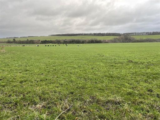 Land for sale in Bakewell, Bakewell, DE45 — £282,000 • 1 bed • 1 bath
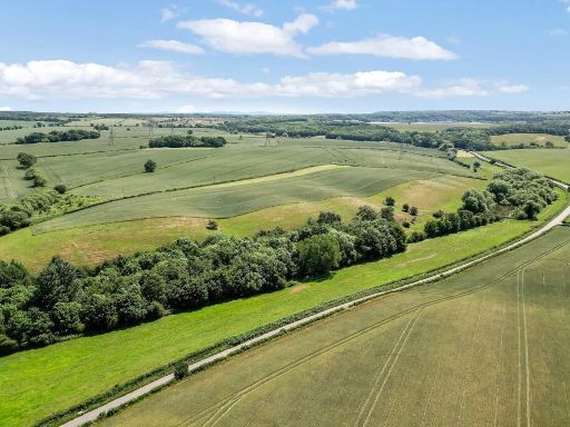 Land for sale in Derby, Derbyshire, DE65 — £3,400,000 • 1 bed • 1 bath
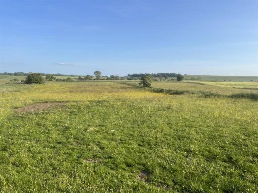 Land for sale in Lot A, Land at Elton Moor, Elton, Matlock, DE4 — £25,000 • 1 bed • 1 bath
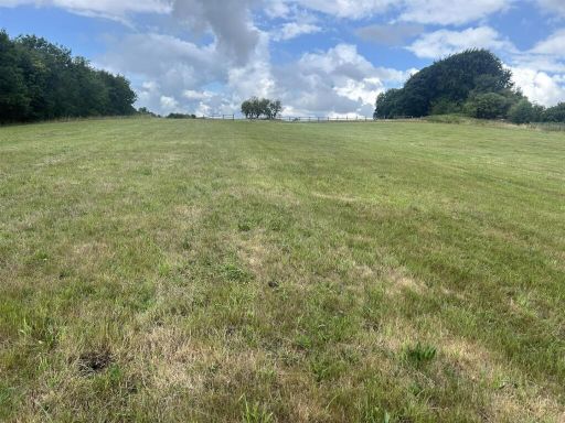 Land for sale in Land at Tearsall Farm, Bonsall Lane, Bonsall, Matlock, DE4 — £75,000 • 1 bed • 1 bath
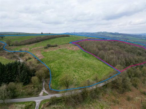 Land for sale in Lot 2: Gospel Farm, Bramley Lane, Hassop, Bakewell, DE45 — £300,000 • 1 bed • 1 bath
Meta
- {
"@context": "https://schema.org",
"@type": "Residence",
"name": "Land for sale in Lot C Land at Moor Farm, Middleton Moor, W…",
"description": "",
"url": "https://propertypiper.co.uk/property/f8bbab83-7c73-4260-b0d1-96d51e9fcf36",
"image": "https://image-a.propertypiper.co.uk/96c739c3-ee00-4902-8b69-c700bc2fadd8-1024.jpeg",
"address": {
"@type": "PostalAddress",
"streetAddress": "Lot C - Land at Moor Farm, Middleton Moor, Wirksworth",
"postalCode": "DE4 4HE",
"addressLocality": "Derbyshire Dales",
"addressRegion": "Derbyshire Dales",
"addressCountry": "England"
},
"geo": {
"@type": "GeoCoordinates",
"latitude": 53.08982696443777,
"longitude": -1.6125784137537753
},
"numberOfRooms": 1,
"numberOfBathroomsTotal": 1,
"offers": {
"@type": "Offer",
"price": 900000,
"priceCurrency": "GBP",
"availability": "https://schema.org/InStock"
},
"additionalProperty": [
{
"@type": "PropertyValue",
"name": "Feature",
"value": "rural"
},
{
"@type": "PropertyValue",
"name": "Feature",
"value": "land"
},
{
"@type": "PropertyValue",
"name": "Feature",
"value": "expansive"
},
{
"@type": "PropertyValue",
"name": "Feature",
"value": "rolling fields"
},
{
"@type": "PropertyValue",
"name": "Feature",
"value": "open space"
},
{
"@type": "PropertyValue",
"name": "Feature",
"value": "agriculture"
},
{
"@type": "PropertyValue",
"name": "Feature",
"value": "countryside"
},
{
"@type": "PropertyValue",
"name": "Feature",
"value": "undeveloped"
},
{
"@type": "PropertyValue",
"name": "Feature",
"value": "greenery"
},
{
"@type": "PropertyValue",
"name": "Feature",
"value": "natural"
},
{
"@type": "PropertyValue",
"name": "Feature",
"value": "investment"
},
{
"@type": "PropertyValue",
"name": "Feature",
"value": "land"
},
{
"@type": "PropertyValue",
"name": "Feature",
"value": "countryside"
},
{
"@type": "PropertyValue",
"name": "Feature",
"value": "pasture"
},
{
"@type": "PropertyValue",
"name": "Feature",
"value": "quarry"
},
{
"@type": "PropertyValue",
"name": "Feature",
"value": "trees"
},
{
"@type": "PropertyValue",
"name": "Feature",
"value": "rocks"
},
{
"@type": "PropertyValue",
"name": "Feature",
"value": "undeveloped"
},
{
"@type": "PropertyValue",
"name": "Feature",
"value": "rural"
}
]
}
High Res Floorplan Images
Compatible Floorplan Images
FloorplanImages Thumbnail