DE45 1NT - Land for sale in Lot 2: Gospel Farm, Bramley Lane, Hassop,…
View on Property Piper
Land for sale in Lot 2: Gospel Farm, Bramley Lane, Hassop, Bakewell, DE45
Property Details
- Price: £300000
- Bedrooms: 1
- Bathrooms: 1
- Property Type: undefined
- Property SubType: undefined
Brochure Descriptions
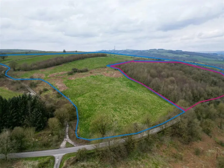
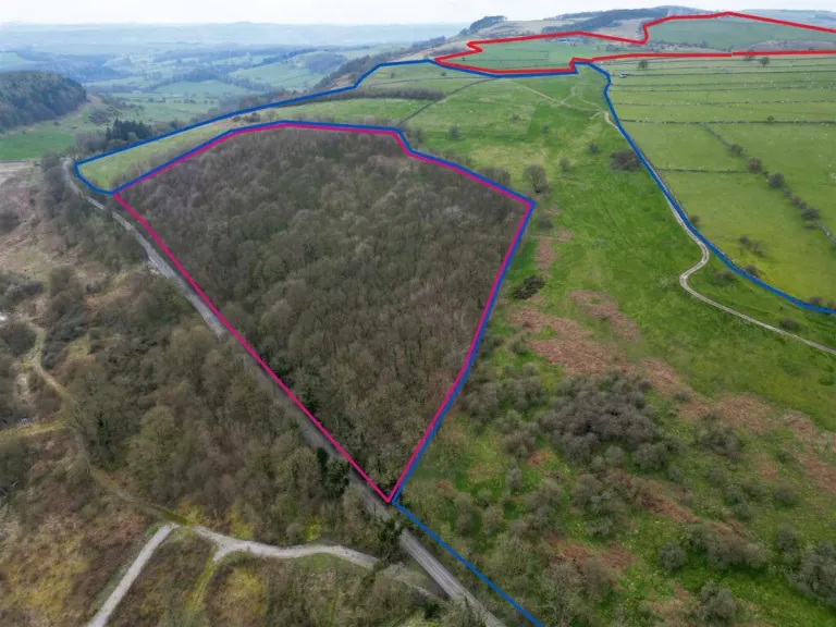
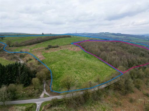
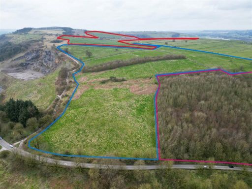
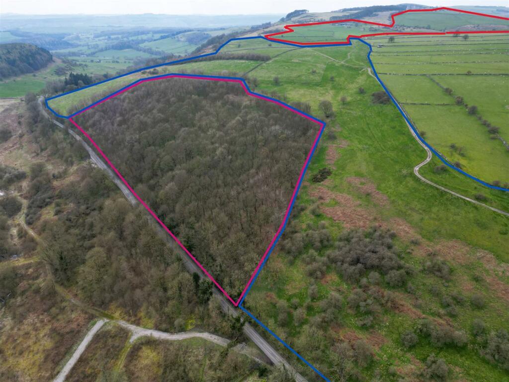
- Gospel Farm is a sprawling property set amidst rolling hills and expansive greenery, offering spectacular panoramic views of the surrounding countryside. The land appears extensive, suitable for various agricultural pursuits, and encompasses vast fields with clear boundaries. The property size is large, catering to those interested in extensive outdoor space or farming opportunities. The sheer expanse and natural beauty of the estate provide a serene and picturesque retreat.
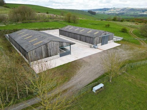
- This property features a large agricultural shed that is well-suited for farming or storage purposes. The structure is robust, constructed with wooden and stone materials, providing durability and maintaining an aesthetic that blends with its rural surroundings. The property offers expansive outdoor space with a wide, concrete yard area, which enhances the functionality for agricultural operations or parking. The shed's design suggests spacious interiors suitable for housing equipment or livestock. This rural property is set against a scenic backdrop of rolling countryside, offering exceptional pastoral views. The property's overall size is generous, making it ideal for extensive agricultural use.
Image Descriptions
- land plot rural
- agricultural land
Floorplan Description
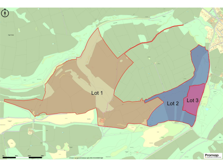
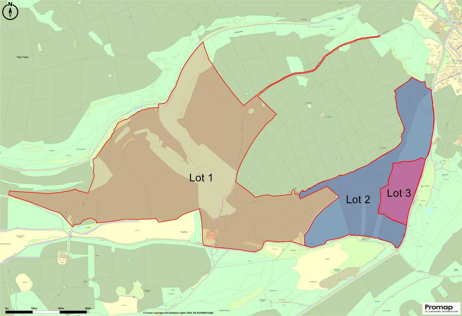
- Map showing property lots categorized as Lot 1, Lot 2, and Lot 3.
Textual Property Features
Detected Visual Features
- land
- plot
- rural
- agricultural
- development potential
- green space
- countryside
- agricultural land
- farmland
- pasture
- undeveloped land
- open fields
- potential development
- acreage
- investment land
- nature
- landscape
- expansion
- privacy
Nearby Schools
- Great Hucklow CE Primary
- Rowsley CofE (Controlled) Primary School
- Bakewell CofE Infant School
- St Anselm's School
- St Anne's CofE Primary School
- Curbar Primary School
- Eyam CofE Primary School
- Bradwell CofE (Controlled) Infant School
- Litton CofE Primary School
- Lady Manners School
- Pilsley CofE Primary School
- Longstone CofE Primary School
- Stoney Middleton CofE (C) Primary School
- Grindleford Primary School
- Bradwell Junior School
Nearest General Shops
- Id: 256168498
- Tags:
- Building: yes
- Name: Peaklander Factory Shop
- Shop: clothes
- TagsNormalized:
- Lat: 53.2698045
- Lon: -1.6437477
- FullGeoHash: gcqz497p1gkc
- PartitionGeoHash: gcqz
- Images:
- FoodStandards: null
- Distance: 2287.3
,- Id: 256168494
- Tags:
- Name: Calver Garden Centre
- Shop: garden_centre
- TagsNormalized:
- Lat: 53.2693728
- Lon: -1.6441107
- FullGeoHash: gcqz496u96y4
- PartitionGeoHash: gcqz
- Images:
- FoodStandards: null
- Distance: 2234.2
,- Id: 203137233
- Tags:
- Addr:
- City: Bakewell
- Postcode: DE45 1UF
- Street: Top Road
- Village: Pilsley
- Building: retail
- Fhrs:
- Name: Chatsworth Farm Shop
- Shop: farm
- Source: Survey, Bing
- TagsNormalized:
- Lat: 53.2341304
- Lon: -1.6383342
- FullGeoHash: gcqyfdzp211m
- PartitionGeoHash: gcqy
- Images:
- FoodStandards:
- Id: 810470
- FHRSID: 810470
- LocalAuthorityBusinessID: PI/000019237
- BusinessName: Chatsworth Farm Shop
- BusinessType: Retailers - other
- BusinessTypeID: 4613
- AddressLine1: Chatsworth Stud Farm
- AddressLine2: Top Road
- AddressLine3: Pilsley
- AddressLine4: Derbyshire
- PostCode: DE45 1UF
- RatingValue: 5
- RatingKey: fhrs_5_en-GB
- RatingDate: 2022-02-07
- LocalAuthorityCode: 070
- LocalAuthorityName: Derbyshire Dales
- LocalAuthorityWebSite: http://www.derbyshiredales.gov.uk/fhrs
- LocalAuthorityEmailAddress: envhealth@derbyshiredales.gov.uk
- Scores:
- Hygiene: 5
- Structural: 5
- ConfidenceInManagement: 5
- NewRatingPending: false
- Geocode:
- Longitude: -1.64054500000000
- Latitude: 53.23486100000000
- Distance: 2080.7
}
Nearest Religious buildings
- Id: 463345462
- Tags:
- Amenity: place_of_worship
- Building: church
- Denomination: anglican
- Name: St Anne's Church
- Religion: christian
- Website: https://www.stannesbaslow.org.uk/
- Wikidata: Q7586994
- Wikipedia: en:St Anne's Church, Baslow
- TagsNormalized:
- place of worship
- church
- anglican
- christian
- Lat: 53.2473779
- Lon: -1.62404
- FullGeoHash: gcqygj3kmnsj
- PartitionGeoHash: gcqy
- Images:
- FoodStandards: null
- Distance: 2037.1
,- Id: 10962845
- Tags:
- Name: Baslow (Church)
- Public_transport: stop_area
- Type: public_transport
- TagsNormalized:
- Lat: 53.2478761
- Lon: -1.6242131
- FullGeoHash: gcqygj3r35dc
- PartitionGeoHash: gcqy
- Images:
- FoodStandards: null
- Distance: 2017.8
,- Id: 84327072
- Tags:
- Amenity: place_of_worship
- Building: yes
- Denomination: catholic
- Religion: christian
- Source: visual survey;OS_OpenData_StreetView
- TagsNormalized:
- place of worship
- catholic
- christian
- church
- Lat: 53.2474443
- Lon: -1.6665785
- FullGeoHash: gcqyfj6kvgj1
- PartitionGeoHash: gcqy
- Images:
- FoodStandards: null
- Distance: 874.3
}
Nearest Leisure Facilities
- Id: 337781498
- Tags:
- TagsNormalized:
- Lat: 53.2554471
- Lon: -1.6242209
- FullGeoHash: gcqygnc72yvh
- PartitionGeoHash: gcqy
- Images:
- FoodStandards: null
- Distance: 2082.8
,- Id: 337805405
- Tags:
- Leisure: pitch
- Sport: soccer
- TagsNormalized:
- Lat: 53.260301
- Lon: -1.6280382
- FullGeoHash: gcqyfzwrxzww
- PartitionGeoHash: gcqy
- Images:
- FoodStandards: null
- Distance: 2074.7
,- Id: 1021390555
- Tags:
- Leisure: pitch
- Sport: tennis
- TagsNormalized:
- Lat: 53.2501975
- Lon: -1.6296439
- FullGeoHash: gcqyfvvkfs33
- PartitionGeoHash: gcqy
- Images:
- FoodStandards: null
- Distance: 1639.5
,- Id: 1021454478
- Tags:
- Leisure: pitch
- Sport: equestrian
- TagsNormalized:
- pitch
- leisure
- equestrian
- sports
- Lat: 53.2477991
- Lon: -1.6705922
- FullGeoHash: gcqycvrwbmhn
- PartitionGeoHash: gcqy
- Images:
- FoodStandards: null
- Distance: 1117.9
,- Id: 628262729
- Tags:
- Access: customers
- Leisure: garden
- Source: EsriWorldImageryClarity
- TagsNormalized:
- Lat: 53.2466606
- Lon: -1.6679069
- FullGeoHash: gcqyfj32qbyq
- PartitionGeoHash: gcqy
- Images:
- FoodStandards: null
- Distance: 989
}
Nearest Tourist attractions
- Id: 9842331034
- Tags:
- Name: Calver Mill Gallery
- Tourism: gallery
- TagsNormalized:
- Lat: 53.2669097
- Lon: -1.6321297
- FullGeoHash: gcqz4bgw0xev
- PartitionGeoHash: gcqz
- Images:
- FoodStandards: null
- Distance: 2369.5
,- Id: 1375541883
- Tags:
- Amenity: cafe
- Name: No 19 at Whites
- Tourism: attraction
- TagsNormalized:
- Lat: 53.2697342
- Lon: -1.6424821
- FullGeoHash: gcqz497yxqhw
- PartitionGeoHash: gcqz
- Images:
- FoodStandards: null
- Distance: 2307.1
,- Id: 337804123
- Tags:
- Name: Broughton Caravan Park
- Tourism: caravan_site
- TagsNormalized:
- Lat: 53.2643661
- Lon: -1.6323791
- FullGeoHash: gcqz4b7r6v9b
- PartitionGeoHash: gcqz
- Images:
- FoodStandards: null
- Distance: 2143.9
}
Nearest Train stations
- Id: 370186628
- Tags:
- Name: Dronfield
- Naptan:
- Network: National Rail
- Platforms: 2
- Public_transport: station
- Railway: station
- Ref:
- Wikidata: Q2161199
- Wikipedia: en:Dronfield railway station
- TagsNormalized:
- Lat: 53.3014
- Lon: -1.4692529
- FullGeoHash: gcqznx4p5vje
- PartitionGeoHash: gcqz
- Images:
- FoodStandards: null
- Distance: 13555.3
,- Id: 5177806338
- Tags:
- Name: Matlock Riverside
- Public_transport: station
- Railway: station
- Usage: tourism
- Wikidata: Q6787688
- Wikipedia: en:Matlock Riverside railway station
- TagsNormalized:
- Lat: 53.1411575
- Lon: -1.5668186
- FullGeoHash: gcqyk651dmz2
- PartitionGeoHash: gcqy
- Images:
- FoodStandards: null
- Distance: 13454.8
,- Id: 4195983684
- Tags:
- Internet_access: wlan
- Internet_access:fee: no
- Name: Dore and Totley
- Naptan:
- Network: National Rail
- Operator: Northern
- Public_transport: station
- Railway: station
- Ref:
- Train: yes
- Wikidata: Q2552687
- Wikipedia: en:Dore & Totley railway station
- TagsNormalized:
- Lat: 53.3275696
- Lon: -1.5153626
- FullGeoHash: gcqzmebx97rx
- PartitionGeoHash: gcqz
- Images:
- FoodStandards: null
- Distance: 12619
,- Id: 5940260651
- Tags:
- Name: Darley Dale
- Naptan:
- Public_transport: station
- Railway: station
- Usage: tourism
- Wikidata: Q5223871
- Wikipedia: en:Darley Dale railway station
- TagsNormalized:
- Lat: 53.1603271
- Lon: -1.5942104
- FullGeoHash: gcqy7tx1k5nx
- PartitionGeoHash: gcqy
- Images:
- FoodStandards: null
- Distance: 10767.1
,- Id: 6331419600
- Tags:
- Name: Bamford
- Naptan:
- Network: National Rail
- Public_transport: station
- Railway: station
- Ref:
- Wheelchair: yes
- Wikidata: Q3955872
- Wikipedia: en:Bamford railway station
- TagsNormalized:
- Lat: 53.3391287
- Lon: -1.6894024
- FullGeoHash: gcqz3w1ffn62
- PartitionGeoHash: gcqz
- Images:
- FoodStandards: null
- Distance: 10157.4
}
Nearest Bus stations and stops
- Id: 7370281376
- Tags:
- Bench: no
- Bus: yes
- Highway: bus_stop
- Name: Baslow (Bubnell Bridge)
- Public_transport: platform
- Shelter: no
- TagsNormalized:
- Lat: 53.2479058
- Lon: -1.624963
- FullGeoHash: gcqygj2xx95f
- PartitionGeoHash: gcqy
- Images:
- FoodStandards: null
- Distance: 1967.9
,- Id: 7371991058
- Tags:
- Bus: yes
- Highway: bus_stop
- Name: Baslow (White Lodge Lane)
- Public_transport: platform
- TagsNormalized:
- Lat: 53.2505144
- Lon: -1.6264755
- FullGeoHash: gcqyfvzwsr7g
- PartitionGeoHash: gcqy
- Images:
- FoodStandards: null
- Distance: 1850.6
,- Id: 7371991056
- Tags:
- Bus: yes
- Highway: bus_stop
- Name: Baslow (White Lodge Lane)
- Public_transport: platform
- TagsNormalized:
- Lat: 53.2498807
- Lon: -1.6264898
- FullGeoHash: gcqyfvzeh11r
- PartitionGeoHash: gcqy
- Images:
- FoodStandards: null
- Distance: 1849.7
,- Id: 7371991076
- Tags:
- Bus: yes
- Highway: bus_stop
- Name: Hassop (Bleaklow Mining)
- Public_transport: platform
- TagsNormalized:
- Lat: 53.257176
- Lon: -1.6514085
- FullGeoHash: gcqyfrjmx3ht
- PartitionGeoHash: gcqy
- Images:
- FoodStandards: null
- Distance: 796.3
,- Id: 7372048891
- Tags:
- Bus: yes
- Highway: bus_stop
- Name: Hassop (Eyre Arms)
- Public_transport: platform
- TagsNormalized:
- Lat: 53.2475198
- Lon: -1.6652909
- FullGeoHash: gcqyfj7m7cj5
- PartitionGeoHash: gcqy
- Images:
- FoodStandards: null
- Distance: 791.5
}
Nearest Hotels
- Id: 414097706
- Tags:
- Addr:
- City: Bakewell
- Postcode: DE45 1BT
- Street: Rutland Square
- Fhrs:
- Name: The Rutland Arms Hotel
- Source: survey
- Tourism: hotel
- Website: https://www.rutlandarmsbakewell.co.uk/
- Wikidata: Q26602773
- TagsNormalized:
- Lat: 53.2129376
- Lon: -1.6760632
- FullGeoHash: gcqy9z5ebfs9
- PartitionGeoHash: gcqy
- Images:
- FoodStandards: null
- Distance: 4392.2
,- Id: 254952101
- Tags:
- Addr:
- City: Bakewell
- Postcode: DE45 1SP
- Street: Church Lane
- Village: Baslow
- Amenity: restaurant
- Fhrs:
- Name: Cavendish Hotel and Restaurant
- TagsNormalized:
- Lat: 53.2456866
- Lon: -1.6164244
- FullGeoHash: gcqygjnfwe6s
- PartitionGeoHash: gcqy
- Images:
- FoodStandards: null
- Distance: 2569.2
,- Id: 6875764362
- Tags:
- Aeroway: helipad
- Name: Cavendish Hotel
- Operator: Cavendish Hotel
- Surface: grass
- TagsNormalized:
- Lat: 53.2451239
- Lon: -1.6170517
- FullGeoHash: gcqyghyrrfqz
- PartitionGeoHash: gcqy
- Images:
- FoodStandards: null
- Distance: 2541.5
}
Tags
- land
- plot
- rural
- agricultural
- development potential
- green space
- countryside
- agricultural land
- farmland
- pasture
- rural
- undeveloped land
- countryside
- open fields
- potential development
- acreage
- investment land
- nature
- landscape
- expansion
- privacy
Local Market Stats
- Average Price/sqft: £366
- Avg Income: £43900
- Social Housing: 6%
- Planning Success Rate: 81%
Similar Properties
 Land for sale in Gospel Farm, Bramley Lane, Hassop, Bakewell, DE45 — £1,350,000 • 1 bed • 1 bath • 8352 ft²
 Land for sale in Lot 3: Gospel Farm, Bramley Lane, Hassop, Bakewell, DE45 — £85,000 • 1 bed • 1 bath
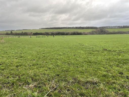 Land for sale in Bakewell, Bakewell, DE45 — £282,000 • 1 bed • 1 bath
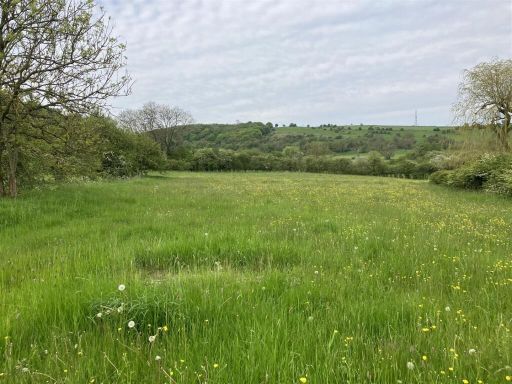 Land for sale in Land off Brookfields, Calver, Hope Valley, S32 — £135,000 • 1 bed • 1 bath
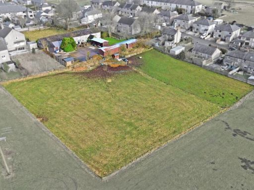 5 bedroom detached house for sale in Meadow Farm, School Road, Peakdale, SK17 8AP, SK17 — £600,000 • 5 bed • 2 bath • 2808 ft²
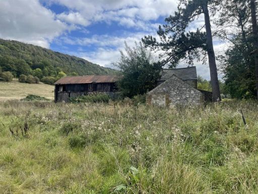 Land for sale in Land and buildings, Coombs Road, Bakewell, DE45 — £400,000 • 1 bed • 1 bath
Meta
- {
"@context": "https://schema.org",
"@type": "Residence",
"name": "Land for sale in Lot 2: Gospel Farm, Bramley Lane, Hassop,…",
"description": "",
"url": "https://propertypiper.co.uk/property/d3c7b123-cfb3-4026-8739-25fa5249c43f",
"image": "https://image-a.propertypiper.co.uk/5aa2d388-51d9-4512-9267-2df0feaf061d-1024.jpeg",
"address": {
"@type": "PostalAddress",
"streetAddress": "Lot 2: Gospel Farm, Bramley Lane, Hassop, Bakewell",
"postalCode": "DE45 1NT",
"addressLocality": "Derbyshire Dales",
"addressRegion": "Derbyshire Dales",
"addressCountry": "England"
},
"geo": {
"@type": "GeoCoordinates",
"latitude": 53.2502245,
"longitude": -1.6542868
},
"numberOfRooms": 1,
"numberOfBathroomsTotal": 1,
"offers": {
"@type": "Offer",
"price": 300000,
"priceCurrency": "GBP",
"availability": "https://schema.org/InStock"
},
"additionalProperty": [
{
"@type": "PropertyValue",
"name": "Feature",
"value": "land"
},
{
"@type": "PropertyValue",
"name": "Feature",
"value": "plot"
},
{
"@type": "PropertyValue",
"name": "Feature",
"value": "rural"
},
{
"@type": "PropertyValue",
"name": "Feature",
"value": "agricultural"
},
{
"@type": "PropertyValue",
"name": "Feature",
"value": "development potential"
},
{
"@type": "PropertyValue",
"name": "Feature",
"value": "green space"
},
{
"@type": "PropertyValue",
"name": "Feature",
"value": "countryside"
},
{
"@type": "PropertyValue",
"name": "Feature",
"value": "agricultural land"
},
{
"@type": "PropertyValue",
"name": "Feature",
"value": "farmland"
},
{
"@type": "PropertyValue",
"name": "Feature",
"value": "pasture"
},
{
"@type": "PropertyValue",
"name": "Feature",
"value": "rural"
},
{
"@type": "PropertyValue",
"name": "Feature",
"value": "undeveloped land"
},
{
"@type": "PropertyValue",
"name": "Feature",
"value": "countryside"
},
{
"@type": "PropertyValue",
"name": "Feature",
"value": "open fields"
},
{
"@type": "PropertyValue",
"name": "Feature",
"value": "potential development"
},
{
"@type": "PropertyValue",
"name": "Feature",
"value": "acreage"
},
{
"@type": "PropertyValue",
"name": "Feature",
"value": "investment land"
},
{
"@type": "PropertyValue",
"name": "Feature",
"value": "nature"
},
{
"@type": "PropertyValue",
"name": "Feature",
"value": "landscape"
},
{
"@type": "PropertyValue",
"name": "Feature",
"value": "expansion"
},
{
"@type": "PropertyValue",
"name": "Feature",
"value": "privacy"
}
]
}
High Res Floorplan Images
Compatible Floorplan Images
FloorplanImages Thumbnail