CM19 5SU - Warehouse for sale in International House, Horsecroft Road,…
View on Property Piper
Warehouse for sale in International House, Horsecroft Road, Harlow, CM19 5SU, CM19
Property Details
- Price: £1
- Bedrooms: 1
- Bathrooms: 1
- Property Type: undefined
- Property SubType: undefined
Brochure Descriptions
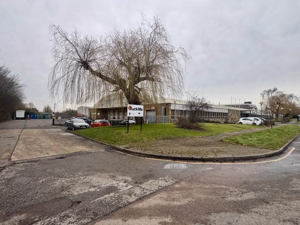
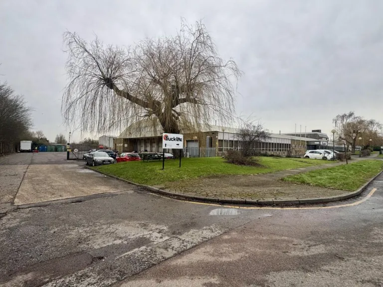
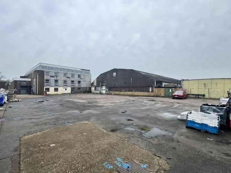
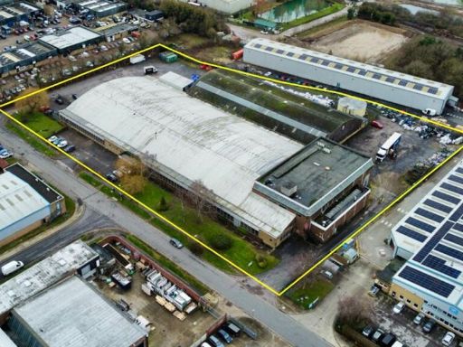
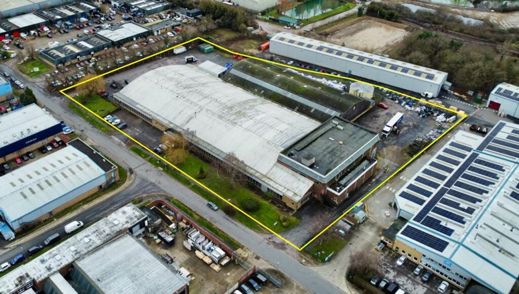
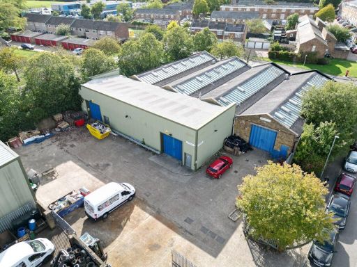
- The properties, Site 1 and Site 2, are large industrial or commercial plots situated in an expansive business area. The sites are highlighted for development opportunities or owner occupation, indicative of their potential for industrial, office, or commercial use. The surrounding area comprises numerous large buildings typical of commercial parks, with access roads suitable for heavy vehicles and transport. The land is flat and open, providing ample space for significant development or operational facilities. The environment is urban, surrounded by factories and other industrial units, with access to main roads and infrastructure conducive to business operations.
- This property is located in Essex, near the vibrant town of Harlow. The location offers easy access to amenities and transport links. While specific details of the property structures or exteriors are not provided in the image, its placement within Harlow suggests a potentially sizeable plot typical of this suburban area, likely offering moderate privacy and space for a family-sized home or a commercial opportunity. The surrounding area is a blend of urban conveniences and lush countryside views, offering a balance of accessibility to city life and the tranquility of open landscapes.
Image Descriptions
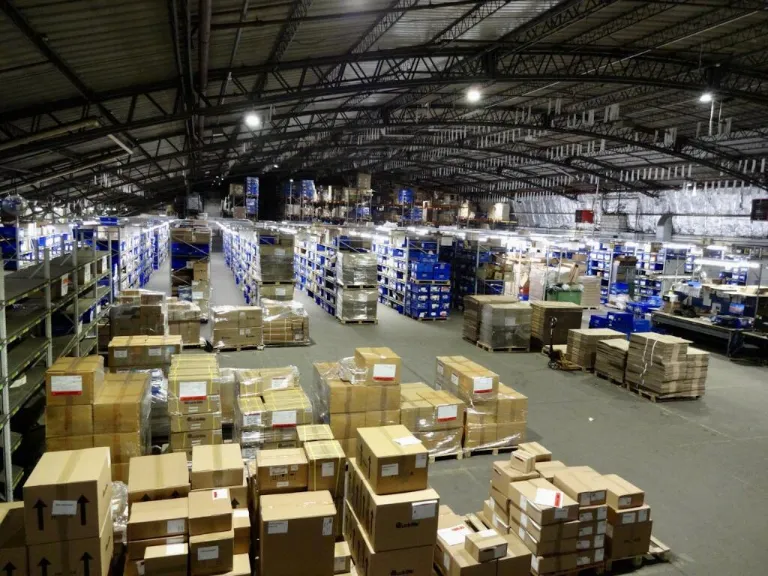
- large warehouse industrial complex industrial
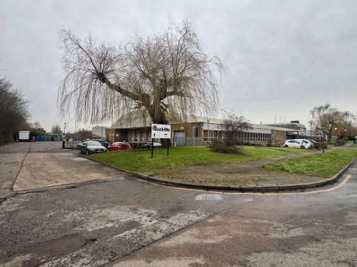
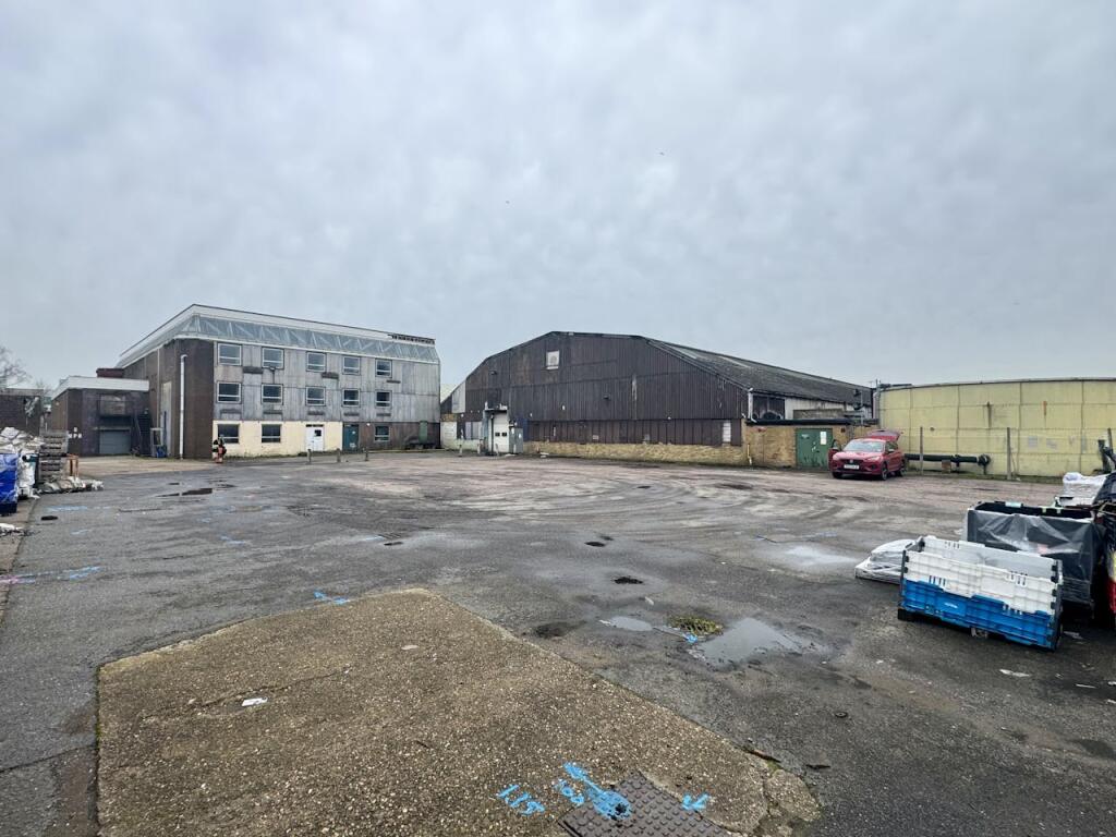
- industrial building mid-20th century industrial
Textual Property Features
Detected Visual Features
- industrial
- warehouse
- commercial property
- large space
- high ceilings
- factory
- industrial complex
- large site
- commercial use
- industrial building
- office space
- industrial estate
- mid-20th century
Nearby Schools
- Nazeing Primary School
- Water Lane Primary Academy
- Longwood Primary Academy
- Jerounds Primary Academy
- William Martin Church of England Infant and Nursery School
- The Downs Primary School and Nursery
- Freshwaters Primary Academy
- Milwards Primary School and Nursery
- Beckmead Moundwood Academy
- Stewards Academy - Science Specialist, Harlow
- St Luke's Catholic Academy
- Sir Frederick Gibberd College
- Hare Street Community Primary School and Nursery
- Roydon Primary Academy
- Little Parndon Primary Academy
- Pemberley Academy
- Hunsdon Junior Mixed and Infant School
- Epping Upland CofE Primary School
- Latton Green Primary Academy
- Kingsmoor Academy
- William Martin Church of England Junior School
- Bmat Stem Academy
- St Alban's Catholic Academy
- St James Church of England Primary School
- Abbotsweld Primary Academy
- Katherines Primary Academy and Nursery
- St Mark's West Essex Catholic School
- Burnt Mill Academy
Nearest Bars And Restaurants
- Id: 2197056066
- Tags:
- Amenity: fast_food
- Name: Atlantic Fish Bar
- TagsNormalized:
- Lat: 51.7658898
- Lon: 0.0840495
- FullGeoHash: u10n3ztnnmrb
- PartitionGeoHash: u10n
- Images:
- FoodStandards: null
- Distance: 1519.9
,- Id: 57921656
- Tags:
- Amenity: pub
- Created_by: Potlatch 0.4a
- Name: The White Horse
- Wikidata: Q26573504
- TagsNormalized:
- Lat: 51.7701965
- Lon: 0.041249
- FullGeoHash: u10n8bqp30j7
- PartitionGeoHash: u10n
- Images:
- FoodStandards: null
- Distance: 1505.2
,- Id: 6270262106
- Tags:
- Amenity: cafe
- Name: Snacksbury Cafe & Bakery
- TagsNormalized:
- Lat: 51.7659374
- Lon: 0.0835283
- FullGeoHash: u10n3zsy6q5h
- PartitionGeoHash: u10n
- Images:
- FoodStandards: null
- Distance: 1484.1
,- Id: 2197437000
- Tags:
- Amenity: pub
- Name: The Cock
- TagsNormalized:
- Lat: 51.7578611
- Lon: 0.0780713
- FullGeoHash: u10n3y0z7hw5
- PartitionGeoHash: u10n
- Images:
- FoodStandards: null
- Distance: 1420.4
,- Id: 2454504640
- Tags:
- Amenity: fast_food
- Cuisine: chinese
- Name: Fortune Inn
- TagsNormalized:
- Lat: 51.7578472
- Lon: 0.0711824
- FullGeoHash: u10n3w5z6dj2
- PartitionGeoHash: u10n
- Images:
- FoodStandards: null
- Distance: 1092.6
}
Nearest General Shops
- Id: 229400394
- Tags:
- Landuse: yes
- Name: Hanns Caravan Storage
- Shop: storage_rental
- Source: https://moderngov.harlow.gov.uk/documents/s16307/Report.pdf
- TagsNormalized:
- caravan
- storage
- storage rental
- shop
- Lat: 51.7790136
- Lon: 0.0806151
- FullGeoHash: u10n9f4dw7wz
- PartitionGeoHash: u10n
- Images:
- FoodStandards: null
- Distance: 1947
,- Id: 137114367
- Tags:
- TagsNormalized:
- Lat: 51.7721495
- Lon: 0.0543059
- FullGeoHash: u10n90zd9kjm
- PartitionGeoHash: u10n
- Images:
- FoodStandards: null
- Distance: 876.8
,- Id: 137114353
- Tags:
- TagsNormalized:
- Lat: 51.7721662
- Lon: 0.0546721
- FullGeoHash: u10n90zf9zq2
- PartitionGeoHash: u10n
- Images:
- FoodStandards: null
- Distance: 863.4
}
Nearest Grocery shops
- Id: 2454504525
- Tags:
- Name: Amo News
- Shop: convenience
- TagsNormalized:
- Lat: 51.7578506
- Lon: 0.0712575
- FullGeoHash: u10n3w5zk6tm
- PartitionGeoHash: u10n
- Images:
- FoodStandards: null
- Distance: 1095.3
,- Id: 2454503137
- Tags:
- Name: Roy's Convenience Store
- Shop: convenience
- TagsNormalized:
- Lat: 51.757877
- Lon: 0.0710538
- FullGeoHash: u10n3w5xrxtd
- PartitionGeoHash: u10n
- Images:
- FoodStandards: null
- Distance: 1084.8
,- Id: 1128526309
- Tags:
- Brand: Texaco
- Brand:wikidata: Q775060
- Building: yes
- Name: Texaco
- Shop: convenience
- TagsNormalized:
- Lat: 51.7671983
- Lon: 0.0670318
- FullGeoHash: u10n3xbvccnw
- PartitionGeoHash: u10n
- Images:
- FoodStandards: null
- Distance: 379.8
}
Nearest Religious buildings
- Id: 765351933
- Tags:
- Amenity: place_of_worship
- Building: church
- Denomination: united_reformed
- Name: Roydon United Reform Church
- Religion: christian
- TagsNormalized:
- place of worship
- church
- united reformed
- christian
- Lat: 51.7714015
- Lon: 0.0461046
- FullGeoHash: u10n909w62dp
- PartitionGeoHash: u10n
- Images:
- FoodStandards: null
- Distance: 1253.9
,- Id: 148806438
- Tags:
- Name: Church End Pond
- Natural: water
- Water: pond
- TagsNormalized:
- Lat: 51.7595276
- Lon: 0.0750066
- FullGeoHash: u10n3ww95g2b
- PartitionGeoHash: u10n
- Images:
- FoodStandards: null
- Distance: 1140
,- Id: 148806440
- Tags:
- Amenity: place_of_worship
- Building: yes
- Denomination: anglican
- Name: St Mary, Great Parndon
- Religion: christian
- Wikidata: Q17536832
- TagsNormalized:
- place of worship
- anglican
- christian
- church
- Lat: 51.7605377
- Lon: 0.0739931
- FullGeoHash: u10n3wtyupt6
- PartitionGeoHash: u10n
- Images:
- FoodStandards: null
- Distance: 1016.8
}
Nearest Medical buildings
- Id: 652920243
- Tags:
- TagsNormalized:
- Lat: 51.7713892
- Lon: 0.0899284
- FullGeoHash: u10nd09qpqrm
- PartitionGeoHash: u10n
- Images:
- FoodStandards: null
- Distance: 2020.6
,- Id: 809346550
- Tags:
- Amenity: pharmacy
- Building: yes
- Dispensing: yes
- Healthcare: pharmacy
- TagsNormalized:
- Lat: 51.7489582
- Lon: 0.072244
- FullGeoHash: u10n3ssee2vp
- PartitionGeoHash: u10n
- Images:
- FoodStandards: null
- Distance: 2006.8
,- Id: 223376271
- Tags:
- Aeroway: helipad
- Name: Princess Alexandra Hospital
- TagsNormalized:
- Lat: 51.7709521
- Lon: 0.0877698
- FullGeoHash: u10n9bxgthvy
- PartitionGeoHash: u10n
- Images:
- FoodStandards: null
- Distance: 1864.4
,- Id: 242400767
- Tags:
- Amenity: hospital
- Emergency: yes
- Healthcare: hospital
- Name: Princess Alexandra Hospital
- Wikidata: Q50573098
- TagsNormalized:
- Lat: 51.7715335
- Lon: 0.0858415
- FullGeoHash: u10n9bwx0324
- PartitionGeoHash: u10n
- Images:
- FoodStandards: null
- Distance: 1760.6
}
Nearest Airports
- Id: 495488524
- Tags:
- Aerodrome: international
- Aerodrome:type: public
- Aeroway: aerodrome
- Alt_name: Stansted
- Iata: STN
- Icao: EGSS
- Is_in: Essex,England,UK
- Name: London Stansted Airport
- Ref: STN
- Source: Gagravarr_Airports
- Website: https://www.stanstedairport.com/
- Wikidata: Q8709
- Wikipedia: en:London Stansted Airport
- TagsNormalized:
- airport
- international airport
- Lat: 51.8869677
- Lon: 0.2429264
- FullGeoHash: u10pjt8zkxg4
- PartitionGeoHash: u10p
- Images:
- FoodStandards: null
- Distance: 18331.8
,- Id: 103894219
- Tags:
- Aerodrome: international
- Aeroway: aerodrome
- Iata: SEN
- Icao: EGMC
- Name: London Southend Airport
- Old_name: Southend Municipal Airport
- Ref: SEN
- Wikidata: Q1415441
- TagsNormalized:
- airport
- international airport
- Lat: 51.5701749
- Lon: 0.6924624
- FullGeoHash: u10mru04p937
- PartitionGeoHash: u10m
- Images:
- FoodStandards: null
- Distance: 48621.9
,- Id: 121158889
- Tags:
- Aerodrome: continental
- Aeroway: aerodrome
- Fhrs:
- Authority: City of London Corporation
- Iata: LCY
- Icao: EGLC
- Name: London City Airport
- Operator: London City Airport Limited
- Ref: LCY
- Website: https://www.londoncityairport.com/
- Wikidata: Q8982
- Wikipedia: en:London City Airport
- TagsNormalized:
- airport
- continental airport
- Lat: 51.5042658
- Lon: 0.0539987
- FullGeoHash: u10j10p64702
- PartitionGeoHash: u10j
- Images:
- FoodStandards: null
- Distance: 29091.6
}
Nearest Leisure Facilities
- Id: 243708349
- Tags:
- TagsNormalized:
- Lat: 51.7663183
- Lon: 0.0727658
- FullGeoHash: u10n3xubxt4h
- PartitionGeoHash: u10n
- Images:
- FoodStandards: null
- Distance: 745.3
,- Id: 223415055
- Tags:
- Leisure: pitch
- Lit: yes
- Sport: soccer
- TagsNormalized:
- Lat: 51.7710437
- Lon: 0.067813
- FullGeoHash: u10n989khnj0
- PartitionGeoHash: u10n
- Images:
- FoodStandards: null
- Distance: 704.3
,- Id: 208406953
- Tags:
- Leisure: stadium
- Name: Harlow Arena
- TagsNormalized:
- Lat: 51.7710222
- Lon: 0.0677486
- FullGeoHash: u10n989k4dj0
- PartitionGeoHash: u10n
- Images:
- FoodStandards: null
- Distance: 699.8
,- Id: 208406982
- Tags:
- Leisure: stadium
- Name: Harlow Greyhound Stadium
- Sport: dog_racing
- Wikidata: Q5658986
- Wikipedia: en:Harlow Stadium
- TagsNormalized:
- Lat: 51.7719956
- Lon: 0.063732
- FullGeoHash: u10n92y3tp6p
- PartitionGeoHash: u10n
- Images:
- FoodStandards: null
- Distance: 694.5
,- Id: 243551206
- Tags:
- TagsNormalized:
- Lat: 51.765248
- Lon: 0.0697192
- FullGeoHash: u10n3xdf2tdk
- PartitionGeoHash: u10n
- Images:
- FoodStandards: null
- Distance: 537.9
}
Nearest Tourist attractions
- Id: 45081069
- Tags:
- Name: Ada Cole Rescue Stables
- Tourism: attraction
- TagsNormalized:
- Lat: 51.7470155
- Lon: 0.0600881
- FullGeoHash: u10n3k7b0nug
- PartitionGeoHash: u10n
- Images:
- FoodStandards: null
- Distance: 2097.9
,- Id: 1502871254
- Tags:
- Man_made: village_sign
- Name: Village Sign
- Tourism: attraction
- TagsNormalized:
- Lat: 51.7731966
- Lon: 0.0398705
- FullGeoHash: u10n8cj09p3e
- PartitionGeoHash: u10n
- Images:
- FoodStandards: null
- Distance: 1726
,- Id: 1502733056
- Tags:
- Name: Stocks & Lock-up
- Tourism: attraction
- TagsNormalized:
- Lat: 51.7728907
- Lon: 0.0397173
- FullGeoHash: u10n8buyvqr6
- PartitionGeoHash: u10n
- Images:
- FoodStandards: null
- Distance: 1719.5
}
Nearest Train stations
- Id: 6137852392
- Tags:
- Name: Broxbourne
- Naptan:
- Network: National Rail
- Platforms: 4
- Public_transport: station
- Railway: station
- Ref:
- Wikidata: Q2968226
- Wikipedia: en:Broxbourne railway station
- TagsNormalized:
- Lat: 51.7468426
- Lon: -0.0106626
- FullGeoHash: gcpyru0ppw97
- PartitionGeoHash: gcpy
- Images:
- FoodStandards: null
- Distance: 5427.1
,- Id: 6137915989
- Tags:
- Name: St Margarets
- Naptan:
- Network: National Rail
- Platforms: 2
- Public_transport: station
- Railway: station
- Ref:
- Wikidata: Q2047890
- Wikipedia: en:St Margarets railway station (Hertfordshire)
- TagsNormalized:
- Lat: 51.7879595
- Lon: 0.0010843
- FullGeoHash: u10n858y9r2e
- PartitionGeoHash: u10n
- Images:
- FoodStandards: null
- Distance: 4856.8
,- Id: 6137915990
- Tags:
- Name: Rye House
- Naptan:
- Network: National Rail
- Platforms: 2
- Public_transport: station
- Railway: station
- Ref:
- Wikidata: Q1976943
- Wikipedia: en:Rye House railway station
- TagsNormalized:
- Lat: 51.7693606
- Lon: 0.0055296
- FullGeoHash: u10n80k42u70
- PartitionGeoHash: u10n
- Images:
- FoodStandards: null
- Distance: 3903
,- Id: 6137852394
- Tags:
- Name: Harlow Town
- Naptan:
- Network: National Rail
- Public_transport: station
- Railway: station
- Ref:
- Wikidata: Q1988068
- Wikipedia: en:Harlow Town railway station
- TagsNormalized:
- Lat: 51.781287
- Lon: 0.0950305
- FullGeoHash: u10nd4mpy7eb
- PartitionGeoHash: u10n
- Images:
- FoodStandards: null
- Distance: 2850.3
,- Id: 6137852393
- Tags:
- Name: Roydon
- Naptan:
- Network: National Rail
- Platforms: 2
- Public_transport: station
- Railway: station
- Ref:
- Source_ref: GPS survey
- Wikidata: Q2039157
- Wikipedia: en:Roydon railway station
- TagsNormalized:
- Lat: 51.775456
- Lon: 0.0355326
- FullGeoHash: u10n8c3vgux1
- PartitionGeoHash: u10n
- Images:
- FoodStandards: null
- Distance: 2109.3
}
Nearest Hotels
- Id: 2629427091
- Tags:
- Brand: Holiday Inn Express
- Brand:wikidata: Q5880423
- Brand:wikipedia: en:Holiday Inn Express
- Name: Holiday Inn Express Harlow
- Tourism: hotel
- TagsNormalized:
- Lat: 51.7692955
- Lon: 0.0967175
- FullGeoHash: u10nd0q6j8ju
- PartitionGeoHash: u10n
- Images:
- FoodStandards: null
- Distance: 2422.1
,- Id: 552855940
- Tags:
- Addr:
- Name: Roydon Mill Estate
- Tourism: hotel
- TagsNormalized:
- Lat: 51.7735067
- Lon: 0.0311764
- FullGeoHash: u10n89ndw3nv
- PartitionGeoHash: u10n
- Images:
- FoodStandards: null
- Distance: 2283.2
,- Id: 252709957
- Tags:
- Created_by: Potlatch 0.7b
- Name: Briggens House Hotel
- Tourism: hotel
- Wikidata: Q26594622
- TagsNormalized:
- Lat: 51.7818004
- Lon: 0.0483957
- FullGeoHash: u10n94e4zenr
- PartitionGeoHash: u10n
- Images:
- FoodStandards: null
- Distance: 2004.6
}
Tags
- industrial
- warehouse
- commercial property
- large space
- high ceilings
- factory
- industrial complex
- large site
- commercial use
- industrial building
- commercial property
- large space
- warehouse
- factory
- office space
- industrial estate
- mid-20th century
Local Market Stats
- Average Price/sqft: £358
- Avg Income: £45300
- Rental Yield: 5%
- Social Housing: 20%
- Planning Success Rate: 68%
Similar Properties
 Distribution warehouse for sale in 1-4 Ployters Road, Staple Tye, Harlow, CM18 7PS, CM18 — £1,400,000 • 1 bed • 1 bath • 12367 ft²
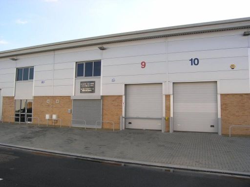 Distribution warehouse for sale in Unit 9 RO24, Harlow Business Park, Harlow, CM19 5QB, CM19 — £445,000 • 1 bed • 1 bath • 1609 ft²
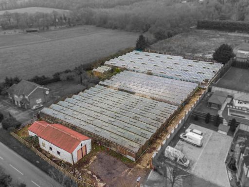 Residential development for sale in Hamlet Hill, CM19 — £1,650,000 • 4 bed • 2 bath • 1593 ft²
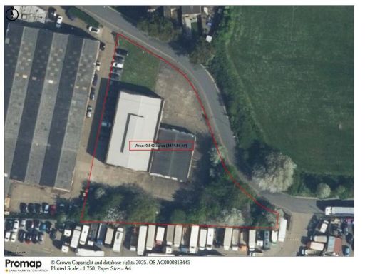 Warehouse for sale in New Ford Business Centre, New Ford Road, Waltham Cross, EN8 7PG, EN8 — POA • 1 bed • 1 bath • 10165 ft²
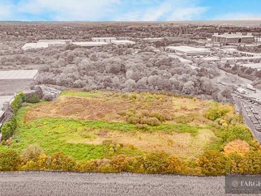 Land for sale in Old House Lane, Harlow, CM19 — £3,500,000 • 1 bed • 1 bath
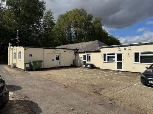 Commercial property for sale in Hastingwood Road, Hastingwood, Harlow, CM17 — £850,000 • 1 bed • 1 bath • 4326 ft²
Meta
- {
"@context": "https://schema.org",
"@type": "Residence",
"name": "Warehouse for sale in International House, Horsecroft Road,…",
"description": "",
"url": "https://propertypiper.co.uk/property/c3ddc20c-c4ef-408b-b51e-da8d2e529df7",
"image": "https://image-a.propertypiper.co.uk/01ef8cd2-cd09-4079-b693-a884a9120a72-1024.jpeg",
"address": {
"@type": "PostalAddress",
"streetAddress": "INTERNATIONAL HOUSE, HORSECROFT ROAD",
"postalCode": "CM19 5SU",
"addressLocality": "Harlow",
"addressRegion": "Harlow",
"addressCountry": "England"
},
"geo": {
"@type": "GeoCoordinates",
"latitude": 51.76584655942423,
"longitude": 0.06196288223536186
},
"numberOfRooms": 1,
"numberOfBathroomsTotal": 1,
"offers": {
"@type": "Offer",
"price": 1,
"priceCurrency": "GBP",
"availability": "https://schema.org/InStock"
},
"additionalProperty": [
{
"@type": "PropertyValue",
"name": "Feature",
"value": "industrial"
},
{
"@type": "PropertyValue",
"name": "Feature",
"value": "warehouse"
},
{
"@type": "PropertyValue",
"name": "Feature",
"value": "commercial property"
},
{
"@type": "PropertyValue",
"name": "Feature",
"value": "large space"
},
{
"@type": "PropertyValue",
"name": "Feature",
"value": "high ceilings"
},
{
"@type": "PropertyValue",
"name": "Feature",
"value": "factory"
},
{
"@type": "PropertyValue",
"name": "Feature",
"value": "industrial complex"
},
{
"@type": "PropertyValue",
"name": "Feature",
"value": "large site"
},
{
"@type": "PropertyValue",
"name": "Feature",
"value": "commercial use"
},
{
"@type": "PropertyValue",
"name": "Feature",
"value": "industrial building"
},
{
"@type": "PropertyValue",
"name": "Feature",
"value": "commercial property"
},
{
"@type": "PropertyValue",
"name": "Feature",
"value": "large space"
},
{
"@type": "PropertyValue",
"name": "Feature",
"value": "warehouse"
},
{
"@type": "PropertyValue",
"name": "Feature",
"value": "factory"
},
{
"@type": "PropertyValue",
"name": "Feature",
"value": "office space"
},
{
"@type": "PropertyValue",
"name": "Feature",
"value": "industrial estate"
},
{
"@type": "PropertyValue",
"name": "Feature",
"value": "mid-20th century"
}
]
}