GL55 6NN - House for sale in Lot 1: Oakham Farm, Nashs Lane, Ebrington…
View on Property Piper
House for sale in Lot 1: Oakham Farm, Nashs Lane, Ebrington, Gloucestershire, GL55
Property Details
- Price: £2000000
- Bedrooms: 1
- Bathrooms: 1
- Property Type: undefined
- Property SubType: undefined
Brochure Descriptions
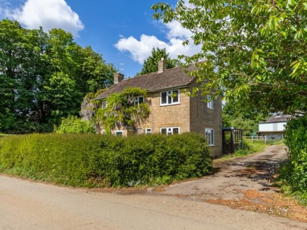
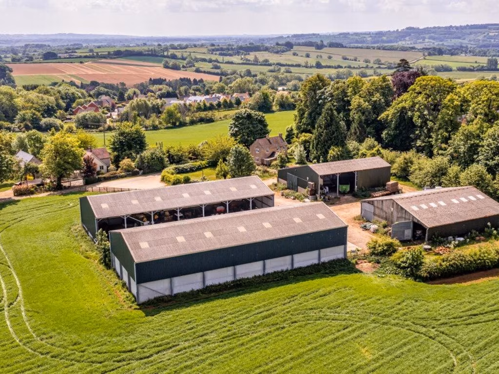
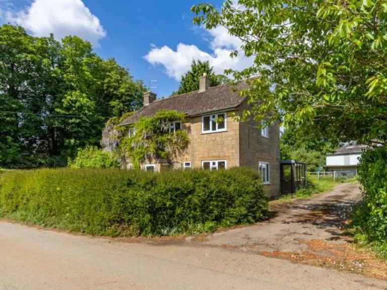
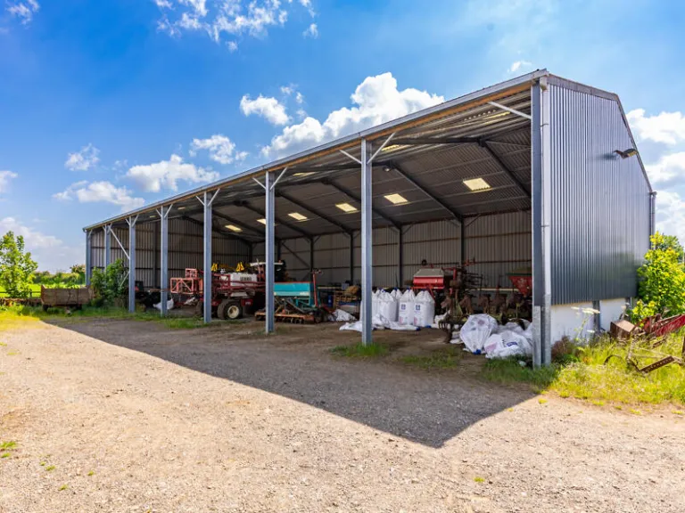
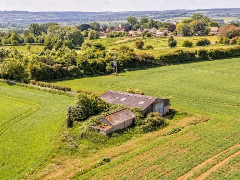
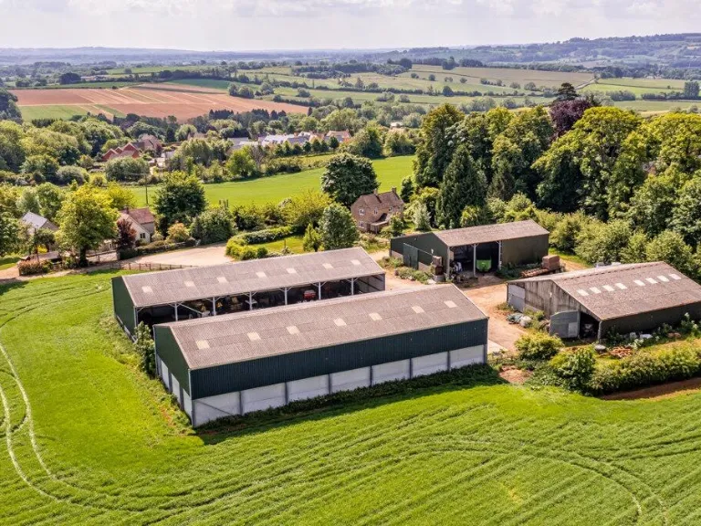
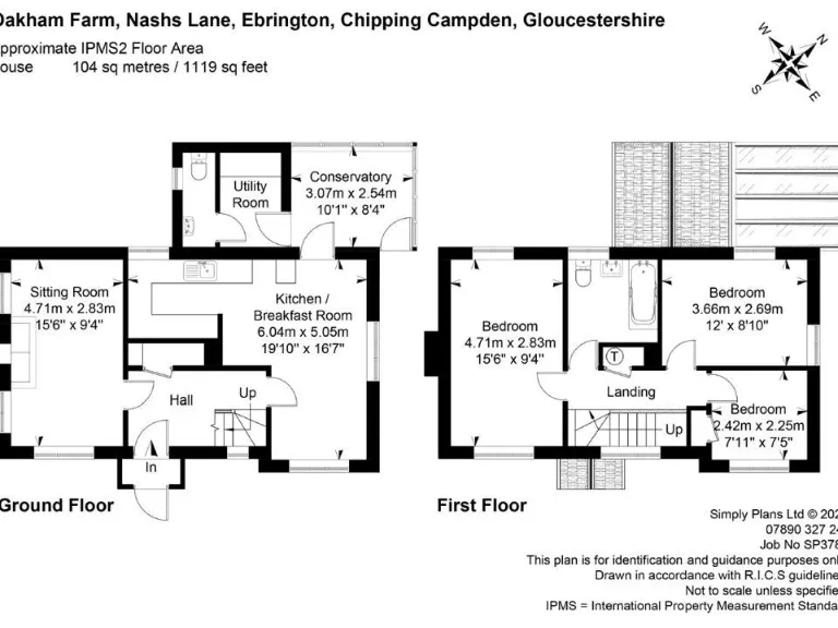
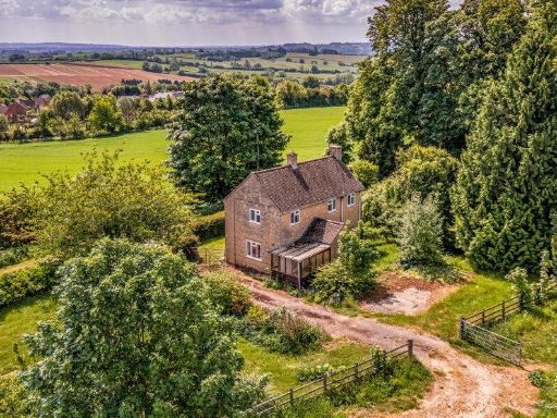
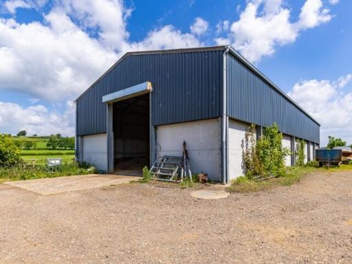
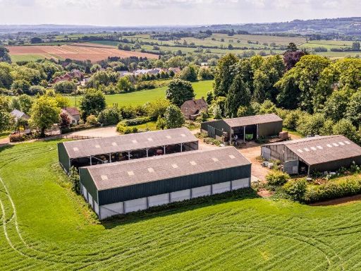
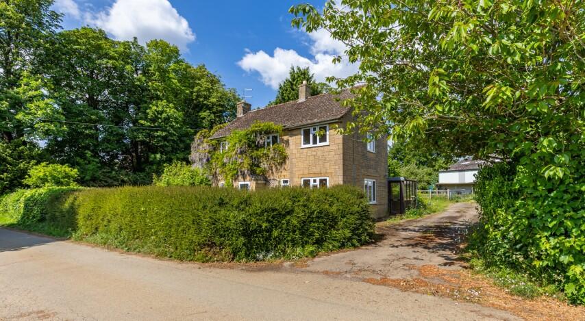
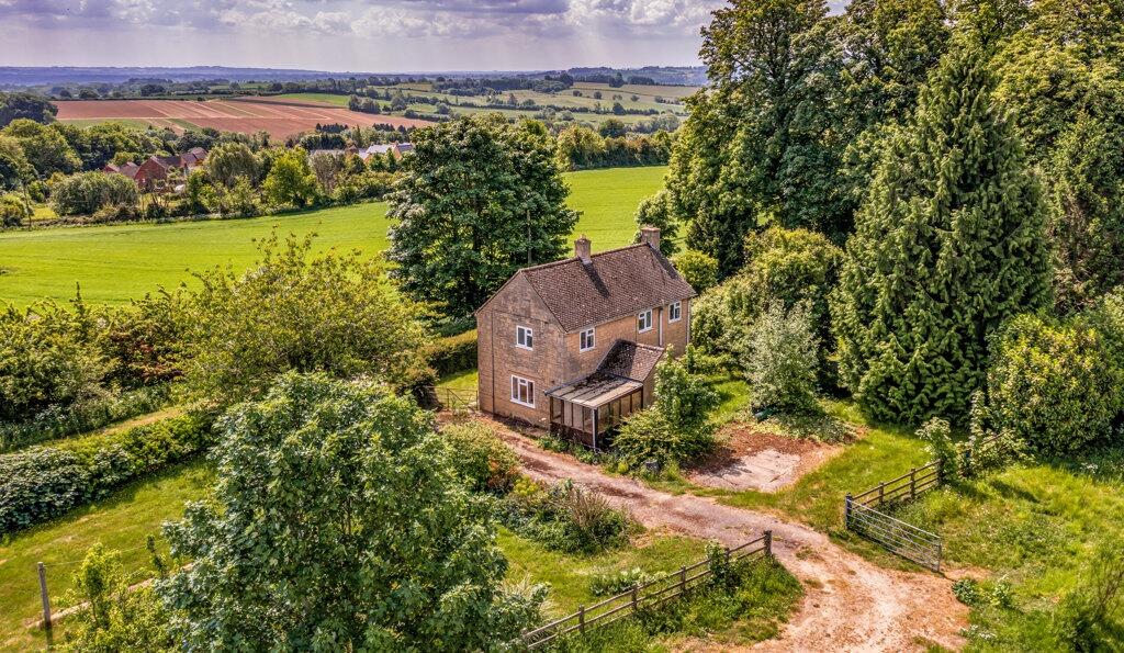
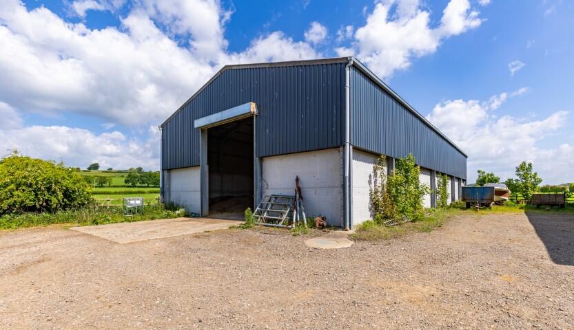
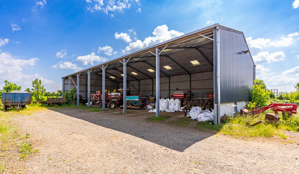
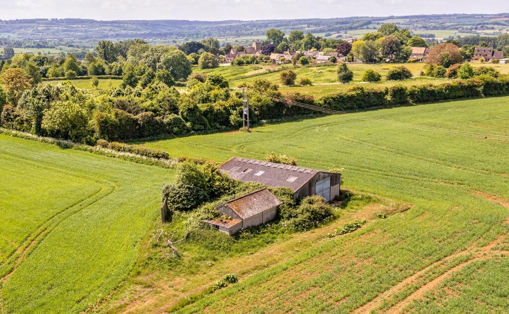
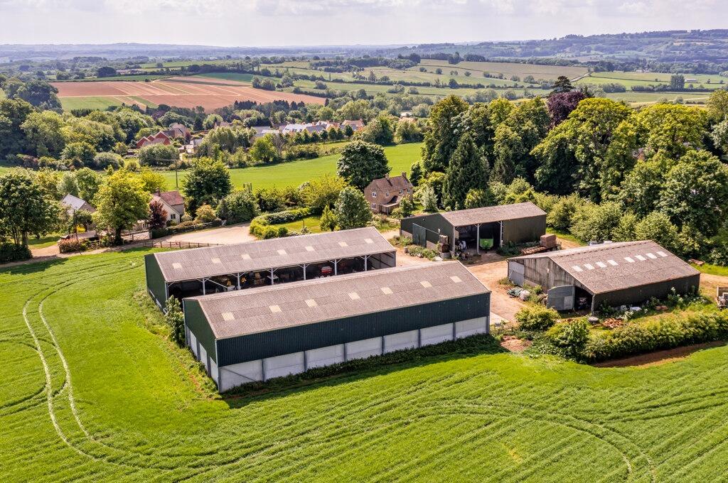
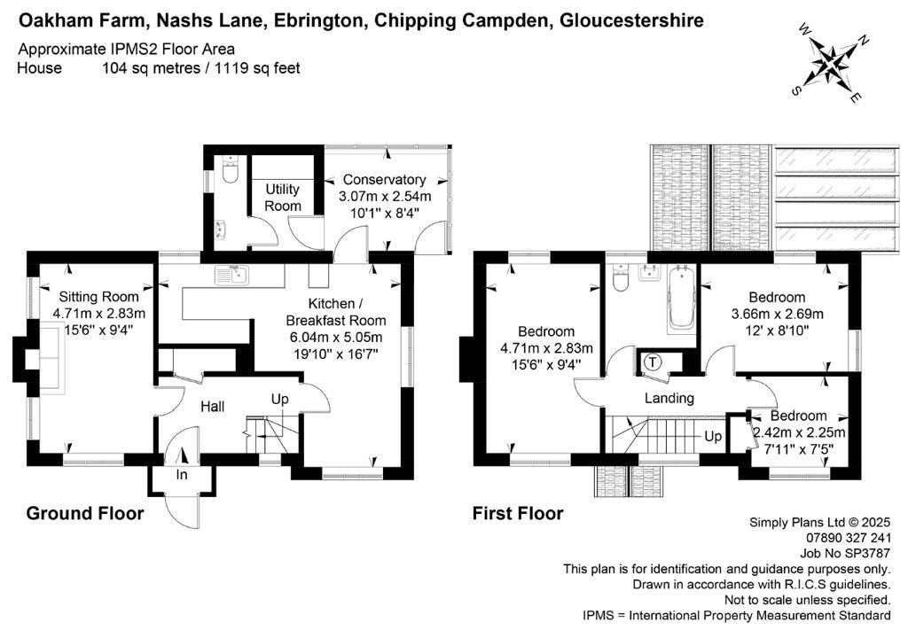
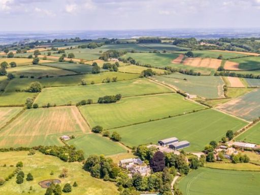
- The property is a sprawling 175-acre arable farm situated in a picturesque rural setting with expansive views over fields and woodlands, contributing to an exceptional and serene countryside landscape. The farmhouse itself offers ample space with three bedrooms, suitable for a family seeking rural tranquility. The estate includes multiple outbuildings, which are primarily agricultural in design, providing significant potential for versatility and practical use. The overall property size is substantial due to the vast surrounding lands, offering both privacy and considerable opportunity for agricultural pursuits.
- The property for sale, Oakham Farm, is situated in the idyllic countryside of Ebrington, Chipping Campden, offering picturesque rural views. Based on its name, it is likely to be a large farm property, potentially featuring expansive grounds and agricultural land. The overall property size is likely substantial, suitable for farming or equestrian activities.
Image Descriptions
- detached house Mid-20th Century
- country house mid-20th century rural
Textual Property Features
Detected Visual Features
- detached house
- Mid-20th Century
- overgrown vegetation
- potential curb appeal
- renovation opportunity
- off-street parking
- rural setting
- country property
- rural house
- detached
- countryside setting
- secluded
- nature
- land
- trees
- privacy
- renovation potential
EPC Details
- Fully double glazed
- Solid brick, with external insulation
- Boiler and radiators, oil
- Low energy lighting in all fixed outlets
- Solid, insulated (assumed)
Nearby Schools
- Shipston-on-Stour Primary School
- Quinton Primary School
- Blockley Church of England Primary School
- St Catharine's Catholic Primary School
- Shipston High School
- Ilmington CofE Primary School
- St James and Ebrington Church of England Primary School
- Chipping Campden School
- Honeybourne Primary Academy
- Tudor Grange Primary Academy Meon Vale
- Pebworth First School
- Newbold and Tredington CofE Primary School
- Mickleton Primary School
Nearest Bars And Restaurants
- Id: 1270226200
- Tags:
- Amenity: cafe
- Name: Winthrop's Café
- Opening_hours: Mo-Su 10:00-17:00
- TagsNormalized:
- Lat: 52.0839151
- Lon: -1.7444542
- FullGeoHash: gcqb239dz32x
- PartitionGeoHash: gcqb
- Images:
- FoodStandards: null
- Distance: 2761
,- Id: 380309265
- Tags:
- Amenity: cafe
- Name: Barn Café
- Source: survey
- TagsNormalized:
- Lat: 52.084126
- Lon: -1.7433065
- FullGeoHash: gcqb23ds40b3
- PartitionGeoHash: gcqb
- Images:
- FoodStandards: null
- Distance: 2748.4
,- Id: 8511365372
- Tags:
- Amenity: pub
- Name: Little Oak Vineyard
- TagsNormalized:
- Lat: 52.0522501
- Lon: -1.7564241
- FullGeoHash: gcqb05c426eq
- PartitionGeoHash: gcqb
- Images:
- FoodStandards: null
- Distance: 2296.7
,- Id: 1076402907
- Tags:
- Amenity: cafe
- Name: Vegetable Matters
- TagsNormalized:
- Lat: 52.0534075
- Lon: -1.7342499
- FullGeoHash: gcqb0s11j43w
- PartitionGeoHash: gcqb
- Images:
- FoodStandards: null
- Distance: 1059.2
,- Id: 1076402912
- Tags:
- Amenity: pub
- Building: yes
- Name: The Ebrington Arms
- Source: survey
- TagsNormalized:
- Lat: 52.0578122
- Lon: -1.7319265
- FullGeoHash: gcqb0sffepw1
- PartitionGeoHash: gcqb
- Images:
- FoodStandards: null
- Distance: 565.5
}
Nearest General Shops
- Id: 5758985170
- Tags:
- Name: National Trust Gift Shop
- Shop: gift
- TagsNormalized:
- Lat: 52.0839403
- Lon: -1.7440793
- FullGeoHash: gcqb23d4bn0j
- PartitionGeoHash: gcqb
- Images:
- FoodStandards: null
- Distance: 2752.3
,- Id: 111505022
- Tags:
- Building: yes
- Shop: garden_centre
- TagsNormalized:
- Lat: 52.0840433
- Lon: -1.7434605
- FullGeoHash: gcqb23d7w3ms
- PartitionGeoHash: gcqb
- Images:
- FoodStandards: null
- Distance: 2744.5
,- Id: 9870857180
- Tags:
- TagsNormalized:
- Lat: 52.0533869
- Lon: -1.7343619
- FullGeoHash: gcqb0s10fqw5
- PartitionGeoHash: gcqb
- Images:
- FoodStandards: null
- Distance: 1065
}
Nearest Grocery shops
- Id: 336272289
- Tags:
- TagsNormalized:
- Lat: 52.0910873
- Lon: -1.6914383
- FullGeoHash: gcqb3dbkddkp
- PartitionGeoHash: gcqb
- Images:
- FoodStandards: null
- Distance: 4056.4
,- Id: 1659048326
- Tags:
- Name: The co-operative food
- Shop: convenience
- TagsNormalized:
- the co-operative food
- food
- convenience
- shop
- Lat: 52.0504232
- Lon: -1.7809873
- FullGeoHash: gcq8p7rpeyps
- PartitionGeoHash: gcq8
- Images:
- FoodStandards: null
- Distance: 3927.9
,- Id: 454822993
- Tags:
- Addr:
- City: Ilmington
- Postcode: CV36 4LE
- Street: Grump Street
- Building: yes
- Name: Ilmington Community Shop
- Shop: convenience
- Website: http://www.ilmingtonshop.co.uk/
- TagsNormalized:
- Lat: 52.0878036
- Lon: -1.6940077
- FullGeoHash: gcqb36q3qy27
- PartitionGeoHash: gcqb
- Images:
- FoodStandards: null
- Distance: 3658.8
}
Nearest Supermarkets
- Id: 146911956
- Tags:
- Building: yes
- Name: Tesco Express
- Shop: supermarket
- Source: visual survey;bing
- TagsNormalized:
- tesco
- tesco express
- supermarket
- shop
- Lat: 52.0640923
- Lon: -1.6240261
- FullGeoHash: gcqb5jcrm6nr
- PartitionGeoHash: gcqb
- Images:
- FoodStandards: null
- Distance: 7012.3
,- Id: 146636501
- Tags:
- Addr:
- Brand: Co-op Food
- Brand:wikidata: Q3277439
- Brand:wikipedia: en:Co-op Food
- Building: yes
- Name: Co-op Food
- Operator: Co-operative Group
- Shop: supermarket
- Source: bing
- TagsNormalized:
- co-op
- co-op food
- food
- supermarket
- shop
- Lat: 52.0627106
- Lon: -1.6248674
- FullGeoHash: gcqb5j8z3bej
- PartitionGeoHash: gcqb
- Images:
- FoodStandards: null
- Distance: 6950.6
,- Id: 146636497
- Tags:
- Addr:
- Housenumber: 3-5
- Postcode: CV36 4AB
- Street: High Street
- Brand: Co-op Food
- Brand:wikidata: Q3277439
- Brand:wikipedia: en:Co-op Food
- Building: yes
- Name: Co-op Food
- Operator: Midcounties Co-operative
- Shop: supermarket
- Source: bing
- TagsNormalized:
- co-op
- co-op food
- food
- supermarket
- shop
- Lat: 52.062891
- Lon: -1.6251114
- FullGeoHash: gcqb5jb8k4m1
- PartitionGeoHash: gcqb
- Images:
- FoodStandards: null
- Distance: 6934.3
}
Nearest Religious buildings
- Id: 519286873
- Tags:
- Amenity: pub
- Building: yes
- Name: The Churchill Arms
- TagsNormalized:
- Lat: 52.0386661
- Lon: -1.7319419
- FullGeoHash: gcqb096g4y6w
- PartitionGeoHash: gcqb
- Images:
- FoodStandards: null
- Distance: 2583.9
,- Id: 360747222
- Tags:
- Amenity: place_of_worship
- Building: church
- Denomination: anglican
- Heritage: 2
- Heritage:operator: Historic England
- Listed_status: Grade I
- Name: St. Eadburgha
- Religion: christian
- Wikidata: Q17524735
- TagsNormalized:
- place of worship
- church
- anglican
- christian
- Lat: 52.0580164
- Lon: -1.7334242
- FullGeoHash: gcqb0scgbm95
- PartitionGeoHash: gcqb
- Images:
- FoodStandards: null
- Distance: 622.1
,- Id: 391197329
- Tags:
- Amenity: school
- Denomination: anglican
- Isced:
- Name: St James and Ebrington Church of England Primary School
- Note: Two sites - one in Chipping Campden and one in Ebrington
- Ref:
- Religion: christian
- Website: http://www.stjamesandebringtonschool.org.uk/
- TagsNormalized:
- school
- anglican
- church
- christian
- Lat: 52.0587438
- Lon: -1.7320844
- FullGeoHash: gcqb0t48pt0q
- PartitionGeoHash: gcqb
- Images:
- FoodStandards: null
- Distance: 499.9
}
Nearest Medical buildings
- Id: 598414032
- Tags:
- Amenity: pharmacy
- Brand: Boots
- Brand:wikidata: Q6123139
- Brand:wikipedia: en:Boots UK
- Building: yes
- Dispensing: yes
- Healthcare: pharmacy
- Name: Boots
- Source: Bing
- TagsNormalized:
- pharmacy
- boots
- health
- healthcare
- Lat: 52.0636705
- Lon: -1.6245487
- FullGeoHash: gcqb5jchc78e
- PartitionGeoHash: gcqb
- Images:
- FoodStandards: null
- Distance: 6974.9
,- Id: 692803663
- Tags:
- Amenity: doctors
- Building: yes
- Healthcare: doctor
- Name: Meon Medical Centre
- Source: survey
- TagsNormalized:
- doctor
- doctors
- health
- healthcare
- Lat: 52.1196248
- Lon: -1.7422199
- FullGeoHash: gcqb8256g668
- PartitionGeoHash: gcqb
- Images:
- FoodStandards: null
- Distance: 6533.5
,- Id: 136880239
- Tags:
- Amenity: doctors
- Building: yes
- Healthcare: doctor
- Name: The Surgery
- Source: visual survey;bing
- TagsNormalized:
- doctor
- doctors
- health
- healthcare
- surgery
- Lat: 52.0141253
- Lon: -1.7650813
- FullGeoHash: gcnxzufsnxez
- PartitionGeoHash: gcnx
- Images:
- FoodStandards: null
- Distance: 5907.4
,- Id: 1583408880
- Tags:
- Amenity: pharmacy
- Healthcare: pharmacy
- TagsNormalized:
- Lat: 52.0519065
- Lon: -1.7785825
- FullGeoHash: gcq8pebbk48u
- PartitionGeoHash: gcq8
- Images:
- FoodStandards: null
- Distance: 3720.9
}
Nearest Leisure Facilities
- Id: 983006015
- Tags:
- Access: private
- Leisure: park
- Source: bing
- TagsNormalized:
- Lat: 52.0576875
- Lon: -1.7346029
- FullGeoHash: gcqb0sbfhb63
- PartitionGeoHash: gcqb
- Images:
- FoodStandards: null
- Distance: 707.5
,- Id: 364954404
- Tags:
- Leisure: playground
- Note: Swings, toddler swing, climbing frame, tree trunk
- Source: Bing, knowledge
- TagsNormalized:
- Lat: 52.0622587
- Lon: -1.7338814
- FullGeoHash: gcqb0t9ktskq
- PartitionGeoHash: gcqb
- Images:
- FoodStandards: null
- Distance: 507.2
,- Id: 364954600
- Tags:
- Leisure: pitch
- Lit: no
- Source: Bing, knowledge
- Sport: soccer
- Surface: grass
- TagsNormalized:
- Lat: 52.0624488
- Lon: -1.732889
- FullGeoHash: gcqb0tdjszbk
- PartitionGeoHash: gcqb
- Images:
- FoodStandards: null
- Distance: 443.7
,- Id: 245470113
- Tags:
- Landuse: meadow
- Leisure: garden
- Source: bing
- TagsNormalized:
- Lat: 52.0613422
- Lon: -1.7213051
- FullGeoHash: gcqb0v6x69tf
- PartitionGeoHash: gcqb
- Images:
- FoodStandards: null
- Distance: 358.6
,- Id: 1077617654
- Tags:
- Access: private
- Leisure: pitch
- Source: bing
- Sport: tennis
- TagsNormalized:
- Lat: 52.0605438
- Lon: -1.7281224
- FullGeoHash: gcqb0tmdeuf8
- PartitionGeoHash: gcqb
- Images:
- FoodStandards: null
- Distance: 165.7
}
Nearest Tourist attractions
- Id: 246650420
- Tags:
- Building: yes
- Heritage: 2
- Heritage:operator: Historic England
- Listed_status: Grade II
- Name: Court Barn
- Tourism: museum
- TagsNormalized:
- Lat: 52.0524992
- Lon: -1.7762574
- FullGeoHash: gcq8pefef1nk
- PartitionGeoHash: gcq8
- Images:
- FoodStandards: null
- Distance: 3549.7
,- Id: 184910353
- Tags:
- Alt_name: Kiftsgate Court Garden
- Name: Kiftsgate Court
- Tourism: attraction
- TagsNormalized:
- Lat: 52.0857896
- Lon: -1.7527321
- FullGeoHash: gcqb21gtwquj
- PartitionGeoHash: gcqb
- Images:
- FoodStandards: null
- Distance: 3225.6
,- Id: 380309283
- Tags:
- Source: survey
- Tourism: picnic_site
- TagsNormalized:
- Lat: 52.0855242
- Lon: -1.7434178
- FullGeoHash: gcqb23fkpmmq
- PartitionGeoHash: gcqb
- Images:
- FoodStandards: null
- Distance: 2893.5
}
Nearest Train stations
- Id: 966924198
- Tags:
- Public_transport: station
- Railway: station
- Usage: tourism
- Wheelchair: no
- TagsNormalized:
- Lat: 52.1141441
- Lon: -1.9348538
- FullGeoHash: gcq87zp4fss6
- PartitionGeoHash: gcq8
- Images:
- FoodStandards: null
- Distance: 15383.6
,- Id: 31554736
- Tags:
- Name: Stratford-upon-Avon
- Naptan:
- Network: National Rail
- Public_transport: station
- Railway: station
- Ref:
- Wheelchair: yes
- Wikidata: Q1941516
- Wikipedia: en:Stratford-upon-Avon railway station
- TagsNormalized:
- Lat: 52.1944695
- Lon: -1.7163221
- FullGeoHash: gcqbbvwnyf36
- PartitionGeoHash: gcqb
- Images:
- FoodStandards: null
- Distance: 14783.7
,- Id: 5384060504
- Tags:
- Name: Broadway
- Operator: Gloucestershire Warwickshire Railway
- Public_transport: station
- Railway: station
- Usage: tourism
- Wikidata: Q4972554
- TagsNormalized:
- Lat: 52.043006
- Lon: -1.8720529
- FullGeoHash: gcq8j6hu6p2p
- PartitionGeoHash: gcq8
- Images:
- FoodStandards: null
- Distance: 10164.9
,- Id: 6609023833
- Tags:
- Name: Honeybourne
- Naptan:
- Network: National Rail
- Operator: Great Western Railway
- Public_transport: station
- Railway: station
- Ref:
- Source: NPE;local knowledge
- Wikidata: Q5373459
- Wikipedia: en:Honeybourne railway station
- TagsNormalized:
- Lat: 52.1016406
- Lon: -1.8336821
- FullGeoHash: gcq8qkbf01g8
- PartitionGeoHash: gcq8
- Images:
- FoodStandards: null
- Distance: 8566.1
,- Id: 6609023831
- Tags:
- Name: Moreton-in-Marsh
- Naptan:
- Network: National Rail
- Operator: First Great Western
- Public_transport: station
- Railway: station
- Ref:
- Wikidata: Q2369749
- Wikipedia: en:Moreton-in-Marsh railway station
- TagsNormalized:
- Lat: 51.9921819
- Lon: -1.7002657
- FullGeoHash: gcnzc2cukvnj
- PartitionGeoHash: gcnz
- Images:
- FoodStandards: null
- Distance: 7932.2
}
Nearest Hotels
- Id: 339469196
- Tags:
- Addr:
- Postcode: GL55 6AT
- Street: High Street
- Name: Noel Arms Hotel
- Source: survey
- Tourism: hotel
- Website: http://www.noelarmshotel.com/
- Wikidata: Q26348258
- TagsNormalized:
- Lat: 52.0502537
- Lon: -1.7813868
- FullGeoHash: gcq8p7qydwt9
- PartitionGeoHash: gcq8
- Images:
- FoodStandards: null
- Distance: 3959.8
,- Id: 601811495
- Tags:
- Building: yes
- Name: Lygon Arms Hotel
- Tourism: hotel
- Wikidata: Q26467323
- TagsNormalized:
- Lat: 52.0511955
- Lon: -1.7791944
- FullGeoHash: gcq8pe8kjy07
- PartitionGeoHash: gcq8
- Images:
- FoodStandards: null
- Distance: 3784.6
,- Id: 636904435
- Tags:
- Addr:
- Postcode: GL55 6JG
- Street: Church Street
- Amenity: restaurant
- Building: yes
- Name: Eight Bells
- Tourism: hotel
- Website: http://www.eightbellsinn.co.uk/
- Wikidata: Q26465621
- TagsNormalized:
- Lat: 52.0522887
- Lon: -1.7778358
- FullGeoHash: gcq8pec6t3vs
- PartitionGeoHash: gcq8
- Images:
- FoodStandards: null
- Distance: 3659.8
}
Tags
- detached house
- Mid-20th Century
- overgrown vegetation
- potential curb appeal
- renovation opportunity
- off-street parking
- rural setting
- country property
- rural house
- detached
- countryside setting
- secluded
- nature
- land
- trees
- privacy
- renovation potential
Local Market Stats
- Average Price/sqft: £426
- Avg Income: £48000
- Social Housing: 9%
- Planning Success Rate: 92%
Similar Properties
 House for sale in Lot 2: Oakham Farm, Nashs Lane, Ebrington, Gloucestershire, GL55 — £800,000 • 1 bed • 1 bath
 House for sale in Oakham Farm, Nashs Lane, Ebrington, Gloucestershire, GL55 — £3,125,000 • 1 bed • 1 bath
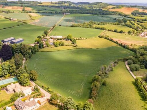 House for sale in Lot 3: Oakham Farm, Nashs Lane, Ebrington, Gloucestershire, GL55 — £105,000 • 1 bed • 1 bath
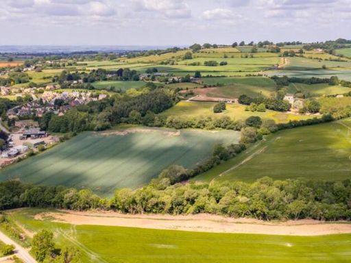 House for sale in Lot 4: Oakham Farm, Nashs Lane, Ebrington, Gloucestershire, GL55 — £220,000 • 1 bed • 1 bath
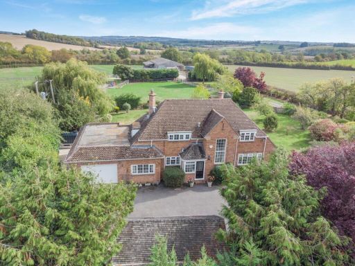 Equestrian facility for sale in Stretton On Fosse, Moreton In Marsh, Gloucestershire, GL56 — £1,500,000 • 4 bed • 2 bath • 12842 ft²
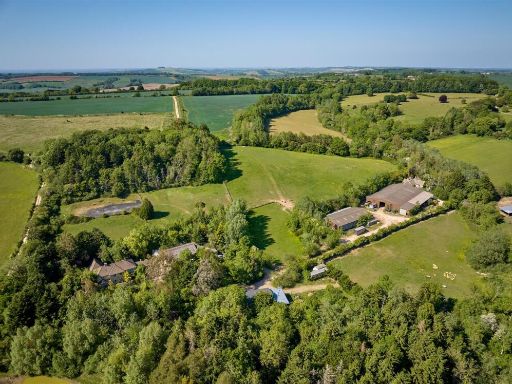 4 bedroom house for sale in Great Rollright, Oxfordshire, OX7 — £4,400,000 • 4 bed • 3 bath
Meta
- {
"@context": "https://schema.org",
"@type": "Residence",
"name": "House for sale in Lot 1: Oakham Farm, Nashs Lane, Ebrington…",
"description": "",
"url": "https://propertypiper.co.uk/property/c0ff06b9-3872-4734-bf7e-ba0be5628f3d",
"image": "https://image-a.propertypiper.co.uk/5802be28-fe89-4858-b060-0726e89f1916-1024.jpeg",
"address": {
"@type": "PostalAddress",
"streetAddress": "OAKHAM FARM, NASHS LANE, CHIPPING CAMPDEN, EBRINGTON",
"postalCode": "GL55 6NN",
"addressLocality": "Cotswold",
"addressRegion": "The Cotswolds",
"addressCountry": "England"
},
"geo": {
"@type": "GeoCoordinates",
"latitude": 52.061664,
"longitude": -1.726525
},
"numberOfRooms": 1,
"numberOfBathroomsTotal": 1,
"offers": {
"@type": "Offer",
"price": 2000000,
"priceCurrency": "GBP",
"availability": "https://schema.org/InStock"
},
"additionalProperty": [
{
"@type": "PropertyValue",
"name": "Feature",
"value": "detached house"
},
{
"@type": "PropertyValue",
"name": "Feature",
"value": "Mid-20th Century"
},
{
"@type": "PropertyValue",
"name": "Feature",
"value": "overgrown vegetation"
},
{
"@type": "PropertyValue",
"name": "Feature",
"value": "potential curb appeal"
},
{
"@type": "PropertyValue",
"name": "Feature",
"value": "renovation opportunity"
},
{
"@type": "PropertyValue",
"name": "Feature",
"value": "off-street parking"
},
{
"@type": "PropertyValue",
"name": "Feature",
"value": "rural setting"
},
{
"@type": "PropertyValue",
"name": "Feature",
"value": "country property"
},
{
"@type": "PropertyValue",
"name": "Feature",
"value": "rural house"
},
{
"@type": "PropertyValue",
"name": "Feature",
"value": "detached"
},
{
"@type": "PropertyValue",
"name": "Feature",
"value": "countryside setting"
},
{
"@type": "PropertyValue",
"name": "Feature",
"value": "secluded"
},
{
"@type": "PropertyValue",
"name": "Feature",
"value": "nature"
},
{
"@type": "PropertyValue",
"name": "Feature",
"value": "land"
},
{
"@type": "PropertyValue",
"name": "Feature",
"value": "trees"
},
{
"@type": "PropertyValue",
"name": "Feature",
"value": "privacy"
},
{
"@type": "PropertyValue",
"name": "Feature",
"value": "renovation potential"
}
]
}