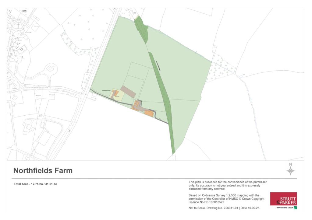
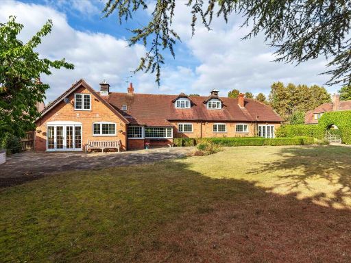
GL56 9RE - Equestrian facility for sale in Stretton On Fosse, Moreton…
View on Property Piper
Equestrian facility for sale in Stretton On Fosse, Moreton In Marsh, Gloucestershire, GL56
Property Details
- Price: £1500000
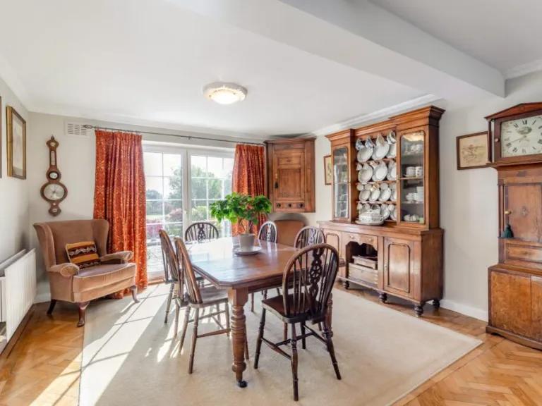
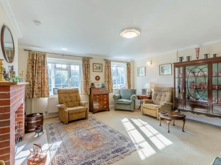
- Bedrooms: 4
- Bathrooms: 2
- Property Type: undefined
- Property SubType: undefined
Image Descriptions
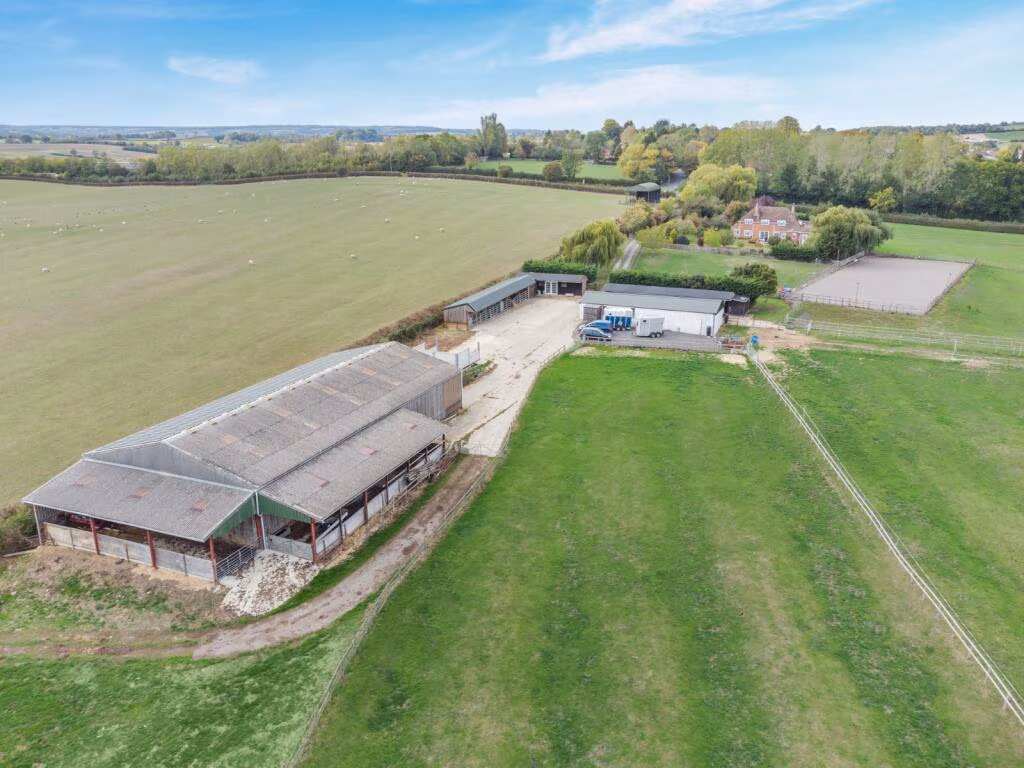
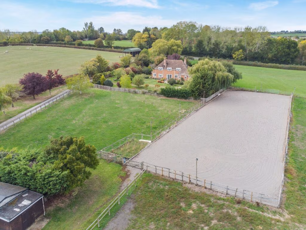
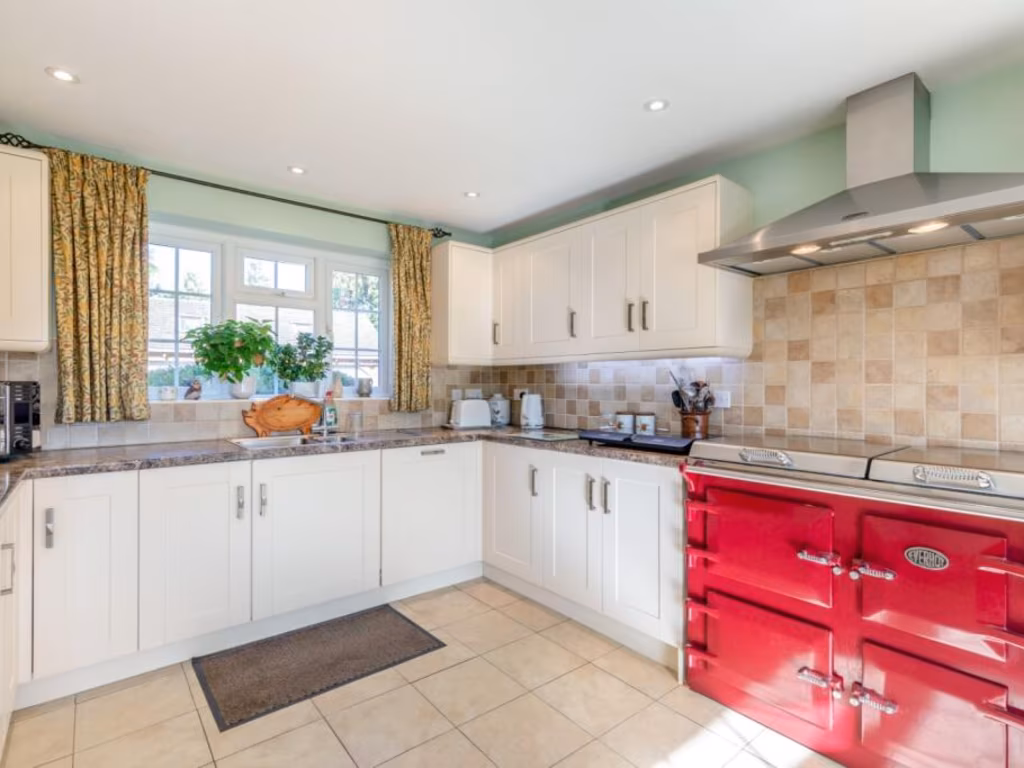
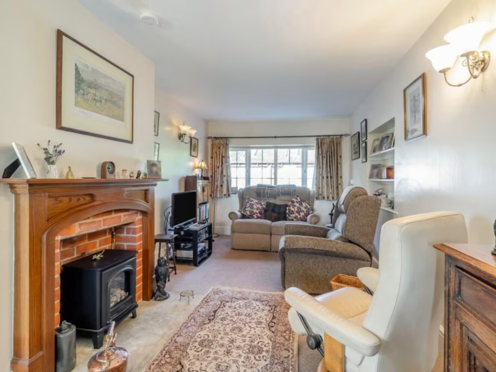
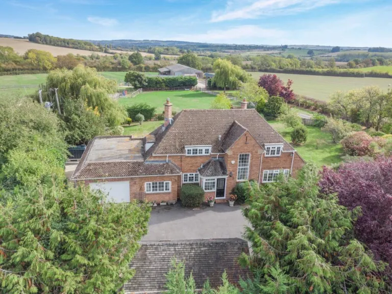
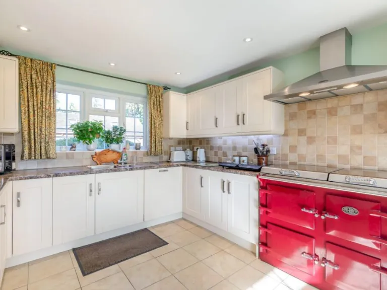
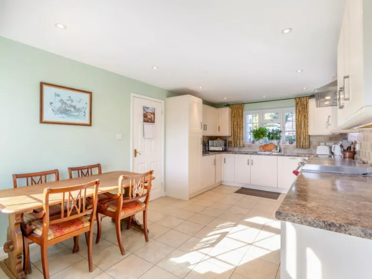
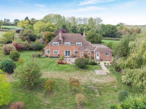
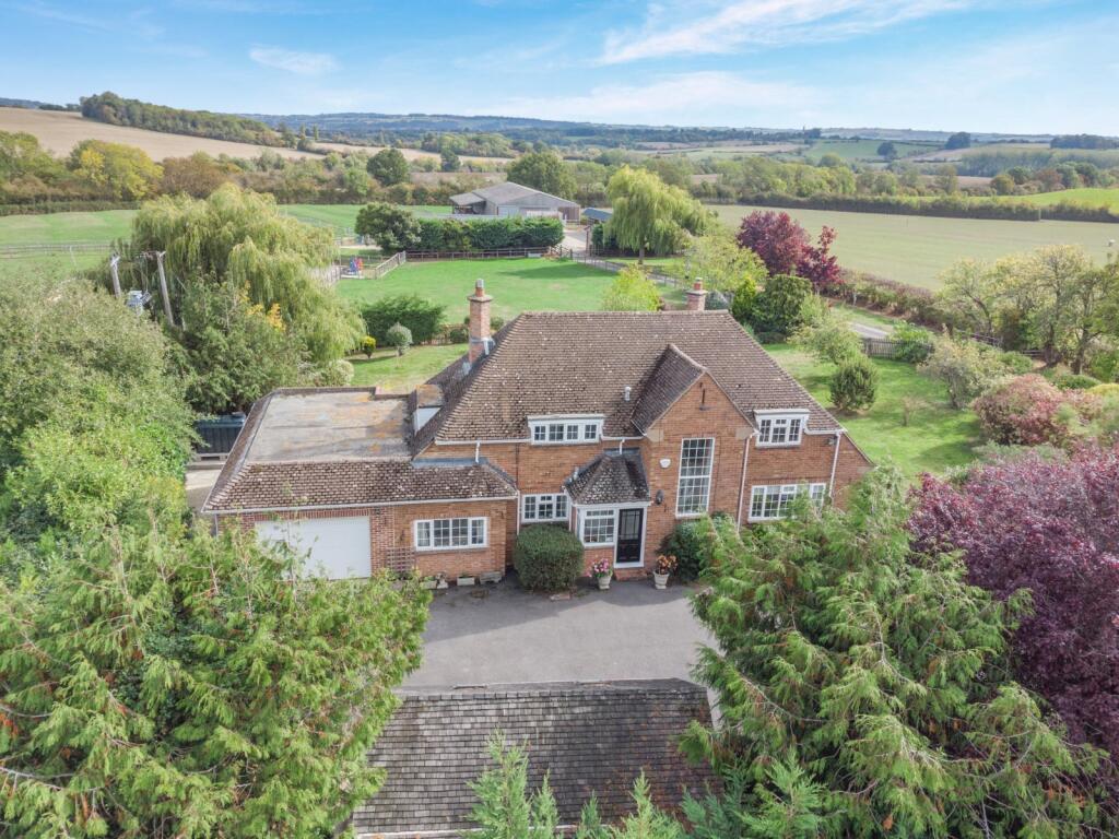
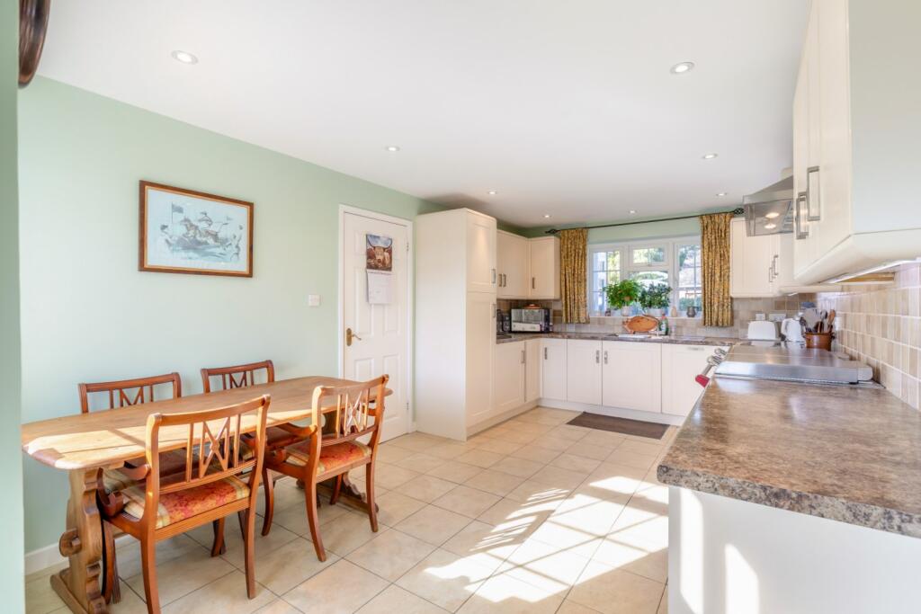
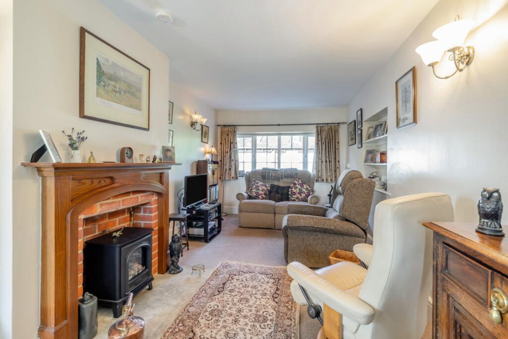
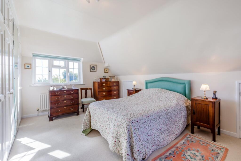
- country house modern country
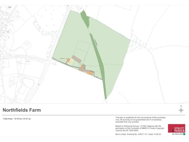
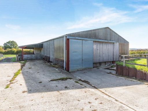
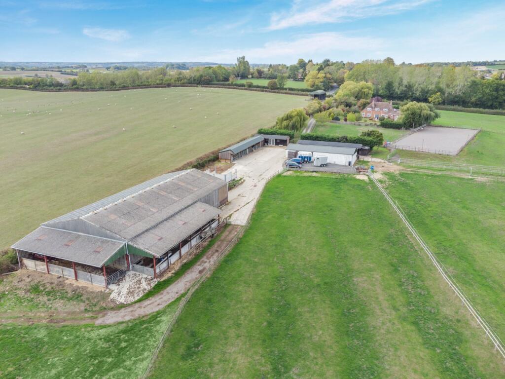
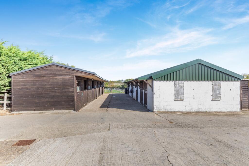
- farm property agricultural
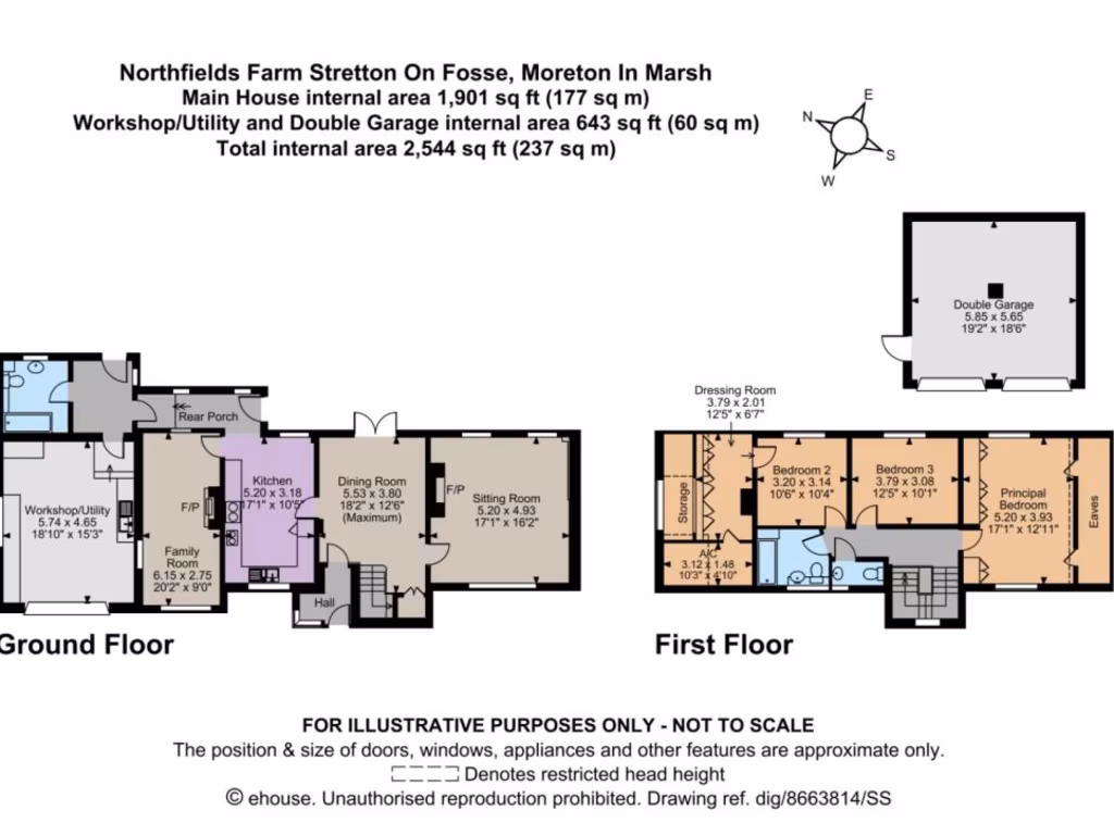
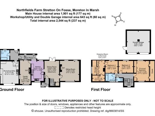
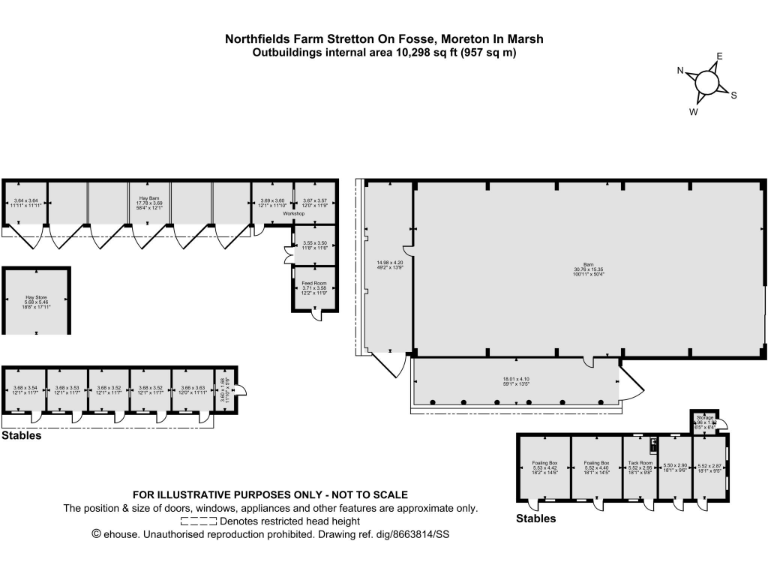
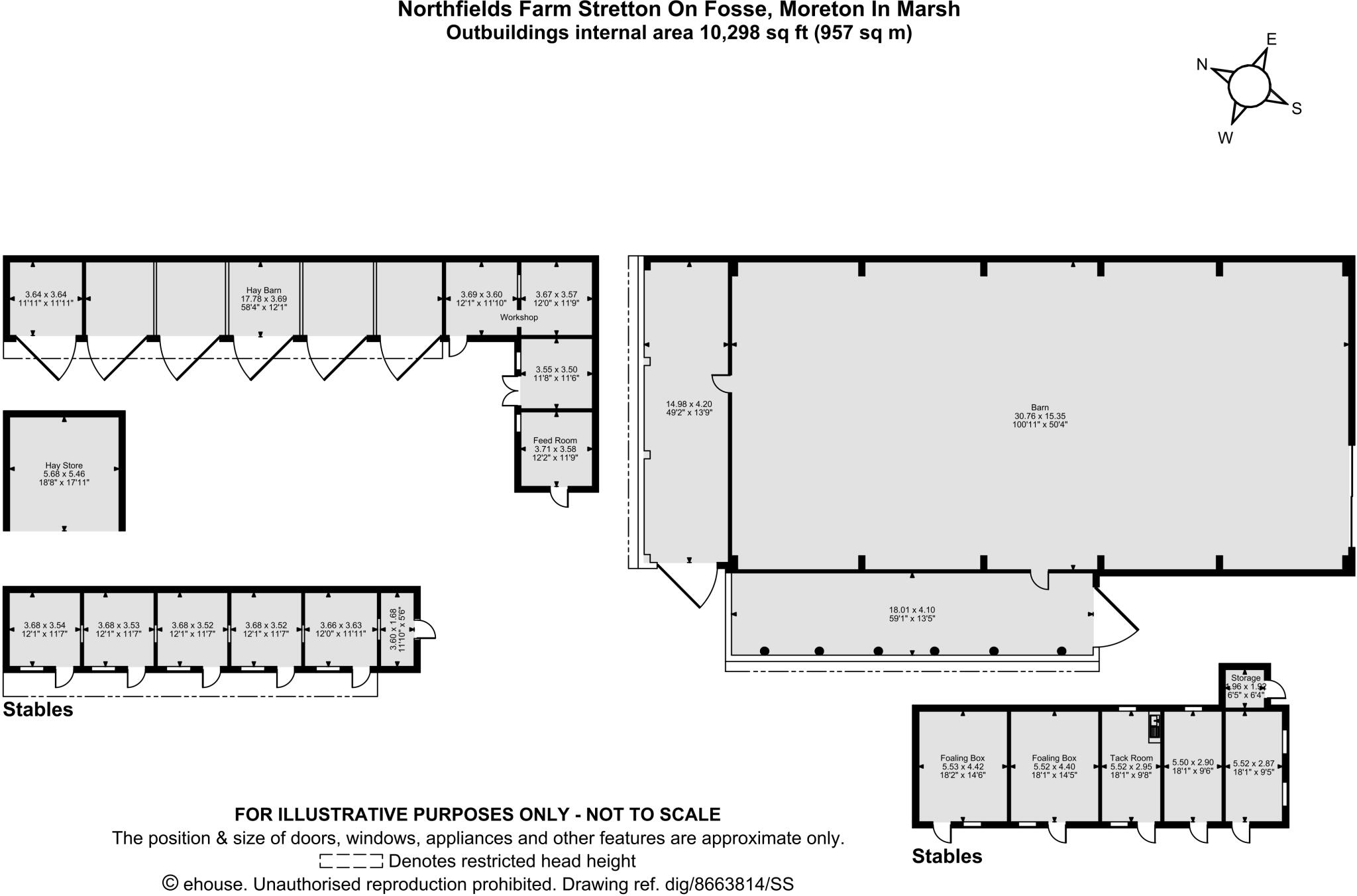
Floorplan Description
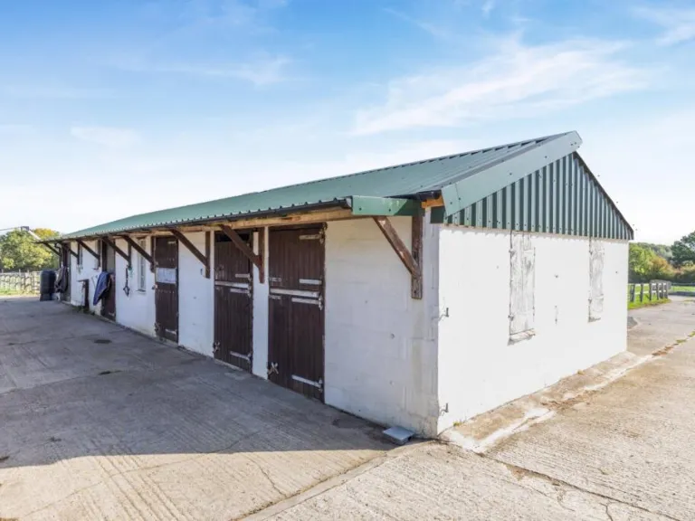
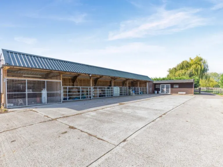
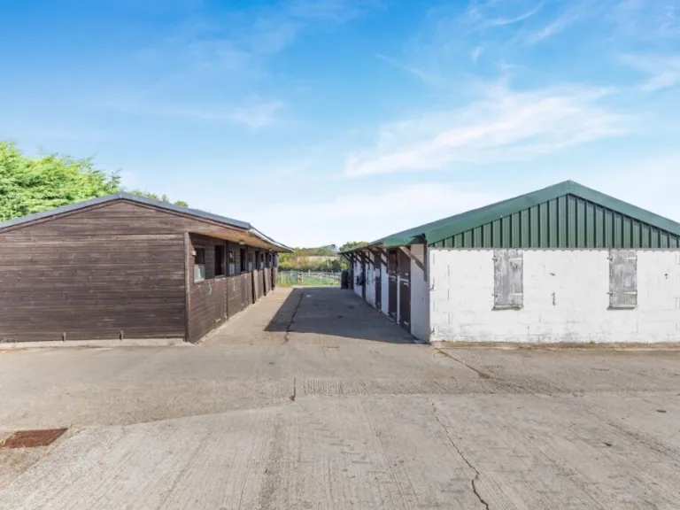
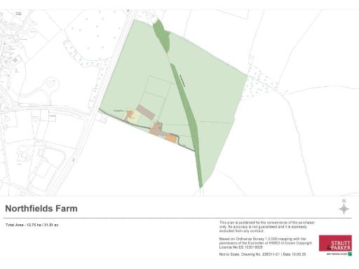
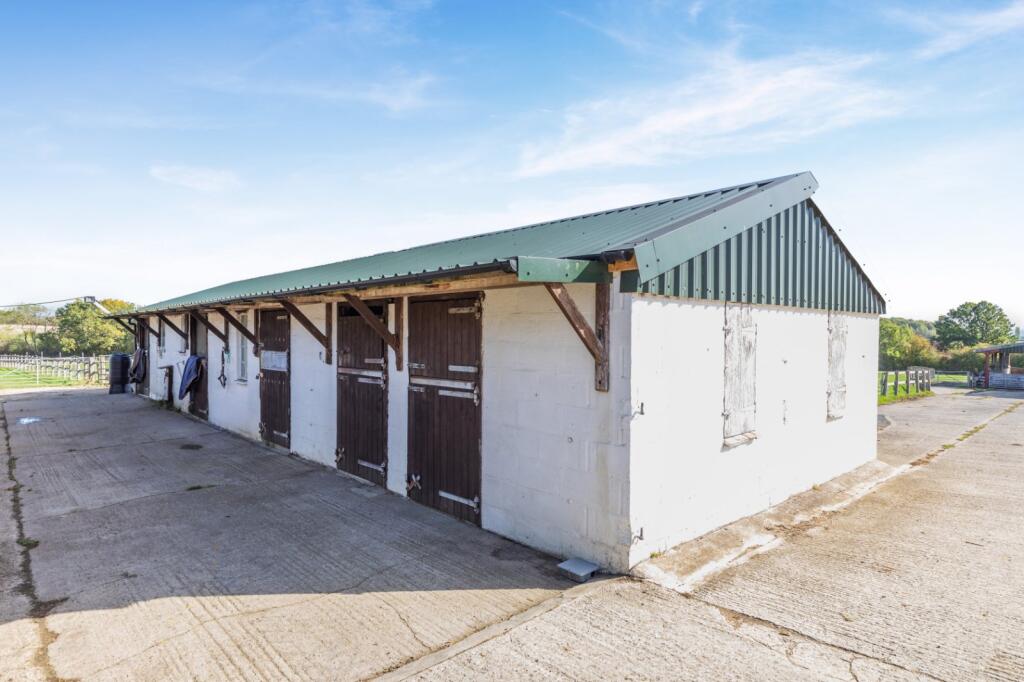
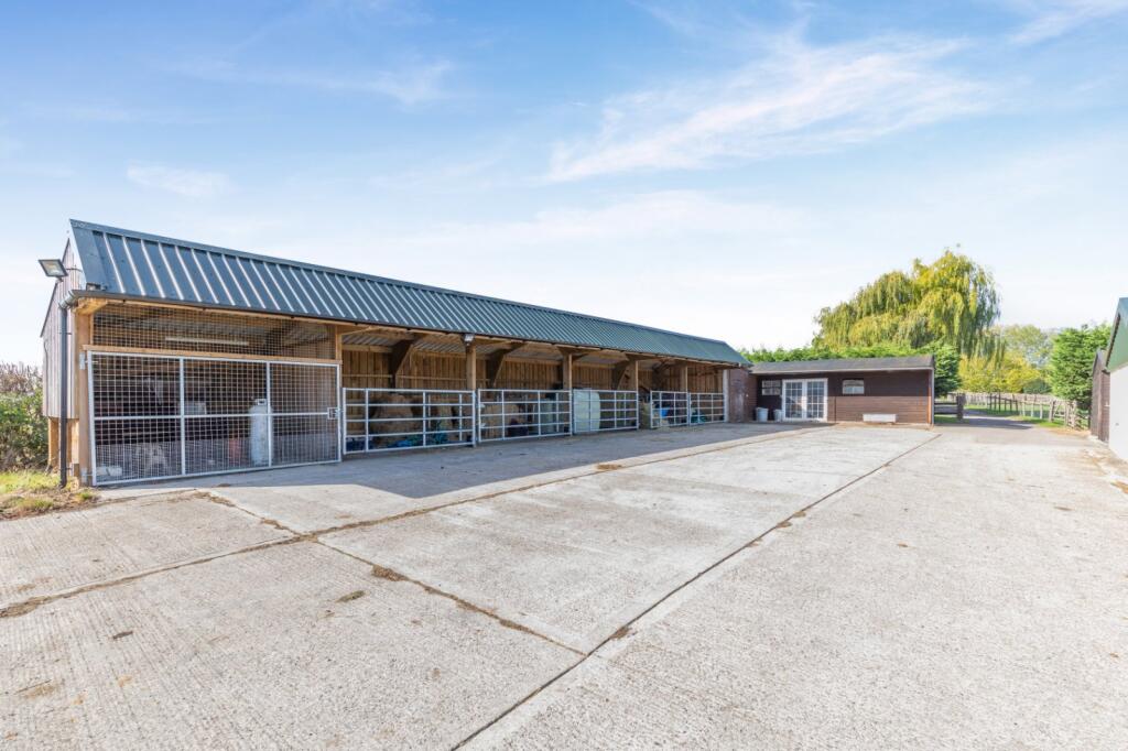
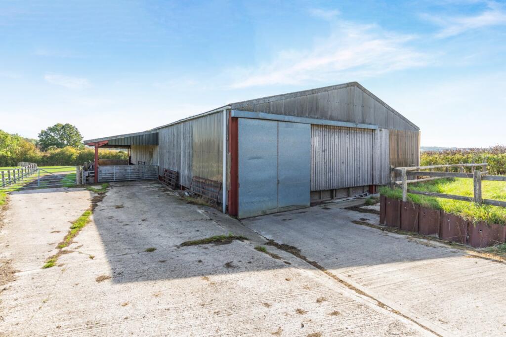
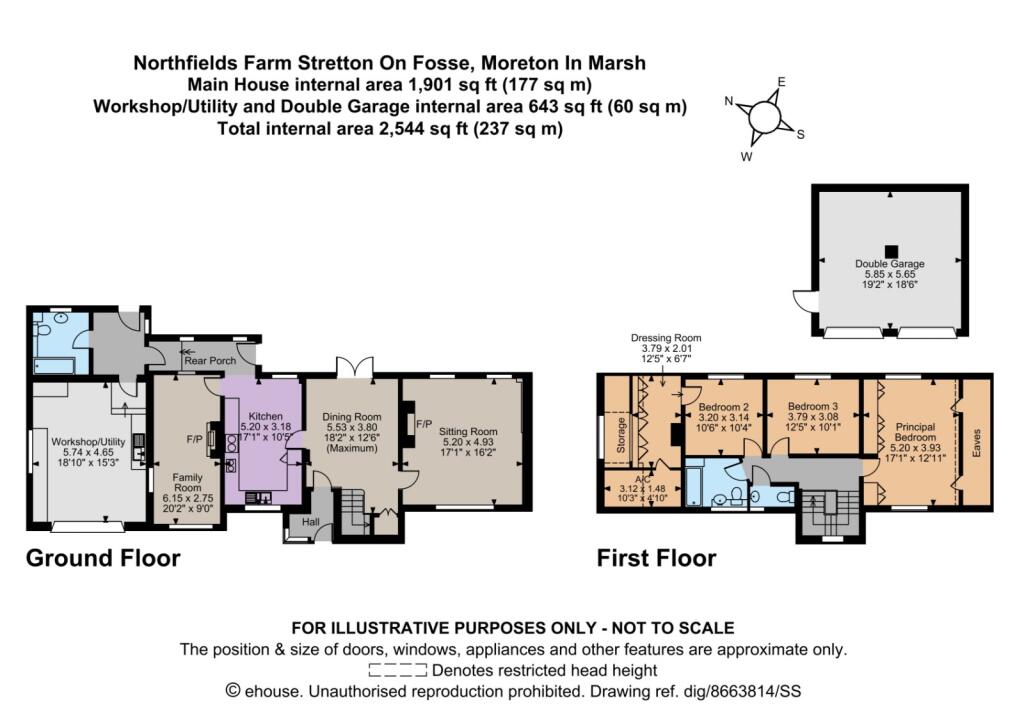
- Collection of outbuildings including a large barn, hay barns, workshops, stables and storage (single ground floor).
Rooms
- Barn: very large
- (unnamed) 14.98 x 4.20: large
- (unnamed) 18.01 x 4.10: large
- Hay Barn: large
- Hay Store: medium
- Workshop (3.69 x 3.60): small
- Workshop (3.67 x 3.57): small
- Feed Room: small
- Room 3.64 x 3.64: small
- Stable 1: small
- Stable 2: small
- Stable 3: small
- Stable 4: small
- Stable 5: small
- Foaling Box: medium
- Foaling Box: medium
- Tack Room: small
- Room 5.50 x 2.90: small
- Room 5.52 x 2.87: small
- Storage: small
Textual Property Features
Detected Visual Features
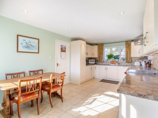
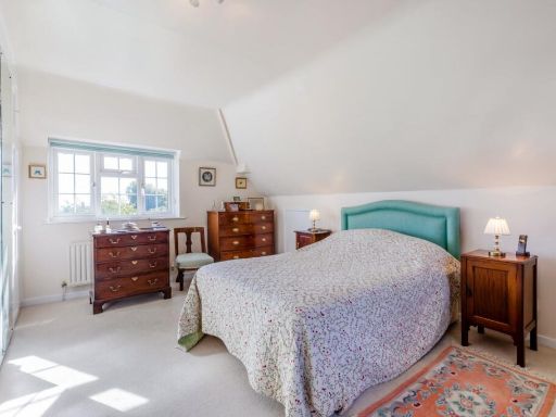
- country house
- detached
- brick exterior
- pitched roof
- driveway
- garage
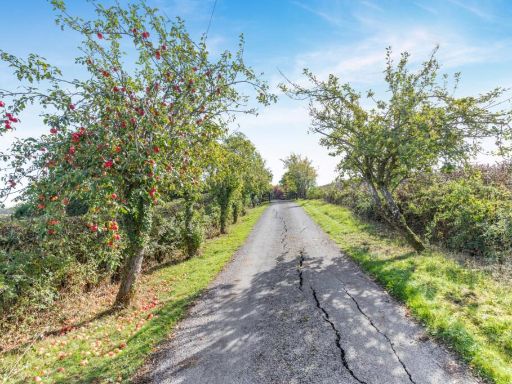
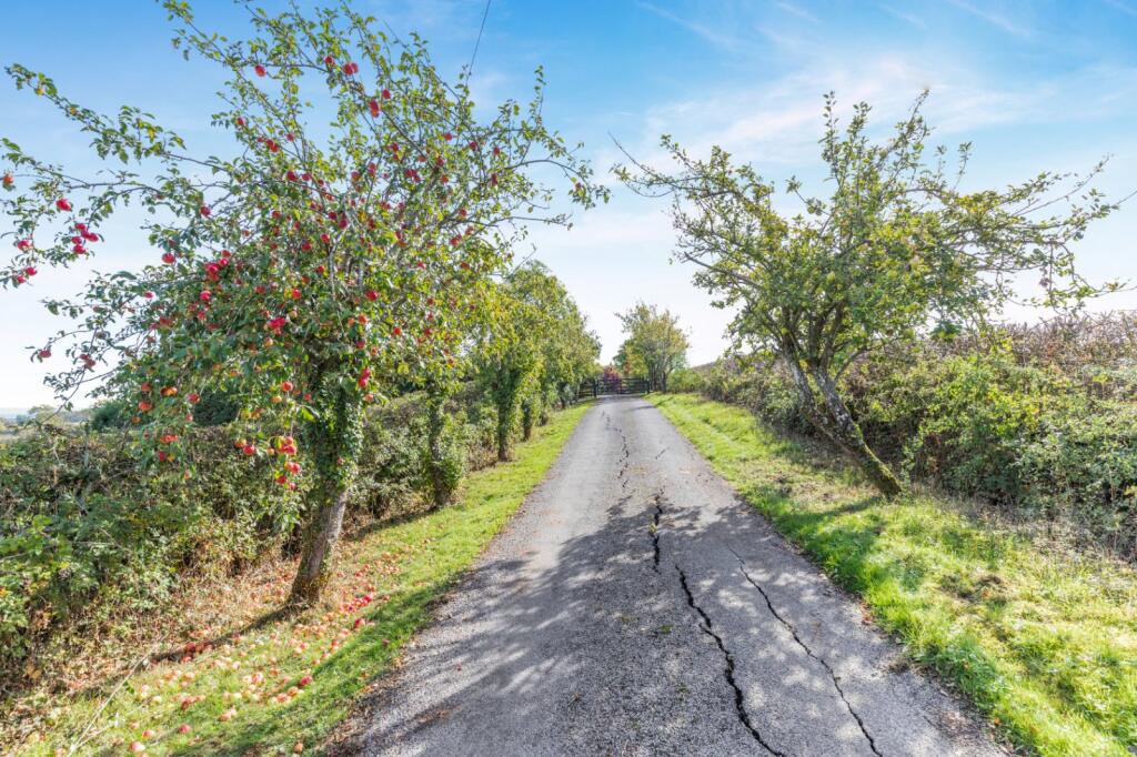
- landscape views
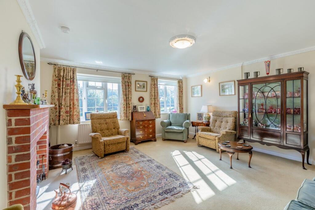
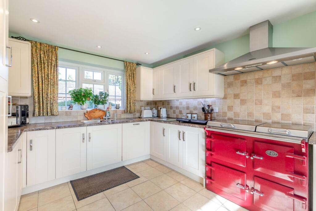
- spacious
- garden
- barns
- agricultural
- farm
- outbuildings
- rural
- land
- open space
- large plot
- horses
- livestock
- country setting
EPC Details
- Fully double glazed
- Solid brick, as built, no insulation (assumed)
- Boiler and radiators, LPG
- Low energy lighting in 60% of fixed outlets
- Solid, no insulation (assumed)
Nearby Schools
- Shipston-on-Stour Primary School
- Acorns Primary School
- Blockley Church of England Primary School
- Shipston High School
- Ilmington CofE Primary School
- St David's Church of England Primary School
- St James and Ebrington Church of England Primary School
- Chipping Campden School
- Newbold and Tredington CofE Primary School
- Mickleton Primary School
- Kitebrook Preparatory School
Nearest Bars And Restaurants
- Id: 598646679
- Tags:
- Amenity: restaurant
- Building: yes
- Cuisine: indian
- Name: Tandoori Cottage
- Source: Warwicks Aerial Imagery OGLv2
- TagsNormalized:
- Lat: 52.0624287
- Lon: -1.6241049
- FullGeoHash: gcqb5j9mes5s
- PartitionGeoHash: gcqb
- Images:
- FoodStandards: null
- Distance: 3043
,- Id: 146636515
- Tags:
- Amenity: cafe
- Building: yes
- Name: Mrs ? Tea Rooms
- Source: visual survey;bing
- TagsNormalized:
- Lat: 52.0634045
- Lon: -1.6250685
- FullGeoHash: gcqb5jbem4j1
- PartitionGeoHash: gcqb
- Images:
- FoodStandards: null
- Distance: 3030.5
,- Id: 1609414099
- Tags:
- Addr:
- Amenity: pub
- Name: Coach and Horses
- Website: http://www.hooky-pubs.co.uk/pubs/location_maps/coach_horse_ship.html
- TagsNormalized:
- Lat: 52.0617607
- Lon: -1.6243215
- FullGeoHash: gcqb5j91wxd5
- PartitionGeoHash: gcqb
- Images:
- FoodStandards: null
- Distance: 2999.4
,- Id: 153171536
- Tags:
- Addr:
- Amenity: pub
- Building: yes
- Name: The Plough Inn
- TagsNormalized:
- Lat: 52.0442848
- Lon: -1.6796513
- FullGeoHash: gcqb1f2gvmc5
- PartitionGeoHash: gcqb
- Images:
- FoodStandards: null
- Distance: 1277.3
,- Id: 10238786199
- Tags:
- Amenity: vending_machine
- Brand: Costa Coffee
- Vending: coffee
- TagsNormalized:
- vending machine
- coffee
- costa
- Lat: 52.0500388
- Lon: -1.6649023
- FullGeoHash: gcqb457tkyqz
- PartitionGeoHash: gcqb
- Images:
- FoodStandards: null
- Distance: 120.4
}
Nearest General Shops
- Id: 754723388
- Tags:
- Building: yes
- Shop: gallery
- Tourism: gallery
- TagsNormalized:
- Lat: 52.0256518
- Lon: -1.6692824
- FullGeoHash: gcnzfnbrqukv
- PartitionGeoHash: gcnz
- Images:
- FoodStandards: null
- Distance: 2848.4
,- Id: 3438522429
- Tags:
- Name: North Cotswold Brewery Shop
- Shop: alcohol
- TagsNormalized:
- Lat: 52.0495572
- Lon: -1.6531326
- FullGeoHash: gcqb47k4xhwy
- PartitionGeoHash: gcqb
- Images:
- FoodStandards: null
- Distance: 804.5
,- Id: 1611605289
- Tags:
- Addr:
- Phone: +44 1608663849
- Shop: antiques
- TagsNormalized:
- Lat: 52.0568544
- Lon: -1.6605425
- FullGeoHash: gcqb4hwv4t1b
- PartitionGeoHash: gcqb
- Images:
- FoodStandards: null
- Distance: 697.3
}
Nearest Grocery shops
- Id: 454822993
- Tags:
- Addr:
- City: Ilmington
- Postcode: CV36 4LE
- Street: Grump Street
- Building: yes
- Name: Ilmington Community Shop
- Shop: convenience
- Website: http://www.ilmingtonshop.co.uk/
- TagsNormalized:
- Lat: 52.0878036
- Lon: -1.6940077
- FullGeoHash: gcqb36q3qy27
- PartitionGeoHash: gcqb
- Images:
- FoodStandards: null
- Distance: 4547.9
,- Id: 4977437546
- Tags:
- Name: Cookies Mini-Mart
- Shop: convenience
- TagsNormalized:
- Lat: 52.0634634
- Lon: -1.6237597
- FullGeoHash: gcqb5jceetj0
- PartitionGeoHash: gcqb
- Images:
- FoodStandards: null
- Distance: 3113.5
,- Id: 598640282
- Tags:
- Brand: McColl's
- Brand:wikidata: Q16997477
- Brand:wikipedia: en:McColl's
- Building: yes
- Contact:
- Website: https://www.mccolls.co.uk/storelocator/shipston-on-stour-high-st/
- Name: McColl's
- Shop: convenience
- Source: bing
- TagsNormalized:
- Lat: 52.0631901
- Lon: -1.6251315
- FullGeoHash: gcqb5jbd5dn4
- PartitionGeoHash: gcqb
- Images:
- FoodStandards: null
- Distance: 3015.9
}
Nearest Supermarkets
- Id: 146911956
- Tags:
- Building: yes
- Name: Tesco Express
- Shop: supermarket
- Source: visual survey;bing
- TagsNormalized:
- tesco
- tesco express
- supermarket
- shop
- Lat: 52.0640923
- Lon: -1.6240261
- FullGeoHash: gcqb5jcrm6nr
- PartitionGeoHash: gcqb
- Images:
- FoodStandards: null
- Distance: 3128.8
,- Id: 146636501
- Tags:
- Addr:
- Brand: Co-op Food
- Brand:wikidata: Q3277439
- Brand:wikipedia: en:Co-op Food
- Building: yes
- Name: Co-op Food
- Operator: Co-operative Group
- Shop: supermarket
- Source: bing
- TagsNormalized:
- co-op
- co-op food
- food
- supermarket
- shop
- Lat: 52.0627106
- Lon: -1.6248674
- FullGeoHash: gcqb5j8z3bej
- PartitionGeoHash: gcqb
- Images:
- FoodStandards: null
- Distance: 3008.9
,- Id: 146636497
- Tags:
- Addr:
- Housenumber: 3-5
- Postcode: CV36 4AB
- Street: High Street
- Brand: Co-op Food
- Brand:wikidata: Q3277439
- Brand:wikipedia: en:Co-op Food
- Building: yes
- Name: Co-op Food
- Operator: Midcounties Co-operative
- Shop: supermarket
- Source: bing
- TagsNormalized:
- co-op
- co-op food
- food
- supermarket
- shop
- Lat: 52.062891
- Lon: -1.6251114
- FullGeoHash: gcqb5jb8k4m1
- PartitionGeoHash: gcqb
- Images:
- FoodStandards: null
- Distance: 3002.5
}
Nearest Religious buildings
- Id: 147770275
- Tags:
- Amenity: place_of_worship
- Building: yes
- Denomination: catholic
- Name: Our Lady and Saint Michael
- Religion: christian
- TagsNormalized:
- place of worship
- catholic
- christian
- church
- Lat: 52.0663993
- Lon: -1.6297823
- FullGeoHash: gcqb4ymhz261
- PartitionGeoHash: gcqb
- Images:
- FoodStandards: null
- Distance: 2926.7
,- Id: 251603393
- Tags:
- Amenity: place_of_worship
- Building: church
- Denomination: anglican
- Heritage: 2
- Heritage:operator: Historic England
- Listed_status: Grade II
- Name: St George
- Religion: christian
- Source: bing
- Wikidata: Q26586872
- TagsNormalized:
- place of worship
- church
- anglican
- christian
- Lat: 52.0764559
- Lon: -1.6666793
- FullGeoHash: gcqb604r7dcz
- PartitionGeoHash: gcqb
- Images:
- FoodStandards: null
- Distance: 2822.1
,- Id: 153173230
- Tags:
- Addr:
- City: Stretton on Fosse
- Postcode: GL56 9SL
- Street: Main Street
- Amenity: place_of_worship
- Building: church
- Denomination: anglican
- Name: St Peter's
- Religion: christian
- Wikidata: Q26275033
- TagsNormalized:
- place of worship
- church
- anglican
- christian
- Lat: 52.0430105
- Lon: -1.675661
- FullGeoHash: gcqb1f5ud22d
- PartitionGeoHash: gcqb
- Images:
- FoodStandards: null
- Distance: 1174.9
}
Nearest Medical buildings
- Id: 146636428
- Tags:
- Addr:
- City: Shipston-on-Stour
- Postcode: CV36 4AX
- Street: Stratford Road
- Amenity: hospital
- Fhrs:
- Healthcare: hospital
- Name: Ellen Badger Hospital
- Source: visual survey;bing
- Wikidata: Q5364743
- TagsNormalized:
- Lat: 52.0668558
- Lon: -1.6224857
- FullGeoHash: gcqb5n6x3m6u
- PartitionGeoHash: gcqb
- Images:
- FoodStandards: null
- Distance: 3371.4
,- Id: 9084068
- Tags:
- Addr:
- City: Shipston-on-Stour
- Postcode: CV36 4BQ
- Street: Badgers Crescent
- Amenity: doctors
- Building: yes
- Building:levels: 2
- Healthcare: doctor
- Name: Shipston on Stour Medical Centre
- Type: multipolygon
- Url: x
- TagsNormalized:
- doctor
- doctors
- health
- healthcare
- Lat: 52.067993
- Lon: -1.6239464
- FullGeoHash: gcqb5n9qp33u
- PartitionGeoHash: gcqb
- Images:
- FoodStandards: null
- Distance: 3355.5
,- Id: 146636493
- Tags:
- Amenity: clinic
- Building: yes
- Healthcare: clinic
- Name: Shipston Therapy Centre
- Source: bing
- TagsNormalized:
- clinic
- health
- healthcare
- therapy
- Lat: 52.0634852
- Lon: -1.6239133
- FullGeoHash: gcqb5jceb146
- PartitionGeoHash: gcqb
- Images:
- FoodStandards: null
- Distance: 3105.1
,- Id: 598414032
- Tags:
- Amenity: pharmacy
- Brand: Boots
- Brand:wikidata: Q6123139
- Brand:wikipedia: en:Boots UK
- Building: yes
- Dispensing: yes
- Healthcare: pharmacy
- Name: Boots
- Source: Bing
- TagsNormalized:
- pharmacy
- boots
- health
- healthcare
- Lat: 52.0636705
- Lon: -1.6245487
- FullGeoHash: gcqb5jchc78e
- PartitionGeoHash: gcqb
- Images:
- FoodStandards: null
- Distance: 3075.5
}
Nearest Leisure Facilities
- Id: 245646478
- Tags:
- Leisure: pitch
- Source: bing
- Sport: equestrian
- TagsNormalized:
- pitch
- leisure
- equestrian
- sports
- Lat: 52.0413556
- Lon: -1.6687106
- FullGeoHash: gcqb41bfu5z4
- PartitionGeoHash: gcqb
- Images:
- FoodStandards: null
- Distance: 1119.8
,- Id: 693079338
- Tags:
- Leisure: pitch
- Source: Warwicks CC Aerial Imagery 2013
- Sport: equestrian
- TagsNormalized:
- pitch
- leisure
- equestrian
- sports
- Lat: 52.0453317
- Lon: -1.6777808
- FullGeoHash: gcqb1fd60c5b
- PartitionGeoHash: gcqb
- Images:
- FoodStandards: null
- Distance: 1105.4
,- Id: 245646340
- Tags:
- Landuse: meadow
- Source: bing
- Sport: equestrian
- TagsNormalized:
- Lat: 52.0420925
- Lon: -1.6687093
- FullGeoHash: gcqb41bzhm0n
- PartitionGeoHash: gcqb
- Images:
- FoodStandards: null
- Distance: 1040.6
,- Id: 238739340
- Tags:
- Landuse: meadow
- Source: Warwicks CC Aerial Imagery 2013
- Sport: equestrian
- TagsNormalized:
- Lat: 52.0444643
- Lon: -1.675289
- FullGeoHash: gcqb1fkhfzmf
- PartitionGeoHash: gcqb
- Images:
- FoodStandards: null
- Distance: 1038.1
,- Id: 693079235
- Tags:
- Leisure: pitch
- Source: Warwicks CC Aerial Imagery 2013
- Sport: equestrian
- TagsNormalized:
- pitch
- leisure
- equestrian
- sports
- Lat: 52.0453752
- Lon: -1.6757725
- FullGeoHash: gcqb1fedr9jk
- PartitionGeoHash: gcqb
- Images:
- FoodStandards: null
- Distance: 993.7
}
Nearest Tourist attractions
- Id: 878857573
- Tags:
- Name: Blackwell Grange
- Source: visual survey;estimate
- Tourism: guest_house
- Wikidata: Q26275011
- TagsNormalized:
- Lat: 52.0886322
- Lon: -1.6522505
- FullGeoHash: gcqb66ky7bbd
- PartitionGeoHash: gcqb
- Images:
- FoodStandards: null
- Distance: 4257.4
,- Id: 8979325592
- Tags:
- Group_only: yes
- Name: Hardiman Fields
- Operator: Warwickshire GirlGuides
- Tourism: camp_site
- Website: https://hardimanfields.co.uk/
- TagsNormalized:
- Lat: 52.0558332
- Lon: -1.6196807
- FullGeoHash: gcqb5hkx4wws
- PartitionGeoHash: gcqb
- Images:
- FoodStandards: null
- Distance: 3117.7
,- Id: 1611518998
- Tags:
- TagsNormalized:
- Lat: 52.0319979
- Lon: -1.6784664
- FullGeoHash: gcqb1b1u2gkt
- PartitionGeoHash: gcqb
- Images:
- FoodStandards: null
- Distance: 2326.3
}
Nearest Train stations
- Id: 6609023834
- Tags:
- Name: Kingham
- Naptan:
- Network: National Rail
- Operator: GWR
- Public_transport: station
- Railway: station
- Ref:
- Wikidata: Q2183686
- Wikipedia: en:Kingham railway station
- TagsNormalized:
- Lat: 51.9024116
- Lon: -1.628532
- FullGeoHash: gcnz6bw1kqy9
- PartitionGeoHash: gcnz
- Images:
- FoodStandards: null
- Distance: 16718
,- Id: 31554736
- Tags:
- Name: Stratford-upon-Avon
- Naptan:
- Network: National Rail
- Public_transport: station
- Railway: station
- Ref:
- Wheelchair: yes
- Wikidata: Q1941516
- Wikipedia: en:Stratford-upon-Avon railway station
- TagsNormalized:
- Lat: 52.1944695
- Lon: -1.7163221
- FullGeoHash: gcqbbvwnyf36
- PartitionGeoHash: gcqb
- Images:
- FoodStandards: null
- Distance: 16327.2
,- Id: 5384060504
- Tags:
- Name: Broadway
- Operator: Gloucestershire Warwickshire Railway
- Public_transport: station
- Railway: station
- Usage: tourism
- Wikidata: Q4972554
- TagsNormalized:
- Lat: 52.043006
- Lon: -1.8720529
- FullGeoHash: gcq8j6hu6p2p
- PartitionGeoHash: gcq8
- Images:
- FoodStandards: null
- Distance: 14213.9
,- Id: 6609023833
- Tags:
- Name: Honeybourne
- Naptan:
- Network: National Rail
- Operator: Great Western Railway
- Public_transport: station
- Railway: station
- Ref:
- Source: NPE;local knowledge
- Wikidata: Q5373459
- Wikipedia: en:Honeybourne railway station
- TagsNormalized:
- Lat: 52.1016406
- Lon: -1.8336821
- FullGeoHash: gcq8qkbf01g8
- PartitionGeoHash: gcq8
- Images:
- FoodStandards: null
- Distance: 12847.6
,- Id: 6609023831
- Tags:
- Name: Moreton-in-Marsh
- Naptan:
- Network: National Rail
- Operator: First Great Western
- Public_transport: station
- Railway: station
- Ref:
- Wikidata: Q2369749
- Wikipedia: en:Moreton-in-Marsh railway station
- TagsNormalized:
- Lat: 51.9921819
- Lon: -1.7002657
- FullGeoHash: gcnzc2cukvnj
- PartitionGeoHash: gcnz
- Images:
- FoodStandards: null
- Distance: 6991.4
}
Nearest Hotels
- Id: 598213875
- Tags:
- Addr:
- Amenity: pub
- Building: yes
- Fhrs:
- Name: The Bell Inn
- Outdoor_seating: yes
- Source: visual survey;bing
- Tourism: hotel
- Website: http://thebellinnmoreton.co.uk/
- Wikidata: Q26625767
- TagsNormalized:
- Lat: 51.9909965
- Lon: -1.7036153
- FullGeoHash: gcnzc0xmwbhq
- PartitionGeoHash: gcnz
- Images:
- FoodStandards: null
- Distance: 7196.9
,- Id: 615473536
- Tags:
- Amenity: pub
- Building: yes
- Name: The Halford Bridge(closed)
- Source: Warwicks CC Aerial Imagery 2013
- Tourism: hotel
- Wikidata: Q26480932
- TagsNormalized:
- Lat: 52.1073081
- Lon: -1.6222318
- FullGeoHash: gcqb7jfep622
- PartitionGeoHash: gcqb
- Images:
- FoodStandards: null
- Distance: 6888
,- Id: 560774858
- Tags:
- Addr:
- City: Shipston-on-Stour
- Postcode: CV36 4AW
- Street: Mill Street
- Building: yes
- Name: The Old Mill
- Source: Warwicks CC Aerial Imagery 2013
- Tourism: hotel
- Website: http://www.theoldmillshipston.co.uk/
- TagsNormalized:
- Lat: 52.0616075
- Lon: -1.6225772
- FullGeoHash: gcqb5jd2z5n9
- PartitionGeoHash: gcqb
- Images:
- FoodStandards: null
- Distance: 3102.9
}
Tags
- country house
- detached
- brick exterior
- pitched roof
- driveway
- garage
- landscape views
- spacious
- garden
- barns
- agricultural
- farm
- outbuildings
- rural
- land
- open space
- large plot
- horses
- livestock
- country setting
Local Market Stats
- Average Price/sqft: £385
- Avg Income: £48000
- Social Housing: 10%
- Planning Success Rate: 93%
Similar Properties
 5 bedroom detached house for sale in Moreton Paddox, Moreton Morrell, Warwick, Warwickshire, CV35 — £1,350,000 • 5 bed • 3 bath • 4717 ft²
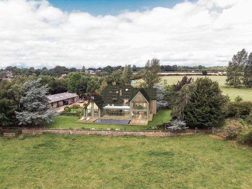 5 bedroom farm house for sale in Ratley, Banbury, Warwickshire, OX15 — £1,800,000 • 5 bed • 5 bath • 5309 ft²
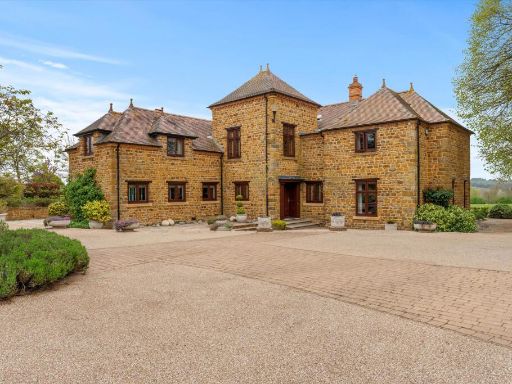 4 bedroom detached house for sale in Fawsley Road, Fawsley, Daventry, Northamptonshire, NN11 — £2,950,000 • 4 bed • 3 bath • 8657 ft²
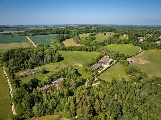 6 bedroom country house for sale in Great Rollright, Oxfordshire, OX7 — £6,500,000 • 6 bed • 3 bath • 6839 ft²
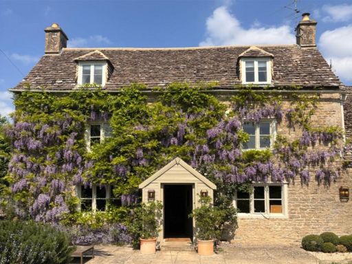 5 bedroom country house for sale in Shorncote, Cirencester, GL7 — £1,595,000 • 5 bed • 3 bath • 3021 ft²
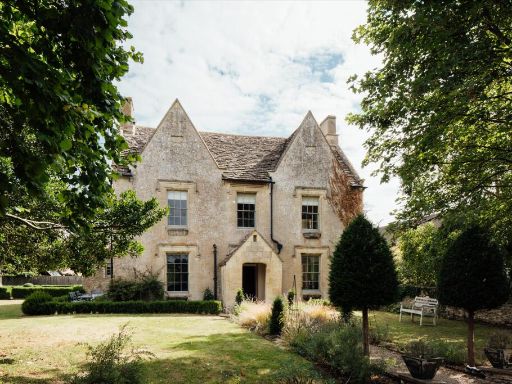 5 bedroom detached house for sale in Burford Road, Lechlade, Gloucestershire, GL7 — £1,950,000 • 5 bed • 5 bath • 3717 ft²
Meta
- {
"@context": "https://schema.org",
"@type": "Residence",
"name": "Equestrian facility for sale in Stretton On Fosse, Moreton…",
"description": "",
"url": "https://propertypiper.co.uk/property/00f0ca17-af47-406b-b934-885baf219f3d",
"image": "https://image-a.propertypiper.co.uk/dd59a41b-97aa-4c3e-b7f7-8119f6aab5ff-1024.jpeg",
"address": {
"@type": "PostalAddress",
"streetAddress": "Rowborough Cottage, Stretton on Fosse",
"postalCode": "GL56 9RE",
"addressLocality": "Stratford-on-Avon",
"addressRegion": "Stratford-on-Avon",
"addressCountry": "England"
},
"geo": {
"@type": "GeoCoordinates",
"latitude": 52.051107663310866,
"longitude": -1.6646241994440518
},
"numberOfRooms": 4,
"numberOfBathroomsTotal": 2,
"floorSize": {
"@type": "QuantitativeValue",
"value": 12842,
"unitCode": "FTK"
},
"offers": {
"@type": "Offer",
"price": 1500000,
"priceCurrency": "GBP",
"availability": "https://schema.org/InStock"
},
"additionalProperty": [
{
"@type": "PropertyValue",
"name": "Feature",
"value": "country house"
},
{
"@type": "PropertyValue",
"name": "Feature",
"value": "detached"
},
{
"@type": "PropertyValue",
"name": "Feature",
"value": "brick exterior"
},
{
"@type": "PropertyValue",
"name": "Feature",
"value": "pitched roof"
},
{
"@type": "PropertyValue",
"name": "Feature",
"value": "driveway"
},
{
"@type": "PropertyValue",
"name": "Feature",
"value": "garage"
},
{
"@type": "PropertyValue",
"name": "Feature",
"value": "landscape views"
},
{
"@type": "PropertyValue",
"name": "Feature",
"value": "spacious"
},
{
"@type": "PropertyValue",
"name": "Feature",
"value": "garden"
},
{
"@type": "PropertyValue",
"name": "Feature",
"value": "barns"
},
{
"@type": "PropertyValue",
"name": "Feature",
"value": "agricultural"
},
{
"@type": "PropertyValue",
"name": "Feature",
"value": "farm"
},
{
"@type": "PropertyValue",
"name": "Feature",
"value": "outbuildings"
},
{
"@type": "PropertyValue",
"name": "Feature",
"value": "rural"
},
{
"@type": "PropertyValue",
"name": "Feature",
"value": "land"
},
{
"@type": "PropertyValue",
"name": "Feature",
"value": "open space"
},
{
"@type": "PropertyValue",
"name": "Feature",
"value": "large plot"
},
{
"@type": "PropertyValue",
"name": "Feature",
"value": "horses"
},
{
"@type": "PropertyValue",
"name": "Feature",
"value": "livestock"
},
{
"@type": "PropertyValue",
"name": "Feature",
"value": "country setting"
}
]
}
High Res Floorplan Images
Compatible Floorplan Images
FloorplanImages Thumbnail