NN6 6HJ - Land for sale in Land off South Kilworth Road, Welford, NN6
View on Property Piper
Land for sale in Land off South Kilworth Road, Welford, NN6
Property Details
- Price: £325000
- Bedrooms: 1
- Bathrooms: 1
- Property Type: undefined
- Property SubType: undefined
Brochure Descriptions
- Period red-brick farmhouse/cottage (end-of-terrace/semidetached in appearance) presented over two storeys with traditional proportions. The property has a symmetrical front elevation with multiple recessed sash-style windows, a central entrance with a small porch canopy, two chimneys and an attached single garage to the side. A vehicular drive runs alongside the property providing off-street parking and access to what appears to be substantial private gardens to the rear with open countryside beyond — attractive rural outlooks visible from the side/rear. Construction and styling suggest a historic building refurbished to retain character. Overall accommodation likely to be medium-to-large for a village dwelling (multiple ground and first-floor rooms), with garden size large (suitable for family use, potential to extend subject to consent) and limited on-street frontage. Valuator comments: desirable village location, strong kerb appeal, good plot depth with countryside views which typically add a premium; the presence of a garage and private drive improves utility and marketability. Condition appears good externally, but an internal inspection would be required to confirm layout, floor area and any conversion/modernisation needs.
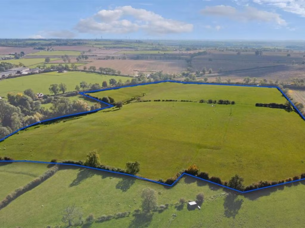
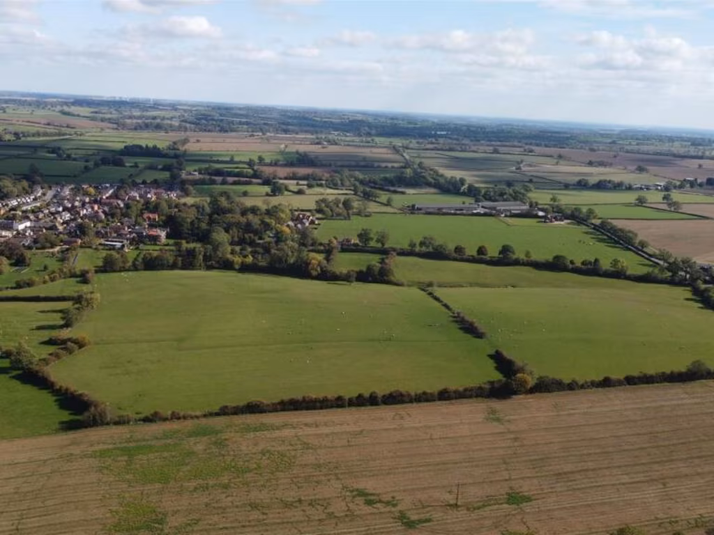
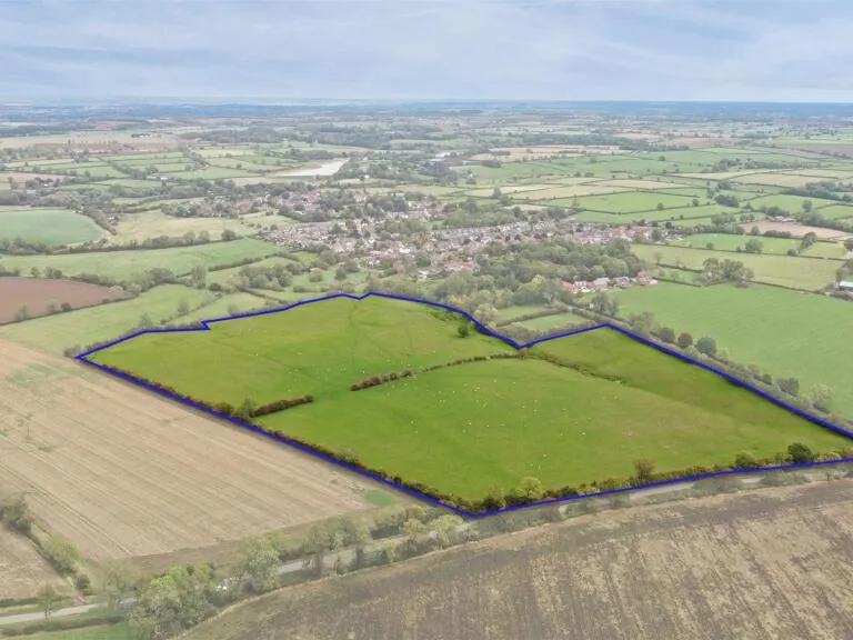
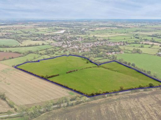
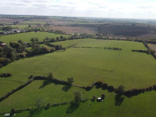
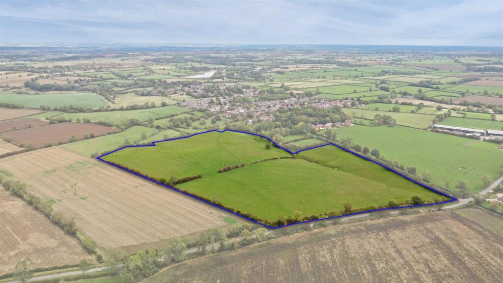
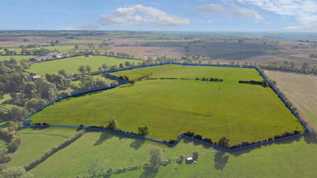
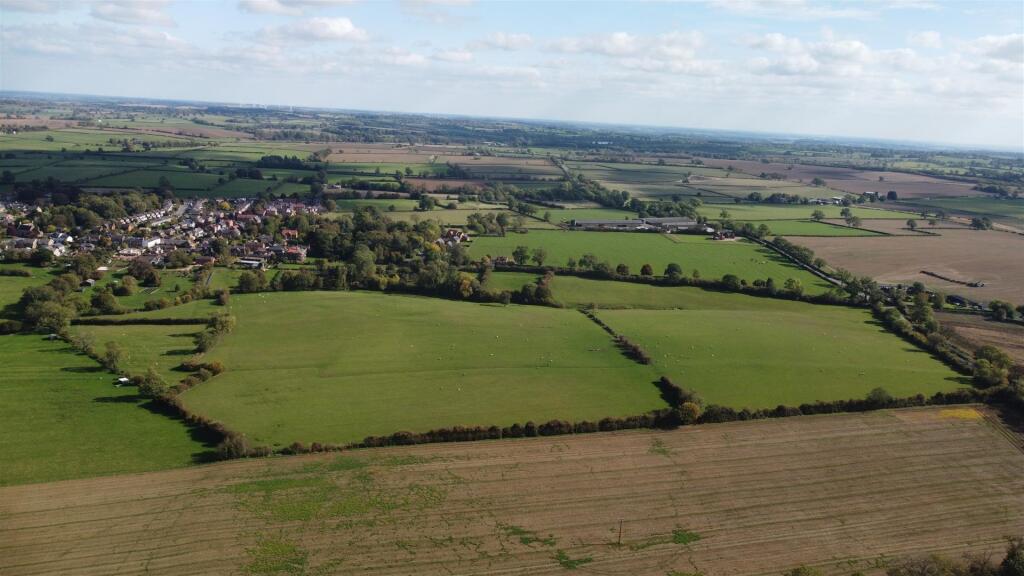
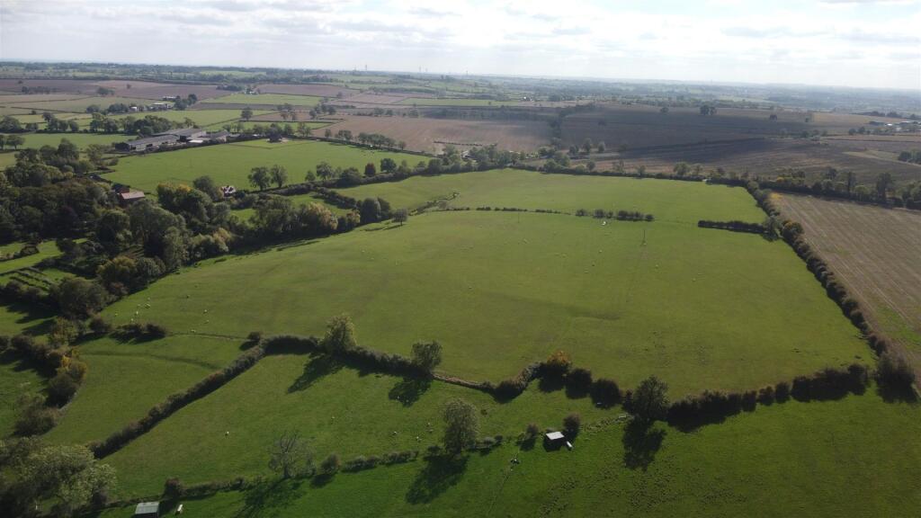
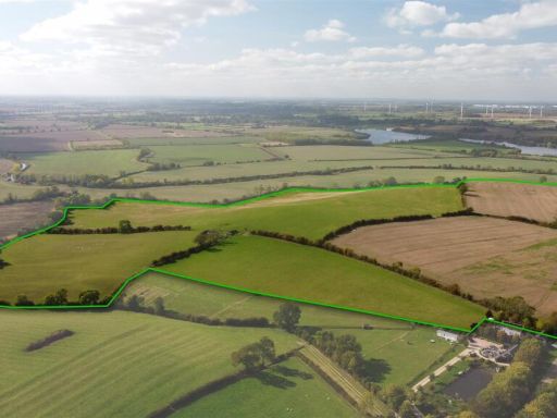
- Agricultural pasture land offered in multiple lots (three What3Words locations supplied). Rural property within the Northampton/Rugby area depicted on the location map. The holding appears to be open grazing fields bounded by hedgerows and field boundaries with typical access from country lanes or tracks. Suitable for livestock/agricultural use; no residential building address is shown on the images. Size cannot be determined from the images; impression is medium-to-large scale farmland with extensive countryside views and good local road connections to Rugby/Northampton. Please note viewers are asked to keep gates closed and observe biosecurity (livestock grazing).
Image Descriptions
- green field with potential development opportunity
- agricultural land open field
Floorplan Description
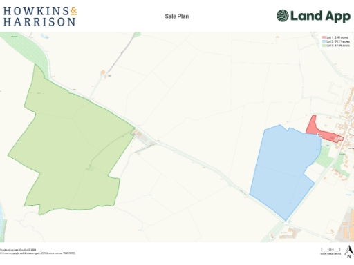
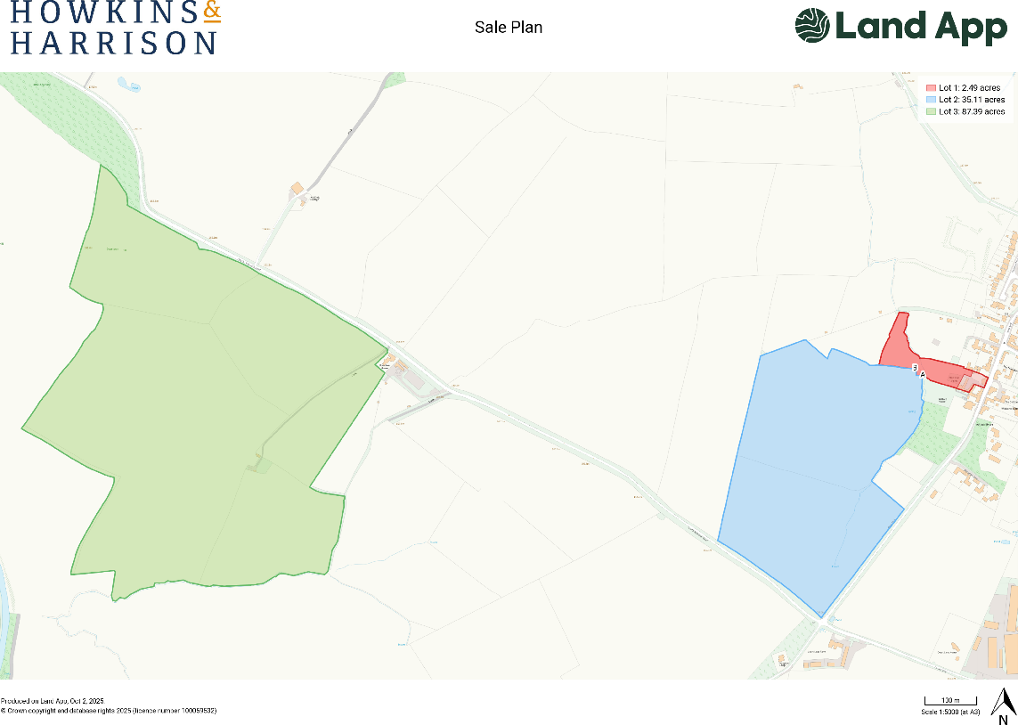
- Sale plan map showing three lots with areas labelled: Lot 1 2.49 acres (red), Lot 2 35.11 acres (blue), Lot 3 87.39 acres (green).
Textual Property Features
Detected Visual Features
- land
- greenfield
- development opportunity
- rural setting
- agricultural use
- investment opportunity
- potential for development
- farm land
- open space
- countryside
- agricultural land
- open field
- pasture
- rural
- expansive acreage
- farmland
- undeveloped land
EPC Details
- Mostly double glazing
- Solid brick, as built, no insulation (assumed)
- Boiler and radiators, oil
- Low energy lighting in all fixed outlets
- Solid, insulated
Nearby Schools
- South Kilworth Church of England Primary School
- Yelvertoft Primary School
- Guilsborough Church of England Primary School
- Guilsborough Academy
- Swinford Church of England Primary School
- Naseby Church of England Primary Academy
- Clipston Endowed Voluntary Controlled Primary School
- Crick Primary School
- Welford Sibbertoft and Sulby Endowed School
- St Andrew's Church of England Primary School, North Kilworth
- Husbands Bosworth Church of England Primary School
Nearest Airports
- Id: 2437117
- Tags:
- Aerodrome: international
- Aerodrome:type: public
- Aeroway: aerodrome
- Ele: 104
- Iata: BHX
- Icao: EGBB
- Internet_access: wlan
- Is_in: Birmingham,England,UK
- Name: Birmingham Airport
- Ref: BHX
- Type: multipolygon
- Website: https://www.birminghamairport.co.uk/
- Wikidata: Q8719
- Wikipedia: en:Birmingham Airport
- TagsNormalized:
- airport
- international airport
- Lat: 52.4543817
- Lon: -1.7468974
- FullGeoHash: gcqf2jpbym6y
- PartitionGeoHash: gcqf
- Images:
- FoodStandards: null
- Distance: 46554.5
}
Nearest Leisure Facilities
- Id: 929564040
- Tags:
- Leisure: pitch
- Sport: multi
- Surface: asphalt
- TagsNormalized:
- Lat: 52.4183467
- Lon: -1.0596481
- FullGeoHash: gcr4pykrh2j1
- PartitionGeoHash: gcr4
- Images:
- FoodStandards: null
- Distance: 472.9
,- Id: 472382642
- Tags:
- Addr:
- City: Northampton
- Country: GB
- Postcode: NN6 6HR
- Street: Newlands Road
- Village: Welford
- Building: yes
- Fhrs:
- Authority: Daventry
- Id: 896645
- Local_authority_id: PI/000044319
- Leisure: sports_centre
- Name: Welford Sports Association
- Source: Bing
- TagsNormalized:
- sports
- sports centre
- leisure
- Lat: 52.4131347
- Lon: -1.0582667
- FullGeoHash: gcr4pvt2ss7n
- PartitionGeoHash: gcr4
- Images:
- FoodStandards:
- Id: 896645
- FHRSID: 896645
- LocalAuthorityBusinessID: PI/000044319
- BusinessName: Welford Sports Field Association
- BusinessType: Restaurant/Cafe/Canteen
- BusinessTypeID: 1
- AddressLine1: Playing Field
- AddressLine2: Pavilion
- AddressLine3: Newlands Road
- AddressLine4: Welford
- PostCode: null
- RatingValue: 4
- RatingKey: fhrs_4_en-GB
- RatingDate: 2020-03-04
- LocalAuthorityCode: 236
- LocalAuthorityName: West Northamptonshire
- LocalAuthorityWebSite: https://www.westnorthants.gov.uk
- LocalAuthorityEmailAddress: contactus@westnorthants.gov.uk
- Scores:
- Hygiene: 5
- Structural: 0
- ConfidenceInManagement: 10
- NewRatingPending: false
- Geocode:
- Longitude: -1.05822240000000
- Latitude: 52.41311130000000
- Distance: 381.1
,- Id: 404775481
- Tags:
- Leisure: park
- Name: Welford Recreational Park
- TagsNormalized:
- Lat: 52.4160496
- Lon: -1.0595442
- FullGeoHash: gcr4pyh3wgfe
- PartitionGeoHash: gcr4
- Images:
- FoodStandards: null
- Distance: 292.8
,- Id: 9701946020
- Tags:
- TagsNormalized:
- Lat: 52.416151
- Lon: -1.0600323
- FullGeoHash: gcr4pyh45qwx
- PartitionGeoHash: gcr4
- Images:
- FoodStandards: null
- Distance: 271.3
,- Id: 1055857442
- Tags:
- Leisure: pitch
- Sport: tennis
- TagsNormalized:
- Lat: 52.4158042
- Lon: -1.0602686
- FullGeoHash: gcr4py5bjyn7
- PartitionGeoHash: gcr4
- Images:
- FoodStandards: null
- Distance: 236.6
}
Nearest Tourist attractions
- Id: 940067308
- Tags:
- Addr:
- City: Sibbertoft
- Housename: Brook Meadow
- Postcode: LE16 9UJ
- Street: Welford Road
- Name: Brook Meadow
- Tourism: camp_site
- Website: https://www.brookmeadow.co.uk
- TagsNormalized:
- Lat: 52.4431174
- Lon: -1.0223988
- FullGeoHash: gcr62dzx23sh
- PartitionGeoHash: gcr6
- Images:
- FoodStandards: null
- Distance: 4201.6
,- Id: 6838714169
- Tags:
- TagsNormalized:
- Lat: 52.3831561
- Lon: -1.0507531
- FullGeoHash: gcr6004f58j9
- PartitionGeoHash: gcr6
- Images:
- FoodStandards: null
- Distance: 3609.6
,- Id: 1082820306
- Tags:
- Source: ESRI
- Surface: grass
- Tourism: caravan_site
- TagsNormalized:
- Lat: 52.4313944
- Lon: -1.0642784
- FullGeoHash: gcr4rbc5082d
- PartitionGeoHash: gcr4
- Images:
- FoodStandards: null
- Distance: 1856.7
}
Nearest Hotels
- Id: 617667744
- Tags:
- Addr:
- City: Northampton
- Country: GB
- Place: Crick
- Postcode: NN6 7XR
- Street: Rugby Road
- Brand: Holiday Inn
- Brand:wikidata: Q2717882
- Brand:wikipedia: en:Holiday Inn
- Fhrs:
- Authority: Daventry
- Id: 162346
- Local_authority_id: PI/000002778
- Internet_access: yes
- Internet_access:fee: yes
- Landuse: commercial
- Name: Holiday Inn Rugby-Northampton M1, Jct.18
- Operator: Holiday Inn
- Source: Bing
- Tourism: hotel
- TagsNormalized:
- Lat: 52.3514248
- Lon: -1.1477996
- FullGeoHash: gcr1vfk1nkft
- PartitionGeoHash: gcr1
- Images:
- FoodStandards: null
- Distance: 9079.6
,- Id: 2325448378
- Tags:
- Addr:
- Country: GB
- Postcode: LE17 6QX
- Street: Hothorpe Hall
- Village: Marston Trussell
- Fhrs:
- Authority: West Northamptonshire
- Id: 1359505
- Local_authority_id: PI/000059572
- Name: Hothorpe Hall
- Source: http://www.hothorpe.co.uk
- Tourism: hotel
- Wikidata: Q15225904
- Wikipedia: en:Hothorpe Hall
- TagsNormalized:
- Lat: 52.4597033
- Lon: -1.0162362
- FullGeoHash: gcr62vgzzvrr
- PartitionGeoHash: gcr6
- Images:
- FoodStandards: null
- Distance: 5932.4
,- Id: 302063046
- Tags:
- Addr:
- City: Lutterworth
- Country: GB
- Postcode: LE17 6JE
- Street: Lutterworth Road
- Village: North Kilworth
- Fhrs:
- Authority: Harborough
- Id: 354902
- Local_authority_id: 03/00019/HS
- Name: Kilworth House Hotel
- Tourism: hotel
- Wikidata: Q6408299
- Wikipedia: en:Kilworth House
- TagsNormalized:
- Lat: 52.4453307
- Lon: -1.1159044
- FullGeoHash: gcr4qe7kjw1r
- PartitionGeoHash: gcr4
- Images:
- FoodStandards: null
- Distance: 4933
}
Tags
- land
- greenfield
- development opportunity
- rural setting
- agricultural use
- investment opportunity
- potential for development
- farm land
- open space
- countryside
- agricultural land
- open field
- pasture
- rural
- expansive acreage
- farmland
- investment opportunity
- undeveloped land
Local Market Stats
- Average Price/sqft: £300
- Avg Income: £49200
- Rental Yield: 3.8%
- Social Housing: 8%
- Planning Success Rate: 92%
Similar Properties
 Land for sale in Land off South Kilworth Road, Welford, NN6 — £850,000 • 1 bed • 1 bath • 2134 ft²
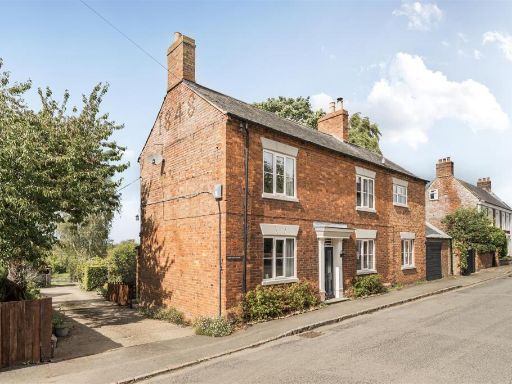 5 bedroom farm house for sale in West End, Welford, NN6 — £650,000 • 5 bed • 2 bath • 5601 ft²
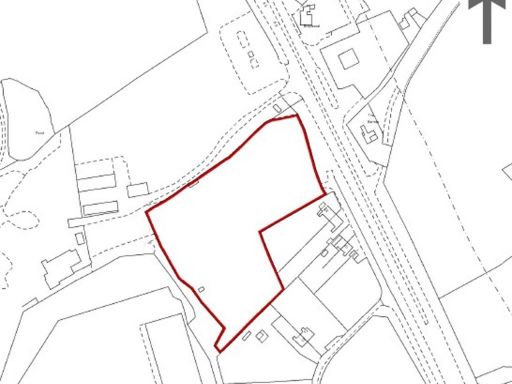 Land for sale in Land off Watling Crescent, Clifton upon Dunsmore, Rugby, CV23 0AH, CV23 — £600,000 • 1 bed • 1 bath
 4 bedroom semi-detached house for sale in Field House, Watford Court, Kilsby Road, Watford NN6 7UT, NN6 — £645,000 • 4 bed • 2 bath • 1696 ft²
 Equestrian facility for sale in West Haddon Road, Long Buckby, Northampton, Northamptonshire, NN6 — £850,000 • 4 bed • 2 bath • 1673 ft²
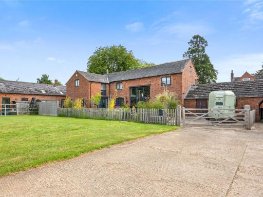 4 bedroom house for sale in West View Barn, Elkington, NN6 — £850,000 • 4 bed • 3 bath • 2324 ft²
Meta
- {
"@context": "https://schema.org",
"@type": "Residence",
"name": "Land for sale in Land off South Kilworth Road, Welford, NN6",
"description": "",
"url": "https://propertypiper.co.uk/property/be9ccd2b-fe12-4a33-9608-ccfbf7685a0a",
"image": "https://image-a.propertypiper.co.uk/aeeef6ab-2231-4b7e-acf8-d495e4913c0f-1024.jpeg",
"address": {
"@type": "PostalAddress",
"streetAddress": "5, West End, Welford",
"postalCode": "NN6 6HJ",
"addressLocality": "West Northamptonshire",
"addressRegion": "Daventry",
"addressCountry": "England"
},
"geo": {
"@type": "GeoCoordinates",
"latitude": 52.41470818320561,
"longitude": -1.0632589123331795
},
"numberOfRooms": 1,
"numberOfBathroomsTotal": 1,
"floorSize": {
"@type": "QuantitativeValue",
"value": 2134,
"unitCode": "FTK"
},
"offers": {
"@type": "Offer",
"price": 325000,
"priceCurrency": "GBP",
"availability": "https://schema.org/InStock"
},
"additionalProperty": [
{
"@type": "PropertyValue",
"name": "Feature",
"value": "land"
},
{
"@type": "PropertyValue",
"name": "Feature",
"value": "greenfield"
},
{
"@type": "PropertyValue",
"name": "Feature",
"value": "development opportunity"
},
{
"@type": "PropertyValue",
"name": "Feature",
"value": "rural setting"
},
{
"@type": "PropertyValue",
"name": "Feature",
"value": "agricultural use"
},
{
"@type": "PropertyValue",
"name": "Feature",
"value": "investment opportunity"
},
{
"@type": "PropertyValue",
"name": "Feature",
"value": "potential for development"
},
{
"@type": "PropertyValue",
"name": "Feature",
"value": "farm land"
},
{
"@type": "PropertyValue",
"name": "Feature",
"value": "open space"
},
{
"@type": "PropertyValue",
"name": "Feature",
"value": "countryside"
},
{
"@type": "PropertyValue",
"name": "Feature",
"value": "agricultural land"
},
{
"@type": "PropertyValue",
"name": "Feature",
"value": "open field"
},
{
"@type": "PropertyValue",
"name": "Feature",
"value": "pasture"
},
{
"@type": "PropertyValue",
"name": "Feature",
"value": "rural"
},
{
"@type": "PropertyValue",
"name": "Feature",
"value": "expansive acreage"
},
{
"@type": "PropertyValue",
"name": "Feature",
"value": "farmland"
},
{
"@type": "PropertyValue",
"name": "Feature",
"value": "investment opportunity"
},
{
"@type": "PropertyValue",
"name": "Feature",
"value": "undeveloped land"
}
]
}
High Res Floorplan Images
Compatible Floorplan Images
FloorplanImages Thumbnail