NG12 3UR - Land for sale in Off Fosse Way, Cotgrave, Nottingham, NG12
View on Property Piper
Land for sale in Off Fosse Way, Cotgrave, Nottingham, NG12
Property Details
- Price: £500000
- Bedrooms: 1
- Bathrooms: 1
- Property Type: undefined
- Property SubType: undefined
Brochure Descriptions
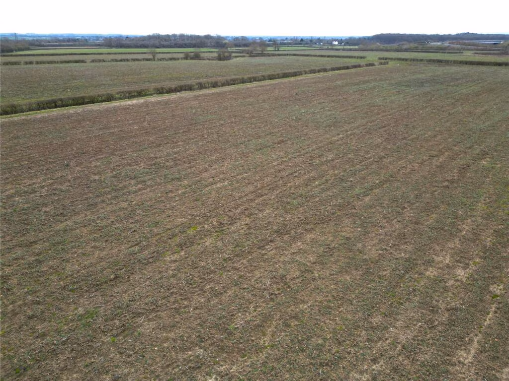
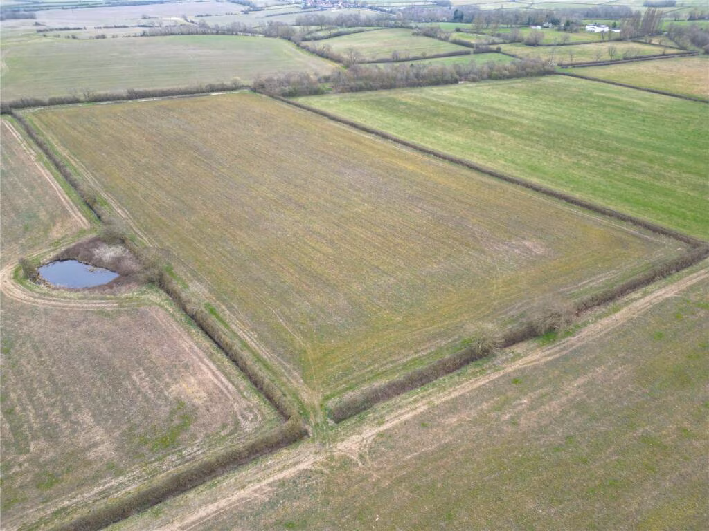
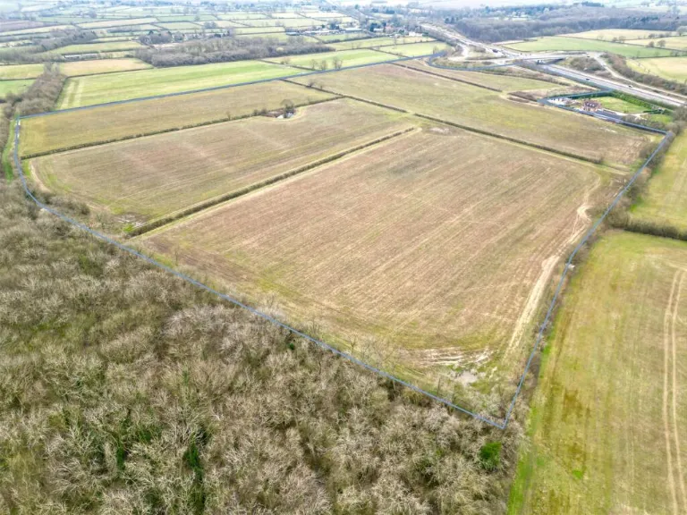
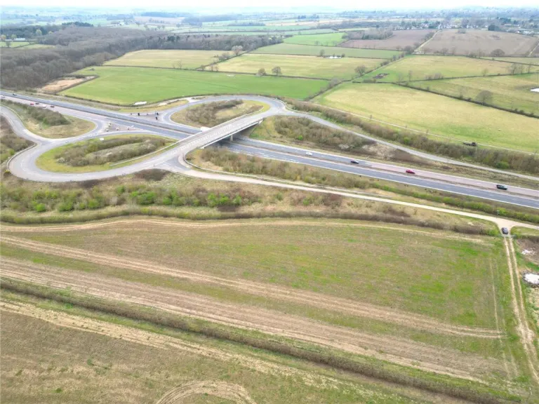
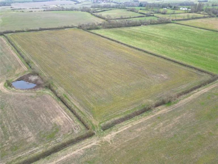
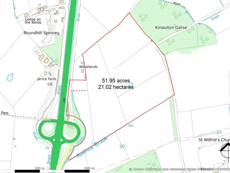
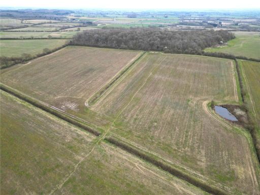
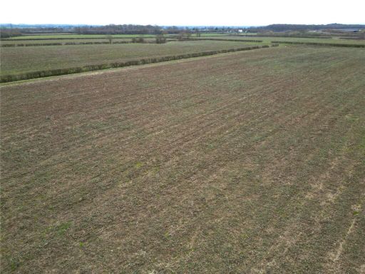
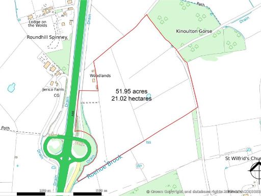
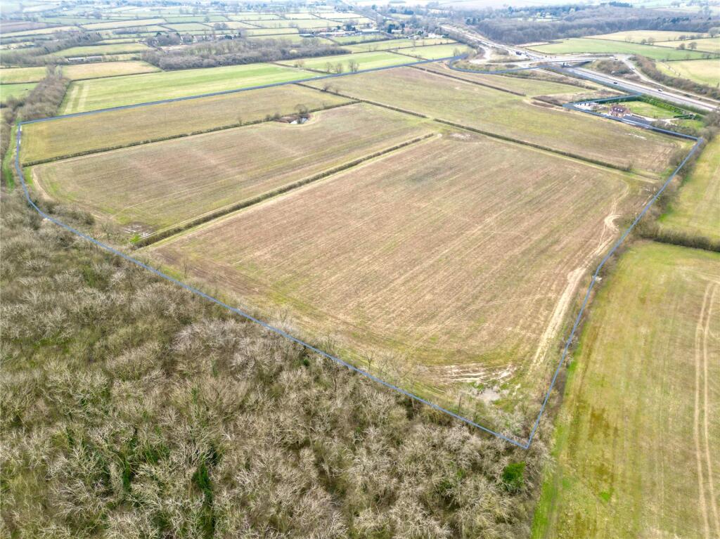
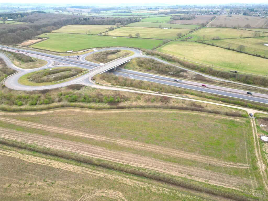
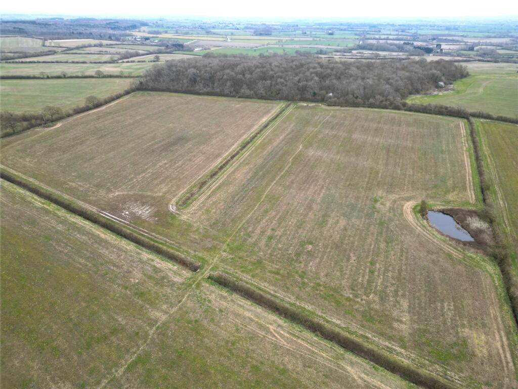
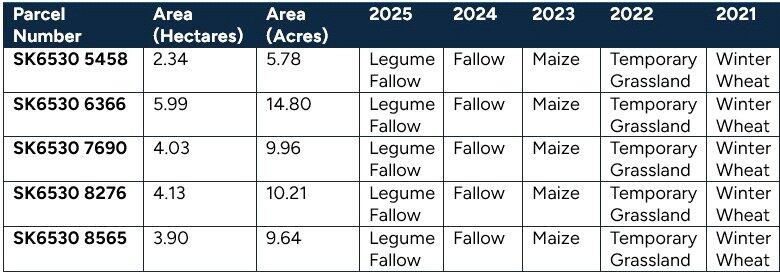
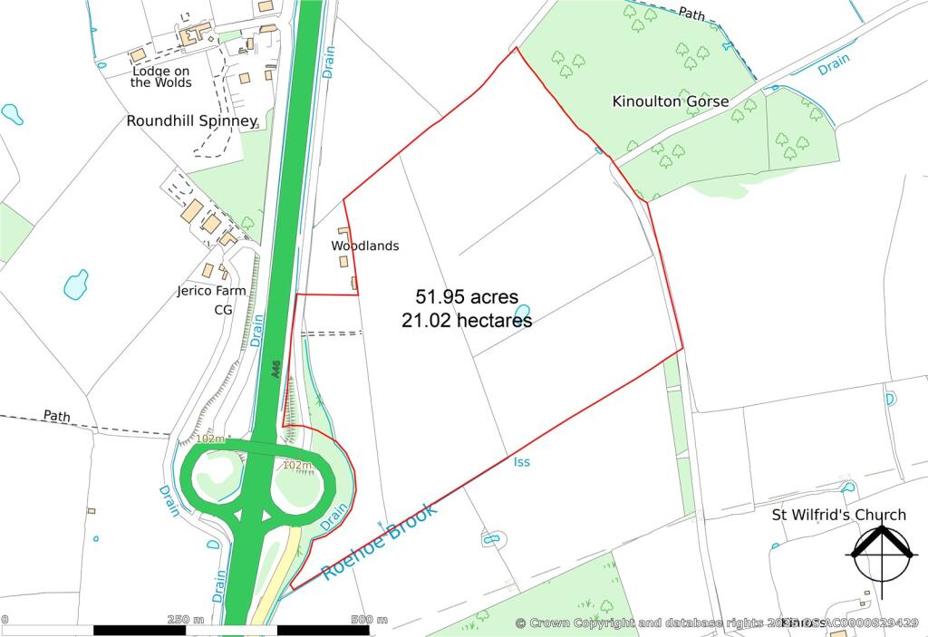
- This property consists of a substantial expanse of land totaling 51.95 acres in Cotgrave, Nottingham. The land is predominantly flat and open fields, bordered by some wooded areas. The property offers expansive views of the surrounding countryside, with fields stretching to the horizon, indicative of a large land size suitable for agricultural use or development purposes.
Image Descriptions
- farmland
- transport infrastructure modern infrastructure
Textual Property Features
Detected Visual Features
- farmland
- rural
- agricultural
- fields
- land
- bridge
- highway
- roadway
- intersection
- landscape
- modern infrastructure
Nearby Schools
- Long Clawson Church of England Primary School
- Bunny CofE Primary School
- Kinoulton Primary School
- Keyworth Primary and Nursery School
- Plumtree School
- Tollerton Primary School
- Rushcliffe Spencer Academy
- Langar CofE Primary School
- Cropwell Bishop Primary School
- Willoughby Primary School
- Willow Brook Primary School
- The South Wolds Academy & Sixth Form
- Jesse Gray Primary School
- Colston Bassett School Limited
- Wymeswold Church of England Primary School
- Crossdale Primary School
- Cotgrave Church of England Primary School
- Edwalton Primary School
- St Edmund Campion Catholic Primary School
- Old Dalby Church of England Primary School
- Rosecliffe Spencer Academy
- Cotgrave Candleby Lane School
- Pierrepont Gamston Primary School
- West Bridgford Junior School
- Abbey Road Primary School
Nearest General Shops
- Id: 4160136161
- Tags:
- Addr:
- Place: Oddhouse Farm
- Postcode: NG12 3SF
- Street: Colston Bassett Lane
- Fhrs:
- Name: The Little Retreat
- Shop: beauty
- Website: http://www.thelittleretreatdayspa.co.uk/
- TagsNormalized:
- Lat: 52.8894516
- Lon: -0.9891568
- FullGeoHash: gcrkckpxqur5
- PartitionGeoHash: gcrk
- Images:
- FoodStandards:
- Id: 730959
- FHRSID: 730959
- LocalAuthorityBusinessID: 14/00079/FOOD
- BusinessName: The Little Retreat
- BusinessType: Other catering premises
- BusinessTypeID: 7841
- AddressLine1: Oddhouse Farm
- AddressLine2: Colston Bassett Lane
- AddressLine3: Owthorpe
- AddressLine4: Nottinghamshire
- PostCode: NG12 3SF
- RatingValue: 5
- RatingKey: fhrs_5_en-GB
- RatingDate: 2022-10-19
- LocalAuthorityCode: 266
- LocalAuthorityName: Rushcliffe
- LocalAuthorityWebSite: http://www.rushcliffe.gov.uk/
- LocalAuthorityEmailAddress: envhealth@rushcliffe.gov.uk
- Scores:
- Hygiene: 0
- Structural: 5
- ConfidenceInManagement: 5
- NewRatingPending: false
- Geocode:
- Longitude: -0.98953800000000
- Latitude: 52.88930700000000
- Distance: 3346
,- Id: 3649752098
- Tags:
- Addr:
- Housename: Manor Barns
- Postcode: NG12 5BL
- Street: Browns Lane
- Name: Slaters Garage
- Shop: car_repair
- Source: survey
- Source:addr: Companies House Registered Companies
- TagsNormalized:
- garage
- car repair
- repair
- shop
- Lat: 52.8685761
- Lon: -1.0651465
- FullGeoHash: gcrhzb2mu2ch
- PartitionGeoHash: gcrh
- Images:
- FoodStandards: null
- Distance: 2523.3
,- Id: 228375087
- Tags:
- Addr:
- Housenumber: 156
- Postcode: NG12 5BQ
- Street: Melton Road
- Landuse: retail
- Name: Moores Nursery
- Shop: garden_centre
- Source:
- TagsNormalized:
- retail
- nursery
- garden centre
- shop
- Lat: 52.8715852
- Lon: -1.0518952
- FullGeoHash: gcrkb0fp31f4
- PartitionGeoHash: gcrk
- Images:
- FoodStandards: null
- Distance: 1632.2
}
Nearest Religious buildings
- Id: 39449285
- Tags:
- Addr:
- Postcode: NG12 5BB
- Street: Willow Brook
- Amenity: place_of_worship
- Building: church
- Denomination: roman_catholic
- Name: St Margaret Clitherow
- Religion: christian
- Website: http://www.eastleakeandkeyworthrcp.co.uk/
- TagsNormalized:
- place of worship
- church
- catholic
- roman catholic
- christian
- Lat: 52.8697825
- Lon: -1.0734207
- FullGeoHash: gcrhz8dkg3z9
- PartitionGeoHash: gcrh
- Images:
- FoodStandards: null
- Distance: 3071.7
,- Id: 228652245
- Tags:
- Addr:
- Amenity: place_of_worship
- Building: church
- Denomination: anglican
- Listed_status: Grade II
- Name: All Saints Parish Church
- Religion: christian
- Source:
- Listed_status: English Heritage
- Wikidata: Q15179410
- Wikipedia: en:All Saints' Church, Stanton on the Wolds
- TagsNormalized:
- place of worship
- church
- anglican
- parish
- christian
- Lat: 52.8693794
- Lon: -1.0624849
- FullGeoHash: gcrhzbd66q9u
- PartitionGeoHash: gcrh
- Images:
- FoodStandards: null
- Distance: 2339.5
,- Id: 221334078
- Tags:
- Addr:
- Postcode: NG12 3EU
- Street: Main Street
- Amenity: place_of_worship
- Building: church
- Denomination: anglican
- Name: St Luke
- Religion: christian
- Wikidata: Q15979394
- Wikipedia: en:St Luke's Church, Kinoulton
- TagsNormalized:
- place of worship
- church
- anglican
- christian
- Lat: 52.869758
- Lon: -0.9964107
- FullGeoHash: gcrkc2dktvnr
- PartitionGeoHash: gcrk
- Images:
- FoodStandards: null
- Distance: 2098.8
}
Nearest Airports
- Id: 11359528
- Tags:
- Aerodrome: international
- Aerodrome:type: public
- Aeroway: aerodrome
- Iata: EMA
- Icao: EGNX
- Is_in: Castle Donington,England,UK
- Name: East Midlands Airport
- Old_name: RAF Castle Donington
- Operator: Manchester Airports Holdings Limited
- Operator:type: private
- Ref: EMA
- Type: multipolygon
- Website: https://www.eastmidlandsairport.com/
- Wikidata: Q8977
- Wikipedia: en:East Midlands Airport
- TagsNormalized:
- airport
- international airport
- Lat: 52.8281122
- Lon: -1.3322143
- FullGeoHash: gcrh99jfj1vh
- PartitionGeoHash: gcrh
- Images:
- FoodStandards: null
- Distance: 20983.1
}
Nearest Leisure Facilities
- Id: 221322846
- Tags:
- TagsNormalized:
- Lat: 52.8627733
- Lon: -1.0236463
- FullGeoHash: gcrk8xqegr1v
- PartitionGeoHash: gcrk
- Images:
- FoodStandards: null
- Distance: 883.2
,- Id: 221322848
- Tags:
- TagsNormalized:
- Lat: 52.8629094
- Lon: -1.0230312
- FullGeoHash: gcrk8xrhc8s9
- PartitionGeoHash: gcrk
- Images:
- FoodStandards: null
- Distance: 882.5
,- Id: 221322847
- Tags:
- TagsNormalized:
- Lat: 52.8628457
- Lon: -1.0233284
- FullGeoHash: gcrk8xqu6sxj
- PartitionGeoHash: gcrk
- Images:
- FoodStandards: null
- Distance: 882.4
,- Id: 501693603
- Tags:
- TagsNormalized:
- Lat: 52.863618
- Lon: -1.0224338
- FullGeoHash: gcrk8xx2zsdh
- PartitionGeoHash: gcrk
- Images:
- FoodStandards: null
- Distance: 825.5
,- Id: 900422886
- Tags:
- TagsNormalized:
- Lat: 52.8764278
- Lon: -1.026877
- FullGeoHash: gcrkb9u78091
- PartitionGeoHash: gcrk
- Images:
- FoodStandards: null
- Distance: 679.4
}
Nearest Tourist attractions
- Id: 2400162925
- Tags:
- TagsNormalized:
- Lat: 52.8698026
- Lon: -0.9946017
- FullGeoHash: gcrkc2eubje1
- PartitionGeoHash: gcrk
- Images:
- FoodStandards: null
- Distance: 2220.1
,- Id: 7781105350
- Tags:
- Addr:
- City: Nottinghamshire
- Housename: Newfields Farm
- Postcode: NG12 3GE
- Street: Owthorpe
- Name: Woodview Holiday Accommodation
- Phone: +44 1949 81580
- Tourism: apartment
- Website: https://www.woodviewcottages.co.uk/
- TagsNormalized:
- Lat: 52.8850642
- Lon: -1.0174961
- FullGeoHash: gcrkbg7jfdeb
- PartitionGeoHash: gcrk
- Images:
- FoodStandards: null
- Distance: 1774.2
,- Id: 220593558
- Tags:
- Addr:
- Postcode: NG12 3HG
- Street: Fosse Way
- Building: house
- Guest_house: bed_and_breakfast
- Name: Jerico Farm
- Old_fhrs:
- Tourism: guest_house
- Website: https://www.jericofarm.co.uk/
- TagsNormalized:
- Lat: 52.8702271
- Lon: -1.0304522
- FullGeoHash: gcrkb89xksxj
- PartitionGeoHash: gcrk
- Images:
- FoodStandards: null
- Distance: 187.4
}
Nearest Train stations
- Id: 32671928
- Tags:
- Name: Rushcliffe Halt
- Public_transport: station
- Railway: station
- Train: yes
- Usage: tourism
- Wikidata: Q7380777
- Wikipedia: en:Rushcliffe Halt railway station
- TagsNormalized:
- Lat: 52.8438171
- Lon: -1.1822374
- FullGeoHash: gcrht5gjec7z
- PartitionGeoHash: gcrh
- Images:
- FoodStandards: null
- Distance: 10788.8
,- Id: 6414872012
- Tags:
- Name: Netherfield
- Naptan:
- Network: National Rail
- Operator: East Midlands Railway
- Postal_code: NG4 2JB
- Public_transport: station
- Railway: station
- Ref:
- Train: yes
- Wikidata: Q3308001
- Wikipedia: en:Netherfield railway station
- TagsNormalized:
- Lat: 52.9614057
- Lon: -1.0793598
- FullGeoHash: gcrjr3q491df
- PartitionGeoHash: gcrj
- Images:
- FoodStandards: null
- Distance: 10703.2
,- Id: 3170037836
- Tags:
- Name: Bingham
- Naptan:
- Network: National Rail
- Public_transport: station
- Railway: station
- Ref:
- Train: yes
- Wikidata: Q4914224
- Wikipedia: en:Bingham railway station
- TagsNormalized:
- Lat: 52.9542089
- Lon: -0.951332
- FullGeoHash: gcrm62528k52
- PartitionGeoHash: gcrm
- Images:
- FoodStandards: null
- Distance: 10638.5
,- Id: 7026744678
- Tags:
- Alt_name: Radcliffe-on-Trent
- Name: Radcliffe
- Naptan:
- Network: National Rail
- Operator: East Midlands Railway
- Public_transport: station
- Railway: station
- Ref:
- Source: NPE
- Wikidata: Q1882427
- Wikipedia: en:Radcliffe railway station
- TagsNormalized:
- Lat: 52.9487898
- Lon: -1.0369716
- FullGeoHash: gcrm0rhchccf
- PartitionGeoHash: gcrm
- Images:
- FoodStandards: null
- Distance: 8745.9
,- Id: 324257221
- Tags:
- Name: Ruddington Fields
- Public_transport: station
- Railway: station
- Train: yes
- Usage: tourism
- TagsNormalized:
- Lat: 52.8845732
- Lon: -1.1479442
- FullGeoHash: gcrhvgk4fyyz
- PartitionGeoHash: gcrh
- Images:
- FoodStandards: null
- Distance: 8225.5
}
Nearest Hotels
- Id: 71223887
- Tags:
- Addr:
- Locality: Holme Pierrepont
- Postcode: NG12 2LU
- Street: Adbolton Lane
- Amenity: events_venue
- Name: Blotts Country Club
- Not:
- Old_fhrs:
- Source:
- Addr: Food hygiene opendata
- Tourism: hotel
- Website: https://www.blotts.com/
- TagsNormalized:
- events venue
- club
- hotel
- tourism
- Lat: 52.9452244
- Lon: -1.0734832
- FullGeoHash: gcrjpw6k610v
- PartitionGeoHash: gcrj
- Images:
- FoodStandards: null
- Distance: 8875.9
,- Id: 3669369600
- Tags:
- Addr:
- Housenumber: 12
- Postcode: NG11 6LA
- Street: Easthorpe Street
- Fhrs:
- Name: The Country Cottage Hotel
- Old_fhrs:
- Source:
- Tourism: hotel
- Website: http://www.thecountrycottagehotel.co.uk/
- TagsNormalized:
- Lat: 52.892851
- Lon: -1.147998
- FullGeoHash: gcrhvuu51wnd
- PartitionGeoHash: gcrh
- Images:
- FoodStandards: null
- Distance: 8453.7
,- Id: 206295777
- Tags:
- Addr:
- Postcode: NG13 9HG
- Street: Church Lane
- Bar: yes
- Fhrs:
- Gluten_free: yes
- Name: Langar Hall
- Restaurant: yes
- Source: survey
- Source:addr: FHRS Open Data
- Tourism: hotel
- Wikidata: Q28401202
- TagsNormalized:
- Lat: 52.9046176
- Lon: -0.9294229
- FullGeoHash: gcrkfygpwzs0
- PartitionGeoHash: gcrk
- Images:
- FoodStandards: null
- Distance: 7614.3
}
Tags
- farmland
- rural
- agricultural
- fields
- land
- bridge
- highway
- roadway
- intersection
- fields
- rural
- landscape
- modern infrastructure
Local Market Stats
- Average Price/sqft: £303
- Avg Income: £48100
- Rental Yield: 4.3%
- Social Housing: 5%
- Planning Success Rate: 70%
Similar Properties
 Land for sale in Land At Mill Farm | LOT 1, Bonner Lane, Calverton, Nottingham, NG14 — £210,000 • 1 bed • 1 bath
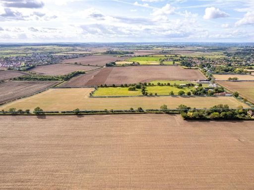 Land for sale in Tythby Road, Cropwell Butler, Nottinghamshire, NG12 — £275,000 • 1 bed • 1 bath
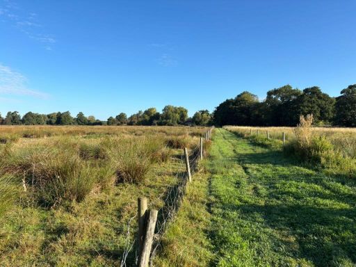 Land for sale in Land At Mill Farm | WHOLE, Bonner Lane, Calverton, Nottingham, NG14 — £365,000 • 1 bed • 1 bath
 Farm for sale in Land At Church Farm , Normanton Lane , Normanton, Nottingham, Nottinghamshire, NG13 — £1,000,000 • 1 bed • 1 bath • 7004 ft²
 Land for sale in Land At Adbolton Lane, West Bridgford, Nottingham, Nottinghamshire, NG2 — £4,500,000 • 1 bed • 1 bath
 Land for sale in Barkestone Lane, Redmile, Nottingham, NG13 — £75,000 • 1 bed • 1 bath
Meta
- {
"@context": "https://schema.org",
"@type": "Residence",
"name": "Land for sale in Off Fosse Way, Cotgrave, Nottingham, NG12",
"description": "",
"url": "https://propertypiper.co.uk/property/8828ca09-9a0e-4ece-a2d1-1281bce89b9b",
"image": "https://image-a.propertypiper.co.uk/fc37e8b3-3aee-4c8a-a06f-426384a4f541-1024.jpeg",
"address": {
"@type": "PostalAddress",
"streetAddress": "WOODLANDS, FOSSE WAY, NOTTINGHAM, COTGRAVE",
"postalCode": "NG12 3UR",
"addressLocality": "Rushcliffe",
"addressRegion": "Rushcliffe",
"addressCountry": "England"
},
"geo": {
"@type": "GeoCoordinates",
"latitude": 52.8703365,
"longitude": -1.0276658
},
"numberOfRooms": 1,
"numberOfBathroomsTotal": 1,
"offers": {
"@type": "Offer",
"price": 500000,
"priceCurrency": "GBP",
"availability": "https://schema.org/InStock"
},
"additionalProperty": [
{
"@type": "PropertyValue",
"name": "Feature",
"value": "farmland"
},
{
"@type": "PropertyValue",
"name": "Feature",
"value": "rural"
},
{
"@type": "PropertyValue",
"name": "Feature",
"value": "agricultural"
},
{
"@type": "PropertyValue",
"name": "Feature",
"value": "fields"
},
{
"@type": "PropertyValue",
"name": "Feature",
"value": "land"
},
{
"@type": "PropertyValue",
"name": "Feature",
"value": "bridge"
},
{
"@type": "PropertyValue",
"name": "Feature",
"value": "highway"
},
{
"@type": "PropertyValue",
"name": "Feature",
"value": "roadway"
},
{
"@type": "PropertyValue",
"name": "Feature",
"value": "intersection"
},
{
"@type": "PropertyValue",
"name": "Feature",
"value": "fields"
},
{
"@type": "PropertyValue",
"name": "Feature",
"value": "rural"
},
{
"@type": "PropertyValue",
"name": "Feature",
"value": "landscape"
},
{
"@type": "PropertyValue",
"name": "Feature",
"value": "modern infrastructure"
}
]
}