S20 5BJ - Plot for sale in Plot 2 Plumbley Hall Farm, Plumbley Lane,…
View on Property Piper
Plot for sale in Plot 2 Plumbley Hall Farm, Plumbley Lane, Mosborough, Sheffield, S20
Property Details
- Price: £275000
- Bedrooms: 1
- Bathrooms: 1
- Property Type: undefined
- Property SubType: undefined
Brochure Descriptions
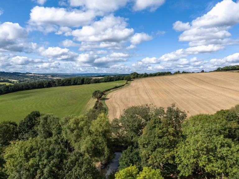
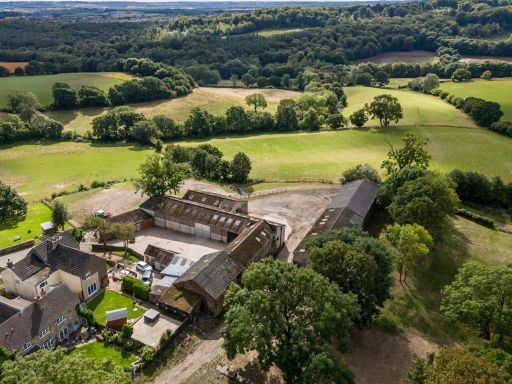
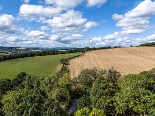
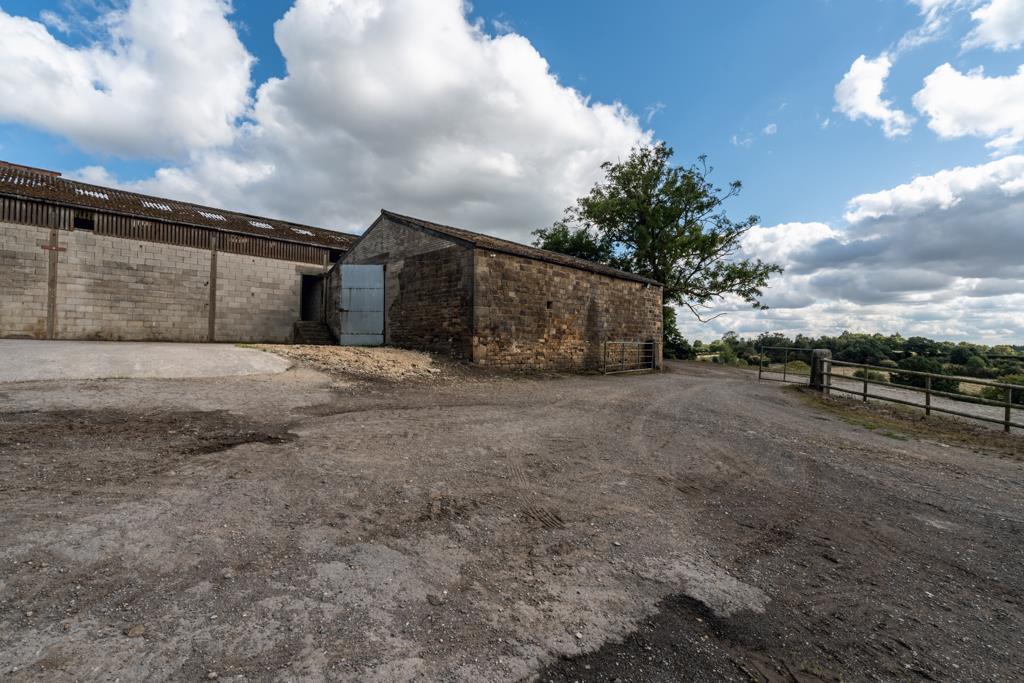
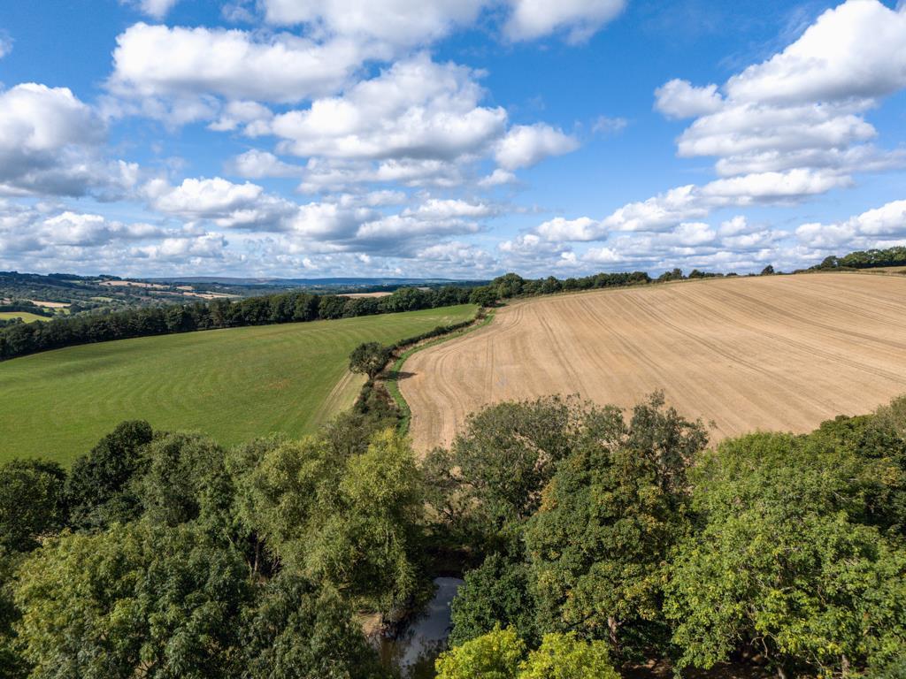
- Rural farm estate comprising Plumbley Hall Farm situated on Plumbley Lane, Mosborough. The images show expansive arable and pasture land with rolling countryside and distant panoramic views; tree belts and hedgerows define field boundaries. The setting is distinctly rural and secluded with exceptional open aspects over surrounding farmland. Garden/amenity areas are not visible but the holding is clearly large (farmland scale) and would be classified as a substantial agricultural property/estate rather than a standard residential plot. Suitable for farming, equestrian use or redevelopment subject to consent. Overall impression: large/huge property with high landscape value and strong potential for agricultural income or country-living conversion (subject to planning).
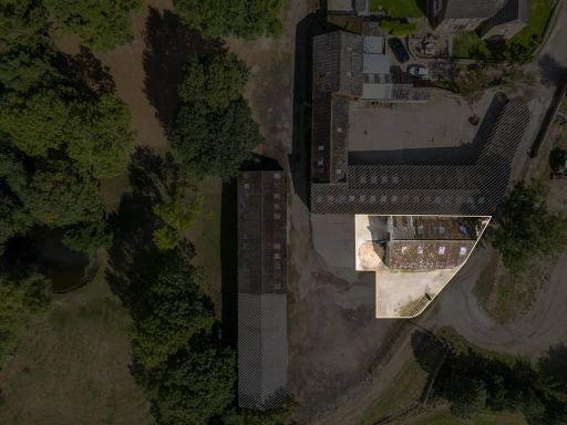
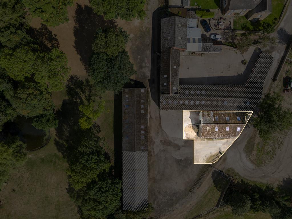
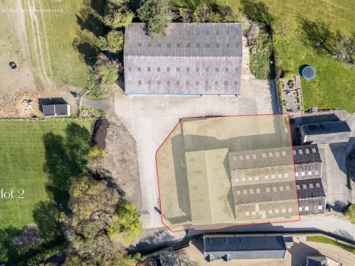
- Detached farm estate (Plumbley Hall Farm) located on Plumbley Lane in Mosborough, Sheffield. From the listing title and context this is a rural farmhouse/farm complex set within substantial grounds — likely agricultural and residential land. The property is presented as a named estate rather than a standard dwelling, indicating a large overall plot (large to very large) and substantial outbuildings/ancillary accommodation typical of a farm. Setting is rural/suburban on the edge of Sheffield (South Yorkshire); likely offers open countryside and farmland views. Suitable for purchasers seeking a large country residence with extensive land; valuation considerations would include plot size, agricultural buildings, access, planning/use potential and proximity to local services and transport. No internal layout, room sizes or exact plot area are visible from the images provided.
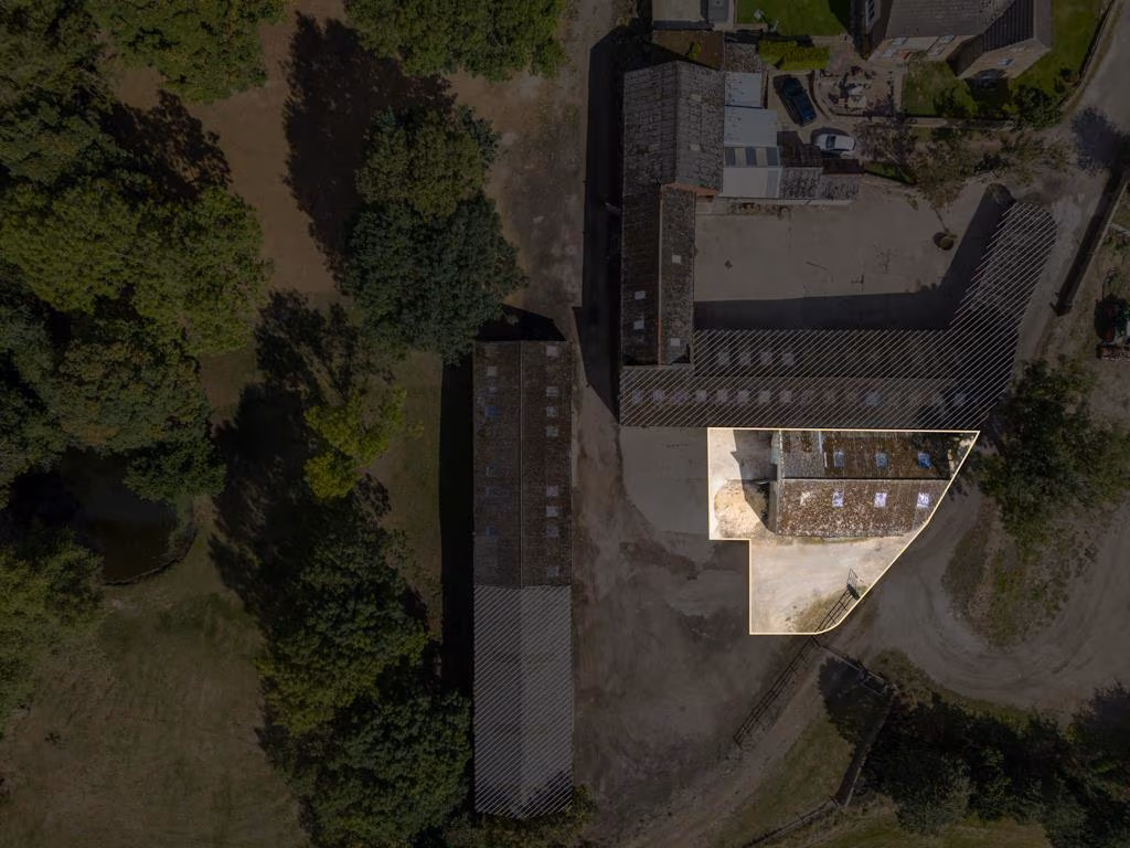
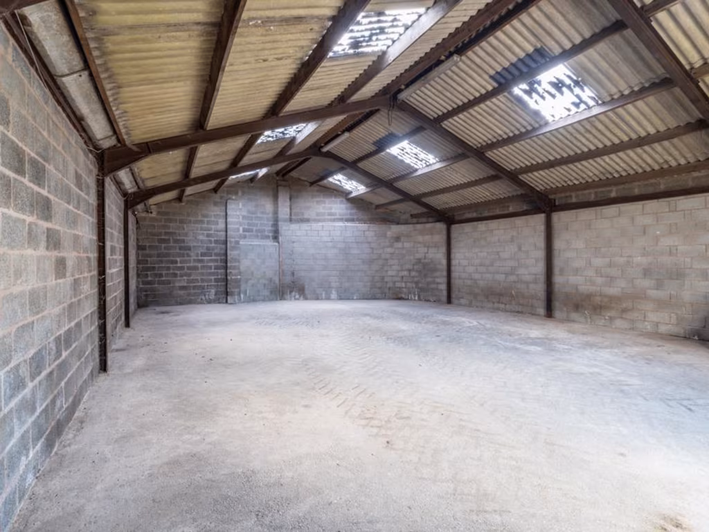
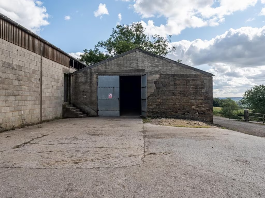
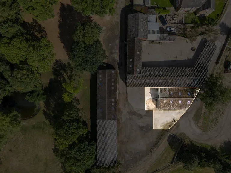
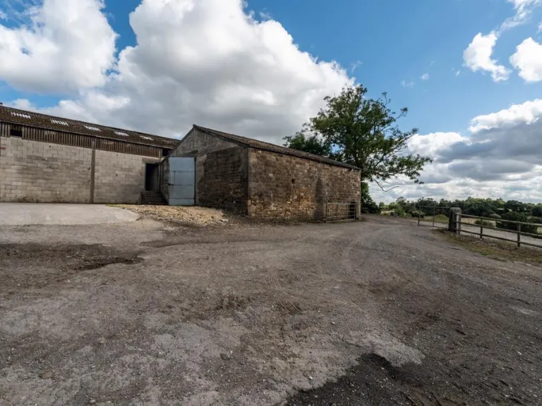
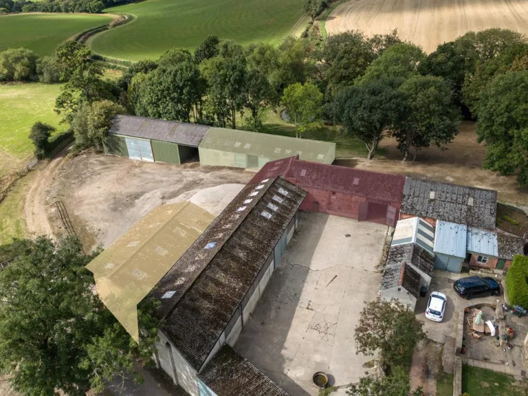
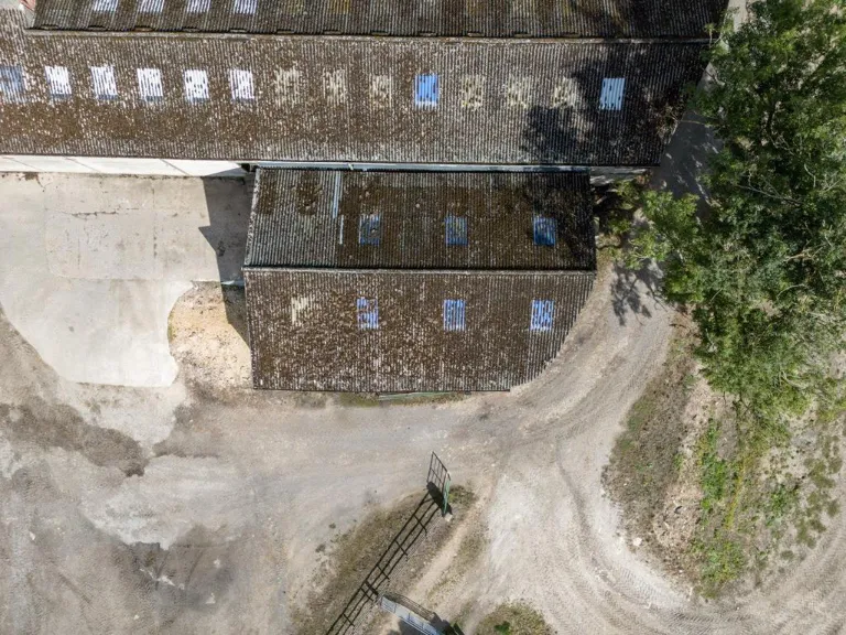
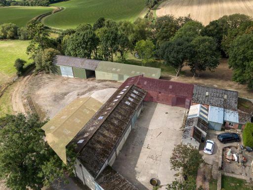
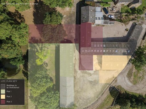
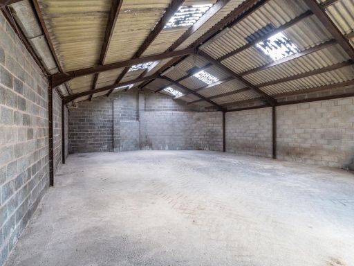
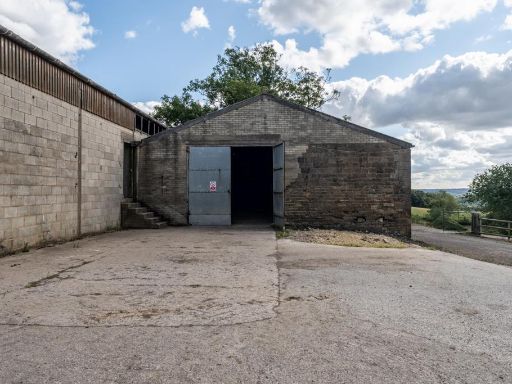
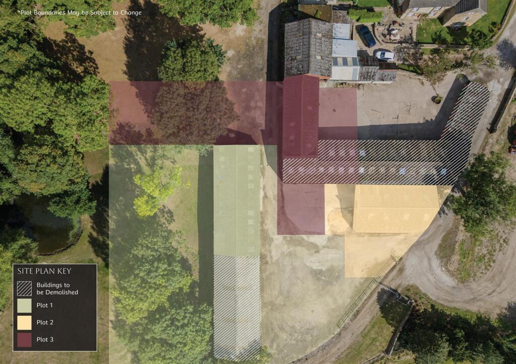
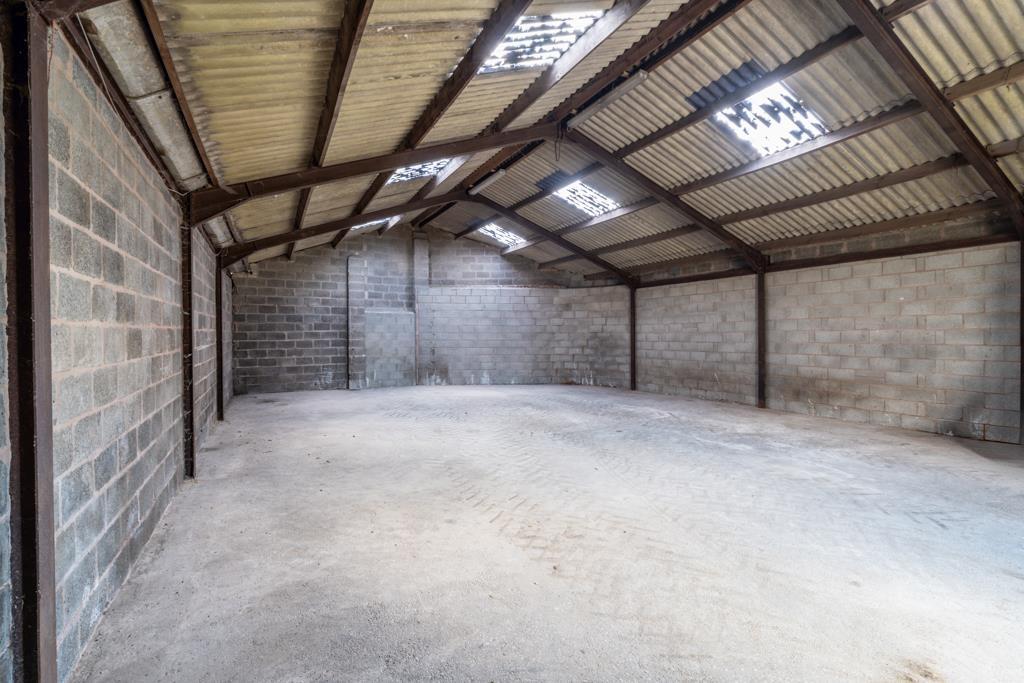
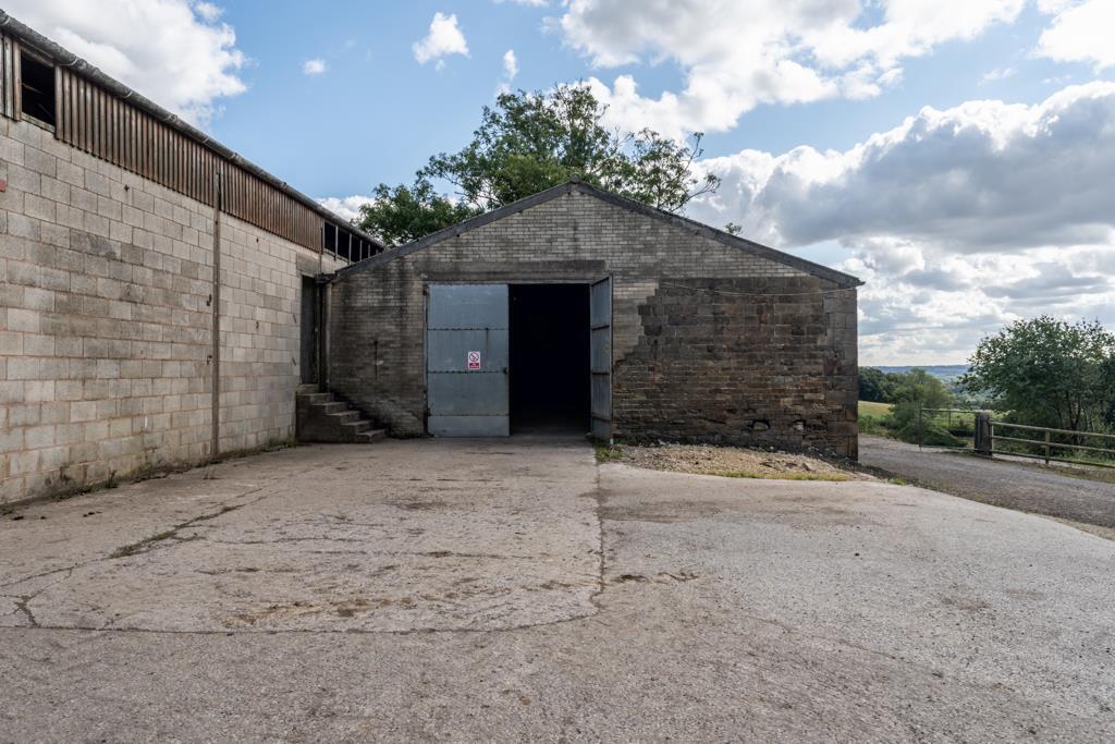
- A rural farmstead set within rolling arable countryside and bordered by mature trees/woodland. The site comprises a cluster of agricultural buildings and barns arranged around a concrete yard, with large open fields visible to the north and east. The setting offers extensive countryside views and vehicular access via a farm drive. Garden/amenity land is substantial (large), with the overall holding appearing to be a large agricultural/development plot rather than a typical residential garden. The buildings are typical farm/industrial sheds (potential for conversion subject to planning) and the overall property footprint is large, suitable for redevelopment or continuing agricultural use. No internal accommodation or room details are visible in the images.
Image Descriptions
- barn complex agricultural
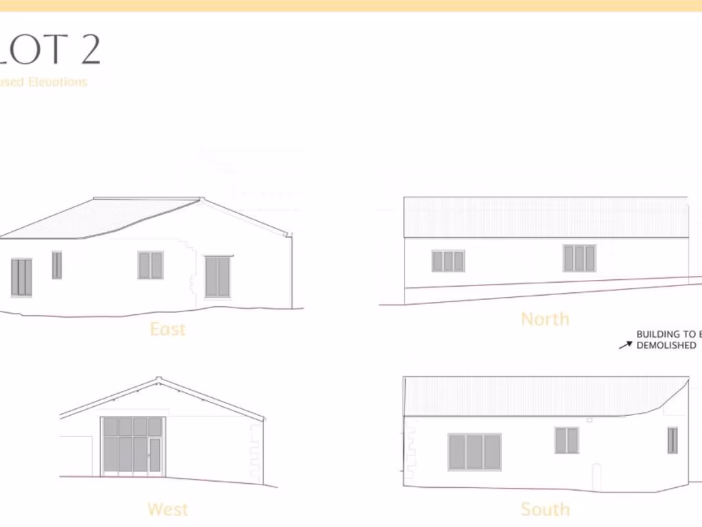
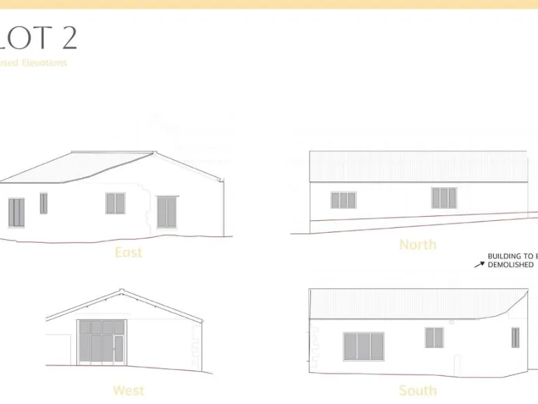
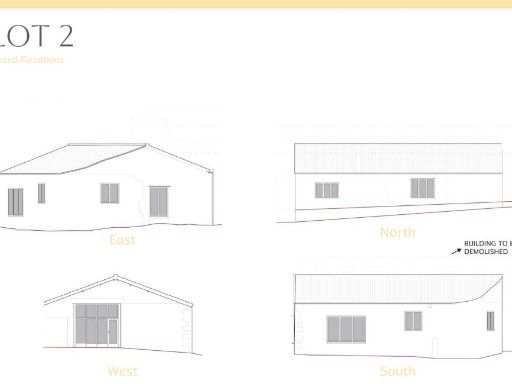
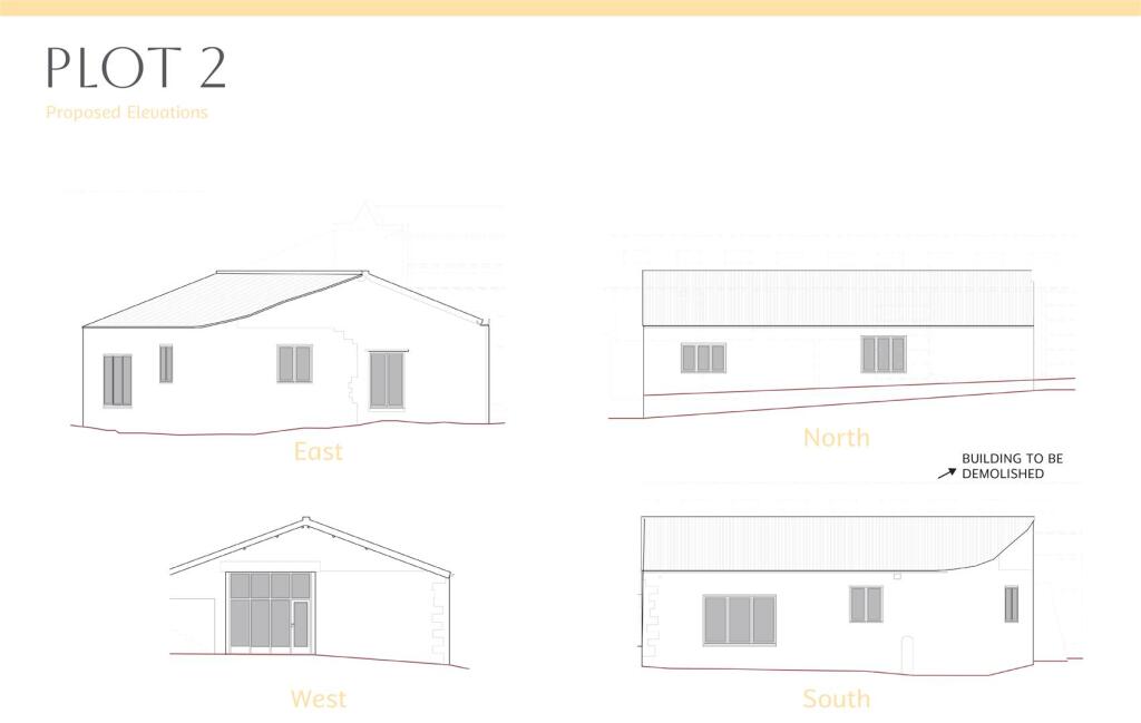
- elevations of a single-story building modern
Floorplan Description
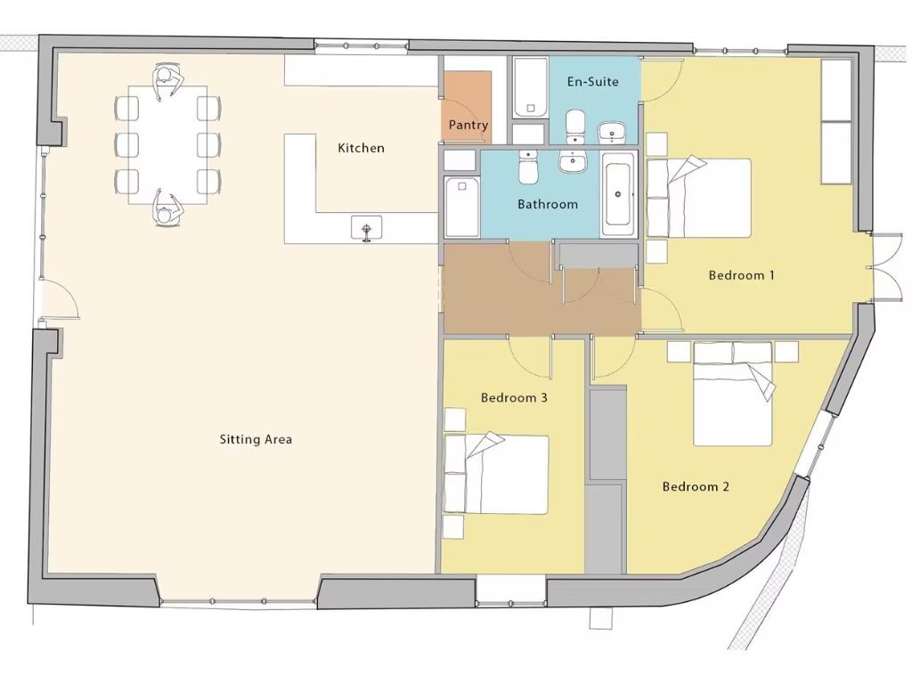
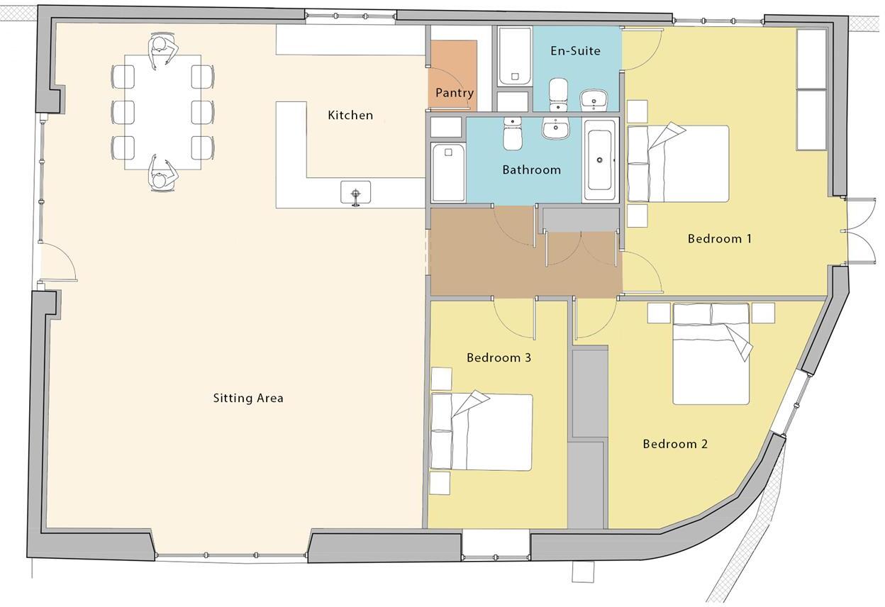
- Floorplan showing an open sitting area with kitchen, pantry, bathroom, en-suite and three bedrooms
Rooms
- Kitchen:
- Pantry:
- Sitting Area:
- En-Suite:
- Bathroom:
- Bedroom 1:
- Bedroom 2:
- Bedroom 3:
Textual Property Features
Detected Visual Features
- barn
- conversion potential
- rustic
- agricultural
- large spaces
- outbuilding
- rural
- renovation
- development opportunity
- modern
- single-story
- elevations
- drawing
- garage
- yard
- country property
Nearby Schools
- Marsh Lane Primary School
- Birley Spa Primary Academy
- Intake Primary School
- Birk Hill Infant & Nursery School
- Halfway Junior School
- Shortbrook Primary School
- Waterthorpe Infant School
- Birley Primary Academy
- Rainbow Forge Primary Academy
- Reignhead Primary School
- Woodhouse West Primary School
- Brunswick Community Primary School
- Ballifield Primary School
- Eckington School
- Mosborough Primary School
- Ridgeway Primary School
- The Birley Academy
- St John Fisher Primary, A Catholic Voluntary Academy
- Eckington Junior School
- Camms CofE (Aided) Primary School
- Halfway Nursery Infant School
- Emmanuel Anglican/Methodist Junior School
- Westfield School
- Charnock Hall Primary Academy
- Outwood Academy City
- Stradbroke Primary School
- Handsworth Grange Community Sports College
Nearest General Shops
- Id: 151300722
- Tags:
- Landuse: commercial
- Shop: garden_centre
- Source: Bing
- TagsNormalized:
- Lat: 53.338123
- Lon: -1.3867365
- FullGeoHash: gcrp2myjndy3
- PartitionGeoHash: gcrp
- Images:
- FoodStandards: null
- Distance: 1737.1
,- Id: 360991207
- Tags:
- Brand: Ladbrokes
- Brand:wikidata: Q1799875
- Brand:wikipedia: en:Ladbrokes Coral
- Building: yes
- Name: Ladbrokes
- Shop: bookmaker
- TagsNormalized:
- Lat: 53.3267446
- Lon: -1.3623813
- FullGeoHash: gcrp2gzfy1wy
- PartitionGeoHash: gcrp
- Images:
- FoodStandards: null
- Distance: 1209.5
,- Id: 298446313
- Tags:
- TagsNormalized:
- Lat: 53.3212997
- Lon: -1.3644495
- FullGeoHash: gcrp2fy7n48w
- PartitionGeoHash: gcrp
- Images:
- FoodStandards: null
- Distance: 1022.3
}
Nearest Grocery shops
- Id: 332164412
- Tags:
- Addr:
- City: Eckington
- Postcode: S21 4EX
- Street: Pinfold Street
- Area: yes
- Building: yes
- Fhrs:
- Name: The Co-operative Food
- Operator: Central England Co-operative
- Shop: supermarket
- TagsNormalized:
- the co-operative food
- food
- shop
- Lat: 53.3094844
- Lon: -1.3577796
- FullGeoHash: gcrp30eq32nj
- PartitionGeoHash: gcrp
- Images:
- FoodStandards:
- Id: 351387
- FHRSID: 351387
- LocalAuthorityBusinessID: PI/000101543
- BusinessName: Central England Co-operative Society Ltd
- BusinessType: Retailers - supermarkets/hypermarkets
- BusinessTypeID: 7840
- AddressLine1: Central England Co-operative Society
- AddressLine2: Pinfold Street
- AddressLine3: Eckington
- AddressLine4: Chesterfield
- PostCode: S21 4EX
- RatingValue: 5
- RatingKey: fhrs_5_en-GB
- RatingDate: 2021-06-10
- LocalAuthorityCode: 068
- LocalAuthorityName: North East Derbyshire
- LocalAuthorityWebSite: http://www.ne-derbyshire.gov.uk/
- LocalAuthorityEmailAddress: envhealth@ne-derbyshire.gov.uk
- Scores:
- Hygiene: 0
- Structural: 5
- ConfidenceInManagement: 0
- NewRatingPending: false
- Geocode:
- Longitude: null
- Latitude: null
- Distance: 2093.6
,- Id: 397492053
- Tags:
- Brand: One Stop
- Brand:wikidata: Q65954217
- Building: yes
- Disused:
- Name: One Stop
- Old_name: The West End
- Shop: convenience
- TagsNormalized:
- Lat: 53.3056839
- Lon: -1.3697962
- FullGeoHash: gcrp2b4817ty
- PartitionGeoHash: gcrp
- Images:
- FoodStandards: null
- Distance: 2042.3
,- Id: 390506899
- Tags:
- Name: Harry's General Store
- Shop: convenience
- TagsNormalized:
- Lat: 53.3082518
- Lon: -1.3744933
- FullGeoHash: gcrp28rp5frs
- PartitionGeoHash: gcrp
- Images:
- FoodStandards: null
- Distance: 1685.1
}
Nearest Religious buildings
- Id: 204722804
- Tags:
- Amenity: place_of_worship
- Building: church
- Denomination: anglican
- Name: St Mark's Church
- Religion: christian
- Source: Bing
- Wikidata: Q105103016
- TagsNormalized:
- place of worship
- church
- anglican
- christian
- Lat: 53.3247362
- Lon: -1.3614837
- FullGeoHash: gcrp352x55k1
- PartitionGeoHash: gcrp
- Images:
- FoodStandards: null
- Distance: 1213
,- Id: 360993660
- Tags:
- Addr:
- City: Sheffield
- Postcode: S20 5BU
- Street: Cadman Street
- Amenity: place_of_worship
- Building: yes
- Denomination: methodist
- Fhrs:
- Name: Mosborough Methodist
- Religion: christian
- TagsNormalized:
- place of worship
- methodist
- christian
- church
- Lat: 53.3237078
- Lon: -1.3644134
- FullGeoHash: gcrp2gq3ngee
- PartitionGeoHash: gcrp
- Images:
- FoodStandards: null
- Distance: 1007.1
,- Id: 360993656
- Tags:
- Addr:
- City: Sheffield
- Housenumber: 79
- Postcode: S20 5BP
- Street: Queen Street
- Alt_name: Elim Pentecostal Church
- Amenity: place_of_worship
- Building: yes
- Denomination: pentecostal
- Fhrs:
- Name: Mosborough, Elim Church
- Religion: christian
- TagsNormalized:
- place of worship
- pentecostal
- church
- christian
- Lat: 53.324162
- Lon: -1.3648759
- FullGeoHash: gcrp2gq5u06b
- PartitionGeoHash: gcrp
- Images:
- FoodStandards:
- Id: 557883
- FHRSID: 557883
- LocalAuthorityBusinessID: 16946
- BusinessName: Mosborough Elim Church
- BusinessType: Other catering premises
- BusinessTypeID: 7841
- AddressLine1: Elim Pentecostal Church
- AddressLine2: 79 Queen Street
- AddressLine3: Mosborough
- AddressLine4: Sheffield
- PostCode: S20 5BP
- RatingValue: 5
- RatingKey: fhrs_5_en-GB
- RatingDate: 2014-05-20
- LocalAuthorityCode: 425
- LocalAuthorityName: Sheffield
- LocalAuthorityWebSite: https://www.sheffield.gov.uk
- LocalAuthorityEmailAddress: healthprotection@sheffield.gov.uk
- Scores:
- Hygiene: 0
- Structural: 0
- ConfidenceInManagement: 0
- NewRatingPending: false
- Geocode:
- Longitude: -1.36440800000000
- Latitude: 53.32519900000000
- Distance: 981.2
}
Nearest Medical buildings
- Id: 396196567
- Tags:
- Amenity: dentist
- Building: yes
- Healthcare: dentist
- Name: Eckington Dental Surgery
- TagsNormalized:
- dentist
- health
- healthcare
- dental
- surgery
- Lat: 53.309131
- Lon: -1.3572911
- FullGeoHash: gcrp30eshy63
- PartitionGeoHash: gcrp
- Images:
- FoodStandards: null
- Distance: 2144.4
,- Id: 99202379
- Tags:
- Addr:
- City: Sheffield
- Postcode: S20 6PD
- Street: Moorthorpe Bank
- Amenity: doctors
- Building: yes
- Healthcare: doctor
- Name: Owlthorpe Surgery
- TagsNormalized:
- doctor
- doctors
- health
- healthcare
- surgery
- Lat: 53.3386546
- Lon: -1.3759439
- FullGeoHash: gcrp2wn04jvu
- PartitionGeoHash: gcrp
- Images:
- FoodStandards: null
- Distance: 1745.7
,- Id: 6134814953
- Tags:
- Amenity: pharmacy
- Dispensing: yes
- Healthcare: pharmacy
- TagsNormalized:
- Lat: 53.3253442
- Lon: -1.364715
- FullGeoHash: gcrp2gw4xuds
- PartitionGeoHash: gcrp
- Images:
- FoodStandards: null
- Distance: 1015.8
,- Id: 360993072
- Tags:
- Amenity: doctors
- Building: yes
- Healthcare: doctor
- Name: Mosborough Health Centre
- TagsNormalized:
- doctor
- doctors
- health
- healthcare
- health centre
- Lat: 53.3255494
- Lon: -1.3648304
- FullGeoHash: gcrp2gw5v4us
- PartitionGeoHash: gcrp
- Images:
- FoodStandards: null
- Distance: 1014.2
}
Nearest Airports
- Id: 100889514
- Tags:
- Addr:
- Aerodrome: international
- Aerodrome:type: public
- Area: yes
- Cities_served: Doncaster, Sheffield
- Closest_town: Doncaster
- Disused:
- Ele: 17
- Iata: DSA
- Icao: EGCN
- Ifr: yes
- Is_in: Finningley
- Name: Doncaster Sheffield Airport
- Old_iata: FNY
- Old_icao: EGXI
- Old_name: RAF Finningley
- Old_operator: Royal Air Force
- Old_type: military
- Operator: Doncaster Sheffield Airport Limited/Peel Airports
- Source: wikipedia
- Tower_frequency: 128.775
- Vfr: yes
- Website: https://www.robinhoodairport.com/
- Wikidata: Q8996
- Wikipedia: en:Robin Hood Airport Doncaster Sheffield
- TagsNormalized:
- airport
- international airport
- Lat: 53.4761577
- Lon: -1.0054086
- FullGeoHash: gcx21p5chq34
- PartitionGeoHash: gcx2
- Images:
- FoodStandards: null
- Distance: 30081.4
}
Nearest Leisure Facilities
- Id: 298446314
- Tags:
- TagsNormalized:
- Lat: 53.3206559
- Lon: -1.3648695
- FullGeoHash: gcrp2fwpk4xt
- PartitionGeoHash: gcrp
- Images:
- FoodStandards: null
- Distance: 1011.8
,- Id: 327151198
- Tags:
- Leisure: pitch
- Sport: soccer
- TagsNormalized:
- Lat: 53.3258505
- Lon: -1.3671279
- FullGeoHash: gcrp2gsmxe58
- PartitionGeoHash: gcrp
- Images:
- FoodStandards: null
- Distance: 879.3
,- Id: 361401368
- Tags:
- TagsNormalized:
- Lat: 53.3256985
- Lon: -1.3693929
- FullGeoHash: gcrp2gdudydw
- PartitionGeoHash: gcrp
- Images:
- FoodStandards: null
- Distance: 733.2
,- Id: 326602337
- Tags:
- TagsNormalized:
- Lat: 53.3258002
- Lon: -1.3697443
- FullGeoHash: gcrp2gdt69ss
- PartitionGeoHash: gcrp
- Images:
- FoodStandards: null
- Distance: 716.5
,- Id: 298447554
- Tags:
- TagsNormalized:
- Lat: 53.3229256
- Lon: -1.3790389
- FullGeoHash: gcrp2e5ud1f1
- PartitionGeoHash: gcrp
- Images:
- FoodStandards: null
- Distance: 38.8
}
Nearest Tourist attractions
- Id: 4731691
- Tags:
- Building: yes
- Tourism: museum
- Type: multipolygon
- TagsNormalized:
- Lat: 53.3027376
- Lon: -1.3468502
- FullGeoHash: gcrp1r7qbn7w
- PartitionGeoHash: gcrp
- Images:
- FoodStandards: null
- Distance: 3137.7
,- Id: 390506883
- Tags:
- Name: Ravencar Farm Bed & Breakfast
- Postal_code: S21 5RH
- Tourism: guest_house
- TagsNormalized:
- bed
- farm
- guest house
- tourism
- Lat: 53.3068305
- Lon: -1.3812472
- FullGeoHash: gcrp284ny97q
- PartitionGeoHash: gcrp
- Images:
- FoodStandards: null
- Distance: 1813
,- Id: 162040460
- Tags:
- Name: Bramley Park
- Source: Bing
- Tourism: caravan_site
- TagsNormalized:
- Lat: 53.309021
- Lon: -1.3883404
- FullGeoHash: gcrp22t593f2
- PartitionGeoHash: gcrp
- Images:
- FoodStandards: null
- Distance: 1671.4
}
Nearest Train stations
- Id: 3157354104
- Tags:
- Name: Darnall
- Naptan:
- Network: National Rail
- Operator: Northern Rail
- Public_transport: station
- Railway: station
- Ref:
- Source: wikipedia
- Wikidata: Q2975270
- Wikipedia: en:Darnall railway station
- TagsNormalized:
- Lat: 53.3845451
- Lon: -1.4123572
- FullGeoHash: gcqzxy7e98qp
- PartitionGeoHash: gcqz
- Images:
- FoodStandards: null
- Distance: 7170.8
,- Id: 370186628
- Tags:
- Name: Dronfield
- Naptan:
- Network: National Rail
- Platforms: 2
- Public_transport: station
- Railway: station
- Ref:
- Wikidata: Q2161199
- Wikipedia: en:Dronfield railway station
- TagsNormalized:
- Lat: 53.3014
- Lon: -1.4692529
- FullGeoHash: gcqznx4p5vje
- PartitionGeoHash: gcqz
- Images:
- FoodStandards: null
- Distance: 6429.9
,- Id: 102031003
- Tags:
- Building: train_station
- Name: Barrow Hill Roundhouse
- Railway: turntable
- Tourism: attraction
- Wikidata: Q4863884
- Wikipedia: en:Barrow Hill Engine Shed
- TagsNormalized:
- station
- train
- train station
- railway
- attraction
- tourism
- Lat: 53.2744292
- Lon: -1.381839
- FullGeoHash: gcrp0d3f0c6h
- PartitionGeoHash: gcrp
- Images:
- FoodStandards: null
- Distance: 5414.4
,- Id: 1716256015
- Tags:
- Name: Roundhouse Halt
- Public_transport: station
- Railway: station
- Usage: tourism
- Website: https://www.barrowhill.org/
- TagsNormalized:
- Lat: 53.2746594
- Lon: -1.3813376
- FullGeoHash: gcrp0d65ks21
- PartitionGeoHash: gcrp
- Images:
- FoodStandards: null
- Distance: 5388
,- Id: 3157353528
- Tags:
- Name: Woodhouse
- Naptan:
- Network: National Rail
- Operator: Northern Rail
- Public_transport: station
- Railway: station
- Ref:
- Source: wikipedia
- Wikidata: Q2497249
- Wikipedia: en:Woodhouse railway station
- TagsNormalized:
- Lat: 53.3637962
- Lon: -1.3573689
- FullGeoHash: gcrp94edeh87
- PartitionGeoHash: gcrp
- Images:
- FoodStandards: null
- Distance: 4758.3
}
Nearest Hotels
- Id: 139941018
- Tags:
- Addr:
- City: Sheffield
- Housenumber: 66
- Postcode: S12 4WB
- Street: Birley Moor Road
- Amenity: pub
- Building: yes
- Fhrs:
- Name: The Birley Hotel
- Source: Bing
- TagsNormalized:
- Lat: 53.3486772
- Lon: -1.4012461
- FullGeoHash: gcrp2pgdsd5p
- PartitionGeoHash: gcrp
- Images:
- FoodStandards: null
- Distance: 3188
,- Id: 363773497
- Tags:
- Amenity: pub
- Building: yes
- Name: The Royal Hotel
- TagsNormalized:
- Lat: 53.3090001
- Lon: -1.3552534
- FullGeoHash: gcrp30t5kmcu
- PartitionGeoHash: gcrp
- Images:
- FoodStandards: null
- Distance: 2250
,- Id: 343389600
- Tags:
- Addr:
- City: Sheffield
- Country: GB
- Postcode: S20 5EA
- Street: High Street
- Fhrs:
- Name: Mosborough Hall Hotel
- Operator: Best Westen
- Tourism: hotel
- TagsNormalized:
- Lat: 53.3215943
- Lon: -1.3567463
- FullGeoHash: gcrp34uhc98e
- PartitionGeoHash: gcrp
- Images:
- FoodStandards: null
- Distance: 1523.3
}
Tags
- barn
- conversion potential
- rustic
- agricultural
- large spaces
- outbuilding
- rural
- renovation
- development opportunity
- modern
- single-story
- elevations
- drawing
- garage
- yard
- country property
Local Market Stats
- Average Price/sqft: £238
- Avg Income: £41300
- Rental Yield: 4.8%
- Social Housing: 13%
- Planning Success Rate: 89%
Similar Properties
 Plot for sale in Plot 2 Mount View Farm, Parkhall Lane, Spinkhill, Sheffield, S21 — £400,000 • 1 bed • 1 bath • 3100 ft²
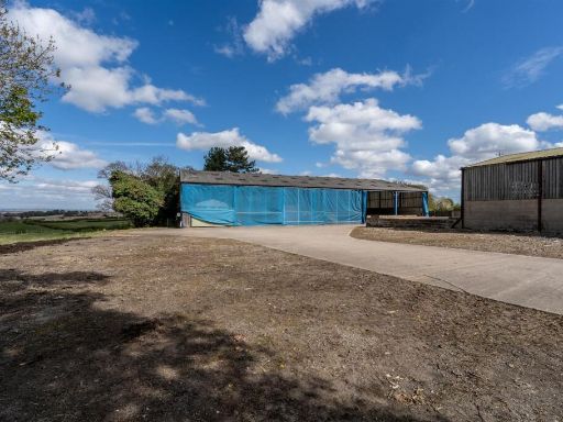 Plot for sale in Parkhall Lane, Spinkhill, Sheffield, S21 — £895,000 • 1 bed • 1 bath • 13498 ft²
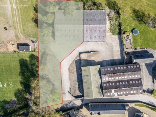 Plot for sale in Plot 3 Mount View Farm, Parkhall Lane, Spinkhill, Sheffield, S21 — £450,000 • 1 bed • 1 bath • 4349 ft²
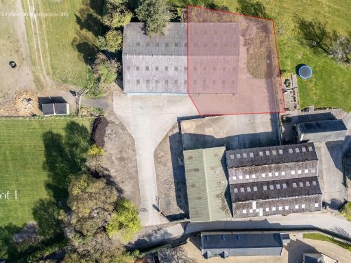 Plot for sale in Plot 1 Mount View Farm, Parkhall Lane, Spinkhill, Sheffield, S21 — £350,000 • 1 bed • 1 bath • 4349 ft²
 Plot for sale in Derbyshire Lane, Sheffield, S8 — £240,000 • 4 bed • 4 bath • 1948 ft²
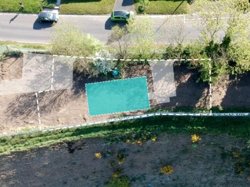 Plot for sale in Derbyshire Lane, Sheffield, S8 — £148,000 • 4 bed • 4 bath • 1238 ft²
Meta
- {
"@context": "https://schema.org",
"@type": "Residence",
"name": "Plot for sale in Plot 2 Plumbley Hall Farm, Plumbley Lane,…",
"description": "",
"url": "https://propertypiper.co.uk/property/87e64563-ff44-4d44-a81f-c9deae8e10a8",
"image": "https://image-a.propertypiper.co.uk/1be5f5f2-7069-42ed-b0c8-0820973b1497-1024.jpeg",
"address": {
"@type": "PostalAddress",
"streetAddress": "PLUMBLEY LANE FARM PLUMBLEY LANE MOSBOROUGH SHEFFIELD",
"postalCode": "S20 5BJ",
"addressLocality": "Sheffield",
"addressRegion": "Sheffield South East",
"addressCountry": "England"
},
"geo": {
"@type": "GeoCoordinates",
"latitude": 53.32310314397219,
"longitude": -1.379542228061097
},
"numberOfRooms": 1,
"numberOfBathroomsTotal": 1,
"floorSize": {
"@type": "QuantitativeValue",
"value": 1550,
"unitCode": "FTK"
},
"offers": {
"@type": "Offer",
"price": 275000,
"priceCurrency": "GBP",
"availability": "https://schema.org/InStock"
},
"additionalProperty": [
{
"@type": "PropertyValue",
"name": "Feature",
"value": "barn"
},
{
"@type": "PropertyValue",
"name": "Feature",
"value": "conversion potential"
},
{
"@type": "PropertyValue",
"name": "Feature",
"value": "rustic"
},
{
"@type": "PropertyValue",
"name": "Feature",
"value": "agricultural"
},
{
"@type": "PropertyValue",
"name": "Feature",
"value": "large spaces"
},
{
"@type": "PropertyValue",
"name": "Feature",
"value": "outbuilding"
},
{
"@type": "PropertyValue",
"name": "Feature",
"value": "rural"
},
{
"@type": "PropertyValue",
"name": "Feature",
"value": "renovation"
},
{
"@type": "PropertyValue",
"name": "Feature",
"value": "development opportunity"
},
{
"@type": "PropertyValue",
"name": "Feature",
"value": "modern"
},
{
"@type": "PropertyValue",
"name": "Feature",
"value": "single-story"
},
{
"@type": "PropertyValue",
"name": "Feature",
"value": "elevations"
},
{
"@type": "PropertyValue",
"name": "Feature",
"value": "drawing"
},
{
"@type": "PropertyValue",
"name": "Feature",
"value": "garage"
},
{
"@type": "PropertyValue",
"name": "Feature",
"value": "yard"
},
{
"@type": "PropertyValue",
"name": "Feature",
"value": "country property"
}
]
}
High Res Floorplan Images
Compatible Floorplan Images
FloorplanImages Thumbnail