TD9 0LT - Farm land for sale in Lot 2 Land at Dinley, TD9
View on Property Piper
Farm land for sale in Lot 2 - Land at Dinley, TD9
Property Details
- Price: £650000
- Bedrooms: 1
- Bathrooms: 1
- Property Type: undefined
- Property SubType: undefined
Brochure Descriptions
- The image is a map highlighting four separate land lots outlined in different colors (red, blue, purple, orange). These lots encompass large rural tracts, likely agricultural, pasture, or moorland, separated by boundary lines and intersected by minor rural roads. There are no visible structures, houses, or clear property address markers on the map, and no obvious sea, river, or forest views are depicted. The overall size of each lot appears very large, covering hundreds of acres each; these are expansive rural parcels, suitable for farming, grazing, or potential future development.
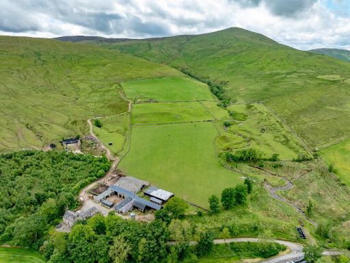
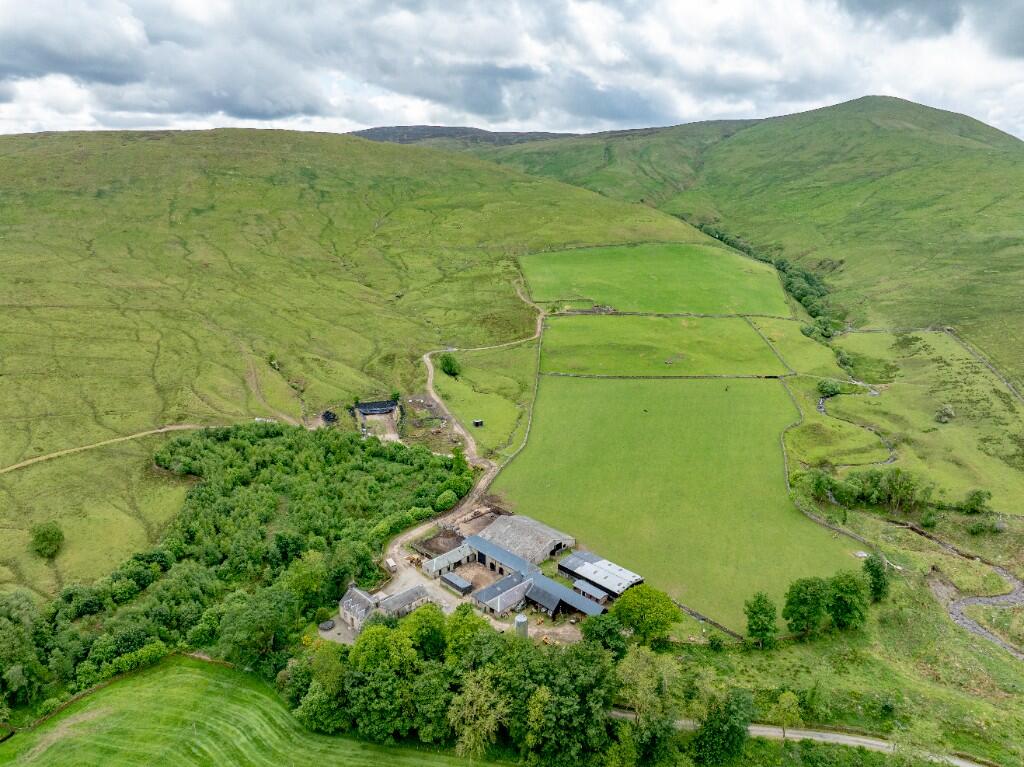
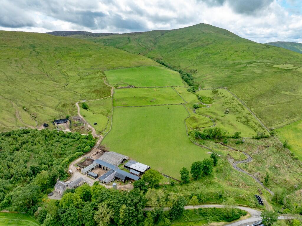
- Dinley Farm is a substantial rural property offered in multiple lots, primarily consisting of large expanses of agricultural land, including a mix of permanent pasture, temporary pasture, woodland, rough grazing, fell, and areas adjoining a river/woodland setting. The lots vary in character, with Lot 1 and Lot 2 featuring steading, track, significant pasture, and woodland, suitable for both livestock and agricultural use. Lot 3 comprises a vast area of fell and grazing land, ideal for extensive farming or sheep grazing. Lot 4 is a small lot with a cottage, likely a traditional rural dwelling, and minor additional land. The property enjoys extensive countryside views, including river and woodland aspects, with overall generous to huge landholdings totalling approximately 1518.86 acres (614.66 hectares), indicating a substantial rural estate.
- The property is a substantial detached period house named Dinley, set within a large rural estate. The house appears to be constructed of stone with classic architectural features, featuring symmetrical front gables and multiple chimneys. It is surrounded by mature gardens with large trees and well-tended landscaping, providing privacy and scenic beauty. The estate includes several stone outbuildings and barns, suggesting potential for equestrian or agricultural use. The setting is remote and picturesque, with expansive green fields and hills providing uninterrupted countryside views. The overall property and garden size is large, offering a feeling of seclusion and tranquility.
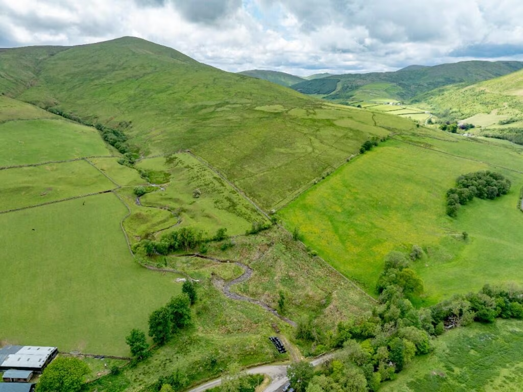
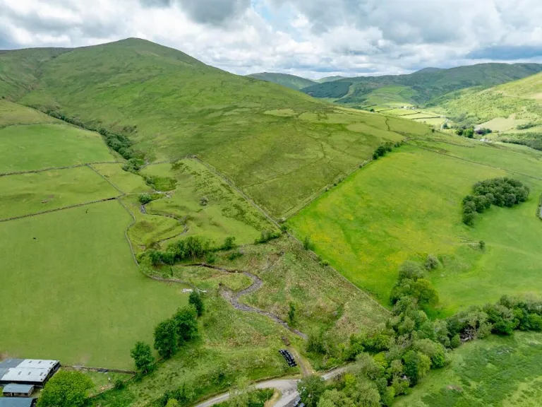
- The property is a remote and substantial detached rural house, possibly a farmhouse set within expansive, rolling fields and open countryside. The site appears to feature a large plot of land, likely used for grazing or other agricultural purposes. The house is surrounded by grassland, with woodland bordering one side, offering an exceptional, unobstructed view across the hills and valleys of the region. The garden and grounds are large, matching the rural and private setting. There are no immediate neighbouring buildings nearby, confirming the secluded nature and significant size of the property. No river, sea or city views are visible—just open countryside with a backdrop of hills.
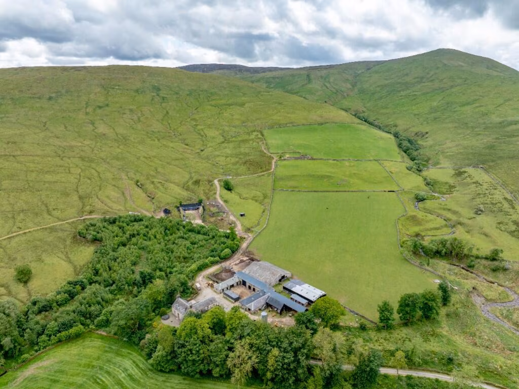
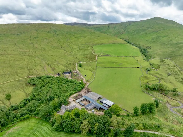
- This property is a substantial rural estate and farmstead set in extensive rolling hills and green pastures. The main house and associated outbuildings are surrounded by large fields, some demarcated by traditional stone walls. There is an exceptional panoramic open view over countryside and hills, with woodlands and river/stream visible on the periphery. The buildings are expansive, likely including a main residence and agricultural outbuildings, set within a very large plot spanning dozens of acres. This is a rare opportunity for an agricultural, equestrian or lifestyle property with seclusion and sweeping vistas.
Image Descriptions
- rural farmstead farmhouse
- rural estate rural
Textual Property Features
Detected Visual Features
- rural
- farmhouse
- barn
- isolation
- scenic
- rolling hills
- country living
- agriculture
- expansive land
- detached property
- landscape views
- privacy
- estate
- large plot
- agricultural
- countryside
- farm
- secluded
- fields
- land
Nearest General Shops
- Id: 1663626175
- Tags:
- Addr:
- Housenumber: 46
- Postcode: TD9 0RA
- Street: North Hermitage Street
- Fhrs:
- Name: T. Elliot & Sons
- Shop: butcher
- TagsNormalized:
- Lat: 55.1803723
- Lon: -2.8124117
- FullGeoHash: gcy1bj20fncy
- PartitionGeoHash: gcy1
- Images:
- FoodStandards:
- Id: 56050
- FHRSID: 56050
- LocalAuthorityBusinessID: 12660/0046/0/000
- BusinessName: T Elliot And Sons
- BusinessType: Manufacturers/packers
- BusinessTypeID: 7839
- AddressLine1: 46 North Hermitage Street Newcastleton Roxburghshire
- AddressLine2: null
- AddressLine3: null
- AddressLine4: null
- PostCode: TD9 0RA
- RatingValue: Pass
- RatingKey: fhis_pass_en-GB
- RatingDate: 2019-08-15
- LocalAuthorityCode: 767
- LocalAuthorityName: Scottish Borders
- LocalAuthorityWebSite: http://www.scotborders.gov.uk/
- LocalAuthorityEmailAddress: foodteam@scotborders.gov.uk
- Scores:
- Hygiene: null
- Structural: null
- ConfidenceInManagement: null
- NewRatingPending: false
- Geocode:
- Longitude: -2.81155200000000
- Latitude: 55.18136200000000
- Distance: 9387.2
,- Id: 1663639261
- Tags:
- Addr:
- Housenumber: 44
- Postcode: TD9 0RA
- Street: North Hermitage Street
- Name: Border Autoservices
- Shop: car_repair
- TagsNormalized:
- service
- car repair
- repair
- shop
- Lat: 55.180648
- Lon: -2.812299
- FullGeoHash: gcy1bj24sdmf
- PartitionGeoHash: gcy1
- Images:
- FoodStandards: null
- Distance: 9357.2
,- Id: 9584788662
- Tags:
- TagsNormalized:
- Lat: 55.2559553
- Lon: -2.7948927
- FullGeoHash: gcy427hc628u
- PartitionGeoHash: gcy4
- Images:
- FoodStandards: null
- Distance: 2044.9
}
Nearest Grocery shops
- Id: 240724552
- Tags:
- Addr:
- City: Kielder
- County: Northumberland
- Housenumber: 32
- Postcode: NE48 1EQ
- Street: Castle Drive
- Building: yes
- Fhrs:
- Name: Kielder Village Store and Post Office
- Operator: Lifestyle Express
- Shop: convenience
- TagsNormalized:
- office
- post office
- convenience
- shop
- Lat: 55.2345612
- Lon: -2.5853823
- FullGeoHash: gcy4jpjkshrp
- PartitionGeoHash: gcy4
- Images:
- FoodStandards:
- Id: 286926
- FHRSID: 286926
- LocalAuthorityBusinessID: 4410
- BusinessName: Kielder Village Store
- BusinessType: Retailers - other
- BusinessTypeID: 4613
- AddressLine1: 32 Castle Drive
- AddressLine2: Kielder
- AddressLine3: Northumberland
- AddressLine4: null
- PostCode: NE48 1EQ
- RatingValue: 5
- RatingKey: fhrs_5_en-GB
- RatingDate: 2019-03-01
- LocalAuthorityCode: 707
- LocalAuthorityName: Northumberland
- LocalAuthorityWebSite: http://www.northumberland.gov.uk
- LocalAuthorityEmailAddress: public.protection@northumberland.gov.uk
- Scores:
- Hygiene: 0
- Structural: 0
- ConfidenceInManagement: 0
- NewRatingPending: false
- Geocode:
- Longitude: -2.58722300000000
- Latitude: 55.23448900000000
- Distance: 15451.2
,- Id: 9243954148
- Tags:
- Brand: Costcutter
- Brand:wikidata: Q5175072
- Brand:wikipedia: en:Costcutter
- Contact:
- Website: https://store-locator.costcutter.co.uk/costcutter-78501fd9c904
- Name: Costcutter
- Shop: convenience
- TagsNormalized:
- costcutter
- convenience
- shop
- Lat: 55.1797262
- Lon: -2.8120324
- FullGeoHash: gcy1bj0m4ys8
- PartitionGeoHash: gcy1
- Images:
- FoodStandards: null
- Distance: 9460.6
,- Id: 9243954153
- Tags:
- Brand: Spar
- Brand:wikidata: Q610492
- Brand:wikipedia: en:SPAR (retailer)
- Name: Spar
- Shop: convenience
- TagsNormalized:
- Lat: 55.1802649
- Lon: -2.8121229
- FullGeoHash: gcy1bj222fcj
- PartitionGeoHash: gcy1
- Images:
- FoodStandards: null
- Distance: 9400.5
}
Nearest Religious buildings
- Id: 184986033
- Tags:
- Amenity: place_of_worship
- Building: yes
- Denomination: church_of_scotland
- Name: Liddesdale Parish Church
- Religion: christian
- Website: https://www.liddesdalechurch.org.uk
- TagsNormalized:
- place of worship
- church
- church of scotland
- parish
- christian
- Lat: 55.1805529
- Lon: -2.8152019
- FullGeoHash: gcvczvq41097
- PartitionGeoHash: gcvc
- Images:
- FoodStandards: null
- Distance: 9355.7
,- Id: 892045952
- Tags:
- Amenity: place_of_worship
- Building: yes
- Heritage: yes
- Name: Old Parish Church
- Religion: christian
- Wikidata: Q17847073
- TagsNormalized:
- place of worship
- church
- parish
- christian
- Lat: 55.1969996
- Lon: -2.7915563
- FullGeoHash: gcy402r3b42z
- PartitionGeoHash: gcy4
- Images:
- FoodStandards: null
- Distance: 7779.2
,- Id: 997095605
- Tags:
- Name: Chapel Grain
- Waterway: stream
- TagsNormalized:
- Lat: 55.2480558
- Lon: -2.8746373
- FullGeoHash: gcvfq9dg2054
- PartitionGeoHash: gcvf
- Images:
- FoodStandards: null
- Distance: 3728.9
}
Nearest Medical buildings
- Id: 275469319
- Tags:
- Addr:
- City: Langholm
- Postcode: DG13 0JX
- Amenity: hospital
- Building: yes
- Emergency: no
- Healthcare: hospital
- Name: Thomas Hope Hospital
- Operator: NHS Dumfries and Galloway
- Operator:type: public
- Operator:wikidata: Q6954127
- Wikidata: Q85011538
- Wikipedia: en:Thomas Hope Hospital
- TagsNormalized:
- Lat: 55.1506671
- Lon: -2.9998527
- FullGeoHash: gcvcexzefm7x
- PartitionGeoHash: gcvc
- Images:
- FoodStandards: null
- Distance: 16902.8
,- Id: 2800923773
- Tags:
- TagsNormalized:
- Lat: 55.1508341
- Lon: -3.0001329
- FullGeoHash: gcvcexzkgudu
- PartitionGeoHash: gcvc
- Images:
- FoodStandards: null
- Distance: 16900.7
,- Id: 9010088485
- Tags:
- Amenity: doctors
- Healthcare: doctor
- Name: Langholm Health Centre
- TagsNormalized:
- doctor
- doctors
- health
- healthcare
- health centre
- Lat: 55.1507736
- Lon: -2.9998848
- FullGeoHash: gcvcexzs997g
- PartitionGeoHash: gcvc
- Images:
- FoodStandards: null
- Distance: 16895.3
,- Id: 9247807690
- Tags:
- Addr:
- City: Newcastleton
- Postcode: TD9 0RU
- Street: Moss Road
- Amenity: clinic
- Healthcare: clinic
- Name: Newcastleton Health Centre
- Website: https://www.newcastletonhc.co.uk
- TagsNormalized:
- clinic
- health
- healthcare
- health centre
- Lat: 55.1815536
- Lon: -2.812347
- FullGeoHash: gcy1bj2pge4h
- PartitionGeoHash: gcy1
- Images:
- FoodStandards: null
- Distance: 9256.5
}
Nearest Leisure Facilities
- Id: 762502581
- Tags:
- Access: visitors
- Building: yes
- Leisure: swimming_pool
- TagsNormalized:
- swimming
- swimming pool
- pool
- leisure
- Lat: 55.1849962
- Lon: -2.7983043
- FullGeoHash: gcy1bq47fuch
- PartitionGeoHash: gcy1
- Images:
- FoodStandards: null
- Distance: 8989.3
,- Id: 762502565
- Tags:
- Leisure: pitch
- Sport: tennis
- TagsNormalized:
- Lat: 55.1856753
- Lon: -2.7974638
- FullGeoHash: gcy1bq4zy77z
- PartitionGeoHash: gcy1
- Images:
- FoodStandards: null
- Distance: 8924.6
,- Id: 762502568
- Tags:
- Leisure: pitch
- Sport: soccer
- TagsNormalized:
- Lat: 55.1859611
- Lon: -2.7990688
- FullGeoHash: gcy1bq3c8bz0
- PartitionGeoHash: gcy1
- Images:
- FoodStandards: null
- Distance: 8875.1
,- Id: 8898135263
- Tags:
- Heating: no
- Leisure: outdoor_seating
- Lit: no
- Name: drystone seat
- Seasonal: no
- TagsNormalized:
- outdoor
- outdoor seating
- leisure
- Lat: 55.1871693
- Lon: -2.8294147
- FullGeoHash: gcvczwe8tcgr
- PartitionGeoHash: gcvc
- Images:
- FoodStandards: null
- Distance: 8613.8
,- Id: 943656549
- Tags:
- TagsNormalized:
- Lat: 55.2931516
- Lon: -2.7486771
- FullGeoHash: gcy493y3zntb
- PartitionGeoHash: gcy4
- Images:
- FoodStandards: null
- Distance: 5702.1
}
Nearest Tourist attractions
- Id: 9247807692
- Tags:
- Addr:
- City: Newcastleton
- Postcode: TD9 0RZ
- Street: North Hermitage Street
- Name: Blackburn Lodge
- Tourism: guest_house
- Website: https://www.blackburnlodge.co.uk
- TagsNormalized:
- Lat: 55.1871669
- Lon: -2.8063518
- FullGeoHash: gcy1bns2x383
- PartitionGeoHash: gcy1
- Images:
- FoodStandards: null
- Distance: 8673.5
,- Id: 843295174
- Tags:
- Access: permissive
- Building: hut
- Name: Will's Bothy
- Operator: Mountain Bothies Association
- Tourism: wilderness_hut
- Website: https://www.mountainbothies.org.uk/bothies/southern-scotland/leysburnfoot-wills-bothy/
- TagsNormalized:
- Lat: 55.271194
- Lon: -2.731158
- FullGeoHash: gcy43vg4p3kf
- PartitionGeoHash: gcy4
- Images:
- FoodStandards: null
- Distance: 5891
,- Id: 626441099
- Tags:
- Name: Whitrope Heritage Centre
- Tourism: attraction
- Website: https://wrha.org.uk
- TagsNormalized:
- Lat: 55.294161
- Lon: -2.7478849
- FullGeoHash: gcy493zpcdsw
- PartitionGeoHash: gcy4
- Images:
- FoodStandards: null
- Distance: 5806.6
}
Nearest Train stations
- Id: 8737285723
- Tags:
- Addr:
- City: Hawick
- Postcode: TD9 9TY
- Street: Whitrope
- Name: Whitrope Siding
- Network: Whitrope Heritage Centre
- Operator: Whitrope Heritage Centre
- Public_transport: station
- Railway: station
- Train: yes
- Usage: tourism
- Wikidata: Q7996783
- Wikipedia: en:Whitrope Siding
- TagsNormalized:
- Lat: 55.2938104
- Lon: -2.7482498
- FullGeoHash: gcy493yvc1k6
- PartitionGeoHash: gcy4
- Images:
- FoodStandards: null
- Distance: 5765.5
,- Id: 6451802277
- Tags:
- Name: Lockerbie
- Name:gd: Locarbaidh
- Naptan:
- Network: National Rail
- Operator: ScotRail
- Public_transport: station
- Railway: station
- Ref:
- Source: NPE (just!)
- Source:name:gd: survey
- Train: yes
- Wheelchair: yes
- Wikidata: Q2792708
- Wikipedia: en:Lockerbie railway station
- TagsNormalized:
- Lat: 55.1224062
- Lon: -3.3537892
- FullGeoHash: gcv9edtz7138
- PartitionGeoHash: gcv9
- Images:
- FoodStandards: null
- Distance: 37189.6
}
Nearest Hotels
- Id: 792678703
- Tags:
- Addr:
- City: Newcastleton
- Housenumber: 16
- Postcode: TD9 0QD
- Street: Douglas Square
- Building: yes
- Building:levels: 2
- Fhrs:
- Height: 9
- Heritage: yes
- Name: Grapes Hotel
- Roof:
- Tourism: hotel
- Website: http://thegrapeshotel.co.uk
- Wikidata: Q77780578
- TagsNormalized:
- Lat: 55.1799716
- Lon: -2.8135901
- FullGeoHash: gcvczvpnws5p
- PartitionGeoHash: gcvc
- Images:
- FoodStandards: null
- Distance: 9426.4
,- Id: 792678702
- Tags:
- Addr:
- City: Newcastleton
- Postcode: TD9 0QD
- Street: Douglas Square
- Building: yes
- Building:levels: 2
- Fhrs:
- Height: 9
- Name: Liddesdale Hotel
- Roof:
- Tourism: hotel
- Website: https://www.theliddesdalehotel.co.uk/
- TagsNormalized:
- Lat: 55.1800806
- Lon: -2.8133168
- FullGeoHash: gcvczvprkbwf
- PartitionGeoHash: gcvc
- Images:
- FoodStandards: null
- Distance: 9415.5
,- Id: 1818223674
- Tags:
- Addr:
- City: Hawick
- Housename: Mosspaul
- Postcode: TD9 0LP
- Name: Mosspaul Inn
- Phone: +44 1450 850245
- Source: Local Knowledge
- Tourism: hotel
- TagsNormalized:
- Lat: 55.2875313
- Lon: -2.9442081
- FullGeoHash: gcvft0b14yz6
- PartitionGeoHash: gcvf
- Images:
- FoodStandards: null
- Distance: 8066.1
}
Tags
- rural
- farmhouse
- barn
- isolation
- scenic
- rolling hills
- country living
- agriculture
- expansive land
- detached property
- landscape views
- privacy
- rural
- estate
- large plot
- agricultural
- countryside
- barn
- farm
- secluded
- fields
- land
Local Market Stats
- Average Price/sqft: £129
- Avg Income: £200
- Planning Success Rate: 92%
Similar Properties
 Farm land for sale in TD9 0LT, TD9 — £925,000 • 1 bed • 1 bath • 1915 ft²
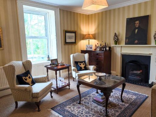 Farm for sale in Lot 1 - Dinley Farmhouse, TD9 — £575,000 • 7 bed • 1 bath • 3097 ft²
 Farm for sale in Whole - Dinley Farm, Hermitage, Newcastleton, Roxburghshire, TD9 0LT, TD9 — £2,370,000 • 7 bed • 1 bath • 1915 ft²
 2 bedroom cottage for sale in Lot 4 - Dinley Riverside Cottage, TD9 — £220,000 • 2 bed • 1 bath • 755 ft²
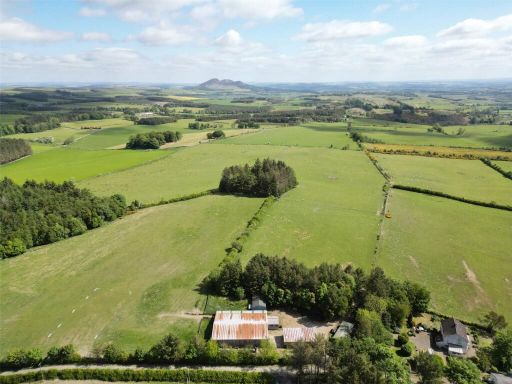 Land for sale in Friarshawmuir Farm, Selkirk, Scottish Borders, TD7 — £1,050,000 • 4 bed • 2 bath • 2093 ft²
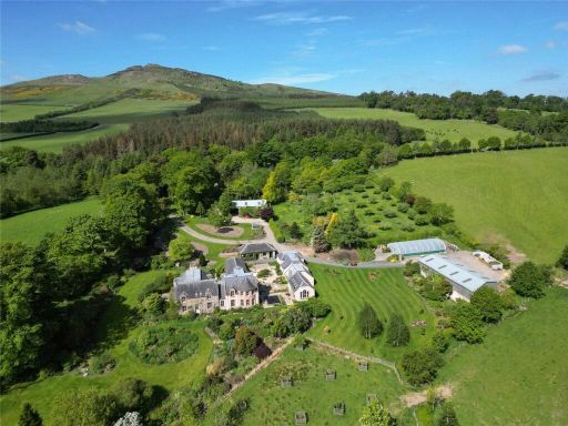 Land for sale in Lot 1 West Leas, Denholm, Scottish Borders, TD9 — £1,395,000 • 4 bed • 1 bath • 5200 ft²
Meta
- {
"@context": "https://schema.org",
"@type": "Residence",
"name": "Farm land for sale in Lot 2 Land at Dinley, TD9",
"description": "",
"url": "https://propertypiper.co.uk/property/77385275-5e45-4d30-9ffa-a122a78d506c",
"image": "https://image-a.propertypiper.co.uk/73cf617a-8f10-4df0-8c8e-f91974afb51b-1024.jpeg",
"address": {
"@type": "PostalAddress",
"streetAddress": "2 OLD BRAIDLIE COTTAGES, HAWICK",
"postalCode": "TD9 0LT",
"addressLocality": "Scottish Borders",
"addressRegion": "Berwickshire, Roxburgh and Selkirk",
"addressCountry": "Scotland"
},
"geo": {
"@type": "GeoCoordinates",
"latitude": 55.2645598,
"longitude": -2.8234144
},
"numberOfRooms": 1,
"numberOfBathroomsTotal": 1,
"floorSize": {
"@type": "QuantitativeValue",
"value": 1915,
"unitCode": "FTK"
},
"offers": {
"@type": "Offer",
"price": 650000,
"priceCurrency": "GBP",
"availability": "https://schema.org/InStock"
},
"additionalProperty": [
{
"@type": "PropertyValue",
"name": "Feature",
"value": "rural"
},
{
"@type": "PropertyValue",
"name": "Feature",
"value": "farmhouse"
},
{
"@type": "PropertyValue",
"name": "Feature",
"value": "barn"
},
{
"@type": "PropertyValue",
"name": "Feature",
"value": "isolation"
},
{
"@type": "PropertyValue",
"name": "Feature",
"value": "scenic"
},
{
"@type": "PropertyValue",
"name": "Feature",
"value": "rolling hills"
},
{
"@type": "PropertyValue",
"name": "Feature",
"value": "country living"
},
{
"@type": "PropertyValue",
"name": "Feature",
"value": "agriculture"
},
{
"@type": "PropertyValue",
"name": "Feature",
"value": "expansive land"
},
{
"@type": "PropertyValue",
"name": "Feature",
"value": "detached property"
},
{
"@type": "PropertyValue",
"name": "Feature",
"value": "landscape views"
},
{
"@type": "PropertyValue",
"name": "Feature",
"value": "privacy"
},
{
"@type": "PropertyValue",
"name": "Feature",
"value": "rural"
},
{
"@type": "PropertyValue",
"name": "Feature",
"value": "estate"
},
{
"@type": "PropertyValue",
"name": "Feature",
"value": "large plot"
},
{
"@type": "PropertyValue",
"name": "Feature",
"value": "agricultural"
},
{
"@type": "PropertyValue",
"name": "Feature",
"value": "countryside"
},
{
"@type": "PropertyValue",
"name": "Feature",
"value": "barn"
},
{
"@type": "PropertyValue",
"name": "Feature",
"value": "farm"
},
{
"@type": "PropertyValue",
"name": "Feature",
"value": "secluded"
},
{
"@type": "PropertyValue",
"name": "Feature",
"value": "fields"
},
{
"@type": "PropertyValue",
"name": "Feature",
"value": "land"
}
]
}