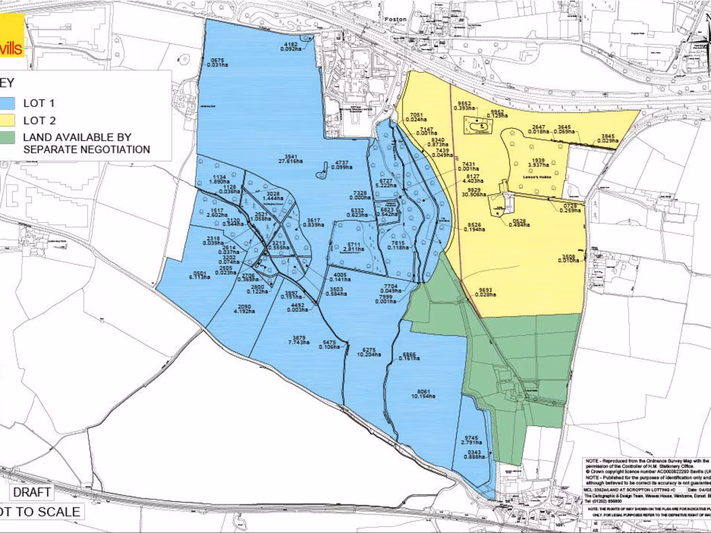
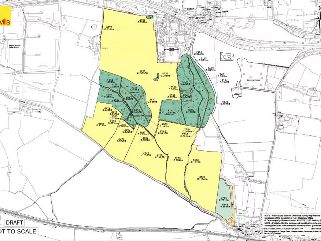
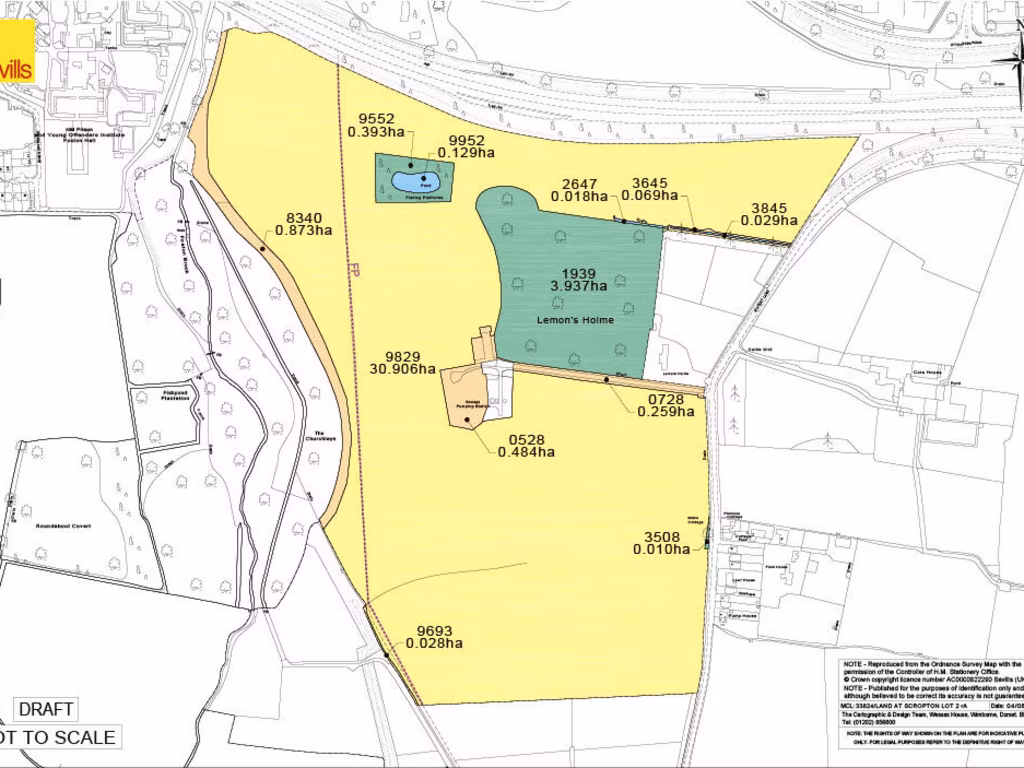
DE65 5PL - Land for sale in Watery Lane, Scropton, Derby, Derbyshire,…
View on Property Piper
Land for sale in Watery Lane, Scropton, Derby, Derbyshire, DE65
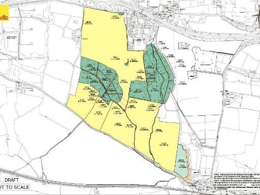
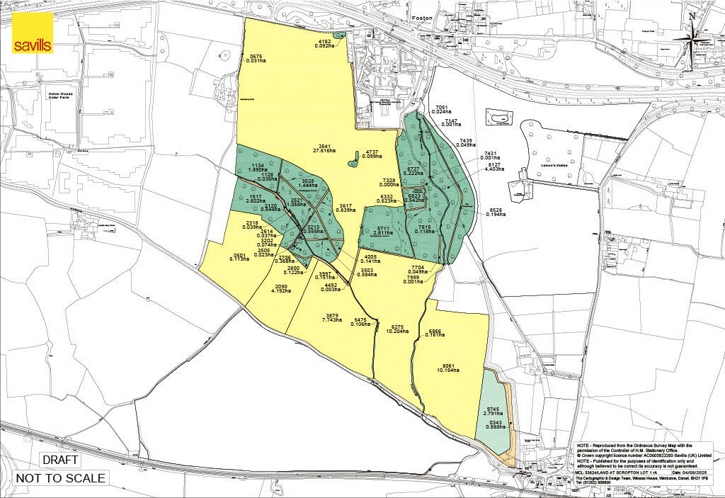
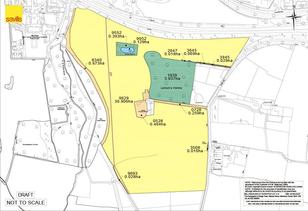
Property Details
- Price: £2425000
- Bedrooms: 1
- Bathrooms: 1
- Property Type: undefined
- Property SubType: undefined
Image Descriptions
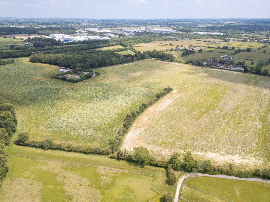
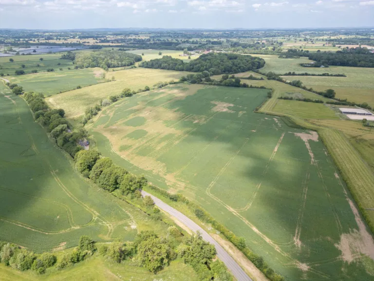
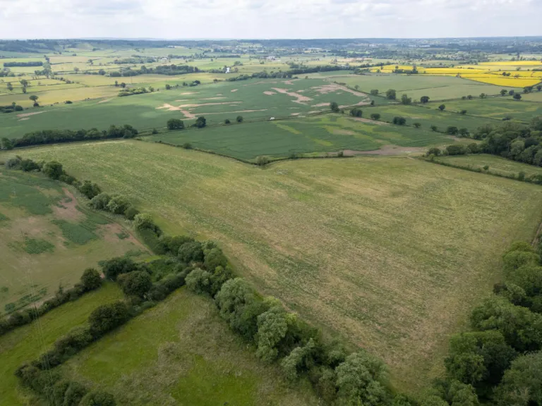
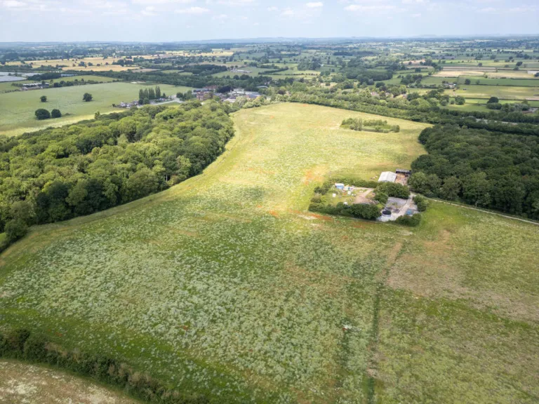
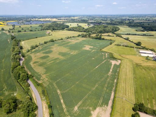
- rural land
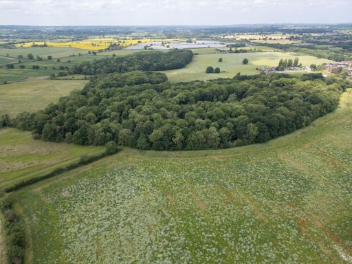
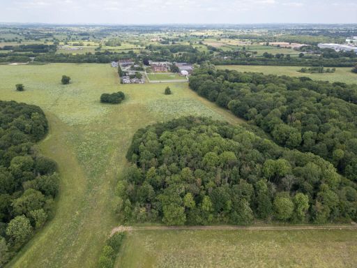
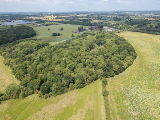
- vast land natural woodland
Textual Property Features
Detected Visual Features
- rural land
- field
- agriculture
- countryside
- open space
- expanse
- potential development
- woodland
- rural
- vast land
- nature
- trees
- investment
- undeveloped
Nearby Schools
- Shobnall Primary & Nursery School
- Henhurst Ridge Primary Academy
- Victoria Community School
- Outwoods Primary School
- William Shrewsbury Primary School
- Longford CofE Primary School
- Scientia Academy
- The Mosley Academy
- The de Ferrers Academy
- John of Rolleston Primary School
- St Augustine's CofE Academy
- The Mease Spencer Academy
- Hilton Spencer Academy
- All Saints CofE (C) Primary School
- Horninglow Primary: A de Ferrers Trust Academy
- St Modwen's Catholic Primary School
- Heath Fields Primary School
- Sudbury Primary School
- Marston Montgomery Primary School
- Grange School
- Lansdowne: A de Ferrers Trust Academy
- Eton Park Junior: A de Ferrers Trust Academy
- Needwood CofE Primary School
- Burton Fields School
- Richard Wakefield CofE Primary Academy
- Church Broughton CofE Primary School
Nearest General Shops
- Id: 4380283584
- Tags:
- Name: Bestall's (Hatton)
- Shop: hardware
- TagsNormalized:
- Lat: 52.8688384
- Lon: -1.6799722
- FullGeoHash: gcqucb2xmccc
- PartitionGeoHash: gcqu
- Images:
- FoodStandards: null
- Distance: 2389.7
,- Id: 131855190
- Tags:
- Name: Hatton Buildbase
- Shop: trade
- Source: Bing;survey
- Trade: building_supplies
- Website: https://www.buildbase.co.uk/
- TagsNormalized:
- Lat: 52.8641906
- Lon: -1.6842251
- FullGeoHash: gcqu9xts4xqs
- PartitionGeoHash: gcqu
- Images:
- FoodStandards: null
- Distance: 2364.3
,- Id: 941732933
- Tags:
- Addr:
- City: Derby
- Postcode: DE65 5DT
- Street: Scropton Road
- Village: Hatton
- Building: industrial
- Contact:
- Email: info@hattongarage.com
- Phone: +44 1332 844 009
- Website: https://www.hattongarage.com/
- Name: Hatton Garage
- Shop: car_repair
- TagsNormalized:
- industrial
- garage
- car repair
- repair
- shop
- Lat: 52.8654247
- Lon: -1.6843184
- FullGeoHash: gcqu9xve2t3j
- PartitionGeoHash: gcqu
- Images:
- FoodStandards: null
- Distance: 2285.8
}
Nearest Religious buildings
- Id: 416069327
- Tags:
- Addr:
- City: Derby
- Postcode: DE65 5EL
- Street: Station Road
- Village: Hatton
- Amenity: place_of_worship
- Building: church
- Denomination: anglican
- Name: All Saints, Hatton
- Religion: christian
- Wikidata: Q105086311
- TagsNormalized:
- place of worship
- church
- anglican
- christian
- Lat: 52.8672902
- Lon: -1.6809792
- FullGeoHash: gcquc8pyq35n
- PartitionGeoHash: gcqu
- Images:
- FoodStandards: null
- Distance: 2390.1
,- Id: 1127512542
- Tags:
- Addr:
- City: Derby
- Postcode: DE65 5DS
- Street: Scropton Road
- Village: Hatton
- Amenity: place_of_worship
- Denomination: methodist
- Name: Hatton Methodist Church
- Religion: christian
- TagsNormalized:
- place of worship
- methodist
- church
- christian
- Lat: 52.8653864
- Lon: -1.6835964
- FullGeoHash: gcqu9xy51q79
- PartitionGeoHash: gcqu
- Images:
- FoodStandards: null
- Distance: 2329.7
,- Id: 405328453
- Tags:
- Addr:
- City: Derby
- Postcode: DE65 5PN
- Street: Scropton Road
- Village: Scropton
- Amenity: place_of_worship
- Building: church
- Denomination: anglican
- Name: St Paul, Scropton
- Religion: christian
- Wikidata: Q26388823
- TagsNormalized:
- place of worship
- church
- anglican
- paul
- christian
- Lat: 52.8688306
- Lon: -1.7148296
- FullGeoHash: gcqubbrr3866
- PartitionGeoHash: gcqu
- Images:
- FoodStandards: null
- Distance: 796.5
}
Nearest Medical buildings
- Id: 29182729
- Tags:
- Amenity: hospital
- Healthcare: hospital
- Landuse: healthcare
- Name: Outwood Site
- TagsNormalized:
- Lat: 52.8204865
- Lon: -1.6592825
- FullGeoHash: gcqu6pxtxum7
- PartitionGeoHash: gcqu
- Images:
- FoodStandards: null
- Distance: 7164.5
,- Id: 943313187
- Tags:
- Addr:
- City: Burton-on-Trent
- Country: GB
- Housenumber: 59
- Postcode: DE13 9NA
- Street: Monk Street
- Village: Tutbury
- Amenity: dentist
- Brand: Bupa
- Brand:wikidata: Q931628
- Brand:wikipedia: en:Bupa
- Building: yes
- Building:levels: 2
- Contact:
- Website: https://www.bupa.co.uk/dental/dental-care/practices/tutbury
- Healthcare: dentist
- Name: Bupa Dental Care
- TagsNormalized:
- dentist
- bupa
- health
- healthcare
- dental
- Lat: 52.8580017
- Lon: -1.6863433
- FullGeoHash: gcqu9ws01mem
- PartitionGeoHash: gcqu
- Images:
- FoodStandards: null
- Distance: 2706.4
,- Id: 131855196
- Tags:
- Amenity: doctors
- Building: yes
- Healthcare: doctor
- Name: Tutbury Health Centre
- Source: Bing;survey
- TagsNormalized:
- doctor
- doctors
- health
- healthcare
- health centre
- Lat: 52.8578902
- Lon: -1.6874475
- FullGeoHash: gcqu9w7px8gu
- PartitionGeoHash: gcqu
- Images:
- FoodStandards: null
- Distance: 2666.2
,- Id: 4380283587
- Tags:
- Addr:
- City: Derby
- Postcode: DE65 5EL
- Street: Station Road
- Village: Hatton
- Amenity: post_office
- Dispensing: yes
- Healthcare: pharmacy
- Name: Good Life Pharmacy
- Pharmacy: yes
- Ref:
- TagsNormalized:
- office
- post office
- pharmacy
- health
- healthcare
- Lat: 52.8666305
- Lon: -1.6806996
- FullGeoHash: gcqucb04ky5w
- PartitionGeoHash: gcqu
- Images:
- FoodStandards: null
- Distance: 2437.6
}
Nearest Airports
- Id: 11359528
- Tags:
- Aerodrome: international
- Aerodrome:type: public
- Aeroway: aerodrome
- Iata: EMA
- Icao: EGNX
- Is_in: Castle Donington,England,UK
- Name: East Midlands Airport
- Old_name: RAF Castle Donington
- Operator: Manchester Airports Holdings Limited
- Operator:type: private
- Ref: EMA
- Type: multipolygon
- Website: https://www.eastmidlandsairport.com/
- Wikidata: Q8977
- Wikipedia: en:East Midlands Airport
- TagsNormalized:
- airport
- international airport
- Lat: 52.8281122
- Lon: -1.3322143
- FullGeoHash: gcrh99jfj1vh
- PartitionGeoHash: gcrh
- Images:
- FoodStandards: null
- Distance: 26153.9
}
Nearest Leisure Facilities
- Id: 701519659
- Tags:
- TagsNormalized:
- Lat: 52.8663289
- Lon: -1.717076
- FullGeoHash: gcqubbj8tjzr
- PartitionGeoHash: gcqu
- Images:
- FoodStandards: null
- Distance: 1095.8
,- Id: 302429929
- Tags:
- Leisure: pitch
- Sport: soccer
- TagsNormalized:
- Lat: 52.8809856
- Lon: -1.7255094
- FullGeoHash: gcqubdxw0dny
- PartitionGeoHash: gcqu
- Images:
- FoodStandards: null
- Distance: 977.3
,- Id: 762852008
- Tags:
- TagsNormalized:
- Lat: 52.8703749
- Lon: -1.7176959
- FullGeoHash: gcqubbv0qb1p
- PartitionGeoHash: gcqu
- Images:
- FoodStandards: null
- Distance: 679.3
,- Id: 762852006
- Tags:
- TagsNormalized:
- Lat: 52.8729283
- Lon: -1.7177613
- FullGeoHash: gcqubcjpjk0q
- PartitionGeoHash: gcqu
- Images:
- FoodStandards: null
- Distance: 438.5
,- Id: 762852005
- Tags:
- TagsNormalized:
- Lat: 52.8732661
- Lon: -1.717865
- FullGeoHash: gcqubcm14g5j
- PartitionGeoHash: gcqu
- Images:
- FoodStandards: null
- Distance: 415.2
}
Nearest Tourist attractions
- Id: 1127523986
- Tags:
- Addr:
- City: Tutbury
- Housename: Charity House
- Postcode: DE13 9NE
- Street: Duke Street
- Museum: local
- Name: Tutbury Museum & Information Centre
- Tourism: museum
- Website: https://www.tutburymuseum.org/
- Wikidata: Q113369658
- TagsNormalized:
- Lat: 52.8570869
- Lon: -1.6868328
- FullGeoHash: gcqu9w7dvgnk
- PartitionGeoHash: gcqu
- Images:
- FoodStandards: null
- Distance: 2760.8
,- Id: 217322605
- Tags:
- Building: yes
- Museum: history
- Ruins: yes
- Tourism: museum
- TagsNormalized:
- Lat: 52.8591536
- Lon: -1.6907391
- FullGeoHash: gcqu9w8yfumt
- PartitionGeoHash: gcqu
- Images:
- FoodStandards: null
- Distance: 2416.2
,- Id: 302429932
- Tags:
- TagsNormalized:
- Lat: 52.884934
- Lon: -1.725633
- FullGeoHash: gcqubermjf4z
- PartitionGeoHash: gcqu
- Images:
- FoodStandards: null
- Distance: 1285.5
}
Nearest Bus stations and stops
- Id: 7117322267
- Tags:
- Bus: yes
- Highway: bus_stop
- Name: Hall
- Public_transport: platform
- TagsNormalized:
- Lat: 52.8833498
- Lon: -1.7240951
- FullGeoHash: gcqubg0ecdvt
- PartitionGeoHash: gcqu
- Images:
- FoodStandards: null
- Distance: 1084.1
,- Id: 7117322270
- Tags:
- Bus: yes
- Highway: bus_stop
- Name: Dove Valley Business Park
- Public_transport: platform
- TagsNormalized:
- Lat: 52.8825434
- Lon: -1.7021721
- FullGeoHash: gcquc6bx0s86
- PartitionGeoHash: gcqu
- Images:
- FoodStandards: null
- Distance: 1059.2
,- Id: 7117322268
- Tags:
- Bus: yes
- Highway: bus_stop
- Name: Village
- Public_transport: platform
- TagsNormalized:
- Lat: 52.8836302
- Lon: -1.7222974
- FullGeoHash: gcqubg1v7x1v
- PartitionGeoHash: gcqu
- Images:
- FoodStandards: null
- Distance: 1035.3
,- Id: 7117322271
- Tags:
- Highway: bus_stop
- Name: Watery Lane
- Public_transport: platform
- TagsNormalized:
- Lat: 52.8806625
- Lon: -1.7035407
- FullGeoHash: gcquc4xs0tgy
- PartitionGeoHash: gcqu
- Images:
- FoodStandards: null
- Distance: 852.7
,- Id: 7117322269
- Tags:
- Highway: bus_stop
- Name: Brandons Poultry
- Public_transport: platform
- TagsNormalized:
- Lat: 52.8830051
- Lon: -1.7124604
- FullGeoHash: gcquc511bf8v
- PartitionGeoHash: gcqu
- Images:
- FoodStandards: null
- Distance: 787.6
}
Nearest Hotels
- Id: 421972534
- Tags:
- Addr:
- City: Burton-on-Trent
- Housenumber: 227
- Postcode: DE13 0AJ
- Street: Tutbury Road
- Amenity: pub
- Fhrs:
- Name: Beacon Hotel
- Old_fhrs:
- TagsNormalized:
- Lat: 52.8308714
- Lon: -1.652526
- FullGeoHash: gcqud3sdjk5r
- PartitionGeoHash: gcqu
- Images:
- FoodStandards: null
- Distance: 6475.3
,- Id: 615388641
- Tags:
- Building: yes
- Name: Brookhouse Hotel and Restaurant
- Tourism: hotel
- Tourism_1: restaurant
- TagsNormalized:
- Lat: 52.8472871
- Lon: -1.6466885
- FullGeoHash: gcquds8cv2k4
- PartitionGeoHash: gcqu
- Images:
- FoodStandards: null
- Distance: 5506.3
,- Id: 534386803
- Tags:
- Addr:
- Postcode: DE6 5GX
- Street: Station Road
- Amenity: restaurant
- Fhrs:
- Name: Boars Head Hotel
- Tourism: hotel
- TagsNormalized:
- Lat: 52.8739005
- Lon: -1.7605578
- FullGeoHash: gcqszcqhb12y
- PartitionGeoHash: gcqs
- Images:
- FoodStandards: null
- Distance: 3161.8
}
Tags
- rural land
- field
- agriculture
- countryside
- open space
- expanse
- potential development
- woodland
- rural
- vast land
- nature
- trees
- countryside
- agriculture
- investment
- undeveloped
- potential development
Local Market Stats
- Average Price/sqft: £259
- Avg Income: £50200
- Rental Yield: 3.2%
- Social Housing: 3%
- Planning Success Rate: 92%
Similar Properties
 Land for sale in Watery Lane, Scropton, Derby, Derbyshire, DE65 — £1,700,000 • 1 bed • 1 bath
 Land for sale in Watery Lane, Scropton, Derby, Derbyshire, DE65 — £725,000 • 1 bed • 1 bath
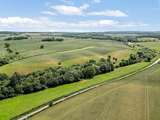 Land for sale in Derby, Derbyshire, DE65 — £3,400,000 • 1 bed • 1 bath
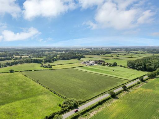 Land for sale in Hoar Cross, Burton-on-Trent, Staffordshire, DE13 — £1,215,000 • 1 bed • 1 bath
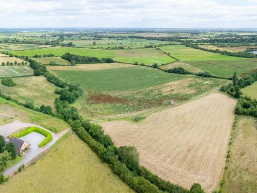 Land for sale in Land North of Kings Newton, Nr Melbourne, DE73 — £1,400,000 • 1 bed • 1 bath
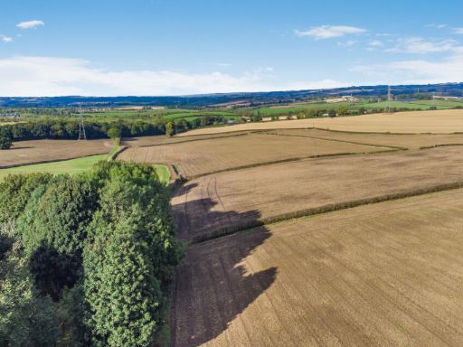 Land for sale in Rock Farm, Sutton Scarsdale, Chesterfield, Derbyshire, S44 — £360,000 • 1 bed • 1 bath • 2153 ft²
Meta
- {
"@context": "https://schema.org",
"@type": "Residence",
"name": "Land for sale in Watery Lane, Scropton, Derby, Derbyshire,…",
"description": "",
"url": "https://propertypiper.co.uk/property/72a4c33c-7810-41f3-b661-aeded41ea26d",
"image": "https://image-a.propertypiper.co.uk/6cd5810c-697c-4024-b1f4-728d81e72767-1024.jpeg",
"address": {
"@type": "PostalAddress",
"streetAddress": "Watery Lane, Scropton, Derby, Derbyshire, DE65",
"postalCode": "DE65 5PL",
"addressLocality": "South Derbyshire",
"addressRegion": "South Derbyshire",
"addressCountry": "England"
},
"geo": {
"@type": "GeoCoordinates",
"latitude": 52.8759533,
"longitude": -1.7135691
},
"numberOfRooms": 1,
"numberOfBathroomsTotal": 1,
"offers": {
"@type": "Offer",
"price": 2425000,
"priceCurrency": "GBP",
"availability": "https://schema.org/InStock"
},
"additionalProperty": [
{
"@type": "PropertyValue",
"name": "Feature",
"value": "rural land"
},
{
"@type": "PropertyValue",
"name": "Feature",
"value": "field"
},
{
"@type": "PropertyValue",
"name": "Feature",
"value": "agriculture"
},
{
"@type": "PropertyValue",
"name": "Feature",
"value": "countryside"
},
{
"@type": "PropertyValue",
"name": "Feature",
"value": "open space"
},
{
"@type": "PropertyValue",
"name": "Feature",
"value": "expanse"
},
{
"@type": "PropertyValue",
"name": "Feature",
"value": "potential development"
},
{
"@type": "PropertyValue",
"name": "Feature",
"value": "woodland"
},
{
"@type": "PropertyValue",
"name": "Feature",
"value": "rural"
},
{
"@type": "PropertyValue",
"name": "Feature",
"value": "vast land"
},
{
"@type": "PropertyValue",
"name": "Feature",
"value": "nature"
},
{
"@type": "PropertyValue",
"name": "Feature",
"value": "trees"
},
{
"@type": "PropertyValue",
"name": "Feature",
"value": "countryside"
},
{
"@type": "PropertyValue",
"name": "Feature",
"value": "agriculture"
},
{
"@type": "PropertyValue",
"name": "Feature",
"value": "investment"
},
{
"@type": "PropertyValue",
"name": "Feature",
"value": "undeveloped"
},
{
"@type": "PropertyValue",
"name": "Feature",
"value": "potential development"
}
]
}