HA7 4HL - 2 bedroom flat for sale in Albemarle Park, Stanmore, HA7
View on Property Piper
2 bedroom flat for sale in Albemarle Park, Stanmore, HA7
Property Details
- Price: £450000
- Bedrooms: 2
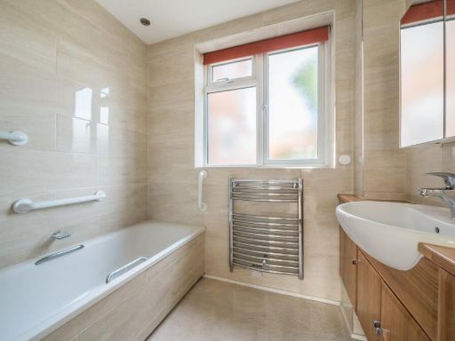
- Bathrooms: 1
- Property Type: undefined
- Property SubType: undefined
Brochure Descriptions
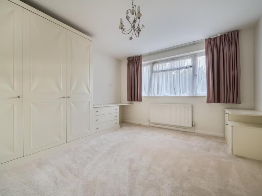
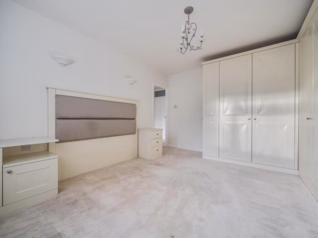
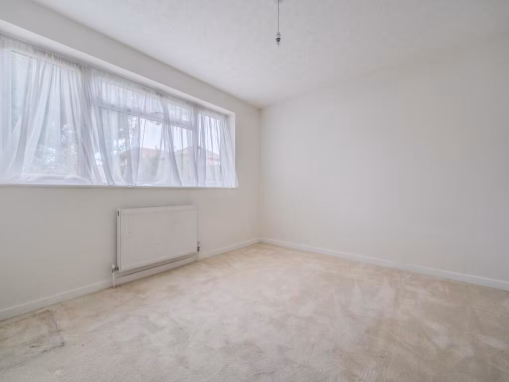
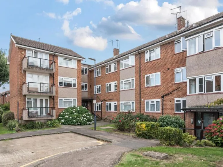
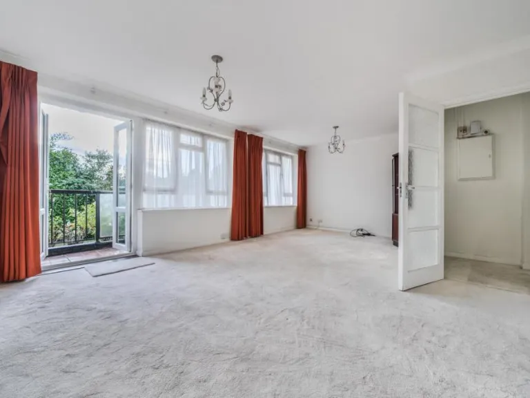
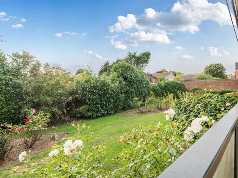
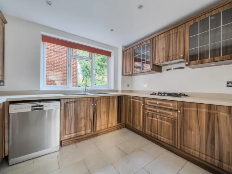
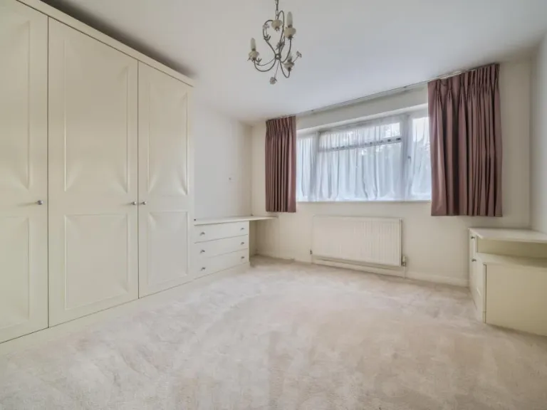
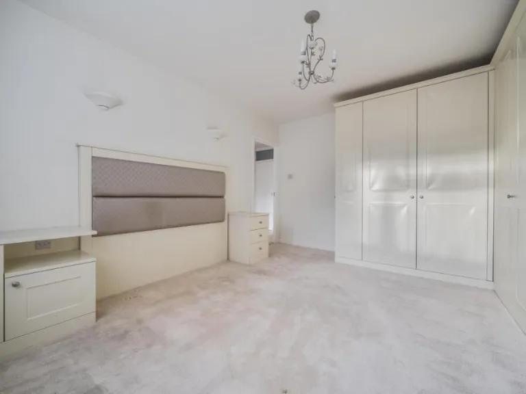
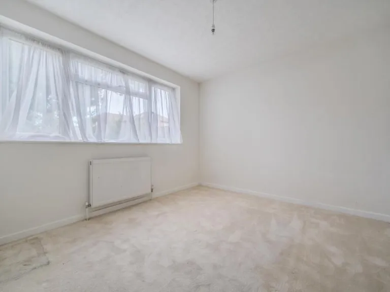
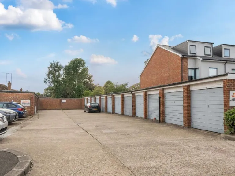
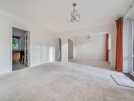
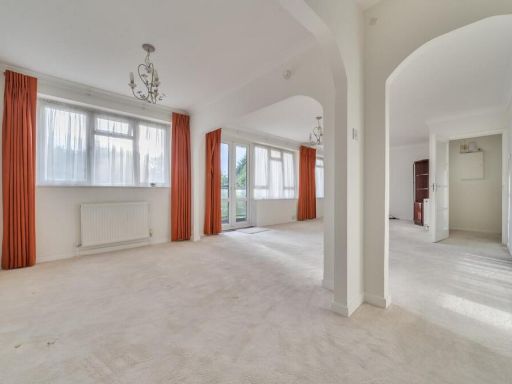
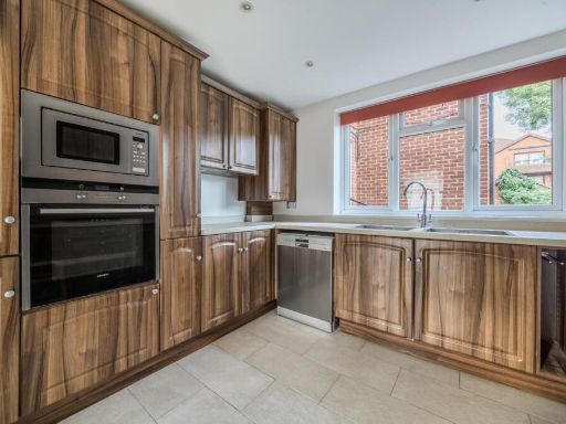
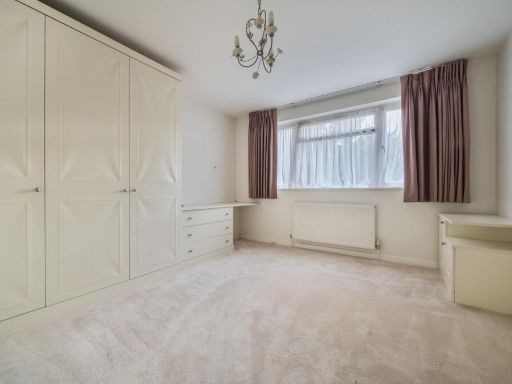
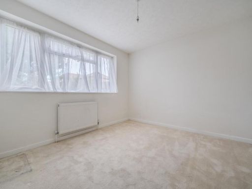
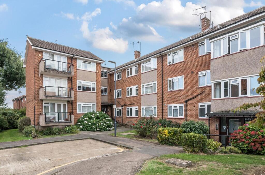
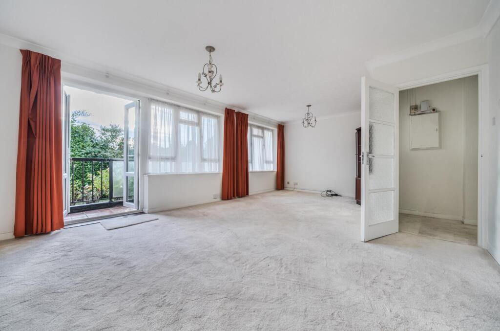
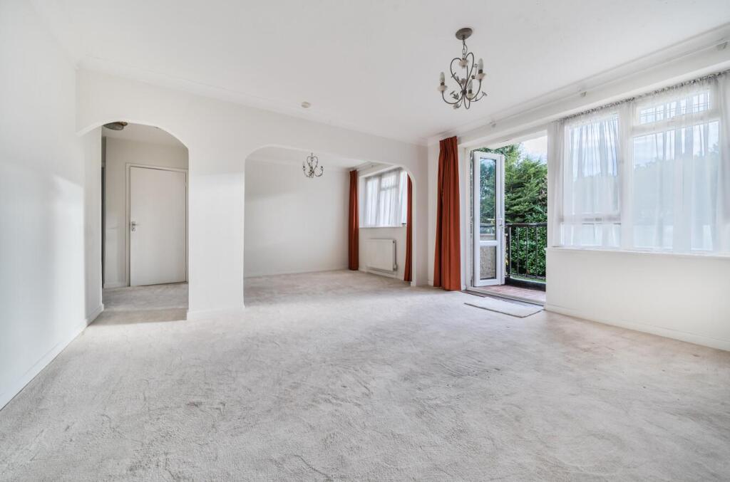
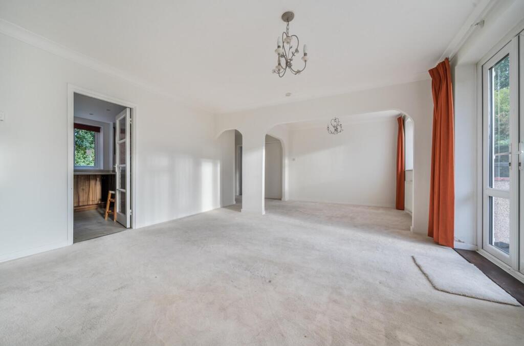
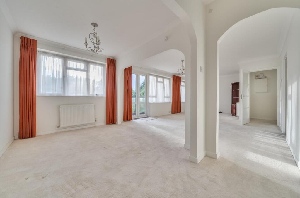
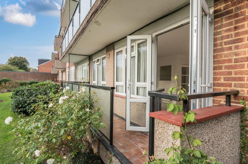
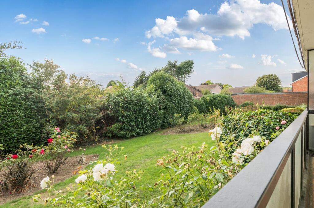
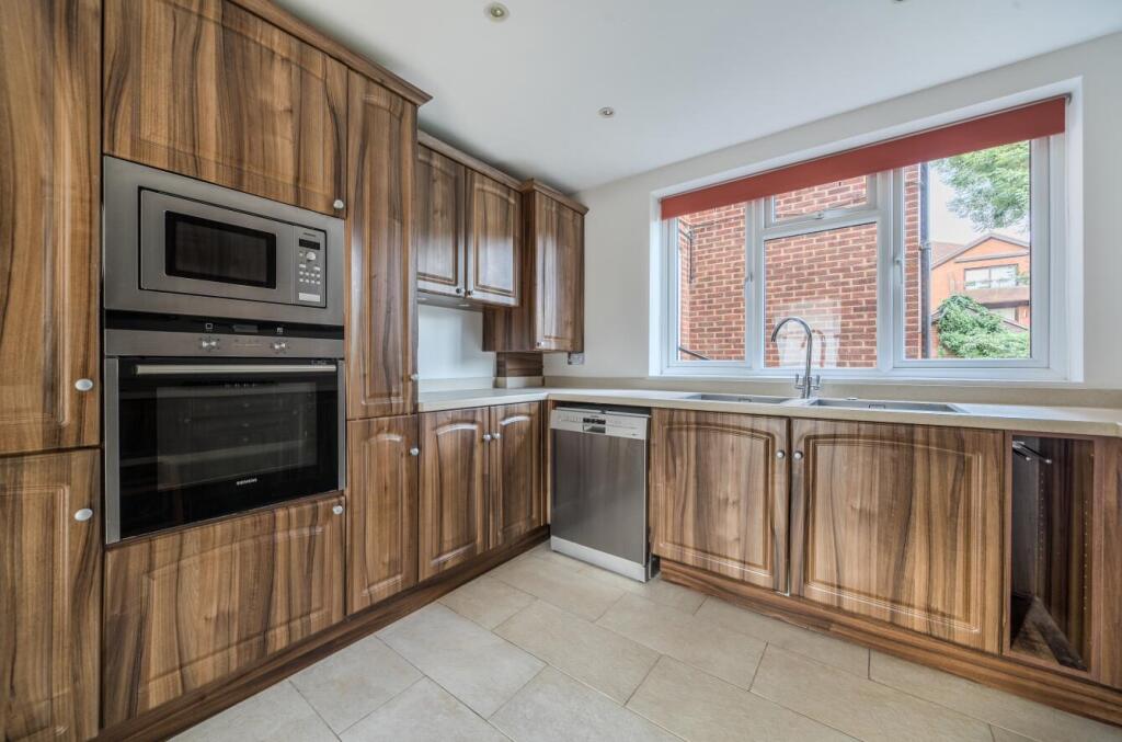
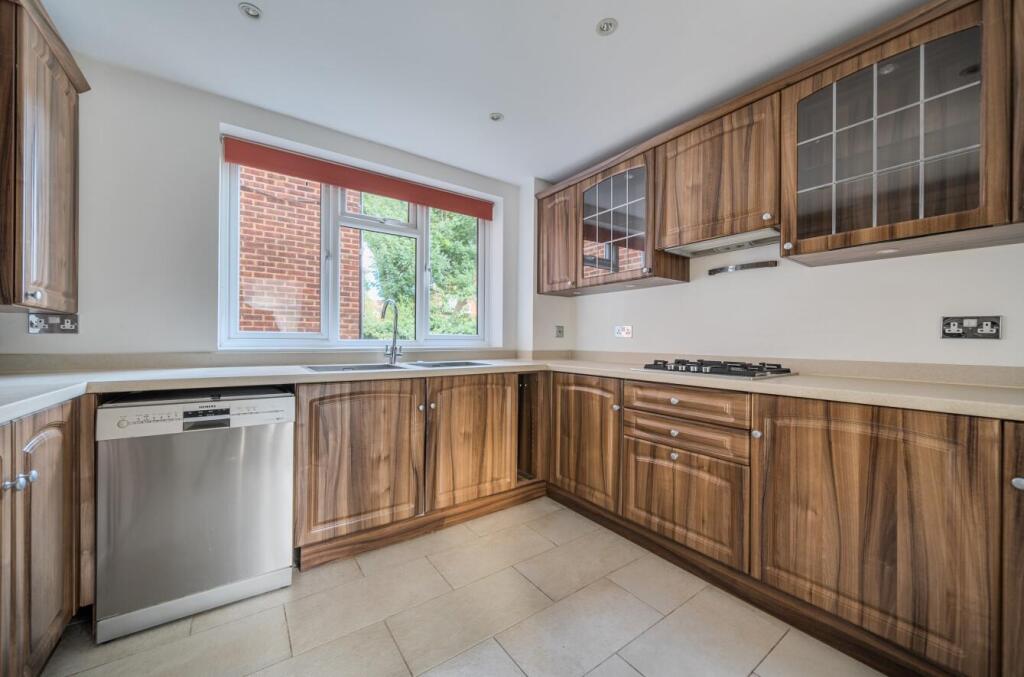
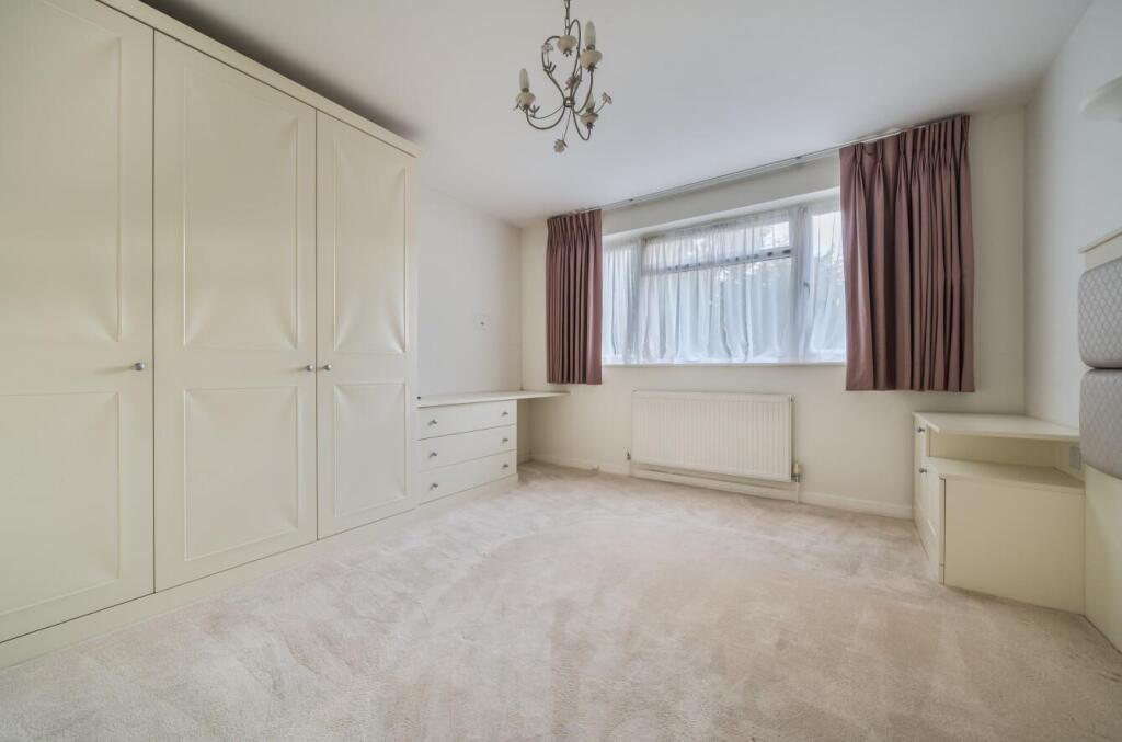
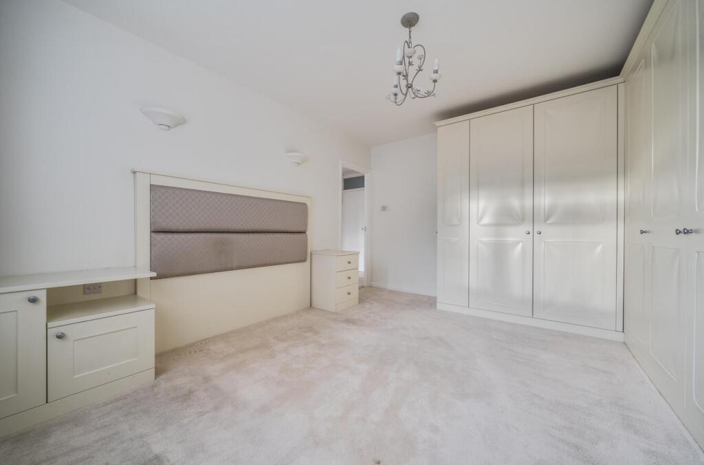
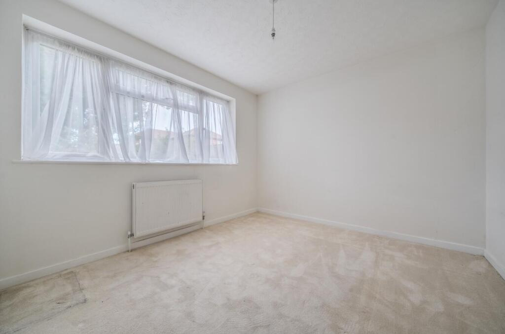
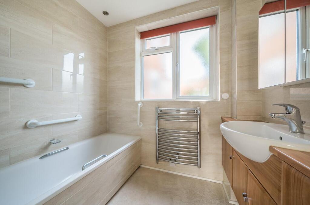
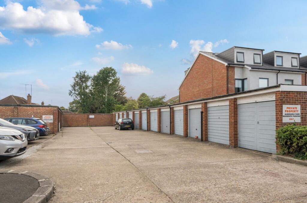
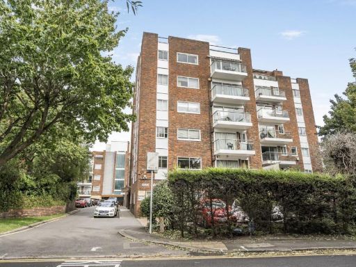
- First-floor (third-floor by some numbering) two-bedroom purpose-built flat in a low-rise block set in established communal gardens. The property presents as a spacious apartment with a long reception room (nearly 30' noted), separate kitchen, master bedroom with fitted wardrobes, second double bedroom, family bathroom and separate WC. Benefits include a private west-facing balcony, single garage en bloc and leasehold tenure. Listed chain-free and described in good condition throughout. Grounds appear well-maintained with mature planting and on-site parking. Overall size is typical of a two-bedroom apartment in this type of 1960s/1970s block — medium-sized internal accommodation with average communal amenity provision.
- Ground-floor two-bedroom apartment in Stanmore presented as a well-proportioned suburban property. Accommodation comprises a generous reception / dining room with access to a balcony overlooking a mature rear garden, a modern fitted kitchen with built-in appliances, two double bedrooms (one with fitted wardrobes), and a bathroom. The unit benefits from good natural light and pleasant garden views to the rear. EPC shown as current 74 (C) with a potential 77. Overall plot/garden is of average size for the area; the apartment itself is small-to-medium in total internal area and suitable for a couple or small family seeking a suburban flat with outside space.
Image Descriptions
- apartment complex mid-century
- living room Mid-20th century
Floorplan Description
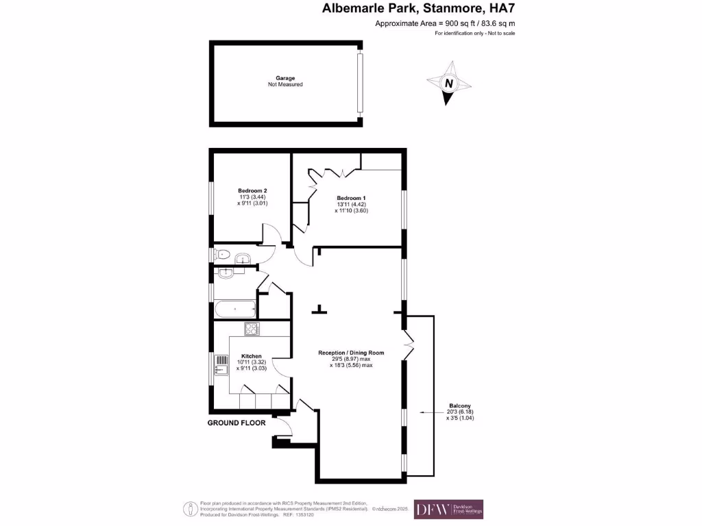
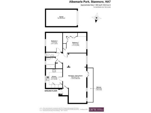
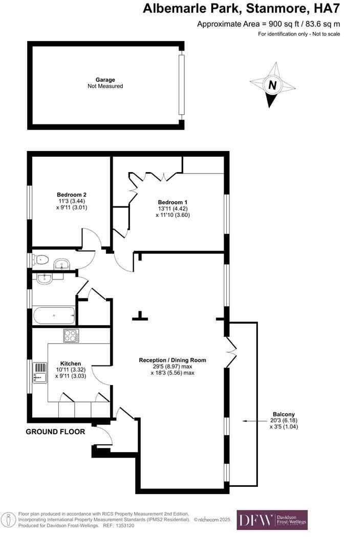
- Ground floor plan showing two bedrooms, kitchen and reception/dining room.
Rooms
- Bedroom 1:
- Bedroom 2:
- Kitchen:
- Reception / Dining Room:
- Balcony:
Textual Property Features
Detected Visual Features
- apartment complex
- mid-century
- brick facade
- balconies
- three-story
- landscaped garden
- communal areas
- living room
- mid-20th century
- natural light
- dated decor
- chandelier lighting
- balcony access
- maintenance needed
- potential modernisation
- unappealing carpet
- spacious layout
EPC Details
- Fully double glazed
- Cavity wall, filled cavity
- Boiler and radiators, mains gas
- Low energy lighting in all fixed outlets
- Solid, no insulation (assumed)
Nearby Schools
- Elmgrove Primary School & Nursery
- Kenmore Park Junior School
- Belmont School
- Avanti House School
- North London Collegiate School
- Kenmore Park Infant and Nursery School
- The Sacred Heart Language College
- Hujjat Primary School
- Bentley Wood High School
- St Nicholas Elstree Church of England VA Primary School
- St Bernadette's Catholic Primary School
- Priestmead Primary School and Nursery
- St Joseph's Catholic Primary School
- Park High School
- Camrose Primary With Nursery
- Krishna Avanti Primary School
- Stanburn Primary School
- London Academy
- Glebe Primary School
- Canons High School
- Stag Lane Primary School
- Weald Rise Primary School
- Whitchurch Primary School & Nursery
- Aylward Primary School
- St John's CofE School
- Tashbar of Edgware
- Avanti House Primary School
Nearest Bars And Restaurants
- Id: 436249452
- Tags:
- Amenity: restaurant
- Building: yes
- Cuisine: asian
- Diet:
- Name: Spice Rack
- Takeaway: yes
- TagsNormalized:
- restaurant
- asian
- vegetarian
- takeaway
- Lat: 51.6172029
- Lon: -0.3130169
- FullGeoHash: gcpv8ush40j8
- PartitionGeoHash: gcpv
- Images:
- FoodStandards: null
- Distance: 373.4
,- Id: 5141526020
- Tags:
- Amenity: fast_food
- Brand: Subway
- Brand:wikidata: Q244457
- Brand:wikipedia: en:Subway (restaurant)
- Contact:
- Website: https://restaurants.subway.com/united-kingdom/en/london/42-church-road
- Cuisine: sandwich
- Level: 0
- Name: Subway
- Takeaway: yes
- TagsNormalized:
- fast food
- food
- sandwich
- takeaway
- Lat: 51.6167514
- Lon: -0.3132209
- FullGeoHash: gcpv8uecm7ve
- PartitionGeoHash: gcpv
- Images:
- FoodStandards: null
- Distance: 371.2
,- Id: 5141528233
- Tags:
- Amenity: restaurant
- Cuisine: lebanese
- Level: 0
- Name: Sahara Lounge
- Outdoor_seating: yes
- TagsNormalized:
- Lat: 51.6179165
- Lon: -0.3119207
- FullGeoHash: gcpv8uub5tp1
- PartitionGeoHash: gcpv
- Images:
- FoodStandards: null
- Distance: 348.4
,- Id: 249249967
- Tags:
- Amenity: restaurant
- Brand: Nando's
- Brand:wikidata: Q3472954
- Brand:wikipedia: en:Nando's
- Cuisine: chicken;portuguese
- Name: Nando's
- Toilets: yes
- Toilets:access: customers
- Website: https://www.nandos.co.uk/restaurants/stanmore
- TagsNormalized:
- Lat: 51.6178616
- Lon: -0.3110722
- FullGeoHash: gcpv8utrz6zf
- PartitionGeoHash: gcpv
- Images:
- FoodStandards: null
- Distance: 300.8
,- Id: 5261912103
- Tags:
- Amenity: restaurant
- Brand: Prezzo
- Brand:wikidata: Q7242489
- Brand:wikipedia: en:Prezzo (restaurant)
- Cuisine: italian
- Name: Prezzo
- TagsNormalized:
- Lat: 51.6177255
- Lon: -0.3084022
- FullGeoHash: gcpv8uxrj9qw
- PartitionGeoHash: gcpv
- Images:
- FoodStandards: null
- Distance: 200.4
}
Nearest General Shops
- Id: 5141528228
- Tags:
- Name: Mark G Hairdressing
- Shop: hairdresser
- TagsNormalized:
- Lat: 51.6180421
- Lon: -0.3088909
- FullGeoHash: gcpv8uz0fk6q
- PartitionGeoHash: gcpv
- Images:
- FoodStandards: null
- Distance: 241.6
,- Id: 5141528236
- Tags:
- Level: 0
- Name: Sophia Jewellers
- Shop: jewelry
- TagsNormalized:
- Lat: 51.6178227
- Lon: -0.3094659
- FullGeoHash: gcpv8uwxsgtd
- PartitionGeoHash: gcpv
- Images:
- FoodStandards: null
- Distance: 232.4
,- Id: 5141528237
- Tags:
- Addr:
- Housenumber: 50
- Street: The Broadway
- Brand: Card Factory
- Brand:wikidata: Q5038192
- Brand:wikipedia: en:Card Factory
- Level: 0
- Name: Card Factory
- Shop: gift
- TagsNormalized:
- Lat: 51.6178374
- Lon: -0.3093987
- FullGeoHash: gcpv8uwxwqr9
- PartitionGeoHash: gcpv
- Images:
- FoodStandards: null
- Distance: 231.9
}
Nearest Grocery shops
- Id: 325254582
- Tags:
- Addr:
- City: Edgware
- Housenumber: 14-15
- Postcode: HA8 6RW
- Street: Station Parade
- Atm: yes
- Branch: Canons Park Express
- Brand: Tesco Express
- Brand:wikidata: Q98456772
- Brand:wikipedia: en:Tesco
- Building: yes
- Building:levels: 3
- Contact:
- Website: https://www.tesco.com/store-locator/edgware/16-18-station-parade
- Name: Tesco Express
- Opening_hours: Mo-Su 06:00-23:00
- Shop: convenience
- TagsNormalized:
- atm
- tesco
- tesco express
- convenience
- shop
- Lat: 51.6076836
- Lon: -0.2961324
- FullGeoHash: gcpv96bke9e8
- PartitionGeoHash: gcpv
- Images:
- FoodStandards: null
- Distance: 1230.8
,- Id: 2376007896
- Tags:
- Addr:
- Housenumber: 861
- Postcode: HA7 1AR
- Street: Honeypot Lane
- Name: Honeypot Stores
- Shop: convenience
- TagsNormalized:
- Lat: 51.6062187
- Lon: -0.3008121
- FullGeoHash: gcpv94sun86j
- PartitionGeoHash: gcpv
- Images:
- FoodStandards: null
- Distance: 1189.6
,- Id: 5141528231
- Tags:
- Brand: Spar
- Brand:wikidata: Q610492
- Name: Spar
- Shop: convenience
- TagsNormalized:
- Lat: 51.6213898
- Lon: -0.2935306
- FullGeoHash: gcpv9m6k2hx8
- PartitionGeoHash: gcpv
- Images:
- FoodStandards: null
- Distance: 1168.7
}
Nearest Religious buildings
- Id: 202707
- Tags:
- Name: Stanmore Church
- Naptan:
- StopAreaCode: 490G00012564
- StopAreaType: GCLS
- Verified: no
- Public_transport: stop_area
- Type: public_transport
- TagsNormalized:
- Lat: 51.6163524
- Lon: -0.3149535
- FullGeoHash: gcpv8u6xj13x
- PartitionGeoHash: gcpv
- Images:
- FoodStandards: null
- Distance: 481.9
,- Id: 526348248
- Tags:
- Amenity: place_of_worship
- Denomination: roman_catholic
- Name: St William of York
- Religion: christian
- Wikidata: Q26672485
- TagsNormalized:
- place of worship
- catholic
- roman catholic
- christian
- church
- Lat: 51.6138179
- Lon: -0.3040343
- FullGeoHash: gcpv9h4873p8
- PartitionGeoHash: gcpv
- Images:
- FoodStandards: null
- Distance: 361.7
,- Id: 94835405
- Tags:
- Amenity: place_of_worship
- Building: yes
- Denomination: evangelical
- Name: Stanmore Chapel
- Postal_code: HA7 4HP
- Religion: christian
- Source: OS;web
- Url: http://www.facebook.com/group.php?gid=2409489145
- TagsNormalized:
- place of worship
- evangelical
- chapel
- christian
- church
- Lat: 51.6143914
- Lon: -0.3065197
- FullGeoHash: gcpv9h0g9efm
- PartitionGeoHash: gcpv
- Images:
- FoodStandards: null
- Distance: 200.4
}
Nearest Medical buildings
- Id: 325254487
- Tags:
- Addr:
- Housenumber: 11
- Street: Station Parade
- Amenity: pharmacy
- Building: yes
- Levels: 3
- Name: Canons Pharmacy
- TagsNormalized:
- Lat: 51.6076463
- Lon: -0.2958413
- FullGeoHash: gcpv96bs66s9
- PartitionGeoHash: gcpv
- Images:
- FoodStandards: null
- Distance: 1247.4
,- Id: 411306150
- Tags:
- TagsNormalized:
- Lat: 51.62151
- Lon: -0.2929249
- FullGeoHash: gcpv9m6tn6gm
- PartitionGeoHash: gcpv
- Images:
- FoodStandards: null
- Distance: 1211.4
,- Id: 2376007893
- Tags:
- Amenity: pharmacy
- Healthcare: pharmacy
- Name: Kings Pharmacy
- TagsNormalized:
- Lat: 51.6065385
- Lon: -0.3010454
- FullGeoHash: gcpv94svchh3
- PartitionGeoHash: gcpv
- Images:
- FoodStandards: null
- Distance: 1150.6
,- Id: 857260295
- Tags:
- Amenity: clinic
- Building: yes
- Healthcare: clinic
- Name: Stanmore Park Medical Centre
- TagsNormalized:
- Lat: 51.6148728
- Lon: -0.3189453
- FullGeoHash: gcpv8spy2j9j
- PartitionGeoHash: gcpv
- Images:
- FoodStandards: null
- Distance: 764.6
}
Nearest Airports
- Id: 121158889
- Tags:
- Aerodrome: continental
- Aeroway: aerodrome
- Fhrs:
- Authority: City of London Corporation
- Iata: LCY
- Icao: EGLC
- Name: London City Airport
- Operator: London City Airport Limited
- Ref: LCY
- Website: https://www.londoncityairport.com/
- Wikidata: Q8982
- Wikipedia: en:London City Airport
- TagsNormalized:
- airport
- continental airport
- Lat: 51.5042658
- Lon: 0.0539987
- FullGeoHash: u10j10p64702
- PartitionGeoHash: u10j
- Images:
- FoodStandards: null
- Distance: 27936.5
,- Id: 14001268
- Tags:
- Access: yes
- Aerodrome: international
- Aerodrome:type: public
- Aeroway: aerodrome
- Alt_name: London Heathrow
- Alt_name_2: London Heathrow Airport
- Ele: 25
- Iata: LHR
- Icao: EGLL
- Int_name: Heathrow Airport
- Name: London Heathrow Airport
- Note: area still approx
- Old_name: London Airport
- Operator: Heathrow Airport Limited
- Rank_aci:
- Ref: LHR
- Short_name: Heathrow
- Type: multipolygon
- Website: https://www.heathrow.com/
- Wikidata: Q8691
- Wikipedia: en:Heathrow Airport
- TagsNormalized:
- airport
- international airport
- Lat: 51.4677522
- Lon: -0.4547736
- FullGeoHash: gcpsv9kv7h2h
- PartitionGeoHash: gcps
- Images:
- FoodStandards: null
- Distance: 19353
}
Nearest Leisure Facilities
- Id: 23116488
- Tags:
- TagsNormalized:
- Lat: 51.6197131
- Lon: -0.3118279
- FullGeoHash: gcpv8vhftguq
- PartitionGeoHash: gcpv
- Images:
- FoodStandards: null
- Distance: 495.7
,- Id: 23116469
- Tags:
- Created_by: Potlatch 0.7b
- Layer: -1
- Leisure: park
- TagsNormalized:
- Lat: 51.6196145
- Lon: -0.3120511
- FullGeoHash: gcpv8vhf09tf
- PartitionGeoHash: gcpv
- Images:
- FoodStandards: null
- Distance: 494.9
,- Id: 23116480
- Tags:
- Created_by: Potlatch 0.7b
- Leisure: pitch
- Sport: bowls
- TagsNormalized:
- Lat: 51.6200248
- Lon: -0.3103002
- FullGeoHash: gcpv8vnh3qp6
- PartitionGeoHash: gcpv
- Images:
- FoodStandards: null
- Distance: 481
,- Id: 45959759
- Tags:
- Leisure: pitch
- Sport: tennis
- TagsNormalized:
- Lat: 51.6177137
- Lon: -0.3135548
- FullGeoHash: gcpv8uewvxhx
- PartitionGeoHash: gcpv
- Images:
- FoodStandards: null
- Distance: 430.9
,- Id: 873092921
- Tags:
- Leisure: garden
- Name: Bernays Gardens
- TagsNormalized:
- Lat: 51.6160285
- Lon: -0.3137319
- FullGeoHash: gcpv8u7t1t0e
- PartitionGeoHash: gcpv
- Images:
- FoodStandards: null
- Distance: 395.5
}
Nearest Tourist attractions
- Id: 198518945
- Tags:
- Name: Watling Farm Caravan Site
- Tourism: caravan_site
- TagsNormalized:
- Lat: 51.6347211
- Lon: -0.3046321
- FullGeoHash: gcpv9pf4j99u
- PartitionGeoHash: gcpv
- Images:
- FoodStandards: null
- Distance: 2101.3
,- Id: 2906465526
- Tags:
- TagsNormalized:
- Lat: 51.6265034
- Lon: -0.3182236
- FullGeoHash: gcpv8y260vg2
- PartitionGeoHash: gcpv
- Images:
- FoodStandards: null
- Distance: 1370.2
,- Id: 2906465514
- Tags:
- TagsNormalized:
- Lat: 51.625767
- Lon: -0.3184532
- FullGeoHash: gcpv8y0jgs2p
- PartitionGeoHash: gcpv
- Images:
- FoodStandards: null
- Distance: 1309.3
}
Nearest Hotels
- Id: 95499625
- Tags:
- Amenity: restaurant
- Former_name: Edgwarebury Corus Hotel
- Name: Edgwarebury Hotel and Restaurant
- Note: Area approximate.
- Source: Bing;survey
- Tourism: hotel
- TagsNormalized:
- Lat: 51.6391189
- Lon: -0.2900099
- FullGeoHash: gcpvc2sgdm2y
- PartitionGeoHash: gcpv
- Images:
- FoodStandards: null
- Distance: 2861.1
,- Id: 222202171
- Tags:
- Building: yes
- Name: Village
- Toilets:
- Tourism: hotel
- Wheelchair: yes
- TagsNormalized:
- Lat: 51.63913
- Lon: -0.309021
- FullGeoHash: gcpvbbwgxr91
- PartitionGeoHash: gcpv
- Images:
- FoodStandards: null
- Distance: 2579.6
,- Id: 478919288
- Tags:
- Addr:
- Housenumber: 435
- Postcode: HA8 5AQ
- Street: Burnt Oak Broadway
- Brand: Premier Inn
- Brand:wikidata: Q2108626
- Brand:wikipedia: en:Premier Inn
- Building: yes
- Contact:
- Website: https://www.premierinn.com/gb/en/hotels/england/greater-london/london/london-edgware.html
- Internet_access: wlan
- Internet_access:fee: customers
- Internet_access:operator: Virgin Media
- Internet_access:ssid: Premier Inn Free Wi-Fi
- Name: Premier Inn London Edgware
- Tourism: hotel
- TagsNormalized:
- Lat: 51.6080992
- Lon: -0.2767709
- FullGeoHash: gcpv9dyqyybx
- PartitionGeoHash: gcpv
- Images:
- FoodStandards: null
- Distance: 2326.3
}
Tags
- apartment complex
- mid-century
- brick facade
- balconies
- three-story
- landscaped garden
- communal areas
- living room
- mid-20th century
- natural light
- dated decor
- chandelier lighting
- balcony access
- maintenance needed
- potential modernisation
- unappealing carpet
- spacious layout
Local Market Stats
- Average Price/sqft: £566
- Avg Income: £59800
- Rental Yield: 4.1%
- Social Housing: 9%
- Planning Success Rate: 76%
AirBnB Data
- 1km average: £130/night
- Listings in 1km: 3
Similar Properties
 2 bedroom flat for sale in Oak Lodge Close, Stanmore, HA7 — £650,000 • 2 bed • 2 bath • 1215 ft²
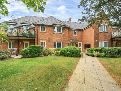 2 bedroom flat for sale in Church Road, Stanmore, HA7 — £650,000 • 2 bed • 2 bath • 1284 ft²
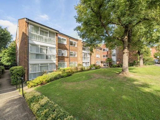 2 bedroom flat for sale in Aran Drive, Stanmore, HA7 — £425,000 • 2 bed • 1 bath • 876 ft²
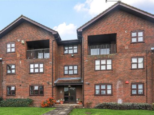 2 bedroom apartment for sale in Marsh Lane, Stanmore, HA7 — £400,000 • 2 bed • 2 bath • 878 ft²
 2 bedroom flat for sale in Church Road, Stanmore, HA7 — £640,000 • 2 bed • 2 bath • 1277 ft²
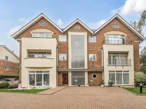 2 bedroom flat for sale in The Apartments, Stanmore, HA7 — £875,000 • 2 bed • 2 bath • 1397 ft²
Meta
- {
"@context": "https://schema.org",
"@type": "Residence",
"name": "2 bedroom flat for sale in Albemarle Park, Stanmore, HA7",
"description": "",
"url": "https://propertypiper.co.uk/property/6d3817a1-0e9d-48f9-ad26-bd6dc7d8a019",
"image": "https://image-a.propertypiper.co.uk/6fc7ecc2-8a2e-43e4-b06a-ac269d0edd1f-1024.jpeg",
"address": {
"@type": "PostalAddress",
"streetAddress": "10 ALBEMARLE PARK STANMORE",
"postalCode": "HA7 4HL",
"addressLocality": "Harrow",
"addressRegion": "Harrow East",
"addressCountry": "England"
},
"geo": {
"@type": "GeoCoordinates",
"latitude": 51.61594006581057,
"longitude": -0.30800511818765197
},
"numberOfRooms": 2,
"numberOfBathroomsTotal": 1,
"floorSize": {
"@type": "QuantitativeValue",
"value": 900,
"unitCode": "FTK"
},
"offers": {
"@type": "Offer",
"price": 450000,
"priceCurrency": "GBP",
"availability": "https://schema.org/InStock"
},
"additionalProperty": [
{
"@type": "PropertyValue",
"name": "Feature",
"value": "apartment complex"
},
{
"@type": "PropertyValue",
"name": "Feature",
"value": "mid-century"
},
{
"@type": "PropertyValue",
"name": "Feature",
"value": "brick facade"
},
{
"@type": "PropertyValue",
"name": "Feature",
"value": "balconies"
},
{
"@type": "PropertyValue",
"name": "Feature",
"value": "three-story"
},
{
"@type": "PropertyValue",
"name": "Feature",
"value": "landscaped garden"
},
{
"@type": "PropertyValue",
"name": "Feature",
"value": "communal areas"
},
{
"@type": "PropertyValue",
"name": "Feature",
"value": "living room"
},
{
"@type": "PropertyValue",
"name": "Feature",
"value": "mid-20th century"
},
{
"@type": "PropertyValue",
"name": "Feature",
"value": "natural light"
},
{
"@type": "PropertyValue",
"name": "Feature",
"value": "dated decor"
},
{
"@type": "PropertyValue",
"name": "Feature",
"value": "chandelier lighting"
},
{
"@type": "PropertyValue",
"name": "Feature",
"value": "balcony access"
},
{
"@type": "PropertyValue",
"name": "Feature",
"value": "maintenance needed"
},
{
"@type": "PropertyValue",
"name": "Feature",
"value": "potential modernisation"
},
{
"@type": "PropertyValue",
"name": "Feature",
"value": "unappealing carpet"
},
{
"@type": "PropertyValue",
"name": "Feature",
"value": "spacious layout"
}
]
}
High Res Floorplan Images
Compatible Floorplan Images
FloorplanImages Thumbnail