SO15 2XE - 1 bedroom retirement property for sale in Flats 1 66, 1 BAN…
View on Property Piper
1 bedroom retirement property for sale in Flats 1 - 66,
1 BANISTER ROAD,
Southampton,
SO15
Property Details
- Price: £275000
- Bedrooms: 1
- Bathrooms: 1
- Property Type: undefined
- Property SubType: undefined
Brochure Descriptions
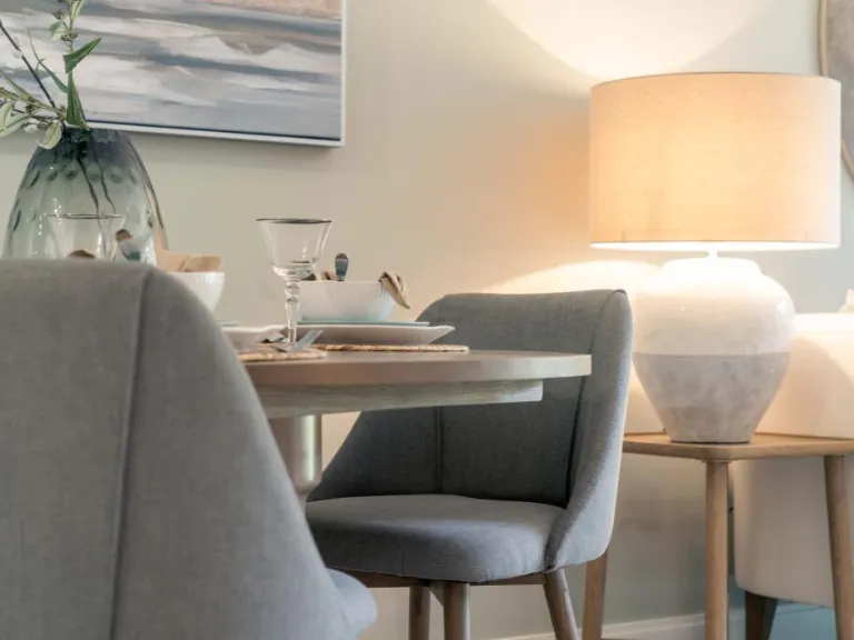
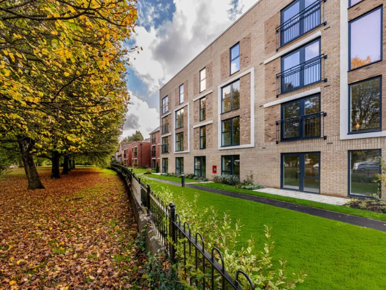
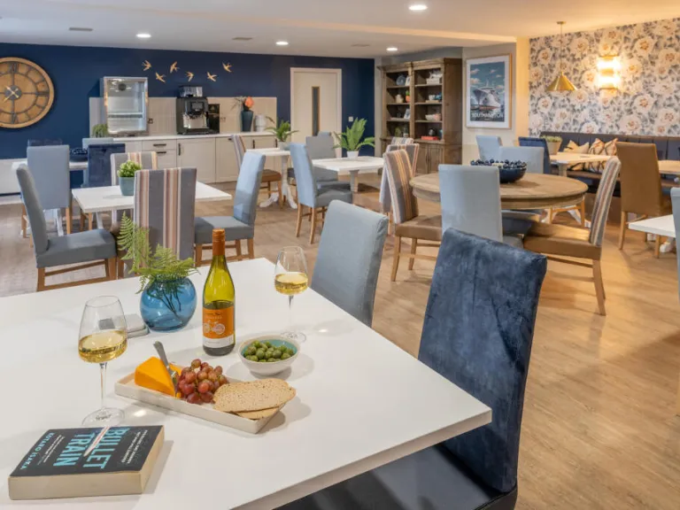
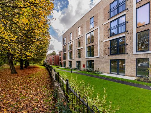
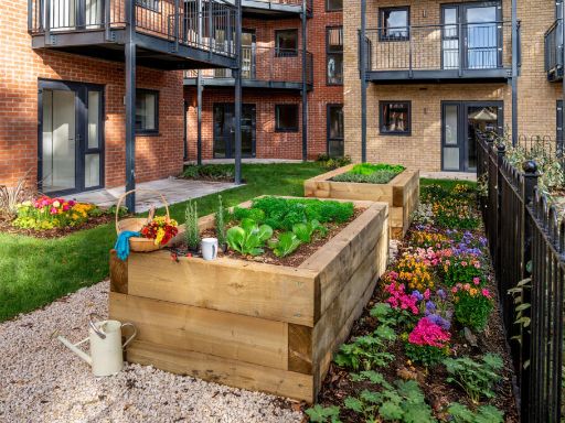
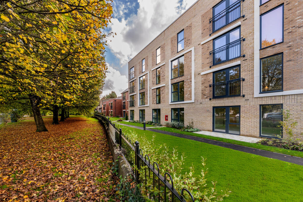
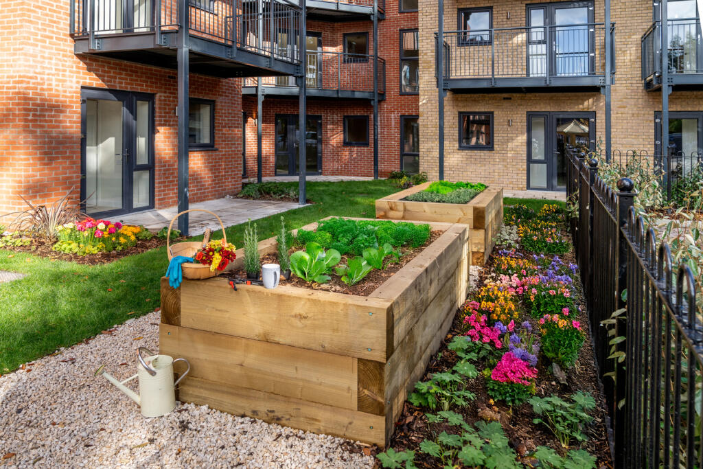
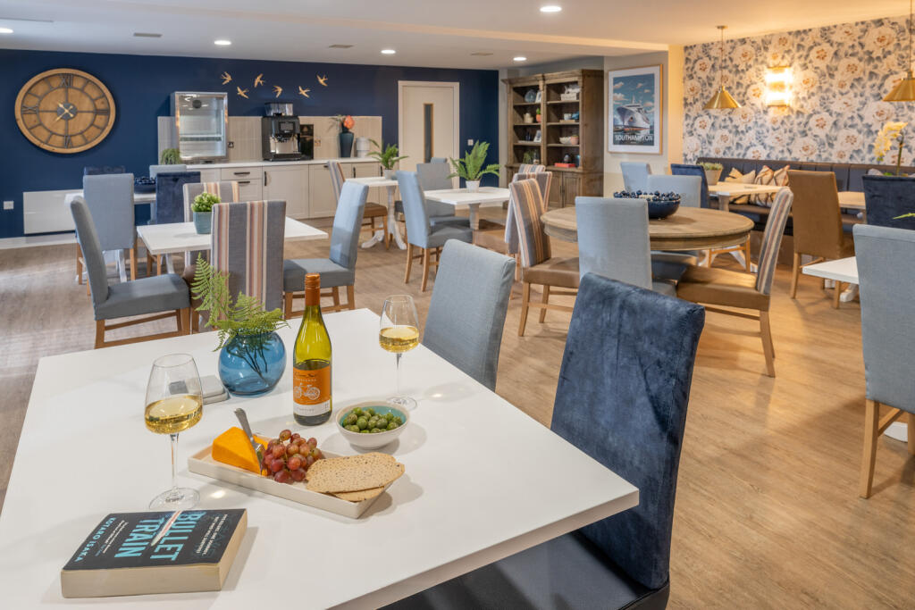
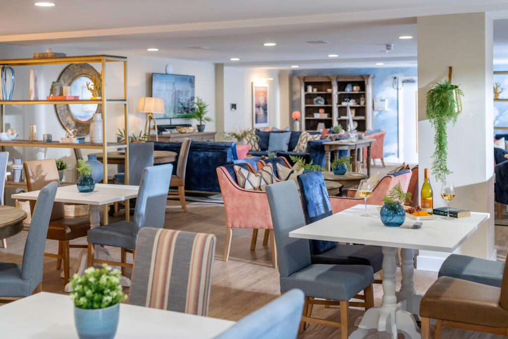
- Purpose-built retirement/residential apartment development in Southampton. The scheme comprises low-rise (predominantly 3–4 storey) brick-built apartment blocks with private balconies and a central communal courtyard/landscaped amenity area. The development presents a modern, well-proportioned urban courtyard layout with secure perimeter fencing and pedestrianised paving. Overall impression: medium-density apartment scheme; communal grounds are small-to-medium in size, suitable for low-maintenance outdoor amenity rather than large private gardens. Likely suitable for one- and two-bedroom apartments with accessible circulation and on-site communal facilities. No internal accommodation or exact floor areas visible from images.
- No specific residential property or address is visible on this page. The image appears to be the back or information page of a McCarthy Stone brochure containing contact details (phone number 0800 201 4106), logos and legal/disclaimer text rather than photographs or specification of a particular flat or house. There are no images or text from which to infer accommodation layout, number of rooms, garden or overall property size. Unable to determine views or square footage from the provided image.
- Document appears to be a brochure cover for a development in Southampton titled 'Maytree Place'. No photographs or floorplans of the residential unit are visible on this page, so internal layout, number of rooms and exact plot particulars cannot be determined. The page gives the impression of a larger development brochure rather than a single house listing. No garden or external views are shown and no furniture or removable items are present. Property size and total square footage cannot be inferred from this image.
Image Descriptions
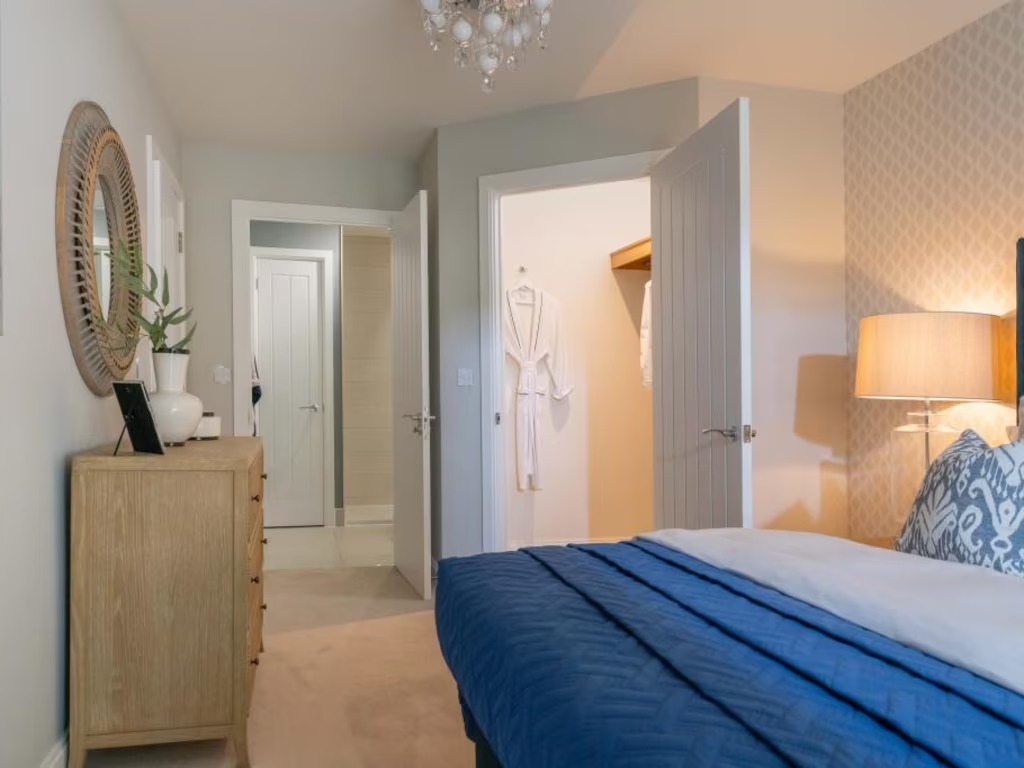
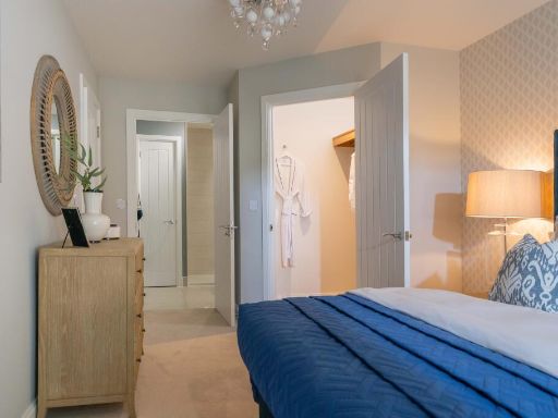
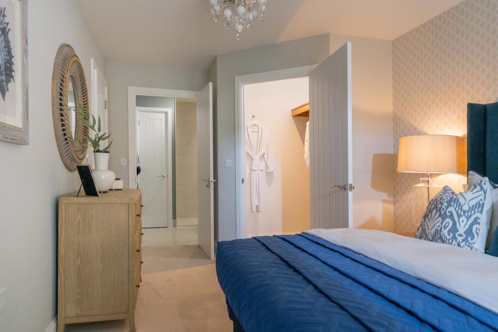
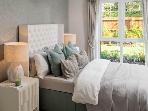
- bedroom modern
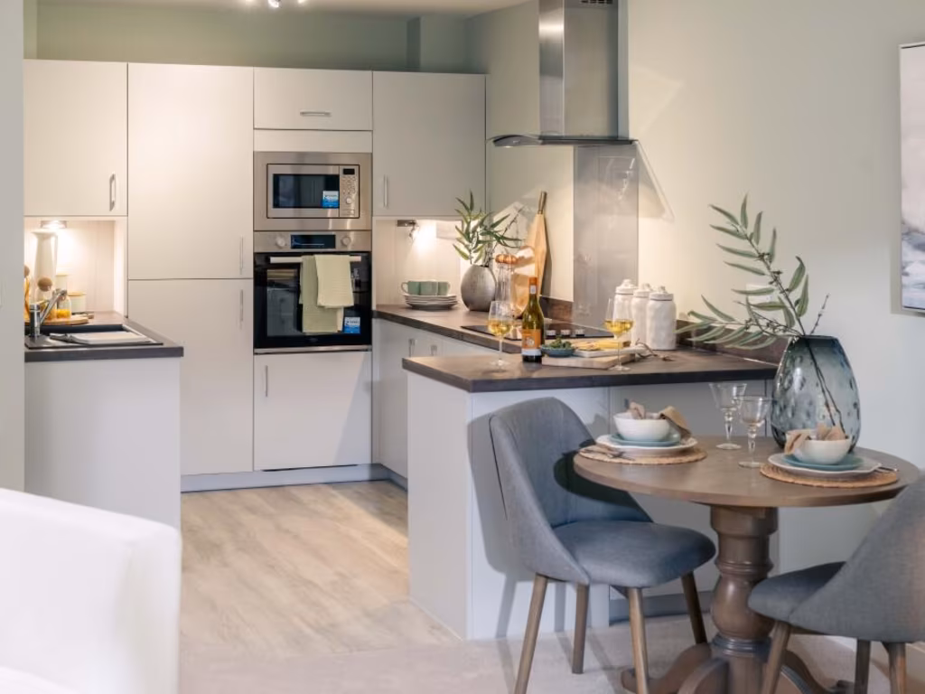
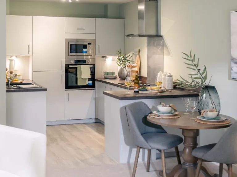
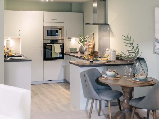
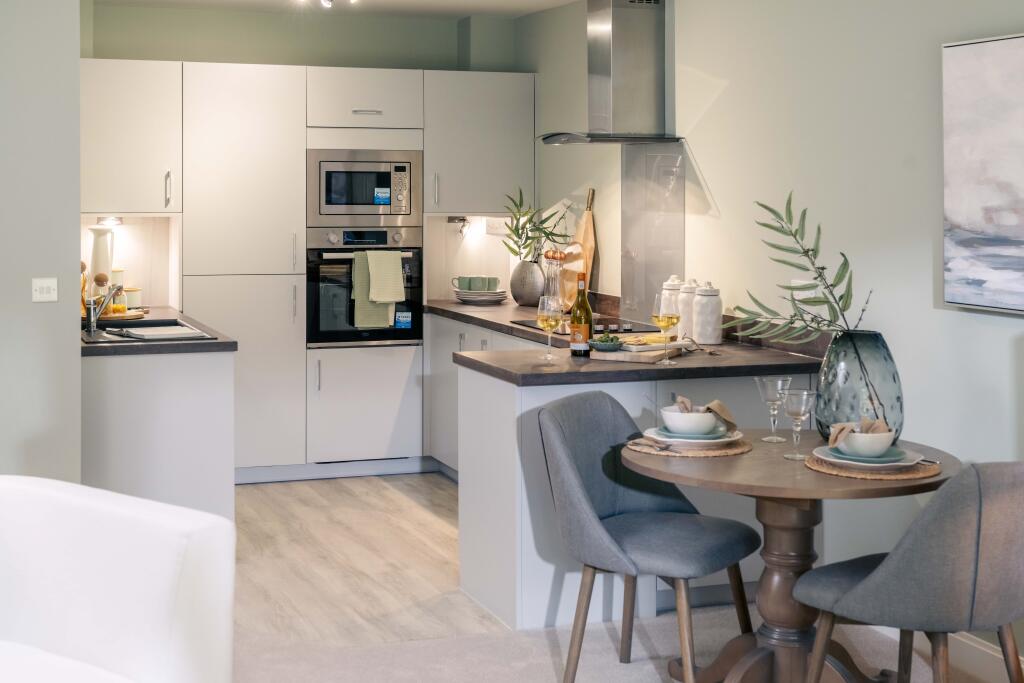
- kitchen modern
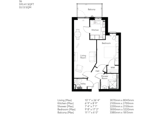
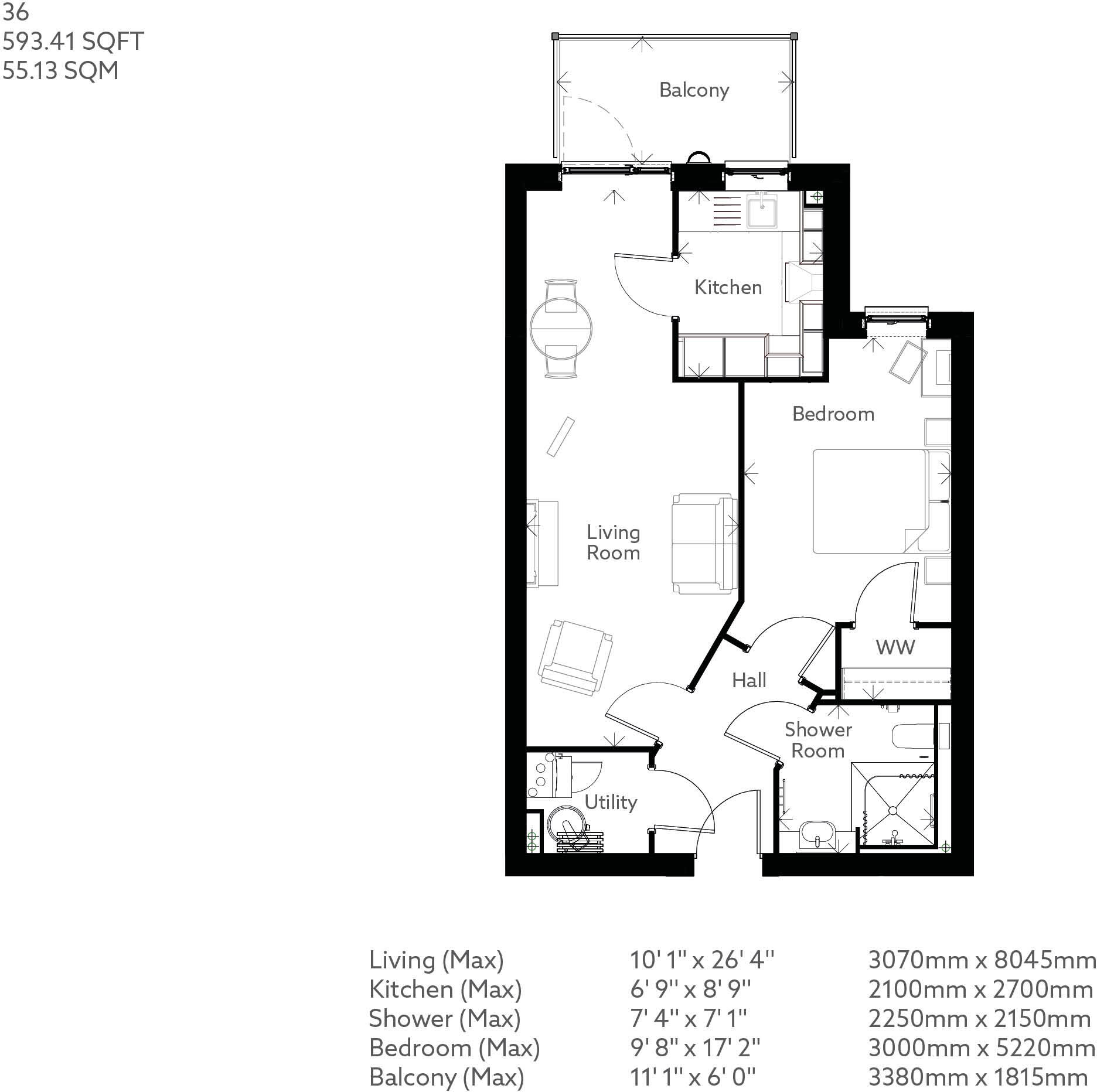
Floorplan Description
- One-bedroom apartment with living room, kitchen, shower room and utility.
Rooms
- Living Room:
- Kitchen:
- Shower Room:
- Bedroom:
- Balcony:
- Utility:
- Hall:
- WW:
Textual Property Features
Detected Visual Features
- modern bedroom
- carpeted floor
- standard ceiling height
- contemporary design
- modern kitchen
- integrated appliances
- breakfast bar
- stainless steel
- high gloss cabinets
- contemporary
- open plan
EPC Details
- High performance glazing
- Average thermal transmittance 0.20 W/m-¦K
- Room heaters, electric
- Low energy lighting in all fixed outlets
- (other premises below)
Nearby Schools
- St John's Primary and Nursery School
- Freemantle Church of England Community Academy
- St Mark's Church of England School
- King Edward VI School
- Highfield Church of England Primary School
- Hollybrook Junior School
- Bassett Green Primary School
- Cantell School
- Maytree Nursery and Infants' School
- Bevois Town Primary School
- St Denys Primary School
- Upper Shirley High School
- Portswood Primary School
- Hope Community School Southampton
- Springhill Catholic Primary School
- Mount Pleasant Junior School
- Shirley Junior School
- Swaythling Primary School
- St Mary's Church of England Voluntary Controlled Primary School
- St Anne's Catholic School
- Banister Primary School
- The Gregg Preparatory School
- Shirley Infant School
- Hollybrook Infant School
Nearest General Shops
- Id: 163861633
- Tags:
- Addr:
- City: Southampton
- Country: GB
- Housenumber: 115
- Postcode: SO14 6QT
- Street: Lodge Road
- Brand: Kwik Fit
- Brand:wikidata: Q958053
- Brand:wikipedia: en:Kwik Fit
- Building: yes
- Name: Kwik Fit
- Shop: car_repair
- TagsNormalized:
- kwik fit
- car repair
- repair
- shop
- Lat: 50.9187826
- Lon: -1.4011684
- FullGeoHash: gcp18j7xqmj1
- PartitionGeoHash: gcp1
- Images:
- FoodStandards: null
- Distance: 270
,- Id: 164102776
- Tags:
- Addr:
- City: Southampton
- Country: GB
- Housenumber: 39
- Postcode: SO17 1XN
- Street: The Avenue
- Building: yes
- Contact:
- Website: http://www.stag-gates.co.uk/
- Name: Stag gates garage & Marine
- Shop: car_repair
- TagsNormalized:
- garage
- car repair
- repair
- shop
- Lat: 50.9186727
- Lon: -1.4030361
- FullGeoHash: gcp18j6qfbs3
- PartitionGeoHash: gcp1
- Images:
- FoodStandards: null
- Distance: 143.3
,- Id: 10276508381
- Tags:
- Check_date: 2022-12-20
- Level: 0
- Name: Twin Scissors
- Shop: hairdresser
- TagsNormalized:
- Lat: 50.9191051
- Lon: -1.4044222
- FullGeoHash: gcp18j93694v
- PartitionGeoHash: gcp1
- Images:
- FoodStandards: null
- Distance: 117
}
Nearest Grocery shops
- Id: 161239881
- Tags:
- Addr:
- City: Southampton
- Country: GB
- Housenumber: 48;48B
- Postcode: SO14 6RJ
- Street: Lodge Road
- Brand: Premier
- Brand:wikidata: Q7240340
- Brand:wikipedia: en:Premier Stores
- Building: yes
- Name: Lodge Road Convenience Store
- Operator: Premier
- Phone: +44 2380 225434
- Shop: convenience
- TagsNormalized:
- Lat: 50.9196694
- Lon: -1.3981511
- FullGeoHash: gcp18jtusdqg
- PartitionGeoHash: gcp1
- Images:
- FoodStandards: null
- Distance: 502
,- Id: 243155326
- Tags:
- Addr:
- City: Southampton
- Country: GB
- Housenumber: 91;91 Room 1;2;3
- Postcode: SO14 6RE
- Street: Lodge Road
- Brand: Best-one
- Brand:wikidata: Q4896532
- Brand:wikipedia: en:Best-one
- Building: yes
- Name: Best-one
- Shop: convenience
- TagsNormalized:
- Lat: 50.9190282
- Lon: -1.3995428
- FullGeoHash: gcp18jsbu6c6
- PartitionGeoHash: gcp1
- Images:
- FoodStandards: null
- Distance: 387.1
,- Id: 4514104989
- Tags:
- Name: The Co-operative Archers Road
- Name:de: The Co-operative Archers Road
- Name:en: The Co-operative Archers Road
- Shop: convenience
- TagsNormalized:
- Lat: 50.9161897
- Lon: -1.4084219
- FullGeoHash: gcncxvn2m3sw
- PartitionGeoHash: gcnc
- Images:
- FoodStandards: null
- Distance: 327.1
}
Nearest Supermarkets
- Id: 33831064
- Tags:
- Addr:
- City: Southampton
- Country: GB
- Housenumber: 121-131
- Postcode: SO17 2FX
- Street: Portswood Road
- Brand: Waitrose
- Brand:wikidata: Q771734
- Brand:wikipedia: en:Waitrose
- Building: yes
- Name: Waitrose
- Note: This store has no cafe or toilets.
- Official_name: Waitrose & Partners
- Operator: Waitrose & Partners
- Shop: supermarket
- TagsNormalized:
- Lat: 50.924337
- Lon: -1.3947431
- FullGeoHash: gcp18q2ru0kn
- PartitionGeoHash: gcp1
- Images:
- FoodStandards: null
- Distance: 992.7
,- Id: 37839166
- Tags:
- Brand: ALDI
- Brand:wikidata: Q41171672
- Brand:wikipedia: en:Aldi
- Building: yes
- Contact:
- Website: https://stores.aldi.co.uk/southampton/88-96-bevois-valley-road
- Name: ALDI
- Shop: supermarket
- TagsNormalized:
- Lat: 50.9174521
- Lon: -1.3949752
- FullGeoHash: gcp18m0pwtp0
- PartitionGeoHash: gcp1
- Images:
- FoodStandards: null
- Distance: 696.6
,- Id: 865191541
- Tags:
- Addr:
- City: Southampton
- Country: GB
- Postcode: SO15 2XD
- Street: Banister Road
- Brand: Lidl
- Brand:wikidata: Q151954
- Brand:wikipedia: en:Lidl
- Building: yes
- Fhrs:
- Name: Lidl
- Shop: supermarket
- TagsNormalized:
- Lat: 50.9185881
- Lon: -1.4055549
- FullGeoHash: gcp18j2w20y3
- PartitionGeoHash: gcp1
- Images:
- FoodStandards:
- Id: 1379188
- FHRSID: 1379188
- LocalAuthorityBusinessID: 21/00166/FOOD
- BusinessName: Lidl
- BusinessType: Retailers - supermarkets/hypermarkets
- BusinessTypeID: 7840
- AddressLine1: Banister Road
- AddressLine2: Southampton
- AddressLine3: null
- AddressLine4: null
- PostCode: SO15 2XD
- RatingValue: 5
- RatingKey: fhrs_5_en-GB
- RatingDate: 2023-01-04
- LocalAuthorityCode: 877
- LocalAuthorityName: Southampton
- LocalAuthorityWebSite: http://www.southampton.gov.uk
- LocalAuthorityEmailAddress: hygiene.rating@southampton.gov.uk
- Scores:
- Hygiene: 0
- Structural: 0
- ConfidenceInManagement: 0
- NewRatingPending: false
- Geocode:
- Longitude: -1.40478503704071
- Latitude: 50.91851806640630
- Distance: 73.8
}
Nearest Religious buildings
- Id: 161562762
- Tags:
- Amenity: place_of_worship
- Building: yes
- Name: Harry's Corridors
- Religion: Dotaist
- TagsNormalized:
- Lat: 50.9208188
- Lon: -1.4043774
- FullGeoHash: gcp18jc778s7
- PartitionGeoHash: gcp1
- Images:
- FoodStandards: null
- Distance: 305.3
,- Id: 182188150
- Tags:
- Addr:
- City: Southampton
- Country: GB
- Postcode: SO14 6GP
- Street: Mordaunt Road
- Amenity: place_of_worship
- Building: yes
- Religion: jewish
- TagsNormalized:
- place of worship
- jewish
- synagogue
- Lat: 50.9170708
- Lon: -1.4008209
- FullGeoHash: gcp18j5vqtbn
- PartitionGeoHash: gcp1
- Images:
- FoodStandards: null
- Distance: 305
,- Id: 242931994
- Tags:
- Addr:
- City: Southampton
- Country: GB
- Postcode: SO14 6RF
- Street: Lodge Road
- Amenity: place_of_worship
- Building: yes
- Denomination: anglican
- Name: St Barnabas Church
- Religion: christian
- Wikidata: Q105105061
- TagsNormalized:
- place of worship
- anglican
- church
- christian
- Lat: 50.9191948
- Lon: -1.4018679
- FullGeoHash: gcp18je1y1gs
- PartitionGeoHash: gcp1
- Images:
- FoodStandards: null
- Distance: 243.1
}
Nearest Medical buildings
- Id: 937899395
- Tags:
- Amenity: pharmacy
- Building: yes
- Dispensing: yes
- Healthcare: pharmacy
- Name: Basset's Pharmacy
- TagsNormalized:
- Lat: 50.9139808
- Lon: -1.4061235
- FullGeoHash: gcp18h856vym
- PartitionGeoHash: gcp1
- Images:
- FoodStandards: null
- Distance: 465.4
,- Id: 224889488
- Tags:
- Amenity: dentist
- Building: yes
- Healthcare: dentist
- Name: Westrow Dental Surgery
- TagsNormalized:
- dentist
- health
- healthcare
- dental
- surgery
- Lat: 50.9163146
- Lon: -1.4104637
- FullGeoHash: gcncxvhcjbfp
- PartitionGeoHash: gcnc
- Images:
- FoodStandards: null
- Distance: 439.6
,- Id: 224302595
- Tags:
- Addr:
- City: Southampton
- Housenumber: 14
- Postcode: SO15 2HQ
- Street: Carlton Road
- Amenity: doctors
- Building: yes
- Healthcare: doctor
- Name: Walnut Tree Surgery
- Opening_hours: Mo-Fr 09:00-11:30,15:30-17:30
- Phone: +44 23 80333326
- Website: https://www.walnuttreesurgery.nhs.uk/
- TagsNormalized:
- doctor
- doctors
- health
- healthcare
- surgery
- Lat: 50.9149038
- Lon: -1.4066173
- FullGeoHash: gcncxuz8z3yp
- PartitionGeoHash: gcnc
- Images:
- FoodStandards: null
- Distance: 375.1
,- Id: 162539310
- Tags:
- Addr:
- City: Southampton
- Housenumber: 47
- Postcode: SO17 1XP
- Street: The Avenue
- Amenity: dentist
- Building: yes
- Healthcare: dentist
- Name: The Avenue Dental Practice
- Website: https://www.healthwatchsouthampton.co.uk/services/avenue-dental-practice-limited-southampton-so17-1xp/
- TagsNormalized:
- dentist
- health
- healthcare
- dental
- Lat: 50.9198475
- Lon: -1.4038721
- FullGeoHash: gcp18j9tx7t1
- PartitionGeoHash: gcp1
- Images:
- FoodStandards: null
- Distance: 207.3
}
Nearest Airports
- Id: 100647893
- Tags:
- Aerodrome: international
- Aerodrome:type: public
- Aeroway: aerodrome
- Contact:
- Vhf:
- Approach: 120.225 MHz
- Tower: 118.2 MHz
- Ele: 44ft
- Iata: SOU
- Icao: EGHI
- Is_in: Hampshire, England,UK
- Name: Southampton Airport
- Operator: Southampton International Airport Limited
- Source: Bing;Gagravarr_Airports
- Wikidata: Q8988
- Wikipedia: en:Southampton Airport
- TagsNormalized:
- airport
- international airport
- Lat: 50.9513872
- Lon: -1.3516684
- FullGeoHash: gcp1c5rtrffz
- PartitionGeoHash: gcp1
- Images:
- FoodStandards: null
- Distance: 5253.8
}
Nearest Leisure Facilities
- Id: 148349927
- Tags:
- Leisure: playground
- Source: Bing
- TagsNormalized:
- Lat: 50.9195752
- Lon: -1.4093121
- FullGeoHash: gcncxvtu08u9
- PartitionGeoHash: gcnc
- Images:
- FoodStandards: null
- Distance: 353.1
,- Id: 286753461
- Tags:
- Landcover: grass
- Leisure: park
- TagsNormalized:
- Lat: 50.9153868
- Lon: -1.4044678
- FullGeoHash: gcp18hc79s0b
- PartitionGeoHash: gcp1
- Images:
- FoodStandards: null
- Distance: 301.8
,- Id: 22800095
- Tags:
- Leisure: park
- Name: Asylum Green
- Natural: tree
- Source: Bing
- TagsNormalized:
- Lat: 50.9163516
- Lon: -1.4025403
- FullGeoHash: gcp18j49nry5
- PartitionGeoHash: gcp1
- Images:
- FoodStandards: null
- Distance: 252.6
,- Id: 224917542
- Tags:
- TagsNormalized:
- Lat: 50.9177299
- Lon: -1.4084126
- FullGeoHash: gcncxvq3m8g3
- PartitionGeoHash: gcnc
- Images:
- FoodStandards: null
- Distance: 252.2
,- Id: 743127120
- Tags:
- TagsNormalized:
- swimming
- swimming pool
- pool
- leisure
- Lat: 50.9182959
- Lon: -1.408332
- FullGeoHash: gcncxvqkx6rd
- PartitionGeoHash: gcnc
- Images:
- FoodStandards: null
- Distance: 244.5
}
Nearest Tourist attractions
- Id: 224411816
- Tags:
- Addr:
- City: Southampton
- Housename: Fenland Guest House
- Housenumber: 79
- Postcode: SO15 5AD
- Street: Hill Lane
- Building: yes
- Name: Fenland Guest House
- Tourism: guest_house
- Website: http://www.fenlandguesthouse.co.uk
- TagsNormalized:
- Lat: 50.9146082
- Lon: -1.4150379
- FullGeoHash: gcncxu9x54zk
- PartitionGeoHash: gcnc
- Images:
- FoodStandards: null
- Distance: 811.8
,- Id: 235881047
- Tags:
- Addr:
- City: Southampton
- Housenumber: 137
- Postcode: SO15 5AF
- Street: Hill Lane
- Building: yes
- Name: Madison House
- Stars: 3
- Tourism: guest_house
- TagsNormalized:
- Lat: 50.9178508
- Lon: -1.4149209
- FullGeoHash: gcncxv39vzqe
- PartitionGeoHash: gcnc
- Images:
- FoodStandards: null
- Distance: 705.8
,- Id: 4413122775
- Tags:
- Information: sign
- Tourism: yes
- TagsNormalized:
- Lat: 50.9217248
- Lon: -1.4056803
- FullGeoHash: gcp18n02t38b
- PartitionGeoHash: gcp1
- Images:
- FoodStandards: null
- Distance: 408.2
}
Nearest Bus stations and stops
- Id: 1974284507
- Tags:
- Bus: yes
- Highway: bus_stop
- Name: Carlton Road
- Naptan:
- Public_transport: platform
- TagsNormalized:
- Lat: 50.9163154
- Lon: -1.4063637
- FullGeoHash: gcncxvpcj35h
- PartitionGeoHash: gcnc
- Images:
- FoodStandards: null
- Distance: 223.7
,- Id: 1974284510
- Tags:
- Bus: yes
- Highway: bus_stop
- Name: Banister Road
- Public_transport: platform
- TagsNormalized:
- Lat: 50.9173348
- Lon: -1.4067864
- FullGeoHash: gcncxvpwgx0j
- PartitionGeoHash: gcnc
- Images:
- FoodStandards: null
- Distance: 159
,- Id: 1974284496
- Tags:
- Bus: yes
- Highway: bus_stop
- Name: Stag Gates
- Naptan:
- AtcoCode: 1980SN120403
- Bearing: E
- CommonName: Stag Gates
- NaptanCode: sohdapw
- Street: Lodge Road
- Verified: no
- Public_transport: platform
- Shelter: yes
- Tactile_paving: no
- TagsNormalized:
- Lat: 50.9188906
- Lon: -1.4032471
- FullGeoHash: gcp18jd0jcpj
- PartitionGeoHash: gcp1
- Images:
- FoodStandards: null
- Distance: 143.9
,- Id: 1045972060
- Tags:
- Bench: yes
- Bin: no
- Bus: yes
- Highway: bus_stop
- Name: Stag Gates
- Naptan:
- AtcoCode: 1980SN120404
- Bearing: SE
- CommonName: Stag Gates
- NaptanCode: sohdgjd
- Street: The Avenue
- Verified: no
- Public_transport: platform
- Shelter: yes
- Tactile_paving: no
- TagsNormalized:
- Lat: 50.9180716
- Lon: -1.4031189
- FullGeoHash: gcp18j672bw8
- PartitionGeoHash: gcp1
- Images:
- FoodStandards: null
- Distance: 122.1
,- Id: 1045972095
- Tags:
- Bench: yes
- Bus: yes
- Highway: bus_stop
- Name: Stag Gates
- Naptan:
- AtcoCode: 1980SN120401
- Bearing: N
- CommonName: Stag Gates
- NaptanCode: sohdajg
- Street: The Avenue
- Verified: no
- Public_transport: platform
- Shelter: yes
- TagsNormalized:
- Lat: 50.9189175
- Lon: -1.4040795
- FullGeoHash: gcp18j984w4q
- PartitionGeoHash: gcp1
- Images:
- FoodStandards: null
- Distance: 107.1
}
Nearest Hotels
- Id: 235877972
- Tags:
- Addr:
- City: Southampton
- Street: Northlands Road
- Amenity: pub
- Building: yes
- Name: The Blue Keys Hotel
- TagsNormalized:
- Lat: 50.91628
- Lon: -1.4134385
- FullGeoHash: gcncxv4bb6xb
- PartitionGeoHash: gcnc
- Images:
- FoodStandards: null
- Distance: 634.2
,- Id: 162539295
- Tags:
- Addr:
- City: Southampton
- Country: GB
- Housename: Elizabeth House Hotel
- Housenumber: 42-44
- Postcode: SO17 1XP
- Street: The Avenue
- Building: hotel
- Contact:
- Name: Elizabeth House Hotel
- Tourism: hotel
- Website: http://elizabethhousehotel.com/
- TagsNormalized:
- Lat: 50.9193929
- Lon: -1.4035418
- FullGeoHash: gcp18j9fzng6
- PartitionGeoHash: gcp1
- Images:
- FoodStandards: null
- Distance: 171.8
,- Id: 162539296
- Tags:
- Addr:
- City: Southampton
- Country: GB
- Housenumber: 144
- Postcode: SO14 6QR
- Street: Lodge Road
- Brand: Travelodge
- Brand:wikidata: Q9361374
- Brand:wikipedia: en:Travelodge UK
- Building: yes
- Fhrs:
- Authority: Southampton
- Id: 220218
- Local_authority_id: 11150/2000/2/000
- Internet_access: wlan
- Internet_access:fee: customers
- Internet_access:ssid: Travelodge WiFi
- Name: Travelodge Southampton
- Operator: Travelodge
- Tourism: hotel
- TagsNormalized:
- Lat: 50.91905
- Lon: -1.4033182
- FullGeoHash: gcp18jd0uqfh
- PartitionGeoHash: gcp1
- Images:
- FoodStandards: null
- Distance: 151.9
}
Tags
- modern bedroom
- carpeted floor
- standard ceiling height
- contemporary design
- modern kitchen
- integrated appliances
- breakfast bar
- stainless steel
- high gloss cabinets
- contemporary
- open plan
Local Market Stats
- Average Price/sqft: £288
- Avg Income: £52400
- Rental Yield: 5.7%
- Social Housing: 14%
- Planning Success Rate: 85%
AirBnB Data
- 1km average: £105/night
- Listings in 1km: 37
Similar Properties
 1 bedroom retirement property for sale in Flats 1 - 66,
1 BANISTER ROAD,
Southampton,
SO15 — £250,000 • 1 bed • 1 bath • 593 ft²
1 bedroom retirement property for sale in Flats 1 - 66,
1 BANISTER ROAD,
Southampton,
SO15 — £250,000 • 1 bed • 1 bath • 593 ft²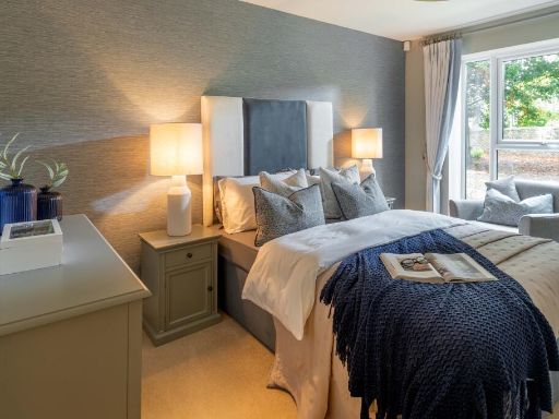 2 bedroom retirement property for sale in Flats 1 - 66,
1 BANISTER ROAD,
Southampton,
SO15 — £308,000 • 2 bed • 1 bath • 789 ft²
2 bedroom retirement property for sale in Flats 1 - 66,
1 BANISTER ROAD,
Southampton,
SO15 — £308,000 • 2 bed • 1 bath • 789 ft²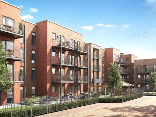 1 bedroom retirement property for sale in The Avenue, Southampton, Hampshire, SO17 — £350,000 • 1 bed • 1 bath • 650 ft²
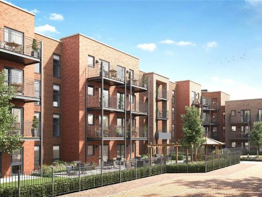 1 bedroom retirement property for sale in The Avenue, Southampton, Hampshire, SO17 — £263,000 • 1 bed • 1 bath • 544 ft²
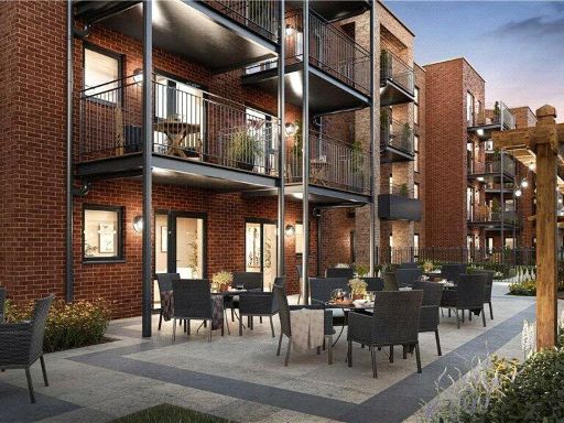 1 bedroom apartment for sale in Maytree Place, The Avenue, Southampton, Hampshire, SO17 — £263,000 • 1 bed • 1 bath • 593 ft²
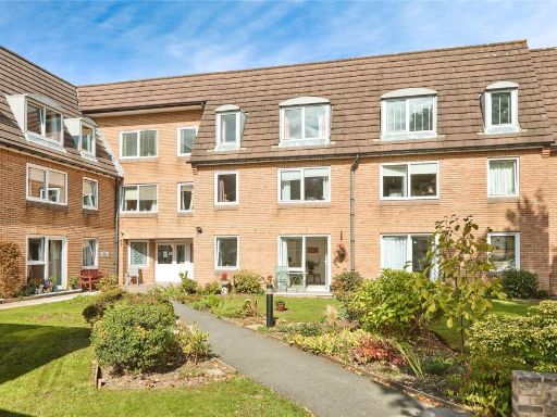 1 bedroom apartment for sale in Homepoint House, Bitterne, SO18 — £50,000 • 1 bed • 1 bath • 446 ft²
Meta
- {
"@context": "https://schema.org",
"@type": "Residence",
"name": "1 bedroom retirement property for sale in Flats 1 66, 1 BAN…",
"description": "",
"url": "https://propertypiper.co.uk/property/547a7e3d-daa9-42ee-bc63-f5e2d64d17fc",
"image": "https://image-a.propertypiper.co.uk/1d21c529-79b2-413c-b519-fbafde72f322-1024.jpeg",
"address": {
"@type": "PostalAddress",
"streetAddress": "Flats 1 - 66, \r\n1 BANISTER ROAD,\r\nSouthampton,\r\nSO15",
"postalCode": "SO15 2XE",
"addressLocality": "Southampton",
"addressRegion": "Southampton, Itchen",
"addressCountry": "England"
},
"geo": {
"@type": "GeoCoordinates",
"latitude": 50.91809,
"longitude": -1.40486
},
"numberOfRooms": 1,
"numberOfBathroomsTotal": 1,
"floorSize": {
"@type": "QuantitativeValue",
"value": 593,
"unitCode": "FTK"
},
"offers": {
"@type": "Offer",
"price": 275000,
"priceCurrency": "GBP",
"availability": "https://schema.org/InStock"
},
"additionalProperty": [
{
"@type": "PropertyValue",
"name": "Feature",
"value": "modern bedroom"
},
{
"@type": "PropertyValue",
"name": "Feature",
"value": "carpeted floor"
},
{
"@type": "PropertyValue",
"name": "Feature",
"value": "standard ceiling height"
},
{
"@type": "PropertyValue",
"name": "Feature",
"value": "contemporary design"
},
{
"@type": "PropertyValue",
"name": "Feature",
"value": "modern kitchen"
},
{
"@type": "PropertyValue",
"name": "Feature",
"value": "integrated appliances"
},
{
"@type": "PropertyValue",
"name": "Feature",
"value": "breakfast bar"
},
{
"@type": "PropertyValue",
"name": "Feature",
"value": "stainless steel"
},
{
"@type": "PropertyValue",
"name": "Feature",
"value": "high gloss cabinets"
},
{
"@type": "PropertyValue",
"name": "Feature",
"value": "contemporary"
},
{
"@type": "PropertyValue",
"name": "Feature",
"value": "open plan"
}
]
}
High Res Floorplan Images
Compatible Floorplan Images
FloorplanImages Thumbnail