NR31 7RQ - Light industrial facility for sale in Excalibur Road, Gorle…
View on Property Piper
Light industrial facility for sale in Excalibur Road, Gorleston, NR31
Property Details
- Price: £350000
- Bedrooms: 1
- Bathrooms: 1
- Property Type: undefined
- Property SubType: undefined
Brochure Descriptions
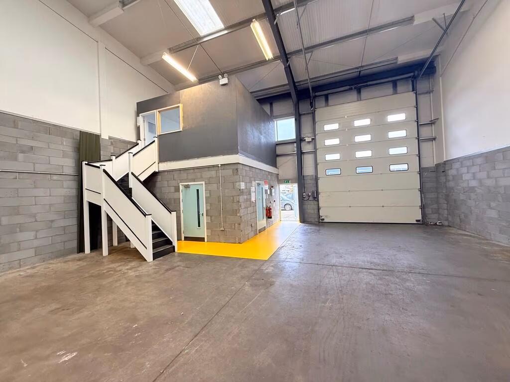
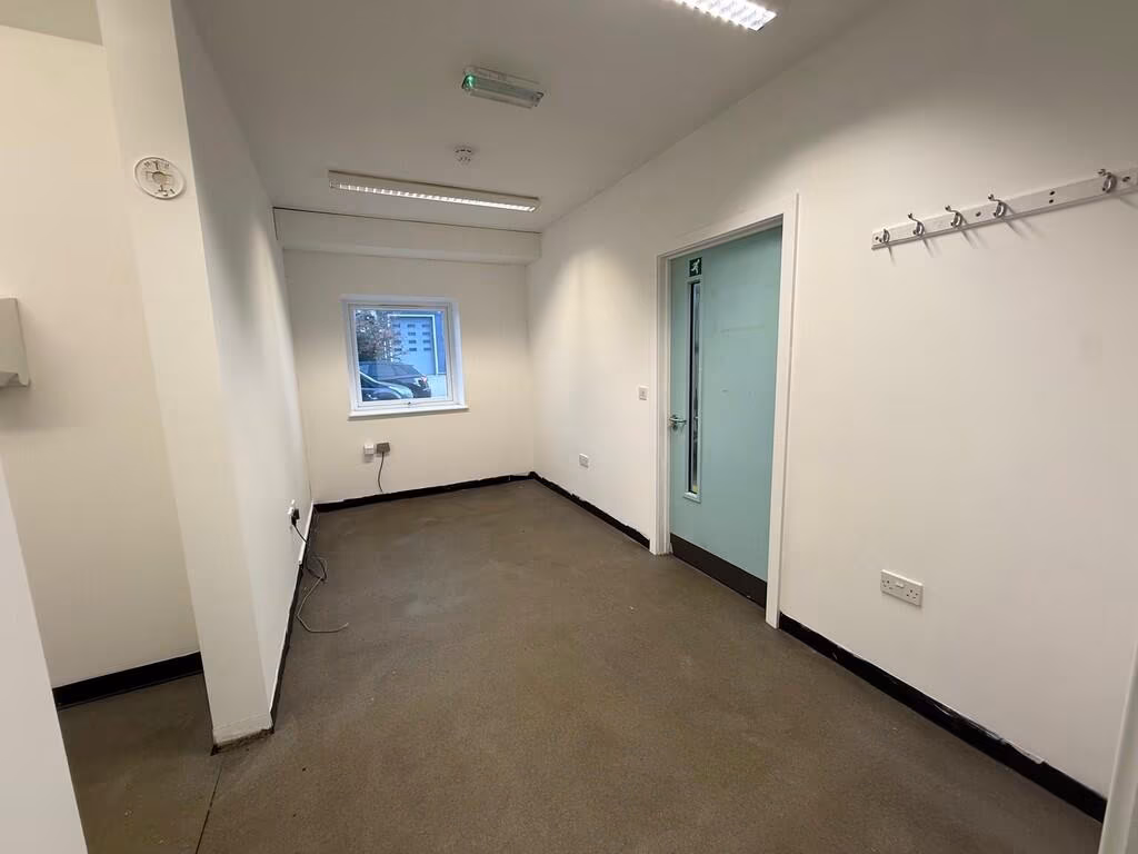
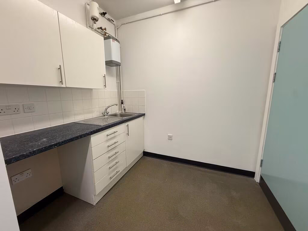
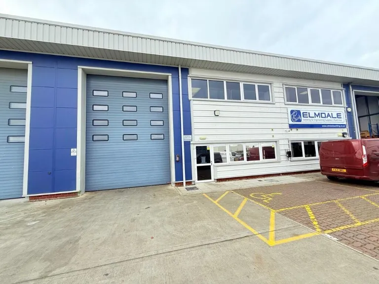
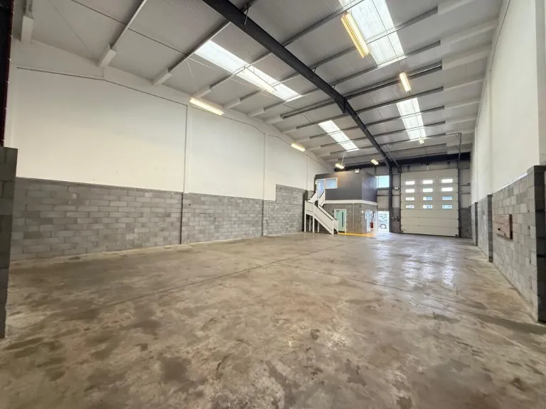
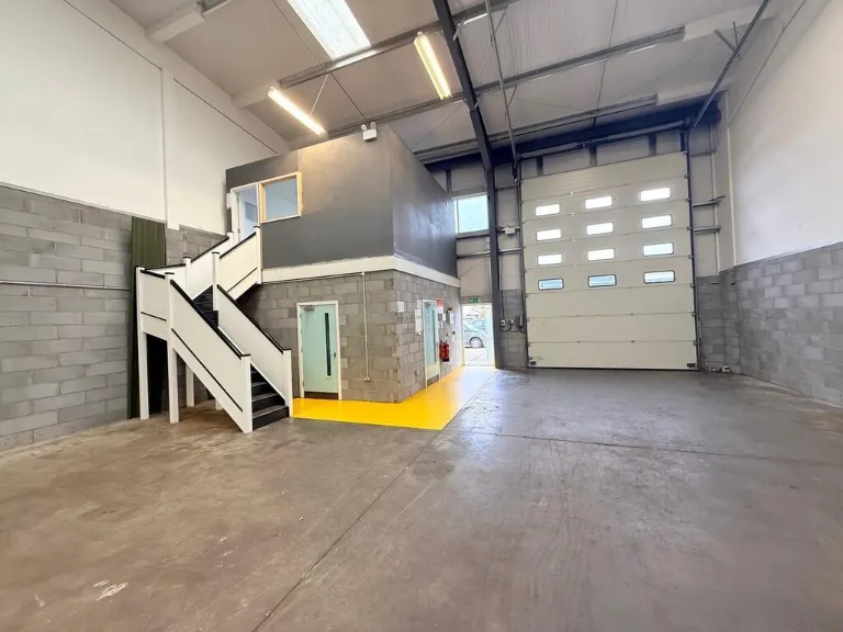
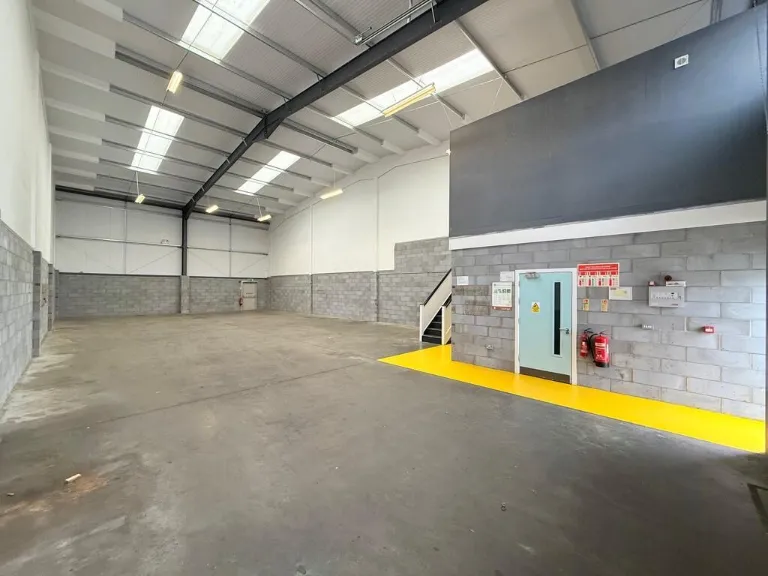
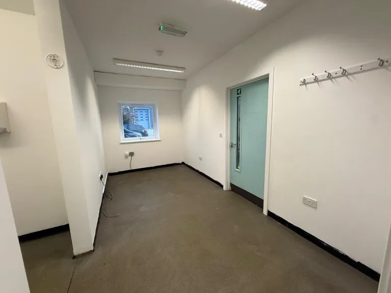
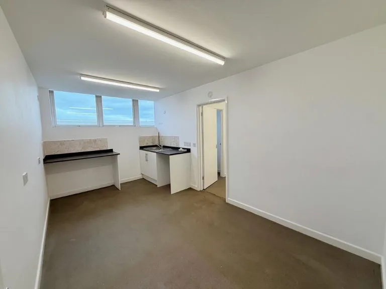
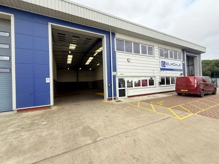
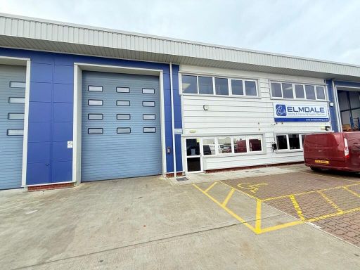
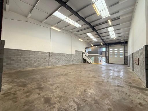
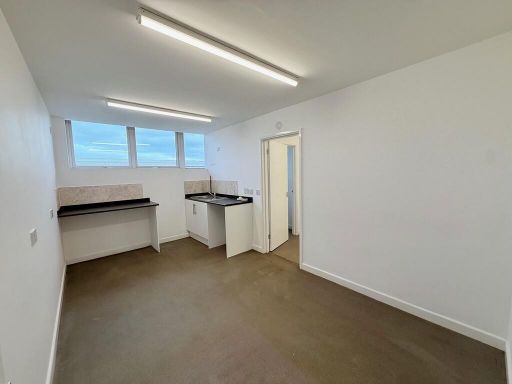
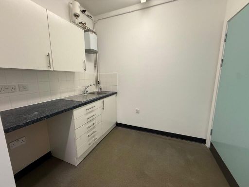
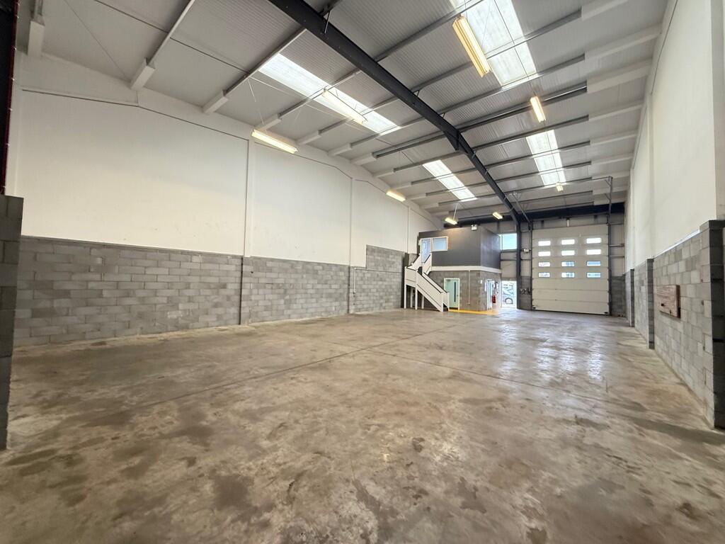
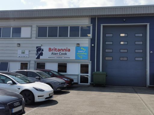
- Single high-quality commercial / business unit located on an industrial estate. Two-storey office frontage with a large roller shutter access to a clear-span warehouse with high eaves, concrete floor, blockwork lower walls and insulated roof with rooflights. Internal ground-floor office/ancillary rooms and kitchenette, plus first-floor mezzanine/office accessed by stairs. External yard/parking immediately to the front including marked disabled bay. Overall unit size appears large for an industrial unit (suitable for light industrial, storage/distribution or trade use). No residential features; no notable external views.
Image Descriptions
- commercial building modern industrial
- commercial warehouse industrial
Textual Property Features
Detected Visual Features
- commercial property
- industrial unit
- warehouse
- modern style
- office space
- loading bay
- roller door
- industrial
- commercial
- large space
- concrete floor
- high ceiling
- overhead lighting
- loading area
Nearby Schools
- Blundeston Church of England Voluntary Controlled Primary School
- Ormiston Cliff Park Primary Academy
- Cliff Park Ormiston Academy
- Moorlands CofE Primary Academy
- Woodlands Primary Academy
- Hillside Primary School
- Lynn Grove Academy
- St Nicholas Priory CofE VA Primary School
- Hopton Church of England Primary Academy
- St Mary and St Peter Catholic Primary School
- Cobholm Primary Academy
- Northgate Primary School
- Corton Church of England Voluntary Aided Primary School
- Ormiston Venture Academy
- Peterhouse CofE Primary Academy
- Homefield VC CofE Primary School
- Wroughton Infant Academy
- Wroughton Junior Academy
- Great Yarmouth Primary Academy
- Edward Worlledge Ormiston Academy
- Southtown Primary School
- St George's Primary School & St. George's Nursery School, Great Yarmouth
- Benjamin Britten Academy of Music and Mathematics
- Somerleyton Primary School
- Ormiston Herman Academy
- Stradbroke Primary Academy
Nearest General Shops
- Id: 2286053095
- Tags:
- Addr:
- City: Great Yarmouth
- Housenumber: 95
- Postcode: NR31 7AA
- Street: Magdalen Way
- Town: Gorleston
- Brand: Barnardo's
- Brand:wikidata: Q2884670
- Brand:wikipedia: en:Barnardo's
- Name: Barnardo's
- Shop: charity
- Source:
- TagsNormalized:
- Lat: 52.5734254
- Lon: 1.7145831
- FullGeoHash: u135p48w2svf
- PartitionGeoHash: u135
- Images:
- FoodStandards: null
- Distance: 1939.4
,- Id: 2286053096
- Tags:
- Addr:
- City: Great Yarmouth
- Housenumber: 97
- Postcode: NR31 7AA
- Street: Magdalen Way
- Town: Gorleston
- Name: Magdalen Video
- Shop: video
- Source:
- Wheelchair: yes
- TagsNormalized:
- Lat: 52.5733684
- Lon: 1.7145833
- FullGeoHash: u135p48w0djy
- PartitionGeoHash: u135
- Images:
- FoodStandards: null
- Distance: 1933.3
,- Id: 2286053100
- Tags:
- Addr:
- City: Great Yarmouth
- Housenumber: 99
- Postcode: NR31 7AA
- Street: Magdalen Way
- Town: Gorleston
- Fhrs:
- Name: Bushells
- Shop: bakery
- Source:
- Addr: FSA Food Hygiene Ratings Database
- Wheelchair: yes
- TagsNormalized:
- Lat: 52.573321
- Lon: 1.7145834
- FullGeoHash: u135p48tb9q5
- PartitionGeoHash: u135
- Images:
- FoodStandards:
- Id: 622003
- FHRSID: 622003
- LocalAuthorityBusinessID: 6483
- BusinessName: Bushell's Bakery
- BusinessType: Retailers - other
- BusinessTypeID: 4613
- AddressLine1: null
- AddressLine2: 99 Magdalen Way
- AddressLine3: Gorleston
- AddressLine4: Great Yarmouth, Norfolk
- PostCode: NR31 7AA
- RatingValue: 5
- RatingKey: fhrs_5_en-GB
- RatingDate: 2021-09-11
- LocalAuthorityCode: 229
- LocalAuthorityName: Great Yarmouth
- LocalAuthorityWebSite: http://www.great-yarmouth.gov.uk/live/index.htm
- LocalAuthorityEmailAddress: health@great-yarmouth.gov.uk
- Scores:
- Hygiene: 5
- Structural: 0
- ConfidenceInManagement: 0
- NewRatingPending: false
- Geocode:
- Longitude: 1.71463000000000
- Latitude: 52.57371500000000
- Distance: 1928.1
}
Nearest Religious buildings
- Id: 219448810
- Tags:
- Amenity: place_of_worship
- Building: church
- Denomination: methodist
- Name: Magdalen Way Methodisrt Church
- Religion: christian
- TagsNormalized:
- place of worship
- church
- methodist
- christian
- Lat: 52.5727523
- Lon: 1.7137414
- FullGeoHash: u135nfxfmp65
- PartitionGeoHash: u135
- Images:
- FoodStandards: null
- Distance: 1853.5
,- Id: 219448809
- Tags:
- Amenity: place_of_worship
- Building: church
- Denomination: anglican
- Listed_status: no
- Material: brick
- Name: Saint Mary Magdalene
- Religion: christian
- Service_times: Su 10:30-11:30,16:00-17:00; Su[2-4] 10:30-12:00; Su[2] 16:00-17:00; Tu 07:00-08:30; Th 14:30-16:00
- Tower: square
- Website: https://www.achurchnearyou.com/gorleston-st-mary-magdalene/
- Wikidata: Q105078687
- TagsNormalized:
- place of worship
- church
- anglican
- christian
- Lat: 52.5714219
- Lon: 1.7154096
- FullGeoHash: u135p434ezq4
- PartitionGeoHash: u135
- Images:
- FoodStandards: null
- Distance: 1739.8
,- Id: 5180285307
- Tags:
- Amenity: place_of_worship
- Denomination: anglo_baptist
- Indoor: yes
- Name: Cliff Park Community Church
- Religion: christian
- Service_times: Su 10:30
- Start_date: 1999
- Website: http://www.cpcc.org.uk/
- TagsNormalized:
- place of worship
- baptist
- church
- christian
- Lat: 52.5623755
- Lon: 1.7237377
- FullGeoHash: u135p0xnjbzz
- PartitionGeoHash: u135
- Images:
- FoodStandards: null
- Distance: 1264.8
}
Nearest Medical buildings
- Id: 2286053092
- Tags:
- Addr:
- City: Great Yarmouth
- Housenumber: 77
- Postcode: NR31 7AA
- Street: Magdalen Way
- Town: Gorleston
- Amenity: pharmacy
- Brand: Lloyds Pharmacy
- Brand:wikidata: Q6662870
- Brand:wikipedia: en:LloydsPharmacy
- Healthcare: pharmacy
- Name: Lloyds Pharmacy
- Source:
- Wheelchair: yes
- TagsNormalized:
- pharmacy
- lloyds pharmacy
- health
- healthcare
- Lat: 52.573885
- Lon: 1.7145821
- FullGeoHash: u135p4b90dmp
- PartitionGeoHash: u135
- Images:
- FoodStandards: null
- Distance: 1989
,- Id: 221378858
- Tags:
- Amenity: doctors
- Building: yes
- Name: Falkland's Surgery
- TagsNormalized:
- Lat: 52.5727765
- Lon: 1.7014365
- FullGeoHash: u135ndwfw7g5
- PartitionGeoHash: u135
- Images:
- FoodStandards: null
- Distance: 1860.3
,- Id: 323733
- Tags:
- Name: James Paget Hospital
- Naptan:
- StopAreaCode: 290G10101
- StopAreaType: GPBS
- Verified: no
- Public_transport: stop_area
- Source: naptan_import
- Type: public_transport
- TagsNormalized:
- Lat: 52.5625653
- Lon: 1.7216984
- FullGeoHash: u135p0txnkr7
- PartitionGeoHash: u135
- Images:
- FoodStandards: null
- Distance: 1161.2
,- Id: 220773458
- Tags:
- Amenity: hospital
- Healthcare: hospital
- Name: James Paget University Hospital
- Wikidata: Q14956745
- Wikipedia: en:James Paget University Hospital
- TagsNormalized:
- hospital
- health
- healthcare
- university
- Lat: 52.5617039
- Lon: 1.7154957
- FullGeoHash: u135p094jgy2
- PartitionGeoHash: u135
- Images:
- FoodStandards: null
- Distance: 782.3
}
Nearest Leisure Facilities
- Id: 946569514
- Tags:
- TagsNormalized:
- Lat: 52.5644212
- Lon: 1.7102294
- FullGeoHash: u135ncj3gnr6
- PartitionGeoHash: u135
- Images:
- FoodStandards: null
- Distance: 898.1
,- Id: 911563219
- Tags:
- Leisure: pitch
- Sport: bowls
- TagsNormalized:
- Lat: 52.5622537
- Lon: 1.7157183
- FullGeoHash: u135p09m74k2
- PartitionGeoHash: u135
- Images:
- FoodStandards: null
- Distance: 838.3
,- Id: 262049011
- Tags:
- Leisure: playground
- Name: Beacon Park Playground
- TagsNormalized:
- Lat: 52.560699
- Lon: 1.7132333
- FullGeoHash: u135nbrs30rq
- PartitionGeoHash: u135
- Images:
- FoodStandards: null
- Distance: 598.1
,- Id: 965578309
- Tags:
- Leisure: pitch
- Sport: basketball
- TagsNormalized:
- pitch
- leisure
- basketball
- sports
- Lat: 52.5607243
- Lon: 1.7128712
- FullGeoHash: u135nbrk2v1m
- PartitionGeoHash: u135
- Images:
- FoodStandards: null
- Distance: 585.4
,- Id: 965578308
- Tags:
- Leisure: pitch
- Sport: skateboard
- TagsNormalized:
- pitch
- leisure
- skateboard
- sports
- Lat: 52.5607683
- Lon: 1.7125845
- FullGeoHash: u135nbrhdj7e
- PartitionGeoHash: u135
- Images:
- FoodStandards: null
- Distance: 578.1
}
Nearest Tourist attractions
- Id: 976484808
- Tags:
- Name: Haven Hopton Holiday Village
- Tourism: caravan_site
- TagsNormalized:
- Lat: 52.5414956
- Lon: 1.7322548
- FullGeoHash: u134zkvkkkwv
- PartitionGeoHash: u134
- Images:
- FoodStandards: null
- Distance: 2351.6
,- Id: 1625186
- Tags:
- Name: Hopton Holiday Village
- Tourism: caravan_site
- Type: multipolygon
- Website: http://www.hoptonholidayvillage.co.uk/
- TagsNormalized:
- Lat: 52.5414956
- Lon: 1.7322548
- FullGeoHash: u134zkvkkkwv
- PartitionGeoHash: u134
- Images:
- FoodStandards: null
- Distance: 2351.6
,- Id: 1086047928
- Tags:
- Addr:
- City: Great Yarmouth
- Housenumber: 19
- Street: Marine Parade
- Town: Gorleston
- Building: yes
- Name: Midway Holiday Flats
- Source:
- Tourism: apartment
- Website: https://www.midwayholidayflats.com/
- TagsNormalized:
- Lat: 52.5665001
- Lon: 1.729583
- FullGeoHash: u135p37qn1ye
- PartitionGeoHash: u135
- Images:
- FoodStandards: null
- Distance: 1849.8
}
Nearest Train stations
- Id: 263373872
- Tags:
- Name: Oulton Broad South
- Naptan:
- Network: National Rail
- Old_name: Carlton Colville
- Public_transport: station
- Railway: station
- Ref:
- Wikidata: Q1870239
- Wikipedia: en:Oulton Broad South railway station
- TagsNormalized:
- Lat: 52.4695869
- Lon: 1.7074886
- FullGeoHash: u134qzg37rgv
- PartitionGeoHash: u134
- Images:
- FoodStandards: null
- Distance: 9663.1
,- Id: 252753813
- Tags:
- Name: Lowestoft
- Naptan:
- Network: National Rail
- Old_name: Lowestoft Central
- Public_transport: station
- Railway: station
- Ref:
- Wheelchair: yes
- Wikidata: Q2008297
- Wikipedia: en:Lowestoft railway station
- TagsNormalized:
- Lat: 52.47424
- Lon: 1.7499873
- FullGeoHash: u134xbdk9em4
- PartitionGeoHash: u134
- Images:
- FoodStandards: null
- Distance: 9582.3
,- Id: 252745593
- Tags:
- Name: Oulton Broad North
- Naptan:
- Network: National Rail
- Public_transport: station
- Railway: station
- Ref:
- Source: NPE
- Wikidata: Q2854239
- Wikipedia: en:Oulton Broad North railway station
- TagsNormalized:
- Lat: 52.4777293
- Lon: 1.7161761
- FullGeoHash: u134x138vvc8
- PartitionGeoHash: u134
- Images:
- FoodStandards: null
- Distance: 8776.3
,- Id: 263373156
- Tags:
- Name: Somerleyton
- Naptan:
- Network: National Rail
- Public_transport: station
- Railway: station
- Ref:
- Source: NPE
- Wikidata: Q1920909
- Wikipedia: en:Somerleyton railway station
- TagsNormalized:
- Lat: 52.5101587
- Lon: 1.6521998
- FullGeoHash: u134tx5jg513
- PartitionGeoHash: u134
- Images:
- FoodStandards: null
- Distance: 6375.5
,- Id: 1699243929
- Tags:
- Name: Great Yarmouth
- Name:lt: Didysis Jarmutas
- Naptan:
- Network: National Rail
- Operator: Greater Anglia
- Platforms: 4
- Public_transport: station
- Railway: station
- Ref:
- Wikidata: Q280999
- Wikipedia: en:Great Yarmouth railway station
- TagsNormalized:
- Lat: 52.6119213
- Lon: 1.7206879
- FullGeoHash: u135r1sywuvz
- PartitionGeoHash: u135
- Images:
- FoodStandards: null
- Distance: 6225.7
}
Nearest Hotels
- Id: 182378351
- Tags:
- Addr:
- City: Great Yarmouth
- Place: South Pier
- Postcode: NR31 6PL
- Town: Gorleston
- Building: hotel
- Fhrs:
- Name: The Pier Hotel
- Source:
- Tourism: hotel
- Wheelchair: yes
- Wheelchair:description: car park has 2 blue badge spaces
- TagsNormalized:
- Lat: 52.5709988
- Lon: 1.7338326
- FullGeoHash: u135p6q830rr
- PartitionGeoHash: u135
- Images:
- FoodStandards: null
- Distance: 2391
,- Id: 223804728
- Tags:
- Addr:
- City: Great Yarmouth
- Postcode: NR31 6DH
- Street: Cliff Hill
- Town: Gorleston-On-Sea
- Building: yes
- Name: Cliff Hotel
- Tourism: hotel
- Website: https://www.thecliffhotel.co.uk/
- Wheelchair: yes
- TagsNormalized:
- Lat: 52.5707166
- Lon: 1.7310896
- FullGeoHash: u135p6hw97cg
- PartitionGeoHash: u135
- Images:
- FoodStandards: null
- Distance: 2235.3
,- Id: 207742637
- Tags:
- Addr:
- Brand: Travelodge
- Brand:wikidata: Q9361374
- Brand:wikipedia: en:Travelodge UK
- Building: hotel
- Fhrs:
- Internet_access: wlan
- Internet_access:fee: customers
- Internet_access:ssid: Travelodge WiFi
- Name: Travelodge
- Tourism: hotel
- TagsNormalized:
- Lat: 52.556437
- Lon: 1.7152648
- FullGeoHash: u134zp952tfn
- PartitionGeoHash: u134
- Images:
- FoodStandards: null
- Distance: 509.6
}
Tags
- commercial property
- industrial unit
- warehouse
- modern style
- office space
- loading bay
- roller door
- industrial
- warehouse
- commercial
- large space
- concrete floor
- high ceiling
- overhead lighting
- roller door
- loading area
Local Market Stats
- Average Price/sqft: £237
- Avg Income: £36700
- Rental Yield: 4.1%
- Social Housing: 6%
- Planning Success Rate: 86%
Similar Properties
 Light industrial facility for sale in Unit 2 Blackfriars Court, Excalibur Road, Great Yarmouth, Norfolk, NR31 7RQ, NR31 — £395,000 • 1 bed • 1 bath • 3660 ft²
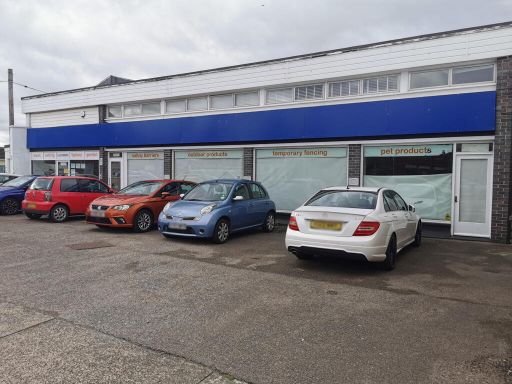 Warehouse for sale in 27-31 Caister Road, Great Yarmouth, Norfolk, NR30 4DA, NR30 — £600,000 • 1 bed • 1 bath • 10428 ft²
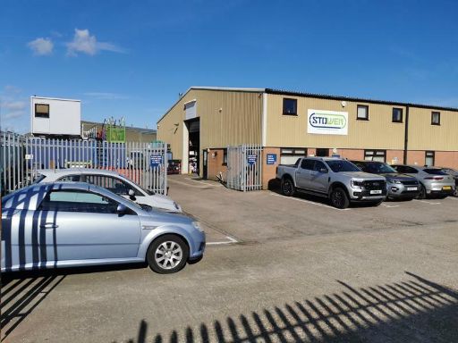 Light industrial facility for sale in Unit 1, James Watt Close, Great Yarmouth, Norfolk, NR31 0NX, NR31 — £500,000 • 1 bed • 1 bath • 5278 ft²
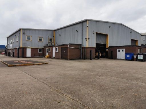 Light industrial facility for sale in Units 3 & 4, Marine Park, Gapton Hall Road, Great Yarmouth, Norfolk, NR31 0NL, NR31 — £2,750,000 • 1 bed • 1 bath • 22841 ft²
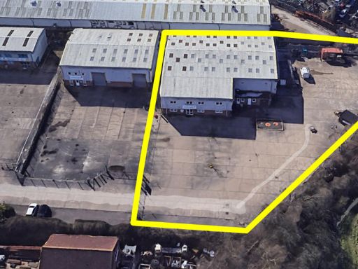 Light industrial facility for sale in Unit 4, Marine Park, Gapton Hall Road, Great Yarmouth, Norfolk, NR31 0NL, NR31 — £1,950,000 • 1 bed • 1 bath • 14908 ft²
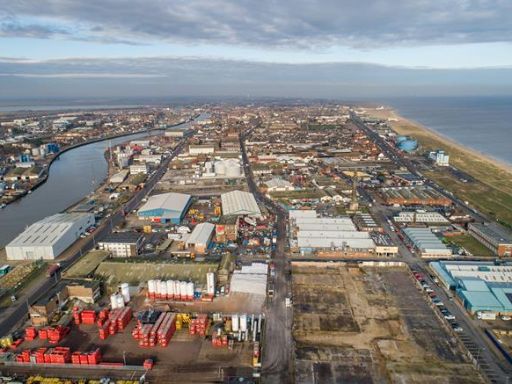 Light industrial facility for sale in Great Yarmouth Energy Park, South Denes Road, Great Yarmouth, Norfolk, NR30 — £150,000 • 1 bed • 1 bath
Meta
- {
"@context": "https://schema.org",
"@type": "Residence",
"name": "Light industrial facility for sale in Excalibur Road, Gorle…",
"description": "",
"url": "https://propertypiper.co.uk/property/4c7cfa80-d267-4e1f-a9f6-578c32bd4e43",
"image": "https://image-a.propertypiper.co.uk/d2c85b5f-28ac-4c0a-8b66-ae3d19cf31a0-1024.jpeg",
"address": {
"@type": "PostalAddress",
"streetAddress": "UNIT 8, BLACKFRIARS COURT, EXCALIBUR ROAD",
"postalCode": "NR31 7RQ",
"addressLocality": "Great Yarmouth",
"addressRegion": "Great Yarmouth",
"addressCountry": "England"
},
"geo": {
"@type": "GeoCoordinates",
"latitude": 52.55648911130265,
"longitude": 1.7077273050371988
},
"numberOfRooms": 1,
"numberOfBathroomsTotal": 1,
"floorSize": {
"@type": "QuantitativeValue",
"value": 3269,
"unitCode": "FTK"
},
"offers": {
"@type": "Offer",
"price": 350000,
"priceCurrency": "GBP",
"availability": "https://schema.org/InStock"
},
"additionalProperty": [
{
"@type": "PropertyValue",
"name": "Feature",
"value": "commercial property"
},
{
"@type": "PropertyValue",
"name": "Feature",
"value": "industrial unit"
},
{
"@type": "PropertyValue",
"name": "Feature",
"value": "warehouse"
},
{
"@type": "PropertyValue",
"name": "Feature",
"value": "modern style"
},
{
"@type": "PropertyValue",
"name": "Feature",
"value": "office space"
},
{
"@type": "PropertyValue",
"name": "Feature",
"value": "loading bay"
},
{
"@type": "PropertyValue",
"name": "Feature",
"value": "roller door"
},
{
"@type": "PropertyValue",
"name": "Feature",
"value": "industrial"
},
{
"@type": "PropertyValue",
"name": "Feature",
"value": "warehouse"
},
{
"@type": "PropertyValue",
"name": "Feature",
"value": "commercial"
},
{
"@type": "PropertyValue",
"name": "Feature",
"value": "large space"
},
{
"@type": "PropertyValue",
"name": "Feature",
"value": "concrete floor"
},
{
"@type": "PropertyValue",
"name": "Feature",
"value": "high ceiling"
},
{
"@type": "PropertyValue",
"name": "Feature",
"value": "overhead lighting"
},
{
"@type": "PropertyValue",
"name": "Feature",
"value": "roller door"
},
{
"@type": "PropertyValue",
"name": "Feature",
"value": "loading area"
}
]
}