NW7 4JN - 5 bedroom detached house for sale in The Reddings, Mill Hil…
View on Property Piper
5 bedroom detached house for sale in The Reddings, Mill Hill, NW7
Property Details
- Price: £1595000
- Bedrooms: 5
- Bathrooms: 5
- Property Type: undefined
- Property SubType: undefined
Brochure Descriptions
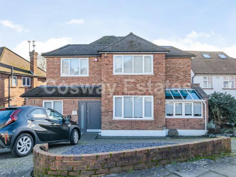
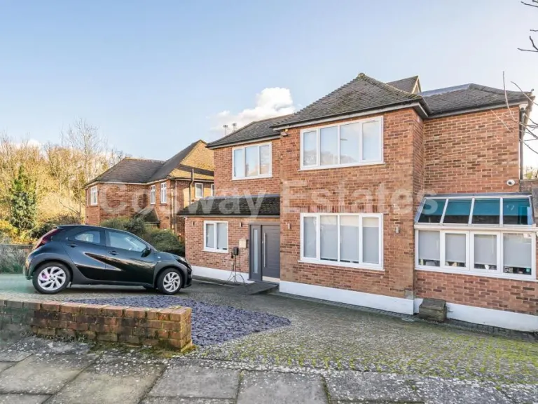
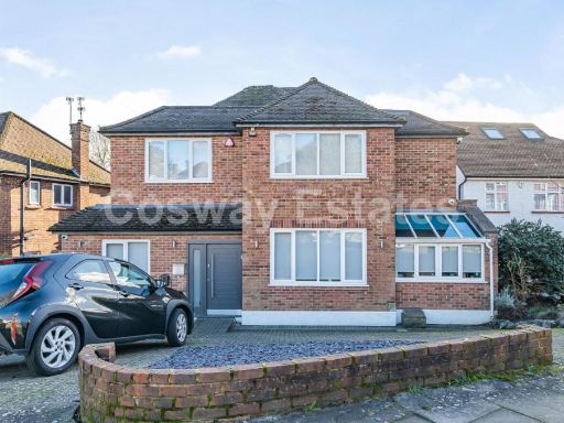
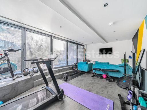
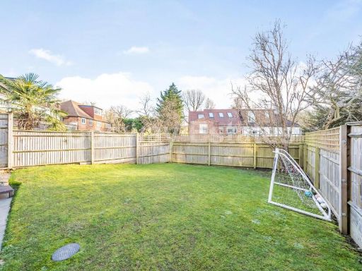
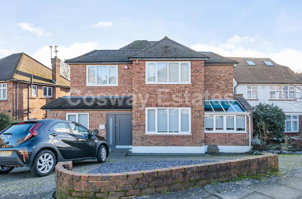
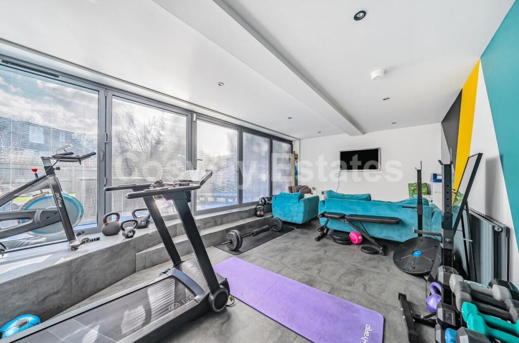
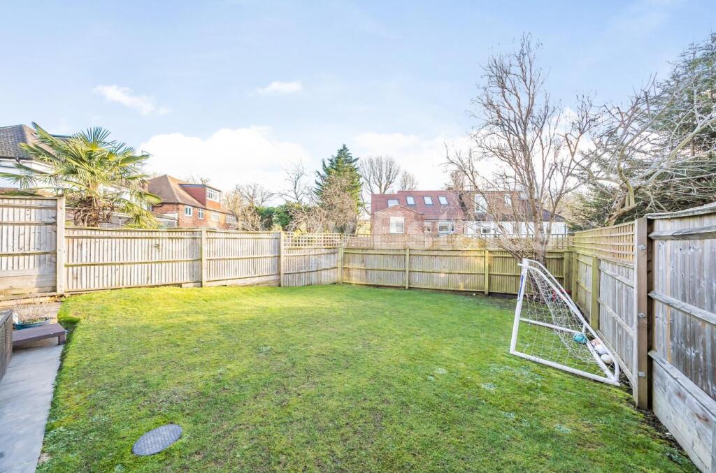
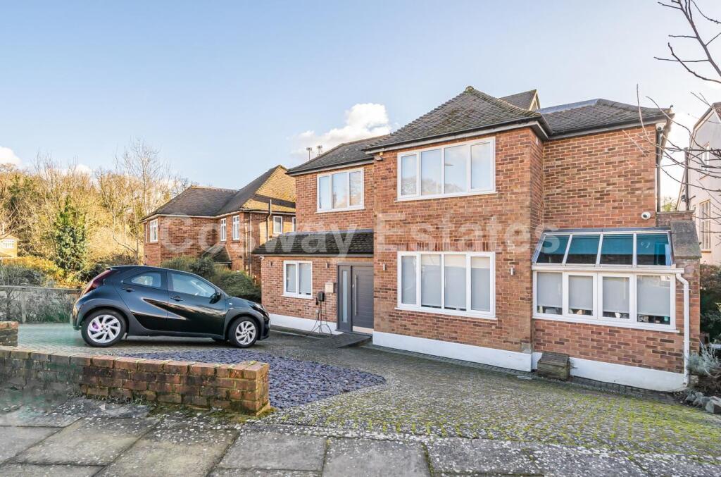
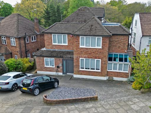
- Large detached two‑storey brick family house on a suburban street in Mill Hill. The front elevation presents a symmetrical double‑fronted facade with a covered entrance, wide driveway providing off‑street parking for multiple cars behind a low brick boundary wall, and a side glazed conservatory/sunroom. The house appears to offer generous internal proportions (advertised as five bedrooms and multiple reception spaces) with a lower‑ground multi‑use room/gym. Garden space to the front is small; rear garden not visible in the images. The property sits in a residential neighbourhood close to local high street amenities and transport links. Overall plot and house size read as substantial for a family home in this area.
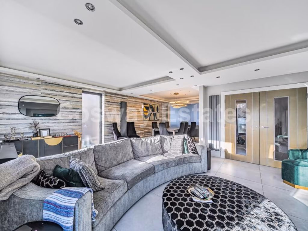
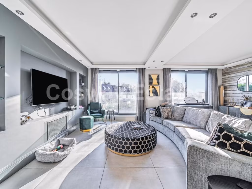
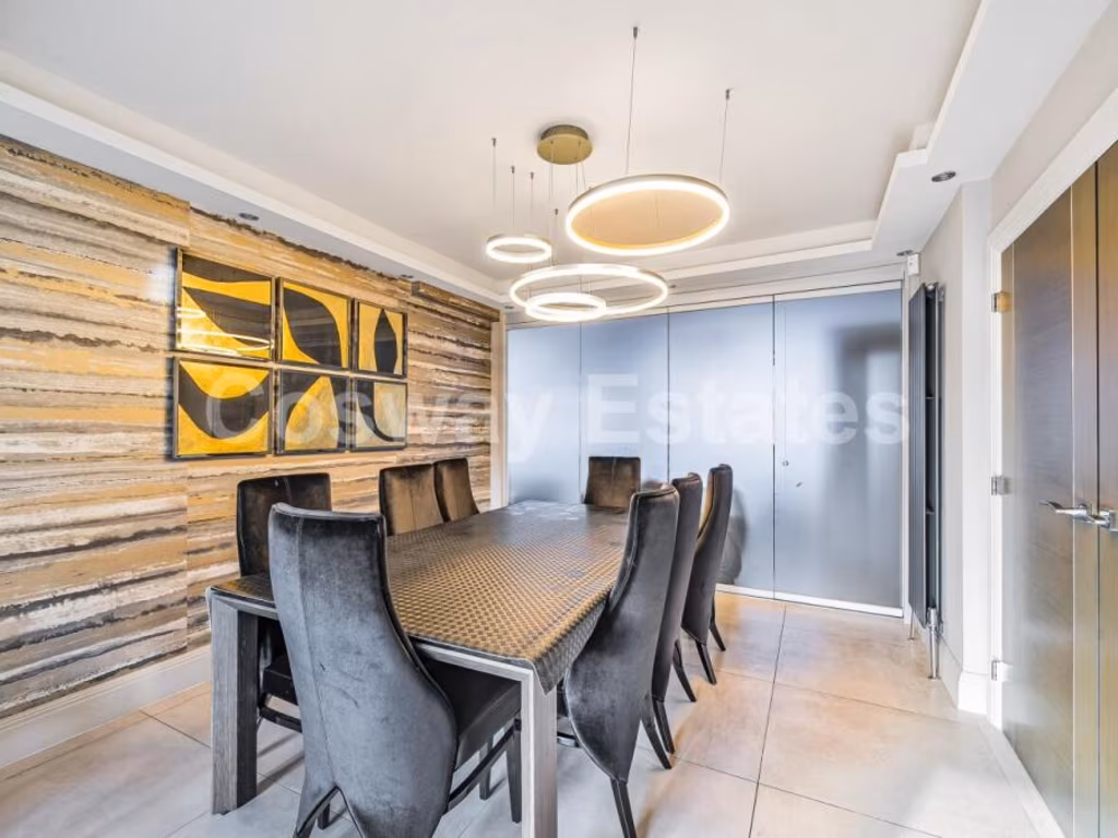
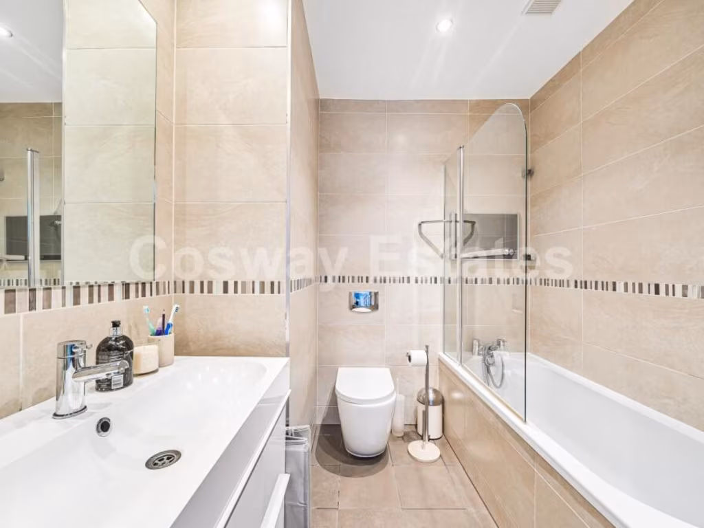
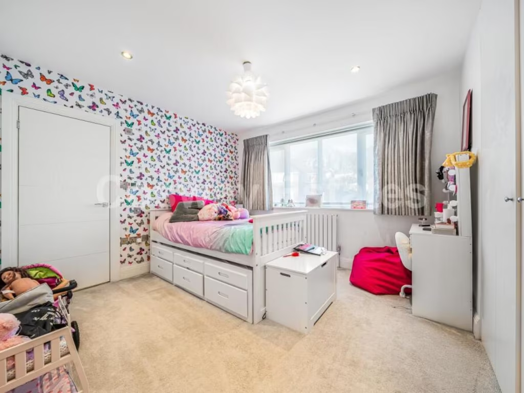
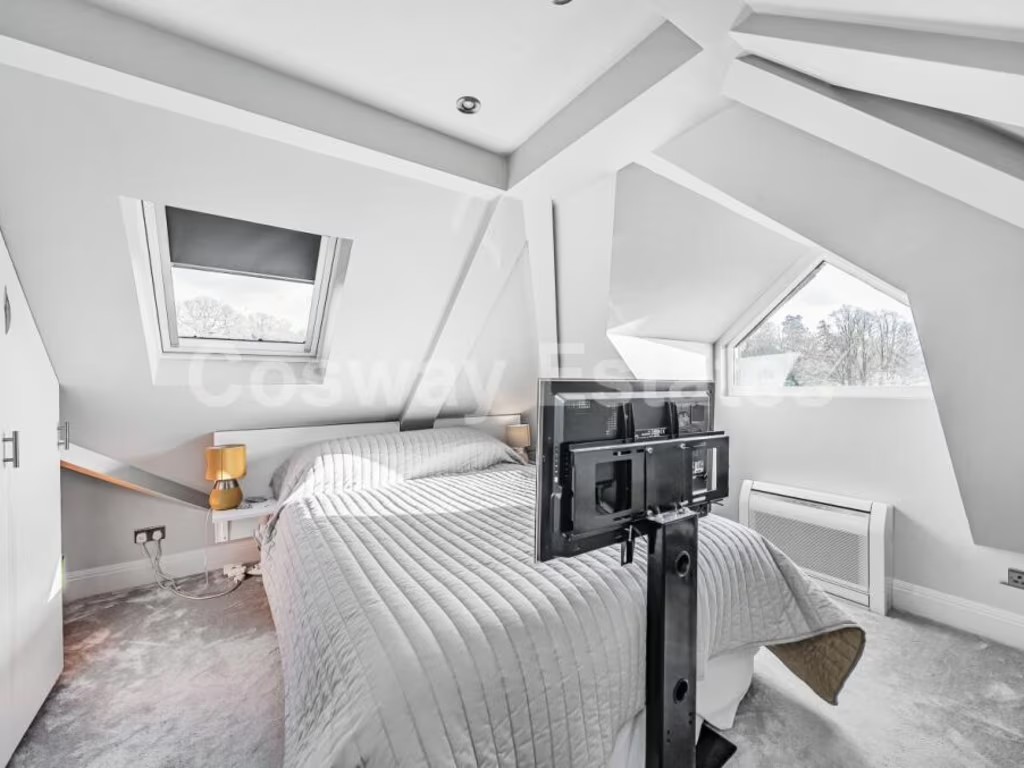
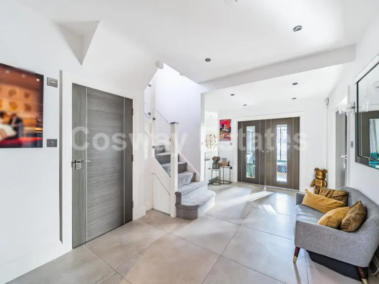
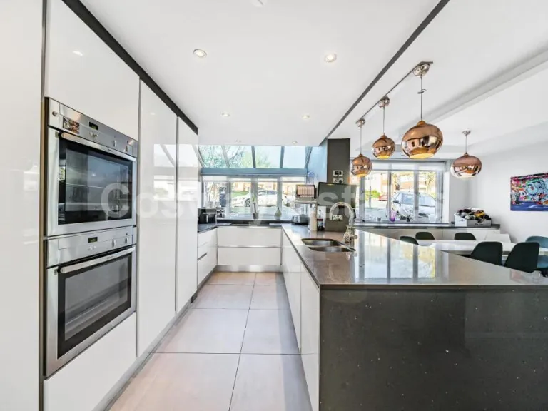
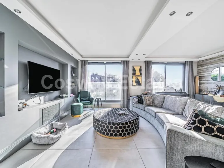
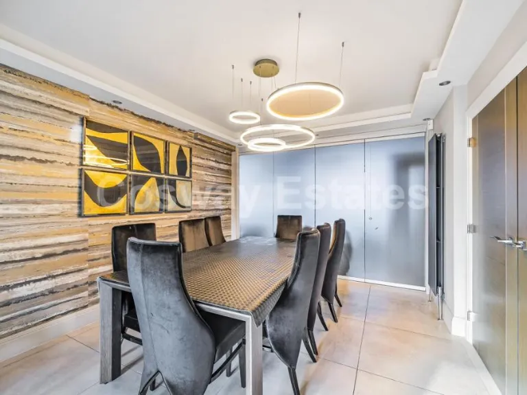
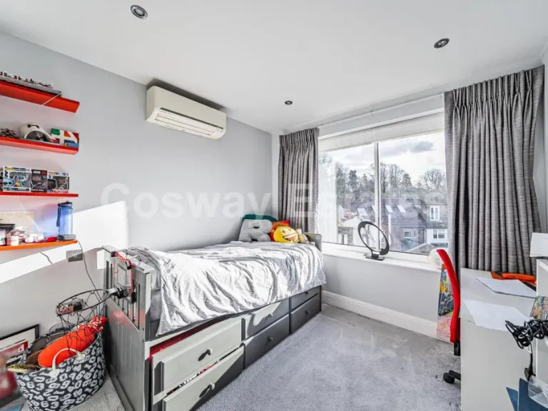
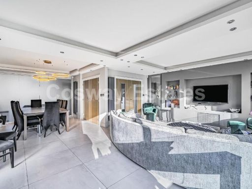
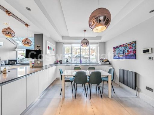
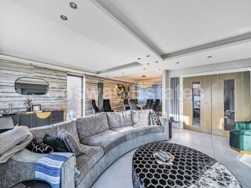
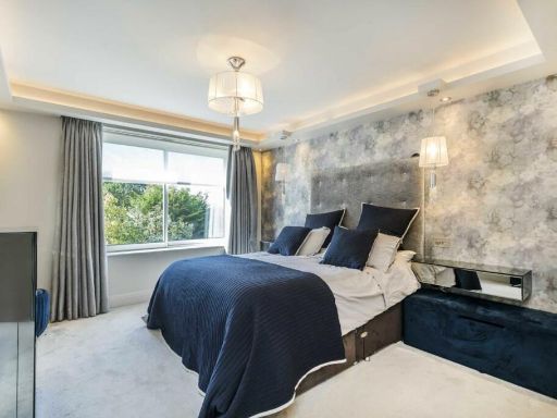
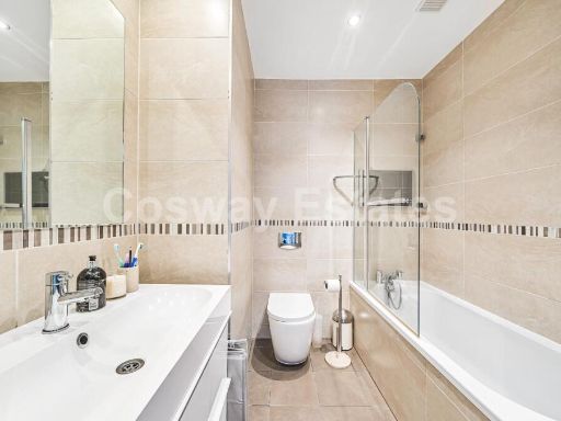
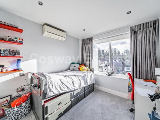
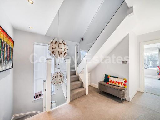
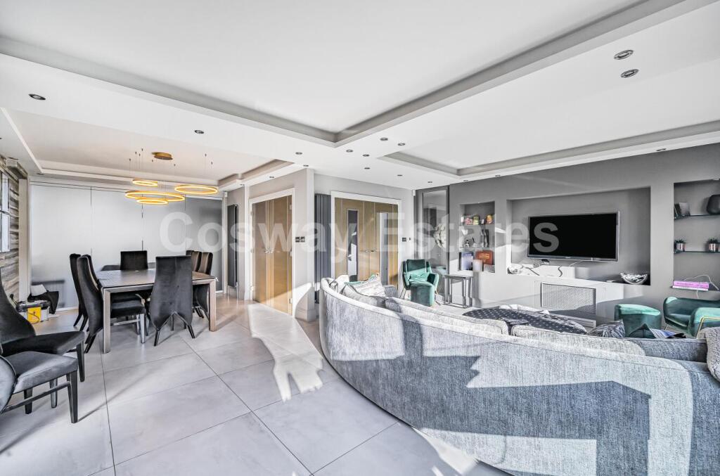
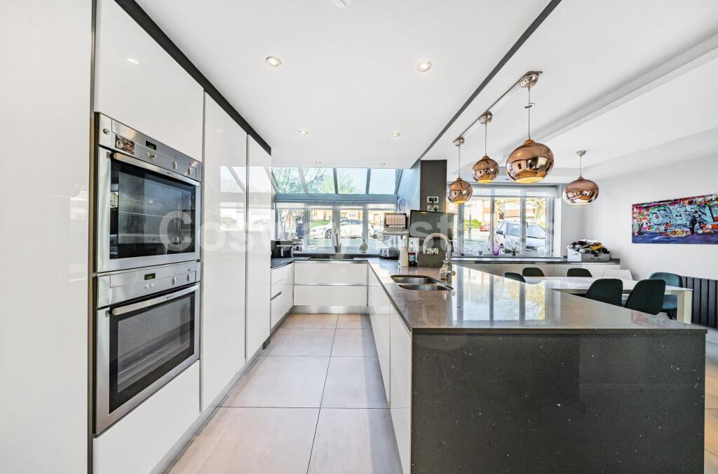
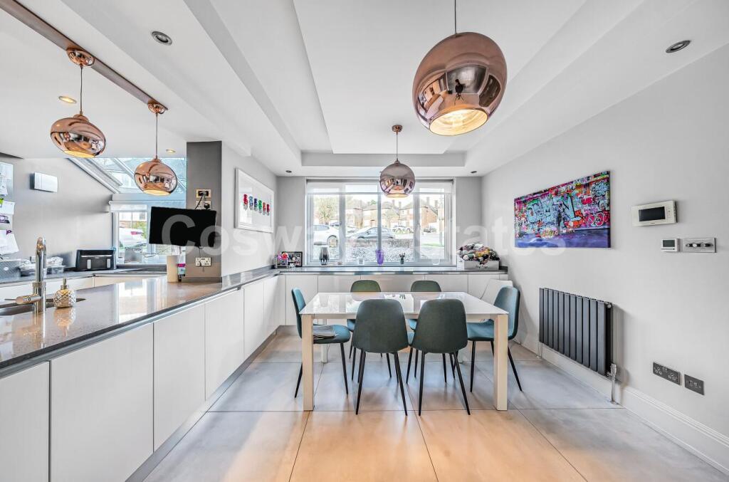
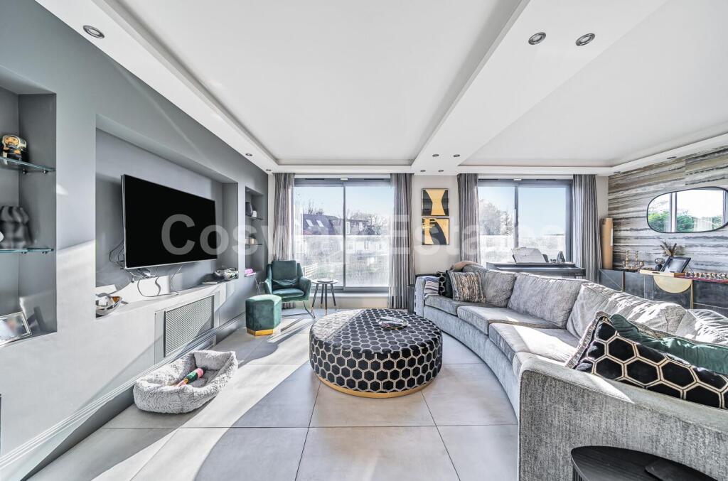
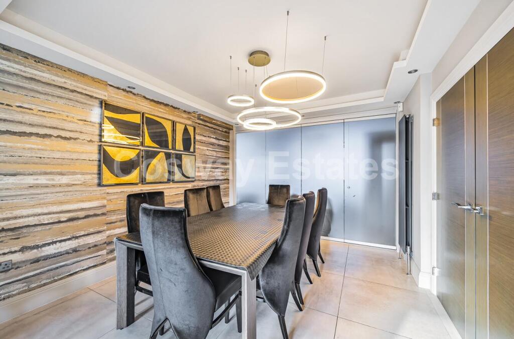
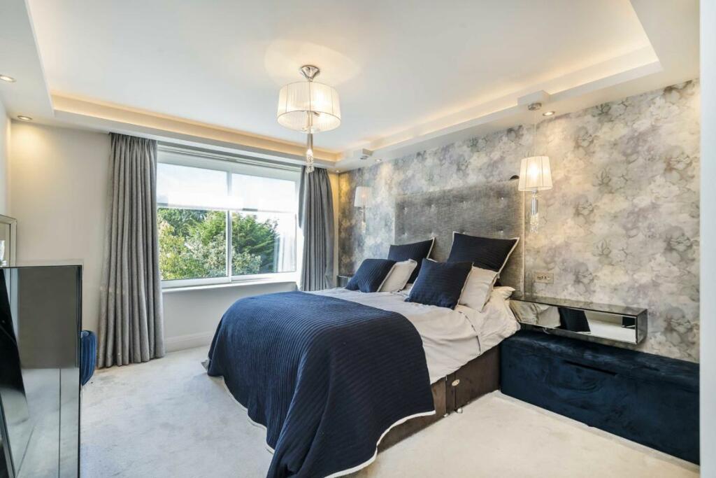
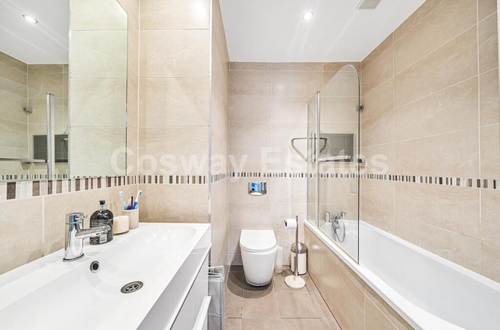
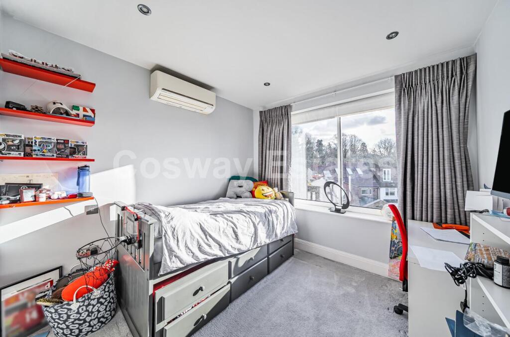
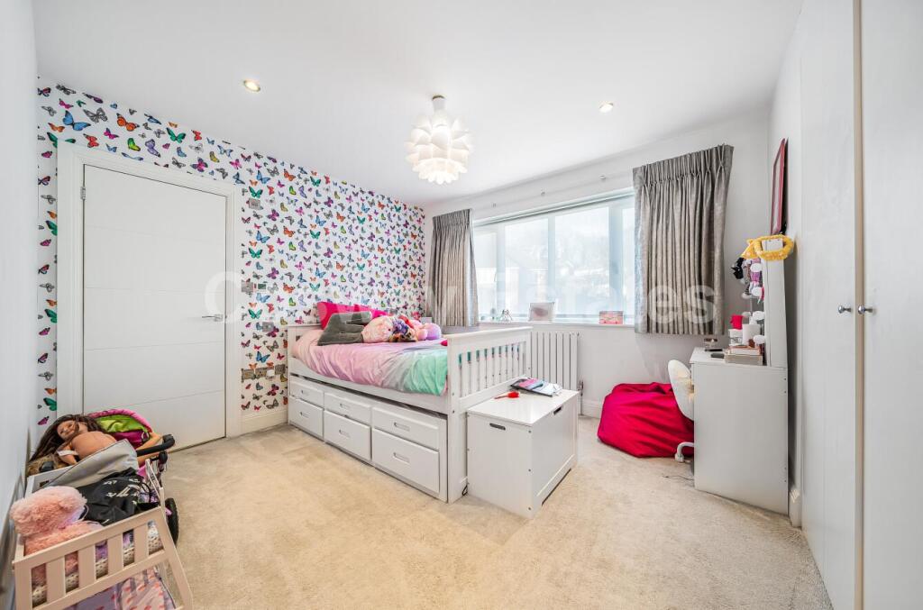
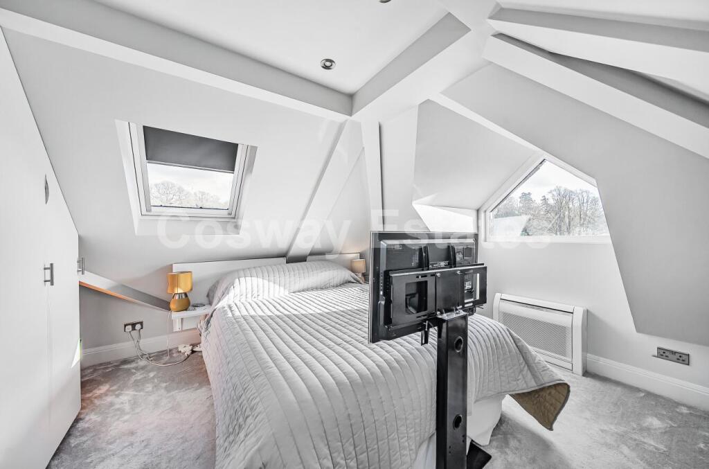
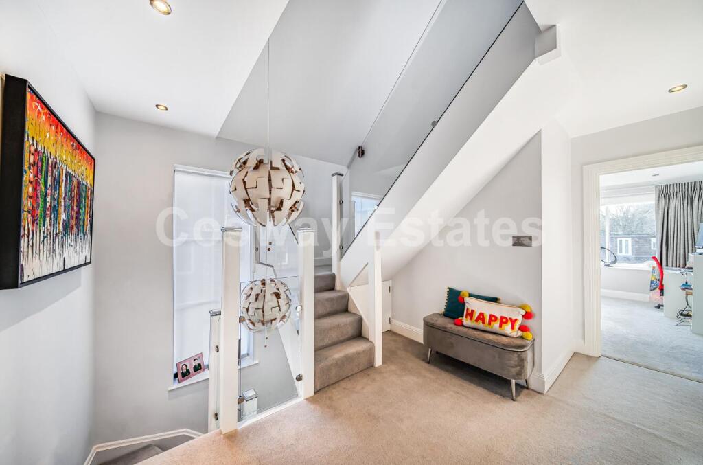
- Large, modern detached family house presented in contemporary finish across multiple floors. The layout (from the floorplan and photos) indicates substantial open-plan living accommodation with a generous kitchen / island and dining area opening into a spacious family / reception room, plus additional reception spaces. The property appears to have several bedrooms and multiple bathrooms over first and second floors (indicative of a sizeable family home). Interior specification looks high-end with tiled floors, integrated appliances, recessed lighting and contemporary fixtures. There is an external garden area (size not precisely shown) and the overall plot appears large for an urban/suburban setting. No notable views (sea/river/mountain) are visible in the images provided.
Image Descriptions
- detached house modern suburban
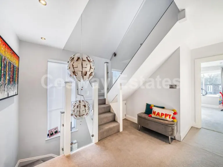
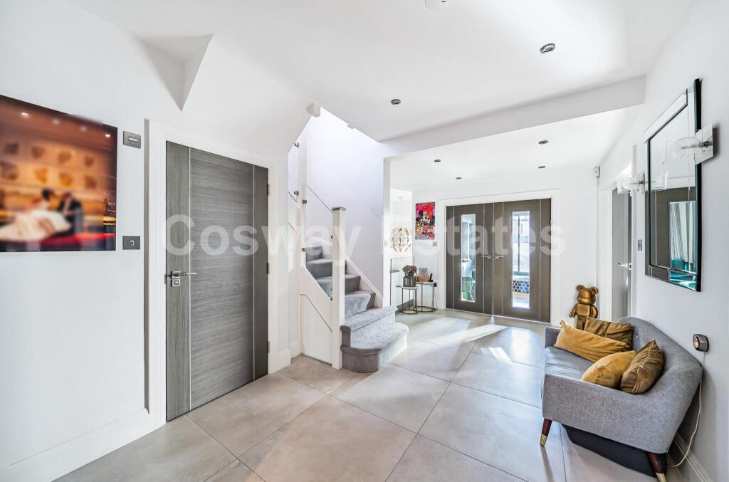
- entryway contemporary
Floorplan Description
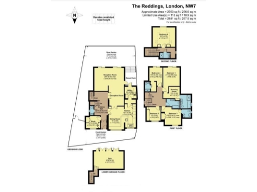
- Multi-floor house with lower ground gym, ground-floor reception/dining/kitchen/study, first-floor bedrooms and second-floor bedroom
Rooms
- Reception Room: large
- Dining Room: average
- Kitchen: average
- Study: small
- Utility: small
- Bedroom 1: large
- Bedroom 2: large
- Bedroom 3: average
- Bedroom 4: average
- Dressing Room: small
- Bedroom (Second Floor): large
- Gym: large
Textual Property Features
Detected Visual Features
- detached house
- brick exterior
- modern style
- double-story
- driveway
- residential area
- contemporary
- entryway
- modern
- bright
- neutral tones
- tiled flooring
- staircase
- open layout
EPC Details
- Fully double glazed
- Cavity wall, filled cavity
- Boiler and radiators, mains gas
- Low energy lighting in all fixed outlets
- Suspended, insulated
Nearby Schools
- Goodwyn School
- The Annunciation Catholic Infant School
- The Annunciation RC Junior School
- The Orion Primary School
- Copthall School
- Etz Chaim Jewish Primary School
- St Martin's School
- Goldbeaters Primary School
- Menorah Foundation School
- Woodcroft Primary School
- Deansbrook Junior School
- Mathilda Marks-Kennedy Jewish Primary School
- Beit Shvidler Primary School
- Saracens High School
- St James' Catholic High School
- Blessed Dominic Catholic Primary School
- Hasmonean High School for Girls
- St Vincent's Catholic Primary School
- Mill Hill School Foundation
- Deansbrook Infant School
- Rosh Pinah Primary School
- Courtland School
- St Paul's CofE Primary School NW7
- Ellern Mede School Limited
- Mill Hill County High School
- Menorah Grammar School
- Fairway Primary School and Children's Centre
- Saffron Green Primary School
Nearest Bars And Restaurants
- Id: 5749897918
- Tags:
- Amenity: cafe
- Name: Brewed+Pressed
- TagsNormalized:
- Lat: 51.6156301
- Lon: -0.2454451
- FullGeoHash: gcpvdkm6bdyf
- PartitionGeoHash: gcpv
- Images:
- FoodStandards: null
- Distance: 893.4
,- Id: 5749897911
- Tags:
- Amenity: fast_food
- Cuisine: chinese
- TagsNormalized:
- Lat: 51.6158534
- Lon: -0.2452691
- FullGeoHash: gcpvdkmkhu6n
- PartitionGeoHash: gcpv
- Images:
- FoodStandards: null
- Distance: 865.9
,- Id: 5749897897
- Tags:
- Amenity: restaurant
- Cuisine: pizza
- Level: 0
- Name: Pizza Express
- Toilets: yes
- Toilets:access: customers
- TagsNormalized:
- Lat: 51.6158117
- Lon: -0.2447111
- FullGeoHash: gcpvdkmgcudn
- PartitionGeoHash: gcpv
- Images:
- FoodStandards: null
- Distance: 857.8
,- Id: 813087122
- Tags:
- Alt_name: Three Hammers Public House
- Amenity: pub
- Building: yes
- Name: The Three Hammers
- Toilets: yes
- Toilets:access: customers
- TagsNormalized:
- Lat: 51.621437
- Lon: -0.233887
- FullGeoHash: gcpvdtmswj34
- PartitionGeoHash: gcpv
- Images:
- FoodStandards: null
- Distance: 524
,- Id: 543124606
- Tags:
- Amenity: pub
- Building: yes
- Name: The Rising Sun
- Wikidata: Q17361864
- Wikipedia: en:Rising Sun, Mill Hill
- TagsNormalized:
- Lat: 51.6271027
- Lon: -0.2418339
- FullGeoHash: gcpvdqrvsv7x
- PartitionGeoHash: gcpv
- Images:
- FoodStandards: null
- Distance: 442.2
}
Nearest General Shops
- Id: 5749897915
- Tags:
- Level: 0
- Name: HC Med Spa
- Shop: beauty
- TagsNormalized:
- Lat: 51.6154312
- Lon: -0.2456473
- FullGeoHash: gcpvdkm1sjb0
- PartitionGeoHash: gcpv
- Images:
- FoodStandards: null
- Distance: 919
,- Id: 5749897902
- Tags:
- Level: 0
- Name: Yummies Deli & Bagel
- Shop: deli
- TagsNormalized:
- Lat: 51.6156779
- Lon: -0.2453983
- FullGeoHash: gcpvdkm71g9z
- PartitionGeoHash: gcpv
- Images:
- FoodStandards: null
- Distance: 887.3
,- Id: 5749897907
- Tags:
- Beauty: nails
- Level: 0
- Name: ES Nails
- Shop: beauty
- TagsNormalized:
- Lat: 51.6157176
- Lon: -0.2453559
- FullGeoHash: gcpvdkm76g1k
- PartitionGeoHash: gcpv
- Images:
- FoodStandards: null
- Distance: 882.2
}
Nearest Grocery shops
- Id: 911005244
- Tags:
- Brand: Shell Select
- Brand:wikidata: Q154950
- Brand:wikipedia: en:Royal Dutch Shell
- Building: yes
- Name: Shell Select
- Shop: convenience
- TagsNormalized:
- shell
- shell select
- convenience
- shop
- Lat: 51.6223169
- Lon: -0.2551966
- FullGeoHash: gcpvdjw1v3re
- PartitionGeoHash: gcpv
- Images:
- FoodStandards: null
- Distance: 988
,- Id: 5762034702
- Tags:
- Name: Rota Express
- Shop: convenience
- TagsNormalized:
- Lat: 51.6149019
- Lon: -0.246172
- FullGeoHash: gcpvdkhwxg0f
- PartitionGeoHash: gcpv
- Images:
- FoodStandards: null
- Distance: 987
,- Id: 5749897905
- Tags:
- Level: 0
- Name: Broadway News
- Shop: convenience
- TagsNormalized:
- Lat: 51.6153092
- Lon: -0.2457948
- FullGeoHash: gcpvdkm0bx40
- PartitionGeoHash: gcpv
- Images:
- FoodStandards: null
- Distance: 935.3
}
Nearest Supermarkets
- Id: 166129315
- Tags:
- Brand: Waitrose
- Brand:wikidata: Q771734
- Brand:wikipedia: en:Waitrose & Partners
- Building: retail
- Name: Waitrose
- Official_name: Waitrose & Partners
- Operator: Waitrose & Partners
- Phone: +44 20 8371 8248
- Shop: supermarket
- Wheelchair: yes
- TagsNormalized:
- waitrose
- retail
- supermarket
- shop
- Lat: 51.6072399
- Lon: -0.2090457
- FullGeoHash: gcpve4zcbyu1
- PartitionGeoHash: gcpv
- Images:
- FoodStandards: null
- Distance: 2826.3
,- Id: 228952705
- Tags:
- Addr:
- City: Edgware
- Housename: Broadwalk Shopping Centre
- Postcode: HA8 7BQ
- Street: Station Road
- Atm: yes
- Branch: Edgware Superstore
- Brand: Sainsbury's
- Brand:wikidata: Q152096
- Brand:wikipedia: en:Sainsbury's
- Name: Sainsbury's
- Opening_hours: Mo-Sa 07:00-22:00; Su 11:00-17:00; 2017 May 29 08:00-19:00
- Opening_hours:url: https://stores.sainsburys.co.uk/0515/edgware
- Phone: +44 20 8905 6066
- Shop: supermarket
- Website: https://stores.sainsburys.co.uk/0515/edgware
- TagsNormalized:
- atm
- sainsburys
- supermarket
- shop
- Lat: 51.6117303
- Lon: -0.2758021
- FullGeoHash: gcpv9exhj7g5
- PartitionGeoHash: gcpv
- Images:
- FoodStandards: null
- Distance: 2721.5
,- Id: 8902814
- Tags:
- Addr:
- City: Borehamwood
- Postcode: WD6 2RN
- Street: Stirling Way
- Brand: Morrisons
- Brand:wikidata: Q922344
- Brand:wikipedia: en:Morrisons
- Building: retail
- Contact:
- Website: https://my.morrisons.com/storefinder/388
- Landuse: retail
- Name: Morrisons
- Opening_hours: Mo-Sa 07:00-23:00; Su 10:00-16:00
- Operator: Morrisons
- Payment:
- Cards: yes
- Cash: yes
- Coins: yes
- Shop: supermarket
- Toilets:
- Wheelchair: yes
- TagsNormalized:
- morrisons
- retail
- supermarket
- shop
- Lat: 51.6443448
- Lon: -0.2561003
- FullGeoHash: gcpvf1td07tu
- PartitionGeoHash: gcpv
- Images:
- FoodStandards: null
- Distance: 2576.8
}
Nearest Religious buildings
- Id: 82489306
- Tags:
- Amenity: place_of_worship
- Building: yes
- Denomination: roman_catholic
- Name: Sacred Heart & Mary Immaculate
- Religion: christian
- Source: OS_OpenData_StreetView
- TagsNormalized:
- place of worship
- catholic
- roman catholic
- christian
- church
- Lat: 51.6150787
- Lon: -0.2454145
- FullGeoHash: gcpvdkjr9kj9
- PartitionGeoHash: gcpv
- Images:
- FoodStandards: null
- Distance: 950.5
,- Id: 82489307
- Tags:
- Amenity: place_of_worship
- Building: yes
- Denomination: anglican
- Name: St Michael and All Angels
- Note: Found via web search only, no specific website - worth checking on the ground.
- Religion: christian
- Source: OS_OpenData_StreetView;web search
- Wikidata: Q105099979
- TagsNormalized:
- place of worship
- anglican
- christian
- church
- Lat: 51.6148959
- Lon: -0.2444261
- FullGeoHash: gcpvdknn83yx
- PartitionGeoHash: gcpv
- Images:
- FoodStandards: null
- Distance: 950.2
,- Id: 76705245
- Tags:
- Amenity: place_of_worship
- Building: yes
- Denomination: anglican
- Heritage: yes
- Name: St Paul's
- Religion: christian
- Source: OS
- Wikidata: Q26317978
- TagsNormalized:
- place of worship
- anglican
- christian
- church
- Lat: 51.6206035
- Lon: -0.2313359
- FullGeoHash: gcpvdtpxc3zq
- PartitionGeoHash: gcpv
- Images:
- FoodStandards: null
- Distance: 722.2
}
Nearest Medical buildings
- Id: 486780530
- Tags:
- Amenity: doctors
- Name: Medical Centre
- TagsNormalized:
- Lat: 51.6181206
- Lon: -0.2290719
- FullGeoHash: gcpvduc1q5pe
- PartitionGeoHash: gcpv
- Images:
- FoodStandards: null
- Distance: 993.5
,- Id: 208072187
- Tags:
- Addr:
- City: London
- Postcode: NW7 2HX
- Street: Hartley Avenue
- Amenity: hospital
- Building: yes
- Emergency: no
- Name: Millway Medical Practice
- TagsNormalized:
- Lat: 51.6155722
- Lon: -0.244
- FullGeoHash: gcpvdkq6d2h3
- PartitionGeoHash: gcpv
- Images:
- FoodStandards: null
- Distance: 870.1
,- Id: 7638027870
- Tags:
- Amenity: dentist
- Healthcare: dentist
- Name: Balcombe Dental Practice
- TagsNormalized:
- dentist
- health
- healthcare
- dental
- Lat: 51.6161459
- Lon: -0.2457548
- FullGeoHash: gcpvdkmjc6zz
- PartitionGeoHash: gcpv
- Images:
- FoodStandards: null
- Distance: 848
,- Id: 5337177863
- Tags:
- Addr:
- City: London
- Housenumber: 23
- Postcode: NW7 4SL
- Street: Daws Lane
- Amenity: dentist
- Email: millhill@glowdentistry.co.uk
- Healthcare: dentist
- Healthcare:speciality: general;hygiene;whitening
- Name: Glow Dentistry
- Opening_hours: Mo-Th 08:00-20:00; Fr 08:00-17:00
- Phone: +44 20 8906 7676
- TagsNormalized:
- dentist
- health
- healthcare
- general
- dentistry
- Lat: 51.615979
- Lon: -0.2419881
- FullGeoHash: gcpvdkruc7be
- PartitionGeoHash: gcpv
- Images:
- FoodStandards: null
- Distance: 802.2
}
Nearest Airports
- Id: 121158889
- Tags:
- Aerodrome: continental
- Aeroway: aerodrome
- Fhrs:
- Authority: City of London Corporation
- Iata: LCY
- Icao: EGLC
- Name: London City Airport
- Operator: London City Airport Limited
- Ref: LCY
- Website: https://www.londoncityairport.com/
- Wikidata: Q8982
- Wikipedia: en:London City Airport
- TagsNormalized:
- airport
- continental airport
- Lat: 51.5042658
- Lon: 0.0539987
- FullGeoHash: u10j10p64702
- PartitionGeoHash: u10j
- Images:
- FoodStandards: null
- Distance: 24299.3
,- Id: 14001268
- Tags:
- Access: yes
- Aerodrome: international
- Aerodrome:type: public
- Aeroway: aerodrome
- Alt_name: London Heathrow
- Alt_name_2: London Heathrow Airport
- Ele: 25
- Iata: LHR
- Icao: EGLL
- Int_name: Heathrow Airport
- Name: London Heathrow Airport
- Note: area still approx
- Old_name: London Airport
- Operator: Heathrow Airport Limited
- Rank_aci:
- Ref: LHR
- Short_name: Heathrow
- Type: multipolygon
- Website: https://www.heathrow.com/
- Wikidata: Q8691
- Wikipedia: en:Heathrow Airport
- TagsNormalized:
- airport
- international airport
- Lat: 51.4677522
- Lon: -0.4547736
- FullGeoHash: gcpsv9kv7h2h
- PartitionGeoHash: gcps
- Images:
- FoodStandards: null
- Distance: 22743.5
}
Nearest Leisure Facilities
- Id: 532434528
- Tags:
- Leisure: pitch
- Sport: tennis
- TagsNormalized:
- Lat: 51.6271958
- Lon: -0.2401931
- FullGeoHash: gcpvdw3n5ng4
- PartitionGeoHash: gcpv
- Images:
- FoodStandards: null
- Distance: 451.3
,- Id: 198753760
- Tags:
- Access: private
- Leisure: pitch
- Sport: tennis
- TagsNormalized:
- Lat: 51.6207142
- Lon: -0.2360847
- FullGeoHash: gcpvdtk06yd6
- PartitionGeoHash: gcpv
- Images:
- FoodStandards: null
- Distance: 432.5
,- Id: 198753752
- Tags:
- Access: private
- Leisure: pitch
- Sport: tennis
- TagsNormalized:
- Lat: 51.621297
- Lon: -0.2356515
- FullGeoHash: gcpvdtk7ugjx
- PartitionGeoHash: gcpv
- Images:
- FoodStandards: null
- Distance: 420.6
,- Id: 543124608
- Tags:
- Leisure: pitch
- Sport: tennis
- TagsNormalized:
- Lat: 51.6267069
- Lon: -0.2423883
- FullGeoHash: gcpvdqr7rgwn
- PartitionGeoHash: gcpv
- Images:
- FoodStandards: null
- Distance: 406.2
,- Id: 28290002
- Tags:
- Leisure: park
- Name: The Mill Field
- Wikidata: Q7751433
- TagsNormalized:
- Lat: 51.6218528
- Lon: -0.2363894
- FullGeoHash: gcpvdt7z5dz6
- PartitionGeoHash: gcpv
- Images:
- FoodStandards: null
- Distance: 347
}
Nearest Tourist attractions
- Id: 966871710
- Tags:
- TagsNormalized:
- Lat: 51.5999847
- Lon: -0.2613652
- FullGeoHash: gcpvd13xtwrf
- PartitionGeoHash: gcpv
- Images:
- FoodStandards: null
- Distance: 2937.8
,- Id: 118906069
- Tags:
- Fee: no
- Museum: aerospace
- Name: RAF Museum
- Toilets:
- Tourism: museum
- Website: https://www.rafmuseum.org.uk/london
- Wheelchair: yes
- Wheelchair:description: Accessible toilets in each display area. Some exhibits have steps to cockpit viewing platform. Cafe has high counter. No Loop provision. No Loop/subtitles on Audiovisual displays/film clips.
- Wikidata: Q1890450
- Wikimedia_commons: File:Junkers_Ju_88_RAF_Hendon.jpg
- Wikipedia: en:Royal Air Force Museum London
- TagsNormalized:
- Lat: 51.5979854
- Lon: -0.2390705
- FullGeoHash: gcpvd91uj385
- PartitionGeoHash: gcpv
- Images:
- FoodStandards: null
- Distance: 2802.8
,- Id: 5263136422
- Tags:
- Addr:
- Postcode: NW7 3HB
- Street: Ellesmere Avenue
- Tourism: attraction
- TagsNormalized:
- Lat: 51.6277341
- Lon: -0.2609688
- FullGeoHash: gcpvdn9cqgpt
- PartitionGeoHash: gcpv
- Images:
- FoodStandards: null
- Distance: 1472.4
}
Nearest Bus stations and stops
- Id: 469772699
- Tags:
- Highway: bus_stop
- Name: Holcombe Hill
- Naptan:
- AtcoCode: 490008201W1
- Bearing: S
- CommonName: Highwood HillLawrence Street
- Indicator: Stop
- Street: HIGHWOOD HILL
- Verified: no
- Public_transport: platform
- TagsNormalized:
- Lat: 51.6250468
- Lon: -0.2370073
- FullGeoHash: gcpvdw53tq4x
- PartitionGeoHash: gcpv
- Images:
- FoodStandards: null
- Distance: 343.3
,- Id: 469772700
- Tags:
- Highway: bus_stop
- Name: Holcombe Hill
- Naptan:
- AtcoCode: 490008201W2
- Bearing: N
- CommonName: Highwood HillLawrence Street
- Indicator: Stop
- Street: HIGHWOOD HILL
- Verified: no
- Public_transport: platform
- TagsNormalized:
- Lat: 51.6253584
- Lon: -0.2375319
- FullGeoHash: gcpvdw559076
- PartitionGeoHash: gcpv
- Images:
- FoodStandards: null
- Distance: 339.4
,- Id: 469781741
- Tags:
- Highway: bus_stop
- Name: Sunnyfield
- Naptan:
- AtcoCode: 490012752N
- Bearing: N
- CommonName: St.Josephs College
- Indicator: Stop
- Street: LAWRENCE STREET
- Verified: no
- Public_transport: platform
- TagsNormalized:
- Lat: 51.6210334
- Lon: -0.2429831
- FullGeoHash: gcpvdmr4644d
- PartitionGeoHash: gcpv
- Images:
- FoodStandards: null
- Distance: 275.4
,- Id: 469781742
- Tags:
- Highway: bus_stop
- Name: Sunnyfield
- Naptan:
- AtcoCode: 490012752S
- Bearing: S
- CommonName: St.Josephs College
- Indicator: Stop
- Street: LAWRENCE STREET
- Verified: no
- Public_transport: platform
- TagsNormalized:
- Lat: 51.6211533
- Lon: -0.2425218
- FullGeoHash: gcpvdmr7hb6t
- PartitionGeoHash: gcpv
- Images:
- FoodStandards: null
- Distance: 248.6
,- Id: 469782526
- Tags:
- Highway: bus_stop
- Name: The Reddings
- Naptan:
- AtcoCode: 490013523N
- Bearing: N
- CommonName: The Reddings
- Street: LAWRENCE STREET
- Verified: no
- Public_transport: platform
- TagsNormalized:
- Lat: 51.6225521
- Lon: -0.2402238
- FullGeoHash: gcpvdt954mhn
- PartitionGeoHash: gcpv
- Images:
- FoodStandards: null
- Distance: 84.5
}
Nearest Hotels
- Id: 478919288
- Tags:
- Addr:
- Housenumber: 435
- Postcode: HA8 5AQ
- Street: Burnt Oak Broadway
- Brand: Premier Inn
- Brand:wikidata: Q2108626
- Brand:wikipedia: en:Premier Inn
- Building: yes
- Contact:
- Website: https://www.premierinn.com/gb/en/hotels/england/greater-london/london/london-edgware.html
- Internet_access: wlan
- Internet_access:fee: customers
- Internet_access:operator: Virgin Media
- Internet_access:ssid: Premier Inn Free Wi-Fi
- Name: Premier Inn London Edgware
- Tourism: hotel
- TagsNormalized:
- Lat: 51.6080992
- Lon: -0.2767709
- FullGeoHash: gcpv9dyqyybx
- PartitionGeoHash: gcpv
- Images:
- FoodStandards: null
- Distance: 2987.2
,- Id: 66864401
- Tags:
- Addr:
- City: London
- Postcode: NW7 3HU
- Street: Gateway Services
- Building: yes
- Internet_access: wlan
- Name: Ramada London North M1
- Operator: Welcome Break
- Tourism: hotel
- Website: http://www.daysinn.co.uk/hotels/united-kingdom/london/days-hotel-london-north-m1/hotel-overview
- TagsNormalized:
- Lat: 51.6291568
- Lon: -0.2637629
- FullGeoHash: gcpv9yzctukh
- PartitionGeoHash: gcpv
- Images:
- FoodStandards: null
- Distance: 1709.9
,- Id: 66865698
- Tags:
- Amenity: parking
- Name: Ramada Hotel Parking
- TagsNormalized:
- Lat: 51.6291559
- Lon: -0.2635607
- FullGeoHash: gcpvdnb1ds4z
- PartitionGeoHash: gcpv
- Images:
- FoodStandards: null
- Distance: 1697.1
}
Tags
- detached house
- brick exterior
- modern style
- double-story
- driveway
- residential area
- contemporary
- entryway
- modern
- bright
- neutral tones
- tiled flooring
- staircase
- open layout
Local Market Stats
- Average Price/sqft: £619
- Avg Income: £60200
- Rental Yield: 4.1%
- Social Housing: 8%
- Planning Success Rate: 76%
AirBnB Data
- 1km average: £90/night
- Listings in 1km: 1
Similar Properties
 5 bedroom detached house for sale in The Reddings, Mill Hill, NW7 — £1,595,000 • 5 bed • 5 bath • 2881 ft²
 4 bedroom detached house for sale in The Reddings, London, NW7 — £975,000 • 4 bed • 2 bath • 1492 ft²
 4 bedroom semi-detached house for sale in The Reddings, Mill Hill, NW7 — £1,000,000 • 4 bed • 2 bath • 1321 ft²
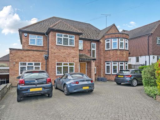 4 bedroom detached house for sale in Holmdene Avenue, Mill Hill, NW7 — £1,875,000 • 4 bed • 2 bath • 1827 ft²
 4 bedroom detached house for sale in The Reddings, London, NW7 — £999,950 • 4 bed • 2 bath • 1469 ft²
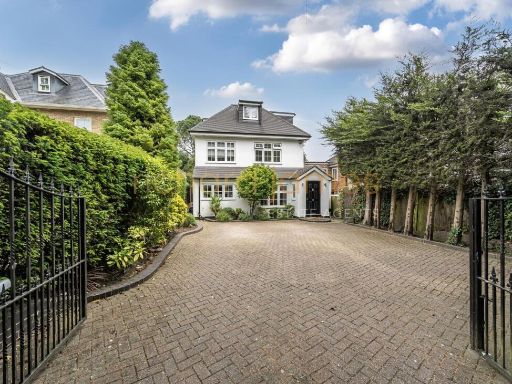 5 bedroom detached house for sale in Hendon Wood Lane, Mill Hill, NW7 — £1,995,000 • 5 bed • 3 bath • 2797 ft²
Meta
- {
"@context": "https://schema.org",
"@type": "Residence",
"name": "5 bedroom detached house for sale in The Reddings, Mill Hil…",
"description": "",
"url": "https://propertypiper.co.uk/property/3204ea51-4153-4513-a747-16b549b5255a",
"image": "https://image-a.propertypiper.co.uk/55dab9a0-a3da-4d2b-a2a0-533ac26c8047-1024.jpeg",
"address": {
"@type": "PostalAddress",
"streetAddress": "7 THE REDDINGS LONDON",
"postalCode": "NW7 4JN",
"addressLocality": "Barnet",
"addressRegion": "Hendon",
"addressCountry": "England"
},
"geo": {
"@type": "GeoCoordinates",
"latitude": 51.623164372798186,
"longitude": -0.24094968518810506
},
"numberOfRooms": 5,
"numberOfBathroomsTotal": 5,
"floorSize": {
"@type": "QuantitativeValue",
"value": 2881,
"unitCode": "FTK"
},
"offers": {
"@type": "Offer",
"price": 1595000,
"priceCurrency": "GBP",
"availability": "https://schema.org/InStock"
},
"additionalProperty": [
{
"@type": "PropertyValue",
"name": "Feature",
"value": "detached house"
},
{
"@type": "PropertyValue",
"name": "Feature",
"value": "brick exterior"
},
{
"@type": "PropertyValue",
"name": "Feature",
"value": "modern style"
},
{
"@type": "PropertyValue",
"name": "Feature",
"value": "double-story"
},
{
"@type": "PropertyValue",
"name": "Feature",
"value": "driveway"
},
{
"@type": "PropertyValue",
"name": "Feature",
"value": "residential area"
},
{
"@type": "PropertyValue",
"name": "Feature",
"value": "contemporary"
},
{
"@type": "PropertyValue",
"name": "Feature",
"value": "entryway"
},
{
"@type": "PropertyValue",
"name": "Feature",
"value": "modern"
},
{
"@type": "PropertyValue",
"name": "Feature",
"value": "bright"
},
{
"@type": "PropertyValue",
"name": "Feature",
"value": "neutral tones"
},
{
"@type": "PropertyValue",
"name": "Feature",
"value": "tiled flooring"
},
{
"@type": "PropertyValue",
"name": "Feature",
"value": "staircase"
},
{
"@type": "PropertyValue",
"name": "Feature",
"value": "open layout"
}
]
}
High Res Floorplan Images
Compatible Floorplan Images
FloorplanImages Thumbnail