SM2 6LJ - 2 bedroom apartment for sale in Victoria Court, 31 Mulgrave…
View on Property Piper
2 bedroom apartment for sale in Victoria Court, 31 Mulgrave Road, Sutton, SM2
Property Details
- Price: £400000
- Bedrooms: 2
- Bathrooms: 2
- Property Type: undefined
- Property SubType: undefined
Brochure Descriptions
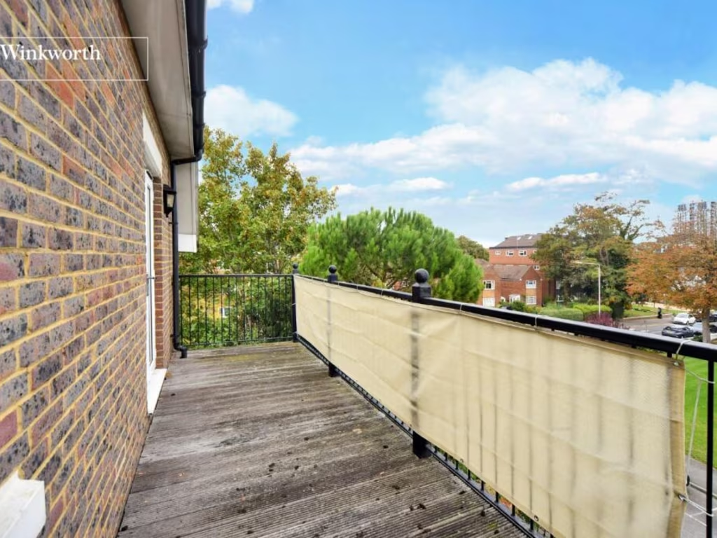
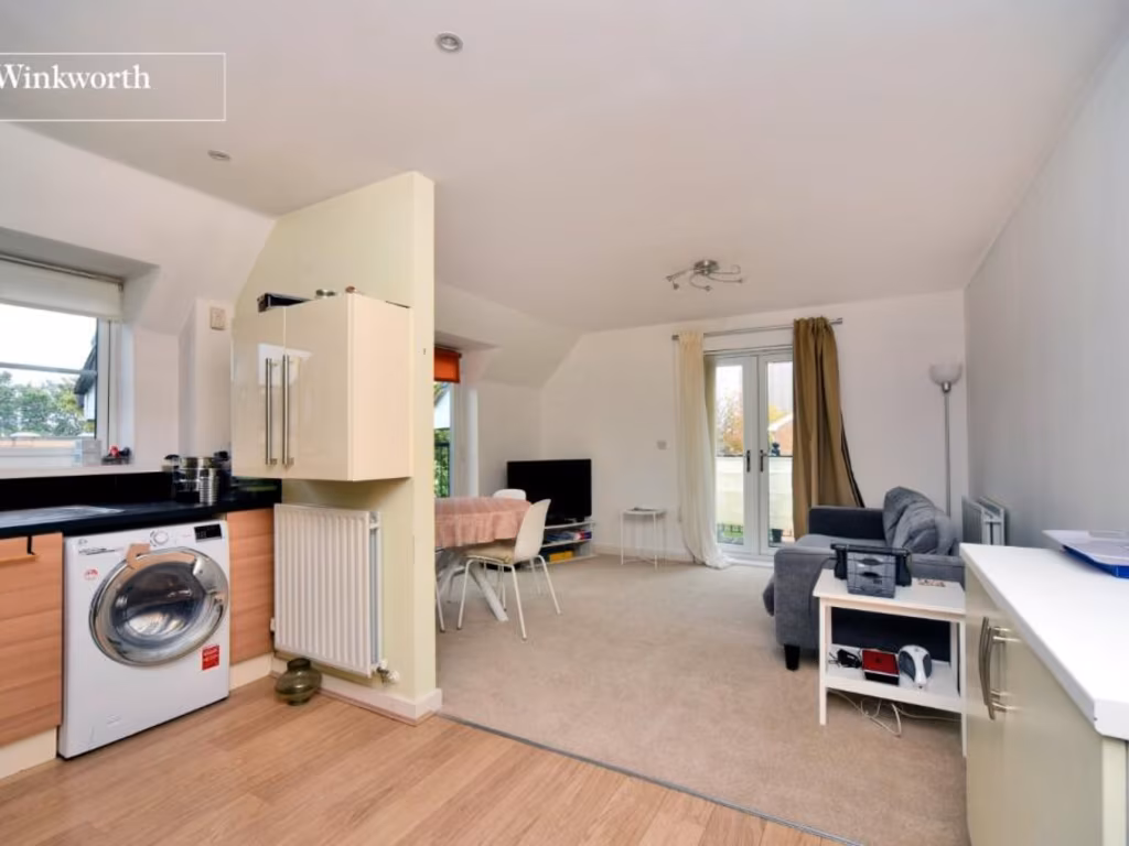
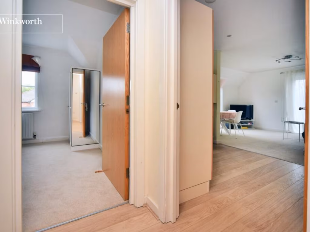
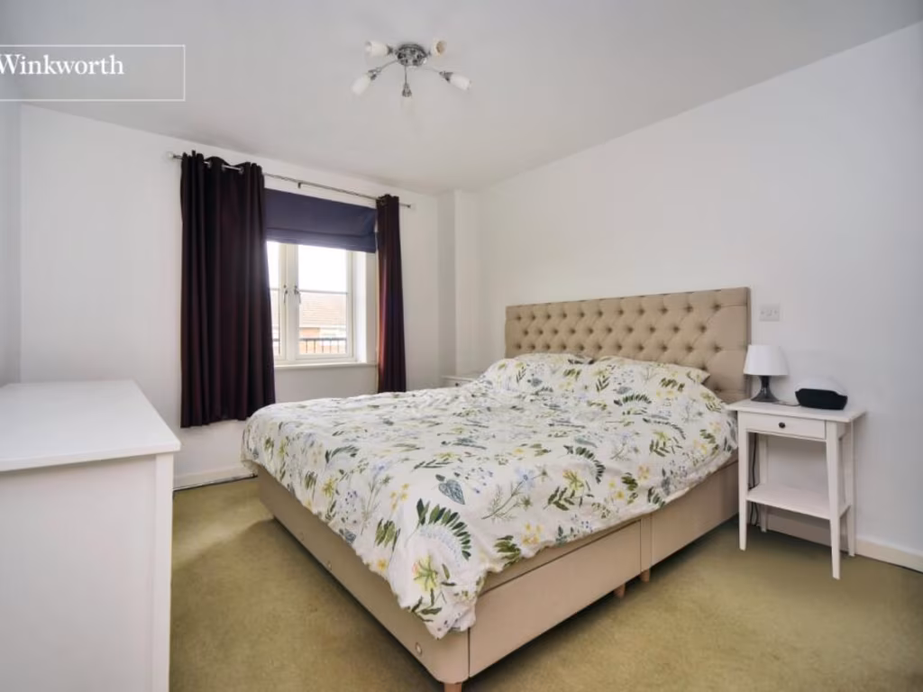
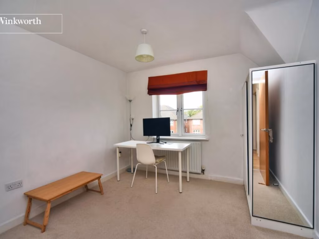
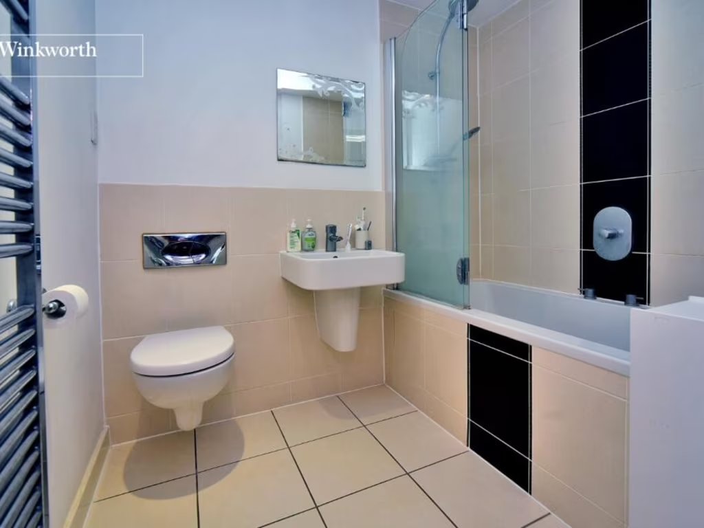
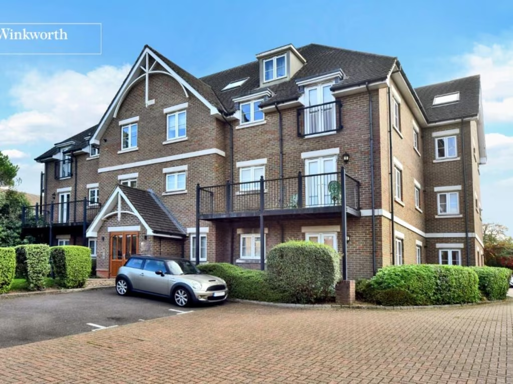
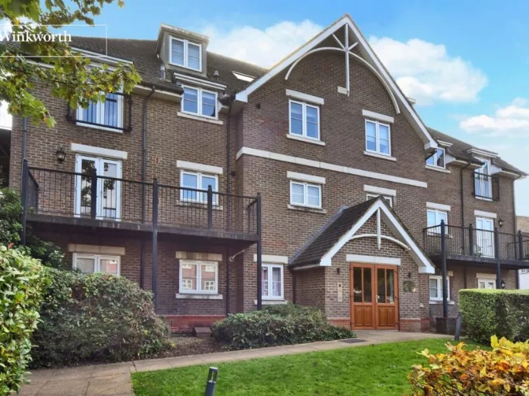
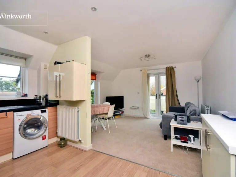
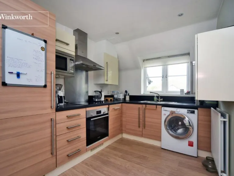
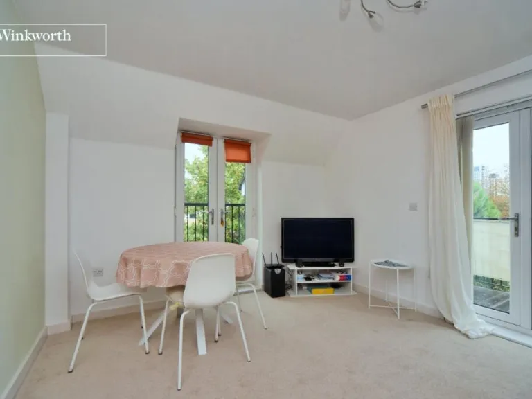
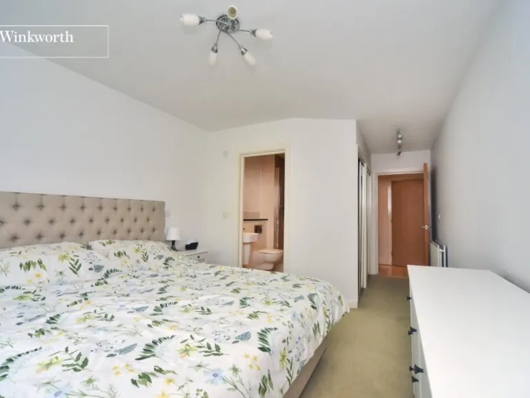
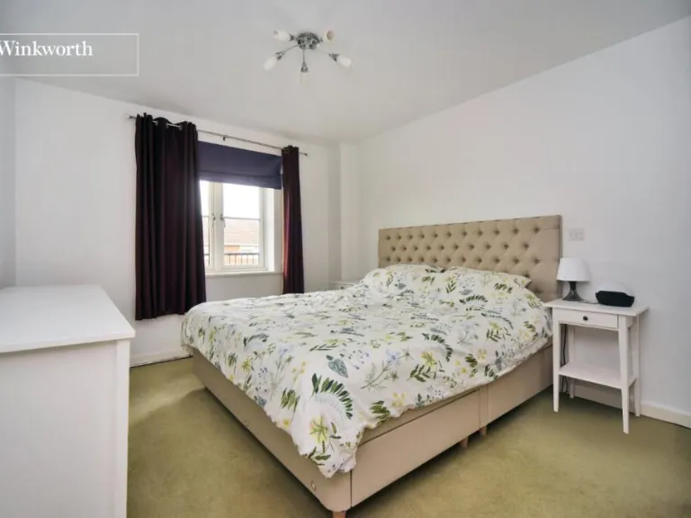
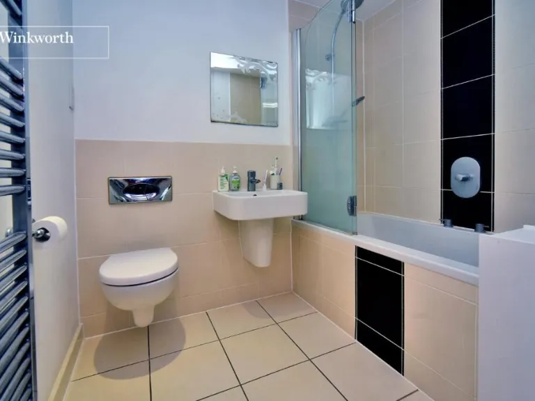
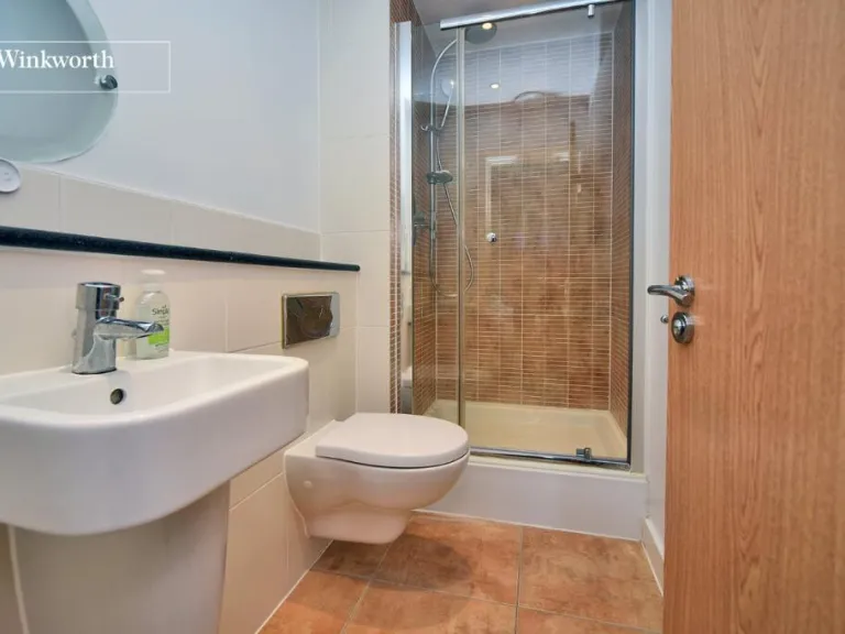
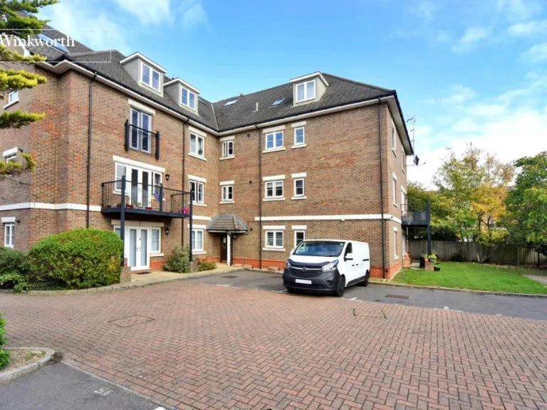
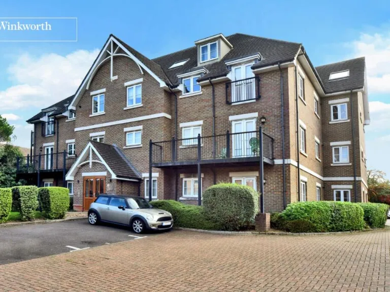
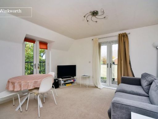
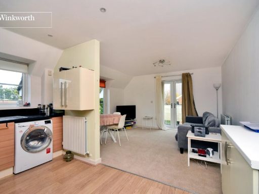
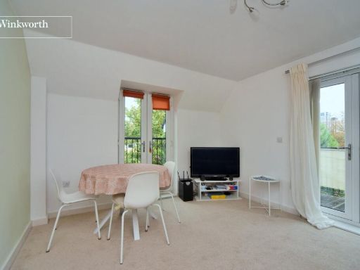
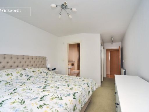
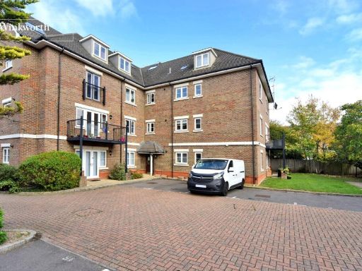
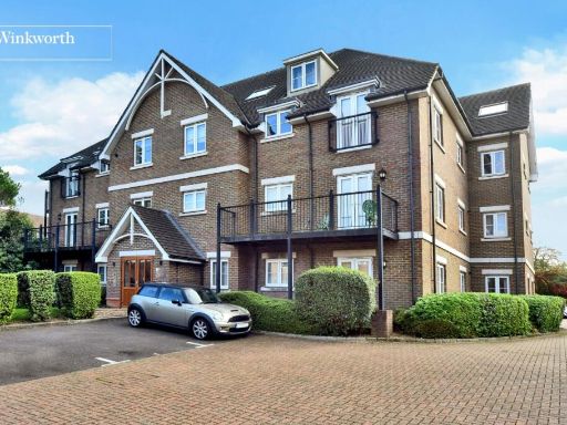
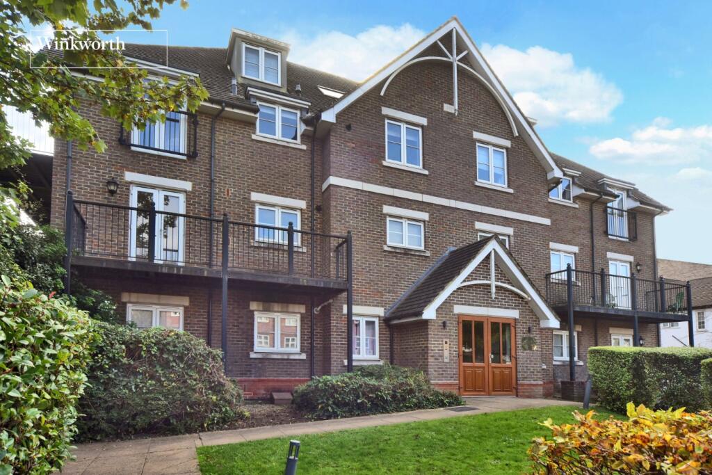
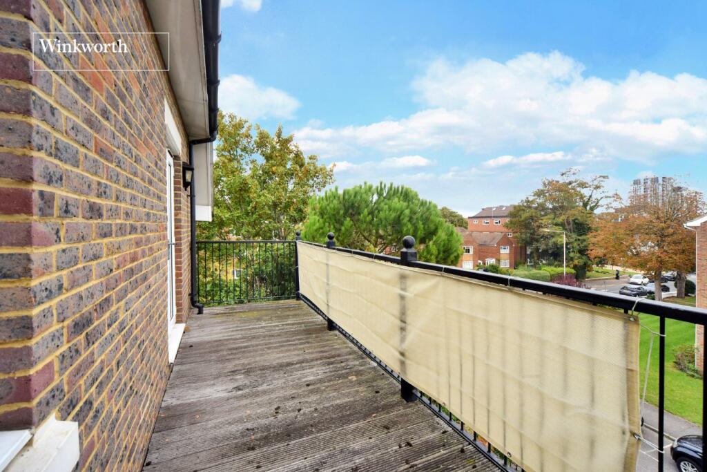
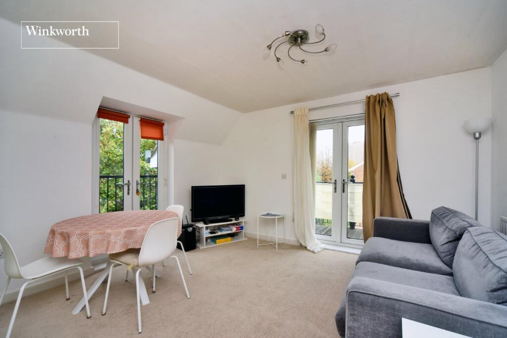
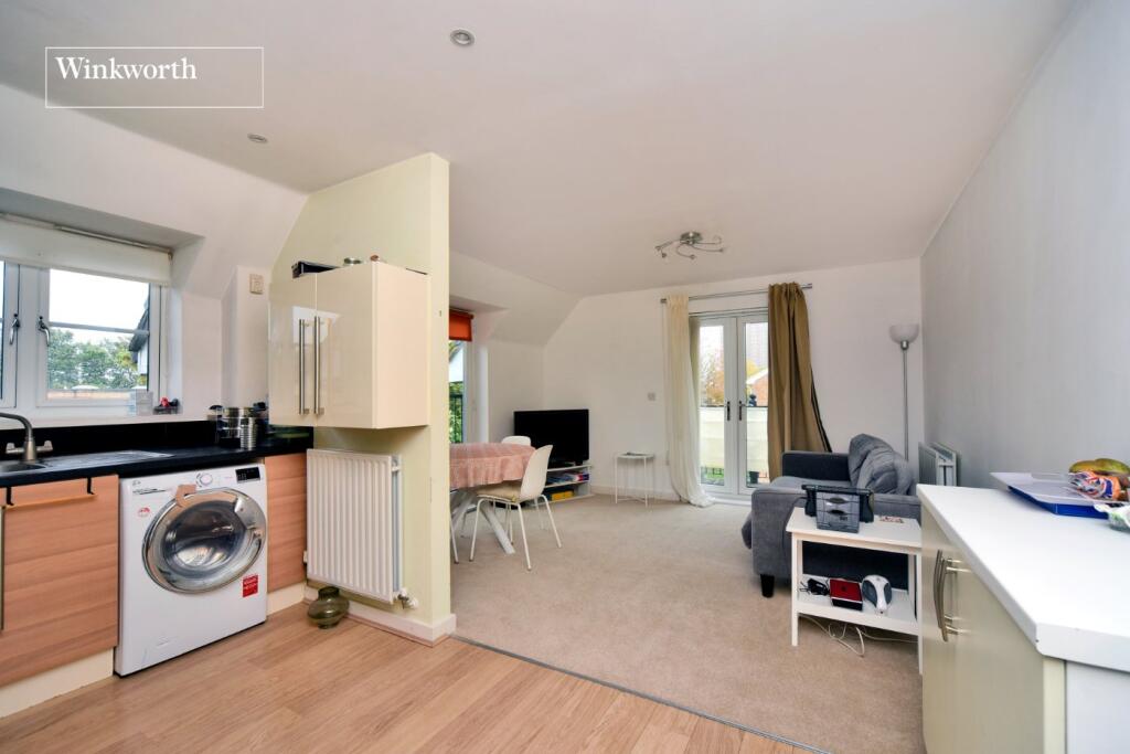
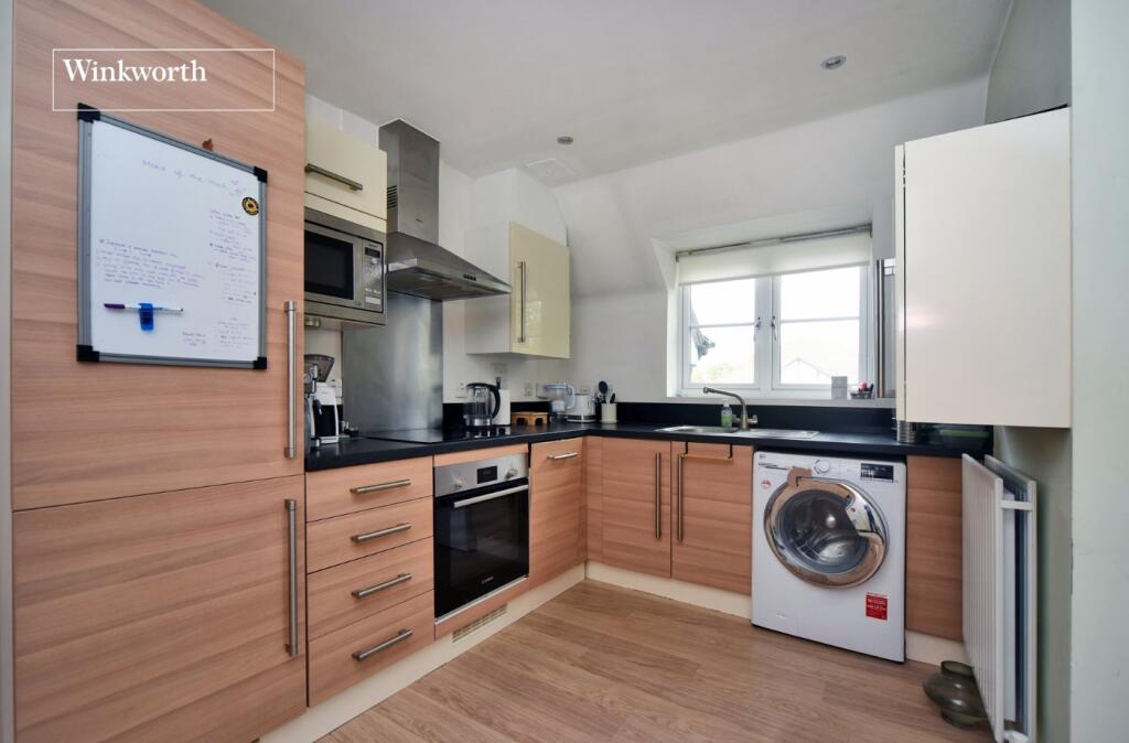
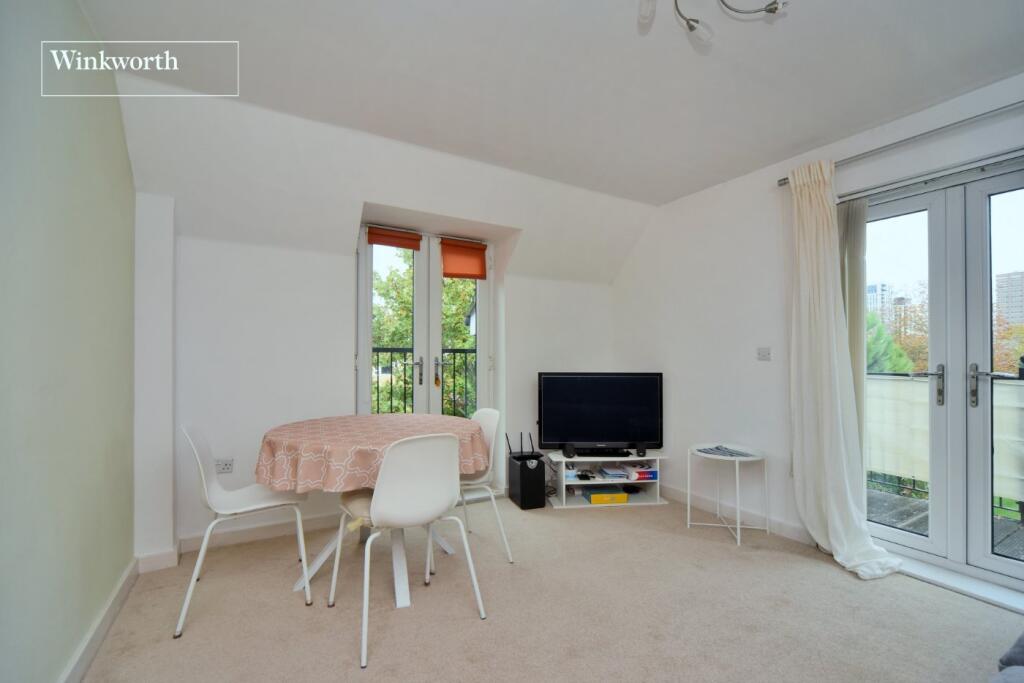
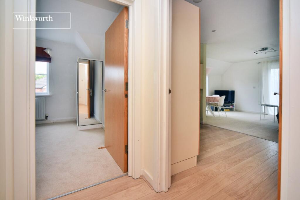
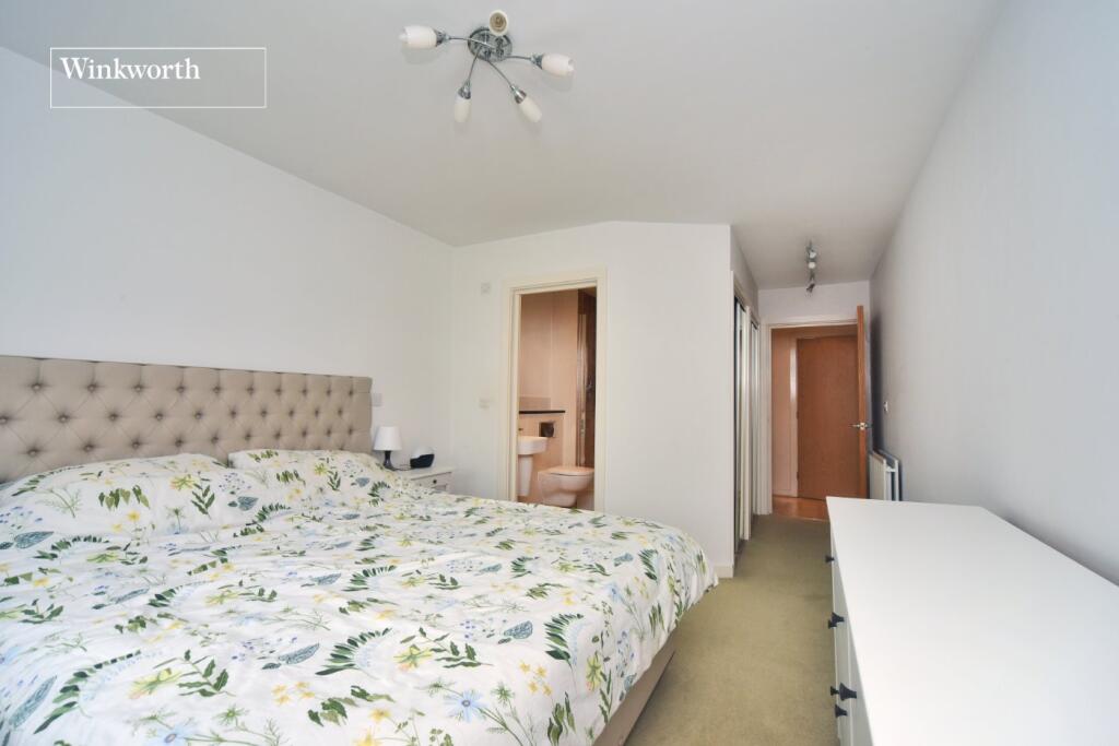
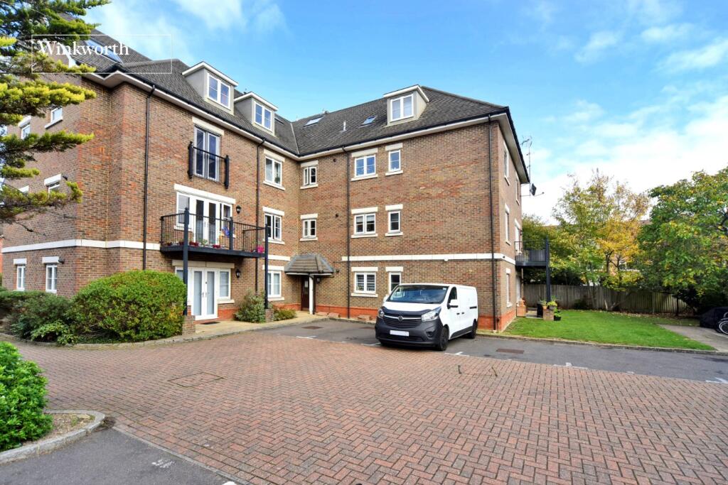
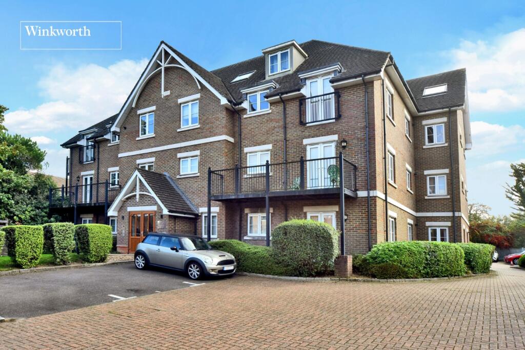
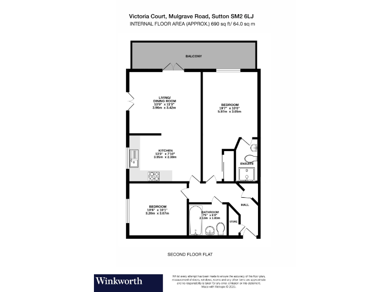
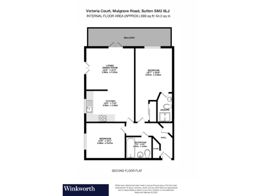
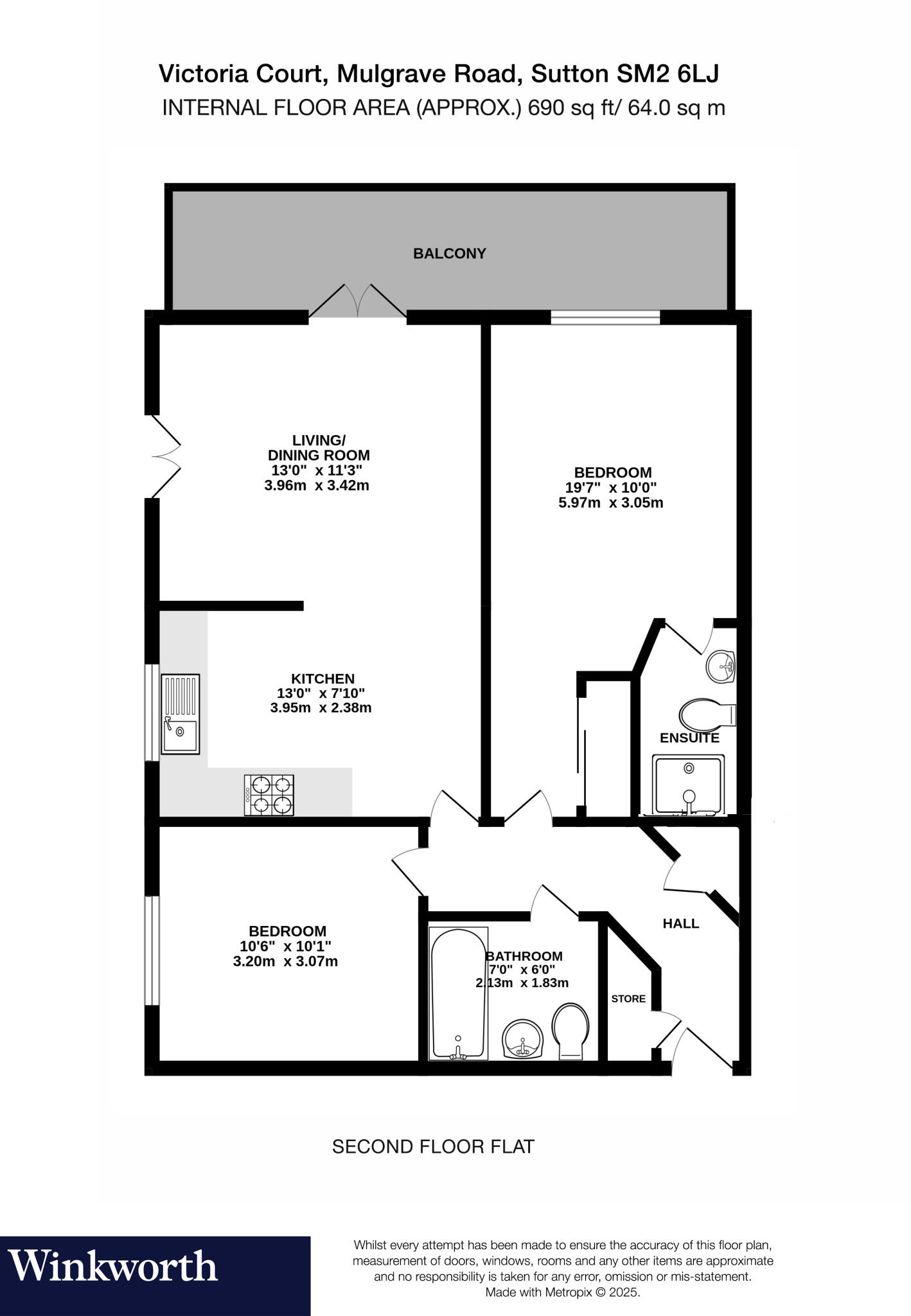
- Purpose-built contemporary apartment in a well‑maintained brick block with communal entrance and landscaped front gardens. The listing is for a two double‑bedroom, two‑bathroom apartment featuring an open‑plan kitchen/lounge/dining area with access to a small balcony, modern fitted kitchen space (including washer), and neutral decoration throughout. The building is set close to Sutton train station (convenient location). Room sizes appear average for a two‑bed flat; overall the apartment and block present as a medium‑sized residential property suitable for couples, professionals or buy‑to‑let investors.
Image Descriptions
- apartment building modern
- balcony modern
Rooms
- LIVING/ DINING ROOM:
- BEDROOM:
- KITCHEN:
- BEDROOM:
- BATHROOM:
- ENSUITE:
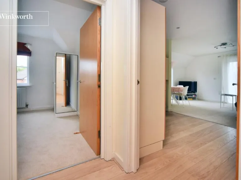
- HALL:
- STORE:
Textual Property Features
Detected Visual Features
- modern apartment
- brick exterior
- balcony
- three-story building
- pitched roof
- garage potential
- garden front
- modern
- metal railing
- outdoor space
EPC Details
- Fully double glazed
- Cavity wall, as built, insulated (assumed)
- Boiler and radiators, mains gas
- Low energy lighting in 80% of fixed outlets
- (another dwelling below)
Nearby Schools
- Banstead Preparatory School
- Seaton House School
- Avenue Primary Academy
- Overton Grange School
- Devonshire Primary School
- Homefield Preparatory School
- Cheam Fields Primary Academy
- Sutton Grammar School
- Westbourne Primary School
- Greenshaw High School
- Abbey Primary School
- Sutton High School GDST
- Rushy Meadow Primary Academy
- Cheam Park Farm Primary Academy
- Cuddington Croft Primary School
- Barrow Hedges Primary School
- Nonsuch High School for Girls
- St Dunstan's Cheam CofE Primary School
- Robin Hood Infants' School
- Manor Park Primary Academy
- Robin Hood Junior School
- Cheam High School
- All Saints Benhilton CofE Primary School
- Carshalton Boys Sports College
- Harris Academy Sutton
- St Philomena's Catholic High School for Girls
- Glenthorne High School
Nearest General Shops
- Id: 1674575890
- Tags:
- Name: Chamaral
- Shop: hairdresser
- TagsNormalized:
- Lat: 51.3584626
- Lon: -0.1914012
- FullGeoHash: gcpu5ts8sp2f
- PartitionGeoHash: gcpu
- Images:
- FoodStandards: null
- Distance: 280.4
,- Id: 1675499171
- Tags:
- Name: Angelo's
- Shop: hairdresser
- TagsNormalized:
- Lat: 51.359214
- Lon: -0.1919035
- FullGeoHash: gcpu5tsm076m
- PartitionGeoHash: gcpu
- Images:
- FoodStandards: null
- Distance: 276.2
,- Id: 1675499150
- Tags:
- Addr:
- City: Sutton
- Housenumber: 22
- Postcode: SM2 6LE
- Street: Mulgrave Road
- Name: W A Truelove & Son Ltd.
- Opening_hours: Mo-Fr 09:00-17:00
- Phone: +44 20 8642 0089
- Shop: funeral_directors
- Website: http://www.watltd.co.uk/branches/sutton-mulgrave-road/
- TagsNormalized:
- funeral
- funeral directors
- shop
- Lat: 51.3590223
- Lon: -0.1920524
- FullGeoHash: gcpu5ts5uzem
- PartitionGeoHash: gcpu
- Images:
- FoodStandards: null
- Distance: 257.1
}
Nearest Grocery shops
- Id: 1675538082
- Tags:
- Brand: Londis
- Brand:wikidata: Q21008564
- Brand:wikipedia: en:Londis (United Kingdom)
- Name: Londis
- Shop: convenience
- TagsNormalized:
- Lat: 51.3599426
- Lon: -0.191368
- FullGeoHash: gcpu5tu9kg1x
- PartitionGeoHash: gcpu
- Images:
- FoodStandards: null
- Distance: 352.2
,- Id: 1674576159
- Tags:
- Addr:
- Brand: M&S Simply Food
- Brand:wikidata: Q714491
- Contact:
- Website: https://www.marksandspencer.com/stores/sutton-rail-simply-food-1183
- Name: M&S Simply Food
- Opening_hours: Su 07:00-20:00, Mo-We 06:30-21:00, Th-Fr 06:30-22:00, Sa 07:00-22:00
- Payment:
- Android_pay: yes
- Cash: yes
- Contactless: yes
- Credit_cards: yes
- Shop: convenience
- TagsNormalized:
- m&s simply food
- food
- convenience
- shop
- Lat: 51.3597975
- Lon: -0.1912362
- FullGeoHash: gcpu5tu8xb5v
- PartitionGeoHash: gcpu
- Images:
- FoodStandards: null
- Distance: 350
,- Id: 1674575980
- Tags:
- Brand: Tesco Express
- Brand:wikidata: Q98456772
- Contact:
- Website: https://www.tesco.com/store-locator/sutton/14-17-regent-parade
- Name: Tesco Express
- Name:fa: تسکو اکسپرس
- Shop: convenience
- TagsNormalized:
- tesco
- tesco express
- convenience
- shop
- Lat: 51.3581842
- Lon: -0.1913523
- FullGeoHash: gcpu5tkxj5mq
- PartitionGeoHash: gcpu
- Images:
- FoodStandards: null
- Distance: 279.7
}
Nearest Religious buildings
- Id: 154990811
- Tags:
- Amenity: place_of_worship
- Denomination: quaker
- Name: Sutton Friends Meeting House
- Religion: christian
- Source: local_knowledge
- TagsNormalized:
- place of worship
- quaker
- quakers
- christian
- church
- Lat: 51.3580205
- Lon: -0.1893503
- FullGeoHash: gcpu5tqn5ufj
- PartitionGeoHash: gcpu
- Images:
- FoodStandards: null
- Distance: 417.9
,- Id: 8946509262
- Tags:
- Amenity: place_of_worship
- Name: London Shepard Church
- TagsNormalized:
- Lat: 51.3603114
- Lon: -0.1915671
- FullGeoHash: gcpu5tue2pvp
- PartitionGeoHash: gcpu
- Images:
- FoodStandards: null
- Distance: 368.8
,- Id: 97576809
- Tags:
- Amenity: place_of_worship
- Building: yes
- Name: Sutton Baptist Church
- Religion: christian
- Website: http://www.suttonbaptistchurch.org.uk/
- TagsNormalized:
- place of worship
- baptist
- church
- christian
- Lat: 51.3610496
- Lon: -0.1941809
- FullGeoHash: gcpu5tfxg384
- PartitionGeoHash: gcpu
- Images:
- FoodStandards: null
- Distance: 349.5
}
Nearest Medical buildings
- Id: 1675557755
- Tags:
- Amenity: pharmacy
- Name: Kamsons
- Website: https://www.kamsons.co.uk/section.php/52/1/sutton
- TagsNormalized:
- Lat: 51.3601516
- Lon: -0.1940774
- FullGeoHash: gcpu5tfdtdjq
- PartitionGeoHash: gcpu
- Images:
- FoodStandards: null
- Distance: 256
,- Id: 8913791777
- Tags:
- Amenity: clinic
- Healthcare: clinic
- Name: Sutton Dialysis Unit
- TagsNormalized:
- clinic
- health
- healthcare
- unit
- Lat: 51.3598688
- Lon: -0.1935032
- FullGeoHash: gcpu5tg0gj3x
- PartitionGeoHash: gcpu
- Images:
- FoodStandards: null
- Distance: 245.4
,- Id: 5941212043
- Tags:
- Addr:
- City: Sutton
- Housenumber: 48
- Postcode: SM2 6LX
- Street: Mulgrave Road
- Amenity: doctors
- Fax: +44 20 8643 6244
- Healthcare: doctor
- Healthcare:speciality: general
- Name: Mulgrave Road Surgery
- Opening_hours: Mo-Fr 08:00-20:00
- Operator: NHS
- Phone: +44 20 8407 3600
- Website: http://www.mulgraveroadsurgery.nhs.uk/
- Wheelchair: yes
- TagsNormalized:
- doctor
- doctors
- health
- healthcare
- general
- surgery
- Lat: 51.358341
- Lon: -0.1962853
- FullGeoHash: gcpu5t9040xj
- PartitionGeoHash: gcpu
- Images:
- FoodStandards: null
- Distance: 74.4
,- Id: 5943836375
- Tags:
- Amenity: dentist
- Email: info@mulgravedental.com
- Healthcare: dentist
- Name: Mulgrave Dental Centre
- Opening_hours: Mo 09:30-15:00, Tu-We 08:30-16:00, Fr 09:30-14:30, Sa 09:00-14:00
- Phone: +44 20 8395 8483
- Website: https://www.mulgravedental.com/
- TagsNormalized:
- dentist
- health
- healthcare
- dental
- Lat: 51.358278
- Lon: -0.1944977
- FullGeoHash: gcpu5t6reuuj
- PartitionGeoHash: gcpu
- Images:
- FoodStandards: null
- Distance: 68.2
}
Nearest Airports
- Id: 260720166
- Tags:
- Aerodrome: international
- Aeroway: aerodrome
- Alt_name: Gatwick Airport
- Ele: 62
- Iata: LGW
- Icao: EGKK
- Internet_access: wlan
- Internet_access:fee: no
- Internet_access:ssid: Gatwick FREE Wi-Fi
- Name: London Gatwick Airport
- Operator: Gatwick Airport Limited
- Ref: LGW
- Website: https://www.gatwickairport.com/
- Wikidata: Q8703
- Wikipedia: en:Gatwick Airport
- TagsNormalized:
- airport
- international airport
- Lat: 51.1540917
- Lon: -0.1883773
- FullGeoHash: gcpg58qf4mzd
- PartitionGeoHash: gcpg
- Images:
- FoodStandards: null
- Distance: 22678.2
,- Id: 121158889
- Tags:
- Aerodrome: continental
- Aeroway: aerodrome
- Fhrs:
- Authority: City of London Corporation
- Iata: LCY
- Icao: EGLC
- Name: London City Airport
- Operator: London City Airport Limited
- Ref: LCY
- Website: https://www.londoncityairport.com/
- Wikidata: Q8982
- Wikipedia: en:London City Airport
- TagsNormalized:
- airport
- continental airport
- Lat: 51.5042658
- Lon: 0.0539987
- FullGeoHash: u10j10p64702
- PartitionGeoHash: u10j
- Images:
- FoodStandards: null
- Distance: 23735.8
,- Id: 14001268
- Tags:
- Access: yes
- Aerodrome: international
- Aerodrome:type: public
- Aeroway: aerodrome
- Alt_name: London Heathrow
- Alt_name_2: London Heathrow Airport
- Ele: 25
- Iata: LHR
- Icao: EGLL
- Int_name: Heathrow Airport
- Name: London Heathrow Airport
- Note: area still approx
- Old_name: London Airport
- Operator: Heathrow Airport Limited
- Rank_aci:
- Ref: LHR
- Short_name: Heathrow
- Type: multipolygon
- Website: https://www.heathrow.com/
- Wikidata: Q8691
- Wikipedia: en:Heathrow Airport
- TagsNormalized:
- airport
- international airport
- Lat: 51.4677522
- Lon: -0.4547736
- FullGeoHash: gcpsv9kv7h2h
- PartitionGeoHash: gcps
- Images:
- FoodStandards: null
- Distance: 21739.4
}
Nearest Leisure Facilities
- Id: 188075847
- Tags:
- TagsNormalized:
- Lat: 51.3604004
- Lon: -0.1979378
- FullGeoHash: gcpu5mzu58wf
- PartitionGeoHash: gcpu
- Images:
- FoodStandards: null
- Distance: 321.5
,- Id: 6812450967
- Tags:
- Addr:
- City: Sutton
- Housenumber: 29
- Postcode: SM2 5AJ
- Street: Brighton Road
- Brand: Anytime Fitness
- Brand:wikidata: Q4778364
- Brand:wikipedia: en:Anytime Fitness
- Leisure: fitness_centre
- Name: Anytime Fitness
- Opening_hours: 24/7
- Website: https://www.anytimefitness.co.uk/gyms/uk-0260/london-greater-london-sm2-5aj/
- TagsNormalized:
- anytime fitness
- fitness
- fitness centre
- leisure
- Lat: 51.3582951
- Lon: -0.1908264
- FullGeoHash: gcpu5tmpc2je
- PartitionGeoHash: gcpu
- Images:
- FoodStandards: null
- Distance: 317.2
,- Id: 154987777
- Tags:
- TagsNormalized:
- Lat: 51.3570501
- Lon: -0.1912535
- FullGeoHash: gcpu5tk8x2p0
- PartitionGeoHash: gcpu
- Images:
- FoodStandards: null
- Distance: 304.5
,- Id: 188075845
- Tags:
- TagsNormalized:
- Lat: 51.3602374
- Lon: -0.1971803
- FullGeoHash: gcpu5tb7j65t
- PartitionGeoHash: gcpu
- Images:
- FoodStandards: null
- Distance: 279.3
,- Id: 188075844
- Tags:
- TagsNormalized:
- Lat: 51.3599743
- Lon: -0.1969853
- FullGeoHash: gcpu5tb99cjh
- PartitionGeoHash: gcpu
- Images:
- FoodStandards: null
- Distance: 247.1
}
Nearest Tourist attractions
- Id: 269236138
- Tags:
- Name: Little Holland House
- Tourism: attraction
- TagsNormalized:
- Lat: 51.3553025
- Lon: -0.1706494
- FullGeoHash: gcpuhhgwrd68
- PartitionGeoHash: gcpu
- Images:
- FoodStandards: null
- Distance: 1742.4
,- Id: 425669383
- Tags:
- Description: A historic tudor home with later additions from the Stuart, Georgian and Victorian periods.
- Flickr: https://www.flickr.com/photos/25829192@N03/3960636881/
- Name: Whitehall
- Tourism: museum
- Website: http://www.friendsofwhitehallcheam.co.uk
- Wikidata: Q7995973
- Wikipedia: en:Whitehall (Sutton)
- TagsNormalized:
- Lat: 51.3594267
- Lon: -0.2171332
- FullGeoHash: gcpu5j9yk7jc
- PartitionGeoHash: gcpu
- Images:
- FoodStandards: null
- Distance: 1519.6
,- Id: 8954569413
- Tags:
- Name: Room Space
- Operator: Room Space
- Tourism: apartment
- TagsNormalized:
- Lat: 51.3609553
- Lon: -0.187139
- FullGeoHash: gcpu5tzxr250
- PartitionGeoHash: gcpu
- Images:
- FoodStandards: null
- Distance: 659.5
}
Nearest Bus stations and stops
- Id: 4994912244
- Tags:
- Highway: bus_stop
- Local_ref: AB
- Name: Sutton Station
- Naptan:
- Public_transport: platform
- TagsNormalized:
- Lat: 51.3590865
- Lon: -0.1916688
- FullGeoHash: gcpu5tskmg9k
- PartitionGeoHash: gcpu
- Images:
- FoodStandards: null
- Distance: 284.1
,- Id: 469782378
- Tags:
- Bench: yes
- Highway: bus_stop
- Lit: yes
- Local_ref: S
- Name: Sutton / Grove Road
- Naptan:
- AtcoCode: 490013082S
- Bearing: W
- CommonName: Sutton Head Post Office
- Indicator: Stop S
- Street: GROVE ROAD
- Public_transport: platform
- Shelter: yes
- Tactile_paving: no
- TagsNormalized:
- Lat: 51.3599741
- Lon: -0.1935276
- FullGeoHash: gcpu5tg1d3p7
- PartitionGeoHash: gcpu
- Images:
- FoodStandards: null
- Distance: 254.5
,- Id: 469786092
- Tags:
- Highway: bus_stop
- Name: Hail & Ride Worcester Road
- Naptan:
- AtcoCode: 490014941S
- Bearing: S
- CommonName: Worcester Road (SUT)
- Verified: no
- Physically_present: no
- Public_transport: platform
- TagsNormalized:
- Lat: 51.3575242
- Lon: -0.1929897
- FullGeoHash: gcpu5t77r02m
- PartitionGeoHash: gcpu
- Images:
- FoodStandards: null
- Distance: 173.3
,- Id: 469786091
- Tags:
- Highway: bus_stop
- Name: Hail & Ride Worcester Road
- Naptan:
- AtcoCode: 490014941N
- Bearing: N
- CommonName: Worcester Road (SUT)
- Verified: no
- Physically_present: no
- Public_transport: platform
- TagsNormalized:
- Lat: 51.3575495
- Lon: -0.1931965
- FullGeoHash: gcpu5t776jn5
- PartitionGeoHash: gcpu
- Images:
- FoodStandards: null
- Distance: 158.8
,- Id: 469789044
- Tags:
- Highway: bus_stop
- Name: Hail & Ride Worcester Road / Mulgrave Road
- Naptan:
- AtcoCode: 490018765N
- Bearing: N
- CommonName: Mulgrave Road Worcester Road
- Indicator: Stop
- Verified: no
- Physically_present: no
- Public_transport: platform
- TagsNormalized:
- Lat: 51.3582919
- Lon: -0.1934491
- FullGeoHash: gcpu5t7psr9b
- PartitionGeoHash: gcpu
- Images:
- FoodStandards: null
- Distance: 137.3
}
Nearest Hotels
- Id: 8951954340
- Tags:
- Addr:
- City: Sutton
- Housenumber: 8
- Postcode: SM1 4FS
- Street: Sutton Court Road
- Air_conditioning: yes
- Bar: yes
- Brand: Ibis
- Brand:wikidata: Q920166
- Brand:wikipedia: en:Ibis (hotel)
- Email: hb5j1-re@accor.com
- Internet_access: wlan
- Internet_access:fee: no
- Name: ibis London Sutton Point
- Pets_allowed: no
- Phone: +44 2045 53 0610
- Rooms: 99
- Smoking: no
- Stars: 3
- Tourism: hotel
- Website: https://all.accor.com/hotel/B5J1/index.en.shtml
- Wheelchair: yes
- TagsNormalized:
- Lat: 51.3602854
- Lon: -0.190419
- FullGeoHash: gcpu5tv76gjk
- PartitionGeoHash: gcpu
- Images:
- FoodStandards: null
- Distance: 427.8
,- Id: 261633241
- Tags:
- Name: Holiday Inn
- Tourism: hotel
- TagsNormalized:
- Lat: 51.3617505
- Lon: -0.1966293
- FullGeoHash: gcpu5w0gfhnx
- PartitionGeoHash: gcpu
- Images:
- FoodStandards: null
- Distance: 426.7
,- Id: 8951954339
- Tags:
- Addr:
- City: Sutton
- Housenumber: 8
- Postcode: SM1 4FS
- Street: Sutton Court Road
- Brand: Adagio
- Name: Adagio London Sutton Point
- Rooms: 59
- Tourism: hotel
- TagsNormalized:
- Lat: 51.360243
- Lon: -0.1906562
- FullGeoHash: gcpu5tv5j7hr
- PartitionGeoHash: gcpu
- Images:
- FoodStandards: null
- Distance: 411.8
}
Tags
- modern apartment
- brick exterior
- balcony
- three-story building
- pitched roof
- garage potential
- garden front
- balcony
- modern
- brick exterior
- metal railing
- outdoor space
Local Market Stats
- Average Price/sqft: £495
- Avg Income: £59000
- Rental Yield: 4.5%
- Social Housing: 4%
- Planning Success Rate: 54%
AirBnB Data
- 1km average: £87/night
- Listings in 1km: 11
Similar Properties
 2 bedroom flat for sale in York Road, Cheam, Sutton, SM2 — £370,000 • 2 bed • 2 bath • 817 ft²
 2 bedroom flat for sale in Cheam Road, Sutton, SM1 2BE, SM1 — £380,000 • 2 bed • 2 bath • 784 ft²
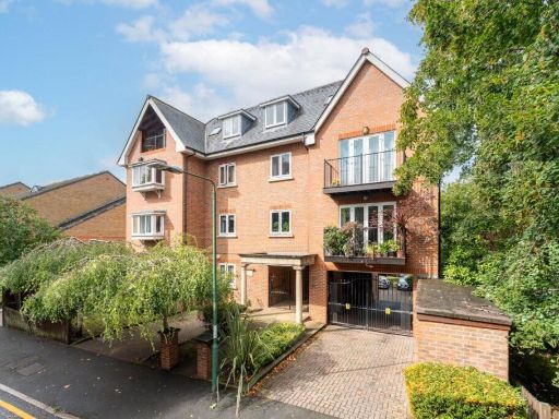 2 bedroom apartment for sale in Thicket Road, Sutton, SM1 — £409,950 • 2 bed • 2 bath • 969 ft²
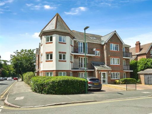 2 bedroom flat for sale in Worcester Road, Sutton, Surrey, SM2 — £360,000 • 2 bed • 2 bath • 863 ft²
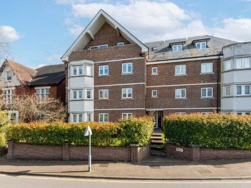 2 bedroom apartment for sale in Langley Park Road, Sutton, Surrey, SM2 — £375,000 • 2 bed • 1 bath • 766 ft²
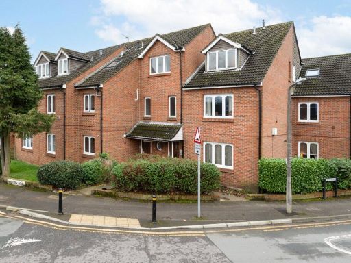 2 bedroom apartment for sale in Western Road, Sutton, Surrey, SM1 — £360,000 • 2 bed • 1 bath • 917 ft²
Meta
- {
"@context": "https://schema.org",
"@type": "Residence",
"name": "2 bedroom apartment for sale in Victoria Court, 31 Mulgrave…",
"description": "",
"url": "https://propertypiper.co.uk/property/fe3545e3-a7d4-4fe6-8a20-9d4584463420",
"image": "https://image-a.propertypiper.co.uk/5edc9a16-1880-4572-8f67-6928f4c3054a-1024.jpeg",
"address": {
"@type": "PostalAddress",
"streetAddress": "VICTORIA COURT, 31 FLAT 15 MULGRAVE ROAD SUTTON",
"postalCode": "SM2 6LJ",
"addressLocality": "Sutton",
"addressRegion": "Sutton and Cheam",
"addressCountry": "England"
},
"geo": {
"@type": "GeoCoordinates",
"latitude": 51.35799482835921,
"longitude": -0.19536883551588957
},
"numberOfRooms": 2,
"numberOfBathroomsTotal": 2,
"floorSize": {
"@type": "QuantitativeValue",
"value": 690,
"unitCode": "FTK"
},
"offers": {
"@type": "Offer",
"price": 400000,
"priceCurrency": "GBP",
"availability": "https://schema.org/InStock"
},
"additionalProperty": [
{
"@type": "PropertyValue",
"name": "Feature",
"value": "modern apartment"
},
{
"@type": "PropertyValue",
"name": "Feature",
"value": "brick exterior"
},
{
"@type": "PropertyValue",
"name": "Feature",
"value": "balcony"
},
{
"@type": "PropertyValue",
"name": "Feature",
"value": "three-story building"
},
{
"@type": "PropertyValue",
"name": "Feature",
"value": "pitched roof"
},
{
"@type": "PropertyValue",
"name": "Feature",
"value": "garage potential"
},
{
"@type": "PropertyValue",
"name": "Feature",
"value": "garden front"
},
{
"@type": "PropertyValue",
"name": "Feature",
"value": "balcony"
},
{
"@type": "PropertyValue",
"name": "Feature",
"value": "modern"
},
{
"@type": "PropertyValue",
"name": "Feature",
"value": "brick exterior"
},
{
"@type": "PropertyValue",
"name": "Feature",
"value": "metal railing"
},
{
"@type": "PropertyValue",
"name": "Feature",
"value": "outdoor space"
}
]
}
High Res Floorplan Images
Compatible Floorplan Images
FloorplanImages Thumbnail