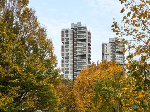
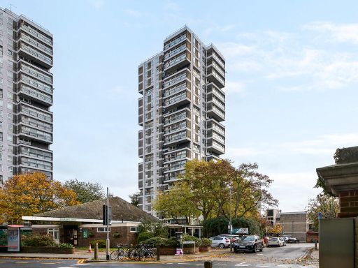
SW11 3NQ - 2 bedroom apartment for sale in Battersea Church Road, Wand…
View on Property Piper
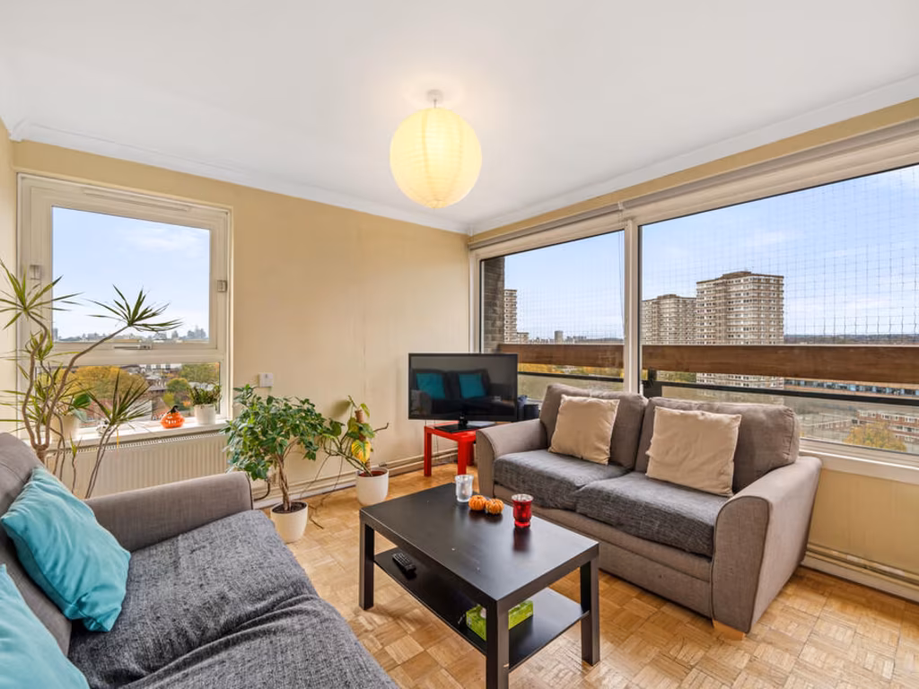
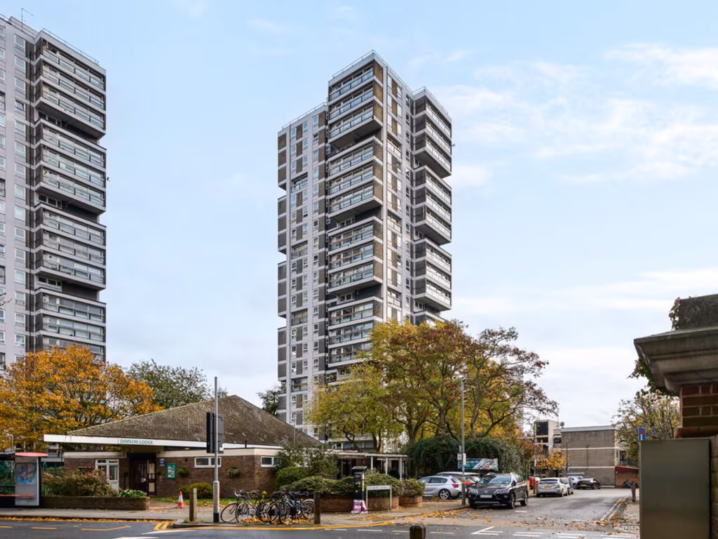
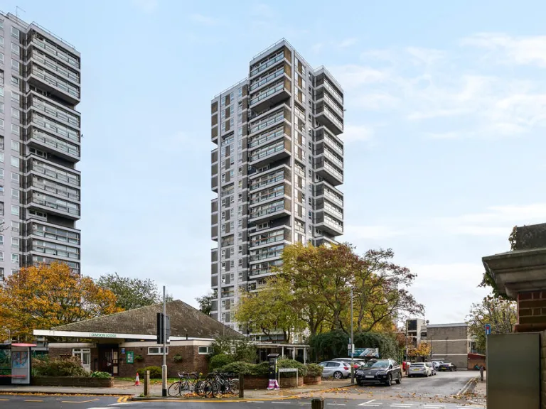
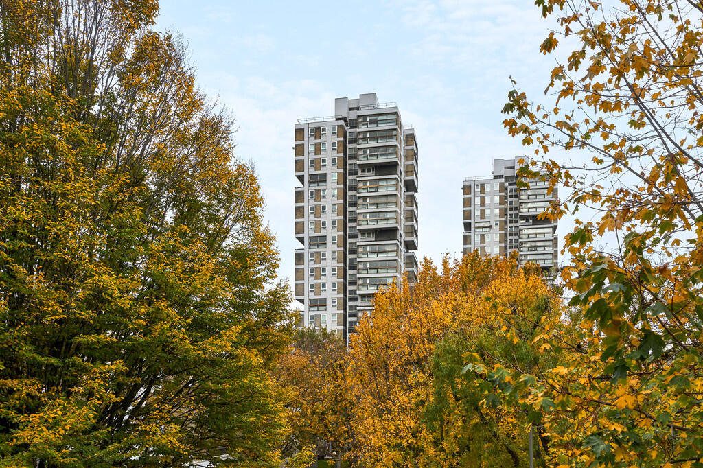
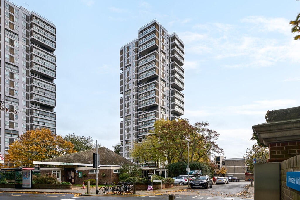
2 bedroom apartment for sale in Battersea Church Road, Wandsworth, SW11
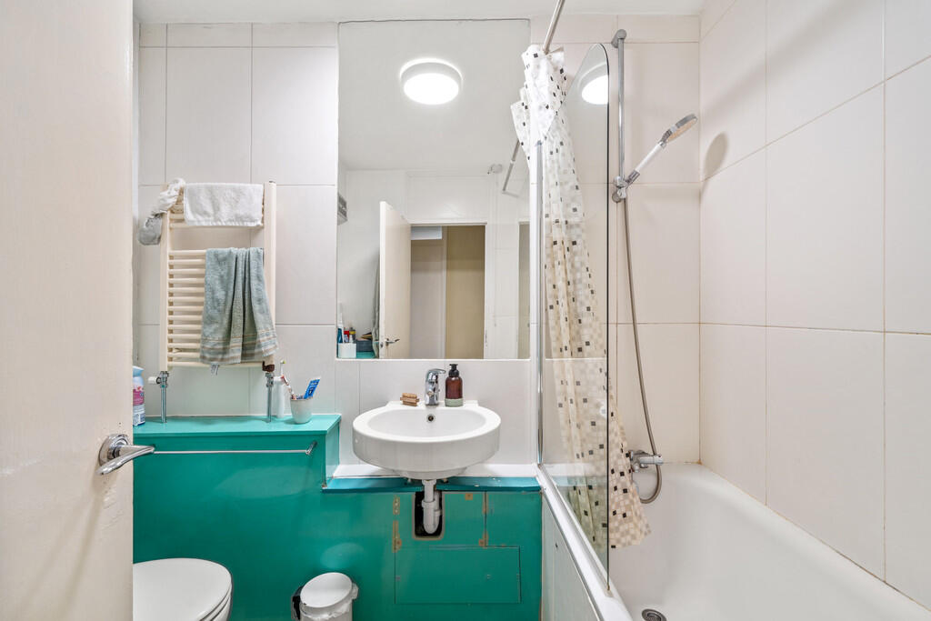
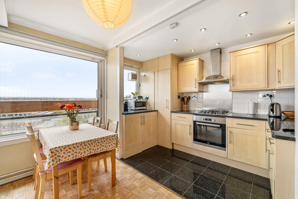
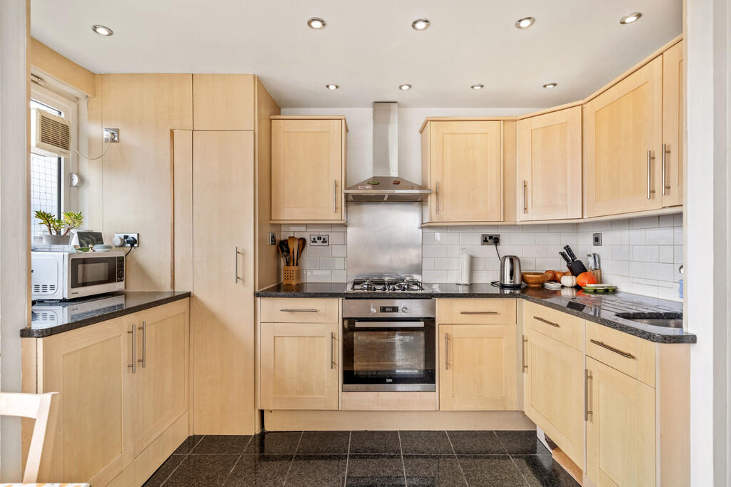
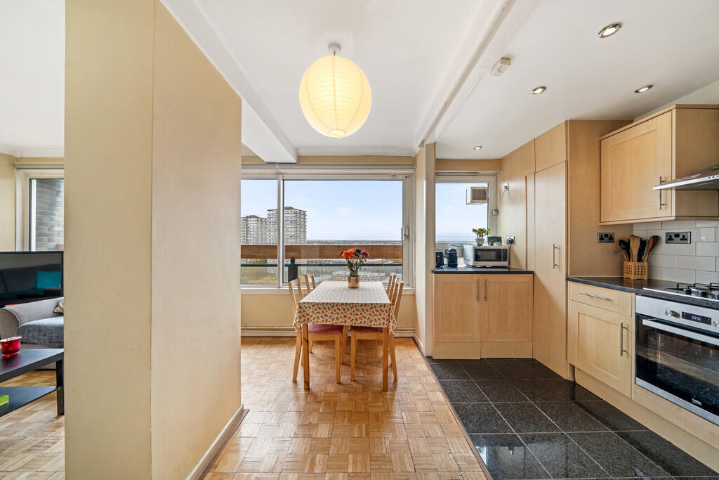
Property Details
- Price: £375000
- Bedrooms: 2
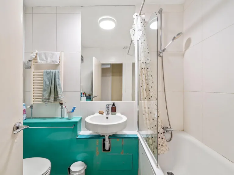
- Bathrooms: 1
- Property Type: undefined
- Property SubType: undefined
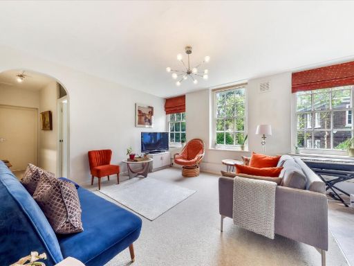
Image Descriptions
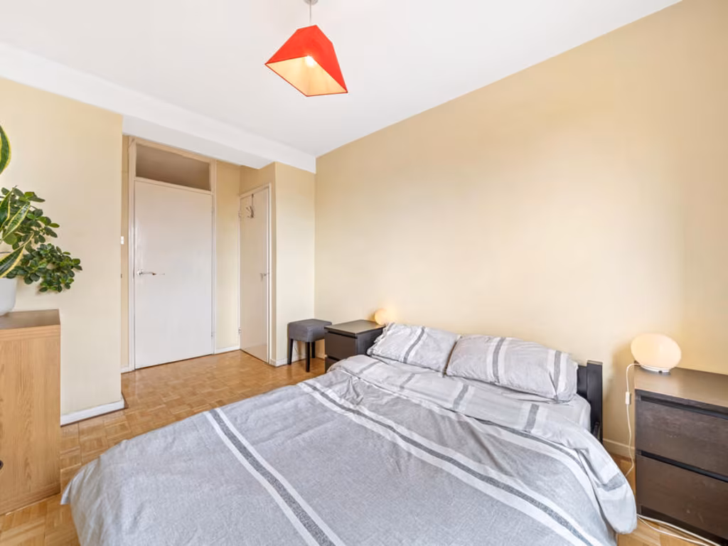
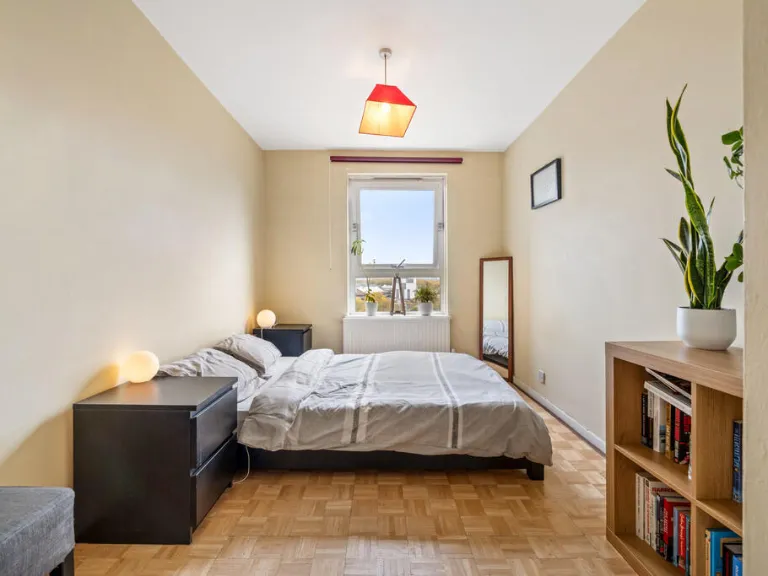
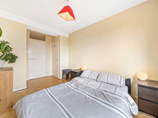
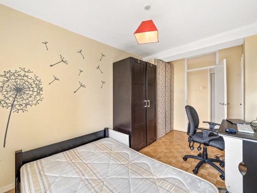
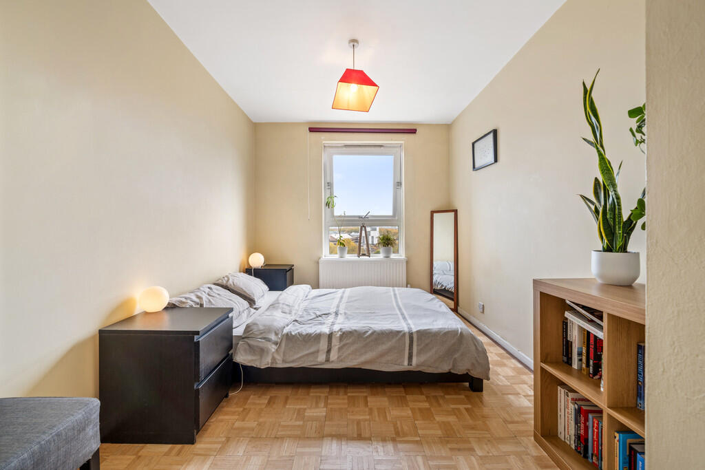
- bedroom contemporary
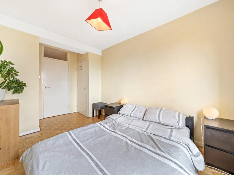
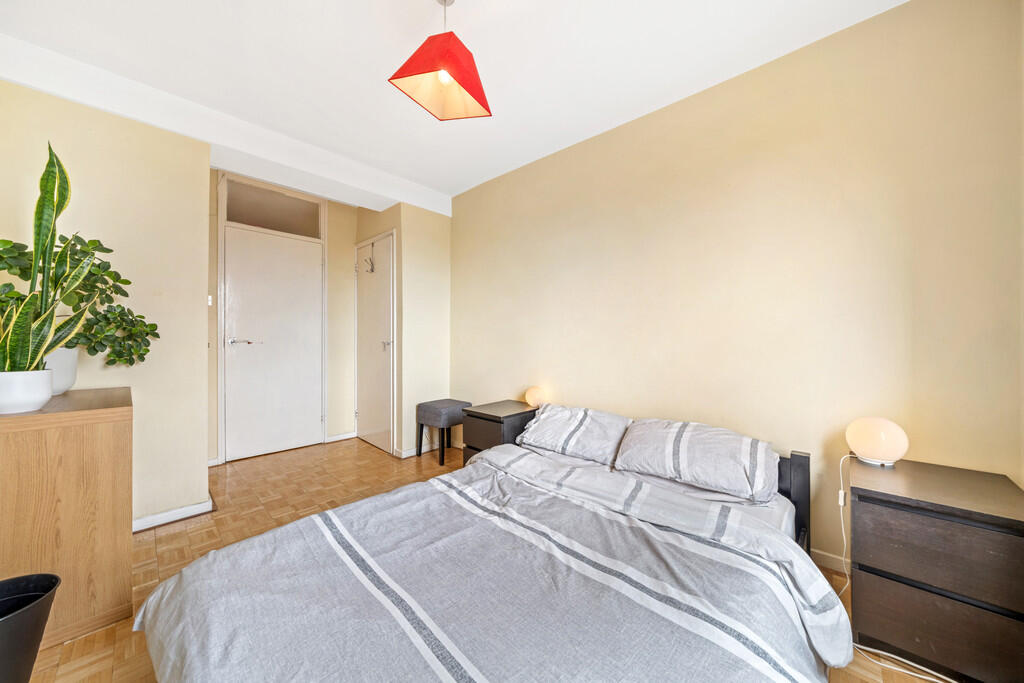
- bedroom mid-century modern
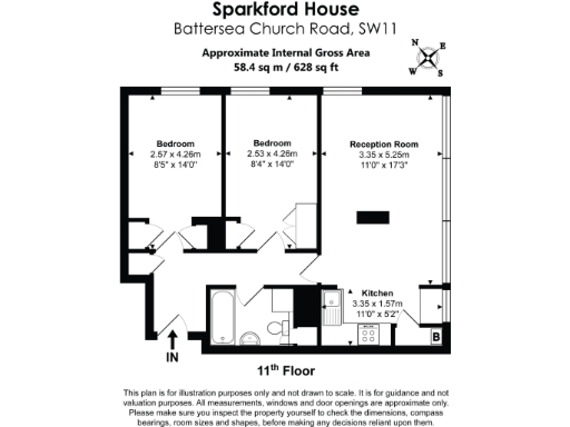
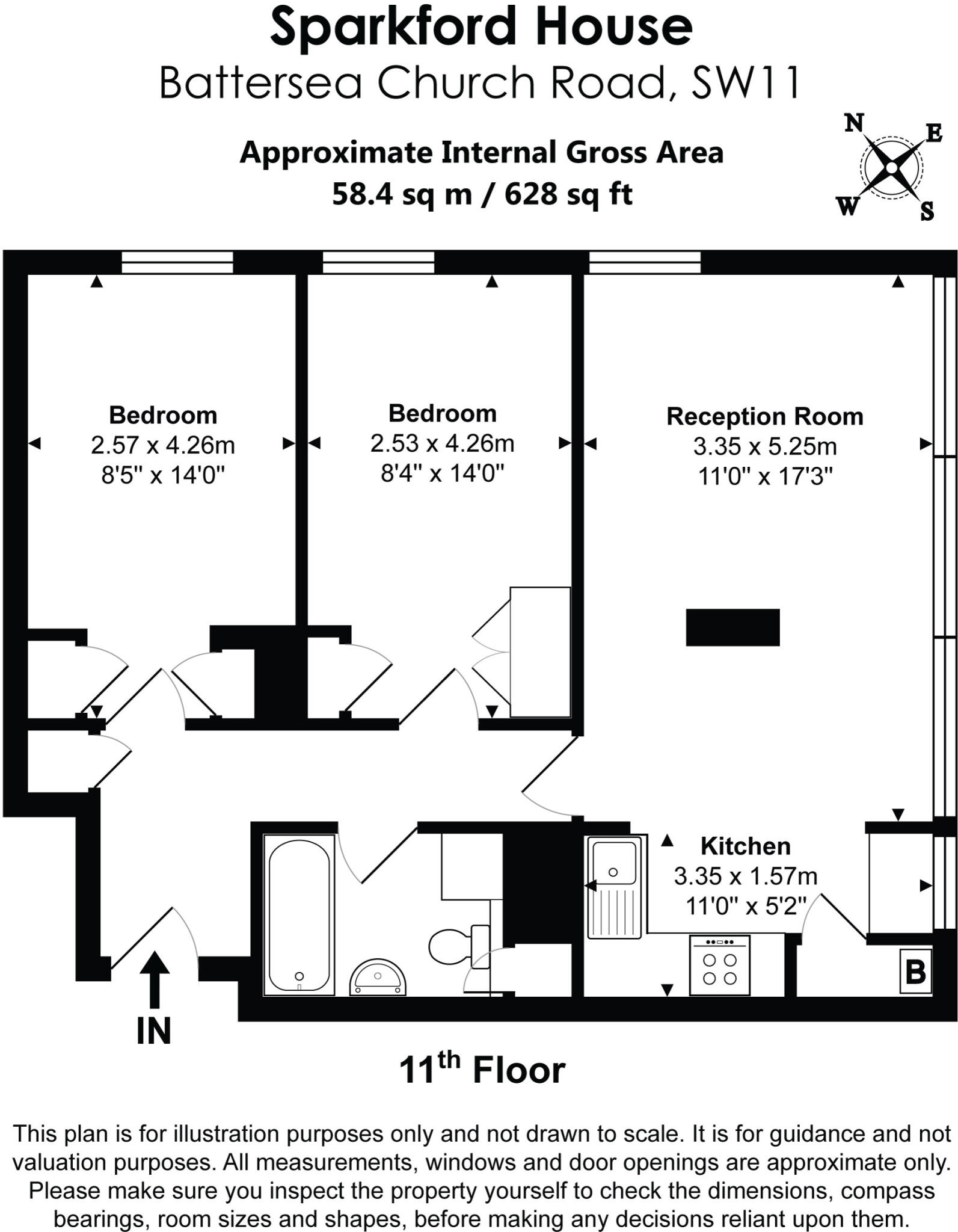
Rooms
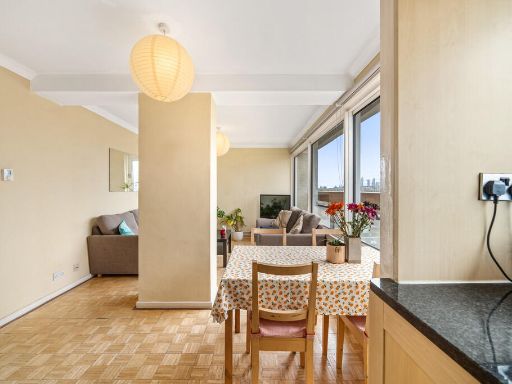
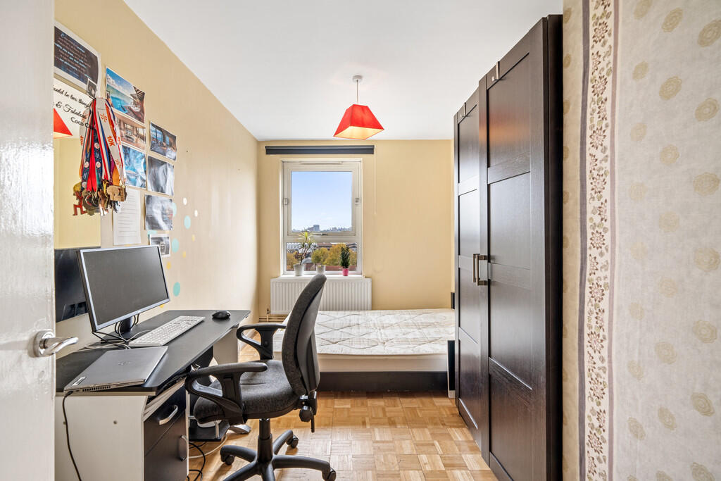
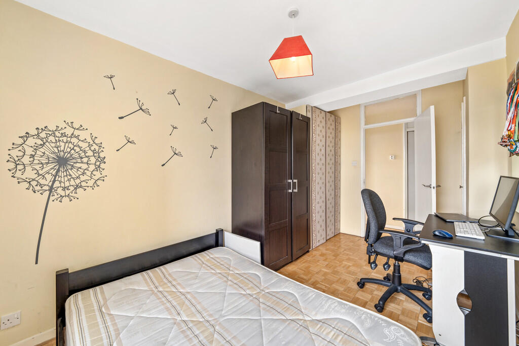
- Bedroom:
- Bedroom:
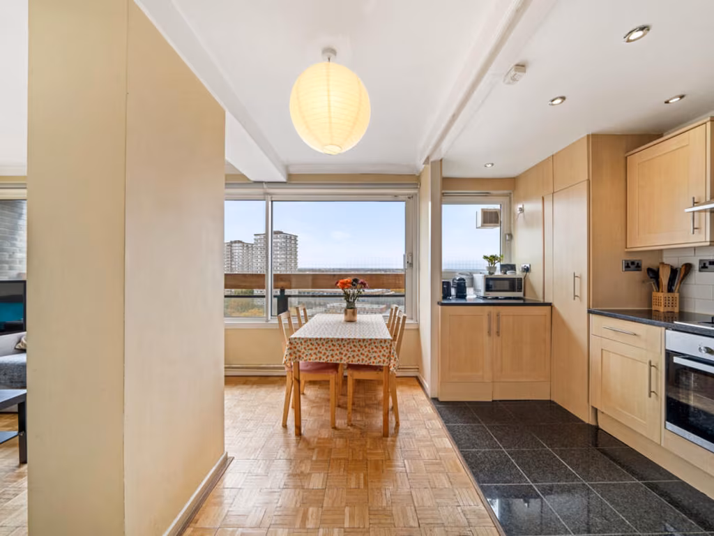
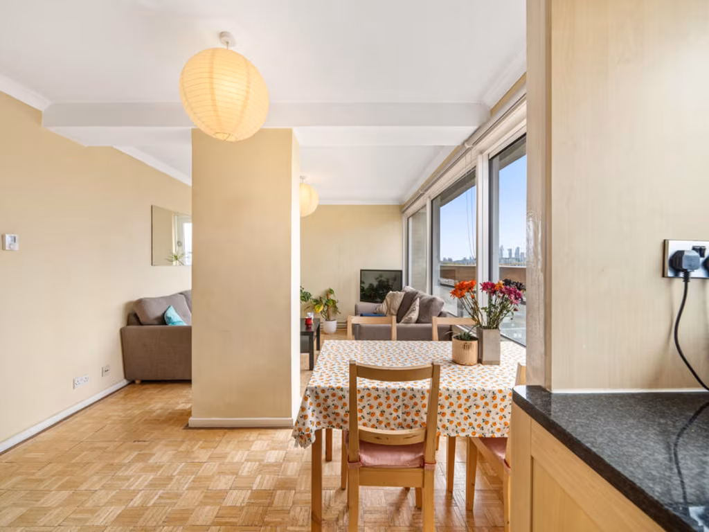
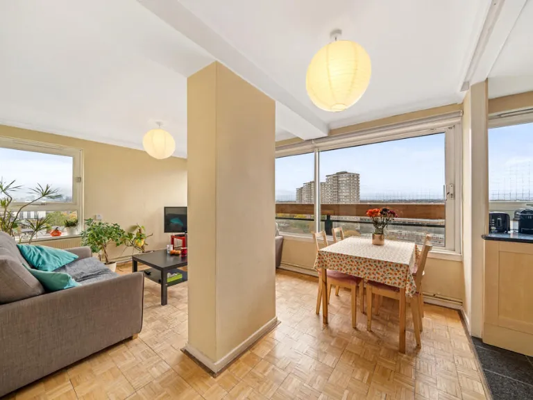
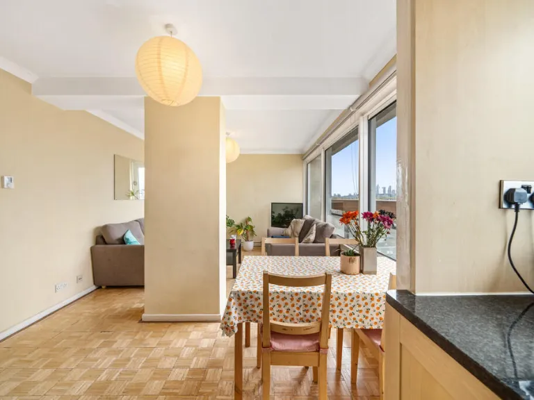
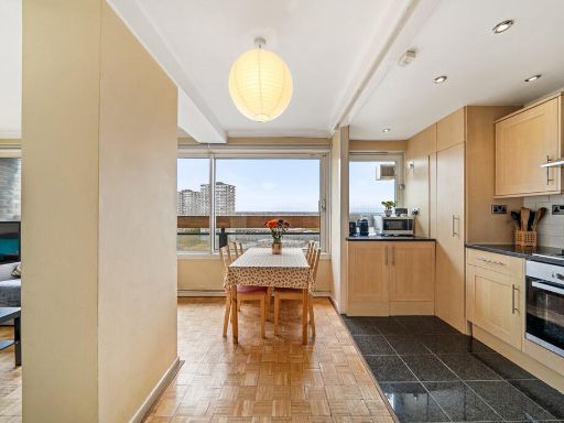
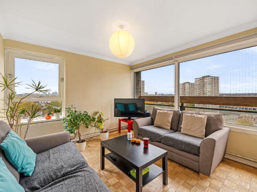
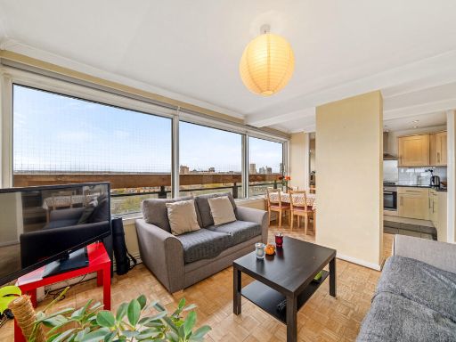
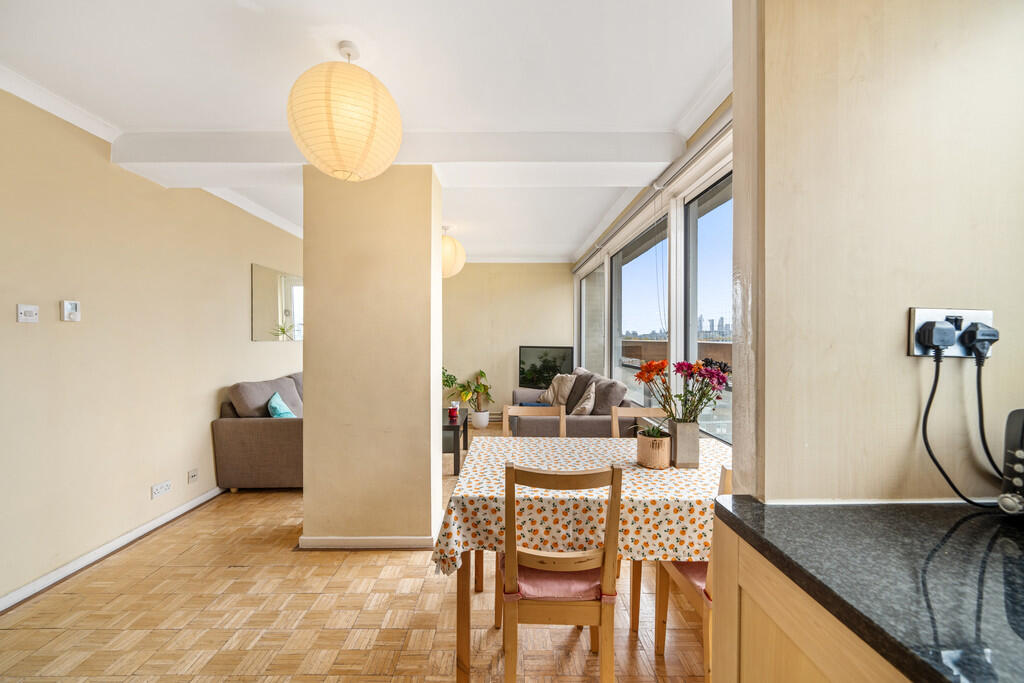
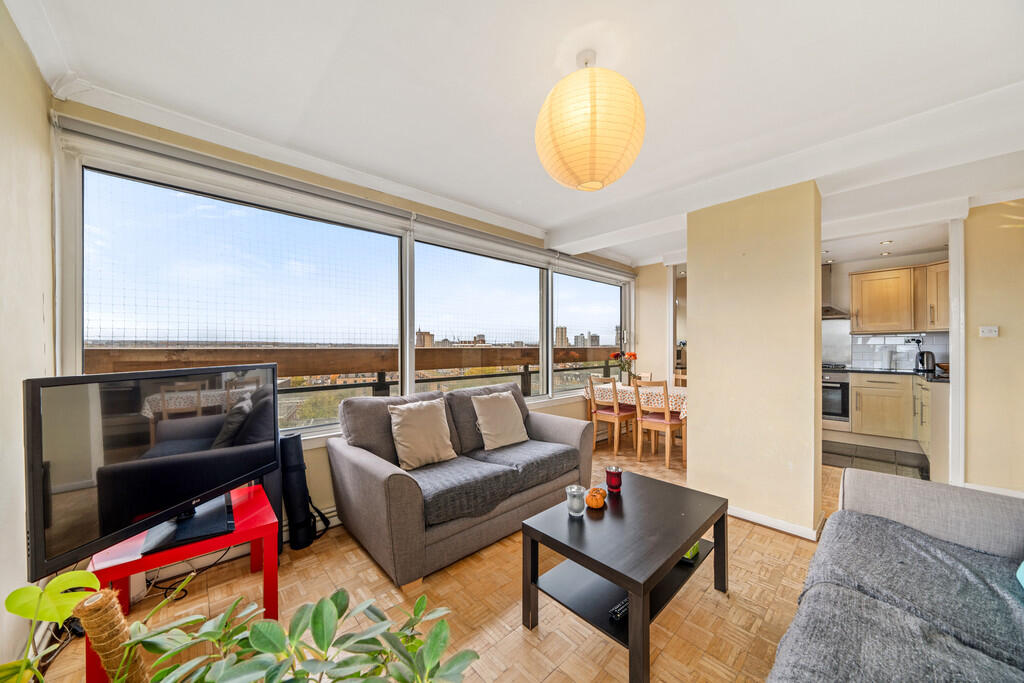
- Reception Room:
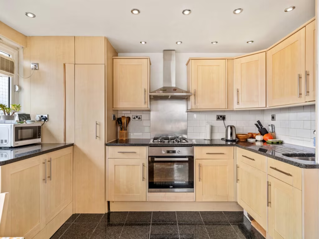
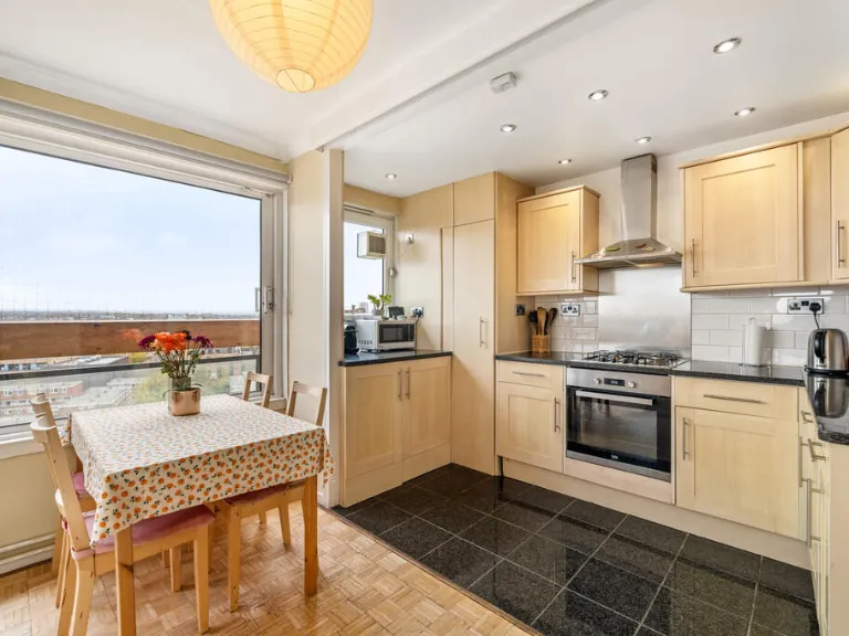
- Kitchen:
Textual Property Features
Detected Visual Features
- contemporary
- small bedroom
- parquet flooring
- standard ceiling
- natural light
- minimalist
- modern design
- bedroom
- mid-century modern
- wall-mounted light
- small room
- modernization needed
EPC Details
- Fully double glazed
- System built, with internal insulation
- Boiler and radiators, mains gas
- Low energy lighting in 67% of fixed outlets
- (another dwelling below)
Nearby Schools
- Park Walk Primary School
- Thames Christian School
- Falconbrook Primary School
- Langford Primary School
- L'Ecole de Battersea
- Ashburnham Community School
- Falkner House
- St Philip's School
- Our Lady of Victories RC Primary School
- Glendower Preparatory School
- ARK John Archer Primary Academy
- Sacred Heart Catholic Primary School, Battersea
- Harris Academy Battersea
- Westbridge Academy
- Servite RC Primary School
- Christ Church CofE Primary School
- Cameron Vale School
- Mander Portman Woodward School
- L'Ecole des Petits School
- Chesterton Primary School
- Thomas's Battersea
- Saint John Bosco College
- Chelsea Academy
- The Hampshire School Chelsea
- Bousfield Primary School
- Oratory Roman Catholic Primary School
- Marlborough Primary School
Nearest Bars And Restaurants
- Id: 340292095
- Tags:
- Addr:
- Housenumber: 11-12
- Postcode: SW11 3RA
- Street: Battersea Square
- Amenity: restaurant
- Building: yes
- Cuisine: lebanese
- Fhrs:
- Name: Mazar
- Opening_hours: Mo-Sa 08:30-23:30; Su 09:00-22:30
- Phone: +44 20 7978 5374
- Website: https://mazarrestaurant.com/
- TagsNormalized:
- Lat: 51.4751448
- Lon: -0.1747982
- FullGeoHash: gcpuu4b8qymp
- PartitionGeoHash: gcpu
- Images:
- FoodStandards: null
- Distance: 160.6
,- Id: 583286333
- Tags:
- Addr:
- Housenumber: 140
- Postcode: SW11 3PF
- Street: Westbridge Road
- Amenity: restaurant
- Cuisine: italian
- Fhrs:
- Name: Melanzana
- Opening_hours: Mo-Th 8:30-23:00;Fr-Sa 8:30-23:30;Su 10:00-22:00
- Phone: +44 20 7228 5420
- Takeaway: yes
- Website: https://www.melanzana.co.uk/
- TagsNormalized:
- restaurant
- italian
- takeaway
- Lat: 51.475325
- Lon: -0.174909
- FullGeoHash: gcpuu4b9s246
- PartitionGeoHash: gcpu
- Images:
- FoodStandards: null
- Distance: 146.3
,- Id: 13028898
- Tags:
- Addr:
- Housenumber: 140
- Postcode: SW11 3PF
- Street: Westbridge Road
- Amenity: restaurant
- Building: yes
- Cuisine: italian
- Name: Melanzana
- Type: multipolygon
- Website: https://www.melanzana.co.uk/
- Wikidata: Q26587126
- TagsNormalized:
- Lat: 51.475357
- Lon: -0.1749073
- FullGeoHash: gcpuu4b9sq59
- PartitionGeoHash: gcpu
- Images:
- FoodStandards: null
- Distance: 143.1
,- Id: 8957771541
- Tags:
- TagsNormalized:
- Lat: 51.4765876
- Lon: -0.1758148
- FullGeoHash: gcpuggpbz5qv
- PartitionGeoHash: gcpu
- Images:
- FoodStandards: null
- Distance: 136.9
,- Id: 162477134
- Tags:
- Addr:
- Housenumber: 96
- Postcode: SW11 3PH
- Street: Westbridge Road
- Amenity: pub
- Building: yes
- Fhrs:
- Height: 7
- Name: The Stag Bar
- Source:
- TagsNormalized:
- Lat: 51.4758626
- Lon: -0.1730747
- FullGeoHash: gcpuu4cuxh61
- PartitionGeoHash: gcpu
- Images:
- FoodStandards: null
- Distance: 85.6
}
Nearest General Shops
- Id: 340291846
- Tags:
- Addr:
- Housenumber: 10
- Postcode: SW11 3RA
- Street: Battersea Square
- Building: yes
- Name: Clothe Kare
- Shop: dry_cleaning
- TagsNormalized:
- Lat: 51.4752179
- Lon: -0.1748452
- FullGeoHash: gcpuu4b8vu1g
- PartitionGeoHash: gcpu
- Images:
- FoodStandards: null
- Distance: 154.7
,- Id: 3430574848
- Tags:
- Name: Square Gallery
- Shop: art
- TagsNormalized:
- Lat: 51.4753926
- Lon: -0.1752202
- FullGeoHash: gcpuu4b3vhdm
- PartitionGeoHash: gcpu
- Images:
- FoodStandards: null
- Distance: 152.2
,- Id: 3470342553
- Tags:
- Addr:
- Housenumber: 140
- Postcode: SW11 3PF
- Street: Westbridge Road
- Fhrs:
- Name: Melanzana
- Shop: deli
- Source:
- Website: https://www.melanzana.co.uk/a/deli/
- TagsNormalized:
- Lat: 51.47532
- Lon: -0.1749439
- FullGeoHash: gcpuu4b97x0k
- PartitionGeoHash: gcpu
- Images:
- FoodStandards: null
- Distance: 148
}
Nearest Grocery shops
- Id: 2238113479
- Tags:
- Addr:
- City: London
- Country: GB
- Housenumber: 27-37
- Postcode: SW11 3BA
- Street: Battersea Bridge Road
- Contact:
- Fhrs:
- Name: The Co-operative Food
- Opening_hours: 07:00-22:00
- Operator: Co-operative Group Ltd
- Shop: supermarket
- Website: https://www.co-operative.coop/store/food/SW11-3BA/27-37-battersea-bridge-road
- TagsNormalized:
- the co-operative food
- food
- shop
- Lat: 51.4791352
- Lon: -0.1704756
- FullGeoHash: gcpuu57zewk4
- PartitionGeoHash: gcpu
- Images:
- FoodStandards: null
- Distance: 378
,- Id: 2835827601
- Tags:
- Addr:
- Housenumber: 156-160
- Postcode: SW11 3AW
- Street: Battersea Bridge Road
- Brand: Costcutter
- Brand:wikidata: Q5175072
- Fhrs:
- Name: Costcutter
- Shop: convenience
- Source:
- TagsNormalized:
- costcutter
- convenience
- shop
- Lat: 51.476407
- Lon: -0.168455
- FullGeoHash: gcpuu4vrf9yb
- PartitionGeoHash: gcpu
- Images:
- FoodStandards: null
- Distance: 373.6
,- Id: 583286336
- Tags:
- Addr:
- Housenumber: 4-5
- Postcode: SW11 3RA
- Street: Battersea Square
- Fhrs:
- Name: Foodways
- Shop: convenience
- Source:
- TagsNormalized:
- Lat: 51.4750116
- Lon: -0.1754138
- FullGeoHash: gcpuu48r8t9u
- PartitionGeoHash: gcpu
- Images:
- FoodStandards: null
- Distance: 194.4
}
Nearest Supermarkets
- Id: 353165195
- Tags:
- Addr:
- City: London
- Housenumber: 27
- Postcode: SW6 2GD
- Street: Townmead Road
- Alt_name: Sainsbury's Fulham Wharf Superstore
- Brand: Sainsbury's
- Brand:wikidata: Q152096
- Building:
- Levels: 3
- Part: commercial
- Name: Sainsbury's
- Opening_hours: Mo-Sa 07:00-22:00; Su 10:00-16:00
- Operator: Sainsbury's
- Shop: supermarket
- Wheelchair: yes
- TagsNormalized:
- sainsburys
- supermarket
- shop
- Lat: 51.4674964
- Lon: -0.18731
- FullGeoHash: gcpug9regkew
- PartitionGeoHash: gcpu
- Images:
- FoodStandards: null
- Distance: 1365
,- Id: 35824055
- Tags:
- Addr:
- City: London
- Country: GB
- Housenumber: 141
- Postcode: SW11 2PE
- Street: Falcon Lane
- Brand: Lidl
- Brand:wikidata: Q151954
- Brand:wikipedia: en:Lidl
- Building: yes
- Fhrs:
- Name: Lidl
- Opening_hours: Mo-Fr 08:00-23:00; Sa 08:00-22:00; Su 11:00-17:00
- Shop: supermarket
- Website: https://www.lidl.co.uk/
- Wheelchair: yes
- TagsNormalized:
- Lat: 51.464937
- Lon: -0.1670748
- FullGeoHash: gcpuu0ykfzeg
- PartitionGeoHash: gcpu
- Images:
- FoodStandards: null
- Distance: 1364.8
,- Id: 35824042
- Tags:
- Addr:
- Country: GB
- Housenumber: 204
- Postcode: SW11 1JG
- Street: Lavender Hill
- Atm: yes
- Brand: Asda
- Brand:wikidata: Q297410
- Brand:wikipedia: en:Asda
- Building: yes
- Contact:
- Facebook: https://www.facebook.com/asda/
- Twitter: @asda
- Website: https://storelocator.asda.com/london/london/204-lavender-hill-battersea
- Fhrs:
- Name: Asda
- Opening_hours: Mo 07:30-24:00;Tu-Fr 00:00-24:00;Sa 00:00-22:00;Su 11:00-17:00
- Operator: Asda Stores Ltd
- Shop: supermarket
- Source:
- Toilets: yes
- Wheelchair: yes
- TagsNormalized:
- Lat: 51.4655207
- Lon: -0.1649233
- FullGeoHash: gcpuu1pbmh2m
- PartitionGeoHash: gcpu
- Images:
- FoodStandards: null
- Distance: 1364.7
}
Nearest Religious buildings
- Id: 93728185
- Tags:
- Amenity: place_of_worship
- Building: yes
- Denomination: roman_catholic
- Name: Sacred Heart
- Religion: christian
- Source: OS;survey
- Url: http://www.sacredheartbattersea.org.uk/
- Wikidata: Q7397154
- Wikipedia: en:Sacred Heart Church (Battersea)
- TagsNormalized:
- place of worship
- catholic
- roman catholic
- christian
- church
- Lat: 51.4740144
- Lon: -0.1728658
- FullGeoHash: gcpuu4d1ggvb
- PartitionGeoHash: gcpu
- Images:
- FoodStandards: null
- Distance: 280.6
,- Id: 206237163
- Tags:
- Addr:
- City: London
- Housename: St Mary's Church
- Postcode: SW11 3NA
- Street: Battersea Church Road
- Amenity: place_of_worship
- Building: yes
- Denomination: anglican
- Name: St Mary
- Phone: +44 20 7228 9648
- Religion: christian
- Website: https://www.stmarysbattersea.org.uk/
- Wikidata: Q7594277
- Wikipedia: en:St Mary's Church, Battersea
- TagsNormalized:
- place of worship
- anglican
- christian
- church
- Lat: 51.4765464
- Lon: -0.1754332
- FullGeoHash: gcpuu50285g8
- PartitionGeoHash: gcpu
- Images:
- FoodStandards: null
- Distance: 110.1
,- Id: 3470265856
- Tags:
- Amenity: bicycle_rental
- Bicycle_rental: docking_station
- Brand: Santander Cycles
- Brand:wikidata: Q807961
- Capacity: 25
- Local: Battersea
- Name: Battersea Church Road
- Network: tfl_cycle_hire
- Official_name: Battersea Church Road, Battersea
- Official_ref: 700
- Operator: Serco
- Payment:
- TagsNormalized:
- bicycle
- bicycle rental
- santander
- santander cycles
- church
- Lat: 51.4768556
- Lon: -0.174434
- FullGeoHash: gcpuu50frmks
- PartitionGeoHash: gcpu
- Images:
- FoodStandards: null
- Distance: 59.6
}
Nearest Medical buildings
- Id: 3397556276
- Tags:
- Addr:
- Housenumber: 292
- Street: Battersea Park Road
- Amenity: doctors
- Healthcare: doctor
- Name: Body Logic Health
- TagsNormalized:
- doctor
- doctors
- health
- healthcare
- Lat: 51.4716089
- Lon: -0.1679061
- FullGeoHash: gcpuu4jeze24
- PartitionGeoHash: gcpu
- Images:
- FoodStandards: null
- Distance: 678.7
,- Id: 289563831
- Tags:
- Amenity: hospital
- Name: Bridge Lane Health Centre
- Phone: +44 20 3538 0882
- Public: yes
- Website: http://bridgelanegp.co.uk/
- TagsNormalized:
- hospital
- health
- health centre
- Lat: 51.4732684
- Lon: -0.1663173
- FullGeoHash: gcpuu4qvs88y
- PartitionGeoHash: gcpu
- Images:
- FoodStandards: null
- Distance: 631.1
,- Id: 7838168098
- Tags:
- Amenity: clinic
- Name: Battersea Respiratory Clinic
- TagsNormalized:
- Lat: 51.4734219
- Lon: -0.1664367
- FullGeoHash: gcpuu4qy3trc
- PartitionGeoHash: gcpu
- Images:
- FoodStandards: null
- Distance: 614.7
,- Id: 2835821903
- Tags:
- Amenity: pharmacy
- Name: HealthChem
- TagsNormalized:
- Lat: 51.476664
- Lon: -0.168649
- FullGeoHash: gcpuu5j1q1wj
- PartitionGeoHash: gcpu
- Images:
- FoodStandards: null
- Distance: 360.8
}
Nearest Airports
- Id: 260720166
- Tags:
- Aerodrome: international
- Aeroway: aerodrome
- Alt_name: Gatwick Airport
- Ele: 62
- Iata: LGW
- Icao: EGKK
- Internet_access: wlan
- Internet_access:fee: no
- Internet_access:ssid: Gatwick FREE Wi-Fi
- Name: London Gatwick Airport
- Operator: Gatwick Airport Limited
- Ref: LGW
- Website: https://www.gatwickairport.com/
- Wikidata: Q8703
- Wikipedia: en:Gatwick Airport
- TagsNormalized:
- airport
- international airport
- Lat: 51.1540917
- Lon: -0.1883773
- FullGeoHash: gcpg58qf4mzd
- PartitionGeoHash: gcpg
- Images:
- FoodStandards: null
- Distance: 35860.2
,- Id: 121158889
- Tags:
- Aerodrome: continental
- Aeroway: aerodrome
- Fhrs:
- Authority: City of London Corporation
- Iata: LCY
- Icao: EGLC
- Name: London City Airport
- Operator: London City Airport Limited
- Ref: LCY
- Website: https://www.londoncityairport.com/
- Wikidata: Q8982
- Wikipedia: en:London City Airport
- TagsNormalized:
- airport
- continental airport
- Lat: 51.5042658
- Lon: 0.0539987
- FullGeoHash: u10j10p64702
- PartitionGeoHash: u10j
- Images:
- FoodStandards: null
- Distance: 16075.1
,- Id: 14001268
- Tags:
- Access: yes
- Aerodrome: international
- Aerodrome:type: public
- Aeroway: aerodrome
- Alt_name: London Heathrow
- Alt_name_2: London Heathrow Airport
- Ele: 25
- Iata: LHR
- Icao: EGLL
- Int_name: Heathrow Airport
- Name: London Heathrow Airport
- Note: area still approx
- Old_name: London Airport
- Operator: Heathrow Airport Limited
- Rank_aci:
- Ref: LHR
- Short_name: Heathrow
- Type: multipolygon
- Website: https://www.heathrow.com/
- Wikidata: Q8691
- Wikipedia: en:Heathrow Airport
- TagsNormalized:
- airport
- international airport
- Lat: 51.4677522
- Lon: -0.4547736
- FullGeoHash: gcpsv9kv7h2h
- PartitionGeoHash: gcps
- Images:
- FoodStandards: null
- Distance: 19481.7
}
Nearest Leisure Facilities
- Id: 232779256
- Tags:
- TagsNormalized:
- Lat: 51.4764419
- Lon: -0.1757969
- FullGeoHash: gcpuggpbp8k2
- PartitionGeoHash: gcpu
- Images:
- FoodStandards: null
- Distance: 134.9
,- Id: 248436673
- Tags:
- TagsNormalized:
- Lat: 51.4771358
- Lon: -0.1754575
- FullGeoHash: gcpuu50hp99k
- PartitionGeoHash: gcpu
- Images:
- FoodStandards: null
- Distance: 134.2
,- Id: 248436672
- Tags:
- TagsNormalized:
- Lat: 51.4770309
- Lon: -0.1753719
- FullGeoHash: gcpuu5073w14
- PartitionGeoHash: gcpu
- Images:
- FoodStandards: null
- Distance: 123
,- Id: 214814674
- Tags:
- Leisure: pitch
- Sport: tennis
- TagsNormalized:
- Lat: 51.4774234
- Lon: -0.1744593
- FullGeoHash: gcpuu50vwz1x
- PartitionGeoHash: gcpu
- Images:
- FoodStandards: null
- Distance: 114.9
,- Id: 336071692
- Tags:
- Leisure: pitch
- Sport: basketball
- Surface: asphalt
- TagsNormalized:
- pitch
- leisure
- basketball
- sports
- Lat: 51.4774734
- Lon: -0.1735257
- FullGeoHash: gcpuu51wh89c
- PartitionGeoHash: gcpu
- Images:
- FoodStandards: null
- Distance: 114.6
}
Nearest Tourist attractions
- Id: 4405961993
- Tags:
- Addr:
- Postcode: SW6 2PY
- Street: Townmead Road
- Name: Roca London Gallery
- Name:en: Roca London Gallery
- Toilets:
- Tourism: gallery
- Wheelchair: no
- TagsNormalized:
- Lat: 51.4744072
- Lon: -0.1833704
- FullGeoHash: gcpugfdkphvp
- PartitionGeoHash: gcpu
- Images:
- FoodStandards: null
- Distance: 697.9
,- Id: 7782897885
- Tags:
- Name: dady’s room
- Tourism: apartment
- TagsNormalized:
- Lat: 51.4704703
- Lon: -0.1719461
- FullGeoHash: gcpuu1fv1r5d
- PartitionGeoHash: gcpu
- Images:
- FoodStandards: null
- Distance: 679.2
,- Id: 8438882512
- Tags:
- Addr:
- City: London
- Housenumber: 111
- Postcode: SW10 0DJ
- Street: Cheyne Walk
- Name: SAAS Gallery
- Phone: +44 7391 110809
- Tourism: gallery
- Website: https://www.saas-london.com/
- TagsNormalized:
- Lat: 51.4817207
- Lon: -0.1763163
- FullGeoHash: gcpuggzwg834
- PartitionGeoHash: gcpu
- Images:
- FoodStandards: null
- Distance: 609.1
}
Nearest Bus stations and stops
- Id: 469777774
- Tags:
- Highway: bus_stop
- Local_ref: BP
- Name: Westbridge Road / Parkgate Road
- Naptan:
- AtcoCode: 490010771W
- Bearing: W
- CommonName: Parkgate Road Battersea Bdge
- Indicator: Stop
- Street: WESTBRIDGE ROAD
- Verified: no
- Public_transport: platform
- Ref: 59112
- TagsNormalized:
- Lat: 51.4778828
- Lon: -0.1702979
- FullGeoHash: gcpuu57brubs
- PartitionGeoHash: gcpu
- Images:
- FoodStandards: null
- Distance: 292.3
,- Id: 469764059
- Tags:
- Highway: bus_stop
- Local_ref: J
- Name: Battersea High Street
- Naptan:
- AtcoCode: 490003688W
- Bearing: W
- CommonName: Vicarage Crescent
- Indicator: Stop J
- Verified: no
- Public_transport: platform
- Ref: 48539
- TagsNormalized:
- Lat: 51.4743924
- Lon: -0.1762243
- FullGeoHash: gcpugfxsjdjx
- PartitionGeoHash: gcpu
- Images:
- FoodStandards: null
- Distance: 282.9
,- Id: 5872388217
- Tags:
- Bus: yes
- Highway: bus_stop
- Name: St John Bosco College
- Public_transport: platform
- TagsNormalized:
- Lat: 51.4748692
- Lon: -0.1726987
- FullGeoHash: gcpuu4dnzg4e
- PartitionGeoHash: gcpu
- Images:
- FoodStandards: null
- Distance: 194.3
,- Id: 469770750
- Tags:
- Highway: bus_stop
- Local_ref: G
- Name: Sunbury Lane
- Naptan:
- AtcoCode: 490007342E
- Bearing: E
- CommonName: Granfield Street
- Indicator: Stop G
- Street: WESTBRIDGE ROAD
- Verified: no
- Public_transport: platform
- TagsNormalized:
- Lat: 51.4756716
- Lon: -0.1733379
- FullGeoHash: gcpuu4cg8btv
- PartitionGeoHash: gcpu
- Images:
- FoodStandards: null
- Distance: 94.8
,- Id: 469782244
- Tags:
- Highway: bus_stop
- Local_ref: H
- Name: Sunbury Lane
- Naptan:
- AtcoCode: 490013007W
- Bearing: SW
- CommonName: Sunbury Lane
- Indicator: Stop H
- Street: BATTERSEA CHURCH ROAD
- Verified: no
- Public_transport: platform
- TagsNormalized:
- Lat: 51.476655
- Lon: -0.1745854
- FullGeoHash: gcpuu50c5zgx
- PartitionGeoHash: gcpu
- Images:
- FoodStandards: null
- Distance: 55.3
}
Nearest Hotels
- Id: 4517939056
- Tags:
- Addr:
- Postcode: SW11 3BE
- Street: Bridges Court Road
- Fhrs:
- Name: Crowne Plaza
- Source:
- Tourism: hotel
- Website: http://www.hotelverta.com/
- Wheelchair: yes
- TagsNormalized:
- Lat: 51.4692083
- Lon: -0.1787792
- FullGeoHash: gcpugctvf5ud
- PartitionGeoHash: gcpu
- Images:
- FoodStandards: null
- Distance: 875.9
,- Id: 2918337597
- Tags:
- Addr:
- City: London
- Country: GB
- Postcode: SW6 2GA
- Street: Imperial Road, Imperial Wharf
- Brand: DoubleTree
- Brand:wikidata: Q2504643
- Contact:
- Facebook: https://www.facebook.com/teamdtchelsea
- Email: information@dtchelsea.com
- Fax: +44 20 7411 2444
- Internet_access: wlan
- Internet_access:fee: no
- Name: DoubleTree by Hilton Hotel London - Chelsea
- Official_name: DoubleTree by Hilton
- Operator: Hilton
- Phone: +44 20 7411 2200
- Rooms: 172
- Smoking: no
- Stars: 4
- Tourism: hotel
- Website: https://www.hilton.com/en/hotels/lonlcdi-doubletree-london-chelsea/?WT.mc_id=zELWAKN0EMEA1DT2DMH3LocalSearch4DGGenericx6LONLCDI
- Wheelchair: yes
- Wikidata: Q18112026
- Wikipedia: en:DoubleTree by Hilton London-Chelsea
- TagsNormalized:
- Lat: 51.4741227
- Lon: -0.1840077
- FullGeoHash: gcpugfd42rcy
- PartitionGeoHash: gcpu
- Images:
- FoodStandards: null
- Distance: 750.2
,- Id: 289921230
- Tags:
- Addr:
- City: London
- Housename: Chelsea Harbour Dr
- Postcode: SW10 0XG
- Building: yes
- Building:levels: 10
- Name: Chelsea Harbour Hotel
- Tourism: hotel
- Wikidata: Q8040113
- TagsNormalized:
- Lat: 51.4756916
- Lon: -0.181954
- FullGeoHash: gcpugfge8hmm
- PartitionGeoHash: gcpu
- Images:
- FoodStandards: null
- Distance: 567.9
}
Tags
- contemporary
- small bedroom
- parquet flooring
- standard ceiling
- natural light
- minimalist
- modern design
- bedroom
- mid-century modern
- wall-mounted light
- parquet flooring
- small room
- modernization needed
Local Market Stats
- Average Price/sqft: £855
- Avg Income: £75300
- Rental Yield: 4.5%
- Social Housing: 19%
- Planning Success Rate: 91%
AirBnB Data
- 1km average: £172/night
- Listings in 1km: 81
Similar Properties
 2 bedroom flat for sale in Archer House, Vicarage Crescent, London, SW11 — £525,000 • 2 bed • 1 bath • 705 ft²
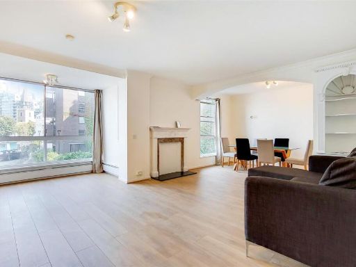 2 bedroom flat for sale in VALIANT HOUSE, VICARAGE CRESCENT, London, SW11 — £600,000 • 2 bed • 1 bath • 956 ft²
 2 bedroom maisonette for sale in Sunbury Lane,
Battersea Park, SW11 — £710,000 • 2 bed • 1 bath • 885 ft²
2 bedroom maisonette for sale in Sunbury Lane,
Battersea Park, SW11 — £710,000 • 2 bed • 1 bath • 885 ft² 2 bedroom apartment for sale in Battersea Church Road, London, SW11 — £400,000 • 2 bed • 1 bath • 630 ft²
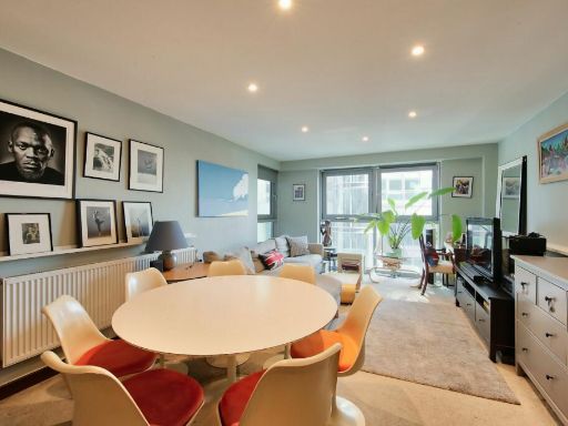 2 bedroom flat for sale in Bridges Court Road, Battersea, SW11 — £499,000 • 2 bed • 1 bath • 742 ft²
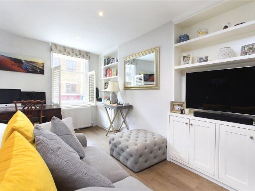 2 bedroom flat for sale in Battersea High Street,
Battersea Park, SW11 — £475,000 • 2 bed • 1 bath • 576 ft²
2 bedroom flat for sale in Battersea High Street,
Battersea Park, SW11 — £475,000 • 2 bed • 1 bath • 576 ft²
Meta
- {
"@context": "https://schema.org",
"@type": "Residence",
"name": "2 bedroom apartment for sale in Battersea Church Road, Wand…",
"description": "",
"url": "https://propertypiper.co.uk/property/f7cac0e2-2e38-4b29-b9b6-878c3ca4853b",
"image": "https://image-a.propertypiper.co.uk/ca1817f6-1799-417d-84aa-d599f163245f-1024.jpeg",
"address": {
"@type": "PostalAddress",
"streetAddress": "SPARKFORD HOUSE FLAT 44 BATTERSEA CHURCH ROAD LONDON",
"postalCode": "SW11 3NQ",
"addressLocality": "Wandsworth",
"addressRegion": "Battersea",
"addressCountry": "England"
},
"geo": {
"@type": "GeoCoordinates",
"latitude": 51.476462595823314,
"longitude": -0.17384870944800132
},
"numberOfRooms": 2,
"numberOfBathroomsTotal": 1,
"floorSize": {
"@type": "QuantitativeValue",
"value": 624,
"unitCode": "FTK"
},
"offers": {
"@type": "Offer",
"price": 375000,
"priceCurrency": "GBP",
"availability": "https://schema.org/InStock"
},
"additionalProperty": [
{
"@type": "PropertyValue",
"name": "Feature",
"value": "contemporary"
},
{
"@type": "PropertyValue",
"name": "Feature",
"value": "small bedroom"
},
{
"@type": "PropertyValue",
"name": "Feature",
"value": "parquet flooring"
},
{
"@type": "PropertyValue",
"name": "Feature",
"value": "standard ceiling"
},
{
"@type": "PropertyValue",
"name": "Feature",
"value": "natural light"
},
{
"@type": "PropertyValue",
"name": "Feature",
"value": "minimalist"
},
{
"@type": "PropertyValue",
"name": "Feature",
"value": "modern design"
},
{
"@type": "PropertyValue",
"name": "Feature",
"value": "bedroom"
},
{
"@type": "PropertyValue",
"name": "Feature",
"value": "mid-century modern"
},
{
"@type": "PropertyValue",
"name": "Feature",
"value": "wall-mounted light"
},
{
"@type": "PropertyValue",
"name": "Feature",
"value": "parquet flooring"
},
{
"@type": "PropertyValue",
"name": "Feature",
"value": "small room"
},
{
"@type": "PropertyValue",
"name": "Feature",
"value": "modernization needed"
}
]
}
High Res Floorplan Images
Compatible Floorplan Images
FloorplanImages Thumbnail