DE21 5LL - 4 bedroom chalet for sale in Rectory Lane, Breadsall, DE21
View on Property Piper
4 bedroom chalet for sale in Rectory Lane, Breadsall, DE21
Property Details
- Price: £450000
- Bedrooms: 4
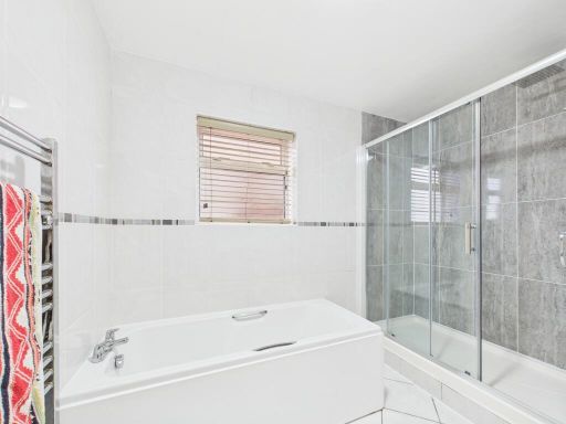
- Bathrooms: 1
- Property Type: undefined
- Property SubType: undefined
Image Descriptions
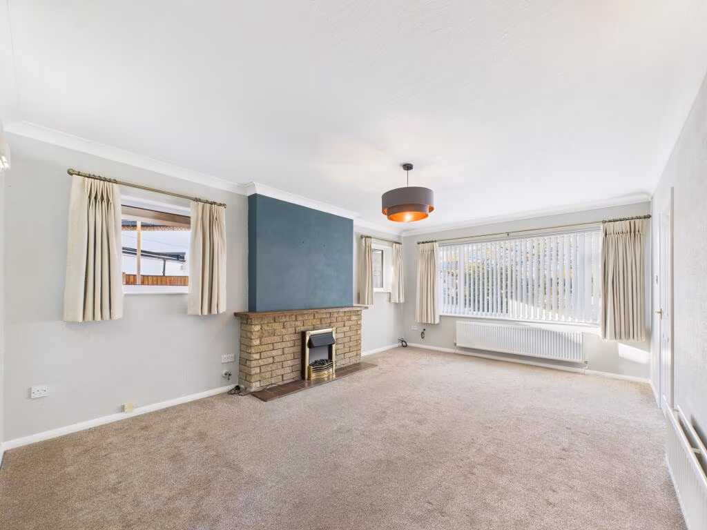
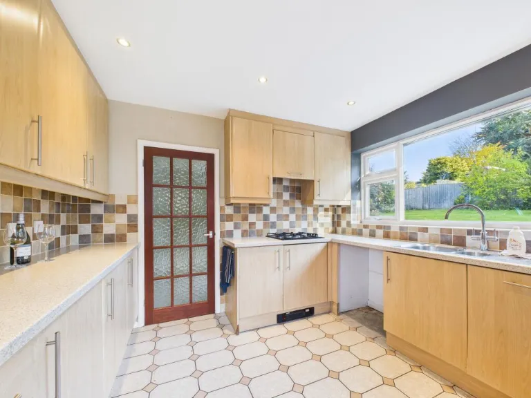
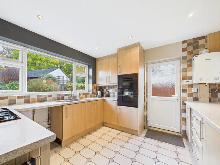
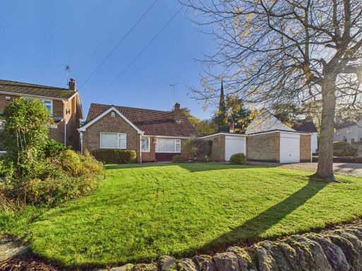
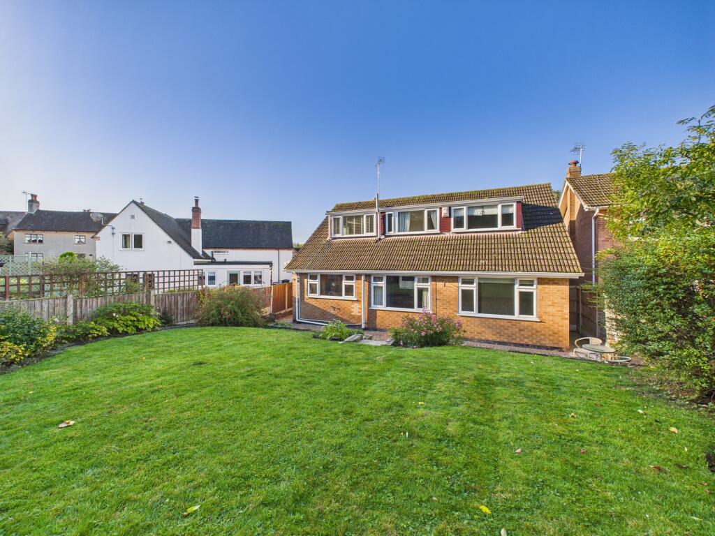
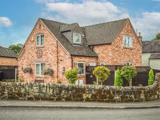
- detached bungalow Mid-20th Century
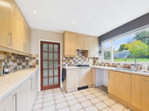
- kitchen modern
Floorplan Description
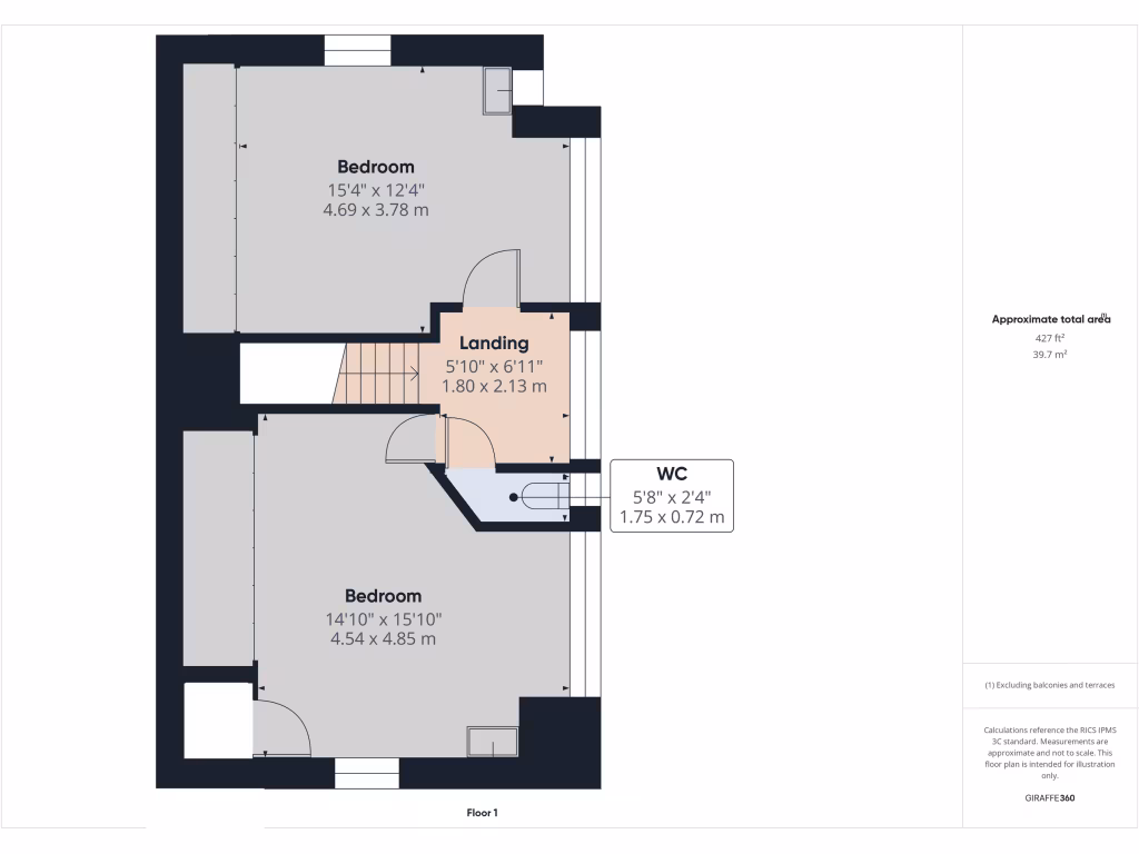
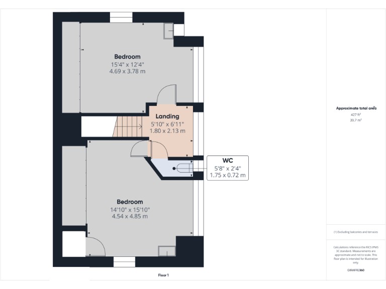
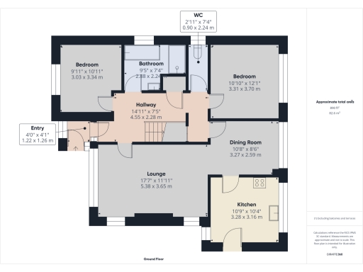
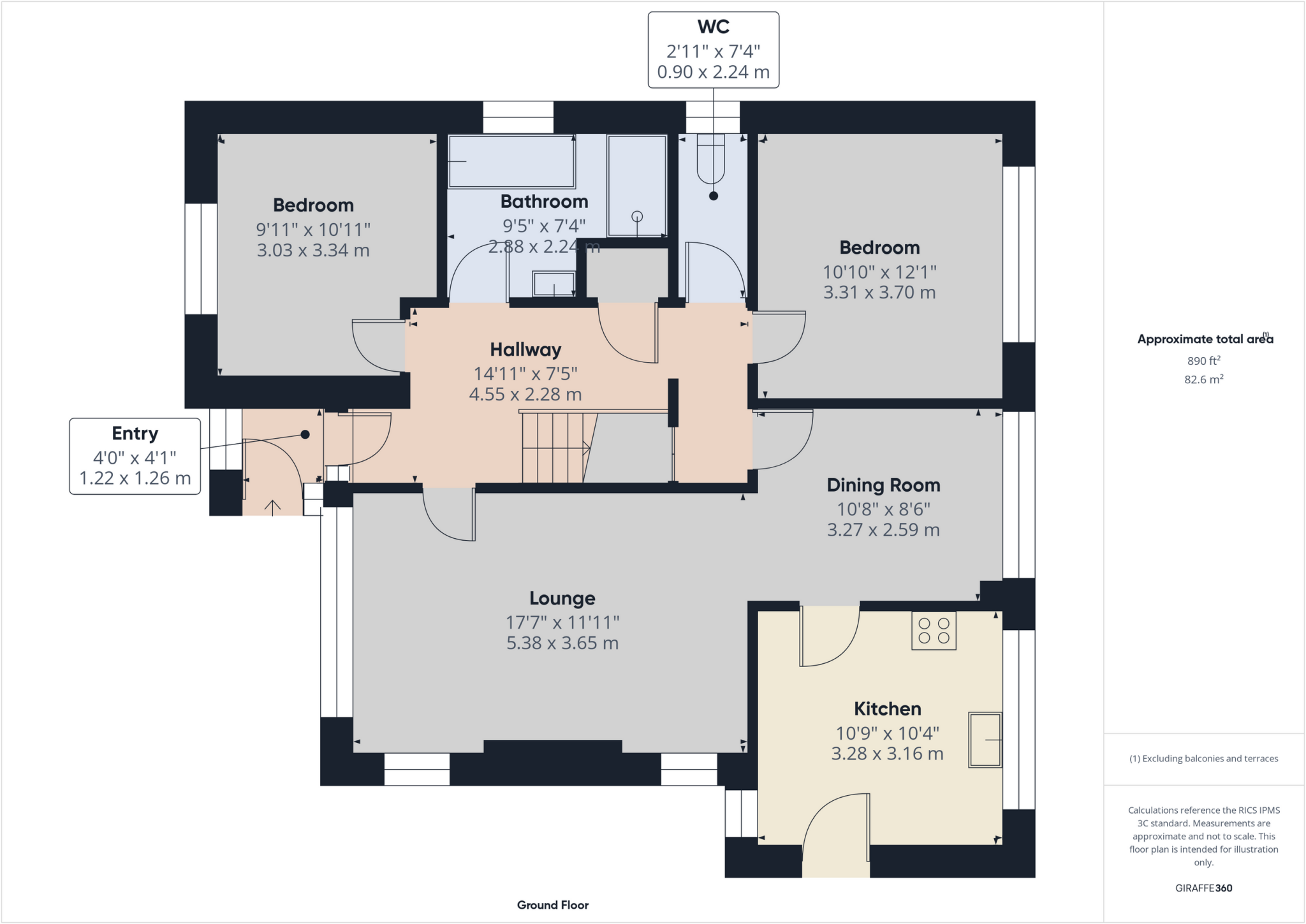
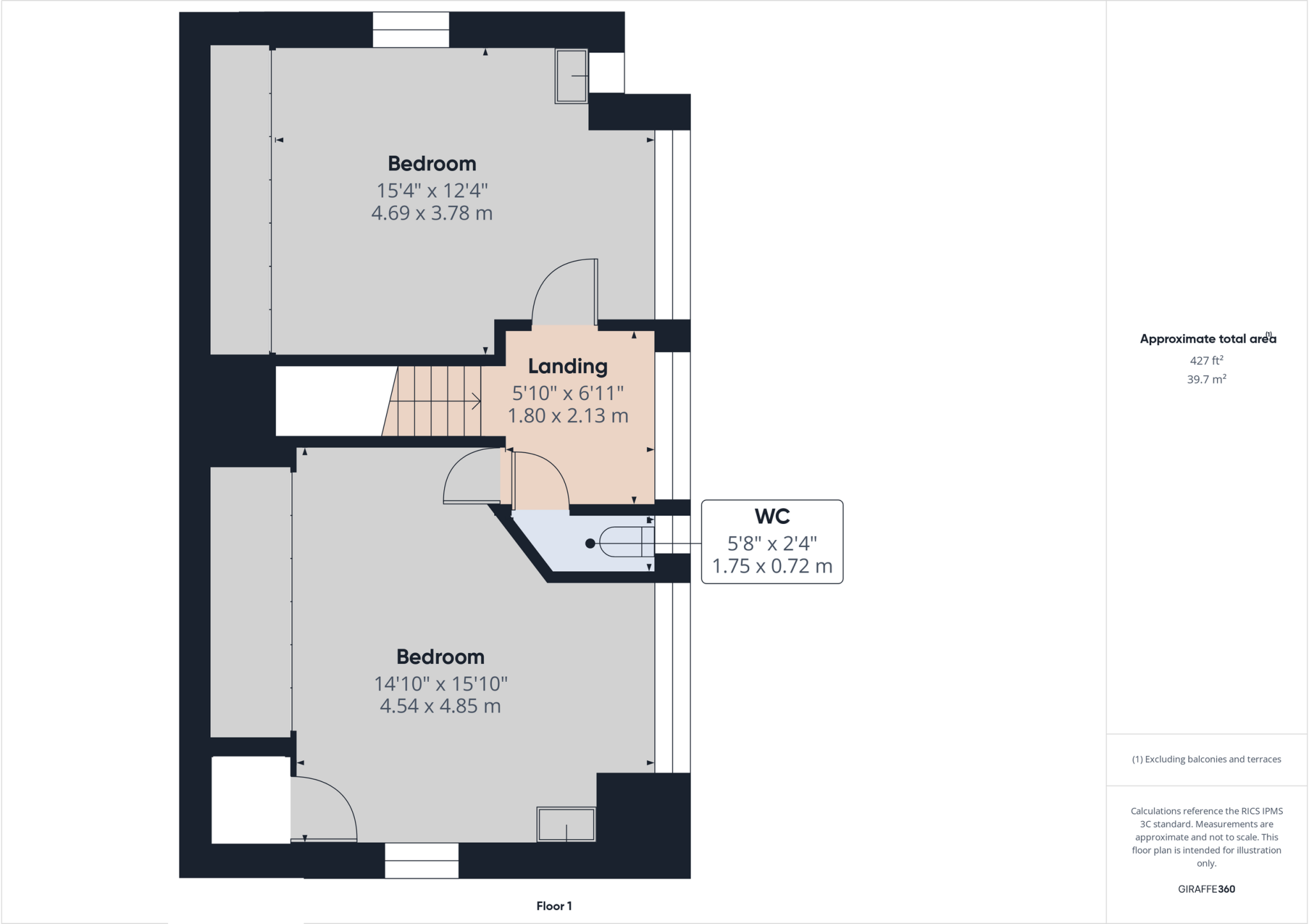
- Ground floor plan with lounge, kitchen, dining room, two bedrooms, bathroom, WC, hallway and entry.
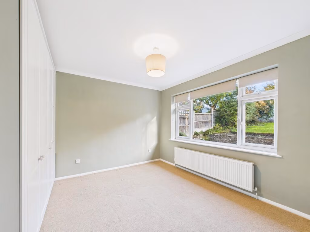
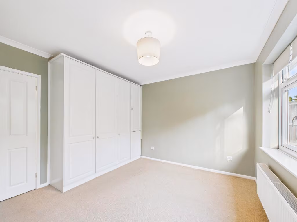
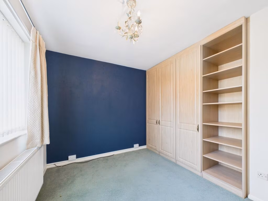
Rooms
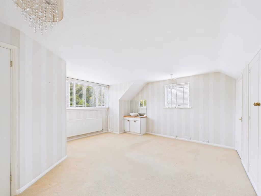
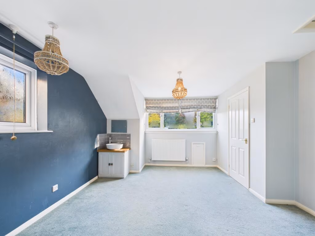
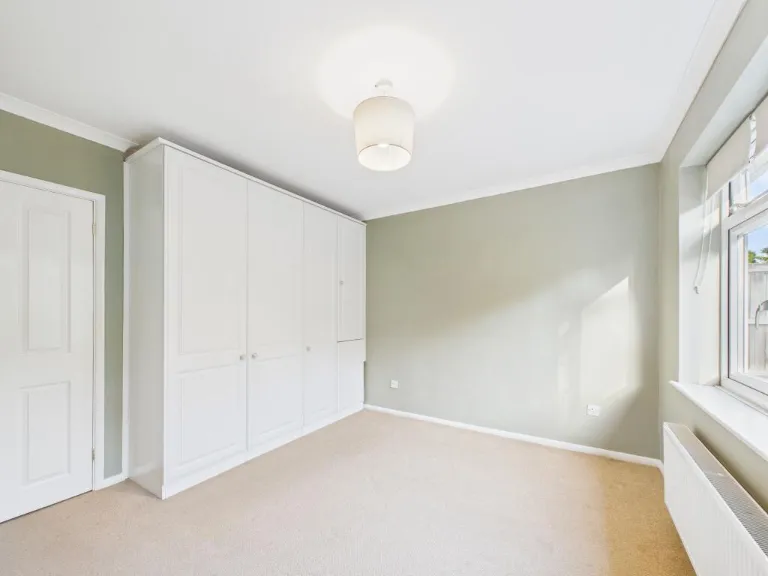
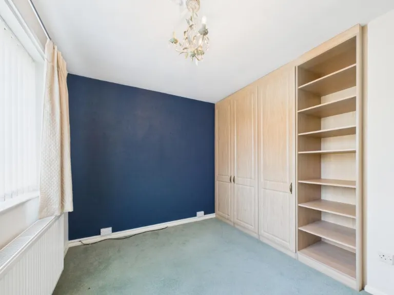
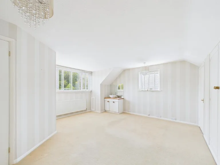
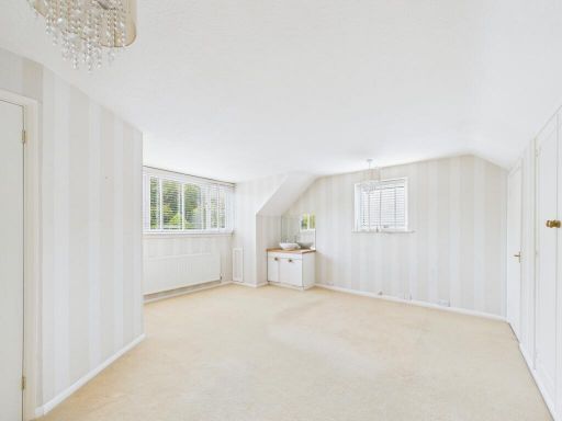
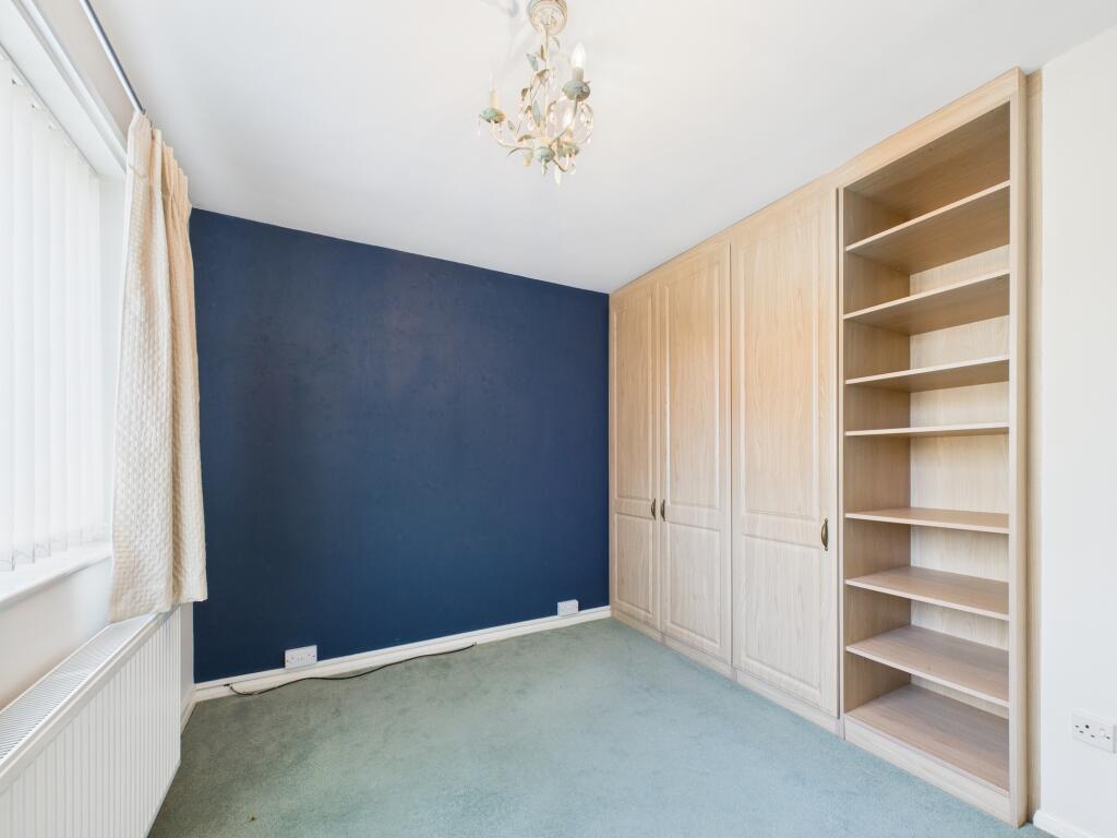
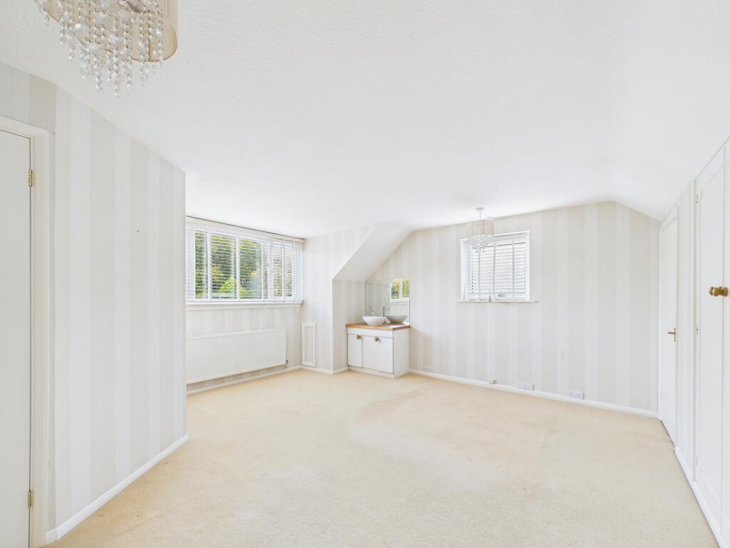
- Bedroom:
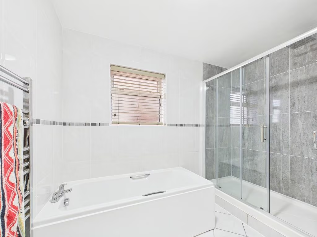
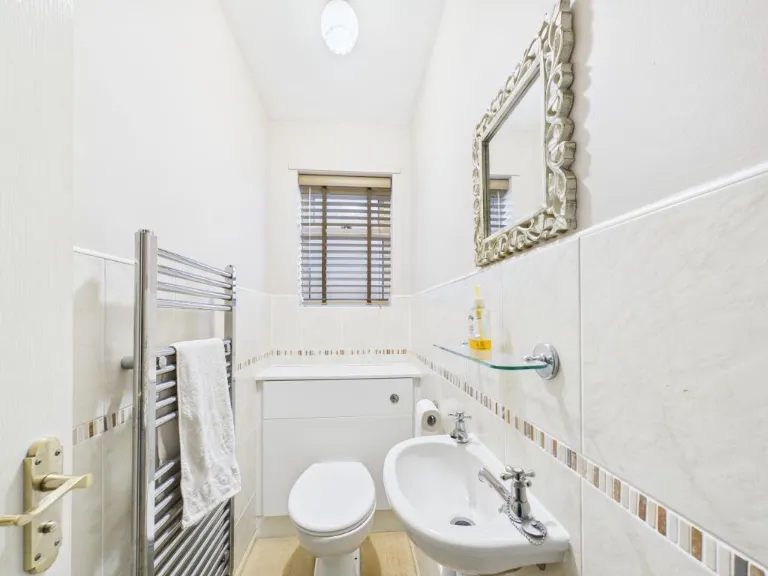
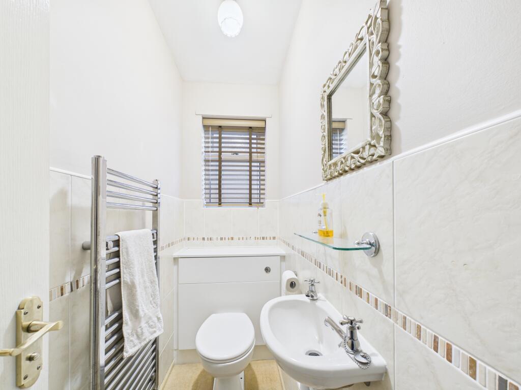
- Bathroom:
- WC:
- Bedroom:
- Hallway:
- Dining Room:
- Lounge:
- Kitchen:
- Entry:
- Bedroom:
- Bedroom:
- Landing:
- WC:
Textual Property Features
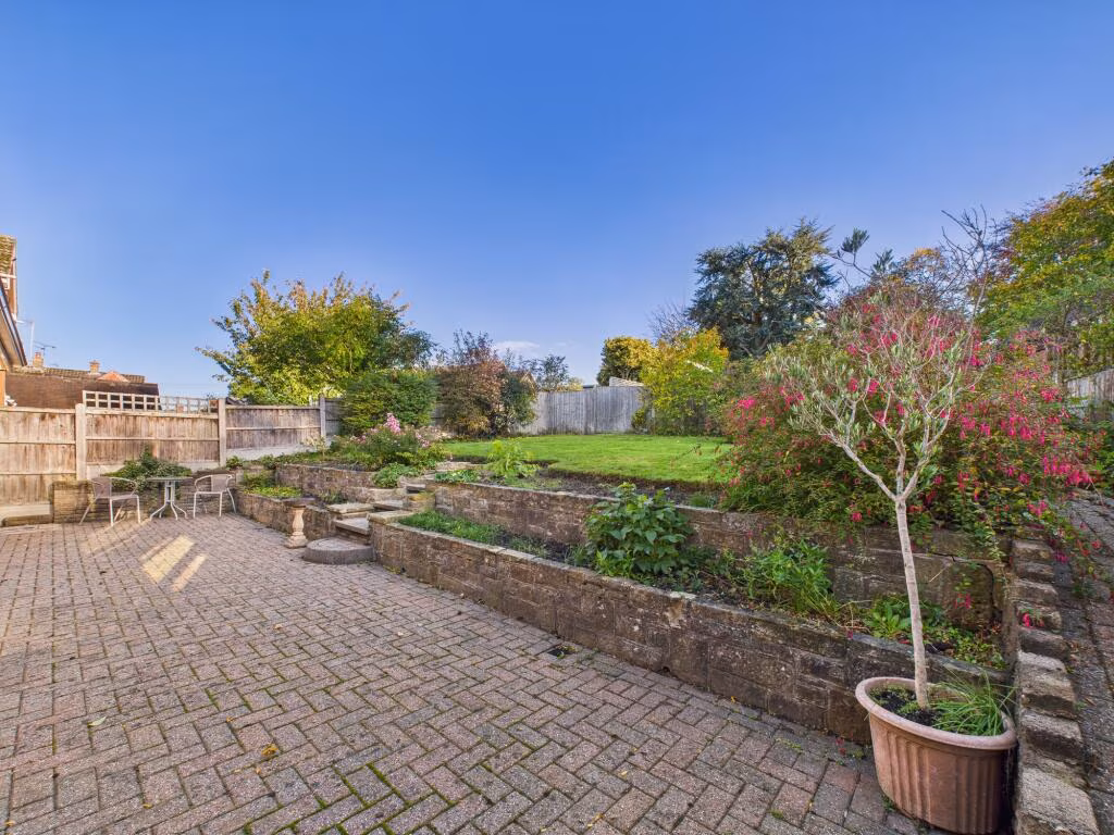
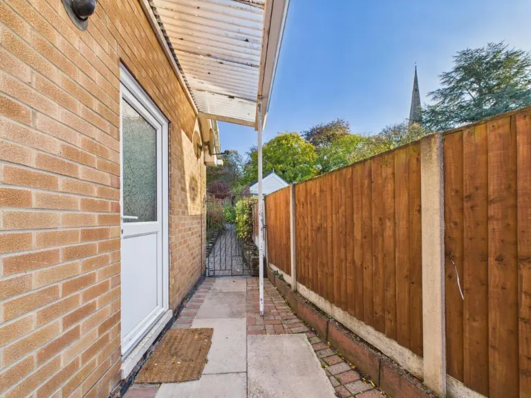
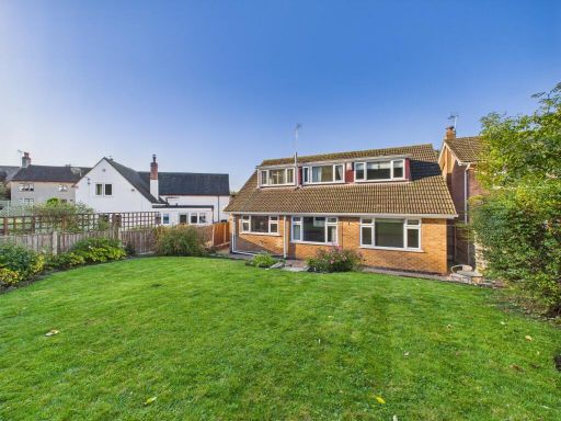
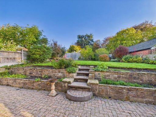
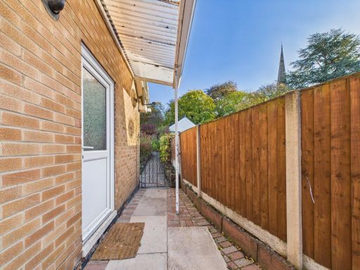
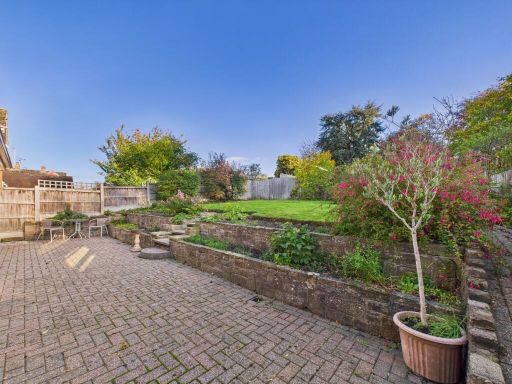
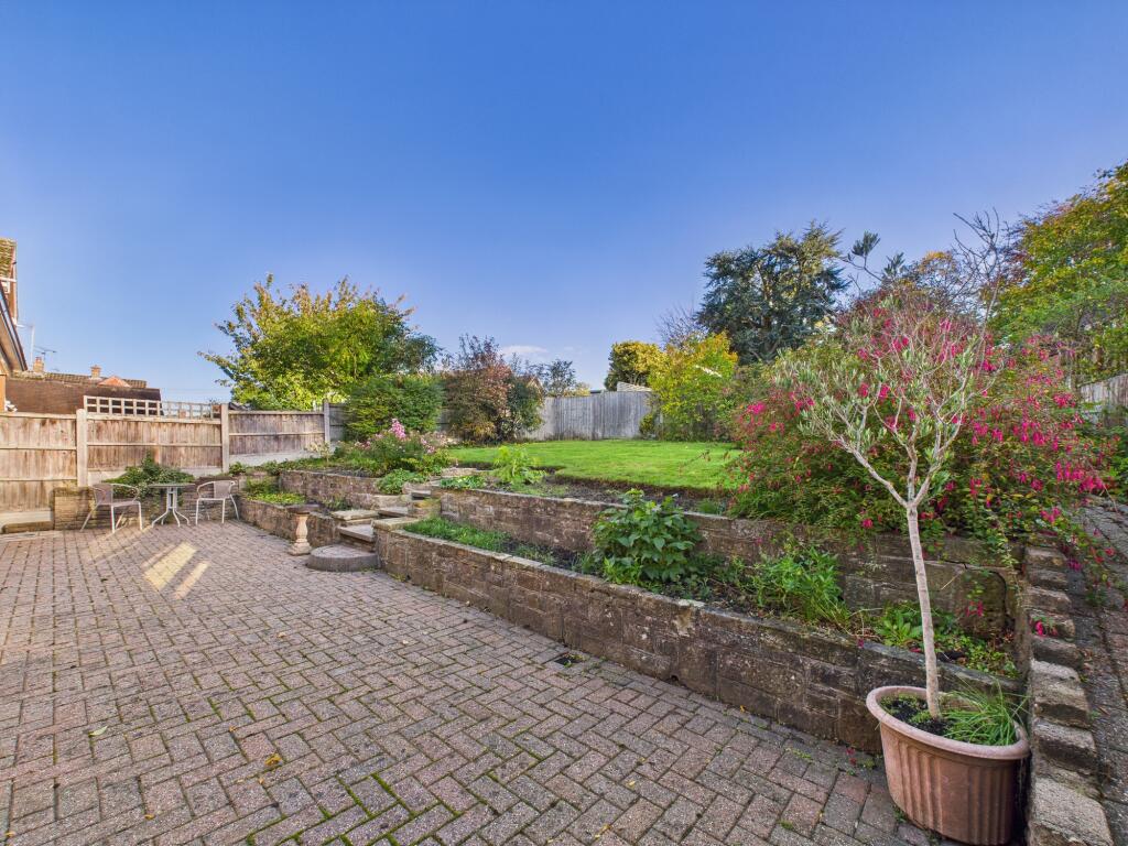
- Has Garden
- Chain Free
- Success
Detected Visual Features
- detached
- bungalow
- mid-20th century
- garage
- garden
- spacious
- well-maintained
- single-story
- residential
- modern kitchen
- medium-sized room
- standard ceiling
- tile backsplash
- wood cabinets
- neutral colors
- garden view
EPC Details
- Fully double glazed
- Cavity wall, filled cavity
- Boiler and radiators, mains gas
- Low energy lighting in 67% of fixed outlets
- Solid, no insulation (assumed)
Nearby Schools
- Cherry Tree Hill Primary School
- St Alban's Catholic Voluntary Academy
- Chaddesden Park Primary School
- Lees Brook Academy
- Beaufort Community Primary School
- Roe Farm Primary School
- Walter Evans Church of England Aided Primary School
- Portway Junior School
- Breadsall CofE VC Primary School
- Cavendish Close Junior Academy
- Saint Benedict, A Catholic Voluntary Academy
- Old Vicarage School
- Cavendish Close Infant School
- St Mary's Catholic Voluntary Academy
- Da Vinci Academy
- Little Eaton Primary School
- UTC Derby Pride Park
- Castleward Spencer Academy
- Meadow Farm Community Primary School
- Landau Forte College
- Derwent Primary School
- Emmanuel School (Derby) Limited
- Breadsall Hill Top Primary School
- Parkview Primary School
- Portway Infant School
Nearest General Shops
- Id: 4032165536
- Tags:
- Addr:
- City: Derby
- Place: Derby Garden Centre
- Postcode: DE21 5DB
- Street: Alfreton Road
- Fhrs:
- Name: Brown and Green
- Shop: deli
- Source:
- Website: http://www.brown-and-green.co.uk/derby
- TagsNormalized:
- Lat: 52.9604217
- Lon: -1.4583405
- FullGeoHash: gcqvqc4hf4nt
- PartitionGeoHash: gcqv
- Images:
- FoodStandards:
- Id: 251945
- FHRSID: 251945
- LocalAuthorityBusinessID: 104623
- BusinessName: Brown & Green
- BusinessType: Restaurant/Cafe/Canteen
- BusinessTypeID: 1
- AddressLine1: null
- AddressLine2: Alfreton Road
- AddressLine3: null
- AddressLine4: Little Eaton
- PostCode: DE21 5DB
- RatingValue: 4
- RatingKey: fhrs_4_en-GB
- RatingDate: 2021-12-10
- LocalAuthorityCode: 066
- LocalAuthorityName: Erewash
- LocalAuthorityWebSite: http://www.erewash.gov.uk/
- LocalAuthorityEmailAddress: environmentalhealth@erewash.gov.uk
- Scores:
- Hygiene: 0
- Structural: 10
- ConfidenceInManagement: 10
- NewRatingPending: false
- Geocode:
- Longitude: -1.45844100000000
- Latitude: 52.96108400000000
- Distance: 828
,- Id: 113745810
- Tags:
- Building: yes
- Name: Garden and Home Derby
- Shop: garden_centre
- Source: survey
- TagsNormalized:
- Lat: 52.9603617
- Lon: -1.4580868
- FullGeoHash: gcqvqc4k2ngx
- PartitionGeoHash: gcqv
- Images:
- FoodStandards: null
- Distance: 812.3
,- Id: 726399396
- Tags:
- Name: Oakwood Cars
- Shop: car
- Source: survey
- TagsNormalized:
- Lat: 52.9486806
- Lon: -1.4460443
- FullGeoHash: gcqvpp502trn
- PartitionGeoHash: gcqv
- Images:
- FoodStandards: null
- Distance: 725.8
}
Nearest Religious buildings
- Id: 54973921
- Tags:
- Addr:
- City: Derby
- Country: GB
- Housenumber: 113
- Postcode: DE21 5DF
- Street: Alfreton Road
- Village: Little Eaton
- Amenity: place_of_worship
- Building: church
- Denomination: united_reformed
- Name: Little Eaton United Reformed Church
- Religion: christian
- TagsNormalized:
- place of worship
- church
- united reformed
- christian
- Lat: 52.967276
- Lon: -1.4609678
- FullGeoHash: gcqvqf2hszzk
- PartitionGeoHash: gcqv
- Images:
- FoodStandards: null
- Distance: 1570.9
,- Id: 104072220
- Tags:
- Amenity: grave_yard
- Denomination: anglican
- Landuse: religious
- Religion: christian
- TagsNormalized:
- grave yard
- anglican
- religious
- christian
- Lat: 52.9541387
- Lon: -1.4487975
- FullGeoHash: gcqvr0100wfm
- PartitionGeoHash: gcqv
- Images:
- FoodStandards: null
- Distance: 134.5
,- Id: 104126667
- Tags:
- HE_ref: 1328833
- Addr:
- City: Derby
- Postcode: DE21 5LA
- Street: Moor Road
- Suburb: Breadsall
- Alt_name: All Saints' Church Breadsall
- Amenity: place_of_worship
- Building: church
- Denomination: anglican
- Listed_status: Grade I
- Name: All Saints' Church
- Religion: christian
- Source:
- Listed_status: Historic England
- Website: https://www.breadsallchurch.org.uk
- Wikidata: Q17525661
- Wikipedia: en:All Saints' Church, Breadsall
- TagsNormalized:
- place of worship
- church
- anglican
- christian
- Lat: 52.9542857
- Lon: -1.4491156
- FullGeoHash: gcqvr00c14m4
- PartitionGeoHash: gcqv
- Images:
- FoodStandards: null
- Distance: 108.9
}
Nearest Medical buildings
- Id: 1210961829
- Tags:
- Addr:
- City: Derby
- Housenumber: 2
- Postcode: DE21 5DJ
- Street: Barley Close
- Village: Little Eaton
- Amenity: pharmacy
- Healthcare: pharmacy
- Name: Peak Pharmacy
- Old_fhrs:
- Old_name: Manor Pharmacy
- Phone: +44 1332 834369
- Source: survey
- Website: https://www.peakpharmacy.co.uk/branch/peak-pharmacy-little-eaton/
- TagsNormalized:
- Lat: 52.969743
- Lon: -1.4617731
- FullGeoHash: gcqvqdze45yb
- PartitionGeoHash: gcqv
- Images:
- FoodStandards: null
- Distance: 1842.4
,- Id: 691677801
- Tags:
- Addr:
- City: Derby
- Housenumber: 10
- Postcode: DE21 5DH
- Street: The Town
- Village: Little Eaton
- Amenity: doctors
- Healthcare: doctor
- Name: Appletree Medical Practice
- Phone: +44 1332 842288
- Source: survey
- Website: https://www.appletreemedical.co.uk/
- TagsNormalized:
- doctor
- doctors
- health
- healthcare
- Lat: 52.9697169
- Lon: -1.4616961
- FullGeoHash: gcqvqdzdunbm
- PartitionGeoHash: gcqv
- Images:
- FoodStandards: null
- Distance: 1837.7
,- Id: 866788060
- Tags:
- Addr:
- City: Derby
- Postcode: DE21 2HT
- Suburb: Oakwood
- Amenity: doctors
- Building: yes
- Healthcare: doctor
- Name: Oakwood Medical Centre
- TagsNormalized:
- doctor
- doctors
- health
- healthcare
- Lat: 52.9422436
- Lon: -1.4328982
- FullGeoHash: gcqvpmudgj98
- PartitionGeoHash: gcqv
- Images:
- FoodStandards: null
- Distance: 1816.6
,- Id: 5701927749
- Tags:
- Addr:
- City: Derby
- Postcode: DE21 4RY
- Street: Wheatcroft Way
- Amenity: pharmacy
- Dispensing: yes
- Healthcare: pharmacy
- Name: Morrison's Pharmacy
- TagsNormalized:
- pharmacy
- health
- healthcare
- morrisons
- Lat: 52.9452145
- Lon: -1.4626079
- FullGeoHash: gcqvnwqunz2d
- PartitionGeoHash: gcqv
- Images:
- FoodStandards: null
- Distance: 1313.8
}
Nearest Airports
- Id: 11359528
- Tags:
- Aerodrome: international
- Aerodrome:type: public
- Aeroway: aerodrome
- Iata: EMA
- Icao: EGNX
- Is_in: Castle Donington,England,UK
- Name: East Midlands Airport
- Old_name: RAF Castle Donington
- Operator: Manchester Airports Holdings Limited
- Operator:type: private
- Ref: EMA
- Type: multipolygon
- Website: https://www.eastmidlandsairport.com/
- Wikidata: Q8977
- Wikipedia: en:East Midlands Airport
- TagsNormalized:
- airport
- international airport
- Lat: 52.8281122
- Lon: -1.3322143
- FullGeoHash: gcrh99jfj1vh
- PartitionGeoHash: gcrh
- Images:
- FoodStandards: null
- Distance: 16152.9
}
Nearest Leisure Facilities
- Id: 400666370
- Tags:
- Leisure: pitch
- Name: Wyvern Crown Green Bowls Club
- Sport: bowls
- TagsNormalized:
- pitch
- leisure
- bowls
- club
- sports
- Lat: 52.9540226
- Lon: -1.4444679
- FullGeoHash: gcqvppupt3q8
- PartitionGeoHash: gcqv
- Images:
- FoodStandards: null
- Distance: 419.7
,- Id: 400666371
- Tags:
- Leisure: playground
- Source: survey
- TagsNormalized:
- Lat: 52.9532192
- Lon: -1.4459397
- FullGeoHash: gcqvppg4g5t0
- PartitionGeoHash: gcqv
- Images:
- FoodStandards: null
- Distance: 351
,- Id: 4032008872
- Tags:
- Leisure: fitness_station
- Source: survey
- Sport: fitness
- TagsNormalized:
- fitness
- fitness station
- station
- leisure
- sports
- Lat: 52.9530052
- Lon: -1.446137
- FullGeoHash: gcqvppfcwed5
- PartitionGeoHash: gcqv
- Images:
- FoodStandards: null
- Distance: 350.5
,- Id: 400666368
- Tags:
- Leisure: pitch
- Source: survey
- Sport: cricket
- TagsNormalized:
- pitch
- leisure
- cricket
- sports
- Lat: 52.953968
- Lon: -1.4459751
- FullGeoHash: gcqvppgp4r4g
- PartitionGeoHash: gcqv
- Images:
- FoodStandards: null
- Distance: 321.5
,- Id: 104072236
- Tags:
- Leisure: pitch
- Source: survey;Bing
- Sport: tennis
- TagsNormalized:
- Lat: 52.9533651
- Lon: -1.4470157
- FullGeoHash: gcqvppf7dndy
- PartitionGeoHash: gcqv
- Images:
- FoodStandards: null
- Distance: 279.5
}
Nearest Tourist attractions
- Id: 383265490
- Tags:
- Operator: Derbyshire Scouts
- Tourism: camp_site
- TagsNormalized:
- Lat: 52.9729138
- Lon: -1.4441537
- FullGeoHash: gcqvr5kmsfbg
- PartitionGeoHash: gcqv
- Images:
- FoodStandards: null
- Distance: 2084.2
,- Id: 383265220
- Tags:
- Operator: Derbyshire Scouts
- Tourism: camp_site
- TagsNormalized:
- Lat: 52.9729827
- Lon: -1.4462445
- FullGeoHash: gcqvr56vup9y
- PartitionGeoHash: gcqv
- Images:
- FoodStandards: null
- Distance: 2067
,- Id: 381631745
- Tags:
- Operator: Derbyshire Scouts
- Tourism: camp_site
- TagsNormalized:
- Lat: 52.9725351
- Lon: -1.4481583
- FullGeoHash: gcqvr537rkqb
- PartitionGeoHash: gcqv
- Images:
- FoodStandards: null
- Distance: 2003
}
Nearest Train stations
- Id: 6415346590
- Tags:
- Name: Belper
- Naptan:
- Network: National Rail
- Public_transport: station
- Railway: station
- Ref:
- Source: NPE
- Train: yes
- Wikidata: Q3148981
- Wikipedia: en:Belper railway station
- TagsNormalized:
- Lat: 53.0242729
- Lon: -1.4825631
- FullGeoHash: gcqvwkb2vbbu
- PartitionGeoHash: gcqv
- Images:
- FoodStandards: null
- Distance: 8037.7
,- Id: 252838671
- Tags:
- Name: Peartree
- Naptan:
- Network: National Rail
- Note: Only a few services call here, I would not consider it a railway=halt since it has proper platforms and it isn't a request stop
- Public_transport: station
- Railway: station
- Ref:
- Source: NPE
- Start_date: 1839
- Wikidata: Q7158389
- Wikipedia: en:Peartree railway station
- TagsNormalized:
- Lat: 52.8976023
- Lon: -1.4722913
- FullGeoHash: gcquymxyv5u0
- PartitionGeoHash: gcqu
- Images:
- FoodStandards: null
- Distance: 6500
,- Id: 2132540013
- Tags:
- Name: Spondon
- Naptan:
- Network: National Rail
- Public_transport: station
- Railway: station
- Ref:
- Source: NPE
- Wikidata: Q7578950
- Wikipedia: en:Spondon railway station
- TagsNormalized:
- Lat: 52.9120948
- Lon: -1.4108169
- FullGeoHash: gcqvpbkem96e
- PartitionGeoHash: gcqv
- Images:
- FoodStandards: null
- Distance: 5427.3
,- Id: 6415346589
- Tags:
- Name: Duffield
- Naptan:
- Network: National Rail
- Public_transport: station
- Railway: station
- Ref:
- Source: NPE
- Wikidata: Q4027193
- Wikipedia: en:Duffield railway station
- TagsNormalized:
- Lat: 52.9882284
- Lon: -1.4858584
- FullGeoHash: gcqvqnnnbcxw
- PartitionGeoHash: gcqv
- Images:
- FoodStandards: null
- Distance: 4421.4
,- Id: 5871807868
- Tags:
- Name: Derby
- Naptan:
- Network: National Rail
- Operator: East Midlands Railway
- Public_transport: station
- Railway: station
- Ref:
- Train: yes
- Wheelchair: yes
- Wikidata: Q3398679
- Wikipedia: en:Derby railway station
- TagsNormalized:
- Lat: 52.9162127
- Lon: -1.4626517
- FullGeoHash: gcqvn9ngm9pb
- PartitionGeoHash: gcqv
- Images:
- FoodStandards: null
- Distance: 4341.8
}
Nearest Bus stations and stops
- Id: 392448074
- Tags:
- Bus: yes
- Highway: bus_stop
- Name: Starbucks
- Public_transport: platform
- TagsNormalized:
- Lat: 52.9568541
- Lon: -1.4596021
- FullGeoHash: gcqvqb90hc1g
- PartitionGeoHash: gcqv
- Images:
- FoodStandards: null
- Distance: 649.7
,- Id: 441266134
- Tags:
- Bus: yes
- Highway: bus_stop
- Name: Starbucks
- Public_transport: platform
- TagsNormalized:
- Lat: 52.9571698
- Lon: -1.4591707
- FullGeoHash: gcqvqb93yggq
- PartitionGeoHash: gcqv
- Images:
- FoodStandards: null
- Distance: 638.2
,- Id: 3921009279
- Tags:
- Both_ways: yes
- Bus: yes
- Highway: bus_stop
- Name: Moor Road
- Public_transport: platform
- Shelter: yes
- Source: survey
- TagsNormalized:
- Lat: 52.9550125
- Lon: -1.4472673
- FullGeoHash: gcqvr04jk1z3
- PartitionGeoHash: gcqv
- Images:
- FoodStandards: null
- Distance: 232.4
,- Id: 3921009272
- Tags:
- Bus: yes
- Highway: bus_stop
- Name: Brookside Road / Church Lane
- Public_transport: platform
- Shelter: yes
- Source: survey
- TagsNormalized:
- Lat: 52.9531085
- Lon: -1.4489593
- FullGeoHash: gcqvppbfhycs
- PartitionGeoHash: gcqv
- Images:
- FoodStandards: null
- Distance: 200
,- Id: 8464055018
- Tags:
- Bus: yes
- Highway: bus_stop
- Public_transport: platform
- TagsNormalized:
- Lat: 52.953812
- Lon: -1.4518573
- FullGeoHash: gcqvnzyy3608
- PartitionGeoHash: gcqv
- Images:
- FoodStandards: null
- Distance: 117.4
}
Nearest Hotels
- Id: 111597271
- Tags:
- Addr:
- City: Derby
- Postcode: DE21 6DA
- Street: Nottingham Road
- Brand: Travelodge
- Brand:wikidata: Q9361374
- Brand:wikipedia: en:Travelodge UK
- Building: yes
- Fhrs:
- Authority: Derby City
- Id: 925182
- Local_authority_id: 142849
- Internet_access: wlan
- Internet_access:fee: customers
- Internet_access:ssid: Travelodge WiFi
- Name: Travelodge
- Postal_code: DE21 6DA
- Tourism: hotel
- TagsNormalized:
- Lat: 52.926946
- Lon: -1.4630566
- FullGeoHash: gcqvnen9u3cf
- PartitionGeoHash: gcqv
- Images:
- FoodStandards: null
- Distance: 3183.6
,- Id: 5424501866
- Tags:
- Addr:
- City: Derby
- Housename: The Mill House
- Postcode: DE22 1DZ
- Street: Haslams Lane
- Fhrs:
- Name: The Mill House
- Tourism: hotel
- Website: https://thewestmillvenue.com/accommodation/
- TagsNormalized:
- Lat: 52.9438312
- Lon: -1.4750892
- FullGeoHash: gcqvnqju5vmy
- PartitionGeoHash: gcqv
- Images:
- FoodStandards: null
- Distance: 2026.8
,- Id: 359203079
- Tags:
- Addr:
- City: Ilkeston
- Postcode: DE7 6DL
- Street: Moor Road
- Brand: Marriott
- Brand:wikidata: Q1141173
- Brand:wikipedia: en:Marriott International
- Building: yes
- Fhrs:
- Name: Breadsall Priory
- Operator: Marriott
- Source:
- Tourism: hotel
- TagsNormalized:
- Lat: 52.9688073
- Lon: -1.4334778
- FullGeoHash: gcqvr6sjtt37
- PartitionGeoHash: gcqv
- Images:
- FoodStandards: null
- Distance: 1956
}
Tags
- detached
- bungalow
- mid-20th century
- garage
- garden
- spacious
- well-maintained
- single-story
- residential
- modern kitchen
- medium-sized room
- standard ceiling
- tile backsplash
- wood cabinets
- neutral colors
- garden view
Local Market Stats
- Average Price/sqft: £235
- Avg Income: £39300
- Rental Yield: 4.5%
- Social Housing: 13%
- Planning Success Rate: 92%
Similar Properties
 4 bedroom detached house for sale in Sign Post Corner, Breadsall Village, Derby, DE21 — £529,950 • 4 bed • 2 bath • 1415 ft²
 5 bedroom detached house for sale in Darwin Fields Close, Breadsall Village Derby, DE21 — £750,000 • 5 bed • 4 bath • 2507 ft²
 3 bedroom semi-detached bungalow for sale in Brookfields Drive, Breadsall, Derby, DE21 — £325,000 • 3 bed • 2 bath • 1242 ft²
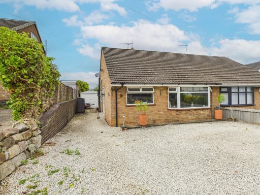 2 bedroom semi-detached bungalow for sale in Brookfields Drive, Breadsall, DE21 — £240,000 • 2 bed • 1 bath • 626 ft²
 4 bedroom detached house for sale in Brookside Road, Breadsall, DE21 — £425,000 • 4 bed • 2 bath • 1586 ft²
 3 bedroom semi-detached house for sale in Friday Lane, Breadsall, DE21 — £290,000 • 3 bed • 2 bath • 947 ft²
Meta
- {
"@context": "https://schema.org",
"@type": "Residence",
"name": "4 bedroom chalet for sale in Rectory Lane, Breadsall, DE21",
"description": "",
"url": "https://propertypiper.co.uk/property/ee18df49-4691-4cc1-bd55-87df59c08c95",
"image": "https://image-a.propertypiper.co.uk/98bd38fa-bd1e-479e-b44b-7a9b26be61c1-1024.jpeg",
"address": {
"@type": "PostalAddress",
"streetAddress": "14, Rectory Lane, Breadsall",
"postalCode": "DE21 5LL",
"addressLocality": "Erewash",
"addressRegion": "Mid Derbyshire",
"addressCountry": "England"
},
"geo": {
"@type": "GeoCoordinates",
"latitude": 52.95458521900137,
"longitude": -1.4506635713497187
},
"numberOfRooms": 4,
"numberOfBathroomsTotal": 1,
"floorSize": {
"@type": "QuantitativeValue",
"value": 1357,
"unitCode": "FTK"
},
"offers": {
"@type": "Offer",
"price": 450000,
"priceCurrency": "GBP",
"availability": "https://schema.org/InStock"
},
"additionalProperty": [
{
"@type": "PropertyValue",
"name": "Feature",
"value": "detached"
},
{
"@type": "PropertyValue",
"name": "Feature",
"value": "bungalow"
},
{
"@type": "PropertyValue",
"name": "Feature",
"value": "mid-20th century"
},
{
"@type": "PropertyValue",
"name": "Feature",
"value": "garage"
},
{
"@type": "PropertyValue",
"name": "Feature",
"value": "garden"
},
{
"@type": "PropertyValue",
"name": "Feature",
"value": "spacious"
},
{
"@type": "PropertyValue",
"name": "Feature",
"value": "well-maintained"
},
{
"@type": "PropertyValue",
"name": "Feature",
"value": "single-story"
},
{
"@type": "PropertyValue",
"name": "Feature",
"value": "residential"
},
{
"@type": "PropertyValue",
"name": "Feature",
"value": "modern kitchen"
},
{
"@type": "PropertyValue",
"name": "Feature",
"value": "medium-sized room"
},
{
"@type": "PropertyValue",
"name": "Feature",
"value": "standard ceiling"
},
{
"@type": "PropertyValue",
"name": "Feature",
"value": "tile backsplash"
},
{
"@type": "PropertyValue",
"name": "Feature",
"value": "wood cabinets"
},
{
"@type": "PropertyValue",
"name": "Feature",
"value": "neutral colors"
},
{
"@type": "PropertyValue",
"name": "Feature",
"value": "garden view"
}
]
}
High Res Floorplan Images
Compatible Floorplan Images
FloorplanImages Thumbnail