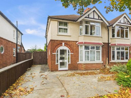
GL2 0LG - 4 bedroom semidetached house for sale in Oakleaze, Longleve…
View on Property Piper
4 bedroom semi-detached house for sale in Oakleaze, Longlevens, Gloucester, GL2
Property Details
- Price: £275000
- Bedrooms: 4
- Bathrooms: 1
- Property Type: undefined
- Property SubType: undefined
Image Descriptions
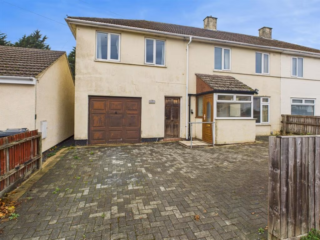
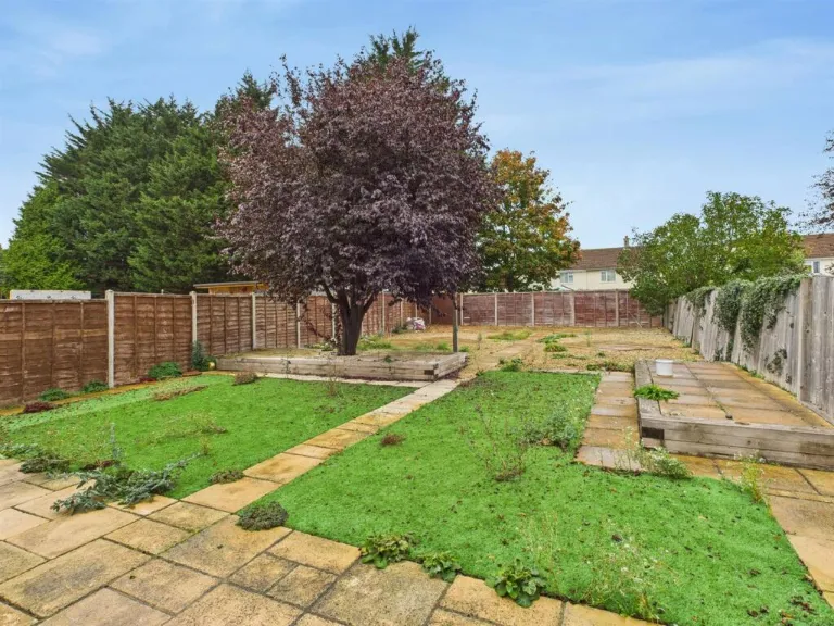
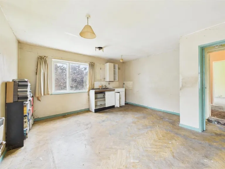
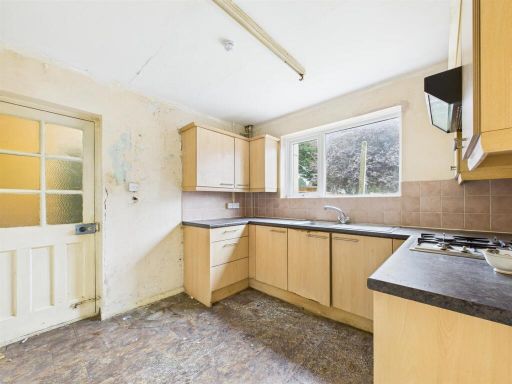
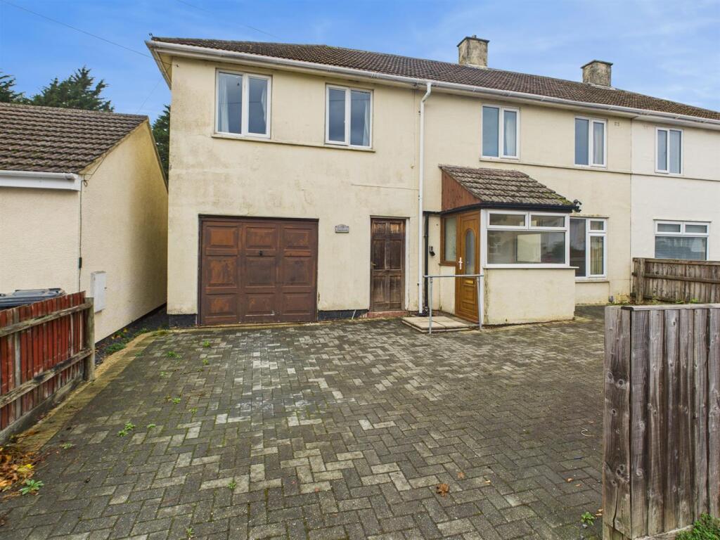
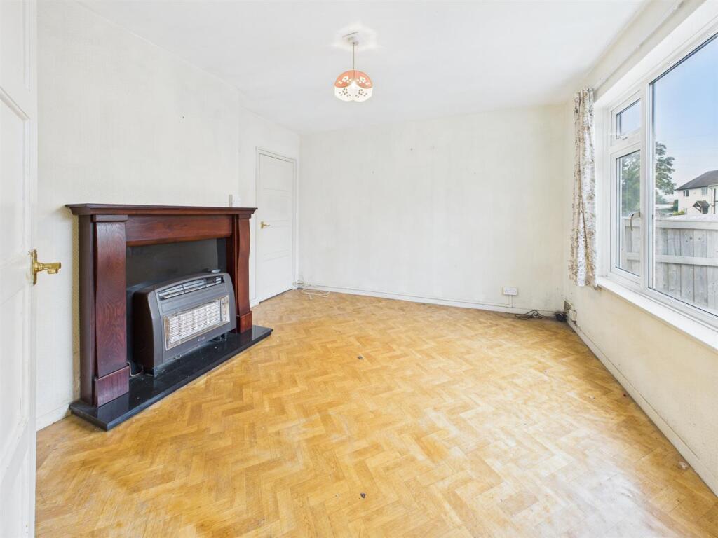
- semi-detached house post-war
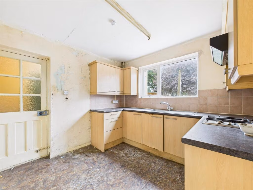
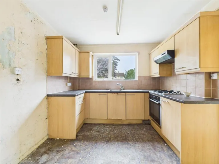
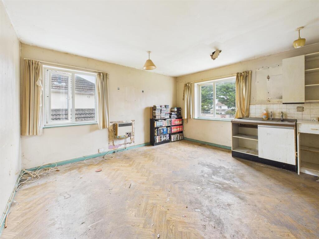
- kitchen 1970s/1980s
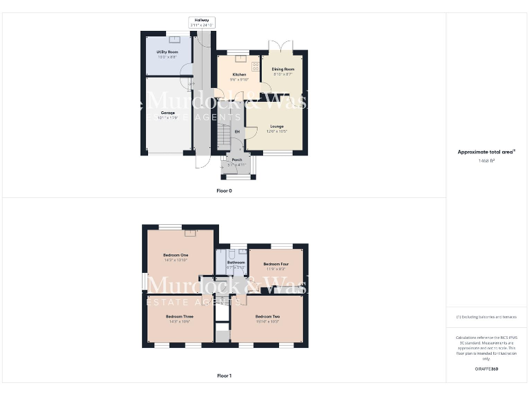
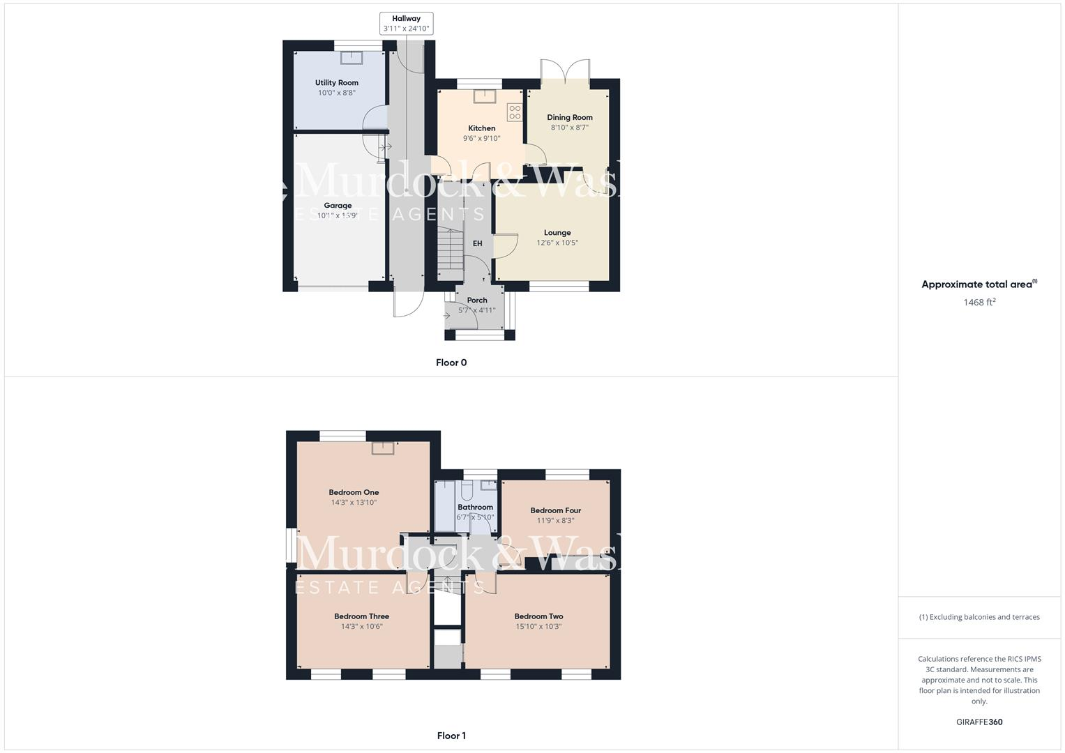
Rooms
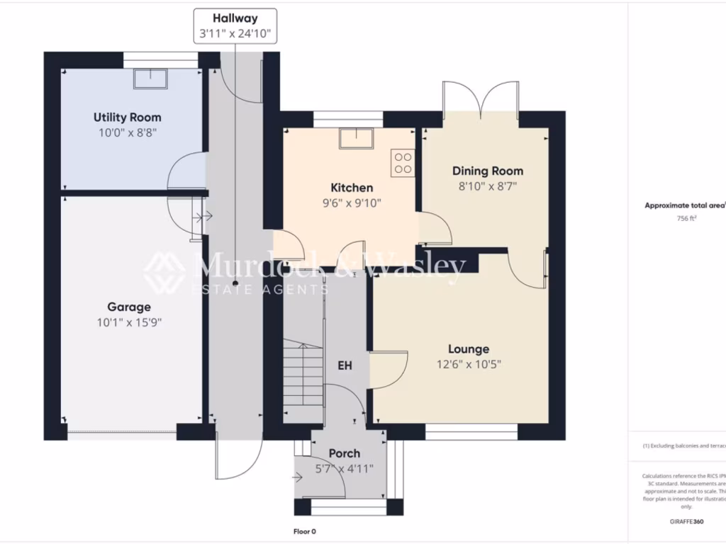
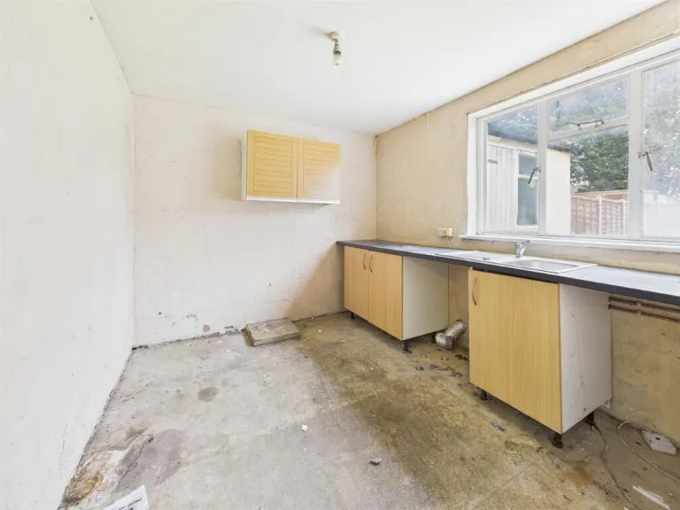
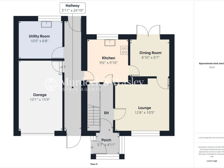
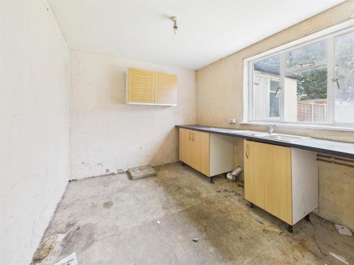
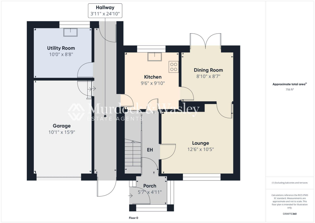
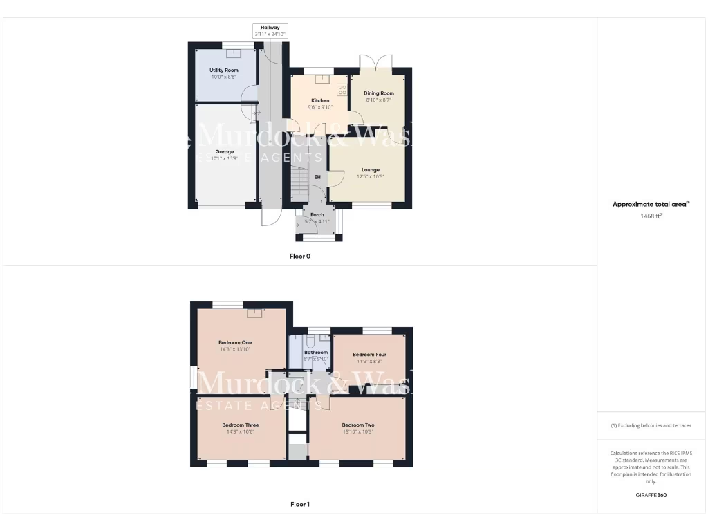
- Utility Room:
- Garage:
- Hallway:
- Kitchen:
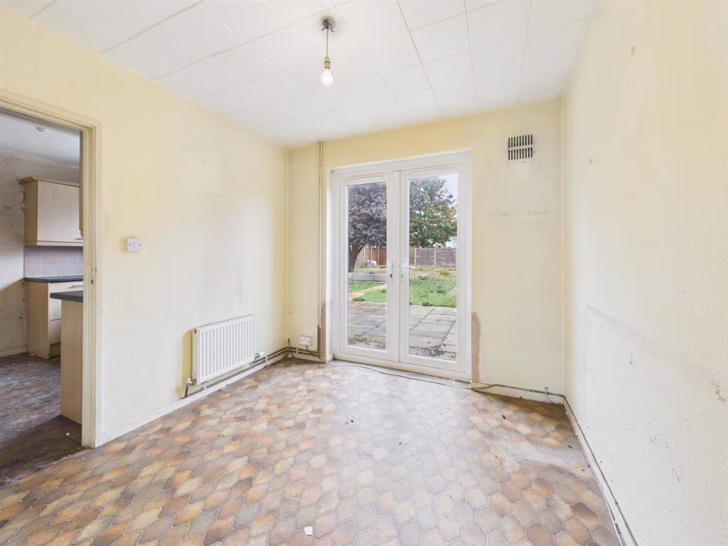
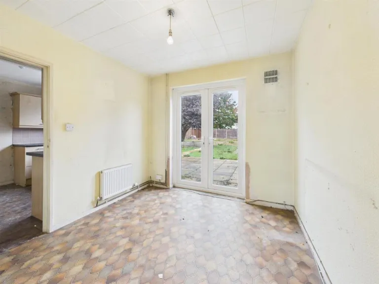
- Dining Room:
- Lounge:
- Porch:
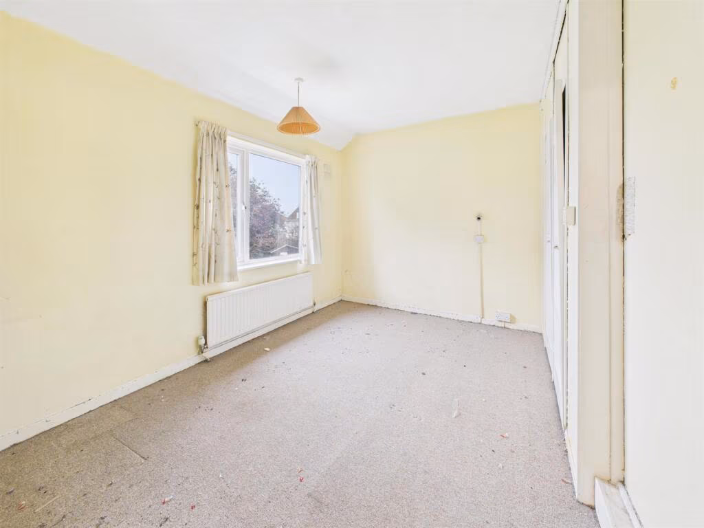
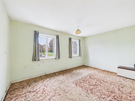
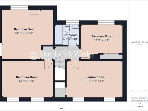
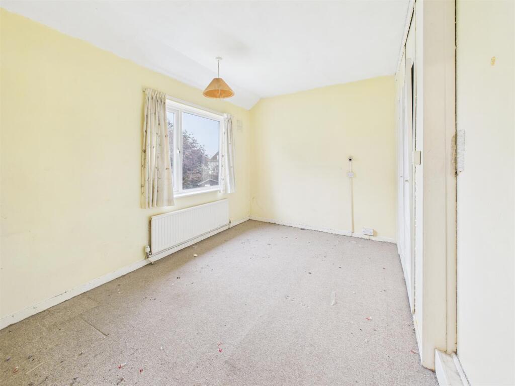
- Bedroom One:
- Bedroom Three:
- Bedroom Two:
- Bedroom Four:
- Bathroom:
Textual Property Features
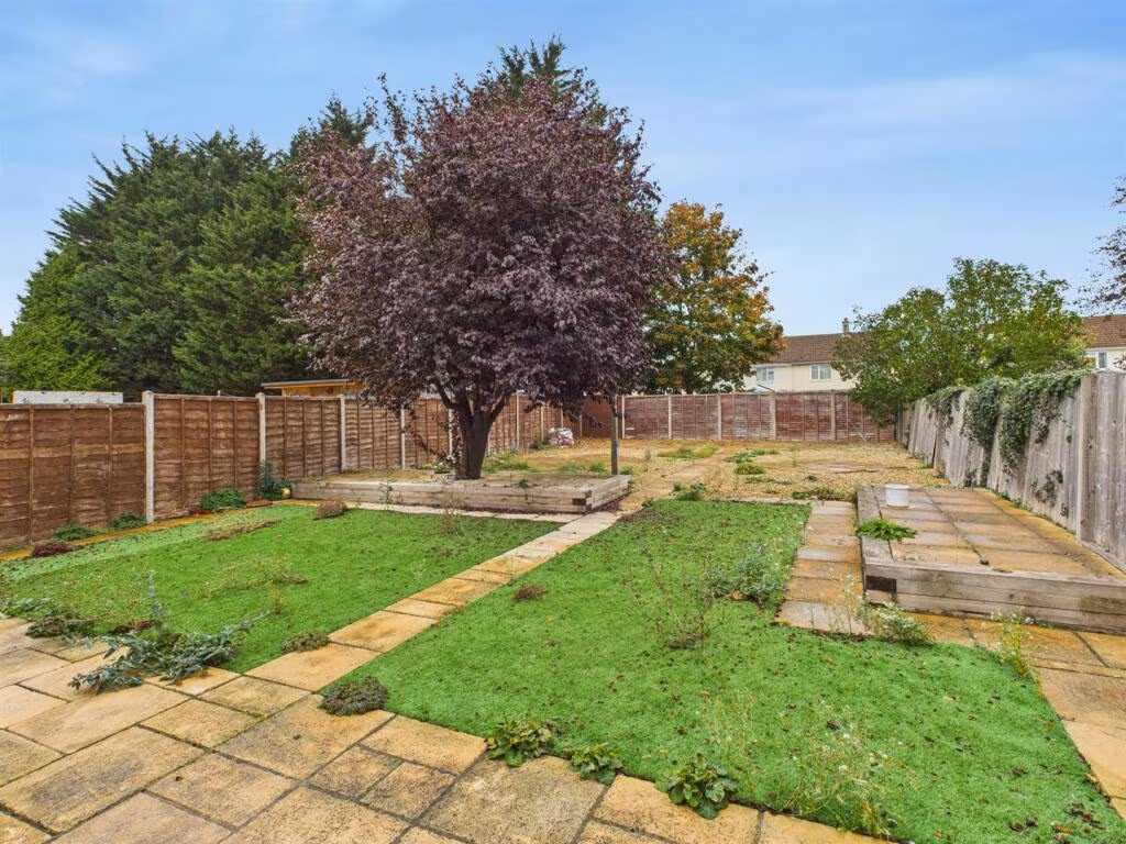
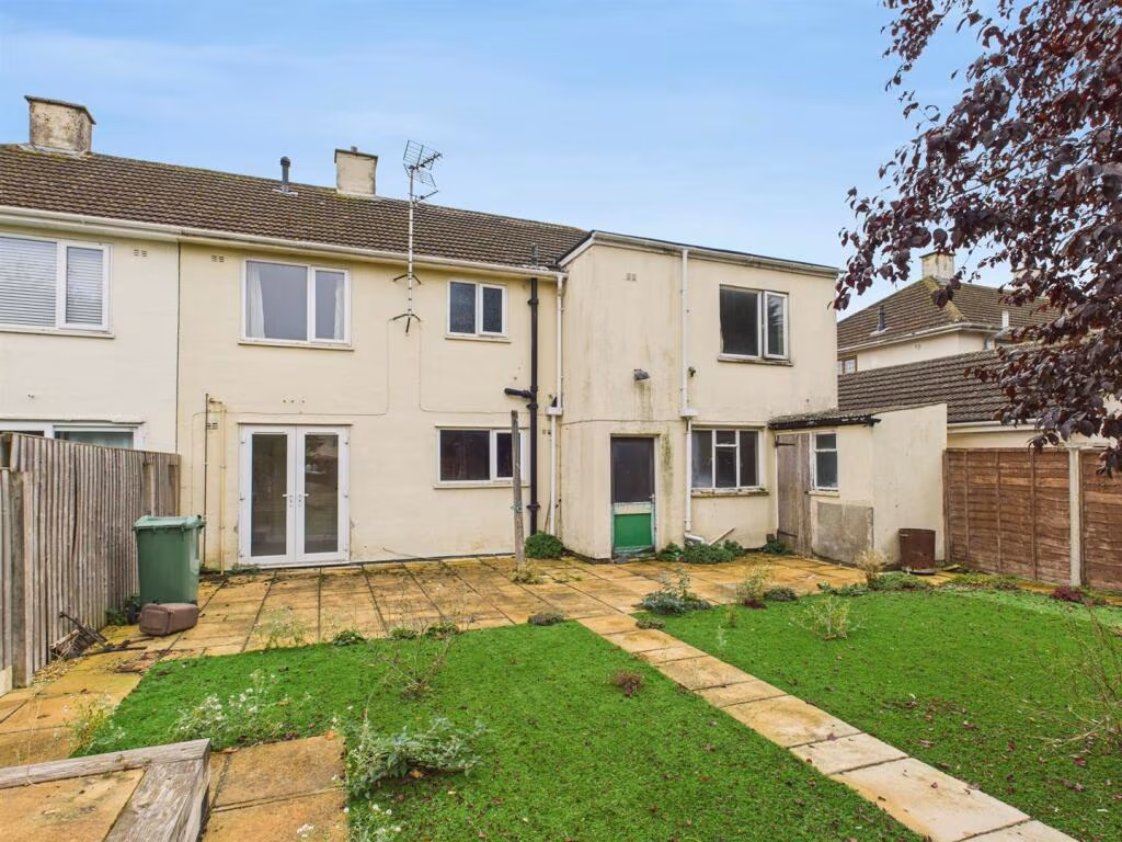
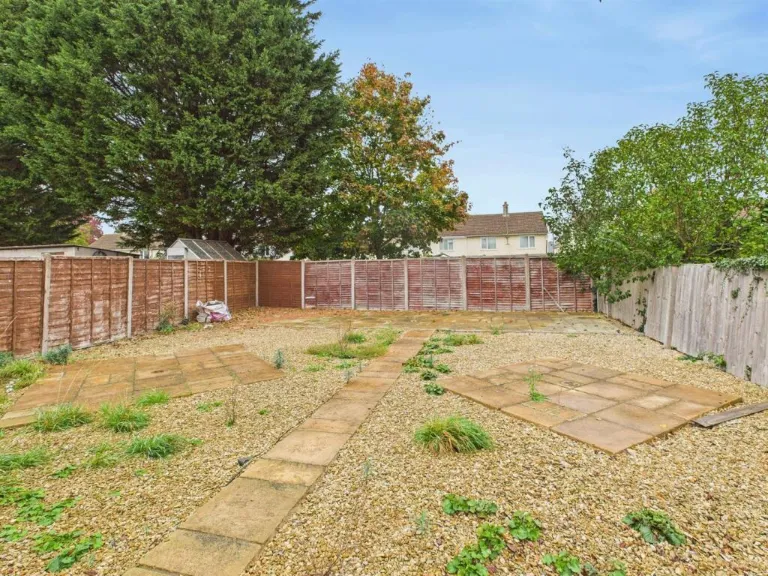
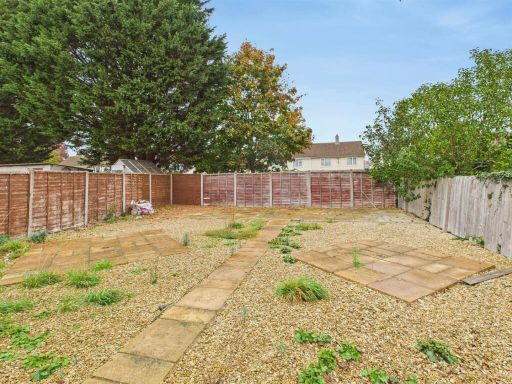
- Has Garden
- Chain Free
- Success
Detected Visual Features
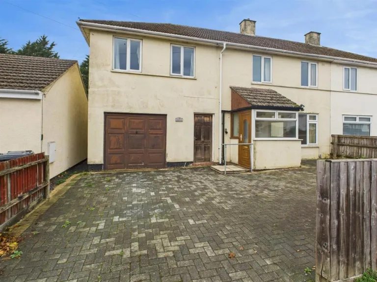
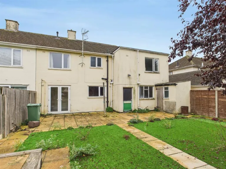
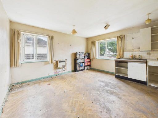
- semi-detached
- post-war
- garage
- garden
- paved driveway
- fixer-upper
- dated exterior
- needs maintenance
- investment opportunity
- kitchen
- 1970s
- 1980s
- renovation
- dated
- worn
EPC Details
- Fully double glazed
- System built, as built, no insulation (assumed)
- Boiler and radiators, mains gas
- Low energy lighting in all fixed outlets
- Solid, no insulation (assumed)
Nearby Schools
- Heron Primary School
- Dinglewell Infant School
- Barnwood Park School
- Barnwood Church of England Primary School
- Denmark Road High School
- Sir Thomas Rich's School
- Churchdown Parton Manor Junior School
- Gloucester Academy
- Abbeymead Primary School
- Al Ashraf Primary School
- Al-Ashraf Secondary School for Girls
- Widden Primary School
- St Peter's Catholic Primary School
- Innsworth Infant School
- Dinglewell Junior School
- Hillview Primary School
- Edward Jenner School
- Longlevens Junior School
- St Mary's Catholic Primary School
- Coney Hill Community Primary School
- Wotton House International School Gloucestershire
- Elmbridge Primary School
- Kingsholm Church of England Primary School
- Longlevens Infant School
- Longford Park Primary Academy
- Innsworth Junior School
- Churchdown Parton Manor Infant School
Nearest Bars And Restaurants
- Id: 1035390250
- Tags:
- Amenity: pub
- Building: yes
- Name: Walls Club
- TagsNormalized:
- Lat: 51.8649618
- Lon: -2.207308
- FullGeoHash: gcnrjc8xmcxu
- PartitionGeoHash: gcnr
- Images:
- FoodStandards: null
- Distance: 893.8
,- Id: 2733733770
- Tags:
- Amenity: fast_food
- Cuisine: fish_and_chips
- Source:
- TagsNormalized:
- Lat: 51.8735921
- Lon: -2.221322
- FullGeoHash: gcnrj7q3x6qm
- PartitionGeoHash: gcnr
- Images:
- FoodStandards: null
- Distance: 866
,- Id: 229218838
- Tags:
- Amenity: pub
- Building: yes
- Name: The Greyhound
- TagsNormalized:
- Lat: 51.8777953
- Lon: -2.2040846
- FullGeoHash: gcnrju5411gr
- PartitionGeoHash: gcnr
- Images:
- FoodStandards: null
- Distance: 626.8
,- Id: 26002252
- Tags:
- Amenity: pub
- Name: The Teddy
- Wheelchair: yes
- TagsNormalized:
- Lat: 51.8755045
- Lon: -2.2092263
- FullGeoHash: gcnrjexk9qcm
- PartitionGeoHash: gcnr
- Images:
- FoodStandards: null
- Distance: 285.9
,- Id: 10605332724
- Tags:
- Amenity: fast_food
- Name: Subway
- TagsNormalized:
- Lat: 51.8743416
- Lon: -2.2105642
- FullGeoHash: gcnrjeqmfn5u
- PartitionGeoHash: gcnr
- Images:
- FoodStandards: null
- Distance: 198.6
}
Nearest General Shops
- Id: 255046175
- Tags:
- Building: yes
- Name: Nick Brown's
- Shop: butcher
- TagsNormalized:
- Lat: 51.8781764
- Lon: -2.2172434
- FullGeoHash: gcnrjs1kq3p2
- PartitionGeoHash: gcnr
- Images:
- FoodStandards: null
- Distance: 823.2
,- Id: 255060410
- Tags:
- Addr:
- City: Gloucester
- Postcode: GL2 0JW
- Building: industrial
- Name: Pearman Briggs Leisure Ltd
- Note: Caravan showroom
- Shop: yes
- TagsNormalized:
- Lat: 51.8758444
- Lon: -2.2053223
- FullGeoHash: gcnrjgdnsq29
- PartitionGeoHash: gcnr
- Images:
- FoodStandards: null
- Distance: 398.7
,- Id: 10650377134
- Tags:
- TagsNormalized:
- Lat: 51.875785
- Lon: -2.2097487
- FullGeoHash: gcnrjewym55z
- PartitionGeoHash: gcnr
- Images:
- FoodStandards: null
- Distance: 322.6
}
Nearest Grocery shops
- Id: 268963607
- Tags:
- Building: yes
- Name: Walls factory company shop
- Shop: convenience
- TagsNormalized:
- Lat: 51.8665888
- Lon: -2.2020843
- FullGeoHash: gcnrjfh2z8yv
- PartitionGeoHash: gcnr
- Images:
- FoodStandards: null
- Distance: 842.5
,- Id: 230878776
- Tags:
- Brand: Tesco Express
- Brand:wikidata: Q98456772
- Building: retail
- Building:levels: 2
- Name: Tesco Express
- Opening_hours: Mo-Su 06:00-22:00
- Shop: convenience
- Wheelchair: yes
- TagsNormalized:
- tesco
- tesco express
- retail
- convenience
- shop
- Lat: 51.8746249
- Lon: -2.2103158
- FullGeoHash: gcnrjeqrxfvn
- PartitionGeoHash: gcnr
- Images:
- FoodStandards: null
- Distance: 215
,- Id: 230878779
- Tags:
- Addr:
- Brand: Londis
- Brand:wikidata: Q21008564
- Building: retail
- Building:levels: 1
- Name: Londis
- Shop: convenience
- TagsNormalized:
- londis
- retail
- convenience
- shop
- Lat: 51.8743656
- Lon: -2.2106004
- FullGeoHash: gcnrjeqq168u
- PartitionGeoHash: gcnr
- Images:
- FoodStandards: null
- Distance: 202.3
}
Nearest Supermarkets
- Id: 235216984
- Tags:
- Alt_name: Morrisons Gloucester
- Brand: Morrisons
- Brand:wikidata: Q922344
- Brand:wikipedia: en:Morrisons
- Building: yes
- Contact:
- Website: https://my.morrisons.com/storefinder/575
- Loc_name: Morrisons Metz Way
- Name: Morrisons
- Operator: Morrisons
- Shop: supermarket
- TagsNormalized:
- Lat: 51.8607322
- Lon: -2.2223951
- FullGeoHash: gcnrj2vwwmnj
- PartitionGeoHash: gcnr
- Images:
- FoodStandards: null
- Distance: 1650.3
,- Id: 53322220
- Tags:
- Addr:
- City: Gloucester
- Postcode: GL4 3RT
- Street: Barnett Way
- Brand: Sainsbury's
- Brand:wikidata: Q152096
- Brand:wikipedia: en:Sainsbury's
- Building: commercial
- Name: Sainsbury's
- Operator: Sainsbury's
- Shop: supermarket
- TagsNormalized:
- sainsburys
- supermarket
- shop
- Lat: 51.8651462
- Lon: -2.2006589
- FullGeoHash: gcnrjcv82ujb
- PartitionGeoHash: gcnr
- Images:
- FoodStandards: null
- Distance: 1030.4
,- Id: 230878780
- Tags:
- Addr:
- Brand: Co-op Food
- Brand:wikidata: Q3277439
- Building: retail
- Building:levels: 1
- Name: Co-op Food
- Opening_hours: Su 10:00-16:00; Mo-Sa 07:00-21:00
- Operator: Co-op
- Shop: supermarket
- Wheelchair: yes
- TagsNormalized:
- co-op
- co-op food
- food
- retail
- supermarket
- shop
- Lat: 51.8738286
- Lon: -2.2123796
- FullGeoHash: gcnrjekfzyd0
- PartitionGeoHash: gcnr
- Images:
- FoodStandards: null
- Distance: 267.6
}
Nearest Religious buildings
- Id: 697402182
- Tags:
- Amenity: place_of_worship
- Denomination: methodist
- Name: Lonsdale Road Methodist Church
- Religion: christian
- Source: OS OpenData StreetView
- Source:name: Church website
- Url: http://www.lonsdaleroad.org.uk/
- TagsNormalized:
- place of worship
- methodist
- church
- christian
- Lat: 51.8676862
- Lon: -2.2171944
- FullGeoHash: gcnrjd1rptkp
- PartitionGeoHash: gcnr
- Images:
- FoodStandards: null
- Distance: 823.8
,- Id: 268402933
- Tags:
- Amenity: place_of_worship
- Building: church
- Denomination: baptist
- Name: Kendal Road Baptist Church
- Religion: christian
- Source: survey
- Wheelchair: limited
- TagsNormalized:
- place of worship
- church
- baptist
- christian
- Lat: 51.8742156
- Lon: -2.2166676
- FullGeoHash: gcnrje3v5ysv
- PartitionGeoHash: gcnr
- Images:
- FoodStandards: null
- Distance: 561.4
,- Id: 270556610
- Tags:
- Amenity: place_of_worship
- Building: church
- Denomination: anglican
- Name: Holy Trinity
- Religion: christian
- Source: OS OpenData StreetView
- Source:name: Personal knowledge
- Wheelchair: yes
- Wikidata: Q26676741
- TagsNormalized:
- place of worship
- church
- anglican
- christian
- Lat: 51.8753273
- Lon: -2.2105735
- FullGeoHash: gcnrjew79vuu
- PartitionGeoHash: gcnr
- Images:
- FoodStandards: null
- Distance: 292.5
}
Nearest Medical buildings
- Id: 30851505
- Tags:
- Amenity: hospital
- Emergency: yes
- Healthcare: hospital
- Name: Gloucestershire Royal Hospital
- Wikidata: Q1532247
- TagsNormalized:
- Lat: 51.8660903
- Lon: -2.2324907
- FullGeoHash: gcnrj1ymghn2
- PartitionGeoHash: gcnr
- Images:
- FoodStandards: null
- Distance: 1799.6
,- Id: 2888390864
- Tags:
- Addr:
- City: Gloucester
- Housename: Gloucestershire Royal Hospital
- Postcode: GL1 3NN
- Street: Great Western Road
- Amenity: hospital
- Emergency: yes
- Healthcare: hospital
- Healthcare:speciality: emergency
- Name: Gloucestershire Royal Hospital/A&E
- Operator: NHS
- Operator:type: public
- Phone: +44 300 4222 222
- TagsNormalized:
- hospital
- health
- healthcare
- emergency
- Lat: 51.8663703
- Lon: -2.2319738
- FullGeoHash: gcnrj1yxx0pw
- PartitionGeoHash: gcnr
- Images:
- FoodStandards: null
- Distance: 1754.3
,- Id: 1143735976
- Tags:
- Amenity: clinic
- Building: hospital
- Description: Gloucester Royal Hospital dermatology department
- Name: Aspen Centre
- TagsNormalized:
- Lat: 51.864959
- Lon: -2.2265264
- FullGeoHash: gcnrj3dxq1je
- PartitionGeoHash: gcnr
- Images:
- FoodStandards: null
- Distance: 1509.7
,- Id: 59013169
- Tags:
- Addr:
- City: Gloucester
- Postcode: GL4 3HR
- Brand: Nuffield Health Fitness & Wellbeing
- Brand:wikidata: Q7068711
- Building: yes
- Leisure: fitness_centre
- Name: Nuffield Health Fitness & Wellbeing
- Roof:
- TagsNormalized:
- fitness
- health
- nuffield
- nuffield health fitness & wellbeing
- fitness centre
- leisure
- Lat: 51.8673223
- Lon: -2.1971545
- FullGeoHash: gcnrn40j49dv
- PartitionGeoHash: gcnr
- Images:
- FoodStandards: null
- Distance: 1012.6
}
Nearest Leisure Facilities
- Id: 389552570
- Tags:
- Leisure: pitch
- Sport: bowls
- TagsNormalized:
- Lat: 51.8728911
- Lon: -2.2049901
- FullGeoHash: gcnrjg4mkpb0
- PartitionGeoHash: gcnr
- Images:
- FoodStandards: null
- Distance: 258.2
,- Id: 389976588
- Tags:
- Building: yes
- Leisure: swimming_pool
- Name: Swimming Pool
- TagsNormalized:
- swimming
- swimming pool
- pool
- leisure
- Lat: 51.8727773
- Lon: -2.205392
- FullGeoHash: gcnrjg4hfds9
- PartitionGeoHash: gcnr
- Images:
- FoodStandards: null
- Distance: 231.4
,- Id: 229338410
- Tags:
- TagsNormalized:
- Lat: 51.8719204
- Lon: -2.2059147
- FullGeoHash: gcnrjfcxy6yc
- PartitionGeoHash: gcnr
- Images:
- FoodStandards: null
- Distance: 225.9
,- Id: 229338851
- Tags:
- TagsNormalized:
- Lat: 51.8716549
- Lon: -2.2083693
- FullGeoHash: gcnrjdzym326
- PartitionGeoHash: gcnr
- Images:
- FoodStandards: null
- Distance: 146.4
,- Id: 229338850
- Tags:
- TagsNormalized:
- Lat: 51.8720886
- Lon: -2.2085935
- FullGeoHash: gcnrjepbb41m
- PartitionGeoHash: gcnr
- Images:
- FoodStandards: null
- Distance: 96.4
}
Nearest Tourist attractions
- Id: 1034092125
- Tags:
- Addr:
- City: Gloucester
- Street: Brunswick Road
- Building: yes
- Fee: no
- Name: Museum of Gloucester
- Tourism: museum
- Wikidata: Q5572022
- TagsNormalized:
- Lat: 51.8634042
- Lon: -2.244594
- FullGeoHash: gcnrhcmw1pm2
- PartitionGeoHash: gcnr
- Images:
- FoodStandards: null
- Distance: 2680.2
,- Id: 322166945
- Tags:
- Description: Roman Remains
- Historic: citywalls
- Name: Gloucester City Wall
- Tourism: attraction
- TagsNormalized:
- Lat: 51.8640293
- Lon: -2.2438133
- FullGeoHash: gcnrhcw1g7g9
- PartitionGeoHash: gcnr
- Images:
- FoodStandards: null
- Distance: 2603.7
,- Id: 365284652
- Tags:
- Addr:
- City: Gloucester
- Housenumber: 23
- Postcode: GL1 4NG
- Street: Albany Street
- Name: Saint James City Farm
- Phone: +44 1452 305728
- Tourism: attraction
- Website: www.stjamescityfarm.co.uk
- TagsNormalized:
- Lat: 51.8560918
- Lon: -2.2338261
- FullGeoHash: gcnrj0j7sh4s
- PartitionGeoHash: gcnr
- Images:
- FoodStandards: null
- Distance: 2545.3
}
Nearest Train stations
- Id: 1592883651
- Tags:
- Name: Gotherington
- Naptan:
- Operator: Gloucestershire and Warwickshire Steam Railway
- Public_transport: station
- Railway: station
- Source: Bing;local_knowledge
- Usage: tourism
- Wikidata: Q5587849
- TagsNormalized:
- Lat: 51.9672114
- Lon: -2.0380294
- FullGeoHash: gcnx9s7fyqr4
- PartitionGeoHash: gcnx
- Images:
- FoodStandards: null
- Distance: 15714.3
,- Id: 5520072621
- Tags:
- Name: Ashchurch
- Naptan:
- Network: National Rail
- Public_transport: station
- Railway: station
- Ref:
- Source: NPE
- Wikipedia: en:Ashchurch for Tewkesbury railway station
- TagsNormalized:
- Lat: 51.9990255
- Lon: -2.1087299
- FullGeoHash: gcnxb40kr0cj
- PartitionGeoHash: gcnx
- Images:
- FoodStandards: null
- Distance: 15606.1
,- Id: 15825263
- Tags:
- Name: Cheltenham Racecourse
- Naptan:
- Operator: Gloucestershire and Warwickshire Steam Railway
- Public_transport: station
- Railway: station
- Source: npe
- Usage: tourism
- Wikidata: Q5090223
- Wikipedia: en:Cheltenham Racecourse railway station
- TagsNormalized:
- Lat: 51.9243306
- Lon: -2.0678139
- FullGeoHash: gcnx2uw30ky0
- PartitionGeoHash: gcnx
- Images:
- FoodStandards: null
- Distance: 11231.8
,- Id: 7154294070
- Tags:
- Addr:
- City: Cheltenham
- Postcode: GL51 8NP
- Street: Queens Road
- Name: Cheltenham Spa
- Naptan:
- Network: National Rail
- Old_name: Cheltenham Spa (Lansdown)
- Operator: First Great Western
- Public_transport: station
- Railway: station
- Ref:
- Source: Bing
- Wheelchair: yes
- Wikipedia: en:Cheltenham Spa railway station
- TagsNormalized:
- Lat: 51.8969882
- Lon: -2.1001222
- FullGeoHash: gcnx0pw9zeg3
- PartitionGeoHash: gcnx
- Images:
- FoodStandards: null
- Distance: 7920.3
,- Id: 6646199707
- Tags:
- Name: Gloucester
- Naptan:
- Network: National Rail
- Operator: Great Western Railway
- Postal_code: GL1 1DE
- Public_transport: station
- Railway: station
- Ref:
- Wheelchair: yes
- Wikipedia: en:Gloucester railway station
- TagsNormalized:
- Lat: 51.8655109
- Lon: -2.2382438
- FullGeoHash: gcnrj1f4mpur
- PartitionGeoHash: gcnr
- Images:
- FoodStandards: null
- Distance: 2187.4
}
Nearest Hotels
- Id: 59011640
- Tags:
- Addr:
- City: Gloucester
- Postcode: GL4 3RX
- Brand: Holiday Inn
- Brand:wikidata: Q2717882
- Brand:wikipedia: en:Holiday Inn
- Building: yes
- Name: Holiday Inn Barnwood
- Source: OS_OpenData_StreetView & Local Knowledge
- Tourism: hotel
- TagsNormalized:
- Lat: 51.8640867
- Lon: -2.1937898
- FullGeoHash: gcnrn1dd0yxb
- PartitionGeoHash: gcnr
- Images:
- FoodStandards: null
- Distance: 1423.5
,- Id: 144934840
- Tags:
- Addr:
- City: Gloucester
- Parentstreet: Corinium Avenue
- Postcode: GL4 3DG
- Street: Sawmills End
- Brand: Ibis
- Brand:wikidata: Q920166
- Building: hotel
- Name: Ibis Gloucester
- Source: survey
- Tourism: hotel
- Website: http://www.ibis.com/gb/hotel-6900-ibis-gloucester/
- TagsNormalized:
- Lat: 51.8648468
- Lon: -2.211067
- FullGeoHash: gcnrj9tywkhy
- PartitionGeoHash: gcnr
- Images:
- FoodStandards: null
- Distance: 915
,- Id: 59013170
- Tags:
- Brand: Premier Inn
- Brand:wikidata: Q2108626
- Brand:wikipedia: en:Premier Inn
- Building: yes
- Internet_access: wlan
- Internet_access:fee: customers
- Internet_access:operator: Virgin Media
- Internet_access:ssid: Premier Inn Free Wi-Fi
- Name: Premier Inn
- Tourism: hotel
- TagsNormalized:
- Lat: 51.8690849
- Lon: -2.1976427
- FullGeoHash: gcnrjfrxr4nz
- PartitionGeoHash: gcnr
- Images:
- FoodStandards: null
- Distance: 875.4
}
Tags
- semi-detached
- post-war
- garage
- garden
- paved driveway
- fixer-upper
- dated exterior
- needs maintenance
- investment opportunity
- kitchen
- 1970s
- 1980s
- renovation
- dated
- worn
Local Market Stats
- Average Price/sqft: £299
- Avg Income: £51900
- Rental Yield: 4.4%
- Social Housing: 6%
- Planning Success Rate: 79%
AirBnB Data
- 1km average: £139/night
- Listings in 1km: 1
Similar Properties
 3 bedroom semi-detached house for sale in Wellsprings Road, Longlevens, Gloucester, GL2 — £340,000 • 3 bed • 1 bath • 896 ft²
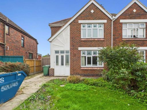 3 bedroom semi-detached house for sale in Cheltenham Road, Longlevens, Gloucester, GL2 — £315,000 • 3 bed • 2 bath • 1011 ft²
 3 bedroom semi-detached house for sale in Argyll Road, Longlevens, Gloucester, GL2 — £350,000 • 3 bed • 1 bath • 1551 ft²
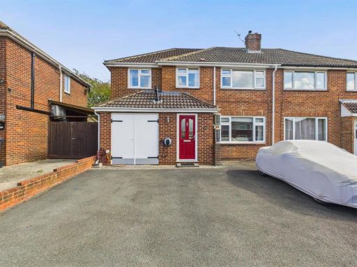 4 bedroom semi-detached house for sale in Lavington Drive, Longlevens, Gloucester, GL2 — £405,000 • 4 bed • 2 bath • 1186 ft²
 3 bedroom semi-detached house for sale in Cheltenham Road, Longlevens, Gloucester, GL2 — £325,000 • 3 bed • 1 bath • 901 ft²
 3 bedroom detached house for sale in Sivell Close, Longford, Gloucester, GL2 — £325,000 • 3 bed • 2 bath • 916 ft²
Meta
- {
"@context": "https://schema.org",
"@type": "Residence",
"name": "4 bedroom semidetached house for sale in Oakleaze, Longleve…",
"description": "",
"url": "https://propertypiper.co.uk/property/eb930f79-3264-4ba0-964c-41714de6ddb5",
"image": "https://image-a.propertypiper.co.uk/4a834cd8-13a2-4fbc-9e12-e878af0d4db2-1024.jpeg",
"address": {
"@type": "PostalAddress",
"streetAddress": "Oakleaze, Longlevens, Gloucester",
"postalCode": "GL2 0LG",
"addressLocality": "Gloucester",
"addressRegion": "Gloucester",
"addressCountry": "England"
},
"geo": {
"@type": "GeoCoordinates",
"latitude": 51.87295002913086,
"longitude": -2.2087504233011828
},
"numberOfRooms": 4,
"numberOfBathroomsTotal": 1,
"floorSize": {
"@type": "QuantitativeValue",
"value": 1155,
"unitCode": "FTK"
},
"offers": {
"@type": "Offer",
"price": 275000,
"priceCurrency": "GBP",
"availability": "https://schema.org/InStock"
},
"additionalProperty": [
{
"@type": "PropertyValue",
"name": "Feature",
"value": "semi-detached"
},
{
"@type": "PropertyValue",
"name": "Feature",
"value": "post-war"
},
{
"@type": "PropertyValue",
"name": "Feature",
"value": "garage"
},
{
"@type": "PropertyValue",
"name": "Feature",
"value": "garden"
},
{
"@type": "PropertyValue",
"name": "Feature",
"value": "paved driveway"
},
{
"@type": "PropertyValue",
"name": "Feature",
"value": "fixer-upper"
},
{
"@type": "PropertyValue",
"name": "Feature",
"value": "dated exterior"
},
{
"@type": "PropertyValue",
"name": "Feature",
"value": "needs maintenance"
},
{
"@type": "PropertyValue",
"name": "Feature",
"value": "investment opportunity"
},
{
"@type": "PropertyValue",
"name": "Feature",
"value": "kitchen"
},
{
"@type": "PropertyValue",
"name": "Feature",
"value": "1970s"
},
{
"@type": "PropertyValue",
"name": "Feature",
"value": "1980s"
},
{
"@type": "PropertyValue",
"name": "Feature",
"value": "renovation"
},
{
"@type": "PropertyValue",
"name": "Feature",
"value": "dated"
},
{
"@type": "PropertyValue",
"name": "Feature",
"value": "worn"
}
]
}
High Res Floorplan Images
Compatible Floorplan Images
FloorplanImages Thumbnail