GL2 0NL - 3 bedroom semidetached house for sale in Wellsprings Road,…
View on Property Piper
3 bedroom semi-detached house for sale in Wellsprings Road, Longlevens, Gloucester, GL2
Property Details
- Price: £340000
- Bedrooms: 3
- Bathrooms: 1
- Property Type: undefined
- Property SubType: undefined
Brochure Descriptions
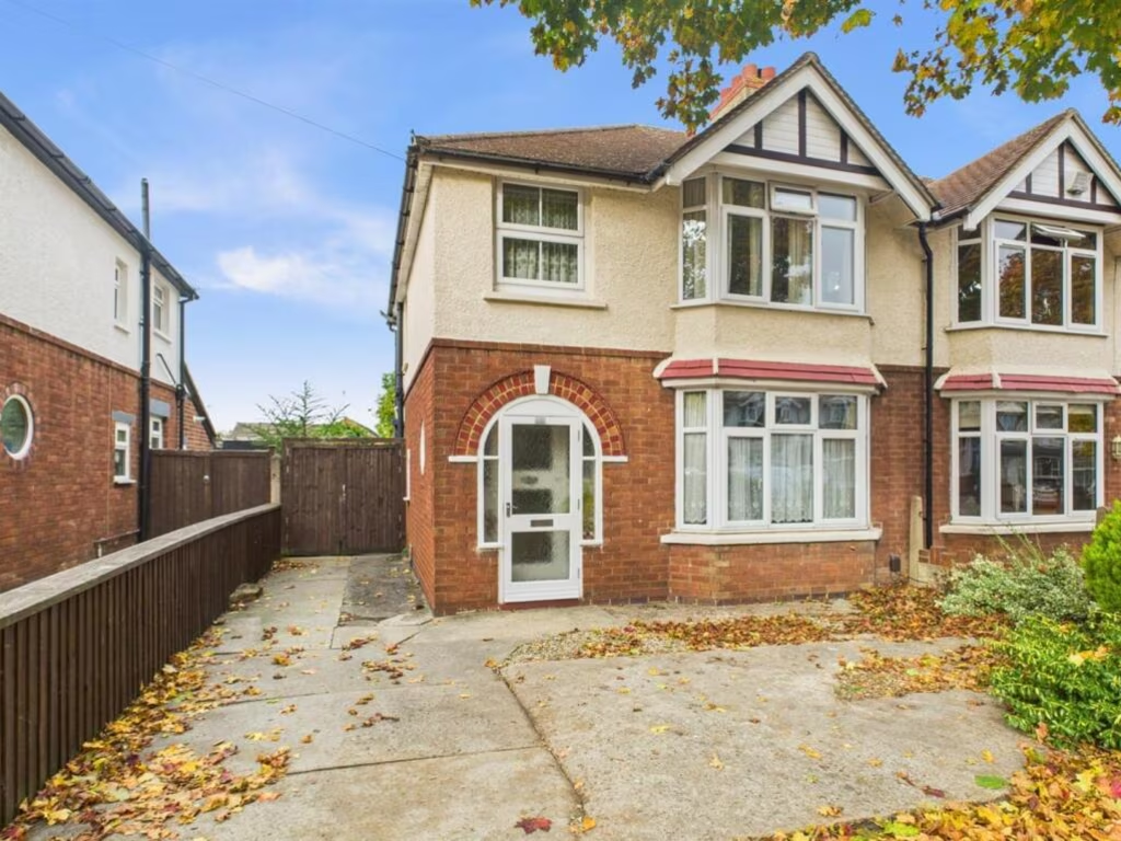
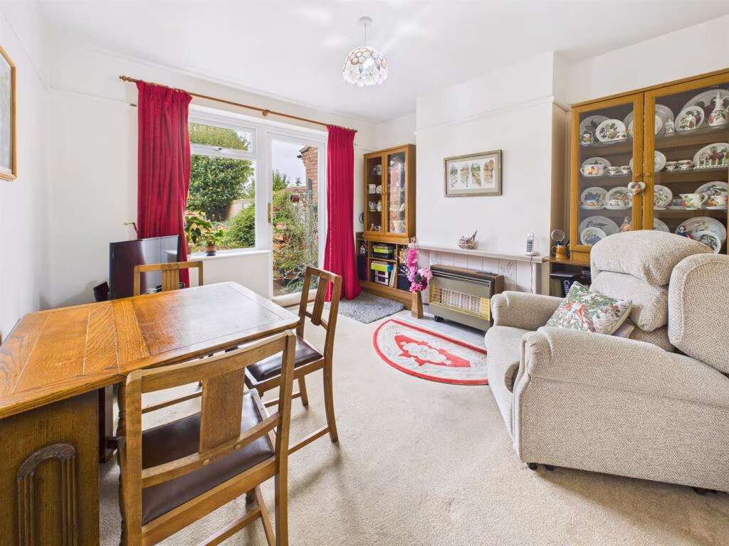
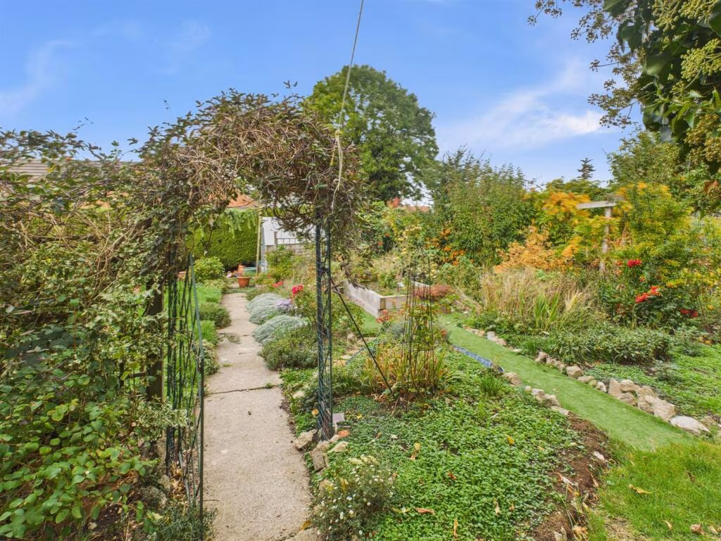
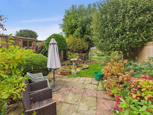
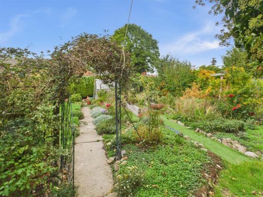
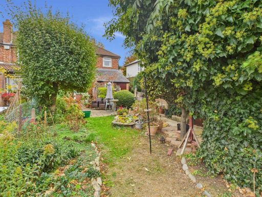
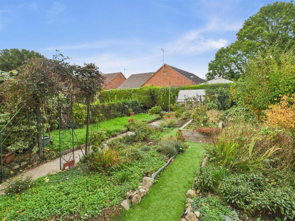
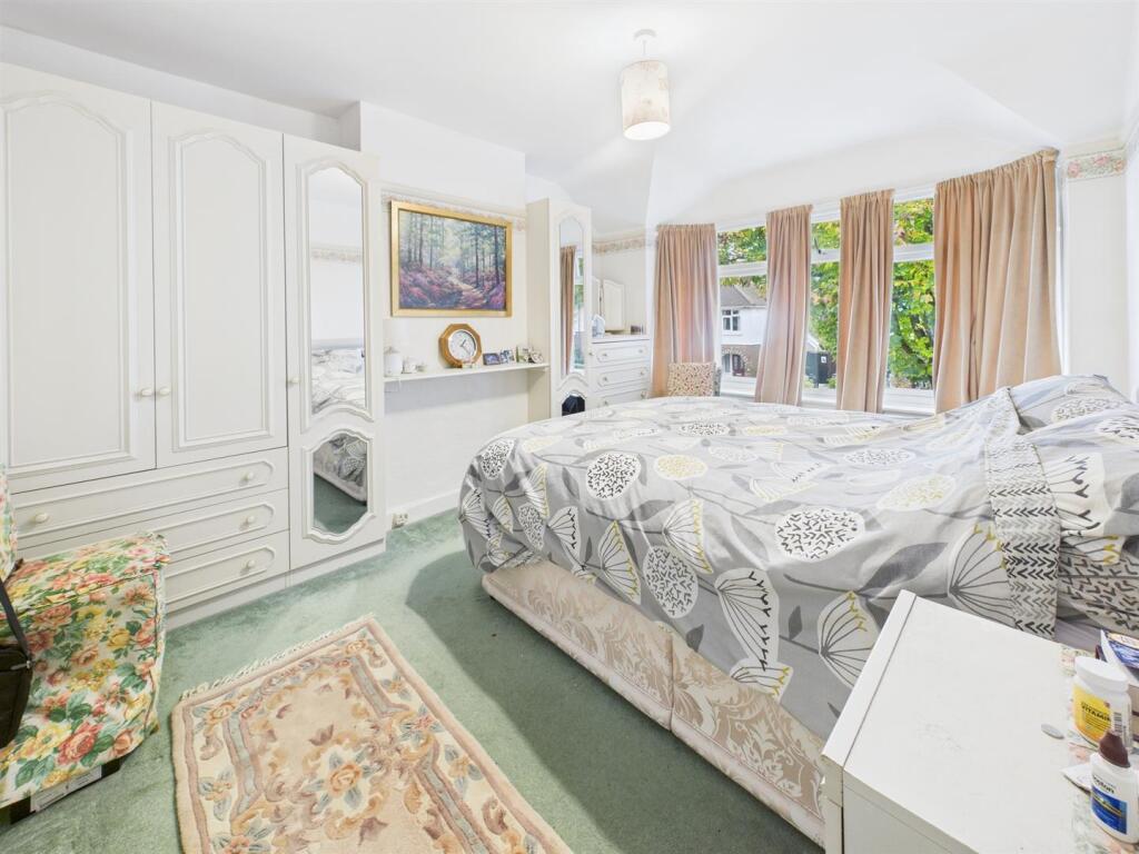
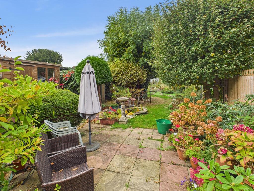
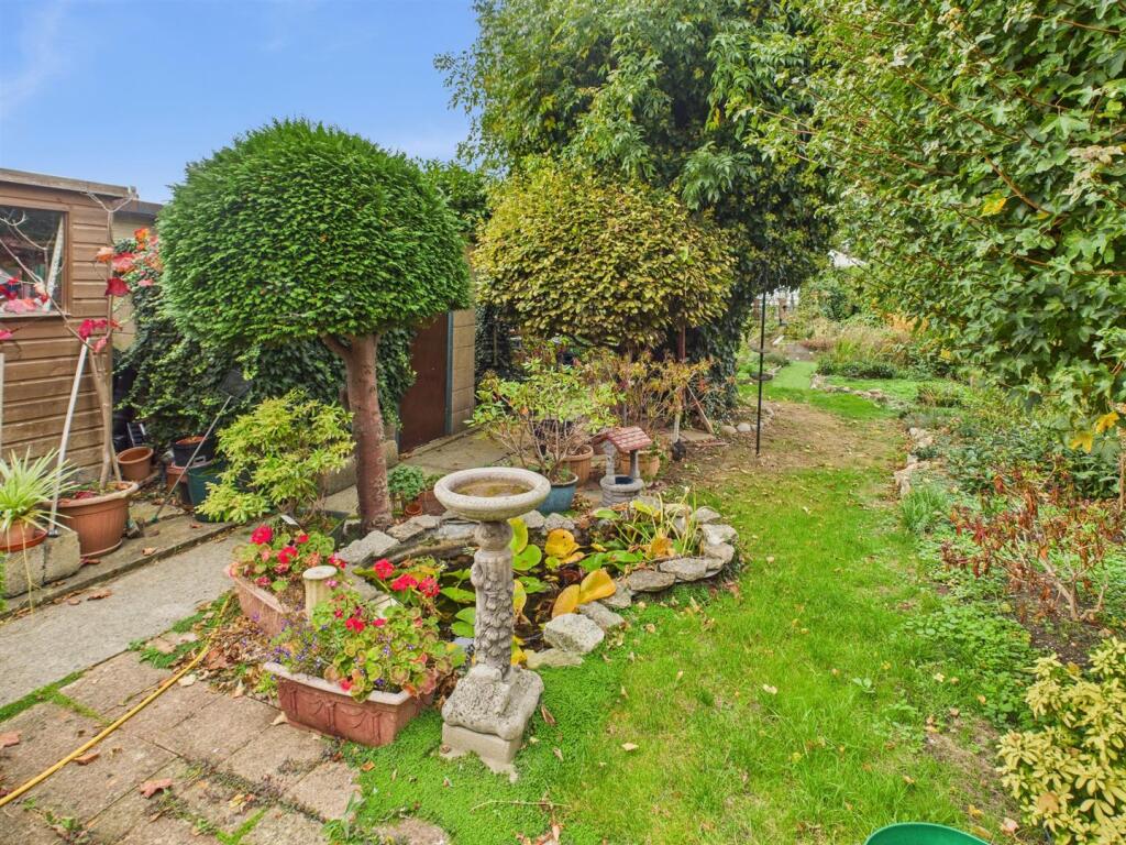
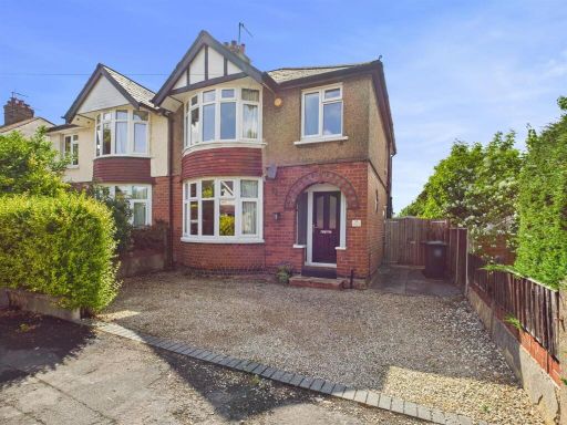
- Semi‑detached, traditional bay‑front family home offered for sale. Circa early‑20th century style with rendered upper facade and brick lower elevation, pitched tiled roof and front bay window. Internally shown as providing three bedrooms, one bathroom and two reception rooms. Property sits on a substantial plot with a driveway providing off‑street parking, gated side access and a large rear garden with mature planting — garden size: large. Overall property footprint: medium (typical three‑bed family dwelling) with generous plot depth. Condition: habitable but requiring some general modernisation and updating; presents good potential to extend/modernise subject to consents. Views: suburban residential outlook to front and private garden aspect to rear. Good presentation for long‑term owner occupation or refurbishment to add value.
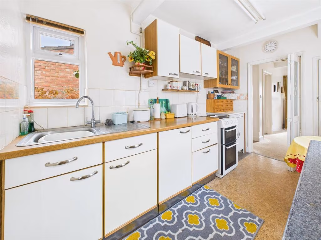
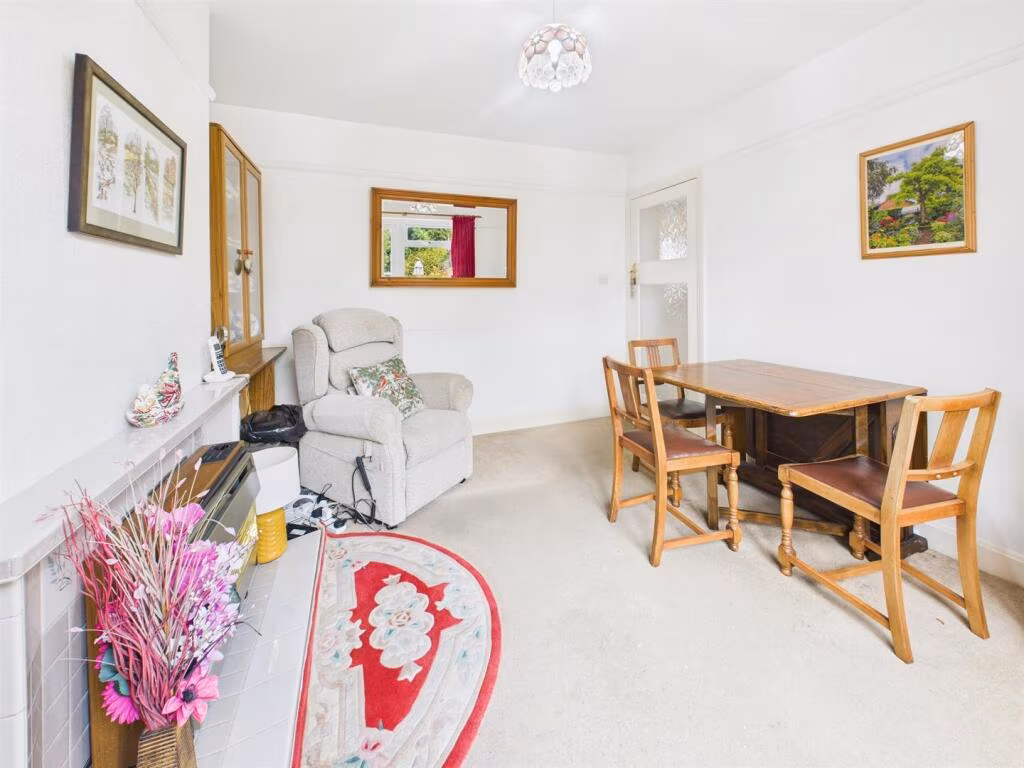
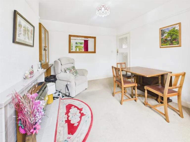
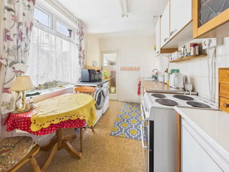
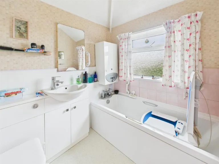
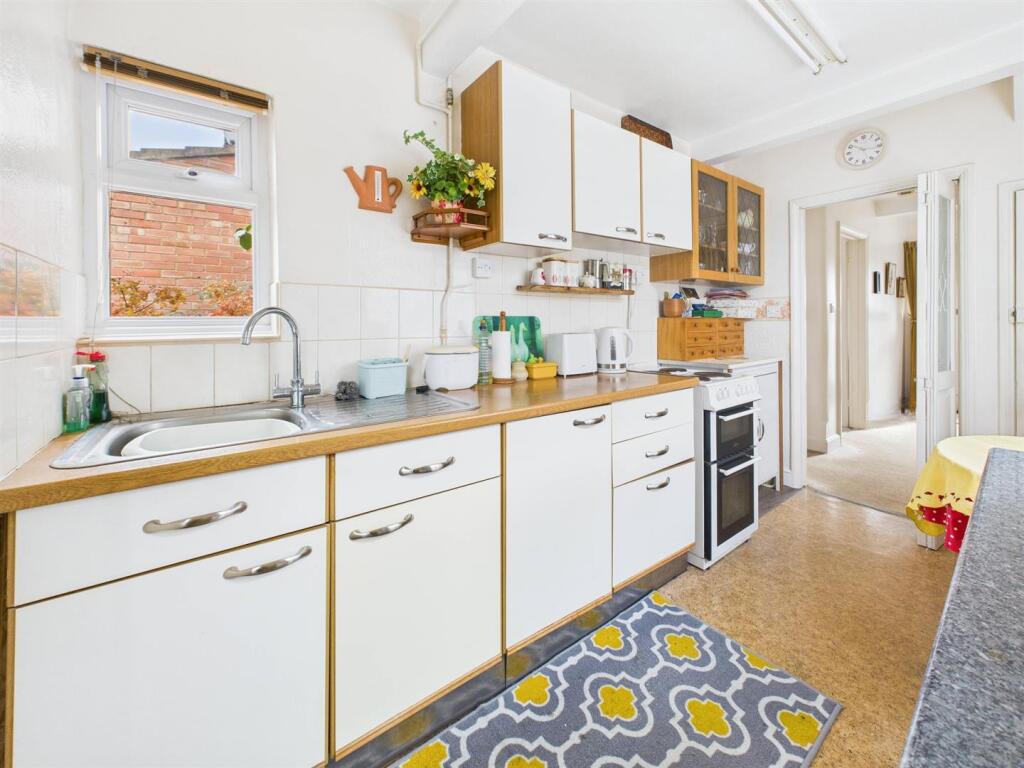
- Mid-era two-storey residential dwelling arranged with ground floor lounge, separate dining room, kitchen, rear lobby and cloakroom/WC; first floor landing serving three bedrooms and a family bathroom. The accommodation suggests a mid-terrace or semi-terraced layout with conventional room proportions (bedrooms and reception rooms of average size). Rear garden described as large, partly paved but mainly laid to lawn with flower/shrub borders and a greenhouse. Property is offered freehold. Services noted as mains water, electricity, gas and drainage. Local authority: Gloucester City Council (Band C). Overall impression for a valuer: a standard three-bedroom family home of average internal living space with a larger-than-typical rear garden, likely appealing to first-time buyers or families looking for outside space; refurbishment/decoration state not specified from images.
Image Descriptions
- semi-detached house early to mid-20th century
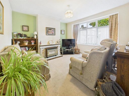
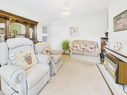
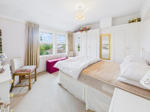
- living room mid-20th century
Floorplan Description
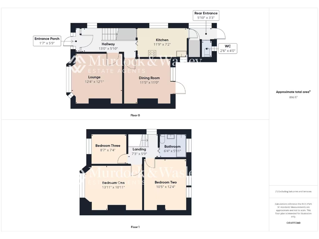
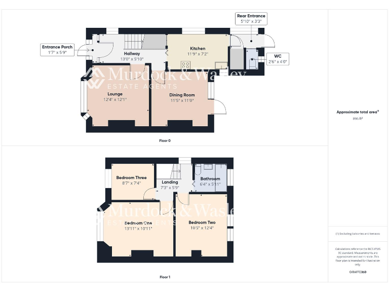
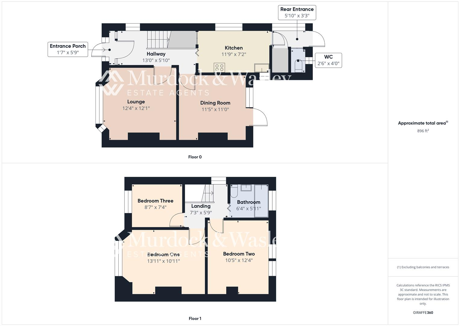
- Two-storey residential property with lounge, dining room, kitchen and three bedrooms
Rooms
- Entrance Porch:
- Hallway:
- Lounge:
- Dining Room:
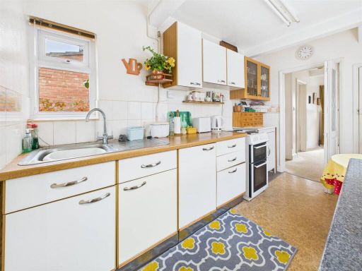
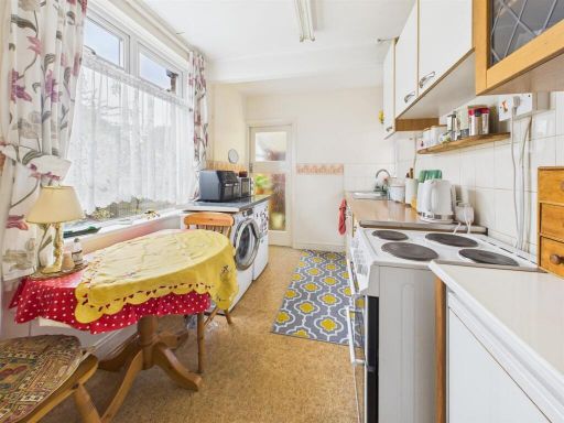
- Kitchen:
- Rear Entrance:
- WC:
- Bedroom Three:
- Landing:
- Bathroom:
- Bedroom One:
- Bedroom Two:
Textual Property Features
- Has Garden
- Probate Detected
- Chain Free
- Success
Detected Visual Features
- semi-detached
- early 20th century
- two-storey
- front bay window
- exposed brick
- off-road parking
- fixer-upper
- needs modernization
- mid-20th century
- living room
- standard ceiling
- gas fireplace
- wallpaper
- large window
- dated decor
- medium size
- potential to update
Nearby Schools
- Heron Primary School
- Dinglewell Infant School
- Barnwood Park School
- Barnwood Church of England Primary School
- Denmark Road High School
- Sir Thomas Rich's School
- Gloucester Academy
- Finlay Community School
- Tredworth Infant and Nursery Academy
- Al Ashraf Primary School
- Al-Ashraf Secondary School for Girls
- Widden Primary School
- St Peter's Catholic Primary School
- Innsworth Infant School
- Tredworth Junior School
- Dinglewell Junior School
- Edward Jenner School
- The King's School, Gloucester
- Longlevens Junior School
- St Mary's Catholic Primary School
- Coney Hill Community Primary School
- Wotton House International School Gloucestershire
- Elmbridge Primary School
- Kingsholm Church of England Primary School
- Longlevens Infant School
- Longford Park Primary Academy
- Innsworth Junior School
Nearest Bars And Restaurants
- Id: 26342015
- Tags:
- Amenity: fast_food
- Cuisine: fish_and_chips
- Name: Queen's
- TagsNormalized:
- Lat: 51.8655269
- Lon: -2.2169091
- FullGeoHash: gcnrj9cdw6bz
- PartitionGeoHash: gcnr
- Images:
- FoodStandards: null
- Distance: 876.5
,- Id: 26002252
- Tags:
- Amenity: pub
- Name: The Teddy
- Wheelchair: yes
- TagsNormalized:
- Lat: 51.8755045
- Lon: -2.2092263
- FullGeoHash: gcnrjexk9qcm
- PartitionGeoHash: gcnr
- Images:
- FoodStandards: null
- Distance: 734.4
,- Id: 10605332724
- Tags:
- Amenity: fast_food
- Name: Subway
- TagsNormalized:
- Lat: 51.8743416
- Lon: -2.2105642
- FullGeoHash: gcnrjeqmfn5u
- PartitionGeoHash: gcnr
- Images:
- FoodStandards: null
- Distance: 611
,- Id: 415502743
- Tags:
- Amenity: pub
- Name: Glevum Inn
- TagsNormalized:
- Lat: 51.8765493
- Lon: -2.2238522
- FullGeoHash: gcnrj7udu3xw
- PartitionGeoHash: gcnr
- Images:
- FoodStandards: null
- Distance: 480.5
,- Id: 2733733770
- Tags:
- Amenity: fast_food
- Cuisine: fish_and_chips
- Source:
- TagsNormalized:
- Lat: 51.8735921
- Lon: -2.221322
- FullGeoHash: gcnrj7q3x6qm
- PartitionGeoHash: gcnr
- Images:
- FoodStandards: null
- Distance: 143.8
}
Nearest General Shops
- Id: 255046176
- Tags:
- Building: yes
- Shop: newsagent
- TagsNormalized:
- Lat: 51.8782518
- Lon: -2.2171875
- FullGeoHash: gcnrjs1kxz14
- PartitionGeoHash: gcnr
- Images:
- FoodStandards: null
- Distance: 572.4
,- Id: 255046175
- Tags:
- Building: yes
- Name: Nick Brown's
- Shop: butcher
- TagsNormalized:
- Lat: 51.8781764
- Lon: -2.2172434
- FullGeoHash: gcnrjs1kq3p2
- PartitionGeoHash: gcnr
- Images:
- FoodStandards: null
- Distance: 563.3
,- Id: 268407841
- Tags:
- Building: yes
- Name: Oxstalls
- Shop: car
- Source: survey
- TagsNormalized:
- Lat: 51.8731642
- Lon: -2.2217448
- FullGeoHash: gcnrj7npjdej
- PartitionGeoHash: gcnr
- Images:
- FoodStandards: null
- Distance: 168.7
}
Nearest Grocery shops
- Id: 1250571172
- Tags:
- Brand: M&S Simply Food
- Brand:wikidata: Q714491
- Brand:wikipedia: en:Marks & Spencer
- Contact:
- Website: https://www.marksandspencer.com/stores/barnwood-bp-1227
- Name: M&S Simply Food
- Operator: M&S
- Shop: convenience
- Source: local knowldege
- TagsNormalized:
- m&s simply food
- food
- convenience
- shop
- Lat: 51.863908
- Lon: -2.2117338
- FullGeoHash: gcnrj9t3nv5w
- PartitionGeoHash: gcnr
- Images:
- FoodStandards: null
- Distance: 1163.3
,- Id: 230878776
- Tags:
- Brand: Tesco Express
- Brand:wikidata: Q98456772
- Building: retail
- Building:levels: 2
- Name: Tesco Express
- Opening_hours: Mo-Su 06:00-22:00
- Shop: convenience
- Wheelchair: yes
- TagsNormalized:
- tesco
- tesco express
- retail
- convenience
- shop
- Lat: 51.8746249
- Lon: -2.2103158
- FullGeoHash: gcnrjeqrxfvn
- PartitionGeoHash: gcnr
- Images:
- FoodStandards: null
- Distance: 634.4
,- Id: 230878779
- Tags:
- Addr:
- Brand: Londis
- Brand:wikidata: Q21008564
- Building: retail
- Building:levels: 1
- Name: Londis
- Shop: convenience
- TagsNormalized:
- londis
- retail
- convenience
- shop
- Lat: 51.8743656
- Lon: -2.2106004
- FullGeoHash: gcnrjeqq168u
- PartitionGeoHash: gcnr
- Images:
- FoodStandards: null
- Distance: 609.1
}
Nearest Supermarkets
- Id: 53322220
- Tags:
- Addr:
- City: Gloucester
- Postcode: GL4 3RT
- Street: Barnett Way
- Brand: Sainsbury's
- Brand:wikidata: Q152096
- Brand:wikipedia: en:Sainsbury's
- Building: commercial
- Name: Sainsbury's
- Operator: Sainsbury's
- Shop: supermarket
- TagsNormalized:
- sainsburys
- supermarket
- shop
- Lat: 51.8651462
- Lon: -2.2006589
- FullGeoHash: gcnrjcv82ujb
- PartitionGeoHash: gcnr
- Images:
- FoodStandards: null
- Distance: 1566.2
,- Id: 235216984
- Tags:
- Alt_name: Morrisons Gloucester
- Brand: Morrisons
- Brand:wikidata: Q922344
- Brand:wikipedia: en:Morrisons
- Building: yes
- Contact:
- Website: https://my.morrisons.com/storefinder/575
- Loc_name: Morrisons Metz Way
- Name: Morrisons
- Operator: Morrisons
- Shop: supermarket
- TagsNormalized:
- Lat: 51.8607322
- Lon: -2.2223951
- FullGeoHash: gcnrj2vwwmnj
- PartitionGeoHash: gcnr
- Images:
- FoodStandards: null
- Distance: 1410.4
,- Id: 230878780
- Tags:
- Addr:
- Brand: Co-op Food
- Brand:wikidata: Q3277439
- Building: retail
- Building:levels: 1
- Name: Co-op Food
- Opening_hours: Su 10:00-16:00; Mo-Sa 07:00-21:00
- Operator: Co-op
- Shop: supermarket
- Wheelchair: yes
- TagsNormalized:
- co-op
- co-op food
- food
- retail
- supermarket
- shop
- Lat: 51.8738286
- Lon: -2.2123796
- FullGeoHash: gcnrjekfzyd0
- PartitionGeoHash: gcnr
- Images:
- FoodStandards: null
- Distance: 478.7
}
Nearest Religious buildings
- Id: 270556610
- Tags:
- Amenity: place_of_worship
- Building: church
- Denomination: anglican
- Name: Holy Trinity
- Religion: christian
- Source: OS OpenData StreetView
- Source:name: Personal knowledge
- Wheelchair: yes
- Wikidata: Q26676741
- TagsNormalized:
- place of worship
- church
- anglican
- christian
- Lat: 51.8753273
- Lon: -2.2105735
- FullGeoHash: gcnrjew79vuu
- PartitionGeoHash: gcnr
- Images:
- FoodStandards: null
- Distance: 640.8
,- Id: 697402182
- Tags:
- Amenity: place_of_worship
- Denomination: methodist
- Name: Lonsdale Road Methodist Church
- Religion: christian
- Source: OS OpenData StreetView
- Source:name: Church website
- Url: http://www.lonsdaleroad.org.uk/
- TagsNormalized:
- place of worship
- methodist
- church
- christian
- Lat: 51.8676862
- Lon: -2.2171944
- FullGeoHash: gcnrjd1rptkp
- PartitionGeoHash: gcnr
- Images:
- FoodStandards: null
- Distance: 637.5
,- Id: 268402933
- Tags:
- Amenity: place_of_worship
- Building: church
- Denomination: baptist
- Name: Kendal Road Baptist Church
- Religion: christian
- Source: survey
- Wheelchair: limited
- TagsNormalized:
- place of worship
- church
- baptist
- christian
- Lat: 51.8742156
- Lon: -2.2166676
- FullGeoHash: gcnrje3v5ysv
- PartitionGeoHash: gcnr
- Images:
- FoodStandards: null
- Distance: 208.6
}
Nearest Medical buildings
- Id: 59013169
- Tags:
- Addr:
- City: Gloucester
- Postcode: GL4 3HR
- Brand: Nuffield Health Fitness & Wellbeing
- Brand:wikidata: Q7068711
- Building: yes
- Leisure: fitness_centre
- Name: Nuffield Health Fitness & Wellbeing
- Roof:
- TagsNormalized:
- fitness
- health
- nuffield
- nuffield health fitness & wellbeing
- fitness centre
- leisure
- Lat: 51.8673223
- Lon: -2.1971545
- FullGeoHash: gcnrn40j49dv
- PartitionGeoHash: gcnr
- Images:
- FoodStandards: null
- Distance: 1657.7
,- Id: 30851505
- Tags:
- Amenity: hospital
- Emergency: yes
- Healthcare: hospital
- Name: Gloucestershire Royal Hospital
- Wikidata: Q1532247
- TagsNormalized:
- Lat: 51.8660903
- Lon: -2.2324907
- FullGeoHash: gcnrj1ymghn2
- PartitionGeoHash: gcnr
- Images:
- FoodStandards: null
- Distance: 1207.7
,- Id: 2888390864
- Tags:
- Addr:
- City: Gloucester
- Housename: Gloucestershire Royal Hospital
- Postcode: GL1 3NN
- Street: Great Western Road
- Amenity: hospital
- Emergency: yes
- Healthcare: hospital
- Healthcare:speciality: emergency
- Name: Gloucestershire Royal Hospital/A&E
- Operator: NHS
- Operator:type: public
- Phone: +44 300 4222 222
- TagsNormalized:
- hospital
- health
- healthcare
- emergency
- Lat: 51.8663703
- Lon: -2.2319738
- FullGeoHash: gcnrj1yxx0pw
- PartitionGeoHash: gcnr
- Images:
- FoodStandards: null
- Distance: 1160.5
,- Id: 1143735976
- Tags:
- Amenity: clinic
- Building: hospital
- Description: Gloucester Royal Hospital dermatology department
- Name: Aspen Centre
- TagsNormalized:
- Lat: 51.864959
- Lon: -2.2265264
- FullGeoHash: gcnrj3dxq1je
- PartitionGeoHash: gcnr
- Images:
- FoodStandards: null
- Distance: 1049.2
}
Nearest Leisure Facilities
- Id: 229450454
- Tags:
- TagsNormalized:
- Lat: 51.879271
- Lon: -2.2206988
- FullGeoHash: gcnrjkqftvnc
- PartitionGeoHash: gcnr
- Images:
- FoodStandards: null
- Distance: 674.1
,- Id: 251815328
- Tags:
- Leisure: pitch
- Sport: soccer
- TagsNormalized:
- Lat: 51.8760939
- Lon: -2.2271028
- FullGeoHash: gcnrj7f20szc
- PartitionGeoHash: gcnr
- Images:
- FoodStandards: null
- Distance: 621.3
,- Id: 31951671
- Tags:
- Leisure: park
- Source: local_knowledge
- TagsNormalized:
- Lat: 51.8692291
- Lon: -2.224003
- FullGeoHash: gcnrj6s80vp5
- PartitionGeoHash: gcnr
- Images:
- FoodStandards: null
- Distance: 553.6
,- Id: 270557809
- Tags:
- Leisure: pitch
- Sport: soccer
- TagsNormalized:
- Lat: 51.8752468
- Lon: -2.2139325
- FullGeoHash: gcnrjeeg5wuk
- PartitionGeoHash: gcnr
- Images:
- FoodStandards: null
- Distance: 428.6
,- Id: 229451532
- Tags:
- TagsNormalized:
- Lat: 51.875748
- Lon: -2.2145832
- FullGeoHash: gcnrjeeqhkr4
- PartitionGeoHash: gcnr
- Images:
- FoodStandards: null
- Distance: 424.8
}
Nearest Tourist attractions
- Id: 207085497
- Tags:
- HE_ref: 1245822
- Building: tower
- Construction_date: c.1472
- Listed_status: Grade II*
- Name: Saint Michael's Tower
- Operator: Gloucester Civic Trust
- Tourism: attraction
- TagsNormalized:
- Lat: 51.8651964
- Lon: -2.2458276
- FullGeoHash: gcnrhcu8smme
- PartitionGeoHash: gcnr
- Images:
- FoodStandards: null
- Distance: 2031
,- Id: 207085498
- Tags:
- Amenity: bench
- Backrest: no
- Tourism: artwork
- TagsNormalized:
- Lat: 51.8654327
- Lon: -2.2459093
- FullGeoHash: gcnrhcud492t
- PartitionGeoHash: gcnr
- Images:
- FoodStandards: null
- Distance: 2024.6
,- Id: 322166945
- Tags:
- Description: Roman Remains
- Historic: citywalls
- Name: Gloucester City Wall
- Tourism: attraction
- TagsNormalized:
- Lat: 51.8640293
- Lon: -2.2438133
- FullGeoHash: gcnrhcw1g7g9
- PartitionGeoHash: gcnr
- Images:
- FoodStandards: null
- Distance: 1972.4
}
Nearest Train stations
- Id: 1592883651
- Tags:
- Name: Gotherington
- Naptan:
- Operator: Gloucestershire and Warwickshire Steam Railway
- Public_transport: station
- Railway: station
- Source: Bing;local_knowledge
- Usage: tourism
- Wikidata: Q5587849
- TagsNormalized:
- Lat: 51.9672114
- Lon: -2.0380294
- FullGeoHash: gcnx9s7fyqr4
- PartitionGeoHash: gcnx
- Images:
- FoodStandards: null
- Distance: 16237.2
,- Id: 5520072621
- Tags:
- Name: Ashchurch
- Naptan:
- Network: National Rail
- Public_transport: station
- Railway: station
- Ref:
- Source: NPE
- Wikipedia: en:Ashchurch for Tewkesbury railway station
- TagsNormalized:
- Lat: 51.9990255
- Lon: -2.1087299
- FullGeoHash: gcnxb40kr0cj
- PartitionGeoHash: gcnx
- Images:
- FoodStandards: null
- Distance: 15905.5
,- Id: 15825263
- Tags:
- Name: Cheltenham Racecourse
- Naptan:
- Operator: Gloucestershire and Warwickshire Steam Railway
- Public_transport: station
- Railway: station
- Source: npe
- Usage: tourism
- Wikidata: Q5090223
- Wikipedia: en:Cheltenham Racecourse railway station
- TagsNormalized:
- Lat: 51.9243306
- Lon: -2.0678139
- FullGeoHash: gcnx2uw30ky0
- PartitionGeoHash: gcnx
- Images:
- FoodStandards: null
- Distance: 11843.1
,- Id: 7154294070
- Tags:
- Addr:
- City: Cheltenham
- Postcode: GL51 8NP
- Street: Queens Road
- Name: Cheltenham Spa
- Naptan:
- Network: National Rail
- Old_name: Cheltenham Spa (Lansdown)
- Operator: First Great Western
- Public_transport: station
- Railway: station
- Ref:
- Source: Bing
- Wheelchair: yes
- Wikipedia: en:Cheltenham Spa railway station
- TagsNormalized:
- Lat: 51.8969882
- Lon: -2.1001222
- FullGeoHash: gcnx0pw9zeg3
- PartitionGeoHash: gcnx
- Images:
- FoodStandards: null
- Distance: 8593.9
,- Id: 6646199707
- Tags:
- Name: Gloucester
- Naptan:
- Network: National Rail
- Operator: Great Western Railway
- Postal_code: GL1 1DE
- Public_transport: station
- Railway: station
- Ref:
- Wheelchair: yes
- Wikipedia: en:Gloucester railway station
- TagsNormalized:
- Lat: 51.8655109
- Lon: -2.2382438
- FullGeoHash: gcnrj1f4mpur
- PartitionGeoHash: gcnr
- Images:
- FoodStandards: null
- Distance: 1561.2
}
Nearest Hotels
- Id: 1034643439
- Tags:
- Building: yes
- Name: The Albert Hotel
- Tourism: hotel
- TagsNormalized:
- Lat: 51.8691839
- Lon: -2.2419364
- FullGeoHash: gcnrhfrrzhen
- PartitionGeoHash: gcnr
- Images:
- FoodStandards: null
- Distance: 1619.6
,- Id: 59013170
- Tags:
- Brand: Premier Inn
- Brand:wikidata: Q2108626
- Brand:wikipedia: en:Premier Inn
- Building: yes
- Internet_access: wlan
- Internet_access:fee: customers
- Internet_access:operator: Virgin Media
- Internet_access:ssid: Premier Inn Free Wi-Fi
- Name: Premier Inn
- Tourism: hotel
- TagsNormalized:
- Lat: 51.8690849
- Lon: -2.1976427
- FullGeoHash: gcnrjfrxr4nz
- PartitionGeoHash: gcnr
- Images:
- FoodStandards: null
- Distance: 1557.6
,- Id: 144934840
- Tags:
- Addr:
- City: Gloucester
- Parentstreet: Corinium Avenue
- Postcode: GL4 3DG
- Street: Sawmills End
- Brand: Ibis
- Brand:wikidata: Q920166
- Building: hotel
- Name: Ibis Gloucester
- Source: survey
- Tourism: hotel
- Website: http://www.ibis.com/gb/hotel-6900-ibis-gloucester/
- TagsNormalized:
- Lat: 51.8648468
- Lon: -2.211067
- FullGeoHash: gcnrj9tywkhy
- PartitionGeoHash: gcnr
- Images:
- FoodStandards: null
- Distance: 1093.8
}
Tags
- semi-detached
- early 20th century
- two-storey
- front bay window
- exposed brick
- off-road parking
- fixer-upper
- needs modernization
- mid-20th century
- living room
- standard ceiling
- gas fireplace
- wallpaper
- large window
- dated decor
- medium size
- potential to update
Local Market Stats
- Average Price/sqft: £299
- Avg Income: £51900
- Rental Yield: 4.4%
- Social Housing: 6%
- Planning Success Rate: 79%
Similar Properties
 3 bedroom semi-detached house for sale in Wellsprings Road, Longlevens, Gloucester, GL2 — £367,500 • 3 bed • 1 bath • 1152 ft²
 3 bedroom semi-detached house for sale in Cheltenham Road, Longlevens, Gloucester, GL2 — £315,000 • 3 bed • 2 bath • 1011 ft²
 3 bedroom semi-detached house for sale in Clomoney Way, Longlevens, Gloucester, GL2 — £295,000 • 3 bed • 1 bath • 756 ft²
 3 bedroom semi-detached house for sale in Cheltenham Road, Longlevens, Gloucester, GL2 — £325,000 • 3 bed • 1 bath • 901 ft²
 4 bedroom semi-detached house for sale in Windermere Road, Gloucester, Gloucestershire, GL2 — £420,000 • 4 bed • 2 bath • 1664 ft²
 3 bedroom semi-detached house for sale in Simon Road, Longlevens, Gloucester, GL2 — £339,950 • 3 bed • 1 bath • 1104 ft²
Meta
- {
"@context": "https://schema.org",
"@type": "Residence",
"name": "3 bedroom semidetached house for sale in Wellsprings Road,…",
"description": "",
"url": "https://propertypiper.co.uk/property/9d9dc02b-f1d5-4ebc-880d-3125a2fb6afe",
"image": "https://image-a.propertypiper.co.uk/69354759-9b9f-49a4-94e4-1c58aeb0956f-1024.jpeg",
"address": {
"@type": "PostalAddress",
"streetAddress": "25, WELLSPRINGS ROAD, GLOUCESTER",
"postalCode": "GL2 0NL",
"addressLocality": "Gloucester",
"addressRegion": "Tewkesbury",
"addressCountry": "England"
},
"geo": {
"@type": "GeoCoordinates",
"latitude": 51.8732707,
"longitude": -2.2192934
},
"numberOfRooms": 3,
"numberOfBathroomsTotal": 1,
"floorSize": {
"@type": "QuantitativeValue",
"value": 896,
"unitCode": "FTK"
},
"offers": {
"@type": "Offer",
"price": 340000,
"priceCurrency": "GBP",
"availability": "https://schema.org/InStock"
},
"additionalProperty": [
{
"@type": "PropertyValue",
"name": "Feature",
"value": "semi-detached"
},
{
"@type": "PropertyValue",
"name": "Feature",
"value": "early 20th century"
},
{
"@type": "PropertyValue",
"name": "Feature",
"value": "two-storey"
},
{
"@type": "PropertyValue",
"name": "Feature",
"value": "front bay window"
},
{
"@type": "PropertyValue",
"name": "Feature",
"value": "exposed brick"
},
{
"@type": "PropertyValue",
"name": "Feature",
"value": "off-road parking"
},
{
"@type": "PropertyValue",
"name": "Feature",
"value": "fixer-upper"
},
{
"@type": "PropertyValue",
"name": "Feature",
"value": "needs modernization"
},
{
"@type": "PropertyValue",
"name": "Feature",
"value": "mid-20th century"
},
{
"@type": "PropertyValue",
"name": "Feature",
"value": "living room"
},
{
"@type": "PropertyValue",
"name": "Feature",
"value": "standard ceiling"
},
{
"@type": "PropertyValue",
"name": "Feature",
"value": "gas fireplace"
},
{
"@type": "PropertyValue",
"name": "Feature",
"value": "wallpaper"
},
{
"@type": "PropertyValue",
"name": "Feature",
"value": "large window"
},
{
"@type": "PropertyValue",
"name": "Feature",
"value": "dated decor"
},
{
"@type": "PropertyValue",
"name": "Feature",
"value": "medium size"
},
{
"@type": "PropertyValue",
"name": "Feature",
"value": "potential to update"
}
]
}
High Res Floorplan Images
Compatible Floorplan Images
FloorplanImages Thumbnail