DL8 3DH - 3 bedroom detached house for sale in Under The Hill Stallin…
View on Property Piper
3 bedroom detached house for sale in Under The Hill Stalling Busk, Askrigg DL8 3DH, DL8
Property Details
- Price: £500000
- Bedrooms: 3
- Bathrooms: 2
- Property Type: undefined
- Property SubType: undefined
Brochure Descriptions
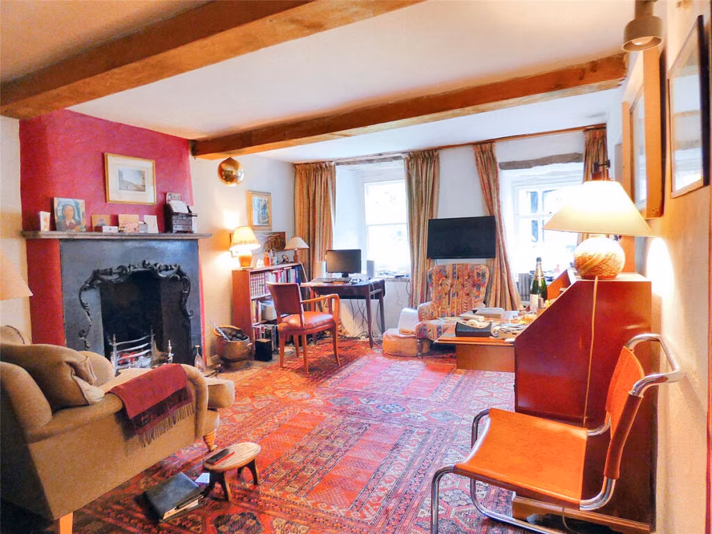
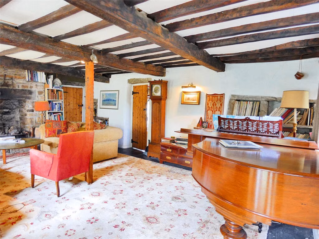
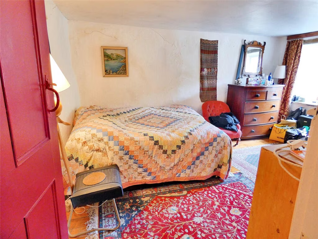
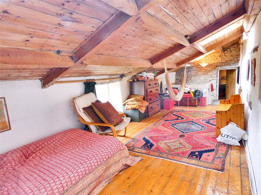
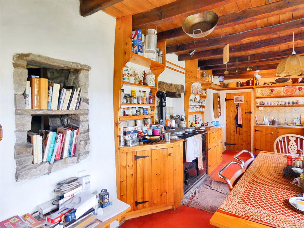
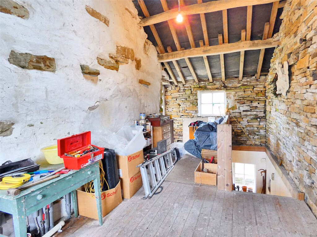
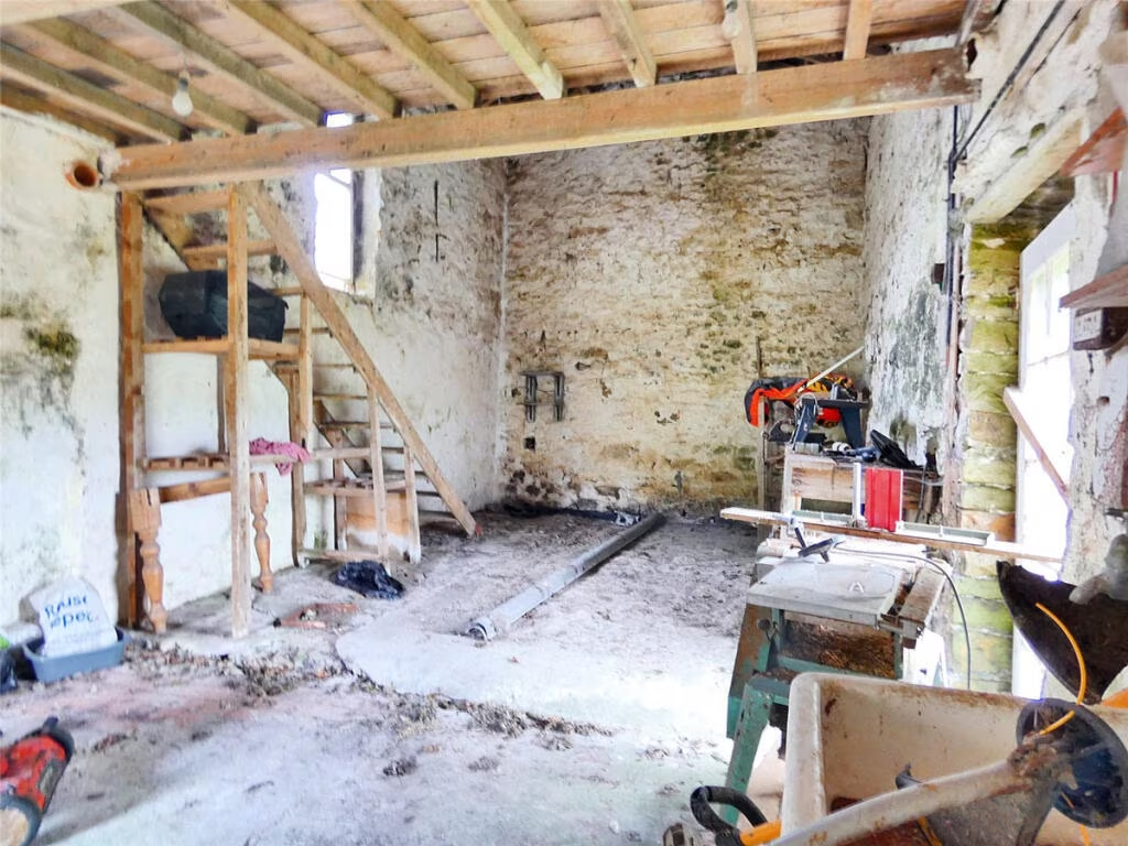
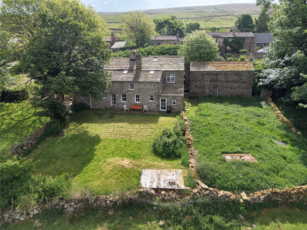
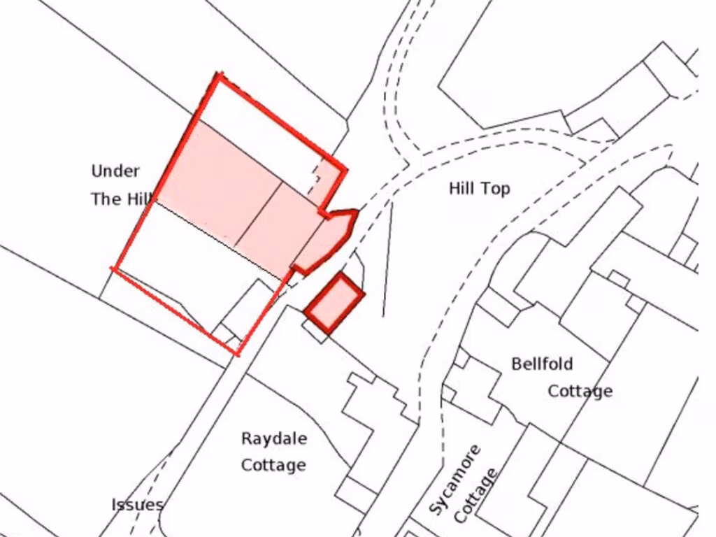
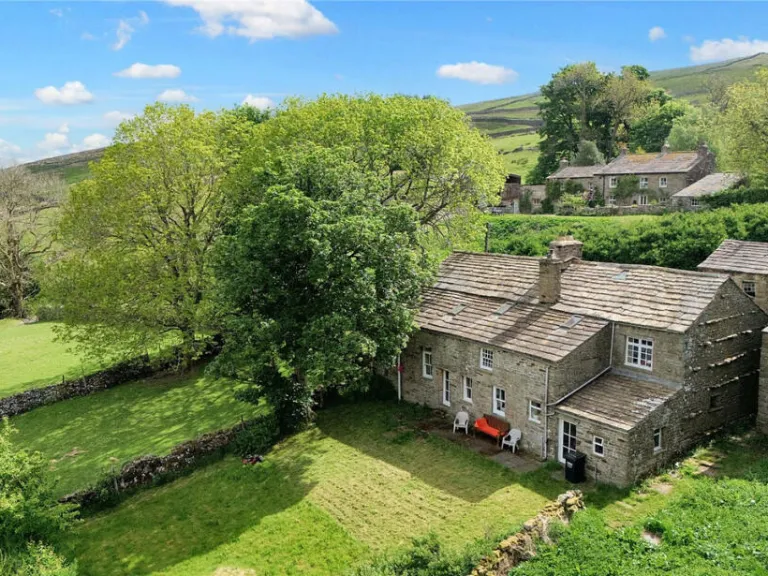
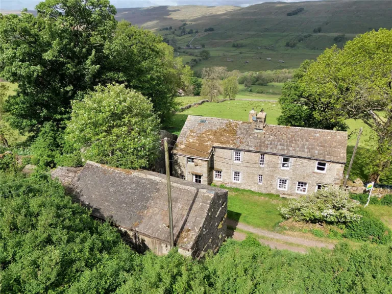
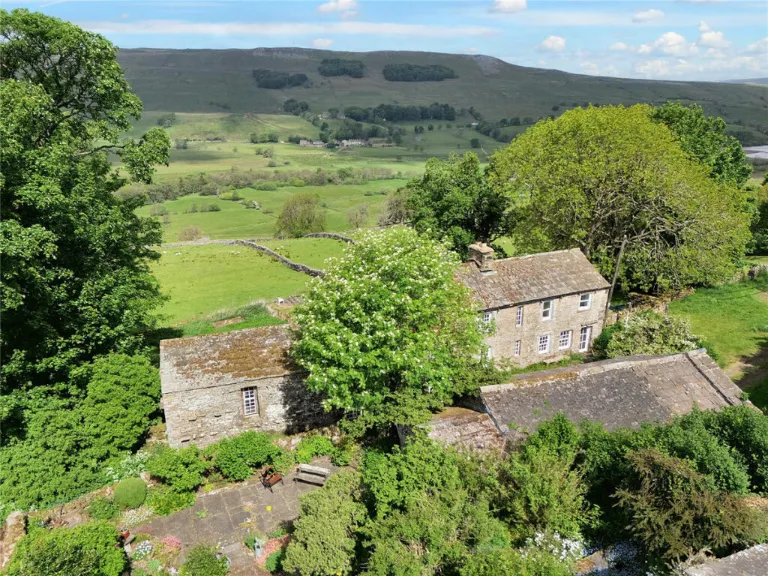
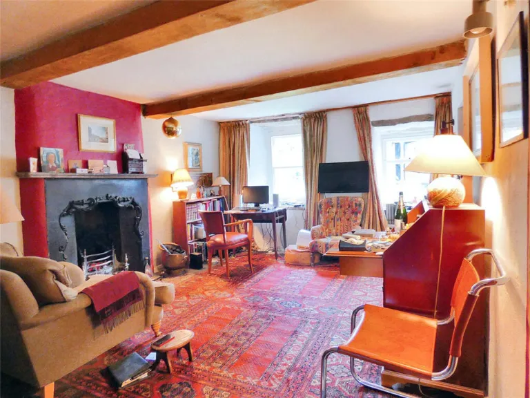
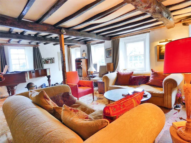
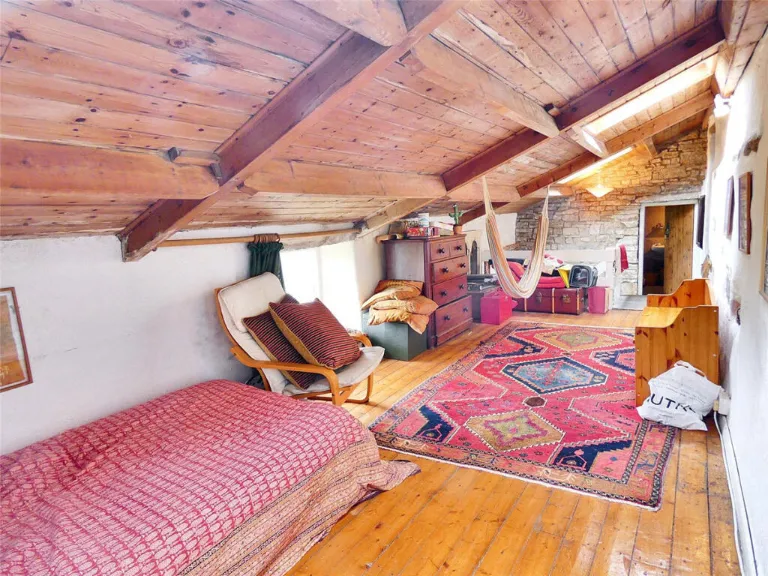
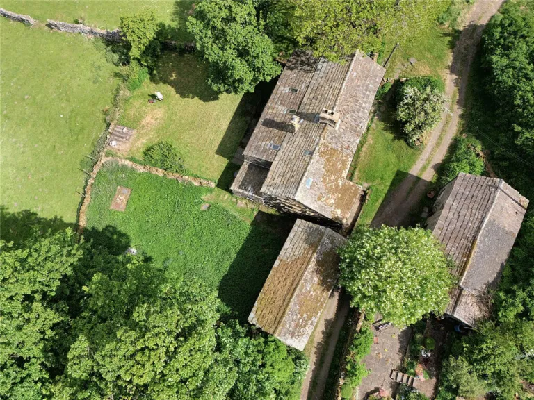
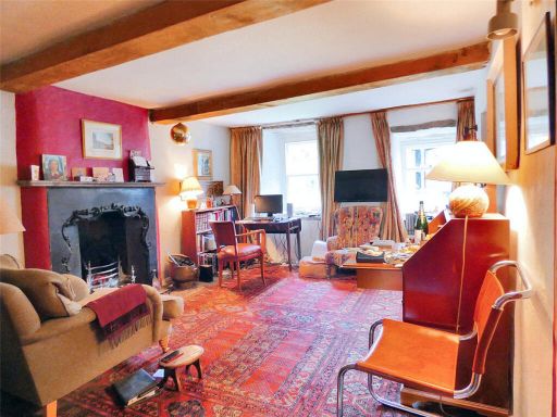
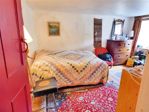
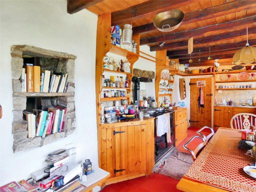
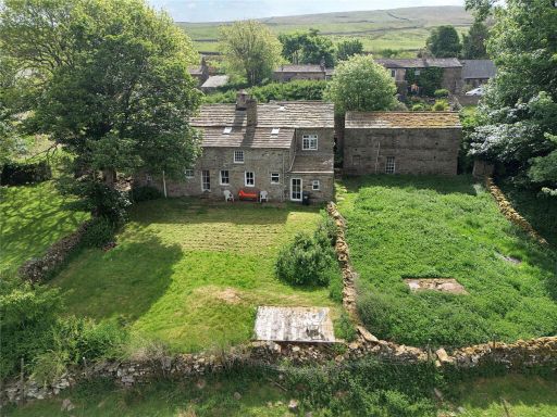
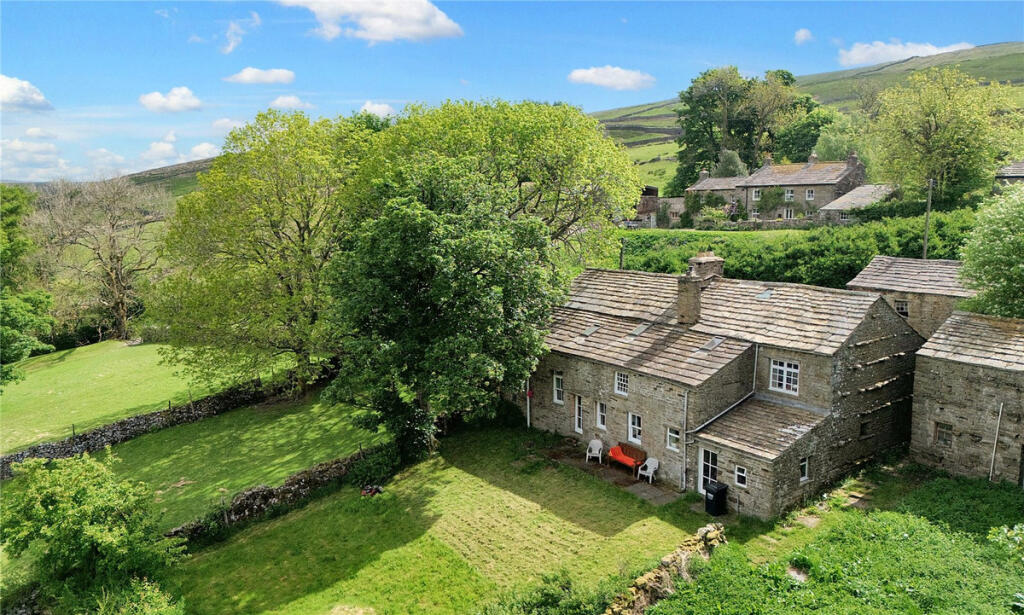
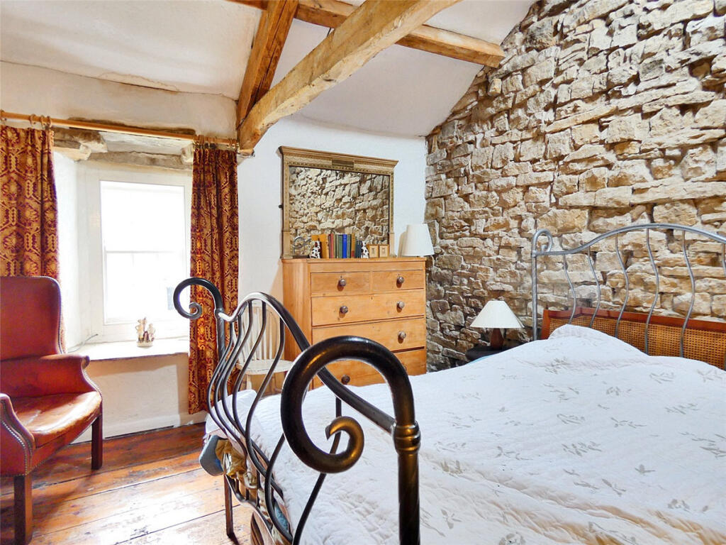
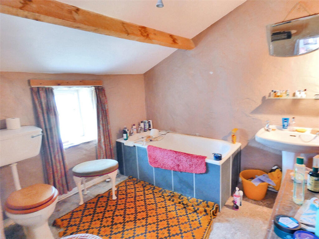
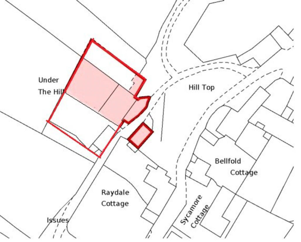
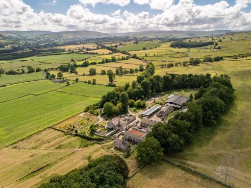
- Traditional stone farmhouse with adjoining barns set in a peaceful rural location with panoramic Dales views. The principal farmhouse offers substantial accommodation including five double bedrooms, two bathrooms, lounge and snug with period features, a large kitchen with pantry, utility room and an adjoining annexe. Attached/detached stone barns present development potential. The gardens are extensive and mature with trees and subdivided lawns/field areas — garden size large and the overall property footprint is substantial, characteristic of a smallholding. Modernisation is required throughout; the setting and scope for enhancement/development would be attractive to purchasers seeking a countryside renovation project or conversion opportunity.
Image Descriptions
- stone cottage traditional country
- rural stone farmhouse with outbuilding Traditional Stone Farmhouse
Floorplan Description
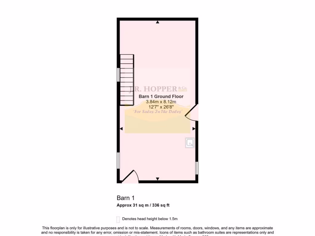
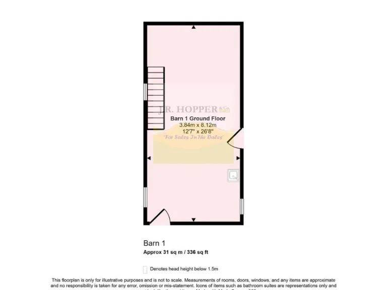
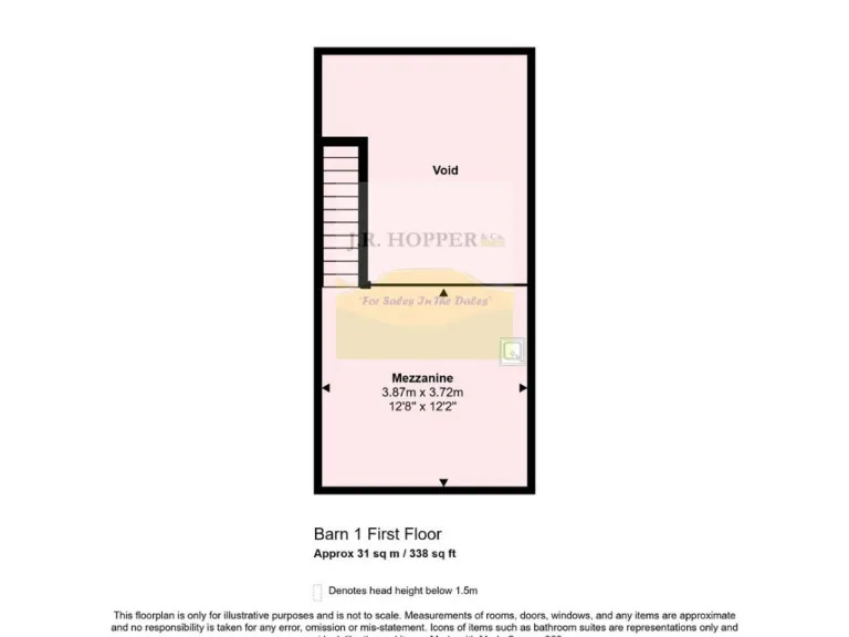
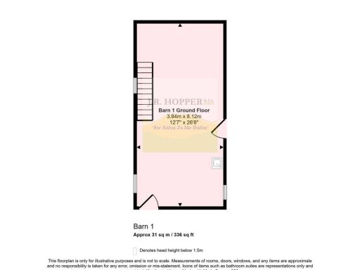
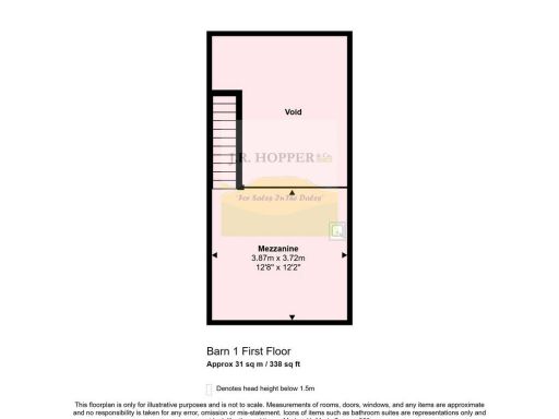
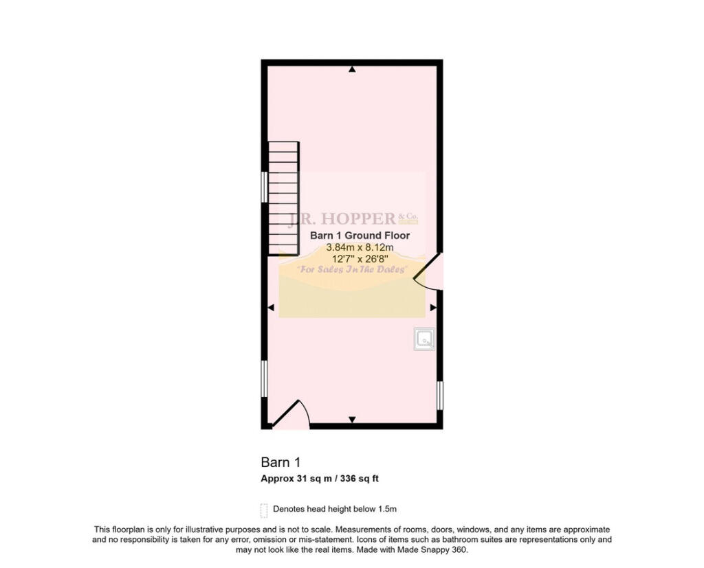
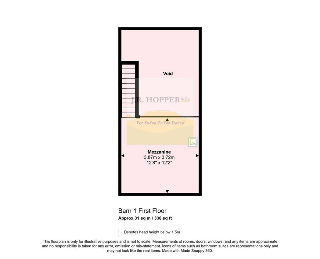
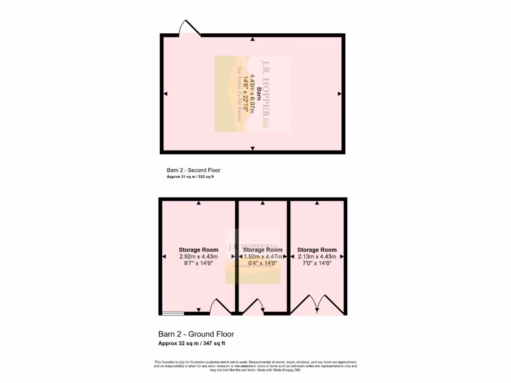
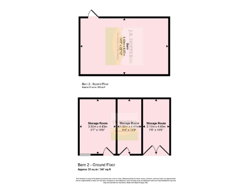
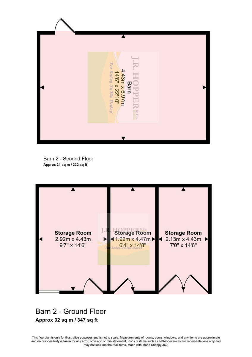
- Two-floor barn with three ground-floor storage rooms and a second-floor barn area.
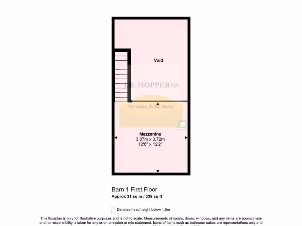
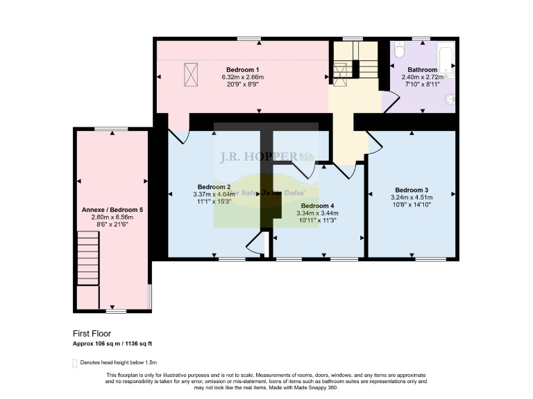
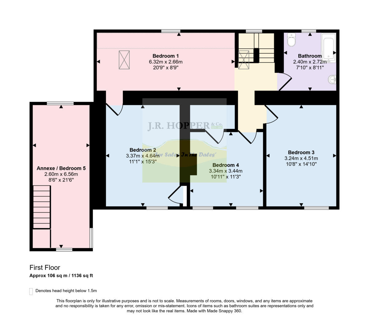
- First floor plan showing six rooms (including an annexe).
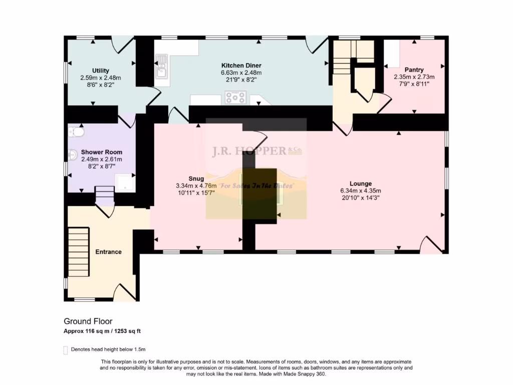
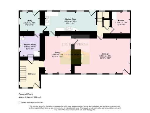
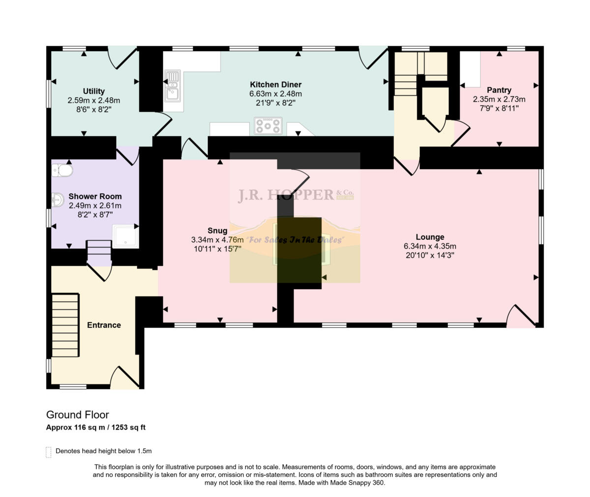
- Ground floor plan showing kitchen diner, lounge, snug, utility, shower room, pantry and entrance.
Rooms
- Barn:
- Storage Room:
- Storage Room:
- Storage Room:
- Bedroom 1:
- Bathroom:
- Bedroom 3:
- Bedroom 4:
- Bedroom 2:
- Annexe / Bedroom 5:
- Utility: small
- Kitchen Diner: large
- Pantry: small
- Shower Room: small
- Snug: average
- Lounge: large
- Entrance:
Textual Property Features
Detected Visual Features
- cottage
- traditional
- stone
- country
- garden
- landscape
- rustic
- rural
- countryside
- farmhouse
- outbuilding
- barn
- character
- detached
- views
- renovation
- restoration
EPC Details
- Fully double glazed
- Granite or whinstone, as built, no insulation (assumed)
- Boiler and radiators, oil
- Low energy lighting in all fixed outlets
- Solid, no insulation (assumed)
Nearby Schools
- Askrigg Voluntary Controlled Primary School
- Bainbridge Church of England Primary and Nursery School
- Hawes Primary School
Nearest Bars And Restaurants
- Id: 6420965237
- Tags:
- Amenity: restaurant
- Cuisine: regional
- Description: Part of Wensleydale Creamery. Serves tea, coffee, cheese, sandwiches
- Fixme: please place on exact builing - this opened since I visited.
- Name: Calvert's Restaurant
- Operator: Wensleydale Dairy Products Limited
- TagsNormalized:
- Lat: 54.3023222
- Lon: -2.2003208
- FullGeoHash: gcwkvvmvby9c
- PartitionGeoHash: gcwk
- Images:
- FoodStandards: null
- Distance: 5841.8
,- Id: 479499965
- Tags:
- Addr:
- Postcode: DL8 3QZ
- Street: Market Place
- Amenity: cafe
- Cuisine: coffee_shop
- Name: Caffe Curva
- TagsNormalized:
- Lat: 54.3040248
- Lon: -2.1976088
- FullGeoHash: gcwkvvxzb5bj
- PartitionGeoHash: gcwk
- Images:
- FoodStandards: null
- Distance: 5830.2
,- Id: 371802346
- Tags:
- Accommodation: yes
- Amenity: pub
- Food: yes
- Name: White Hart Inn
- Real_ale: yes
- TagsNormalized:
- Lat: 54.3038526
- Lon: -2.1969312
- FullGeoHash: gcwkyj8nzgc6
- PartitionGeoHash: gcwk
- Images:
- FoodStandards: null
- Distance: 5784.6
,- Id: 4002252789
- Tags:
- Amenity: pub
- Food: no
- Internet_access: no
- Name: The Victoria Arms
- Wikidata: Q26424963
- TagsNormalized:
- Lat: 54.305195
- Lon: -2.0663532
- FullGeoHash: gcwsbvzqdqp6
- PartitionGeoHash: gcws
- Images:
- FoodStandards: null
- Distance: 5775.2
,- Id: 449334152
- Tags:
- Addr:
- Amenity: pub
- Brewery: free_house
- Free_house: yes
- Name: Rose & Crown
- Phone: +44 1969 650225
- Real_ale: yes
- Website: http://www.theprideofwensleydale.co.uk/
- TagsNormalized:
- Lat: 54.3086145
- Lon: -2.1032732
- FullGeoHash: gcwsbns6w5tb
- PartitionGeoHash: gcws
- Images:
- FoodStandards: null
- Distance: 4726.2
}
Nearest General Shops
- Id: 390503358
- Tags:
- Name: Three Peaks Outdoor Leisure
- Shop: outdoor
- TagsNormalized:
- Lat: 54.30361
- Lon: -2.1951172
- FullGeoHash: gcwkyj9t6n9g
- PartitionGeoHash: gcwk
- Images:
- FoodStandards: null
- Distance: 5679.2
,- Id: 479499966
- Tags:
- Name: Flairs & Graces
- Shop: clothes
- TagsNormalized:
- Lat: 54.3037193
- Lon: -2.1947398
- FullGeoHash: gcwkyj9y4fgr
- PartitionGeoHash: gcwk
- Images:
- FoodStandards: null
- Distance: 5669.3
,- Id: 479493314
- Tags:
- Name: Country Images
- Shop: art
- TagsNormalized:
- Lat: 54.3035767
- Lon: -2.1945173
- FullGeoHash: gcwkyjdj203k
- PartitionGeoHash: gcwk
- Images:
- FoodStandards: null
- Distance: 5647.9
}
Nearest Grocery shops
- Id: 1352951385
- Tags:
- Addr:
- City: Skipton
- Country: GB
- Hamlet: Buckden
- Postcode: BD23 5JA
- Street: Buckden Wood Lane
- Fhrs:
- Name: Buckden Village Store
- Shop: convenience
- Source:
- TagsNormalized:
- Lat: 54.1912206
- Lon: -2.0905681
- FullGeoHash: gcws23jwwpxq
- PartitionGeoHash: gcws
- Images:
- FoodStandards: null
- Distance: 9049.4
,- Id: 541436698
- Tags:
- Brand: Spar
- Brand:wikidata: Q610492
- Brand:wikipedia: en:SPAR (retailer)
- Name: Spar
- Operator: J. Blades & Sons
- Shop: convenience
- TagsNormalized:
- Lat: 54.3039384
- Lon: -2.1987417
- FullGeoHash: gcwkvvwzmeg6
- PartitionGeoHash: gcwk
- Images:
- FoodStandards: null
- Distance: 5879
,- Id: 5079290288
- Tags:
- Name: Elijah Allen & Son
- Shop: convenience
- TagsNormalized:
- Lat: 54.3038401
- Lon: -2.1980874
- FullGeoHash: gcwkvvxquc7p
- PartitionGeoHash: gcwk
- Images:
- FoodStandards: null
- Distance: 5839.9
}
Nearest Religious buildings
- Id: 1086985555
- Tags:
- Amenity: place_of_worship
- Denomination: methodist
- Name: Methodist Chapel
- Religion: christian
- TagsNormalized:
- place of worship
- methodist
- chapel
- christian
- church
- Lat: 54.3069616
- Lon: -2.1042525
- FullGeoHash: gcwsbn78zr7s
- PartitionGeoHash: gcws
- Images:
- FoodStandards: null
- Distance: 4532
,- Id: 534100047
- Tags:
- Amenity: place_of_worship
- Denomination: methodist
- Is_in: Marsett
- Is_in:country_code: GB
- Is_in:county: North Yorkshire
- Is_in:municipality: Richmondshire
- Name: Marsett Methodist Chapel
- Religion: christian
- Source: os_25k_firstseries
- TagsNormalized:
- place of worship
- methodist
- chapel
- christian
- church
- Lat: 54.271293
- Lon: -2.1516626
- FullGeoHash: gcwkxpc1nwk0
- PartitionGeoHash: gcwk
- Images:
- FoodStandards: null
- Distance: 1395.3
,- Id: 848882416
- Tags:
- Amenity: place_of_worship
- Building: church
- Denomination: anglican
- Name: St Matthew
- Religion: christian
- Wikidata: Q18708786
- Wikipedia: en:St Matthew's Church, Stalling Busk
- TagsNormalized:
- place of worship
- church
- anglican
- christian
- Lat: 54.2686612
- Lon: -2.1301712
- FullGeoHash: gcwkxx2cg7tj
- PartitionGeoHash: gcwk
- Images:
- FoodStandards: null
- Distance: 61.9
}
Nearest Medical buildings
- Id: 34644974
- Tags:
- Boat: no
- Name: Doctor Gill
- Source: aerial imagery;OS OpenData StreetView (April 2016)
- Waterway: stream
- TagsNormalized:
- Lat: 54.4126932
- Lon: -2.0700247
- FullGeoHash: gcwt8cs8uvjw
- PartitionGeoHash: gcwt
- Images:
- FoodStandards: null
- Distance: 16431.1
,- Id: 11373887
- Tags:
- Name: Doctor Wood
- Natural: wood
- Source:
- Name: OS_OpenData_StreetView
- Type: multipolygon
- TagsNormalized:
- Lat: 54.3794767
- Lon: -2.1555853
- FullGeoHash: gcwmqgqr7jpj
- PartitionGeoHash: gcwm
- Images:
- FoodStandards: null
- Distance: 12371.1
,- Id: 389379270
- Tags:
- Amenity: doctors
- Building: yes
- Healthcare: doctor
- Source: bing
- TagsNormalized:
- doctor
- doctors
- health
- healthcare
- Lat: 54.2892877
- Lon: -1.9891109
- FullGeoHash: gcwsfepd42er
- PartitionGeoHash: gcws
- Images:
- FoodStandards: null
- Distance: 9445.7
,- Id: 1167203499
- Tags:
- Amenity: pharmacy
- Dispensing: yes
- Healthcare: pharmacy
- Name: John Hogg
- TagsNormalized:
- Lat: 54.3038043
- Lon: -2.1978713
- FullGeoHash: gcwkvvxw9fu6
- PartitionGeoHash: gcwk
- Images:
- FoodStandards: null
- Distance: 5826.7
}
Nearest Leisure Facilities
- Id: 1116607767
- Tags:
- Leisure: playground
- Playground: structure
- TagsNormalized:
- Lat: 54.308035
- Lon: -2.1027124
- FullGeoHash: gcwsbnkz5prz
- PartitionGeoHash: gcws
- Images:
- FoodStandards: null
- Distance: 4680.4
,- Id: 858454605
- Tags:
- Leisure: playground
- Playground: zipwire
- TagsNormalized:
- Lat: 54.3080582
- Lon: -2.1029029
- FullGeoHash: gcwsbnkxqgcc
- PartitionGeoHash: gcws
- Images:
- FoodStandards: null
- Distance: 4678
,- Id: 1116607769
- Tags:
- Leisure: playground
- Playground: basketswing
- TagsNormalized:
- Lat: 54.307976
- Lon: -2.1026682
- FullGeoHash: gcwsbnkyuk2z
- PartitionGeoHash: gcws
- Images:
- FoodStandards: null
- Distance: 4675.4
,- Id: 1116607768
- Tags:
- Leisure: playground
- Playground: basketswing
- TagsNormalized:
- Lat: 54.3079634
- Lon: -2.1027451
- FullGeoHash: gcwsbnkyf6ps
- PartitionGeoHash: gcws
- Images:
- FoodStandards: null
- Distance: 4672.2
,- Id: 1116607766
- Tags:
- Leisure: pitch
- Lit: no
- Sport: soccer
- Surface: grass
- TagsNormalized:
- Lat: 54.3075963
- Lon: -2.1028665
- FullGeoHash: gcwsbnksxttn
- PartitionGeoHash: gcws
- Images:
- FoodStandards: null
- Distance: 4631.5
}
Nearest Tourist attractions
- Id: 1380898495
- Tags:
- Guest_house: bed_and_breakfast
- Name: Spring Bank House
- Stars: 3
- Tourism: guest_house
- TagsNormalized:
- Lat: 54.3029913
- Lon: -2.1940838
- FullGeoHash: gcwkyjd3f5k8
- PartitionGeoHash: gcwk
- Images:
- FoodStandards: null
- Distance: 5583.3
,- Id: 350404973
- Tags:
- Addr:
- City: Hawes
- Postcode: DL8 3NP
- Street: Burtersett Road
- Building: yes
- Name: Fair View House
- Phone: +44 19 69 66 73 48
- Tourism: guest_house
- Website: http://www.fairview-hawes.co.uk/
- TagsNormalized:
- Lat: 54.3028984
- Lon: -2.188788
- FullGeoHash: gcwkyjw1m9cq
- PartitionGeoHash: gcwk
- Images:
- FoodStandards: null
- Distance: 5326.8
,- Id: 131549183
- Tags:
- Name: Bainbridge Ings Caravan & Campsite
- Source: bing
- Source:name: local_knowledge
- Tourism: camp_site
- TagsNormalized:
- Lat: 54.3002839
- Lon: -2.1859095
- FullGeoHash: gcwkym060ded
- PartitionGeoHash: gcwk
- Images:
- FoodStandards: null
- Distance: 4990.2
}
Nearest Train stations
- Id: 20975875
- Tags:
- Name: Horton-in-Ribblesdale
- Naptan:
- Network: National Rail
- Public_transport: station
- Railway: station
- Ref:
- Source: NPE
- Wikidata: Q5906817
- Wikipedia: en:Horton-in-Ribblesdale railway station
- TagsNormalized:
- Lat: 54.149217
- Lon: -2.3020982
- FullGeoHash: gcwk59edj1xj
- PartitionGeoHash: gcwk
- Images:
- FoodStandards: null
- Distance: 17393
,- Id: 20975595
- Tags:
- Name: Ribblehead
- Naptan:
- Network: National Rail
- Operator: Northern
- Public_transport: station
- Railway: station
- Ref: RHD
- Ref:crs: RHD
- Source: NPE
- Wikidata: Q2801135
- Wikipedia: en:Ribblehead railway station
- TagsNormalized:
- Lat: 54.2054988
- Lon: -2.3603709
- FullGeoHash: gcwk67c1zm7g
- PartitionGeoHash: gcwk
- Images:
- FoodStandards: null
- Distance: 16533.3
,- Id: 20975586
- Tags:
- Name: Dent
- Naptan:
- Network: National Rail
- Public_transport: station
- Railway: station
- Ref:
- Source: NPE
- Train: yes
- Wikidata: Q2319302
- Wikipedia: en:Dent railway station
- TagsNormalized:
- Lat: 54.2825661
- Lon: -2.3636343
- FullGeoHash: gcwkf1yfg7dx
- PartitionGeoHash: gcwk
- Images:
- FoodStandards: null
- Distance: 15210.5
,- Id: 92973951
- Tags:
- Name: Redmire
- Naptan:
- Network: Wensleydale Railway
- Operator: Wensleydale Railway Association
- Public_transport: station
- Railway: station
- Source: OS OpenData StreetView
- Source:name: NPE
- Train: yes
- Usage: tourism
- Wikidata: Q7306097
- TagsNormalized:
- Lat: 54.3191529
- Lon: -1.9284688
- FullGeoHash: gcwth0e8p2j2
- PartitionGeoHash: gcwt
- Images:
- FoodStandards: null
- Distance: 14238.3
,- Id: 20972511
- Tags:
- Name: Garsdale
- Naptan:
- Network: National Rail
- Public_transport: station
- Railway: station
- Ref:
- Source: NPE
- Wikidata: Q2145153
- Wikipedia: en:Garsdale railway station
- TagsNormalized:
- Lat: 54.3214617
- Lon: -2.3263682
- FullGeoHash: gcwm50cvrwqh
- PartitionGeoHash: gcwm
- Images:
- FoodStandards: null
- Distance: 13978
}
Nearest Bus stations and stops
- Id: 1583027691
- Tags:
- Bench: yes
- Bus: yes
- Departures_board: timetable
- Highway: bus_stop
- Name: Dales Museum
- Public_transport: platform
- Timetable: yes
- TagsNormalized:
- Lat: 54.3045132
- Lon: -2.1927298
- FullGeoHash: gcwkyjg69wyp
- PartitionGeoHash: gcwk
- Images:
- FoodStandards: null
- Distance: 5635.2
,- Id: 10000661910
- Tags:
- Bench: yes
- Bus: yes
- Departures_board: timetable
- Highway: bus_stop
- Name: Woton
- Physically_present: yes
- Public_transport: platform
- Shelter: yes
- Waste_basket: yes
- TagsNormalized:
- Lat: 54.3057947
- Lon: -2.0711699
- FullGeoHash: gcwsby5f4jzg
- PartitionGeoHash: gcws
- Images:
- FoodStandards: null
- Distance: 5602.4
,- Id: 10000661911
- Tags:
- Bus: yes
- Departures_board: timetable
- Highway: bus_stop
- Name: Woton
- Physically_present: yes
- Public_transport: platform
- Shelter: no
- TagsNormalized:
- Lat: 54.3056524
- Lon: -2.0709158
- FullGeoHash: gcwsbyh125m6
- PartitionGeoHash: gcws
- Images:
- FoodStandards: null
- Distance: 5602.3
,- Id: 1382082951
- Tags:
- Bench: yes
- Bin: yes
- Bus: yes
- Departures_board: timetable
- Highway: bus_stop
- Name: Bainbridge Green
- Public_transport: platform
- Shelter: yes
- TagsNormalized:
- Lat: 54.3081327
- Lon: -2.1032344
- FullGeoHash: gcwsbnkrz1dy
- PartitionGeoHash: gcws
- Images:
- FoodStandards: null
- Distance: 4677.5
,- Id: 8002799592
- Tags:
- Bench: no
- Bus: yes
- Departures_board: timetable
- Highway: bus_stop
- Lit: yes
- Name: Bainbridge Green
- Public_transport: platform
- Shelter: no
- TagsNormalized:
- Lat: 54.3080922
- Lon: -2.1030944
- FullGeoHash: gcwsbnkxd65h
- PartitionGeoHash: gcws
- Images:
- FoodStandards: null
- Distance: 4676.8
}
Nearest Hotels
- Id: 737034112
- Tags:
- Brand: Holiday Property Bond
- Name: Lodge Yard
- Tourism: hotel
- Website: https://www.hpb.co.uk/property-portfolio/lodge-yard/details
- TagsNormalized:
- Lat: 54.3156135
- Lon: -2.0801732
- FullGeoHash: gcwsbxv72knr
- PartitionGeoHash: gcws
- Images:
- FoodStandards: null
- Distance: 6107.9
,- Id: 378382747
- Tags:
- Addr:
- Postcode: DL8 3HG
- Street: Main Street
- Amenity: pub
- Beer_garden: yes
- Building: commercial
- Name: The White Rose Hotel
- Source:
- Website: https://www.thewhiterosehotelaskrigg.co.uk/
- TagsNormalized:
- Lat: 54.3151619
- Lon: -2.0796942
- FullGeoHash: gcwsbxv8g859
- PartitionGeoHash: gcws
- Images:
- FoodStandards: null
- Distance: 6082.4
,- Id: 454654298
- Tags:
- Addr:
- City: Hawes
- Postcode: DL8 3QW
- Street: Main Street
- Email: info@herriotsinhawes.co.uk
- Internet_access: wlan
- Internet_access:fee: no
- Internet_access:ssid: Herriots cafe_EXT
- Name: Herriots Guest House
- Phone: +44 1969 667 536
- Stars: 4
- Tourism: hotel
- Website: https://herriotsinhawes.co.uk/
- TagsNormalized:
- Lat: 54.3036232
- Lon: -2.196326
- FullGeoHash: gcwkyj8ttchd
- PartitionGeoHash: gcwk
- Images:
- FoodStandards: null
- Distance: 5738.3
}
Tags
- cottage
- traditional
- stone
- country
- garden
- landscape
- rustic
- rural
- countryside
- countryside
- stone
- farmhouse
- traditional
- rural
- outbuilding
- barn
- character
- detached
- landscape
- views
- renovation
- restoration
Similar Properties
 Farm for sale in Castle Gate Farm, Leyburn, DL8 — £1,800,000 • 3 bed • 1 bath • 8942 ft²
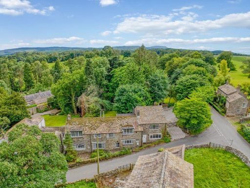 5 bedroom detached house for sale in 3500sqft House. 1 acre with paddock. Flasby, Yorkshire Dales, BD23 — £899,950 • 5 bed • 3 bath • 3500 ft²
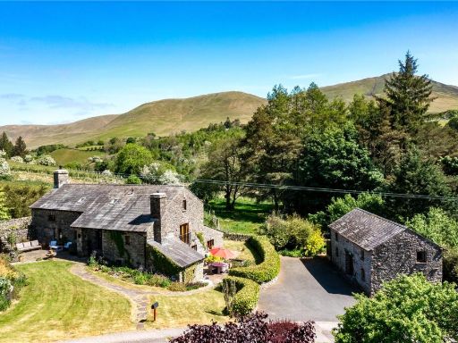 6 bedroom detached house for sale in Lowgill, Kendal, Cumbria, LA8 — £800,000 • 6 bed • 5 bath • 3338 ft²
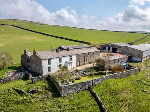 4 bedroom detached house for sale in Hill Top Farm, Arkengarthdale, Richmond, DL11 6RR, DL11 — £575,000 • 4 bed • 2 bath • 3810 ft²
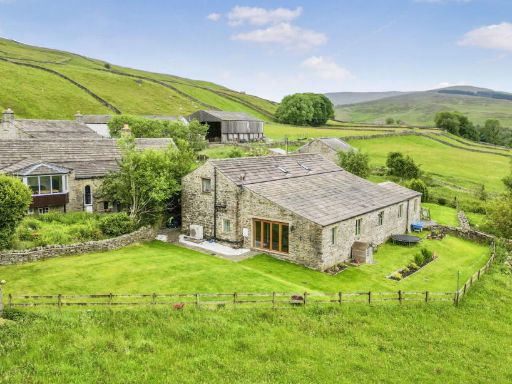 5 bedroom detached house for sale in Stalling Busk, Askrigg, Leyburn, DL8 3DH, DL8 — £550,000 • 5 bed • 2 bath • 2239 ft²
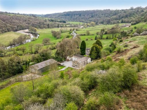 5 bedroom detached house for sale in Reeth Road, Richmond, DL10 — £1,150,000 • 5 bed • 3 bath • 3700 ft²
Meta
- {
"@context": "https://schema.org",
"@type": "Residence",
"name": "3 bedroom detached house for sale in Under The Hill Stallin…",
"description": "",
"url": "https://propertypiper.co.uk/property/d701e021-04be-48ba-a0c3-3c8617a94dad",
"image": "https://image-a.propertypiper.co.uk/7da63ebd-5a19-42ce-999e-dd7412ab2e70-1024.jpeg",
"address": {
"@type": "PostalAddress",
"streetAddress": "UNDER THE HILL, STALLING BUSK VILLAGE STREETS",
"postalCode": "DL8 3DH",
"addressLocality": "Richmondshire",
"addressRegion": "Richmond (Yorks)",
"addressCountry": "England"
},
"geo": {
"@type": "GeoCoordinates",
"latitude": 54.26918854229152,
"longitude": -2.1304781557527814
},
"numberOfRooms": 3,
"numberOfBathroomsTotal": 2,
"floorSize": {
"@type": "QuantitativeValue",
"value": 3054,
"unitCode": "FTK"
},
"offers": {
"@type": "Offer",
"price": 500000,
"priceCurrency": "GBP",
"availability": "https://schema.org/InStock"
},
"additionalProperty": [
{
"@type": "PropertyValue",
"name": "Feature",
"value": "cottage"
},
{
"@type": "PropertyValue",
"name": "Feature",
"value": "traditional"
},
{
"@type": "PropertyValue",
"name": "Feature",
"value": "stone"
},
{
"@type": "PropertyValue",
"name": "Feature",
"value": "country"
},
{
"@type": "PropertyValue",
"name": "Feature",
"value": "garden"
},
{
"@type": "PropertyValue",
"name": "Feature",
"value": "landscape"
},
{
"@type": "PropertyValue",
"name": "Feature",
"value": "rustic"
},
{
"@type": "PropertyValue",
"name": "Feature",
"value": "rural"
},
{
"@type": "PropertyValue",
"name": "Feature",
"value": "countryside"
},
{
"@type": "PropertyValue",
"name": "Feature",
"value": "countryside"
},
{
"@type": "PropertyValue",
"name": "Feature",
"value": "stone"
},
{
"@type": "PropertyValue",
"name": "Feature",
"value": "farmhouse"
},
{
"@type": "PropertyValue",
"name": "Feature",
"value": "traditional"
},
{
"@type": "PropertyValue",
"name": "Feature",
"value": "rural"
},
{
"@type": "PropertyValue",
"name": "Feature",
"value": "outbuilding"
},
{
"@type": "PropertyValue",
"name": "Feature",
"value": "barn"
},
{
"@type": "PropertyValue",
"name": "Feature",
"value": "character"
},
{
"@type": "PropertyValue",
"name": "Feature",
"value": "detached"
},
{
"@type": "PropertyValue",
"name": "Feature",
"value": "landscape"
},
{
"@type": "PropertyValue",
"name": "Feature",
"value": "views"
},
{
"@type": "PropertyValue",
"name": "Feature",
"value": "renovation"
},
{
"@type": "PropertyValue",
"name": "Feature",
"value": "restoration"
}
]
}
High Res Floorplan Images
Compatible Floorplan Images
FloorplanImages Thumbnail