SP11 8BJ - 4 bedroom detached house for sale in Amport, Andover, Hamps…
View on Property Piper
4 bedroom detached house for sale in Amport, Andover, Hampshire, SP11
Property Details
- Price: £3250000
- Bedrooms: 4
- Bathrooms: 1
- Property Type: undefined
- Property SubType: undefined
Brochure Descriptions
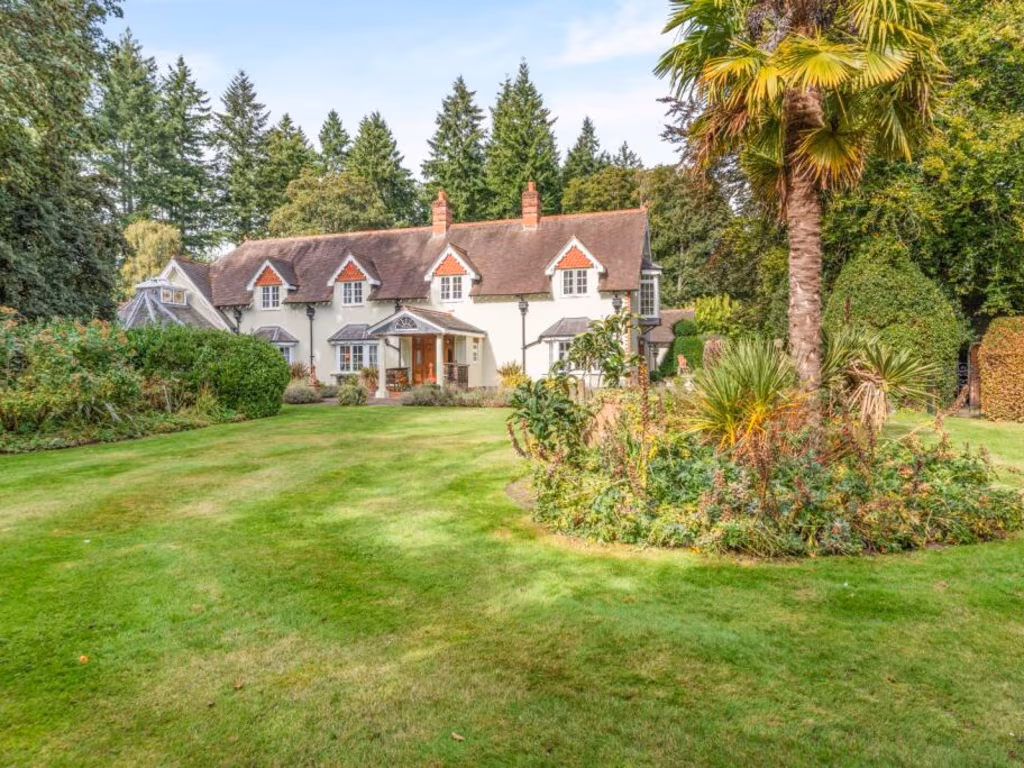
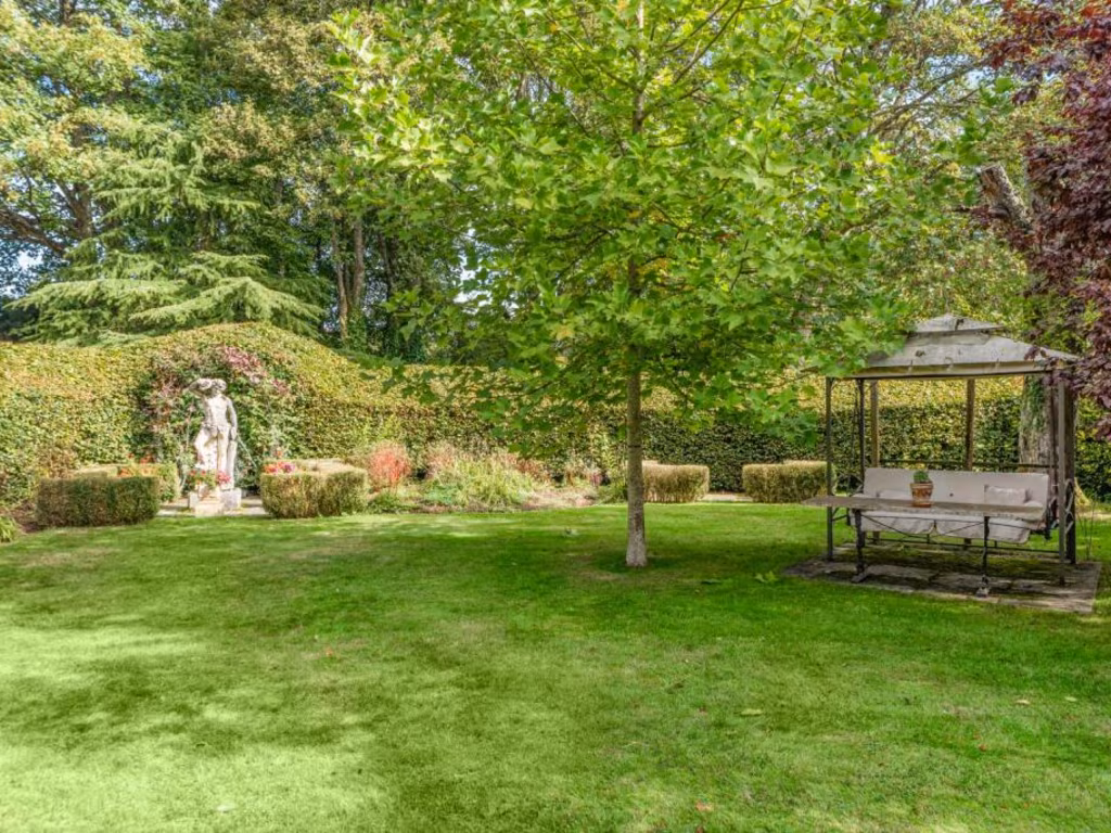
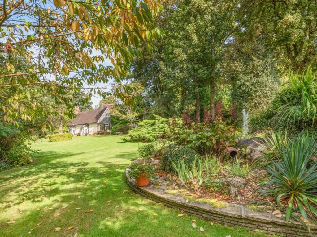
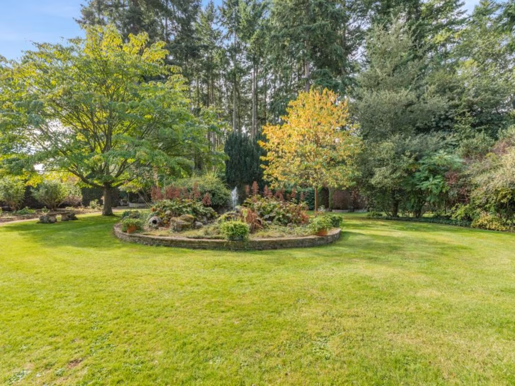
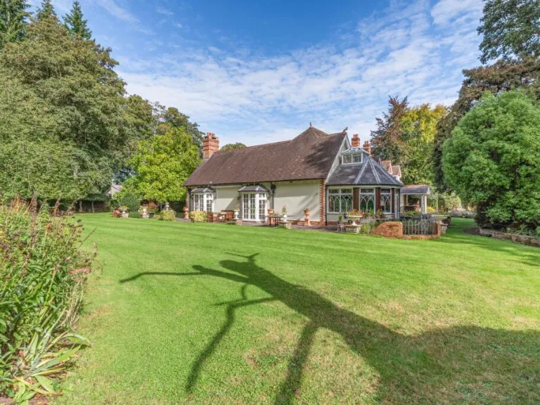
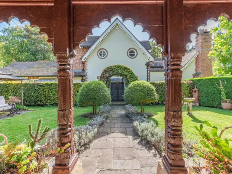
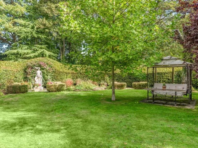
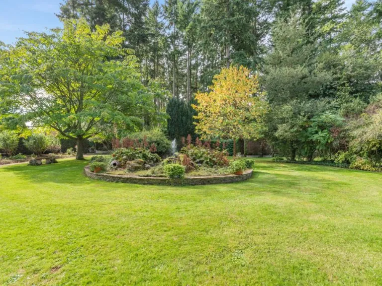
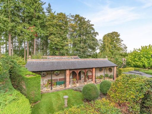
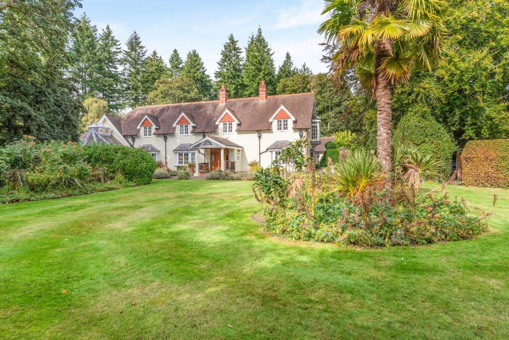
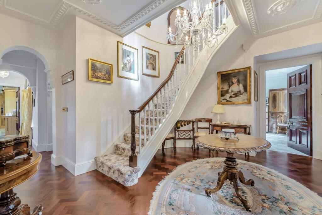
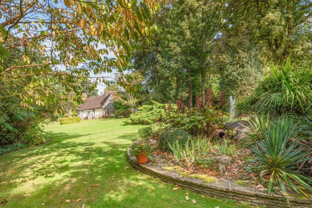
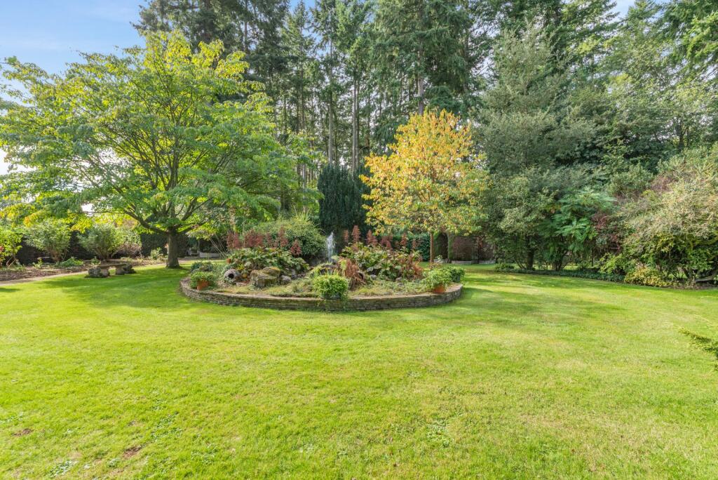
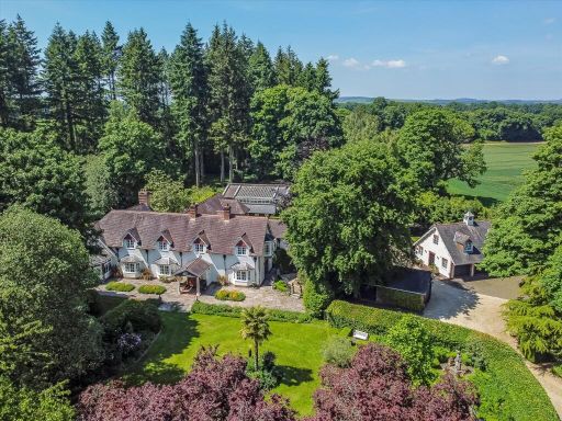
- Substantial detached country residence set within extensive, mature landscaped grounds. The property appears to be a traditional two-storey house with multiple dormer windows, pitched tiled roof and a central porch entrance. Exterior indicates period/vernacular detailing and a sizable footprint suggesting numerous principal rooms. Grounds are large to very large with an expansive formal lawn, mature specimen trees and planting beds, providing strong privacy and amenity value; there is a notable palm and dense woodland backdrop. Overall impression: a large, detached rural family home on generous grounds offering high potential for family living and scope for outbuildings or ancillary uses. Garden size: large/very large. Overall property size: large (substantial house plus extensive grounds).
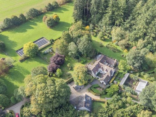
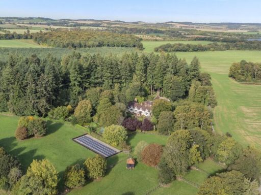
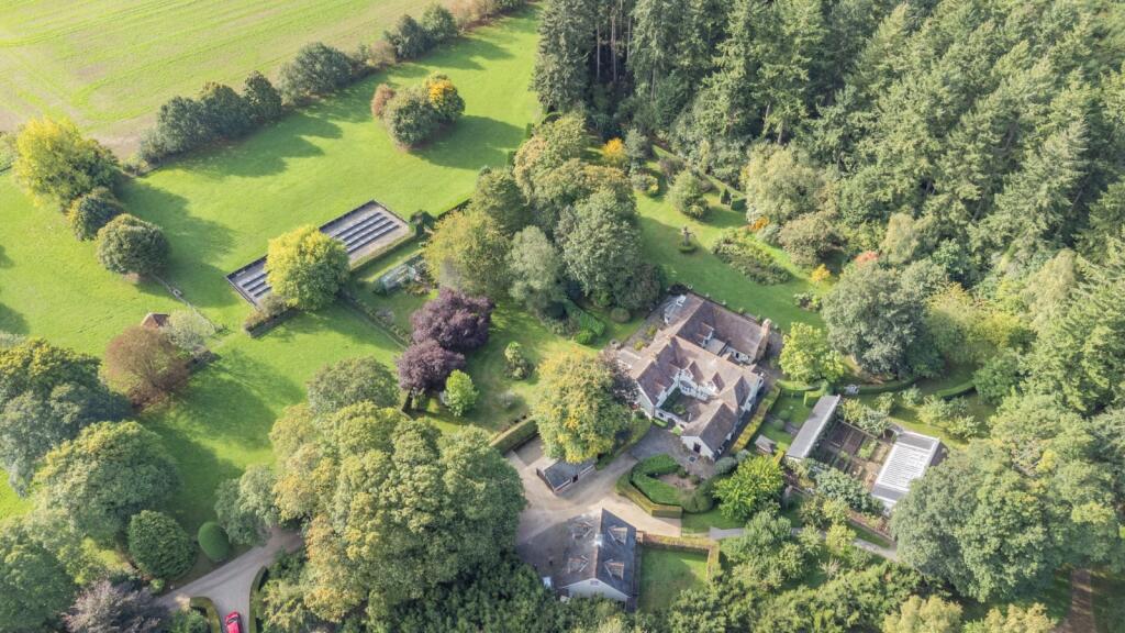
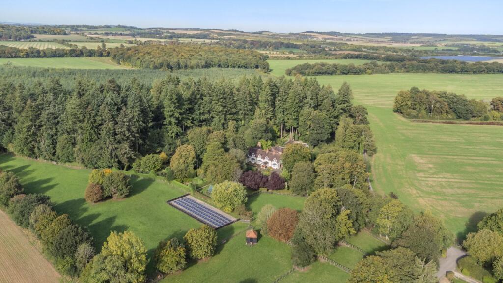
- Large detached country residence set within extensive mature woodland and parkland. The property appears to be a substantial period house (multiple gables) located in a secluded wooded setting with formal gardens directly around the house and open pasture beyond. Notable features visible: a long rectangular solar array in an enclosed paddock, dense mixed-species shelter belt/woodland immediately adjoining the rear of the house, a private driveway approach through trees, and several fenced paddocks. The site offers privacy and is likely suitable for equestrian or smallholding uses given the fenced grazing parcels. Garden size: large (formal gardens immediately surrounding the house plus extensive grounds). Overall property size: very large estate-type grounds (difficult to quantify from aerial image alone). Views: rural and rolling agricultural countryside with woodland vistas.
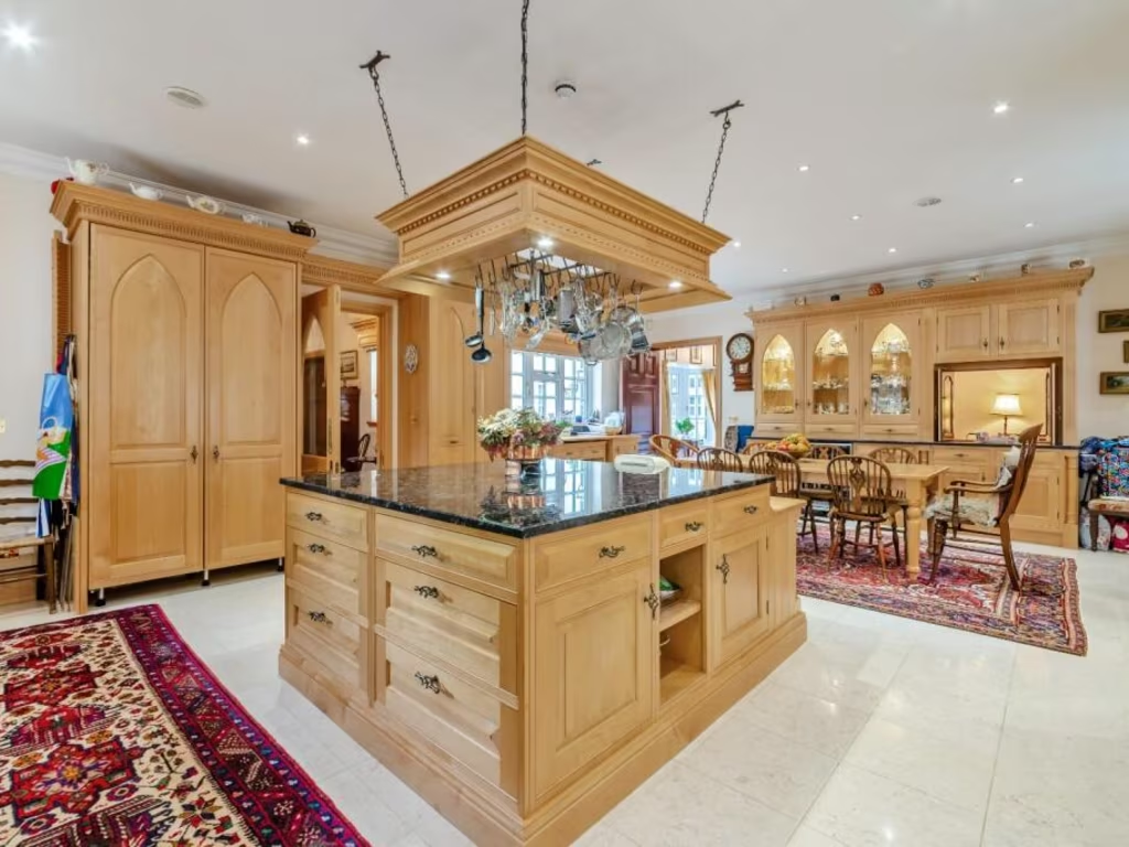
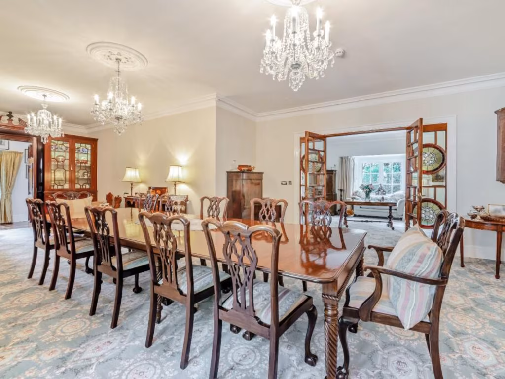
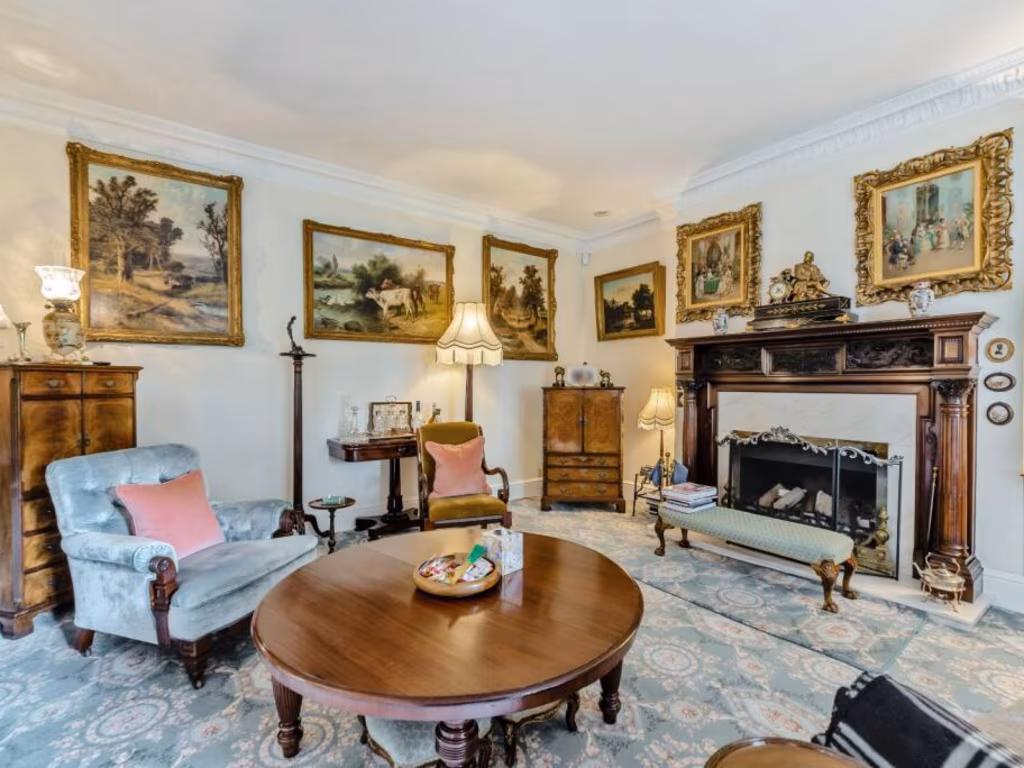
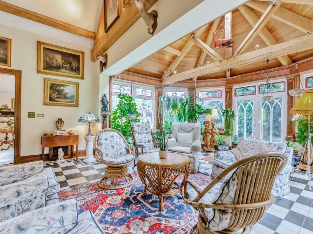
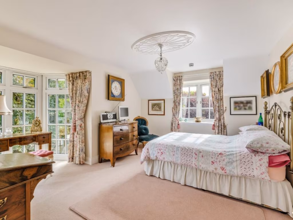
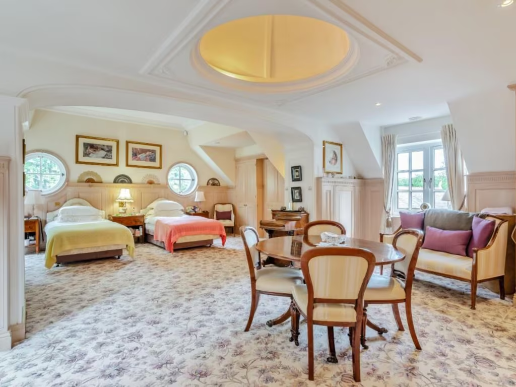
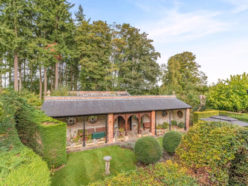
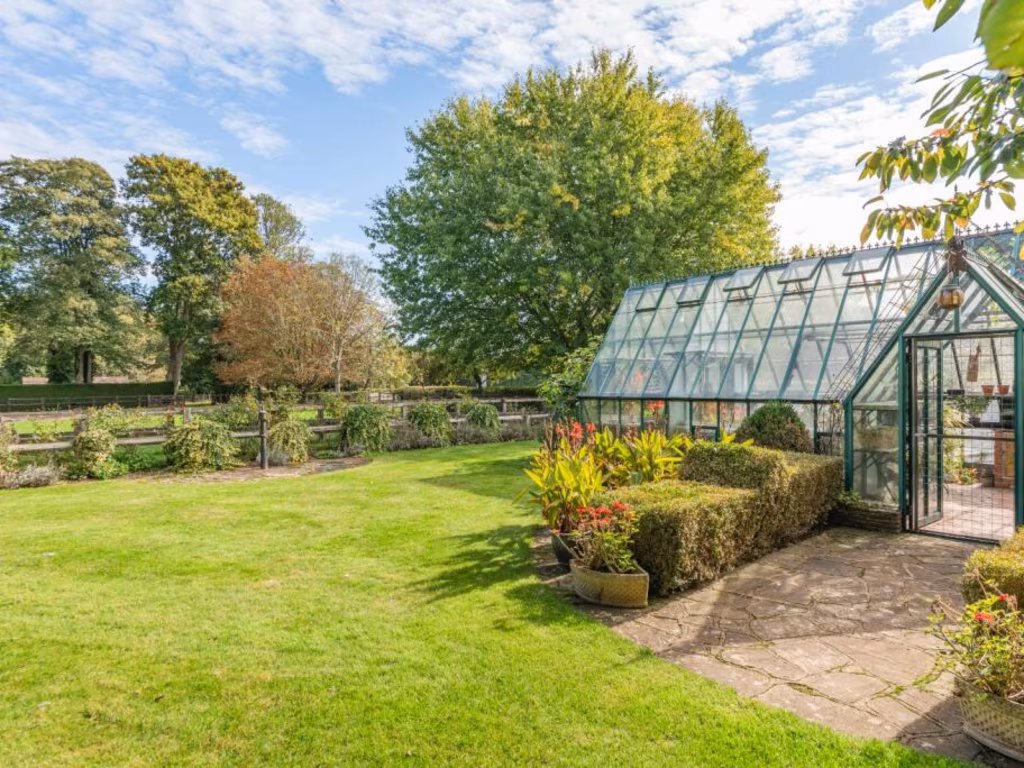
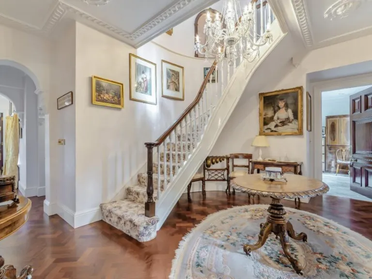
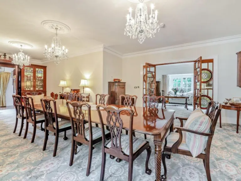
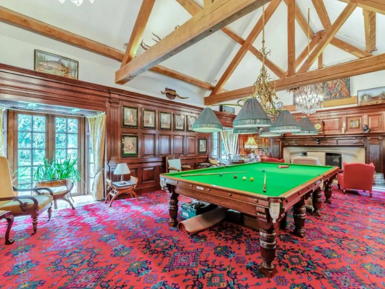
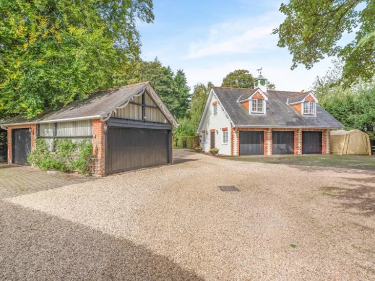
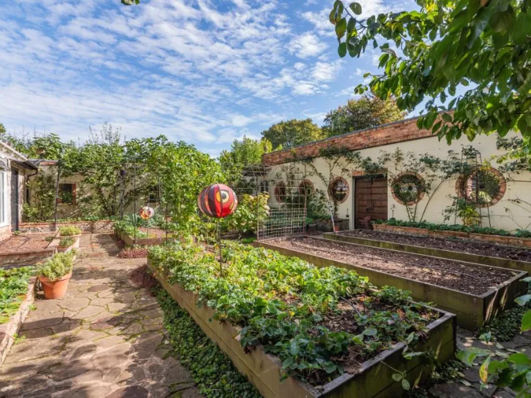
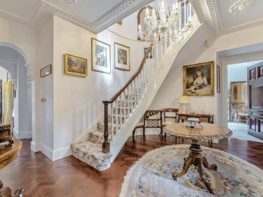
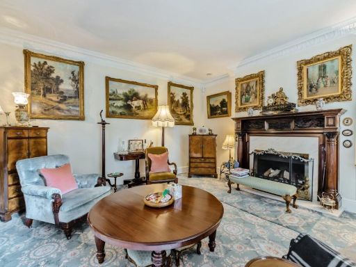
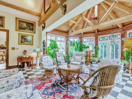
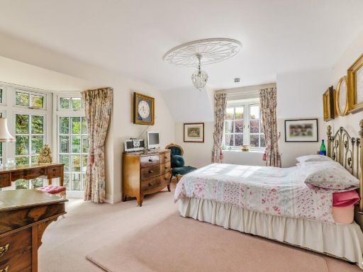
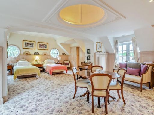
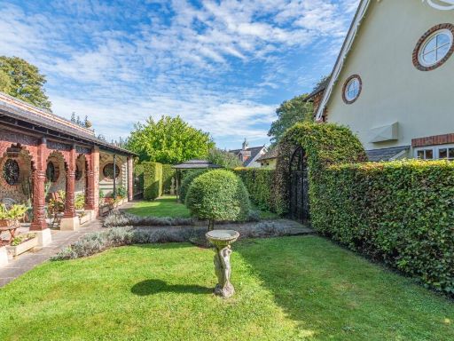
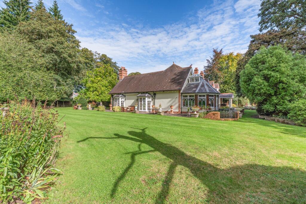
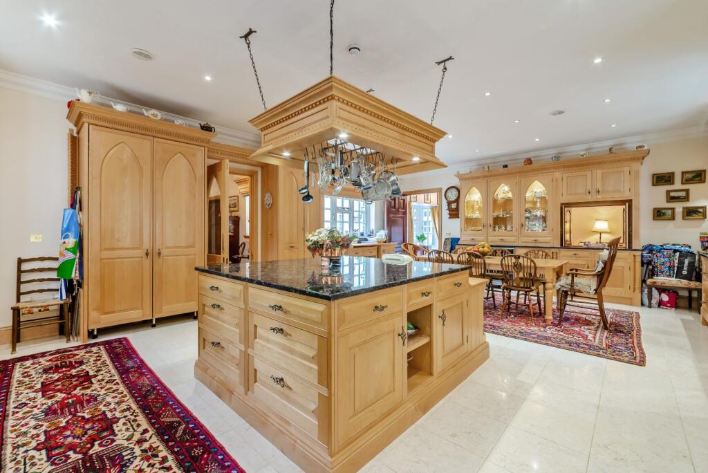
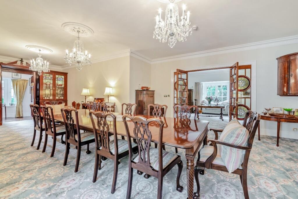
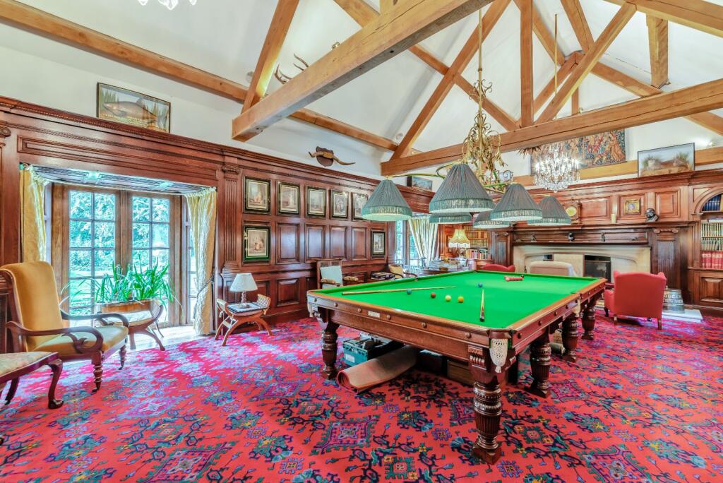
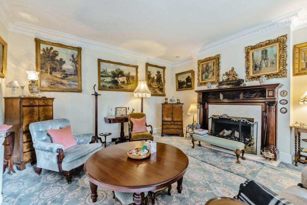
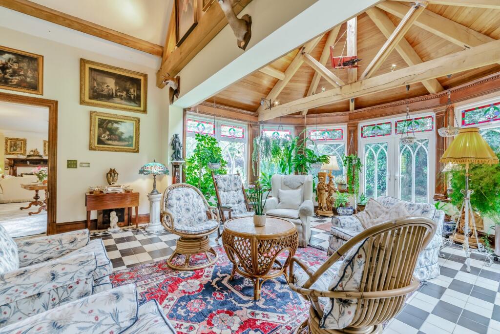
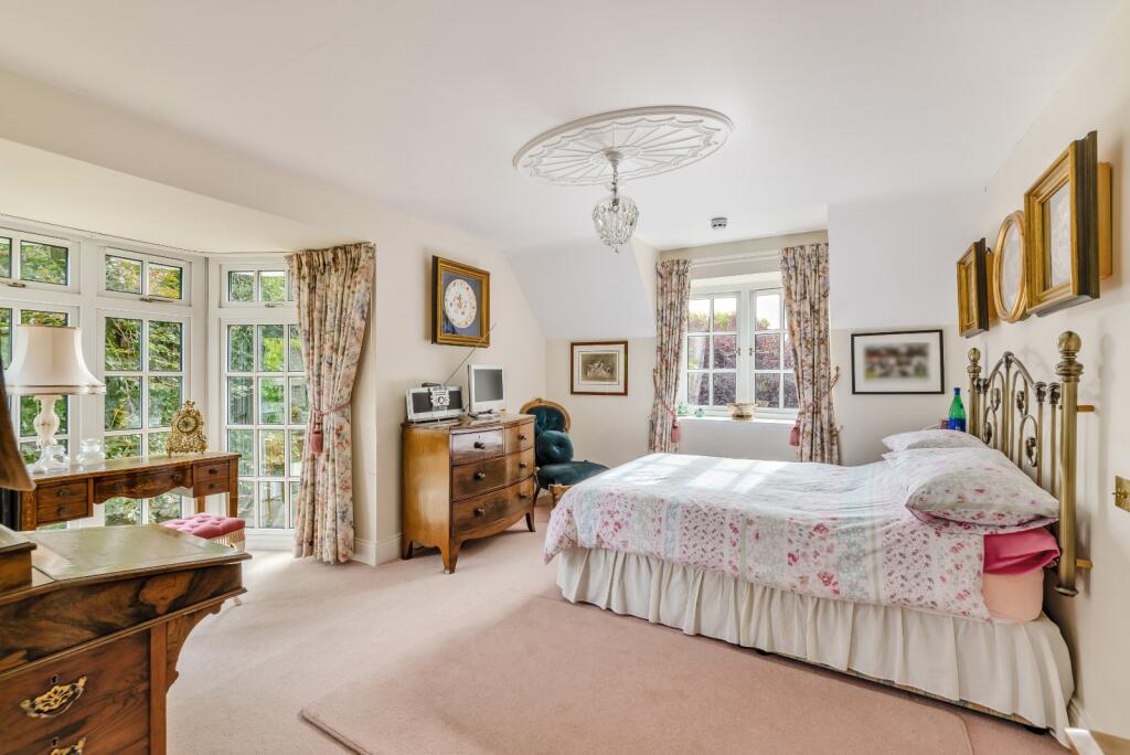
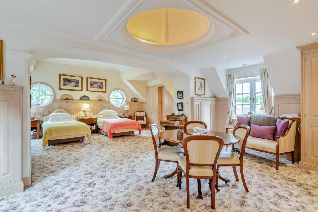
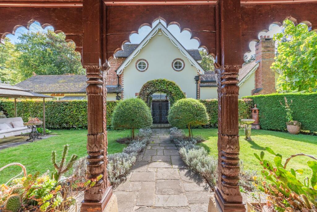
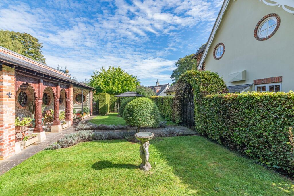
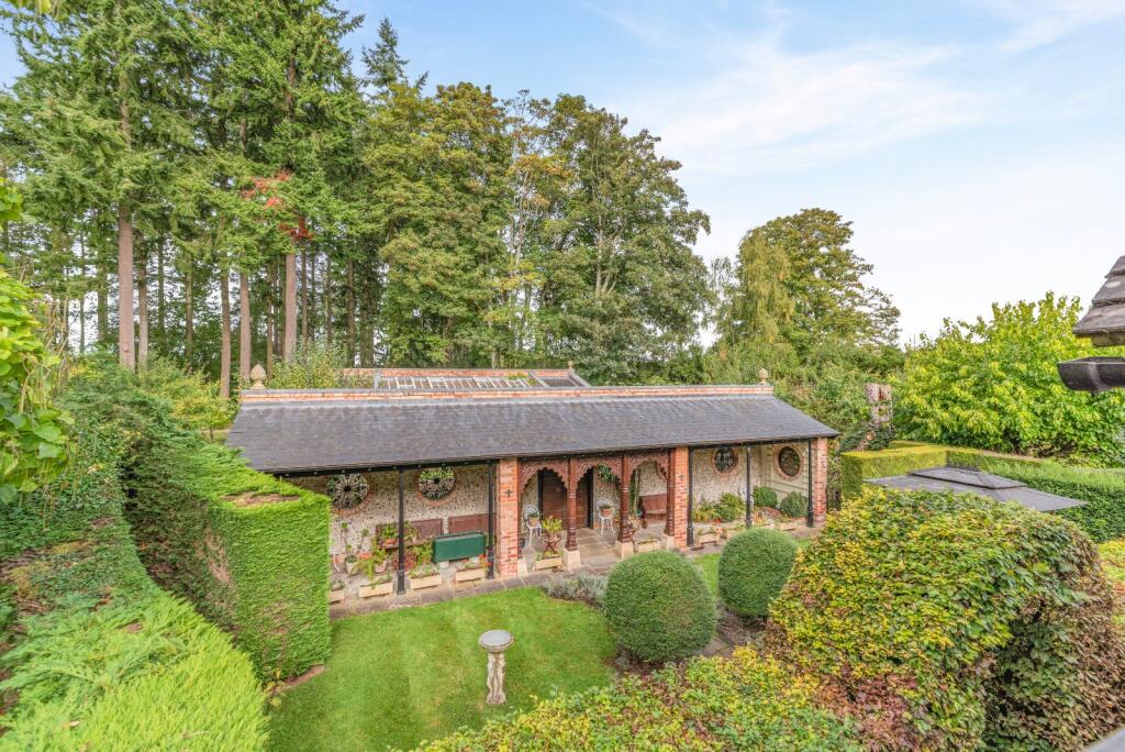
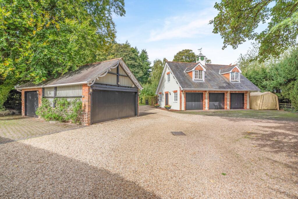
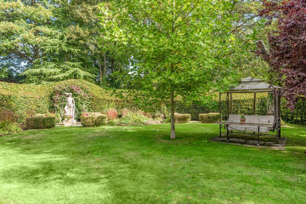
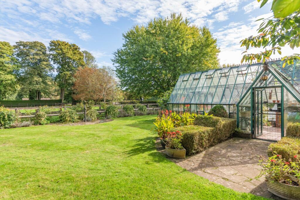
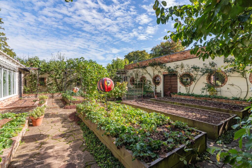
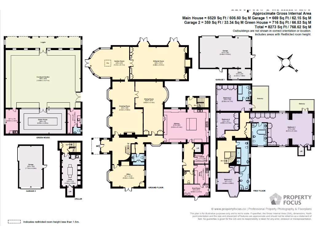
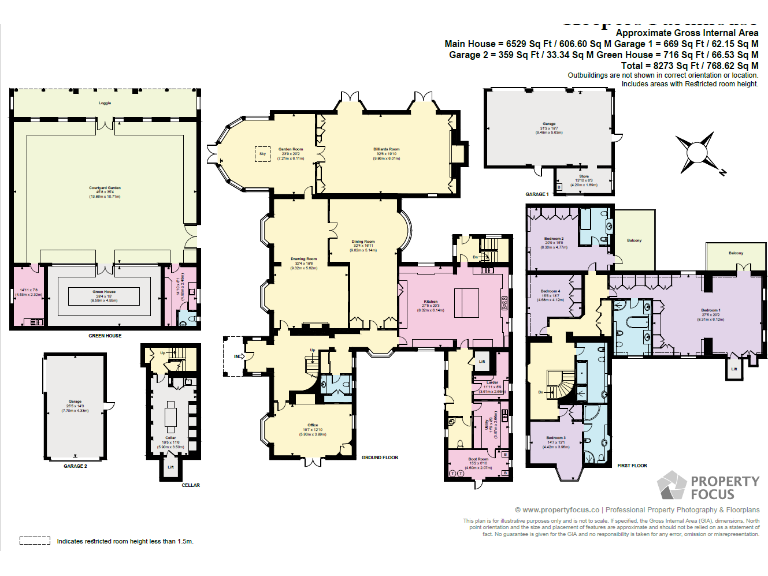
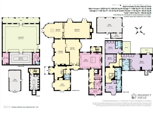
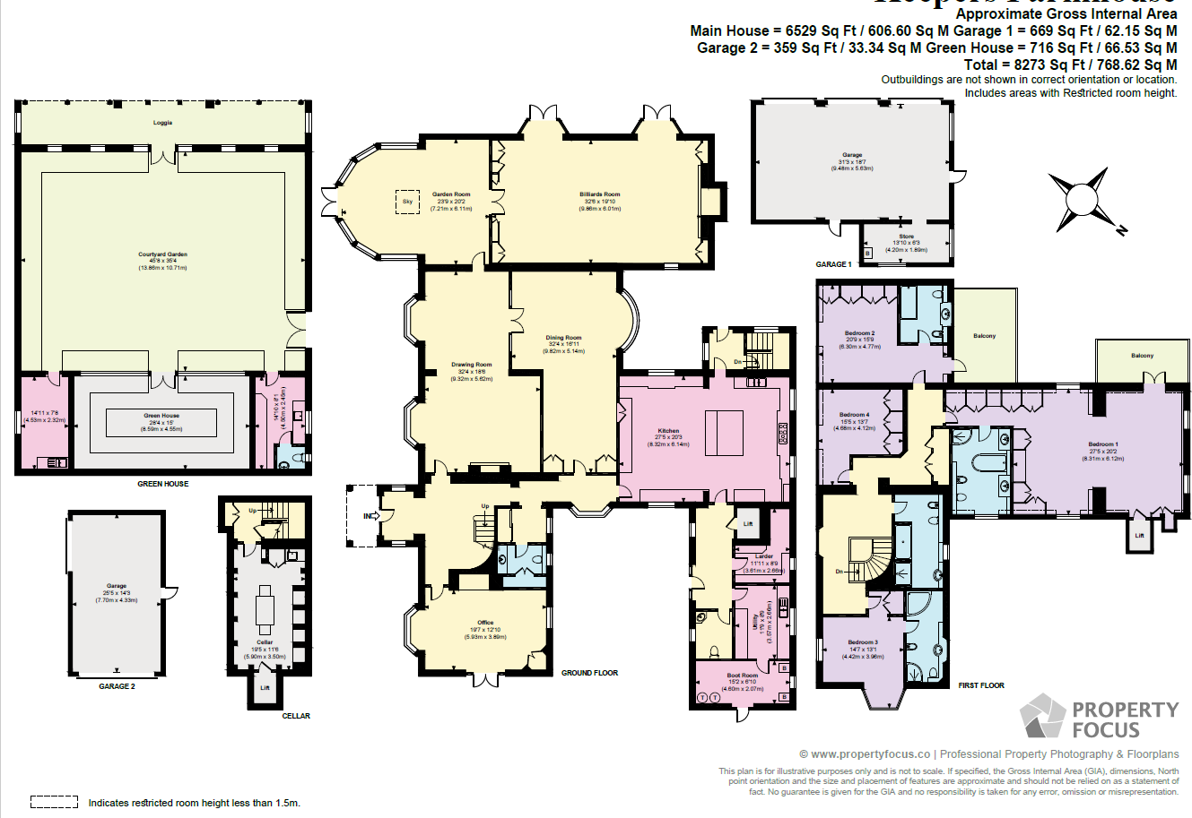
- Substantial period country house set in extensive mature grounds of approximately 15.68 acres. The images show a detached single dwelling (named Keepers House) with large, well-maintained lawns, formal walled garden elements and mature woodland beyond — suggesting a mix of formal garden, pasture and paddock/woodland. The main house presents traditional character features and substantial external footprint with outbuildings/garaging visible (garage with potential 1-bed flat over is noted in the listing). Overall garden size is large; the estate as a whole is very large. The setting is rural and private with extensive amenity land suitable for equestrian, horticultural or recreational use. Internal accommodation described in the listing includes multiple principal reception rooms, a garden room, billiards room, office, utility and cellar, principal bedroom with dressing area and en suite plus further bedrooms and cloakrooms, indicating a high-value family home with considerable usable living space and ancillary accommodation.
Image Descriptions
- front view of house English country house
- detached house Bungalow
Textual Property Features
Detected Visual Features
- English country house
- period property
- character
- spacious
- well-maintained garden
- large garden
- chimneys
- attached extension
- bungalow
- detached
- conservatory
- garden
- chimney
- rural
- single-story
Nearby Schools
- Newton Tony Church of England Voluntary Controlled School
- Anton Junior School
- Balksbury Junior School
- Shipton Bellinger Primary School
- Knights Enham Nursery and Infant School
- Knight's Enham Junior School
- Wallop Primary School
- Farleigh School
- John Hanson Community School
- Rookwood School
- Portway Junior School
- Harrow Way Community School
- Wellington Lions Primary Academy
- The Wellington Academy
- Ludgershall Castle Primary School
- Clatford Church of England Primary School
- Anton Infant School
- Balksbury Infant School
- Clarendon Infants' School
- Clarendon Junior School (Clarendon Federation)
- Appleshaw St Peter's CofE Primary School
- Grateley Primary School
- Abbotts Ann Church of England Primary School
- Amport Church of England Primary School
- St John the Baptist Catholic Primary School, Andover
- Portway Infant School
- Kimpton, Thruxton and Fyfield Church of England Primary School
- Zouch Academy
- Wellington Eagles Primary Academy
Nearest Bars And Restaurants
- Id: 684905690
- Tags:
- Amenity: pub
- Name: Black Swan
- Odbl: clean
- Toilets:
- Wheelchair: limited
- Wikidata: Q26386243
- TagsNormalized:
- Lat: 51.1986501
- Lon: -1.5512788
- FullGeoHash: gcngk8qmu84s
- PartitionGeoHash: gcng
- Images:
- FoodStandards: null
- Distance: 2597.8
,- Id: 5882180102
- Tags:
- Amenity: restaurant
- Cuisine: regional
- Name: Thruxton Centre
- TagsNormalized:
- Lat: 51.2090445
- Lon: -1.6089681
- FullGeoHash: gcng76k6k3f3
- PartitionGeoHash: gcng
- Images:
- FoodStandards: null
- Distance: 2575.9
,- Id: 8231309860
- Tags:
- Amenity: restaurant
- Name: Feathers Restaurant
- TagsNormalized:
- Lat: 51.2078666
- Lon: -1.5615302
- FullGeoHash: gcngk6ngmwnw
- PartitionGeoHash: gcng
- Images:
- FoodStandards: null
- Distance: 2573.8
,- Id: 504667599
- Tags:
- Amenity: pub
- Name: Hawk Inn
- Opening_hours: Mo-Sa 12:00-23:00; Su 12:00-22:30; PH 12:00-22:30
- Opening_hours:kitchen: Mo-Fr 07:30-10:30, 12:00-14:30, 18:30-21:30; Sa 08:30-11:00, 12:00-14:30, 18:30-21:30; Su 08:30-11:00, 12:00-14:30, 18:00-21:00; PH 08:30-11:00, 12:00-14:30, 18:00-21:00
- Toilets: yes
- Toilets:wheelchair: yes
- Wheelchair: yes
- TagsNormalized:
- Lat: 51.1995046
- Lon: -1.5602147
- FullGeoHash: gcngk2xfsr7t
- PartitionGeoHash: gcng
- Images:
- FoodStandards: null
- Distance: 2066.3
,- Id: 226560768
- Tags:
- Addr:
- Postcode: SP11 8JR
- Street: Chapel Lane
- Amenity: pub
- Building: yes
- Name: The Plough Inn
- Website: http://www.ploughinngrateley.co.uk/
- TagsNormalized:
- Lat: 51.1758937
- Lon: -1.6026603
- FullGeoHash: gcng5s2cpq1b
- PartitionGeoHash: gcng
- Images:
- FoodStandards: null
- Distance: 2002.8
}
Nearest General Shops
- Id: 537254788
- Tags:
- Addr:
- City: Abbotts Ann
- Postcode: SP11 7BG
- Street: Duck Street
- Amenity: post_office
- Building: yes
- Name: Abbots Ann Village Shop and Post Office
- TagsNormalized:
- Lat: 51.1905105
- Lon: -1.5310336
- FullGeoHash: gcngjnvnk6f9
- PartitionGeoHash: gcng
- Images:
- FoodStandards: null
- Distance: 3854.8
,- Id: 480033263
- Tags:
- Addr:
- City: Weyhill
- Housename: Rosebourne
- Postcode: SP11 8ED
- Street: Amesbury Road
- Building: yes
- Name: Rosebourne
- Phone: +44 1264 771 714
- Shop: garden_centre
- Toilets:
- Website: https://rosebourne.co.uk/
- Wheelchair: yes
- TagsNormalized:
- Lat: 51.2127693
- Lon: -1.5690722
- FullGeoHash: gcngk712jbnu
- PartitionGeoHash: gcng
- Images:
- FoodStandards: null
- Distance: 2731.1
,- Id: 8231309835
- Tags:
- Name: Hawk Conservancy Trust Gift Shop
- Shop: gift
- TagsNormalized:
- Lat: 51.2080031
- Lon: -1.5614582
- FullGeoHash: gcngk6nuprsk
- PartitionGeoHash: gcng
- Images:
- FoodStandards: null
- Distance: 2588.4
}
Nearest Grocery shops
- Id: 418062506
- Tags:
- Addr:
- City: Weyhill
- Postcode: SP11 0PP
- Street: Weyhill Road
- Area: yes
- Name: Weyhill Farm Shop
- Shop: convenience
- TagsNormalized:
- farm
- farm shop
- shop
- convenience
- Lat: 51.2174413
- Lon: -1.5430153
- FullGeoHash: gcngkgu7jph6
- PartitionGeoHash: gcng
- Images:
- FoodStandards: null
- Distance: 4235.7
,- Id: 418060774
- Tags:
- Addr:
- City: Weyhill
- Housename: Weyhill Service Station
- Postcode: SP11 0PH
- Street: Weyhill Road
- Area: yes
- Brand: Londis
- Brand:wikidata: Q21008564
- Name: Londis
- Shop: convenience
- TagsNormalized:
- Lat: 51.2173102
- Lon: -1.5442601
- FullGeoHash: gcngkggd2ns5
- PartitionGeoHash: gcng
- Images:
- FoodStandards: null
- Distance: 4164
,- Id: 226562947
- Tags:
- Addr:
- Building: yes
- Shop: convenience
- TagsNormalized:
- Lat: 51.1758917
- Lon: -1.6044957
- FullGeoHash: gcng5kr9ht9k
- PartitionGeoHash: gcng
- Images:
- FoodStandards: null
- Distance: 2078.3
}
Nearest Supermarkets
- Id: 423499908
- Tags:
- Addr:
- City: Tidworth
- Country: GB
- Postcode: SP9 7SU
- Street: Pennings Road
- Branch: Tidworth
- Brand: Lidl
- Brand:wikidata: Q151954
- Building: yes
- Fhrs:
- Name: Lidl
- Opening_hours: Mo-Sa 08:00-21:00; Su 10:00-16:00
- Shop: supermarket
- TagsNormalized:
- Lat: 51.2352863
- Lon: -1.6621451
- FullGeoHash: gcng6pjejjwg
- PartitionGeoHash: gcng
- Images:
- FoodStandards:
- Id: 262734
- FHRSID: 262734
- LocalAuthorityBusinessID: PI/000057040
- BusinessName: Lidl Great Britain Limited
- BusinessType: Retailers - supermarkets/hypermarkets
- BusinessTypeID: 7840
- AddressLine1: Lidl
- AddressLine2: Pennings Road
- AddressLine3: Tidworth
- AddressLine4: Wiltshire
- PostCode: SP9 7SU
- RatingValue: 5
- RatingKey: fhrs_5_en-GB
- RatingDate: 2022-08-24
- LocalAuthorityCode: 709
- LocalAuthorityName: Wiltshire
- LocalAuthorityWebSite: http://www.wiltshire.gov.uk
- LocalAuthorityEmailAddress: publicprotectionwest@wiltshire.gov.uk
- Scores:
- Hygiene: 0
- Structural: 0
- ConfidenceInManagement: 0
- NewRatingPending: false
- Geocode:
- Longitude: -1.66353000000000
- Latitude: 51.23594600000000
- Distance: 7241
,- Id: 377436364
- Tags:
- Addr:
- City: Tidworth
- Postcode: SP9 7NR
- Street: Station Road
- Branch: Tidworth Superstore
- Brand: Tesco
- Brand:wikidata: Q487494
- Brand:wikipedia: en:Tesco
- Building: yes
- Contact:
- Website: https://www.tesco.com/store-locator/tidworth/station-rd
- Name: Tesco
- Opening_hours: Mo-Sa 06:00-24:00 Su 10:00-16:00
- Shop: supermarket
- Toilets:
- Wheelchair: yes
- TagsNormalized:
- Lat: 51.2341111
- Lon: -1.6609342
- FullGeoHash: gcng6nys36t9
- PartitionGeoHash: gcng
- Images:
- FoodStandards: null
- Distance: 7090.2
,- Id: 452777952
- Tags:
- Brand: ALDI
- Brand:wikidata: Q41171672
- Brand:wikipedia: en:Aldi
- Building: retail
- Contact:
- Website: https://stores.aldi.co.uk/andover/278-weyhill-road
- Name: ALDI
- Note: alignment approx
- Shop: supermarket
- TagsNormalized:
- aldi
- retail
- supermarket
- shop
- Lat: 51.2111857
- Lon: -1.5130462
- FullGeoHash: gcngmddnz2yv
- PartitionGeoHash: gcng
- Images:
- FoodStandards: null
- Distance: 5591.1
}
Nearest Religious buildings
- Id: 280706005
- Tags:
- Amenity: place_of_worship
- Building: church
- Denomination: anglican
- Name: St Michael and All Angels
- Religion: christian
- Wikidata: Q17539965
- TagsNormalized:
- place of worship
- church
- anglican
- christian
- Lat: 51.1944343
- Lon: -1.6109334
- FullGeoHash: gcng5rdvnw0z
- PartitionGeoHash: gcng
- Images:
- FoodStandards: null
- Distance: 1762.4
,- Id: 280712875
- Tags:
- Addr:
- Postcode: SP11 8BA
- Street: The Green
- Amenity: school
- Capacity: 98
- Denomination: anglican
- Diocese: Diocese of Winchester
- Isced:
- Max_age: 11
- Min_age: 4
- Name: Amport Church of England Primary School
- Phone: +44 1264 772396
- Ref:
- Religion: christian
- School:
- Boarding: no
- Gender: mixed
- Selective: no
- Trust: no
- Type: voluntary_aided
- Website: https://www.amport.hants.sch.uk/
- TagsNormalized:
- school
- anglican
- church
- christian
- Lat: 51.1966902
- Lon: -1.5681759
- FullGeoHash: gcngk2446fg2
- PartitionGeoHash: gcng
- Images:
- FoodStandards: null
- Distance: 1429.6
,- Id: 360731248
- Tags:
- Amenity: place_of_worship
- Building: church
- Denomination: anglican
- Name: St Mary's
- Religion: christian
- Wikidata: Q17535357
- TagsNormalized:
- place of worship
- church
- anglican
- christian
- Lat: 51.1962561
- Lon: -1.572859
- FullGeoHash: gcnghpyxv9z7
- PartitionGeoHash: gcng
- Images:
- FoodStandards: null
- Distance: 1123.5
}
Nearest Medical buildings
- Id: 2443459732
- Tags:
- Amenity: pharmacy
- Brand: Boots
- Brand:wikidata: Q6123139
- Brand:wikipedia: en:Boots UK
- Healthcare: pharmacy
- Name: Boots
- Wheelchair: yes
- TagsNormalized:
- pharmacy
- boots
- health
- healthcare
- Lat: 51.2138018
- Lon: -1.4940239
- FullGeoHash: gcngq50n48x5
- PartitionGeoHash: gcng
- Images:
- FoodStandards: null
- Distance: 6925.4
,- Id: 264443678
- Tags:
- Amenity: doctors
- Building: hospital
- Name: Andover Health Centre
- Opening_hours: Mo 7:30-19:00; Tu-Fr 7:30-18:15
- Wheelchair: yes
- TagsNormalized:
- doctor
- doctors
- hospital
- health
- health centre
- Lat: 51.2150841
- Lon: -1.4954622
- FullGeoHash: gcngmgrj3pws
- PartitionGeoHash: gcng
- Images:
- FoodStandards: null
- Distance: 6887.2
,- Id: 106869277
- Tags:
- Amenity: doctors
- Building: yes
- Name: Charlton Hill Surgery
- TagsNormalized:
- Lat: 51.21604
- Lon: -1.4961691
- FullGeoHash: gcngmgwe09z6
- PartitionGeoHash: gcng
- Images:
- FoodStandards: null
- Distance: 6884.6
,- Id: 8231309870
- Tags:
- Amenity: veterinary
- Name: National Bird of Prey Hospital and Rehabilitation Unit
- TagsNormalized:
- Lat: 51.2077097
- Lon: -1.5615236
- FullGeoHash: gcngk6nftbgw
- PartitionGeoHash: gcng
- Images:
- FoodStandards: null
- Distance: 2561.2
}
Nearest Leisure Facilities
- Id: 506480837
- Tags:
- Landcover: grass
- Landuse: village_green
- Leisure: park
- Name: Thruxton Village Green
- TagsNormalized:
- Lat: 51.2086965
- Lon: -1.5851391
- FullGeoHash: gcng7fm8r8ft
- PartitionGeoHash: gcng
- Images:
- FoodStandards: null
- Distance: 2000.5
,- Id: 226562108
- Tags:
- Leisure: pitch
- Sport: soccer
- TagsNormalized:
- Lat: 51.1770863
- Lon: -1.603898
- FullGeoHash: gcng5s804kqg
- PartitionGeoHash: gcng
- Images:
- FoodStandards: null
- Distance: 1948.1
,- Id: 818453513
- Tags:
- Leisure: pitch
- Sport: soccer
- TagsNormalized:
- Lat: 51.1772844
- Lon: -1.6032917
- FullGeoHash: gcng5s892970
- PartitionGeoHash: gcng
- Images:
- FoodStandards: null
- Distance: 1904.5
,- Id: 815675291
- Tags:
- Leisure: pitch
- Sport: soccer
- TagsNormalized:
- Lat: 51.1973941
- Lon: -1.5671415
- FullGeoHash: gcngk24y6vyx
- PartitionGeoHash: gcng
- Images:
- FoodStandards: null
- Distance: 1530.2
,- Id: 848556991
- Tags:
- Leisure: pitch
- Sport: cricket
- TagsNormalized:
- pitch
- leisure
- cricket
- sports
- Lat: 51.1922884
- Lon: -1.5678814
- FullGeoHash: gcnghr629wnz
- PartitionGeoHash: gcng
- Images:
- FoodStandards: null
- Distance: 1298.6
}
Nearest Tourist attractions
- Id: 508365247
- Tags:
- Addr:
- City: Weyhill
- Country: GB
- Postcode: SP11 8EE
- Street: Wiremead Lane
- Amenity: pub
- Building: yes
- Description: 15th century thatched pub with bed and breakfast accommodation.
- Name: White Horse
- Outdoor_seating: yes
- Phone: +44 1264 772401
- Tourism: guest_house
- Website: http://www.whitehorsethruxton.co.uk/
- Wikidata: Q26450442
- TagsNormalized:
- bar
- pub
- horses
- guest house
- tourism
- Lat: 51.209367
- Lon: -1.5774124
- FullGeoHash: gcngk47k5tuh
- PartitionGeoHash: gcng
- Images:
- FoodStandards: null
- Distance: 2164.7
,- Id: 5072787821
- Tags:
- Name: Appletree Cottage
- Name:en: Appletree Cottage
- Tourism: guest_house
- Wikidata: Q26450663
- TagsNormalized:
- Lat: 51.1936811
- Lon: -1.6121383
- FullGeoHash: gcng5rd0f3yd
- PartitionGeoHash: gcng
- Images:
- FoodStandards: null
- Distance: 1827.2
,- Id: 508460136
- Tags:
- Name: Elmstead Park
- Tourism: caravan_site
- TagsNormalized:
- Lat: 51.205577
- Lon: -1.5780033
- FullGeoHash: gcngk1dyjg7k
- PartitionGeoHash: gcng
- Images:
- FoodStandards: null
- Distance: 1751.2
}
Nearest Train stations
- Id: 6011304341
- Tags:
- Name: Salisbury
- Naptan:
- Network: National Rail
- Public_transport: station
- Railway: station
- Ref:
- Wikidata: Q1976733
- Wikipedia: en:Salisbury railway station
- TagsNormalized:
- Lat: 51.0705706
- Lon: -1.8064141
- FullGeoHash: gcndwchees2h
- PartitionGeoHash: gcnd
- Images:
- FoodStandards: null
- Distance: 20354.6
,- Id: 1136502525
- Tags:
- Name: Whitchurch
- Naptan:
- Network: National Rail
- Operator: South West Trains
- Public_transport: station
- Railway: station
- Ref:
- Source: NPE
- Wikidata: Q1865326
- Wikipedia: en:Whitchurch railway station (Hampshire)
- TagsNormalized:
- Lat: 51.2376461
- Lon: -1.3387418
- FullGeoHash: gcp53x90vj9b
- PartitionGeoHash: gcp5
- Images:
- FoodStandards: null
- Distance: 18018.6
,- Id: 696725
- Tags:
- Name: Mottisfont & Dunbridge
- Naptan:
- Network: National Rail
- Public_transport: station
- Railway: station
- Ref:
- Wikidata: Q6918669
- Wikipedia: en:Mottisfont & Dunbridge railway station
- TagsNormalized:
- Lat: 51.033863
- Lon: -1.5468958
- FullGeoHash: gcnfkf3tf9wf
- PartitionGeoHash: gcnf
- Images:
- FoodStandards: null
- Distance: 17657.9
,- Id: 8089621
- Tags:
- Name: Dean
- Naptan:
- Network: National Rail
- Public_transport: station
- Railway: station
- Ref:
- Wikidata: Q671580
- Wikipedia: en:Dean railway station
- TagsNormalized:
- Lat: 51.0424158
- Lon: -1.634563
- FullGeoHash: gcnf6gcxxgvq
- PartitionGeoHash: gcnf
- Images:
- FoodStandards: null
- Distance: 16830.8
,- Id: 6011146543
- Tags:
- Name: Andover
- Naptan:
- Network: National Rail
- Operator: South West Trains
- Public_transport: station
- Railway: station
- Ref:
- Wikidata: Q2003702
- Wikipedia: en:Andover railway station
- TagsNormalized:
- Lat: 51.211559
- Lon: -1.4927767
- FullGeoHash: gcngq4bbzy90
- PartitionGeoHash: gcng
- Images:
- FoodStandards: null
- Distance: 6918.9
}
Nearest Hotels
- Id: 520393675
- Tags:
- Building: yes
- Name: Gray Manor Hotel
- Source: Bing
- Tourism: hotel
- TagsNormalized:
- Lat: 51.1913918
- Lon: -1.6680071
- FullGeoHash: gcng4p17kx5f
- PartitionGeoHash: gcng
- Images:
- FoodStandards: null
- Distance: 5691.3
,- Id: 597396026
- Tags:
- Brand: Premier Inn
- Brand:wikidata: Q2108626
- Internet_access: wlan
- Internet_access:fee: customers
- Internet_access:operator: Virgin Media
- Internet_access:ssid: Premier Inn Free Wi-Fi
- Name: Premier Inn
- Operator: Premier Inn
- Toilets:
- Tourism: hotel
- Wheelchair: yes
- TagsNormalized:
- Lat: 51.212195
- Lon: -1.5169449
- FullGeoHash: gcngm6zkst5f
- PartitionGeoHash: gcng
- Images:
- FoodStandards: null
- Distance: 5392.9
,- Id: 439401885
- Tags:
- Brand: Travelodge
- Brand:wikidata: Q9361374
- Brand:wikipedia: en:Travelodge UK
- Building: yes
- Internet_access: wlan
- Internet_access:fee: customers
- Internet_access:ssid: Travelodge WiFi
- Name: Travelodge
- Operator: Travelodge
- Tourism: hotel
- TagsNormalized:
- Lat: 51.2106134
- Lon: -1.5211883
- FullGeoHash: gcngm6s73wrb
- PartitionGeoHash: gcng
- Images:
- FoodStandards: null
- Distance: 5050
}
Tags
- English country house
- period property
- character
- spacious
- well-maintained garden
- large garden
- chimneys
- attached extension
- bungalow
- detached
- conservatory
- garden
- chimney
- spacious
- rural
- single-story
Local Market Stats
- Average Price/sqft: £323
- Avg Income: £59100
- Rental Yield: 3.9%
- Social Housing: 10%
- Planning Success Rate: 94%
Similar Properties
 4 bedroom detached house for sale in Amport, Andover, Hampshire, SP11 — £3,250,000 • 4 bed • 3 bath • 8273 ft²
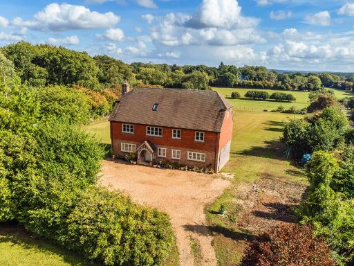 5 bedroom detached house for sale in Blackberry Lane, Four Marks, GU34 — £1,250,000 • 5 bed • 4 bath • 3174 ft²
 7 bedroom detached house for sale in Amport, Andover, Hampshire, SP11 — £2,650,000 • 7 bed • 5 bath • 4597 ft²
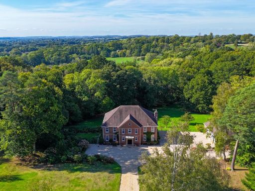 5 bedroom detached house for sale in Danes Road, Awbridge, Romsey, SO51 — £1,950,000 • 5 bed • 4 bath • 5000 ft²
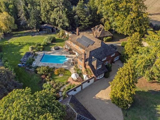 5 bedroom detached house for sale in Upper Enham, Andover, Hampshire, SP11 — £1,695,000 • 5 bed • 3 bath • 6429 ft²
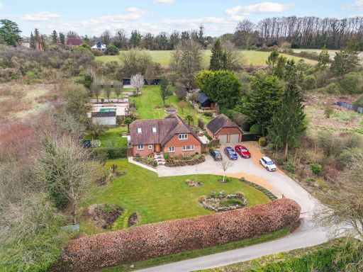 4 bedroom detached house for sale in South Drive, Winchester, SO22 — £1,950,000 • 4 bed • 3 bath • 2311 ft²
Meta
- {
"@context": "https://schema.org",
"@type": "Residence",
"name": "4 bedroom detached house for sale in Amport, Andover, Hamps…",
"description": "",
"url": "https://propertypiper.co.uk/property/c9d29970-4464-4509-8a95-b5f08d4dc5f1",
"image": "https://image-a.propertypiper.co.uk/7aff0578-bd61-40bb-9072-f6c5842a301a-1024.jpeg",
"address": {
"@type": "PostalAddress",
"streetAddress": "Keepers House, Amport, ANDOVER",
"postalCode": "SP11 8BJ",
"addressLocality": "Test Valley",
"addressRegion": "North West Hampshire",
"addressCountry": "England"
},
"geo": {
"@type": "GeoCoordinates",
"latitude": 51.19072137197521,
"longitude": -1.58634706363613
},
"numberOfRooms": 4,
"numberOfBathroomsTotal": 1,
"floorSize": {
"@type": "QuantitativeValue",
"value": 6529,
"unitCode": "FTK"
},
"offers": {
"@type": "Offer",
"price": 3250000,
"priceCurrency": "GBP",
"availability": "https://schema.org/InStock"
},
"additionalProperty": [
{
"@type": "PropertyValue",
"name": "Feature",
"value": "English country house"
},
{
"@type": "PropertyValue",
"name": "Feature",
"value": "period property"
},
{
"@type": "PropertyValue",
"name": "Feature",
"value": "character"
},
{
"@type": "PropertyValue",
"name": "Feature",
"value": "spacious"
},
{
"@type": "PropertyValue",
"name": "Feature",
"value": "well-maintained garden"
},
{
"@type": "PropertyValue",
"name": "Feature",
"value": "large garden"
},
{
"@type": "PropertyValue",
"name": "Feature",
"value": "chimneys"
},
{
"@type": "PropertyValue",
"name": "Feature",
"value": "attached extension"
},
{
"@type": "PropertyValue",
"name": "Feature",
"value": "bungalow"
},
{
"@type": "PropertyValue",
"name": "Feature",
"value": "detached"
},
{
"@type": "PropertyValue",
"name": "Feature",
"value": "conservatory"
},
{
"@type": "PropertyValue",
"name": "Feature",
"value": "garden"
},
{
"@type": "PropertyValue",
"name": "Feature",
"value": "chimney"
},
{
"@type": "PropertyValue",
"name": "Feature",
"value": "spacious"
},
{
"@type": "PropertyValue",
"name": "Feature",
"value": "rural"
},
{
"@type": "PropertyValue",
"name": "Feature",
"value": "single-story"
}
]
}
High Res Floorplan Images
Compatible Floorplan Images
FloorplanImages Thumbnail