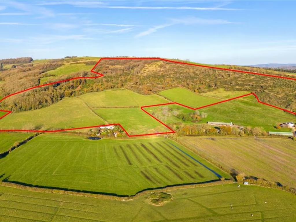
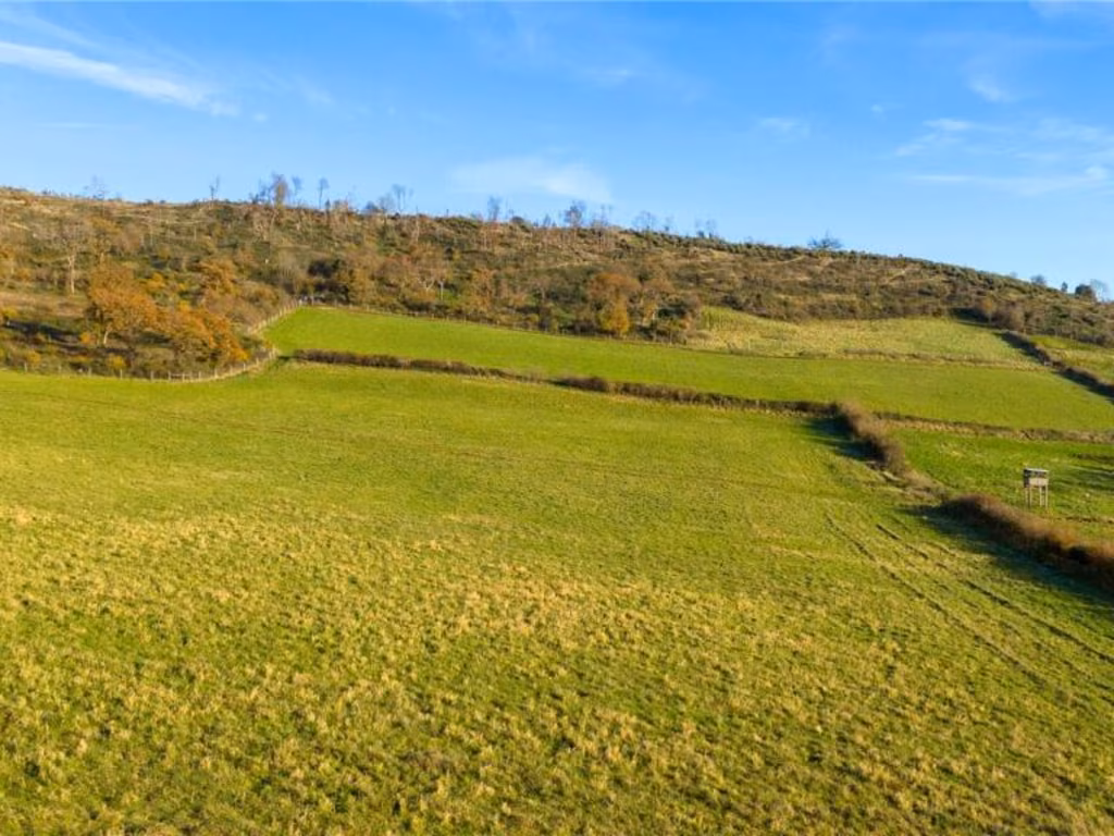
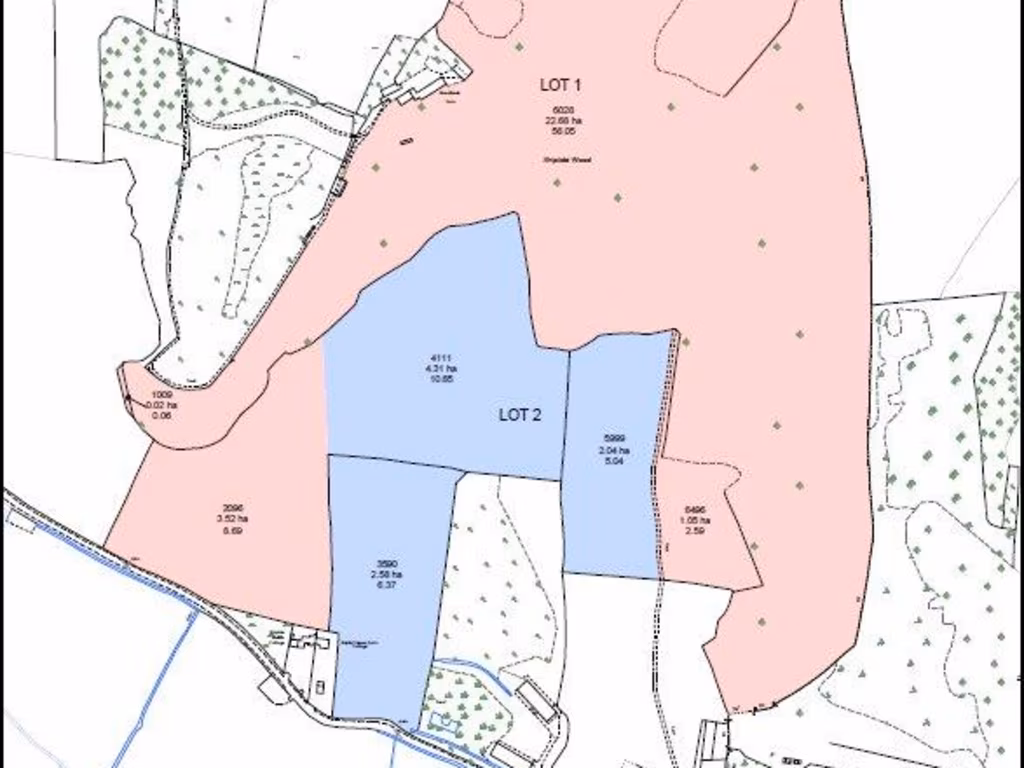
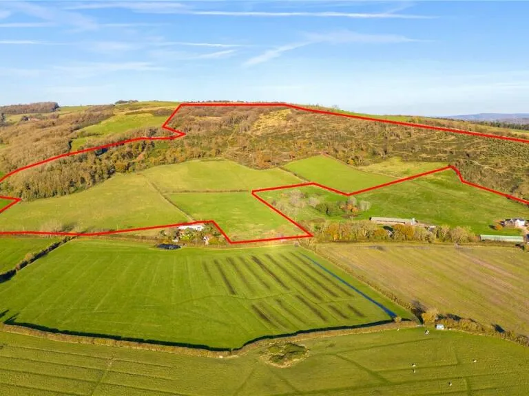
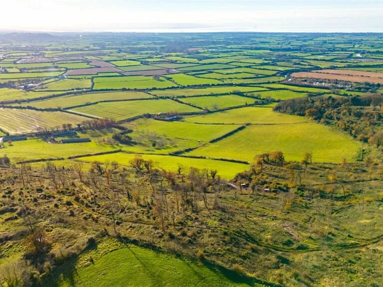
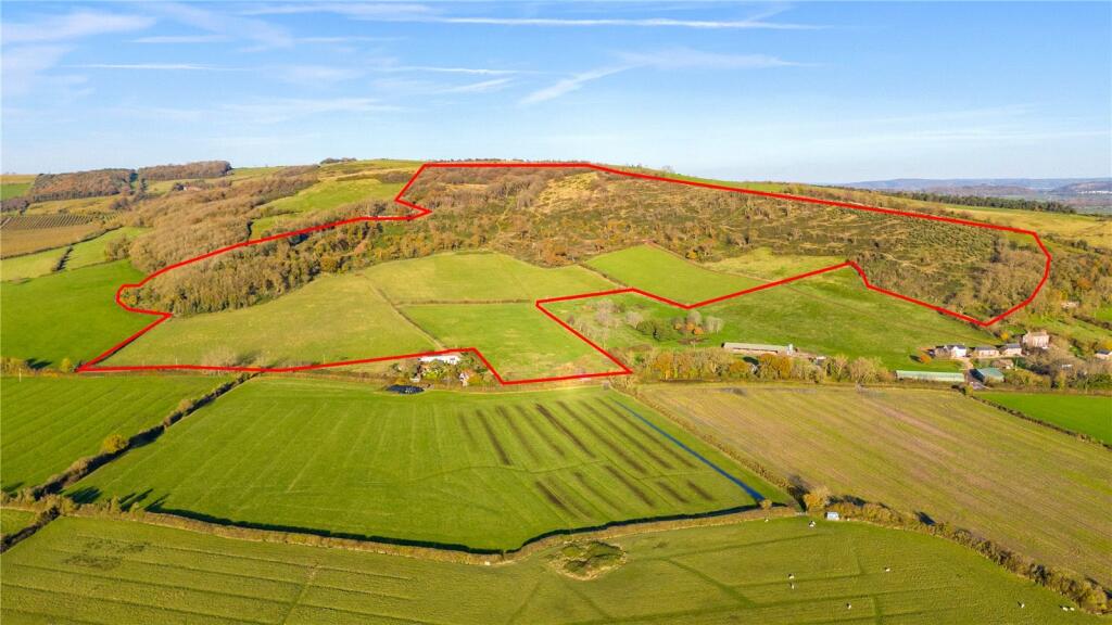
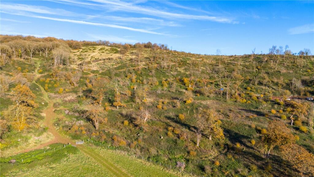
BS26 2XA - Land for sale in Land At Woodlands FarmWhole, Shiplate Road…
View on Property Piper
Land for sale in Land At Woodlands Farm- Whole, Shiplate Road, Loxton, Axbridge, BS26
Property Details
- Price: £650000
- Bedrooms: 1
- Bathrooms: 1
- Property Type: undefined
- Property SubType: undefined
Textual Property Features
Detected Visual Features
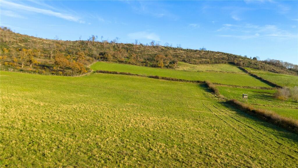
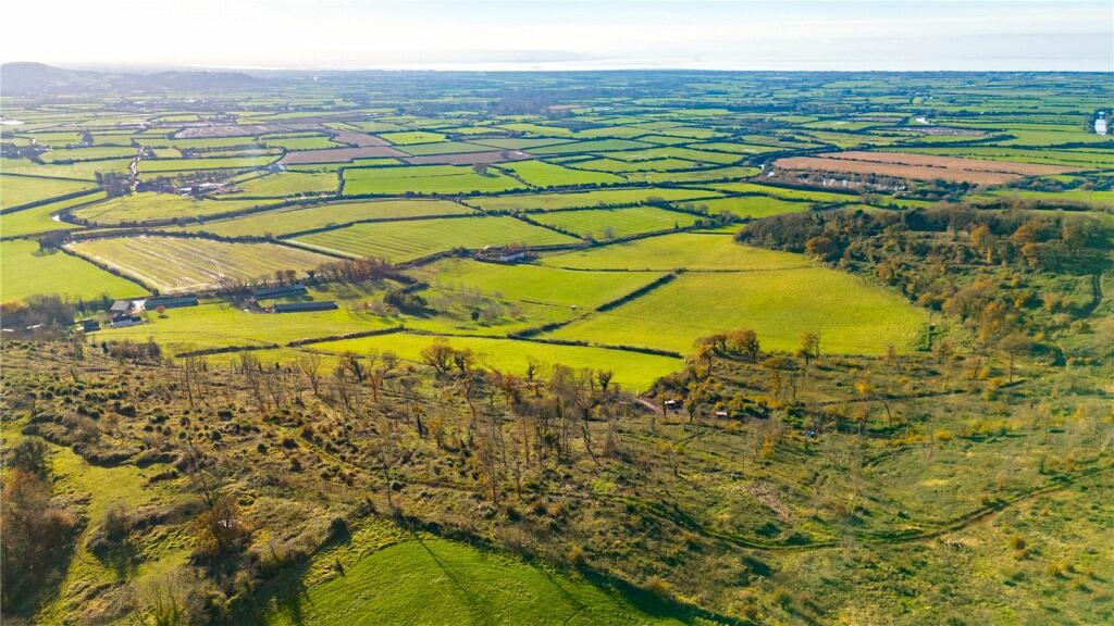
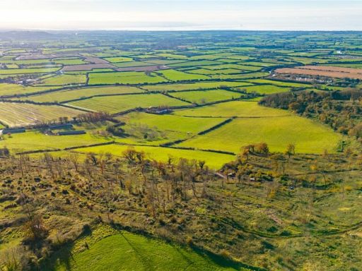
- land
- plot
- farmland
- rural
- expansive
- fields
- development opportunity
- agricultural
- countryside
- property investment
- vacant land
- scenic
- empty
- undeveloped
- nature
- outdoors
Nearby Schools
- Weare Academy First School
- Lympsham Church of England Academy
- Hutton Church of England Primary School
- Worle Community School
- Mendip Green Primary School
- St Martin's Church of England Primary School
- Becket Primary School
- Priory Community School
- East Brent Church of England First School
- Oldmixon Primary School
- Broadoak Academy
- Windwhistle Primary School
- Bournville Primary School
- Winterstoke Hundred Academy
- Ashcombe Primary School
- Mead Vale Community Primary School
- Milton Park Primary School
- Worle Village Primary School
- St Georges Church School
- Locking Primary School
- Parklands Educate Together Primary
- Haywood Village Academy
- Hans Price Academy
- St Anne's Church Academy
- Brent Knoll Church of England Primary School
- Banwell Primary School
- Herons' Moor Academy
- St Mark's Ecumenical Anglican/Methodist Primary School
Nearest General Shops
- Id: 9995391312
- Tags:
- Name: The Cornish Bakery
- Shop: bakery
- TagsNormalized:
- Lat: 51.2692924
- Lon: -2.9194937
- FullGeoHash: gcjgtt616bg9
- PartitionGeoHash: gcjg
- Images:
- FoodStandards: null
- Distance: 3146.1
,- Id: 9995391316
- Tags:
- Name: New York Bakery Co
- Shop: bakery
- TagsNormalized:
- Lat: 51.2692979
- Lon: -2.9193813
- FullGeoHash: gcjgtt61m3zd
- PartitionGeoHash: gcjg
- Images:
- FoodStandards: null
- Distance: 3144
,- Id: 671794369
- Tags:
- Addr:
- City: Lympsham
- Housename: Carbase
- Postcode: BS24 0JN
- Street: Bridgwater Road
- Brand: Carbase
- Fixme: payment:No_Deposit = yes payment:Pay_Monthly = yes
- Name: Carbase Lympsham
- Payment:
- Financing: yes
- Mastercard: yes
- Visa: yes
- Second_hand: yes
- Service:
- Vehicle:
- Car_repair: yes
- New_car_sales: yes
- Used_car_sales: yes
- Shop: car
- TagsNormalized:
- Lat: 51.2816701
- Lon: -2.9357652
- FullGeoHash: gcjgtpw1rsnv
- PartitionGeoHash: gcjg
- Images:
- FoodStandards: null
- Distance: 2437.1
}
Nearest Grocery shops
- Id: 9381624567
- Tags:
- TagsNormalized:
- Lat: 51.285031
- Lon: -2.9538283
- FullGeoHash: gcjgub1hfy9y
- PartitionGeoHash: gcjg
- Images:
- FoodStandards: null
- Distance: 3276.7
,- Id: 9995391313
- Tags:
- Brand: Spar
- Brand:wikidata: Q610492
- Name: Spar
- Shop: convenience
- TagsNormalized:
- Lat: 51.2692869
- Lon: -2.91908
- FullGeoHash: gcjgtt63hxb1
- PartitionGeoHash: gcjg
- Images:
- FoodStandards: null
- Distance: 3141.3
,- Id: 9381554928
- Tags:
- TagsNormalized:
- Lat: 51.2890905
- Lon: -2.9459587
- FullGeoHash: gcjgubyud5my
- PartitionGeoHash: gcjg
- Images:
- FoodStandards: null
- Distance: 2599.7
}
Nearest Religious buildings
- Id: 879310528
- Tags:
- Amenity: place_of_worship
- Building: church
- Denomination: anglican
- Name: St Peter & St Paul
- Religion: christian
- Wikidata: Q5117699
- Wikipedia: en:Church of St Peter & St Paul, Bleadon
- TagsNormalized:
- place of worship
- church
- anglican
- paul
- christian
- Lat: 51.3074713
- Lon: -2.9461872
- FullGeoHash: gcjguunxsvge
- PartitionGeoHash: gcjg
- Images:
- FoodStandards: null
- Distance: 2718.2
,- Id: 589927255
- Tags:
- Addr:
- City: Axbridge
- Country: GB
- County: Somerset
- Hamlet: Christon
- Housename: Christon Church
- Postcode: BS26 2XX
- Street: Banwell Road
- Amenity: place_of_worship
- Building: yes
- Denomination: anglican
- Name: The Blessed Virgin Mary
- Religion: christian
- Wikidata: Q5117509
- Wikipedia: en:St Mary's Church, Christon
- TagsNormalized:
- place of worship
- anglican
- christian
- church
- Lat: 51.3113176
- Lon: -2.8915429
- FullGeoHash: gcjgyhyqn4v7
- PartitionGeoHash: gcjg
- Images:
- FoodStandards: null
- Distance: 2075.5
,- Id: 127440130
- Tags:
- Amenity: place_of_worship
- Building: church
- Denomination: anglican
- Name: St Andrew
- Religion: christian
- Wikidata: Q17534499
- TagsNormalized:
- place of worship
- church
- anglican
- christian
- Lat: 51.2981313
- Lon: -2.8960782
- FullGeoHash: gcjgy4e1k2z8
- PartitionGeoHash: gcjg
- Images:
- FoodStandards: null
- Distance: 1031.2
}
Nearest Medical buildings
- Id: 1890106714
- Tags:
- TagsNormalized:
- Lat: 51.3282802
- Lon: -2.8703841
- FullGeoHash: gcjun8jbghym
- PartitionGeoHash: gcju
- Images:
- FoodStandards: null
- Distance: 4466.2
,- Id: 1890106765
- Tags:
- TagsNormalized:
- Lat: 51.3281654
- Lon: -2.8703405
- FullGeoHash: gcjun8jbhpwb
- PartitionGeoHash: gcju
- Images:
- FoodStandards: null
- Distance: 4458.2
,- Id: 1125678035
- Tags:
- Addr:
- City: Highbridge
- Country: GB
- County: Somerset
- Postcode: TA9 4JD
- Street: Brent Road
- Village: East Brent
- Amenity: doctors
- Building: yes
- Healthcare: doctor
- Name: Brent Area Medical Centre
- Opening_hours: Mo-Th 08:30-18:15; Fr 08:00-20:00
- Phone: +44 1278 760313
- TagsNormalized:
- doctor
- doctors
- health
- healthcare
- Lat: 51.2637167
- Lon: -2.9362006
- FullGeoHash: gcjgthmbv96j
- PartitionGeoHash: gcjg
- Images:
- FoodStandards: null
- Distance: 4106.7
,- Id: 245062739
- Tags:
- Addr:
- Housenumber: 60
- Street: Grenville Avenue
- Amenity: pharmacy
- Building: yes
- Name: Locking Pharmacy
- Source: Bing
- Source:amenity: Survey
- Source:name: Survey
- TagsNormalized:
- Lat: 51.3333457
- Lon: -2.9141521
- FullGeoHash: gcjuj8vyrm4w
- PartitionGeoHash: gcju
- Images:
- FoodStandards: null
- Distance: 4041.5
}
Nearest Airports
- Id: 47483196
- Tags:
- Aerodrome: international
- Aeroway: aerodrome
- Iata: BRS
- Icao: EGGD
- Internet_access: wlan
- Internet_access:fee: no
- Name: Bristol Airport
- Type: public
- Website: https://www.bristolairport.co.uk/
- Wikidata: Q8725
- Wikipedia: en:Bristol Airport
- TagsNormalized:
- airport
- international airport
- Lat: 51.3830799
- Lon: -2.7186615
- FullGeoHash: gcnh64h24s74
- PartitionGeoHash: gcnh
- Images:
- FoodStandards: null
- Distance: 16420.7
,- Id: 319112968
- Tags:
- Aerodrome: international
- Aerodrome:type: public
- Aeroway: aerodrome
- Iata: CWL
- Icao: EGFF
- Internet_access: yes
- Internet_access:fee: no
- Is_in: Cardiff,Wales,UK
- Name: Cardiff Airport
- Operator: Cardiff International Airport Limited
- Source: Gagravarr_Airports
- Type: civil
- Wikidata: Q8994
- Wikipedia: en:Cardiff Airport
- TagsNormalized:
- airport
- international airport
- Lat: 51.3978554
- Lon: -3.3438203
- FullGeoHash: gcjs7utn5qdy
- PartitionGeoHash: gcjs
- Images:
- FoodStandards: null
- Distance: 32093.9
}
Nearest Leisure Facilities
- Id: 9995391305
- Tags:
- Leisure: amusement_arcade
- Name: Jackpot 500
- TagsNormalized:
- Lat: 51.269031
- Lon: -2.9194415
- FullGeoHash: gcjgtt4pu04d
- PartitionGeoHash: gcjg
- Images:
- FoodStandards: null
- Distance: 3173.9
,- Id: 9842801921
- Tags:
- TagsNormalized:
- picnic
- picnic table
- leisure
- Lat: 51.2693568
- Lon: -2.9189744
- FullGeoHash: gcjgtt63wuyf
- PartitionGeoHash: gcjg
- Images:
- FoodStandards: null
- Distance: 3132.3
,- Id: 329001289
- Tags:
- Description: 9 hole Par 35
- Golf:
- Leisure: golf_course
- Name: Bleadon Hill Golf Course
- Phone: +44 1934 811777
- Source: Bing
- Website: https://www.bleadonhillgolfcourse.co.uk/
- TagsNormalized:
- Lat: 51.3164822
- Lon: -2.9430861
- FullGeoHash: gcjgvjbujjeg
- PartitionGeoHash: gcjg
- Images:
- FoodStandards: null
- Distance: 3114.1
,- Id: 1030745004
- Tags:
- Leisure: pitch
- Sport: tennis
- TagsNormalized:
- Lat: 51.2959507
- Lon: -2.8668667
- FullGeoHash: gcjgyf0kt4m2
- PartitionGeoHash: gcjg
- Images:
- FoodStandards: null
- Distance: 3057.9
,- Id: 116546491
- Tags:
- Leisure: swimming_pool
- Source: Bing
- TagsNormalized:
- swimming
- swimming pool
- pool
- leisure
- Lat: 51.3147438
- Lon: -2.9357486
- FullGeoHash: gcjgvjw601e4
- PartitionGeoHash: gcjg
- Images:
- FoodStandards: null
- Distance: 2621.4
}
Nearest Tourist attractions
- Id: 355180430
- Tags:
- Addr:
- Housenumber: 30
- Street: Main Road
- Building: house
- Guest_house: bed_and_breakfast
- Name: Moorlands B&B
- Source: Bing
- Tourism: guest_house
- TagsNormalized:
- Lat: 51.3241433
- Lon: -2.9326251
- FullGeoHash: gcjgvr28bcu0
- PartitionGeoHash: gcjg
- Images:
- FoodStandards: null
- Distance: 3371.7
,- Id: 894286446
- Tags:
- Area: yes
- Tourism: caravan_site
- TagsNormalized:
- Lat: 51.2741094
- Lon: -2.9363423
- FullGeoHash: gcjgtnjv66b2
- PartitionGeoHash: gcjg
- Images:
- FoodStandards: null
- Distance: 3108.9
,- Id: 691368104
- Tags:
- Name: Webbington Farm
- Source: OS OpenData StreetView
- Tourism: museum
- TagsNormalized:
- Lat: 51.2953269
- Lon: -2.8919346
- FullGeoHash: gcjgy4n0vjcr
- PartitionGeoHash: gcjg
- Images:
- FoodStandards: null
- Distance: 1326.5
}
Nearest Train stations
- Id: 21277558
- Tags:
- Name: Yatton
- Naptan:
- Network: National Rail
- Operator: GWR
- Platforms: 2
- Public_transport: station
- Railway: station
- Ref:
- Source: NPE + GPX
- Wikidata: Q1957149
- Wikipedia: en:Yatton railway station
- TagsNormalized:
- Lat: 51.3908826
- Lon: -2.8277046
- FullGeoHash: gcjurekvtdye
- PartitionGeoHash: gcju
- Images:
- FoodStandards: null
- Distance: 11923.1
,- Id: 474564204
- Tags:
- Name: Highbridge and Burnham
- Naptan:
- Network: National Rail
- Public_transport: station
- Railway: station
- Ref:
- Wikidata: Q2508684
- Wikipedia: en:Highbridge and Burnham railway station
- TagsNormalized:
- Lat: 51.2183132
- Lon: -2.9720037
- FullGeoHash: gcjgkk5b7397
- PartitionGeoHash: gcjg
- Images:
- FoodStandards: null
- Distance: 9736.7
,- Id: 21277582
- Tags:
- Name: Weston-super-Mare
- Naptan:
- Network: National Rail
- Public_transport: station
- Railway: station
- Ref:
- Source: NPE
- Wikidata: Q2335883
- Wikipedia: en:Weston-super-Mare railway station
- TagsNormalized:
- Lat: 51.344496
- Lon: -2.9718305
- FullGeoHash: gcjuh6gzr7f8
- PartitionGeoHash: gcju
- Images:
- FoodStandards: null
- Distance: 6767.8
,- Id: 253893851
- Tags:
- Name: Worle
- Naptan:
- Network: National Rail
- Public_transport: station
- Railway: station
- Ref:
- Wikidata: Q2416797
- Wikipedia: en:Worle railway station
- TagsNormalized:
- Lat: 51.3578502
- Lon: -2.9093225
- FullGeoHash: gcjujv3mpv5v
- PartitionGeoHash: gcju
- Images:
- FoodStandards: null
- Distance: 6760.4
,- Id: 21277557
- Tags:
- Name: Weston Milton
- Naptan:
- Network: National Rail
- Operator: GWR
- Public_transport: station
- Railway: station
- Ref:
- Source: NPE + GPX
- Wikidata: Q2432877
- Wikipedia: en:Weston Milton railway station
- TagsNormalized:
- Lat: 51.3485177
- Lon: -2.9422803
- FullGeoHash: gcjuj59qzckz
- PartitionGeoHash: gcju
- Images:
- FoodStandards: null
- Distance: 6125.5
}
Nearest Hotels
- Id: 69029575
- Tags:
- Addr:
- City: Bristol
- Postcode: BS24 0JL
- Brand: Days Inn
- Brand:wikidata: Q1047239
- Building: yes
- Name: Days Inn
- Operator: Welcome Break
- Tourism: hotel
- TagsNormalized:
- Lat: 51.2688337
- Lon: -2.9240666
- FullGeoHash: gcjgtmny873c
- PartitionGeoHash: gcjg
- Images:
- FoodStandards: null
- Distance: 3271.2
,- Id: 121636016
- Tags:
- Amenity: parking
- Name: Hotel Parking
- Parking: surface
- TagsNormalized:
- Lat: 51.2689896
- Lon: -2.923867
- FullGeoHash: gcjgtmnzsbqe
- PartitionGeoHash: gcjg
- Images:
- FoodStandards: null
- Distance: 3250.7
,- Id: 4437535490
- Tags:
- Name: Cutoff
- Name:en: Cutoff
- Tourism: hotel
- TagsNormalized:
- Lat: 51.3030726
- Lon: -2.9223671
- FullGeoHash: gcjgv7rypcvh
- PartitionGeoHash: gcjg
- Images:
- FoodStandards: null
- Distance: 1045.2
}
Tags
- land
- plot
- farmland
- rural
- expansive
- fields
- development opportunity
- agricultural
- countryside
- property investment
- vacant land
- development opportunity
- rural
- countryside
- scenic
- empty
- undeveloped
- nature
- outdoors
Local Market Stats
- Average Price/sqft: £308
- Avg Income: £50600
- Social Housing: 3%
- Planning Success Rate: 88%
Similar Properties
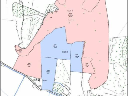
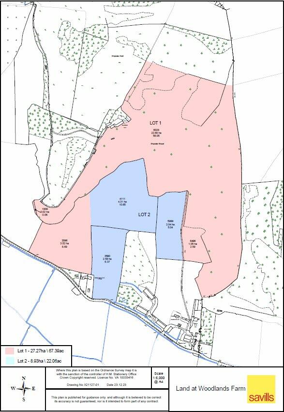
 Land for sale in Shiplate Road, Loxton, Axbridge, Somerset, BS26 — £650,000 • 1 bed • 1 bath
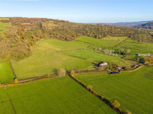 Land for sale in Land At Woodlands Farm- Lot 1, Shiplate Road, Loxton, Axbridge, BS26 — £420,000 • 1 bed • 1 bath
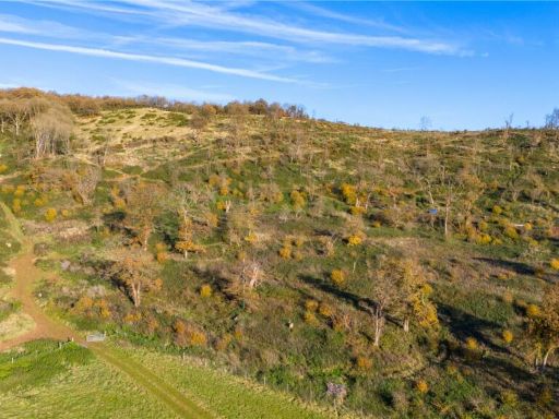 Land for sale in Shiplate Road, Loxton, Axbridge, Somerset, BS26 — £420,000 • 1 bed • 1 bath
 Land for sale in Land At Woodlands Farm- Lot 2, Shiplate Road, Loxton, Axbridge, BS26 — £230,000 • 1 bed • 1 bath
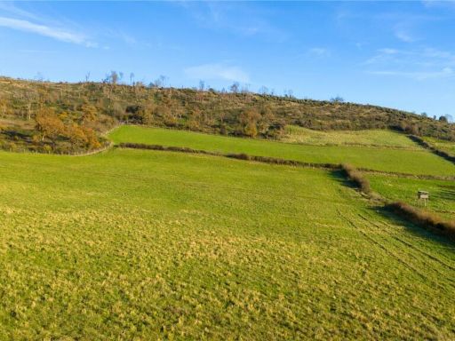 Land for sale in Shiplate Road, Loxton, Axbridge, Somerset, BS26 — £230,000 • 1 bed • 1 bath
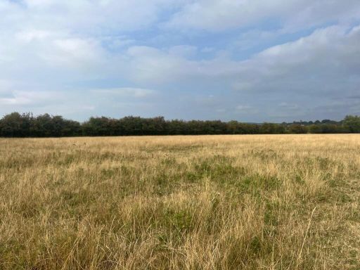 Land for sale in The Doles, Badgworth, Axbridge, Somerset, BS26 — £140,000 • 1 bed • 1 bath
Meta
- {
"@context": "https://schema.org",
"@type": "Residence",
"name": "Land for sale in Land At Woodlands FarmWhole, Shiplate Road…",
"description": "",
"url": "https://propertypiper.co.uk/property/c9314c40-61b6-41f6-aef4-346c2e9e2baf",
"image": "https://image-a.propertypiper.co.uk/c8679d3b-a25a-4bd2-9b64-9eca608cfe58-1024.jpeg",
"address": {
"@type": "PostalAddress",
"streetAddress": "Land At Woodlands Farm- Whole, Shiplate Road, Loxton, Axbridge, BS26",
"postalCode": "BS26 2XA",
"addressLocality": "North Somerset",
"addressRegion": "Weston-Super-Mare",
"addressCountry": "England"
},
"geo": {
"@type": "GeoCoordinates",
"latitude": 51.29705968015699,
"longitude": -2.9108109271190754
},
"numberOfRooms": 1,
"numberOfBathroomsTotal": 1,
"offers": {
"@type": "Offer",
"price": 650000,
"priceCurrency": "GBP",
"availability": "https://schema.org/InStock"
},
"additionalProperty": [
{
"@type": "PropertyValue",
"name": "Feature",
"value": "land"
},
{
"@type": "PropertyValue",
"name": "Feature",
"value": "plot"
},
{
"@type": "PropertyValue",
"name": "Feature",
"value": "farmland"
},
{
"@type": "PropertyValue",
"name": "Feature",
"value": "rural"
},
{
"@type": "PropertyValue",
"name": "Feature",
"value": "expansive"
},
{
"@type": "PropertyValue",
"name": "Feature",
"value": "fields"
},
{
"@type": "PropertyValue",
"name": "Feature",
"value": "development opportunity"
},
{
"@type": "PropertyValue",
"name": "Feature",
"value": "agricultural"
},
{
"@type": "PropertyValue",
"name": "Feature",
"value": "countryside"
},
{
"@type": "PropertyValue",
"name": "Feature",
"value": "property investment"
},
{
"@type": "PropertyValue",
"name": "Feature",
"value": "vacant land"
},
{
"@type": "PropertyValue",
"name": "Feature",
"value": "development opportunity"
},
{
"@type": "PropertyValue",
"name": "Feature",
"value": "rural"
},
{
"@type": "PropertyValue",
"name": "Feature",
"value": "countryside"
},
{
"@type": "PropertyValue",
"name": "Feature",
"value": "scenic"
},
{
"@type": "PropertyValue",
"name": "Feature",
"value": "empty"
},
{
"@type": "PropertyValue",
"name": "Feature",
"value": "undeveloped"
},
{
"@type": "PropertyValue",
"name": "Feature",
"value": "nature"
},
{
"@type": "PropertyValue",
"name": "Feature",
"value": "outdoors"
}
]
}