HP9 1XR - 2 bedroom semidetached house for sale in Gomms Wood Close,…
View on Property Piper
2 bedroom semi-detached house for sale in Gomms Wood Close, Forty Green, Beaconsfield, Buckinghamshire, HP9
Property Details
- Price: £535000
- Bedrooms: 2
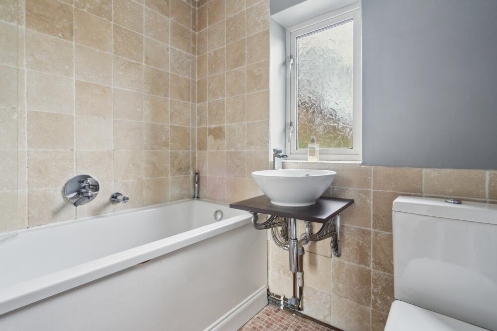
- Bathrooms: 1
- Property Type: undefined
- Property SubType: undefined
Brochure Descriptions
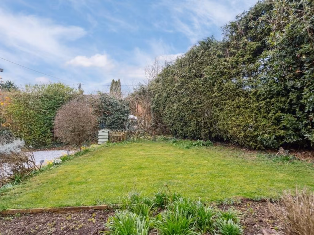
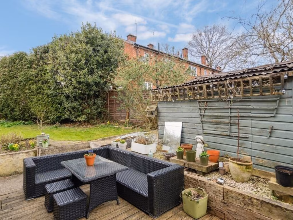
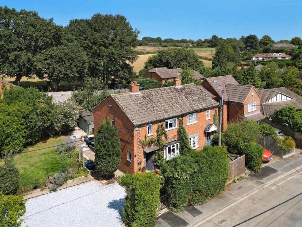
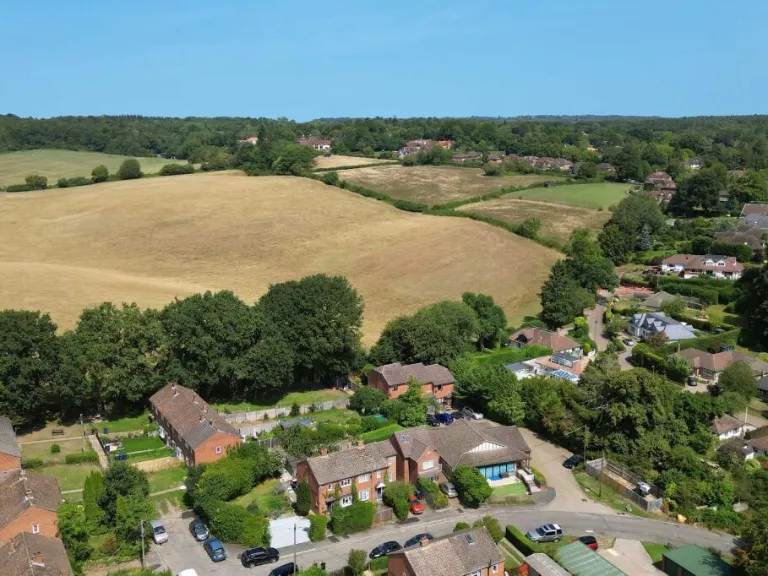
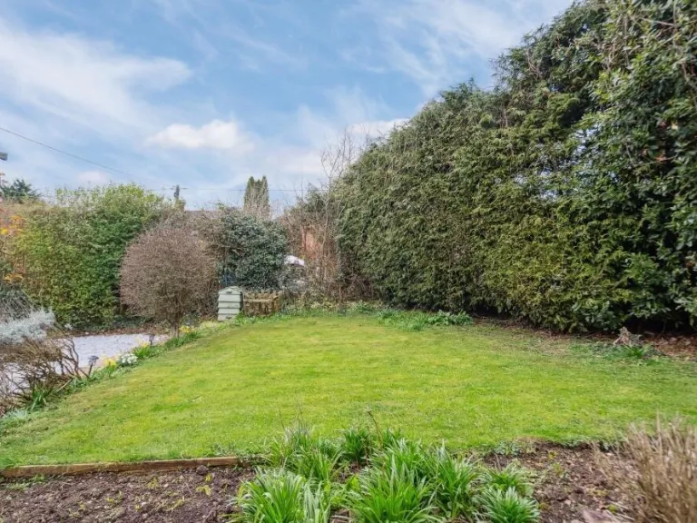
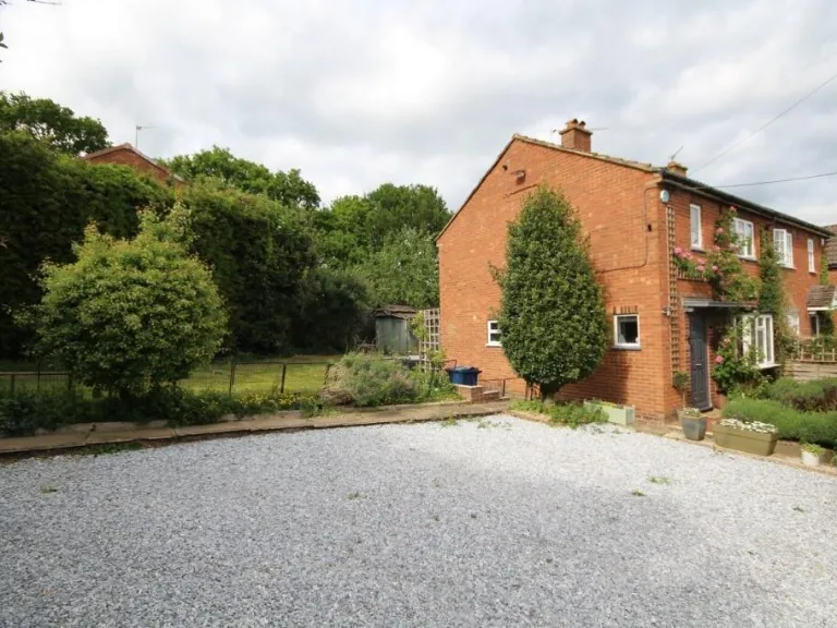
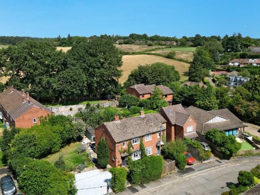
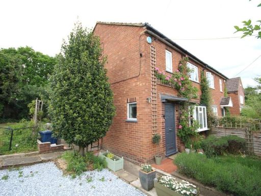
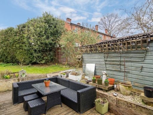
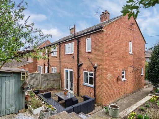
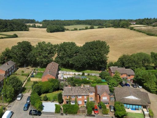
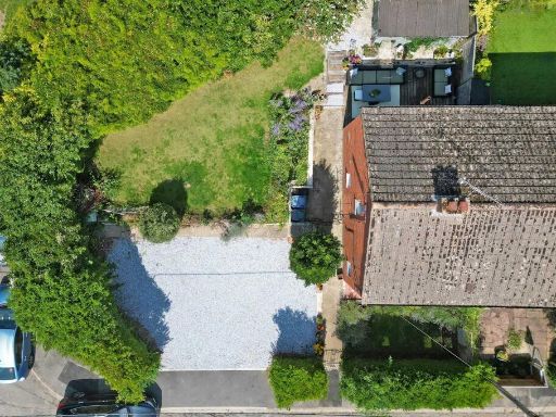
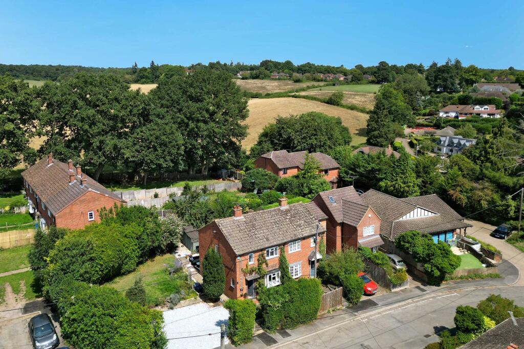
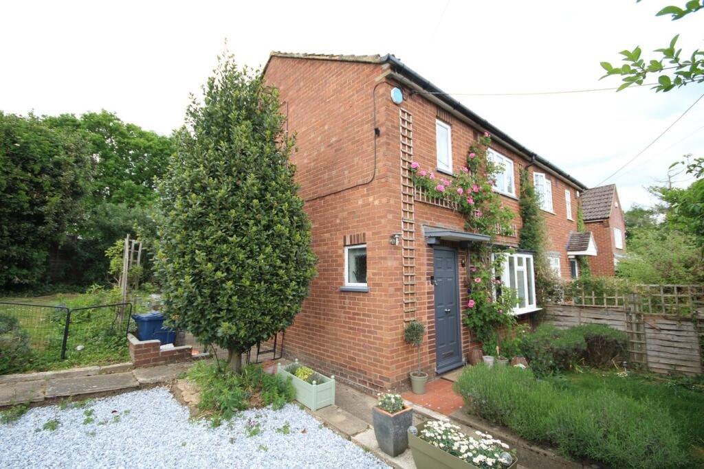
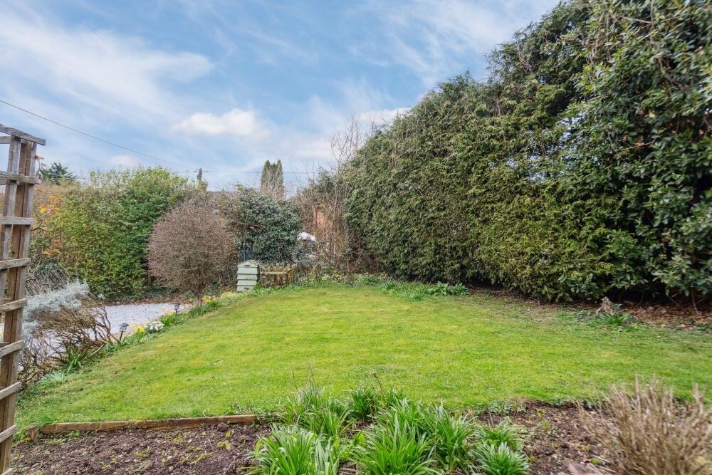
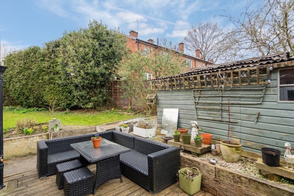
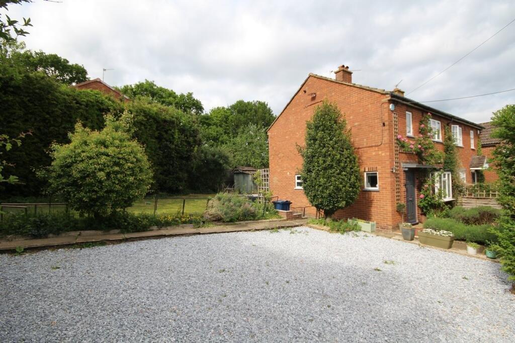
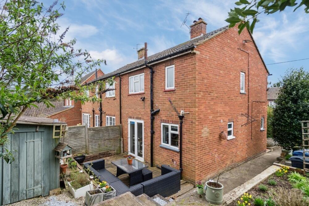
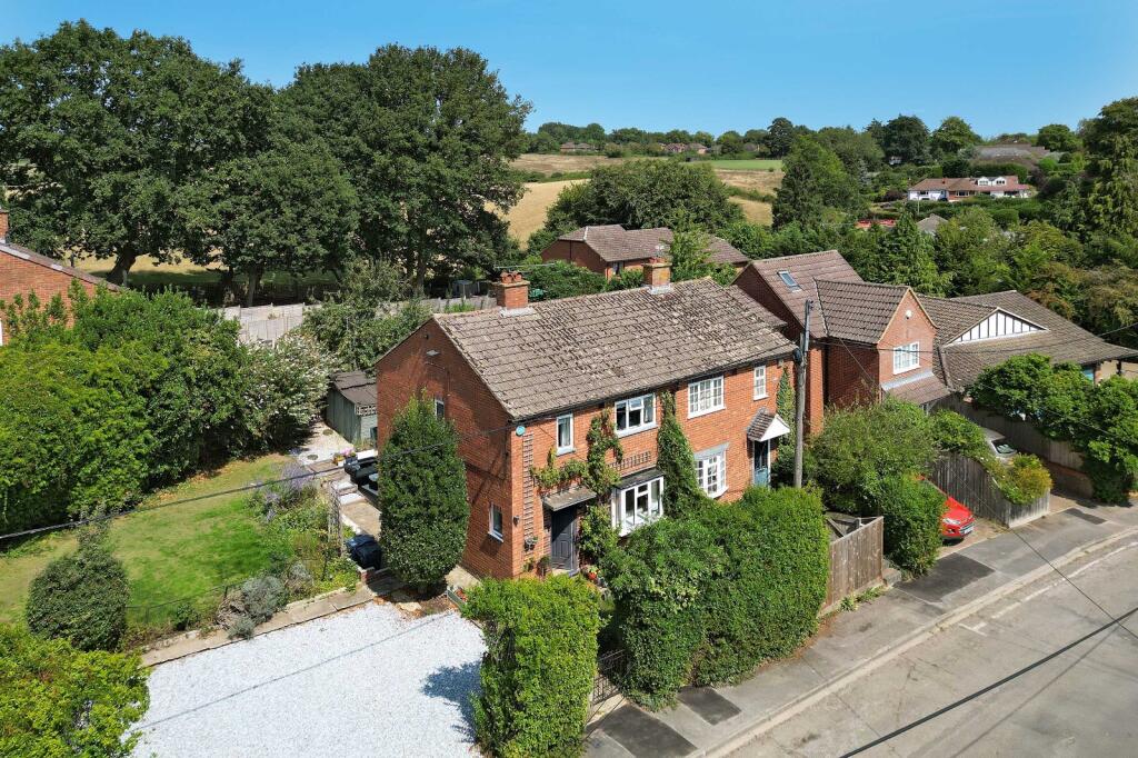
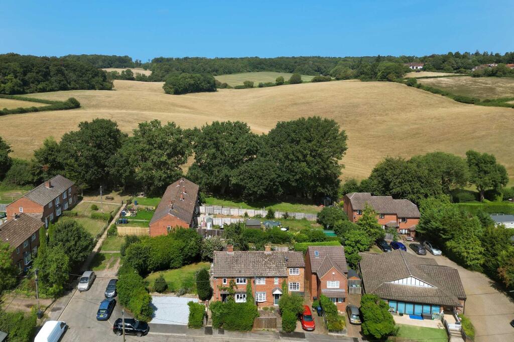
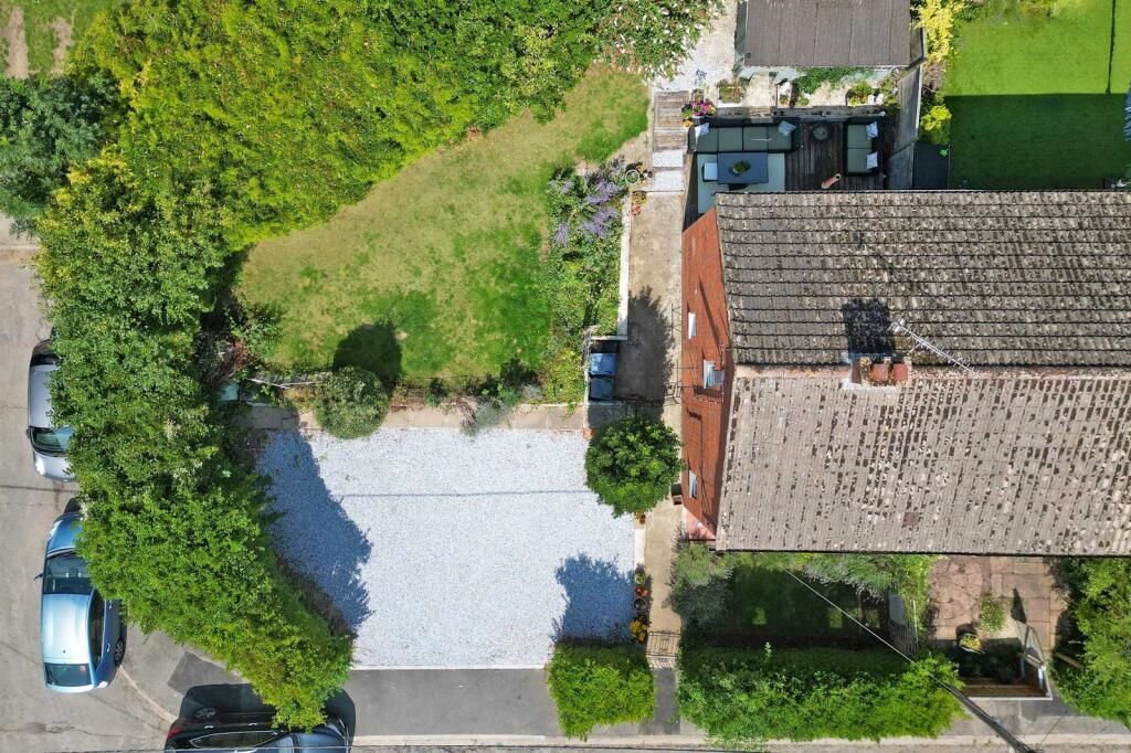
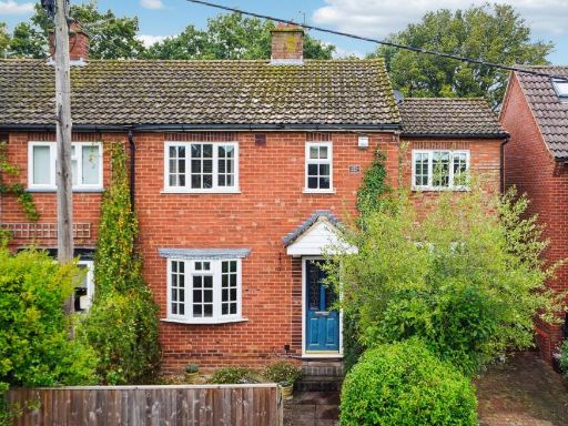
- The property is a substantial detached brick house situated on a quiet, leafy close in Forty Green, Beaconsfield, Buckinghamshire. It features a large, mature garden with well-established trees and shrubs, providing privacy and greenery. The house itself appears to be two stories, with multiple windows offering plenty of natural light. There is a driveway with off-street parking visible, likely suitable for several cars. The rear garden is large and well maintained, ideal for family use. The location provides scenic views of the surrounding countryside and nearby woods, contributing to a tranquil setting. The overall property size is large, with both the house and outdoor space offering generous accommodation.
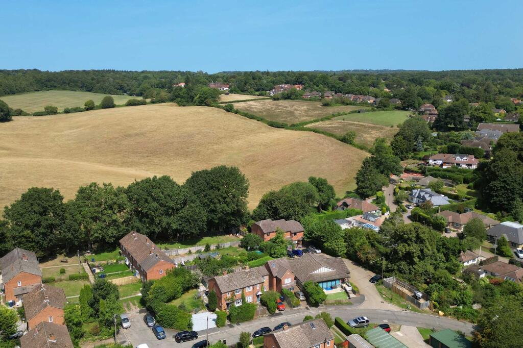
- The property for sale appears to be a detached or semi-detached house located in a suburban area with plenty of greenery and direct proximity to expansive fields and open countryside. The house benefits from a large private garden and is situated within a well-established neighbourhood, offering both privacy and scenic rural views. The plot size is generous with ample space surrounding the property, especially in the rear garden. The house appears to be medium to large in size, ideal for family living.
Image Descriptions
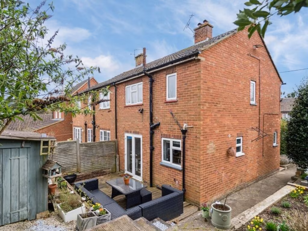
- semi-detached house traditional brick
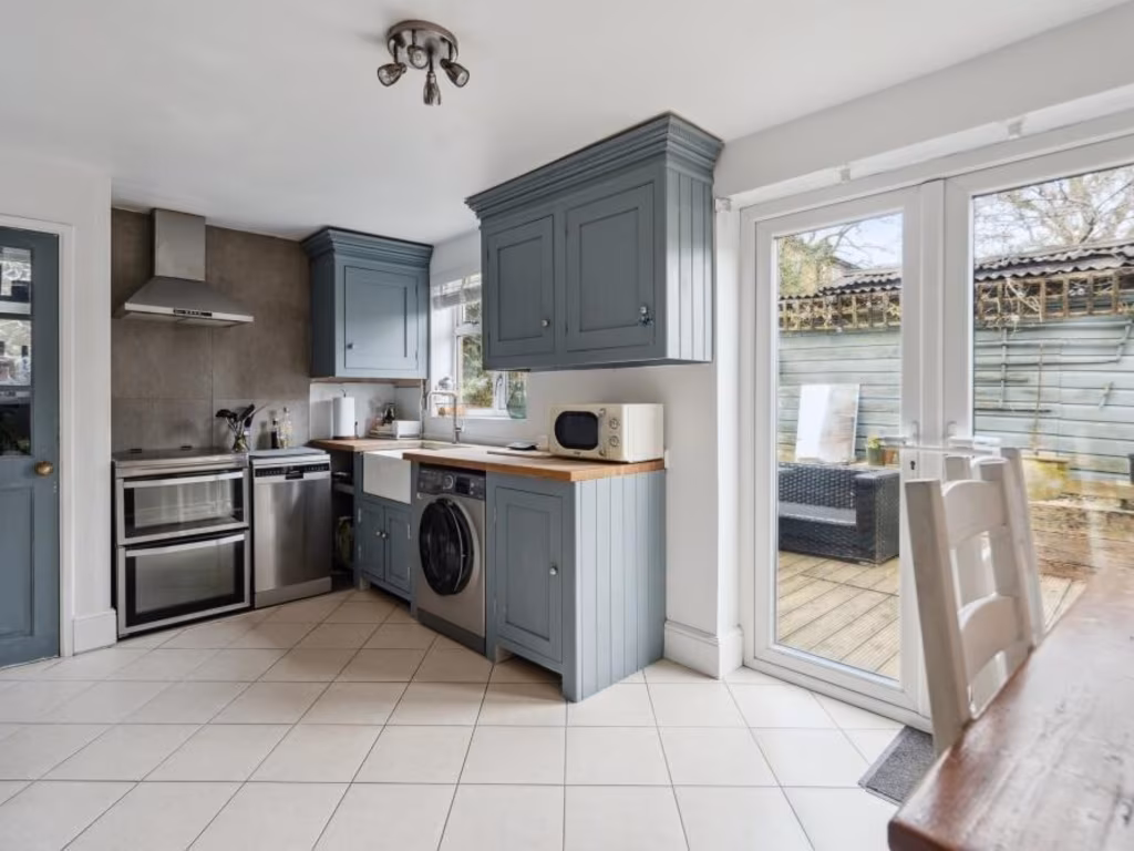
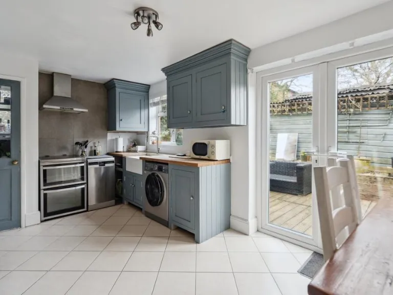
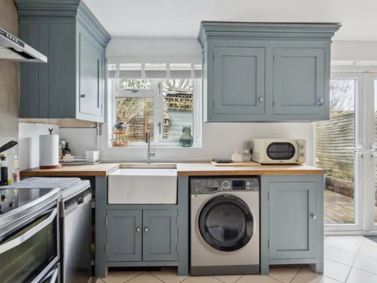
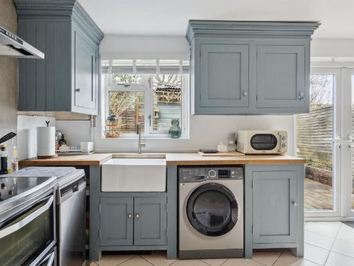
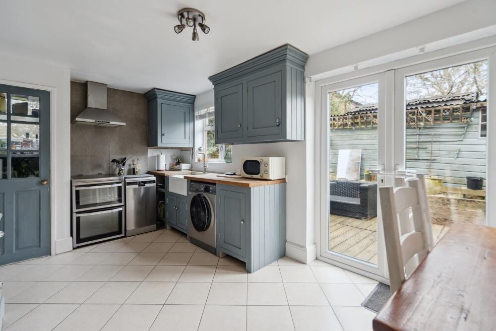
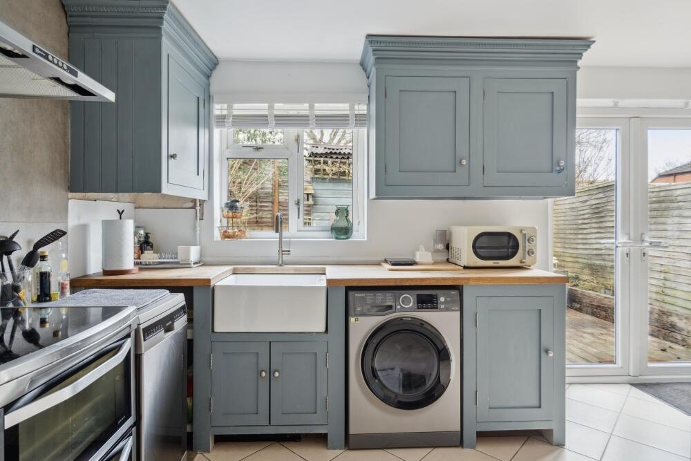
- kitchen Modern
Floorplan Description
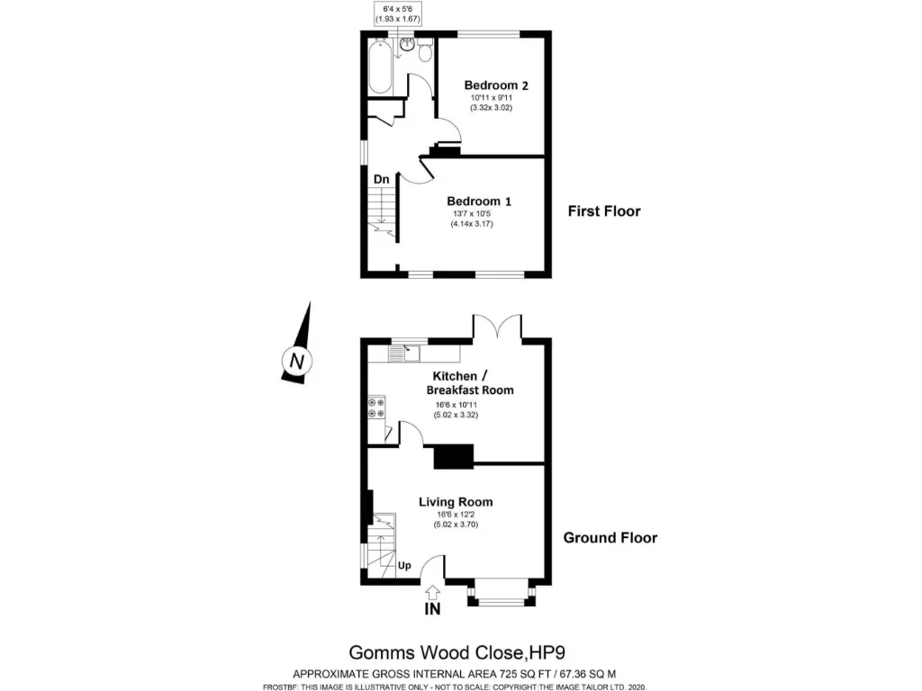
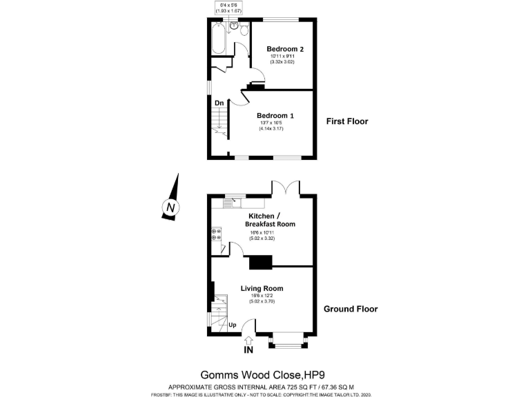
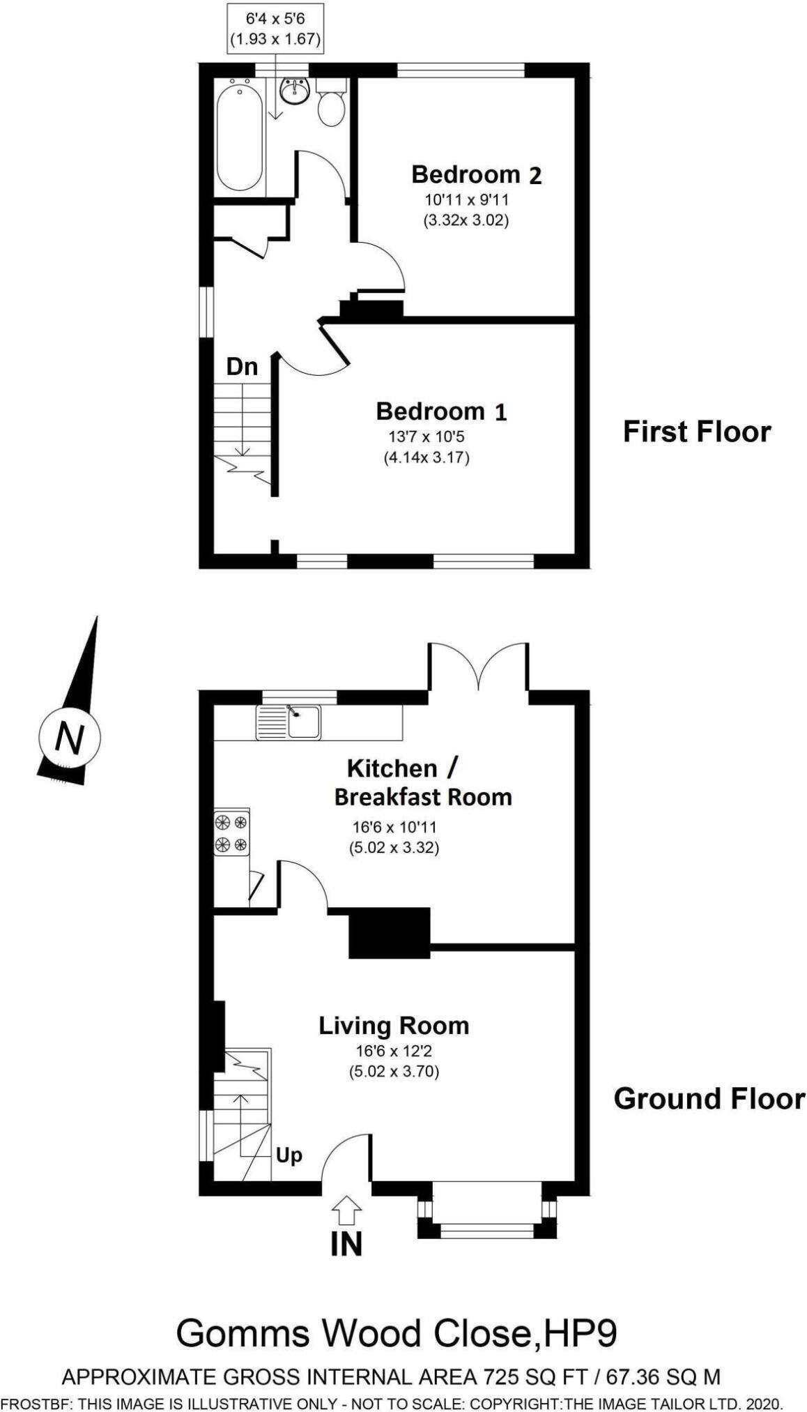
- A compact two-story property with two bedrooms and ample living space.
Rooms
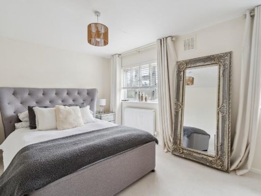
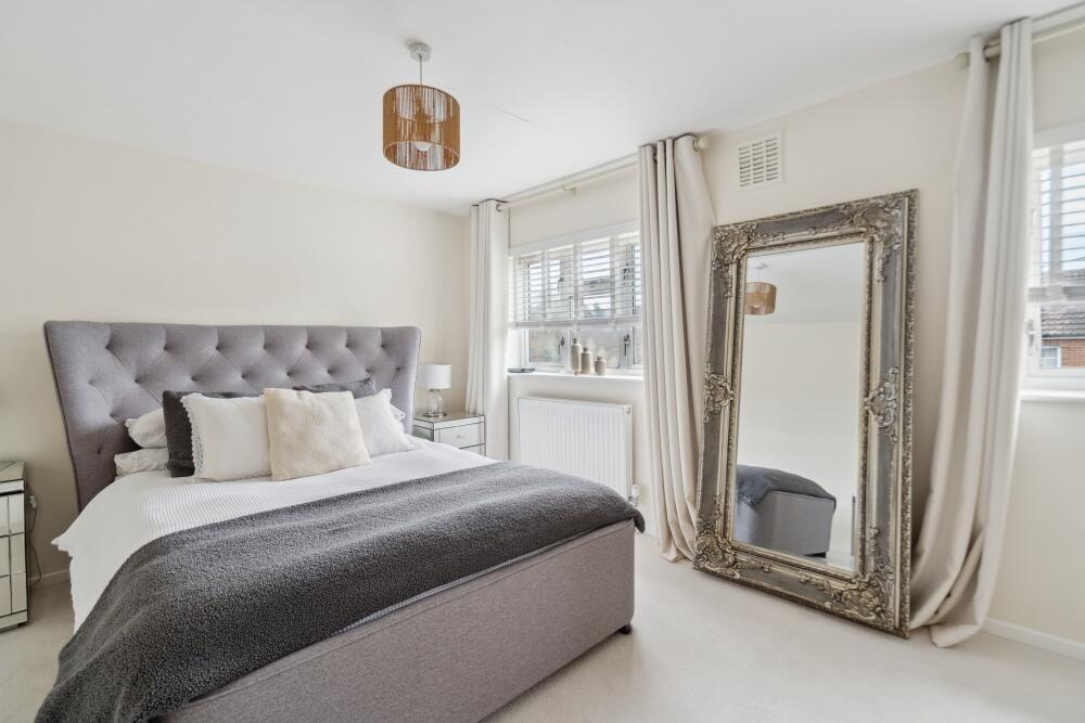
- Bedroom 1: average
- Bedroom 2: average
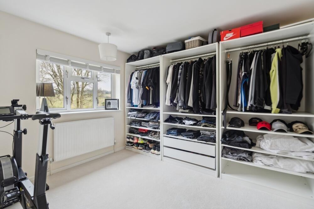
- Kitchen / Breakfast Room: large
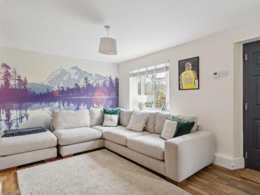
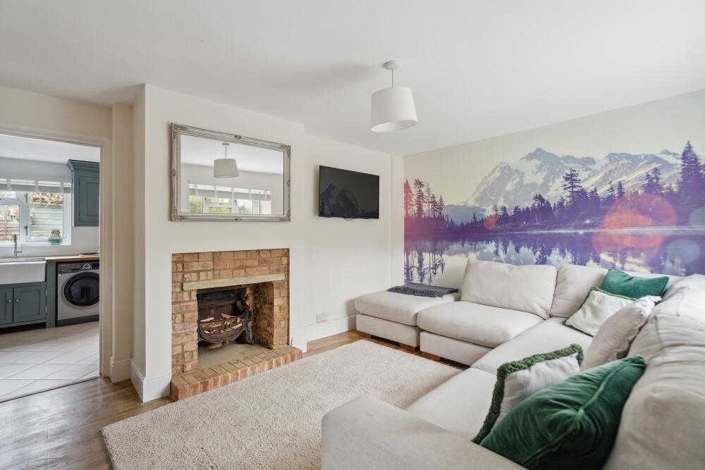
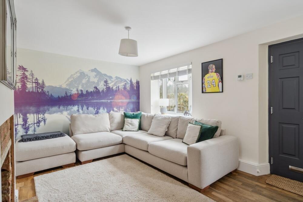
- Living Room: large
Textual Property Features
- Has Garden
- Chain Free
- Success
Detected Visual Features
- semi-detached
- traditional brick
- two-story
- gable roof
- brick chimneys
- greenery
- landscaped garden
- rural setting
- driveway
- kitchen
- modern style
- tile floor
- outdoor access
- grey cabinets
- metal appliances
- well-maintained
- natural light
EPC Details
- Fully double glazed
- Cavity wall, filled cavity
- Boiler and radiators, mains gas
- Low energy lighting in 56% of fixed outlets
- Solid, no insulation (assumed)
Nearby Schools
- St Paul's Church of England Combined School, Wooburn
- Ash Hill Primary School
- Tylers Green Middle School
- Holmer Green Senior School
- Bourne End Academy
- Juniper Hill School
- Carrington Infant School
- Butlers Court School
- St Mary and All Saints CofE Primary School
- Marsh School
- Curzon Church of England Combined School
- Dropmore Infant School
- Carrington Junior School
- Davenies School
- Loudwater Combined School
- High March School
- Tylers Green First School
- Coleshill Church of England Infant School
- Holmer Green Junior School
- Wooburn Green Primary School
- The Beaconsfield School
- Beaconsfield High School
- Holtspur School & Pre-School
- Seer Green Church of England School
- Manor Farm Community Infant School
- Manor Farm Junior School
- Hazlemere Church of England Combined School
Nearest Bars And Restaurants
- Id: 5711838372
- Tags:
- TagsNormalized:
- Lat: 51.6132425
- Lon: -0.6474115
- FullGeoHash: gcpt97bsfjyb
- PartitionGeoHash: gcpt
- Images:
- FoodStandards: null
- Distance: 1234.3
,- Id: 5711838368
- Tags:
- Amenity: restaurant
- Cuisine: chinese
- Name: Jasmine
- TagsNormalized:
- Lat: 51.6129452
- Lon: -0.6478836
- FullGeoHash: gcpt97b5pnqf
- PartitionGeoHash: gcpt
- Images:
- FoodStandards: null
- Distance: 1220.6
,- Id: 15949627
- Tags:
- Amenity: pub
- Name: The Red Lion
- TagsNormalized:
- Lat: 51.6225468
- Lon: -0.6547651
- FullGeoHash: gcpt9je5nu5y
- PartitionGeoHash: gcpt
- Images:
- FoodStandards: null
- Distance: 771.1
,- Id: 357464401
- Tags:
- Amenity: pub
- Name: Royal Standard of England
- TagsNormalized:
- Lat: 51.6187318
- Lon: -0.669004
- FullGeoHash: gcpt8ubugj43
- PartitionGeoHash: gcpt
- Images:
- FoodStandards: null
- Distance: 389.8
,- Id: 812968882
- Tags:
- Amenity: pub
- Building: yes
- Food: yes
- Name: The Royal Standard of England
- Outdoor_seating: yes
- TagsNormalized:
- Lat: 51.6186528
- Lon: -0.6685899
- FullGeoHash: gcpt8uchkwr1
- PartitionGeoHash: gcpt
- Images:
- FoodStandards: null
- Distance: 360.2
}
Nearest General Shops
- Id: 5711838358
- Tags:
- Name: Jon James
- Shop: clothes
- TagsNormalized:
- Lat: 51.613474
- Lon: -0.6475295
- FullGeoHash: gcpt97bqr2zj
- PartitionGeoHash: gcpt
- Images:
- FoodStandards: null
- Distance: 1215.8
,- Id: 5711838365
- Tags:
- Name: The House of Klamer
- Shop: hairdresser
- Website: https://houseofklamer.co.uk/
- TagsNormalized:
- Lat: 51.6131051
- Lon: -0.6479761
- FullGeoHash: gcpt97bhjh4h
- PartitionGeoHash: gcpt
- Images:
- FoodStandards: null
- Distance: 1206.6
,- Id: 5711838364
- Tags:
- Name: Euronics Fields
- Shop: electronics
- Website: https://www.fields.org.uk/
- TagsNormalized:
- Lat: 51.6131825
- Lon: -0.6480217
- FullGeoHash: gcpt97bhefxf
- PartitionGeoHash: gcpt
- Images:
- FoodStandards: null
- Distance: 1199.8
}
Nearest Religious buildings
- Id: 858127498
- Tags:
- Addr:
- City: High Wycombe
- Place: Penn
- Postcode: HP10 8NY
- Street: Church Road
- Amenity: place_of_worship
- Building: church
- Denomination: anglican
- Fhrs:
- Name: Holy Trinity
- Religion: christian
- Source:
- Wikidata: Q40104932
- TagsNormalized:
- place of worship
- church
- anglican
- christian
- Lat: 51.6308868
- Lon: -0.6775326
- FullGeoHash: gcpt8x4esqgh
- PartitionGeoHash: gcpt
- Images:
- FoodStandards:
- Id: 712478
- FHRSID: 712478
- LocalAuthorityBusinessID: 14/00047/FNURSL
- BusinessName: Little Oaks One
- BusinessType: Hospitals/Childcare/Caring Premises
- BusinessTypeID: 5
- AddressLine1: Holy Trinity Church Hall
- AddressLine2: Church Road
- AddressLine3: Penn
- AddressLine4: Buckinghamshire
- PostCode: HP10 8NY
- RatingValue: 5
- RatingKey: fhrs_5_en-GB
- RatingDate: 2018-11-08
- LocalAuthorityCode: 021
- LocalAuthorityName: Buckinghamshire
- LocalAuthorityWebSite: http://www.buckinghamshire.gov.uk
- LocalAuthorityEmailAddress: environmentalhealth@buckinghamshire.gov.uk
- Scores:
- Hygiene: 0
- Structural: 5
- ConfidenceInManagement: 0
- NewRatingPending: false
- Geocode:
- Longitude: -0.67712600000000
- Latitude: 51.63160500000000
- Distance: 1716.6
,- Id: 242595095
- Tags:
- Amenity: place_of_worship
- Building: church
- Denomination: anglican
- Name: St Michael & All Angels
- Religion: christian
- Website: https://stmichaelsbeaconsfield.org.uk/
- Wikidata: Q26538649
- TagsNormalized:
- place of worship
- church
- anglican
- christian
- Lat: 51.6135398
- Lon: -0.6426323
- FullGeoHash: gcpt97un9t4t
- PartitionGeoHash: gcpt
- Images:
- FoodStandards: null
- Distance: 1525.5
,- Id: 495249018
- Tags:
- Amenity: place_of_worship
- Building: yes
- Denomination: catholic
- Name: St Teresa
- Religion: christian
- TagsNormalized:
- place of worship
- catholic
- christian
- church
- Lat: 51.6127656
- Lon: -0.644716
- FullGeoHash: gcpt97fd1hbg
- PartitionGeoHash: gcpt
- Images:
- FoodStandards: null
- Distance: 1425.1
}
Nearest Medical buildings
- Id: 5711838183
- Tags:
- Amenity: doctors
- Name: Doctor Now
- Website: https://doctornow.org/
- TagsNormalized:
- Lat: 51.6010064
- Lon: -0.6350532
- FullGeoHash: gcpt999tdhy0
- PartitionGeoHash: gcpt
- Images:
- FoodStandards: null
- Distance: 2735.5
,- Id: 5711840837
- Tags:
- Amenity: veterinary
- Name: Straid Veterinary Clinic
- Website: https://www.straidvetclinic.co.uk/
- TagsNormalized:
- Lat: 51.6057576
- Lon: -0.6381458
- FullGeoHash: gcpt96x364kn
- PartitionGeoHash: gcpt
- Images:
- FoodStandards: null
- Distance: 2225.6
,- Id: 5711837986
- Tags:
- Amenity: pharmacy
- Name: Pyramid Pharmacy
- Website: https://www.nhs.uk/Services/pharmacies/Overview/DefaultView.aspx?id=130293
- TagsNormalized:
- Lat: 51.610565
- Lon: -0.6454508
- FullGeoHash: gcpt973vrfth
- PartitionGeoHash: gcpt
- Images:
- FoodStandards: null
- Distance: 1502.1
,- Id: 474413971
- Tags:
- Addr:
- Housenumber: 7-9
- Postcode: HP9 1NL
- Street: Station Road
- Amenity: pharmacy
- Brand:
- Fhrs:
- Name: Boots
- Operator: Boots
- Website: https://www.boots.com/stores/1092-beaconsfield-station-road-hp9-1nl
- TagsNormalized:
- Lat: 51.6110223
- Lon: -0.6458423
- FullGeoHash: gcpt973xyzch
- PartitionGeoHash: gcpt
- Images:
- FoodStandards:
- Id: 777286
- FHRSID: 777286
- LocalAuthorityBusinessID: 14380/0079/0/000_SB
- BusinessName: Boots UK Ltd
- BusinessType: Retailers - other
- BusinessTypeID: 4613
- AddressLine1: Boots
- AddressLine2: 7 - 9 Station Road
- AddressLine3: Beaconsfield
- AddressLine4: Buckinghamshire
- PostCode: HP9 1NL
- RatingValue: 5
- RatingKey: fhrs_5_en-GB
- RatingDate: 2012-02-23
- LocalAuthorityCode: 021
- LocalAuthorityName: Buckinghamshire
- LocalAuthorityWebSite: http://www.buckinghamshire.gov.uk
- LocalAuthorityEmailAddress: environmentalhealth@buckinghamshire.gov.uk
- Scores:
- Hygiene: 5
- Structural: 5
- ConfidenceInManagement: 0
- NewRatingPending: false
- Geocode:
- Longitude: -0.64556200000000
- Latitude: 51.61099600000000
- Distance: 1451.4
}
Nearest Airports
- Id: 14001268
- Tags:
- Access: yes
- Aerodrome: international
- Aerodrome:type: public
- Aeroway: aerodrome
- Alt_name: London Heathrow
- Alt_name_2: London Heathrow Airport
- Ele: 25
- Iata: LHR
- Icao: EGLL
- Int_name: Heathrow Airport
- Name: London Heathrow Airport
- Note: area still approx
- Old_name: London Airport
- Operator: Heathrow Airport Limited
- Rank_aci:
- Ref: LHR
- Short_name: Heathrow
- Type: multipolygon
- Website: https://www.heathrow.com/
- Wikidata: Q8691
- Wikipedia: en:Heathrow Airport
- TagsNormalized:
- airport
- international airport
- Lat: 51.4677522
- Lon: -0.4547736
- FullGeoHash: gcpsv9kv7h2h
- PartitionGeoHash: gcps
- Images:
- FoodStandards: null
- Distance: 22090
}
Nearest Leisure Facilities
- Id: 1005430706
- Tags:
- TagsNormalized:
- Lat: 51.614162
- Lon: -0.6453069
- FullGeoHash: gcpt9k44730m
- PartitionGeoHash: gcpt
- Images:
- FoodStandards: null
- Distance: 1328.3
,- Id: 495208165
- Tags:
- Leisure: pitch
- Name: Knotty Green Cricket Ground
- Sport: cricket
- Surface: grass
- Website: https://www.knottygreencricketclub.uk/
- TagsNormalized:
- pitch
- leisure
- cricket
- sports
- Lat: 51.6213023
- Lon: -0.6545069
- FullGeoHash: gcpt9j77uuhq
- PartitionGeoHash: gcpt
- Images:
- FoodStandards: null
- Distance: 707.6
,- Id: 600870588
- Tags:
- TagsNormalized:
- Lat: 51.6209176
- Lon: -0.6556309
- FullGeoHash: gcpt9j69dsqp
- PartitionGeoHash: gcpt
- Images:
- FoodStandards: null
- Distance: 619
,- Id: 495207834
- Tags:
- Leisure: park
- Name: Knotty Green Park
- TagsNormalized:
- Lat: 51.6206408
- Lon: -0.655734
- FullGeoHash: gcpt9j6802ck
- PartitionGeoHash: gcpt
- Images:
- FoodStandards: null
- Distance: 598.1
,- Id: 860362453
- Tags:
- Leisure: pitch
- Sport: equestrian
- TagsNormalized:
- pitch
- leisure
- equestrian
- sports
- Lat: 51.6159033
- Lon: -0.6671155
- FullGeoHash: gcpt8u6hrjf8
- PartitionGeoHash: gcpt
- Images:
- FoodStandards: null
- Distance: 358.3
}
Nearest Tourist attractions
- Id: 6090716442
- Tags:
- Name: Odds Farm Theme Park
- Tourism: theme_park
- TagsNormalized:
- Lat: 51.5800965
- Lon: -0.6657042
- FullGeoHash: gcpt2vg5zfyu
- PartitionGeoHash: gcpt
- Images:
- FoodStandards: null
- Distance: 4236.7
,- Id: 40110523
- Tags:
- Addr:
- City: Beaconsfield
- Postcode: HP9 2PL
- Street: Warwick Road
- Dogs: no
- Name: Bekonscot Model Village
- Tourism: theme_park
- Website: https://www.bekonscot.co.uk/
- Wikidata: Q2894118
- Wikipedia: en:Bekonscot
- TagsNormalized:
- Lat: 51.6137761
- Lon: -0.6448325
- FullGeoHash: gcpt9k42n34p
- PartitionGeoHash: gcpt
- Images:
- FoodStandards: null
- Distance: 1373.9
,- Id: 169907726
- Tags:
- TagsNormalized:
- Lat: 51.6142327
- Lon: -0.6446352
- FullGeoHash: gcpt9k4ddym4
- PartitionGeoHash: gcpt
- Images:
- FoodStandards: null
- Distance: 1369.6
}
Nearest Bus stations and stops
- Id: 2966094348
- Tags:
- Bus: yes
- Highway: bus_stop
- Public_transport: platform
- TagsNormalized:
- Lat: 51.6144236
- Lon: -0.701573
- FullGeoHash: gcpt8h15u1vm
- PartitionGeoHash: gcpt
- Images:
- FoodStandards: null
- Distance: 2666.3
,- Id: 1966940989
- Tags:
- Bench: yes
- Bus: yes
- Highway: bus_stop
- Name: Loudwater Turn
- Public_transport: platform
- Shelter: yes
- TagsNormalized:
- Lat: 51.6100164
- Lon: -0.6996609
- FullGeoHash: gcpt856d0sr5
- PartitionGeoHash: gcpt
- Images:
- FoodStandards: null
- Distance: 2660.9
,- Id: 2891415685
- Tags:
- Bus: yes
- Highway: bus_stop
- Name: The Papermill
- Public_transport: platform
- TagsNormalized:
- Lat: 51.607481
- Lon: -0.6960541
- FullGeoHash: gcpt84v5kg8r
- PartitionGeoHash: gcpt
- Images:
- FoodStandards: null
- Distance: 2547.1
,- Id: 2891415688
- Tags:
- Bench: yes
- Bus: yes
- Highway: bus_stop
- Name: The Papermill
- Public_transport: platform
- Shelter: yes
- TagsNormalized:
- Lat: 51.6075921
- Lon: -0.696008
- FullGeoHash: gcpt84vhjb6y
- PartitionGeoHash: gcpt
- Images:
- FoodStandards: null
- Distance: 2538.5
,- Id: 3021381786
- Tags:
- Bus: yes
- Highway: bus_stop
- Name: Whitehouse Lane
- Public_transport: platform
- TagsNormalized:
- Lat: 51.6023047
- Lon: -0.6862875
- FullGeoHash: gcpt83um0qfc
- PartitionGeoHash: gcpt
- Images:
- FoodStandards: null
- Distance: 2367.3
}
Nearest Hotels
- Id: 604413890
- Tags:
- Addr:
- City: Beaconsfield
- Postcode: HP9 2SE
- Street: ExtraMSA Beaconsfield Services
- Brand: Ibis Budget
- Brand:wikidata: Q1458135
- Brand:wikipedia: en:Ibis Budget
- Building: yes
- Email: h6598@accor.com
- Internet_access: wlan
- Name: Ibis Budget Beaconsfield
- Phone: +44 1494680929
- Rooms: 105
- Tourism: hotel
- Website: https://all.accor.com/hotel/6598/index.en.shtml
- TagsNormalized:
- Lat: 51.5877403
- Lon: -0.627016
- FullGeoHash: gcpt3xr2m7yc
- PartitionGeoHash: gcpt
- Images:
- FoodStandards: null
- Distance: 4216
,- Id: 5711840681
- Tags:
- Addr:
- Postcode: HP9 1LW
- Street: Aylesbury End
- Brand: Travelodge
- Brand:wikidata: Q9361374
- Brand:wikipedia: en:Travelodge UK
- Fhrs:
- Authority: Buckinghamshire
- Id: 777087
- Local_authority_id: 10/00058/HOTEL_SB
- Internet_access: wlan
- Internet_access:fee: customers
- Internet_access:ssid: Travelodge WiFi
- Name: Travelodge Beaconsfield Central
- Tourism: hotel
- Website: https://www.travelodge.co.uk/hotels/442/Beaconsfield-Central-hotel
- TagsNormalized:
- Lat: 51.6023842
- Lon: -0.6369603
- FullGeoHash: gcpt99bjttxg
- PartitionGeoHash: gcpt
- Images:
- FoodStandards: null
- Distance: 2534.3
,- Id: 109161179
- Tags:
- Brand: Premier Inn
- Brand:wikidata: Q2108626
- Building: yes
- Name: Premier Inn High Wycombe
- Operator: Premier Inn
- Tourism: hotel
- TagsNormalized:
- Lat: 51.6076748
- Lon: -0.6940133
- FullGeoHash: gcpt84yskrf5
- PartitionGeoHash: gcpt
- Images:
- FoodStandards: null
- Distance: 2412.8
}
Tags
- semi-detached
- traditional brick
- two-story
- gable roof
- brick chimneys
- greenery
- landscaped garden
- rural setting
- driveway
- kitchen
- modern style
- tile floor
- outdoor access
- grey cabinets
- metal appliances
- well-maintained
- natural light
Local Market Stats
- Average Price/sqft: £614
- Avg Income: £68200
- Rental Yield: 3.2%
- Social Housing: 6%
- Planning Success Rate: 89%
AirBnB Data
- 1km average: £164/night
- Listings in 1km: 6
Similar Properties
 3 bedroom semi-detached house for sale in Gomms Wood Close, Forty Green, HP9 — £635,000 • 3 bed • 1 bath • 958 ft²
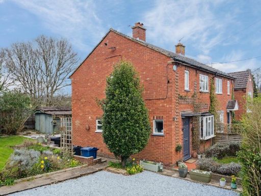 2 bedroom semi-detached house for sale in Gomms Wood Close, Forty Green, Beaconsfield, HP9 — £535,000 • 2 bed • 1 bath • 725 ft²
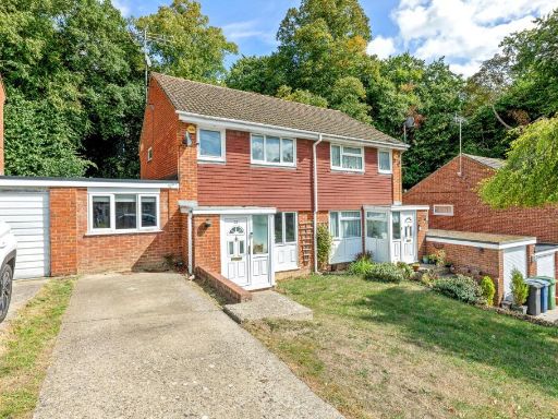 3 bedroom semi-detached house for sale in Clearbrook Close, Loudwater, HP13 — £485,000 • 3 bed • 1 bath • 1193 ft²
 3 bedroom semi-detached house for sale in Speen Road, North Dean, HP14 — £720,000 • 3 bed • 2 bath • 1345 ft²
 5 bedroom detached house for sale in Burnham Avenue, Beaconsfield, Buckinghamshire, HP9 — £1,850,000 • 5 bed • 5 bath • 3110 ft²
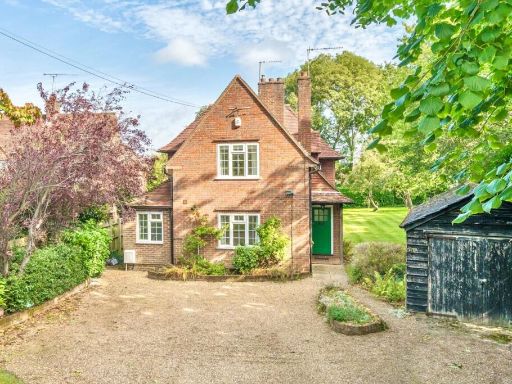 3 bedroom detached house for sale in Candlemas Lane, Beaconsfield, HP9 — £1,000,000 • 3 bed • 1 bath • 1400 ft²
Meta
- {
"@context": "https://schema.org",
"@type": "Residence",
"name": "2 bedroom semidetached house for sale in Gomms Wood Close,…",
"description": "",
"url": "https://propertypiper.co.uk/property/c102fc3a-6913-4db4-a95a-c99e2700622a",
"image": "https://image-a.propertypiper.co.uk/2aaecf00-4212-4d94-b108-60e3f14d3146-1024.jpeg",
"address": {
"@type": "PostalAddress",
"streetAddress": "2 GOMMS WOOD CLOSE FORTY GREEN BEACONSFIELD",
"postalCode": "HP9 1XR",
"addressLocality": "Buckinghamshire",
"addressRegion": "Chesham and Amersham",
"addressCountry": "England"
},
"geo": {
"@type": "GeoCoordinates",
"latitude": 51.6181715,
"longitude": -0.6634299
},
"numberOfRooms": 2,
"numberOfBathroomsTotal": 1,
"floorSize": {
"@type": "QuantitativeValue",
"value": 725,
"unitCode": "FTK"
},
"offers": {
"@type": "Offer",
"price": 535000,
"priceCurrency": "GBP",
"availability": "https://schema.org/InStock"
},
"additionalProperty": [
{
"@type": "PropertyValue",
"name": "Feature",
"value": "semi-detached"
},
{
"@type": "PropertyValue",
"name": "Feature",
"value": "traditional brick"
},
{
"@type": "PropertyValue",
"name": "Feature",
"value": "two-story"
},
{
"@type": "PropertyValue",
"name": "Feature",
"value": "gable roof"
},
{
"@type": "PropertyValue",
"name": "Feature",
"value": "brick chimneys"
},
{
"@type": "PropertyValue",
"name": "Feature",
"value": "greenery"
},
{
"@type": "PropertyValue",
"name": "Feature",
"value": "landscaped garden"
},
{
"@type": "PropertyValue",
"name": "Feature",
"value": "rural setting"
},
{
"@type": "PropertyValue",
"name": "Feature",
"value": "driveway"
},
{
"@type": "PropertyValue",
"name": "Feature",
"value": "kitchen"
},
{
"@type": "PropertyValue",
"name": "Feature",
"value": "modern style"
},
{
"@type": "PropertyValue",
"name": "Feature",
"value": "tile floor"
},
{
"@type": "PropertyValue",
"name": "Feature",
"value": "outdoor access"
},
{
"@type": "PropertyValue",
"name": "Feature",
"value": "grey cabinets"
},
{
"@type": "PropertyValue",
"name": "Feature",
"value": "metal appliances"
},
{
"@type": "PropertyValue",
"name": "Feature",
"value": "well-maintained"
},
{
"@type": "PropertyValue",
"name": "Feature",
"value": "natural light"
}
]
}
High Res Floorplan Images
Compatible Floorplan Images
FloorplanImages Thumbnail