WV3 9LA - 5 bedroom detached house for sale in Ross Close, Wolverhamp…
View on Property Piper
5 bedroom detached house for sale in Ross Close, Wolverhampton, WV3
Property Details
- Price: £475000
- Bedrooms: 5
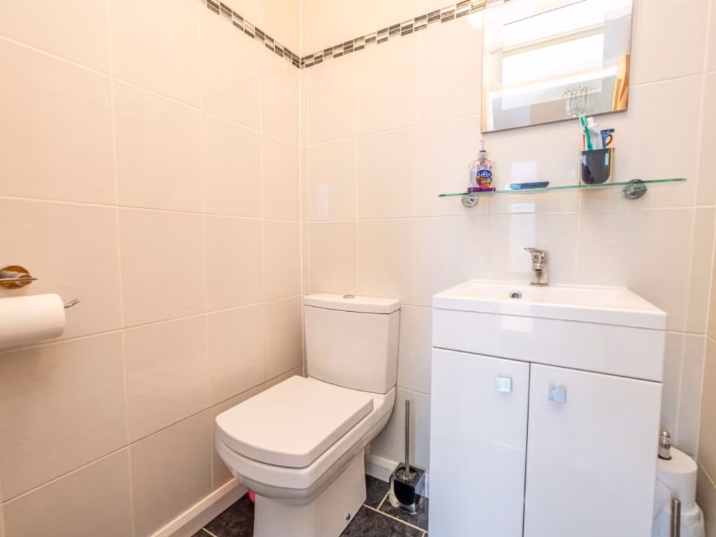
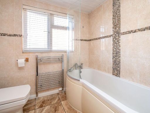
- Bathrooms: 2
- Property Type: undefined
- Property SubType: undefined
Image Descriptions
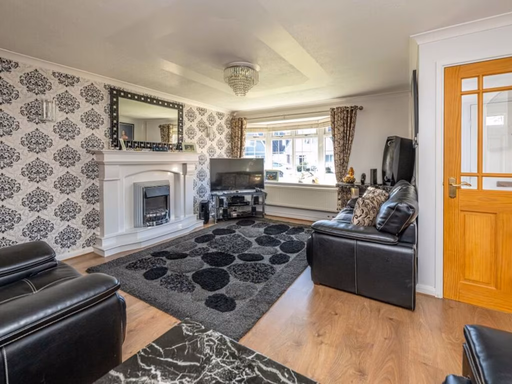
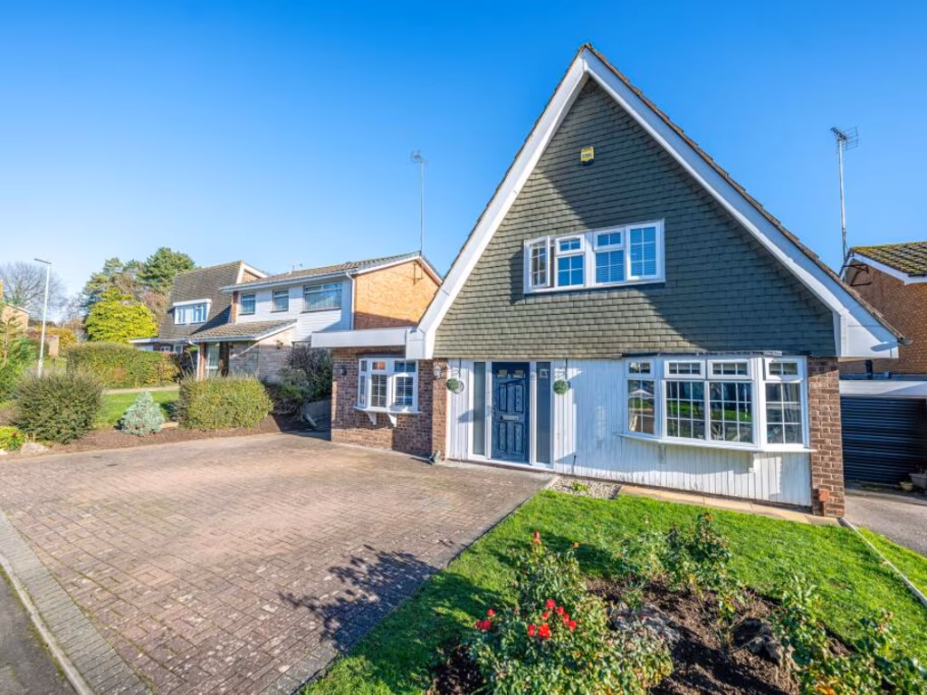
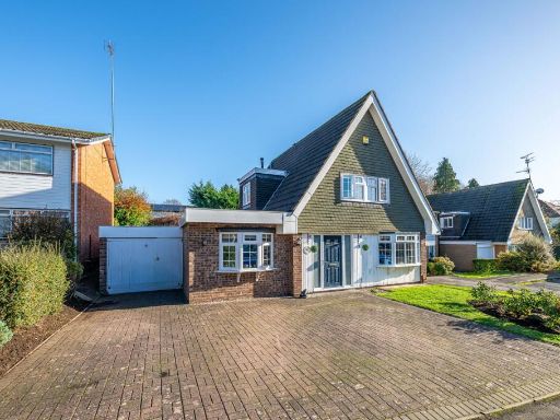
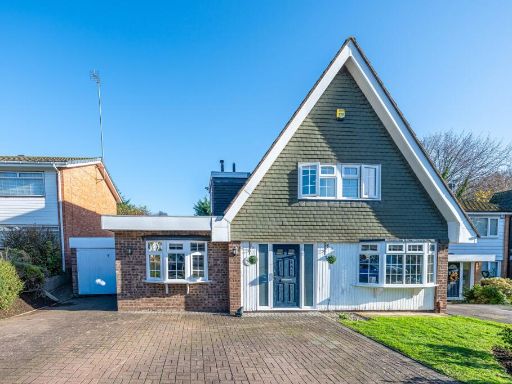
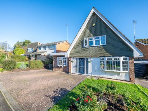
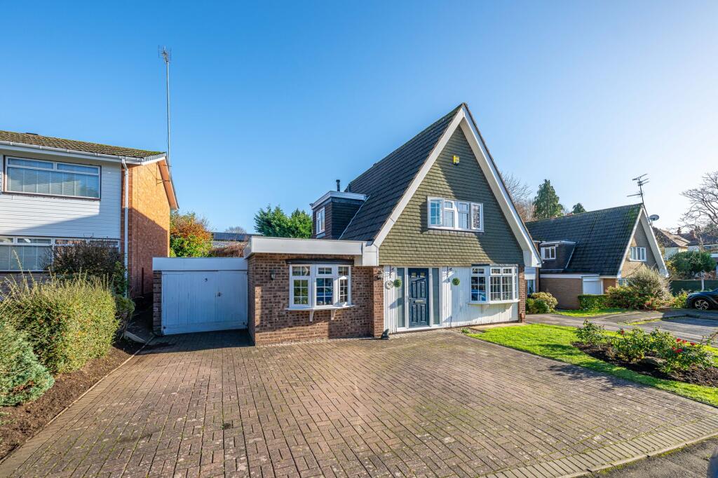
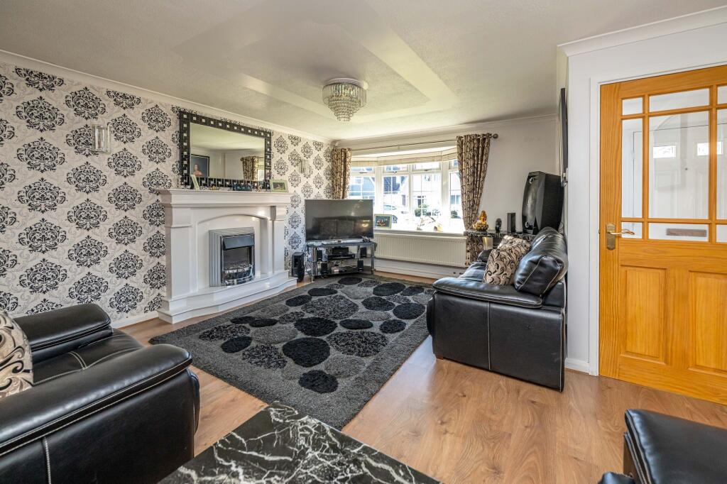
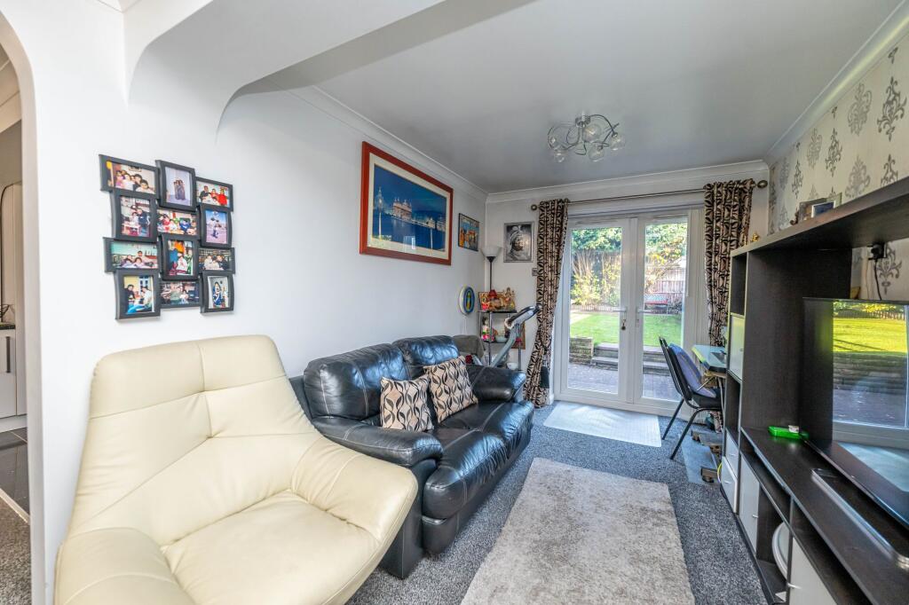
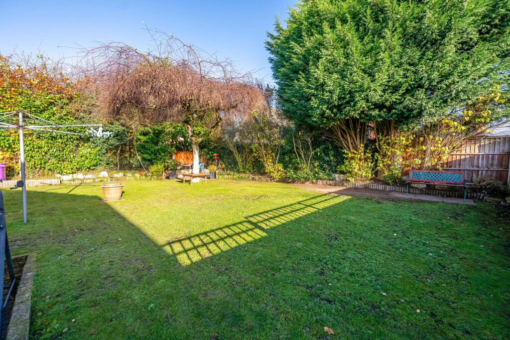
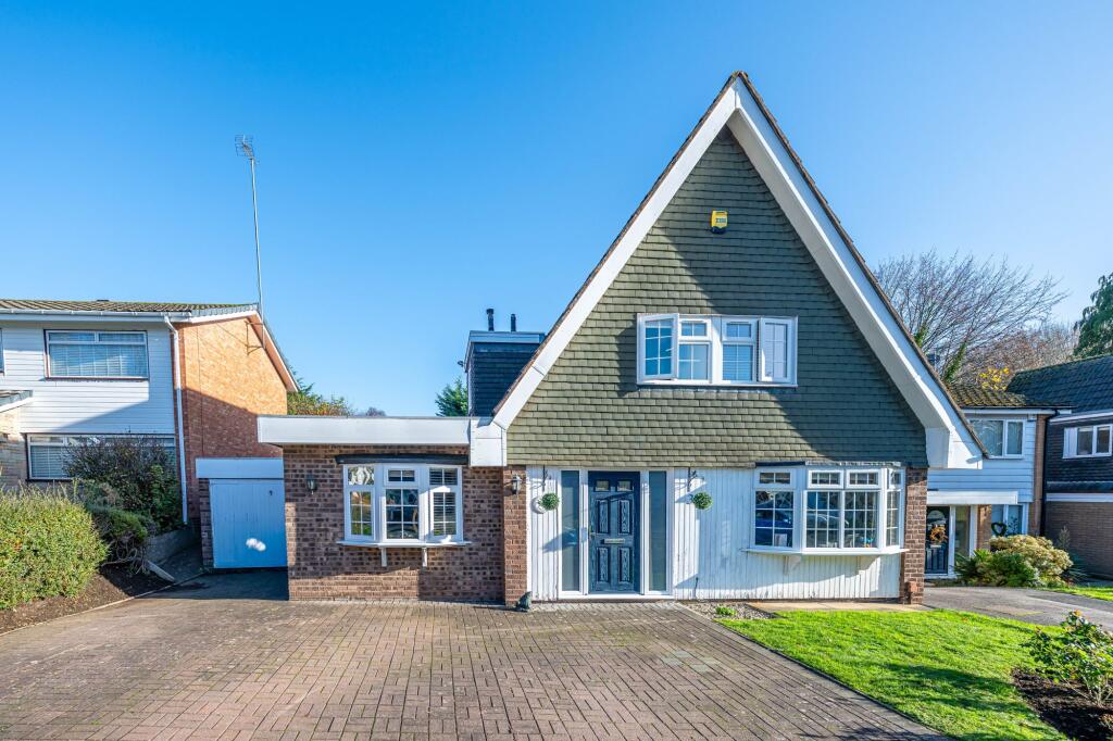
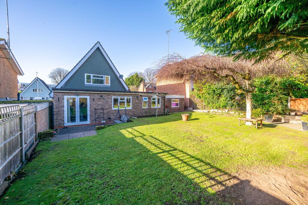
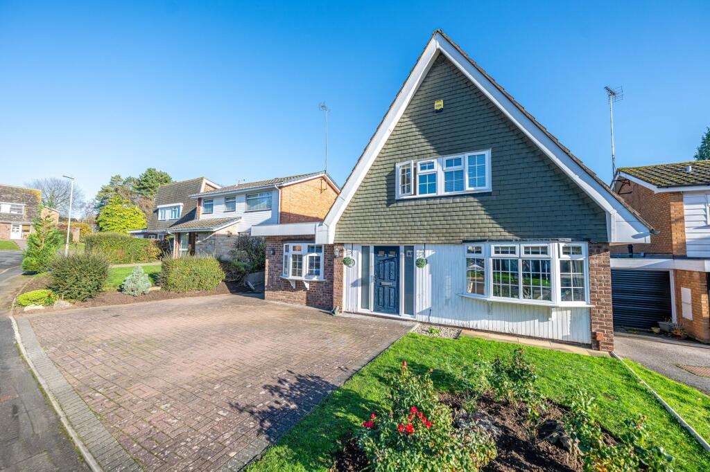
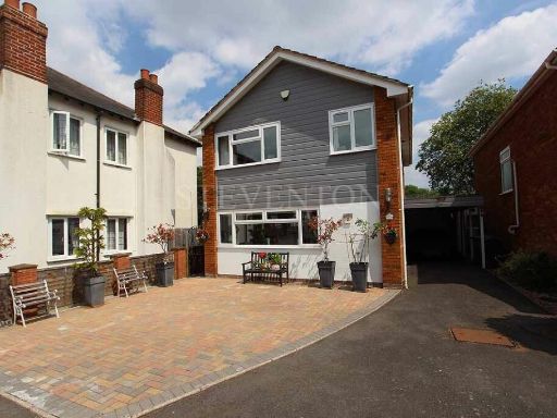
- detached house 1960s chalet-style
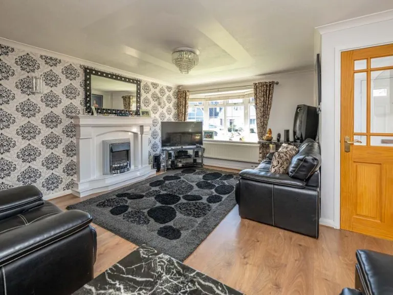
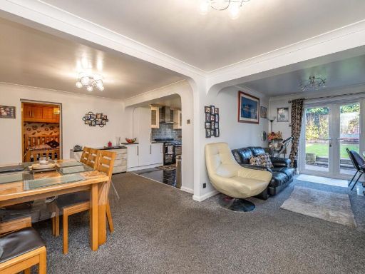
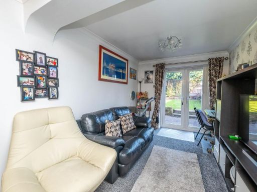
- living room modern
Floorplan Description
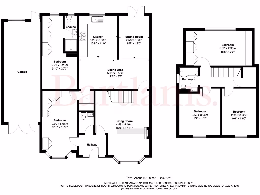
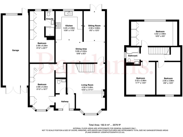
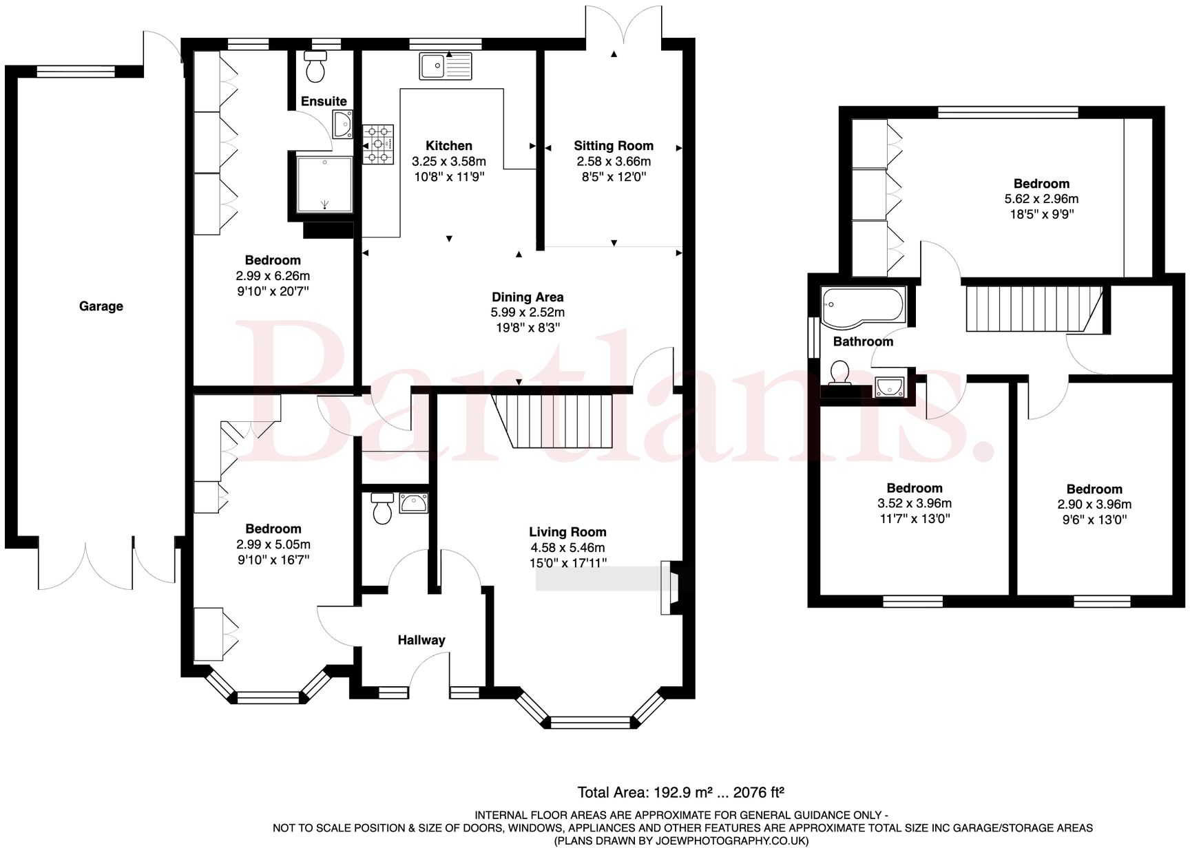
- Floorplan with multiple bedrooms, living, dining, kitchen and garage (garage excluded)
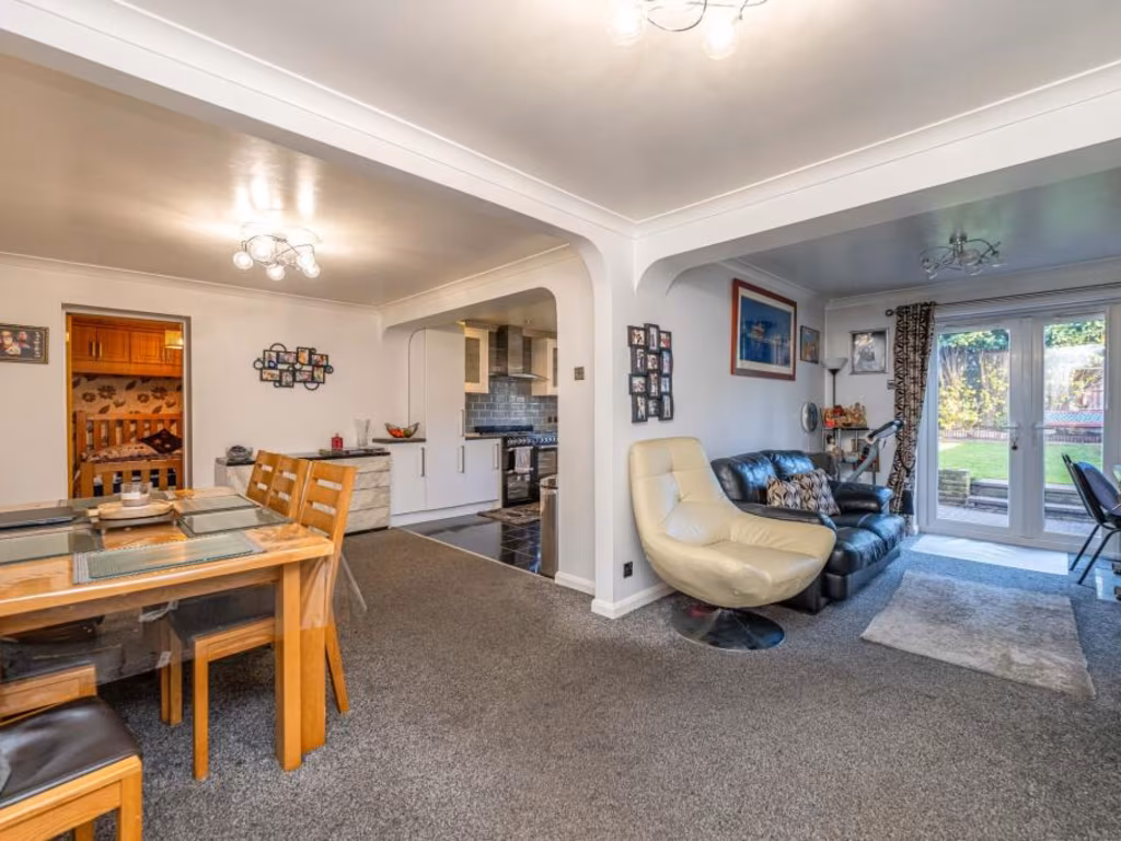
Rooms
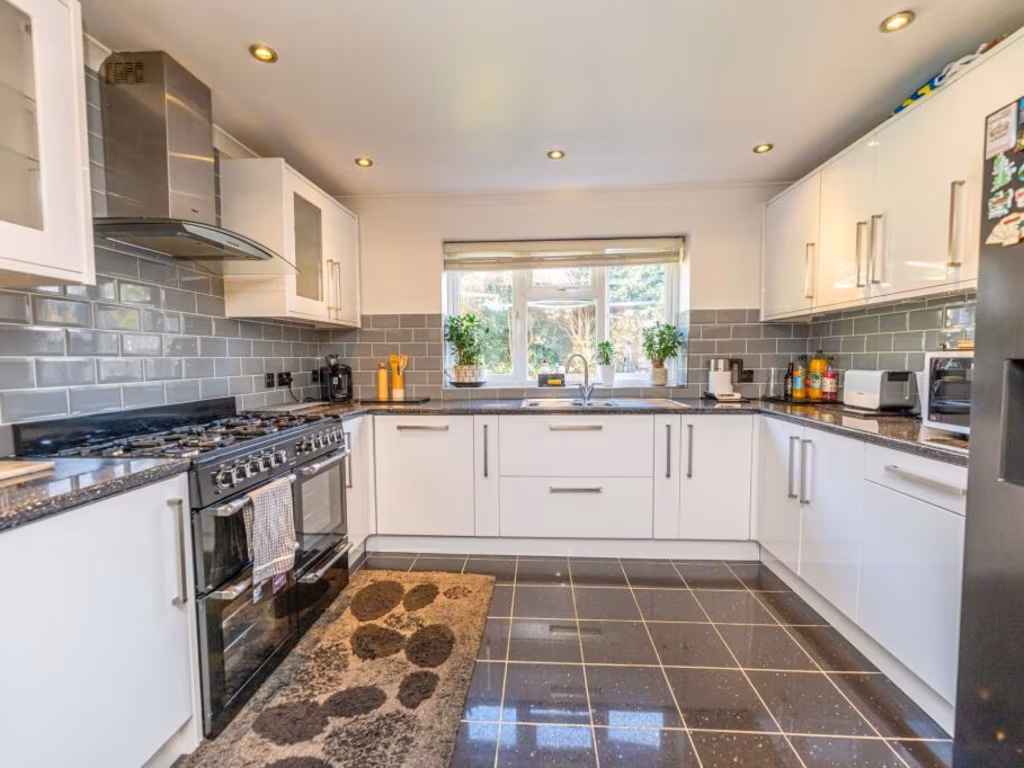
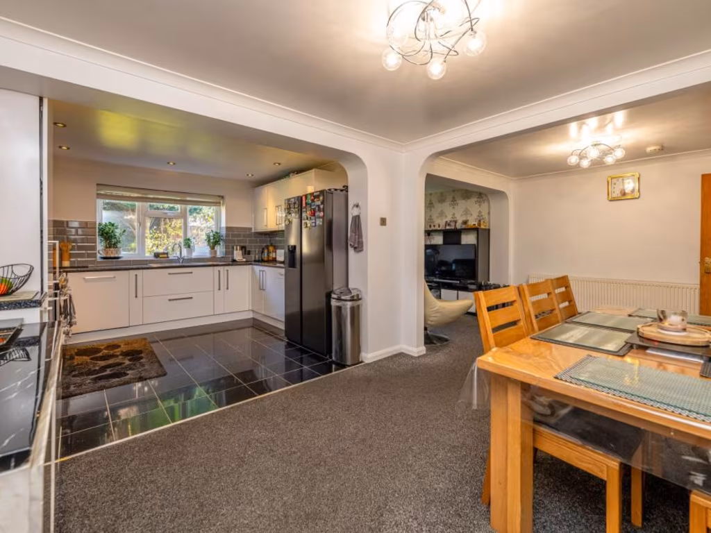
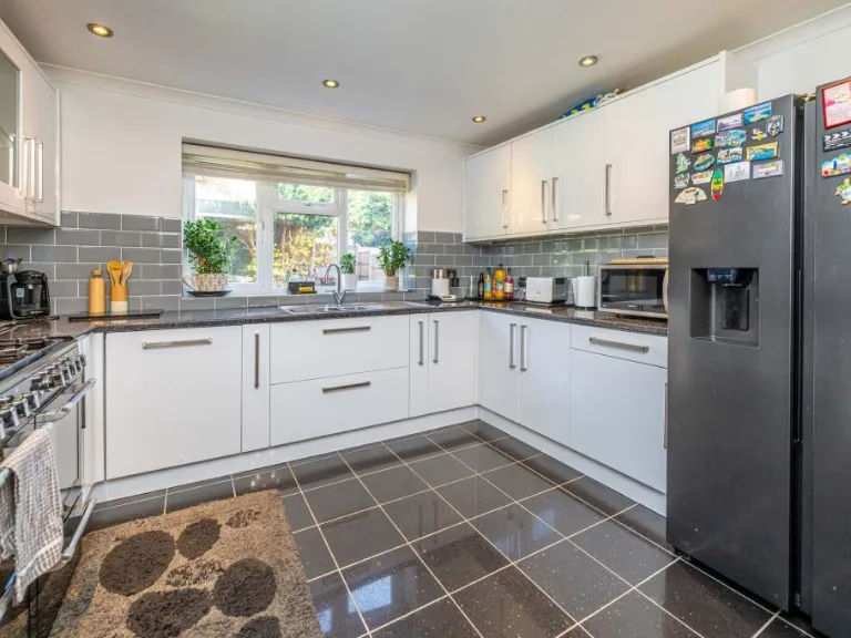
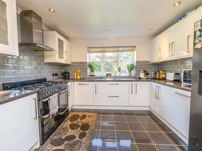
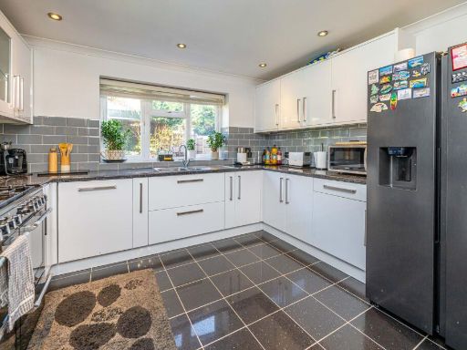
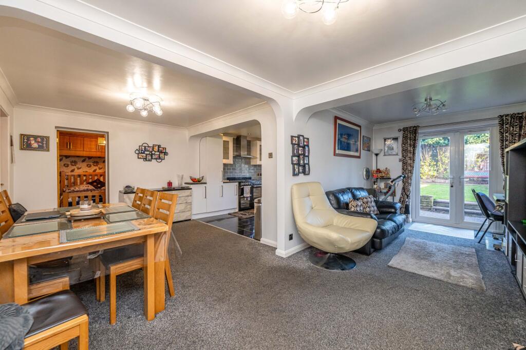
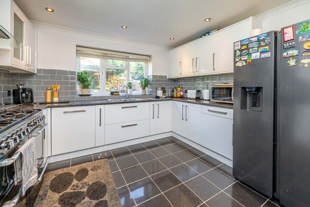
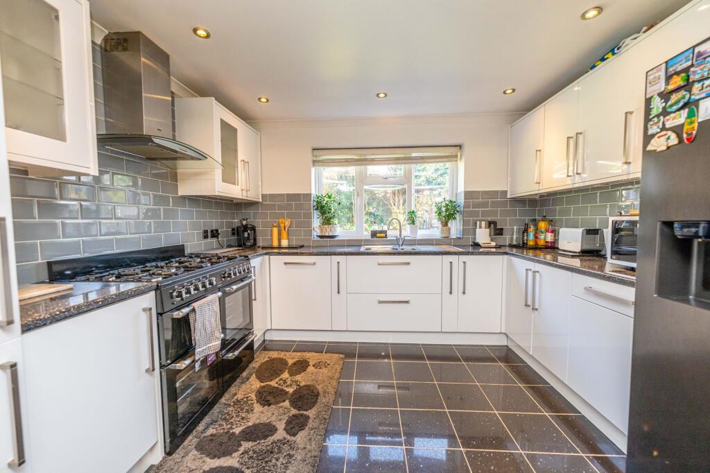
- Kitchen:
- Sitting Room:
- Dining Area:
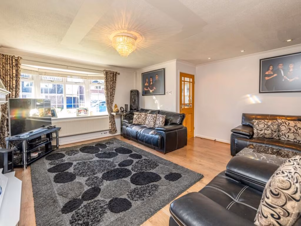
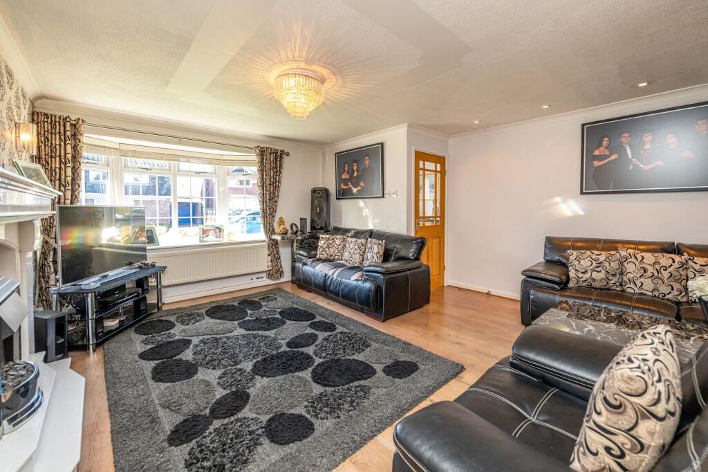
- Living Room:
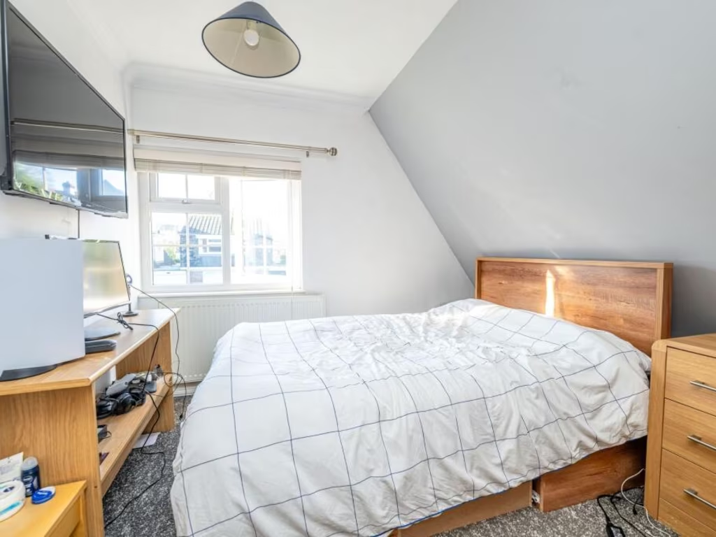
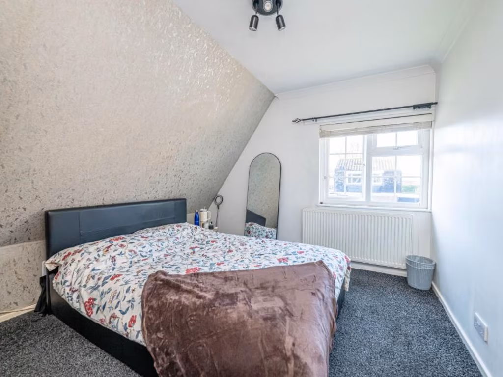
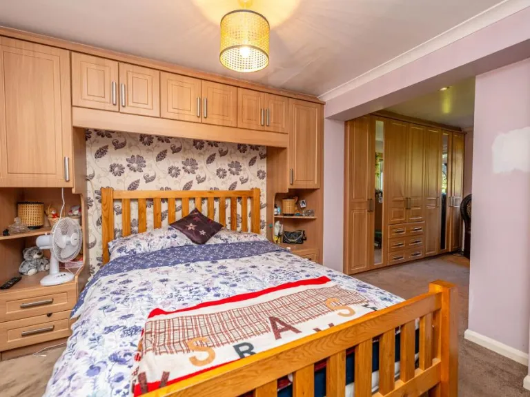
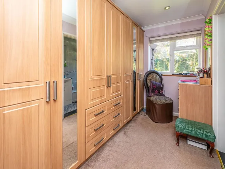
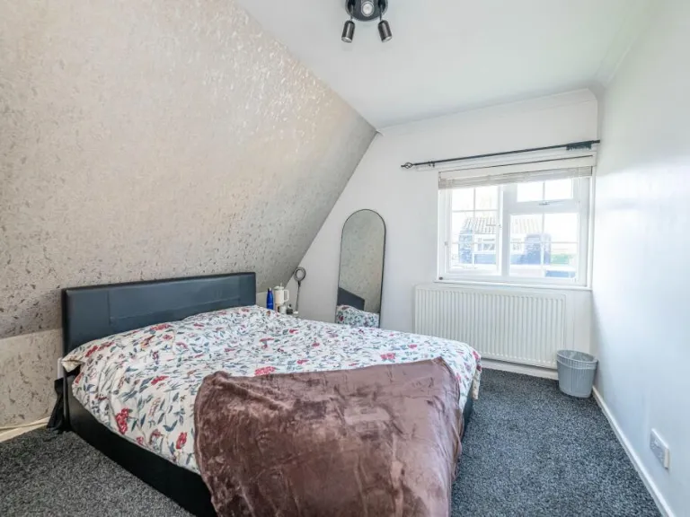
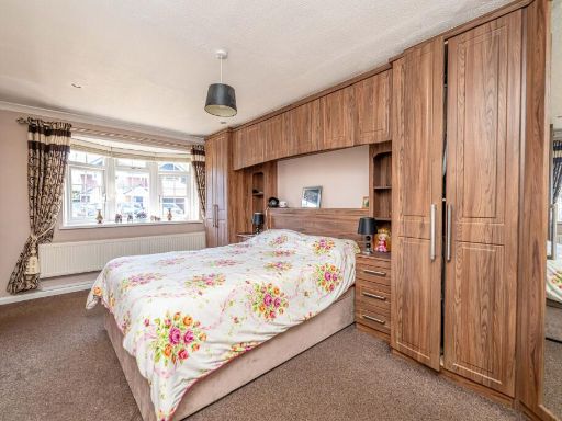
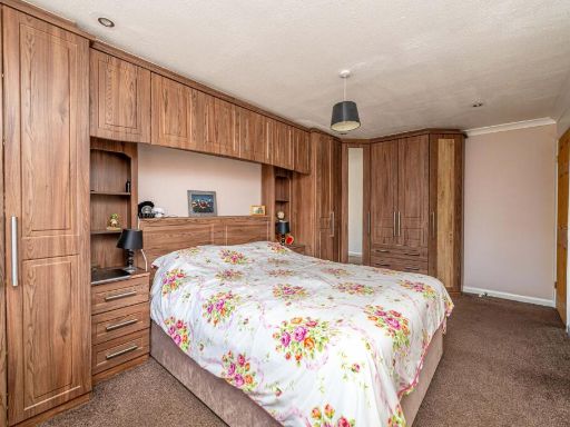
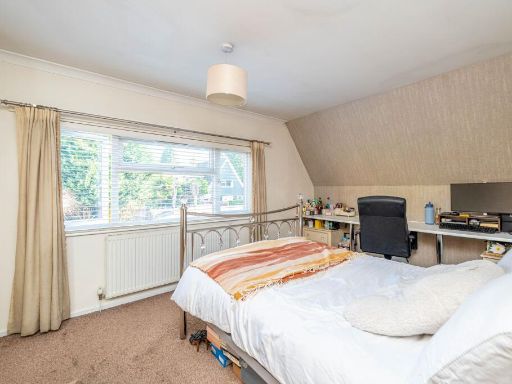
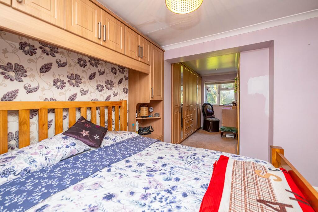
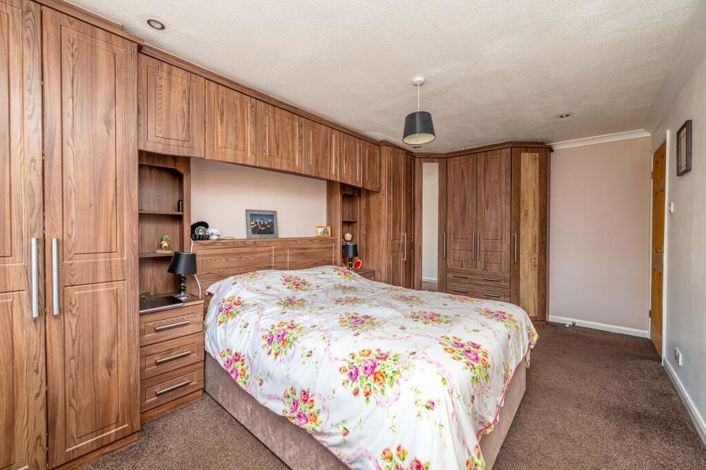
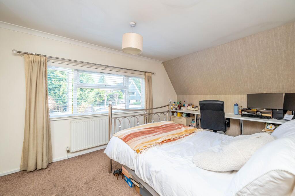
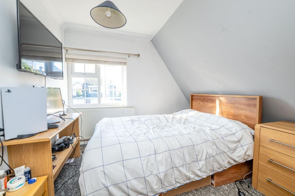
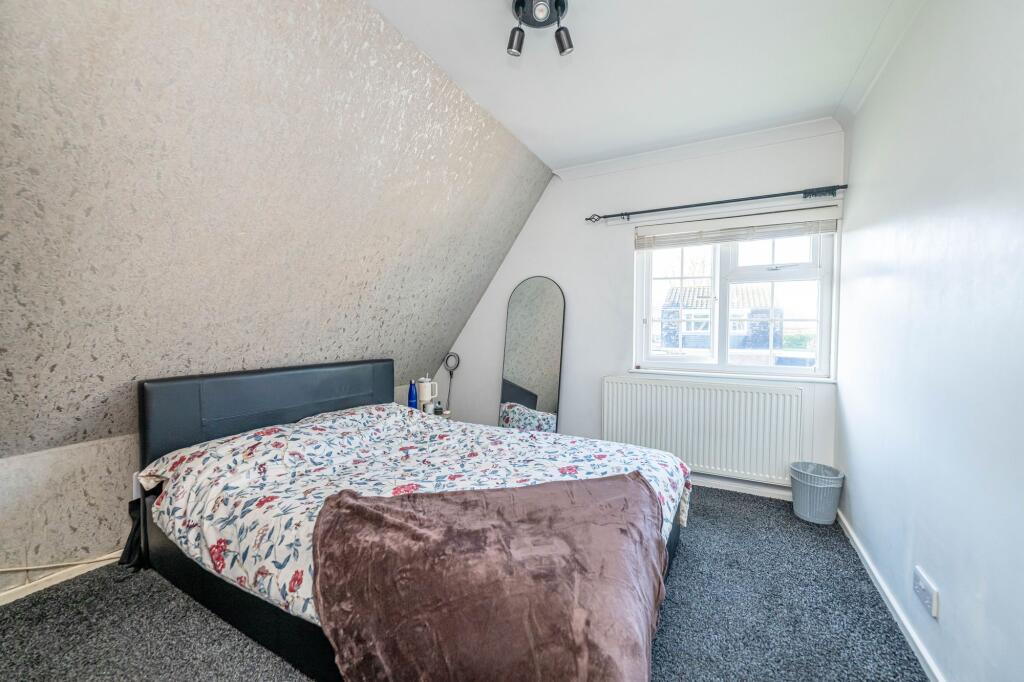
- Bedroom:
- Bedroom:
- Bedroom:
- Bedroom:
- Bedroom:
Textual Property Features
Detected Visual Features
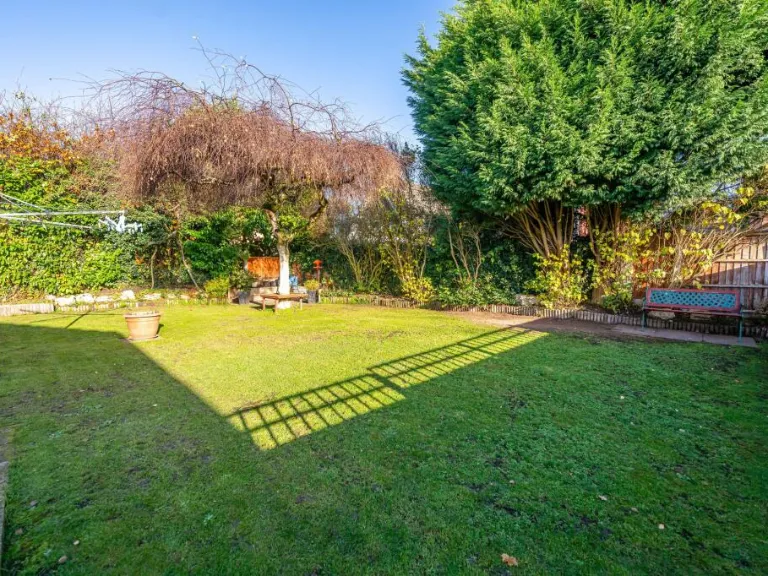
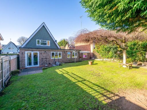
- detached house
- 1960s
- chalet-style
- sloped roof
- garage
- garden
- driveway
- modern
- living room
- bay window
- feature fireplace
- wood laminate flooring
- chandelier
- pattern wallpaper
- light fixtures
- ceiling design
EPC Details
- Fully double glazed
- Timber frame, as built, partial insulation (assumed)
- Boiler and radiators, mains gas
- Low energy lighting in 83% of fixed outlets
- Solid, no insulation (assumed)
Nearby Schools
- Woodfield Primary School
- Nishkam Primary School Wolverhampton
- Wolverhampton Girls' High School
- West Park Primary School
- Tettenhall College Incorporated
- SS Peter and Paul Catholic Primary Academy & Nursery
- Bhylls Acre Primary School
- Bantock Primary School
- Westacre Infant School
- St Peter's Collegiate Academy
- St Jude's Church of England Primary Academy
- Christ Church (Church of England) Infant and Nursery School
- St Edmund's Catholic Academy
- St Michael's Church of England Aided Primary School
- Castlecroft Primary School
- Wolverhampton Grammar School
- Newbridge Preparatory School
- Evergreen Academy
- Claregate Primary School
- Warstones Primary School
- The Royal School, Wolverhampton
- St Michael's Catholic Primary Academy and Nursery
- Uplands Junior School
- Merridale Primary School
- Christ Church (Church of England) Junior School
- St Andrew's Church of England Primary School
Nearest Bars And Restaurants
- Id: 319995912
- Tags:
- Addr:
- City: Wolverhampton
- Housenumber: 19
- Postcode: WV6 0DW
- Street: Riches Street
- Amenity: pub
- Building: pub
- Name: The Newhampton
- Source:
- TagsNormalized:
- Lat: 52.5939101
- Lon: -2.1499803
- FullGeoHash: gcq7pn6mtz6q
- PartitionGeoHash: gcq7
- Images:
- FoodStandards: null
- Distance: 934.1
,- Id: 181782274
- Tags:
- Addr:
- City: Wolverhampton
- Housenumber: 7
- Postcode: WV3 0UN
- Street: Aspen Way
- Amenity: fast_food
- Building: retail
- Name: Fat Daddies
- TagsNormalized:
- Lat: 52.5821002
- Lon: -2.1482653
- FullGeoHash: gcq7ph78vvcm
- PartitionGeoHash: gcq7
- Images:
- FoodStandards: null
- Distance: 910.6
,- Id: 3235861345
- Tags:
- Amenity: cafe
- Source: survey
- TagsNormalized:
- Lat: 52.5799954
- Lon: -2.1545453
- FullGeoHash: gcq7ngzhemw9
- PartitionGeoHash: gcq7
- Images:
- FoodStandards: null
- Distance: 862.5
,- Id: 317383003
- Tags:
- Addr:
- City: Wolverhampton
- Housenumber: 113
- Postcode: WV3 9SE
- Street: Merridale Road
- Amenity: pub
- Building: yes
- Name: The Chindit
- Source: survey
- TagsNormalized:
- Lat: 52.5834232
- Lon: -2.1477413
- FullGeoHash: gcq7phs0dh81
- PartitionGeoHash: gcq7
- Images:
- FoodStandards: null
- Distance: 854.3
,- Id: 296216306
- Tags:
- Addr:
- Housenumber: 136
- Street: Tettenhall Road
- Amenity: restaurant
- Building: yes
- Cuisine: indian
- Name: Mother India
- Opening_hours: Mo-Su 18:00-00:00
- Phone: +44 1902 750755
- Source: bing
- Website: http://www.mother-india.co.uk
- TagsNormalized:
- Lat: 52.5944543
- Lon: -2.1551753
- FullGeoHash: gcq7nyw8uubu
- PartitionGeoHash: gcq7
- Images:
- FoodStandards: null
- Distance: 823.6
}
Nearest General Shops
- Id: 320055240
- Tags:
- Addr:
- City: Wolverhampton
- Housenumber: 9
- Postcode: WV6 0EE
- Street: Newbridge Street
- Building: retail
- Name: Neils Autos
- Shop: car_repair
- Source:
- TagsNormalized:
- retail
- car repair
- repair
- shop
- Lat: 52.5938078
- Lon: -2.1513489
- FullGeoHash: gcq7pn3mjumg
- PartitionGeoHash: gcq7
- Images:
- FoodStandards: null
- Distance: 869.9
,- Id: 296216304
- Tags:
- Addr:
- City: Wolverhampton
- Housenumber: 140b
- Postcode: WV6 0BQ
- Street: Tettenhall Road
- Building: yes
- Shop: interior_decoration
- Source: bing
- TagsNormalized:
- Lat: 52.5947705
- Lon: -2.1548071
- FullGeoHash: gcq7nywftrg6
- PartitionGeoHash: gcq7
- Images:
- FoodStandards: null
- Distance: 864.5
,- Id: 316774783
- Tags:
- Addr:
- City: Wolverhampton
- Housenumber: 80
- Postcode: WV3 9RH
- Street: Merridale Road
- Building: retail
- Name: Beauty Revived Spa
- Shop: beauty
- Source: bing
- TagsNormalized:
- Lat: 52.5833767
- Lon: -2.1487185
- FullGeoHash: gcq7phe275zk
- PartitionGeoHash: gcq7
- Images:
- FoodStandards: null
- Distance: 801.1
}
Nearest Grocery shops
- Id: 296133696
- Tags:
- Building: retail
- Shop: convenience
- Source: bing
- TagsNormalized:
- Lat: 52.5885275
- Lon: -2.1477002
- FullGeoHash: gcq7pjkn6un9
- PartitionGeoHash: gcq7
- Images:
- FoodStandards: null
- Distance: 748.8
,- Id: 559267087
- Tags:
- Addr:
- City: Wolverhampton
- Housenumber: 1e
- Postcode: WV3 9NW
- Street: Clark Road
- Alcohol: yes
- Brand: Premier
- Brand:wikidata: Q7240340
- Brand:wikipedia: en:Premier Stores
- Building: retail
- Name: Premier Tettenhall Supermarket
- Shop: convenience
- Source: bing
- TagsNormalized:
- premier
- retail
- convenience
- shop
- Lat: 52.5888088
- Lon: -2.1480389
- FullGeoHash: gcq7pjeb506p
- PartitionGeoHash: gcq7
- Images:
- FoodStandards: null
- Distance: 732.6
,- Id: 606786297
- Tags:
- TagsNormalized:
- Lat: 52.5887102
- Lon: -2.1480993
- FullGeoHash: gcq7pj7z3wj5
- PartitionGeoHash: gcq7
- Images:
- FoodStandards: null
- Distance: 726.2
}
Nearest Supermarkets
- Id: 56631798
- Tags:
- Brand: Tesco
- Brand:wikidata: Q487494
- Brand:wikipedia: en:Tesco
- Building: yes
- Contact:
- Website: https://www.tesco.com/store-locator/wolverhampton/marston-road
- Name: Tesco
- Shop: supermarket
- Source: OS_OpenData_StreetView
- TagsNormalized:
- Lat: 52.5759041
- Lon: -2.1338325
- FullGeoHash: gcq7p7nhy4gh
- PartitionGeoHash: gcq7
- Images:
- FoodStandards: null
- Distance: 2102.9
,- Id: 294026350
- Tags:
- Brand: Sainsbury's
- Brand:wikidata: Q152096
- Brand:wikipedia: en:Sainsbury's
- Building: retail
- Name: Sainsbury's
- Opening_hours: Mo-Sa 07:00-23:00; Su 11:00-17:00
- Shop: supermarket
- Source: bing
- Wheelchair: yes
- TagsNormalized:
- sainsburys
- retail
- supermarket
- shop
- Lat: 52.5828391
- Lon: -2.1351755
- FullGeoHash: gcq7pkmjnz9v
- PartitionGeoHash: gcq7
- Images:
- FoodStandards: null
- Distance: 1660.9
,- Id: 297417224
- Tags:
- Addr:
- Country: GB
- Postcode: WV3 9EN
- Street: Finchfield Hill
- Brand: Lidl
- Brand:wikidata: Q151954
- Brand:wikipedia: en:Lidl
- Building: retail
- Fhrs:
- Name: Lidl
- Shop: supermarket
- Source: bing
- TagsNormalized:
- lidl
- retail
- supermarket
- shop
- Lat: 52.5809201
- Lon: -2.1725114
- FullGeoHash: gcq7ns440cfj
- PartitionGeoHash: gcq7
- Images:
- FoodStandards:
- Id: 784446
- FHRSID: 784446
- LocalAuthorityBusinessID: 30035
- BusinessName: Lidl
- BusinessType: Retailers - supermarkets/hypermarkets
- BusinessTypeID: 7840
- AddressLine1: Finchfield Hill
- AddressLine2: Wolverhampton
- AddressLine3: West Midlands
- AddressLine4: null
- PostCode: WV3 9EN
- RatingValue: 5
- RatingKey: fhrs_5_en-GB
- RatingDate: 2018-12-04
- LocalAuthorityCode: 436
- LocalAuthorityName: Wolverhampton
- LocalAuthorityWebSite: http://www.wolverhampton.gov.uk/
- LocalAuthorityEmailAddress: customer.services@wolverhampton.gov.uk
- Scores:
- Hygiene: 0
- Structural: 5
- ConfidenceInManagement: 0
- NewRatingPending: false
- Geocode:
- Longitude: -2.17217000000000
- Latitude: 52.58201500000000
- Distance: 1180.1
}
Nearest Religious buildings
- Id: 95131555
- Tags:
- Addr:
- City: Wolverhampton
- Housenumber: 187
- Postcode: WV6 0RW
- Street: Newhampton Road West
- Amenity: place_of_worship
- Building: yes
- Denomination: jehovahs_witness
- Name: Kingdom Hall of Jehovah's Witnesses
- Religion: christian
- TagsNormalized:
- place of worship
- jehovah
- jehovahs witness
- christian
- church
- Lat: 52.5959474
- Lon: -2.1565101
- FullGeoHash: gcq7nyv9tejx
- PartitionGeoHash: gcq7
- Images:
- FoodStandards: null
- Distance: 966.7
,- Id: 296133683
- Tags:
- Amenity: place_of_worship
- Building: church
- Denomination: anglican
- Heritage: 2
- Heritage:operator: Historic England
- Listed_status: Grade II
- Name: St Jude's
- Religion: christian
- Wikidata: Q26503613
- TagsNormalized:
- place of worship
- church
- anglican
- christian
- Lat: 52.5922815
- Lon: -2.1522675
- FullGeoHash: gcq7pn0u0xc5
- PartitionGeoHash: gcq7
- Images:
- FoodStandards: null
- Distance: 696.2
,- Id: 47594235
- Tags:
- Addr:
- Amenity: school
- Name: St Peter's Collegiate Church of England School
- Ref:
- Source:
- Addr:
- Postcode: get-information-schools.service.gov.uk
- Url: http://www.speters.org.uk/
- TagsNormalized:
- Lat: 52.5911903
- Lon: -2.1587106
- FullGeoHash: gcq7nvujfkkt
- PartitionGeoHash: gcq7
- Images:
- FoodStandards: null
- Distance: 427.3
}
Nearest Medical buildings
- Id: 558588260
- Tags:
- Addr:
- City: Wolverhampton
- Housenumber: 199
- Postcode: WV6 0DD
- Street: Tettenhall Road
- Amenity: doctors
- Building: residential
- Healthcare: doctor
- Name: Dr Nicola Whitehouse
- Source: bing
- TagsNormalized:
- doctor
- doctors
- residential
- health
- healthcare
- Lat: 52.5921514
- Lon: -2.1534545
- FullGeoHash: gcq7nypgkzeg
- PartitionGeoHash: gcq7
- Images:
- FoodStandards: null
- Distance: 637.8
,- Id: 296133704
- Tags:
- Addr:
- City: Wolverhampton
- Housenumber: 197
- Postcode: WV6 0BZ
- Street: Tettenhall Road
- Amenity: clinic
- Building: yes
- Healthcare: clinic
- Name: Geoff Hale City Osteopaths
- Source: bing
- TagsNormalized:
- Lat: 52.5920388
- Lon: -2.1532782
- FullGeoHash: gcq7pn04bfx7
- PartitionGeoHash: gcq7
- Images:
- FoodStandards: null
- Distance: 634
,- Id: 5394134895
- Tags:
- Amenity: dentist
- Healthcare: dentist
- Name: Smileworks Dentistry
- TagsNormalized:
- dentist
- health
- healthcare
- dentistry
- Lat: 52.5902409
- Lon: -2.1506824
- FullGeoHash: gcq7pjcbm7qy
- PartitionGeoHash: gcq7
- Images:
- FoodStandards: null
- Distance: 624.9
,- Id: 296133693
- Tags:
- Addr:
- City: Wolverhampton
- Housename: Halfway House
- Postcode: WV3 9NJ
- Street: Tettenhall Road
- Amenity: pharmacy
- Building: yes
- Healthcare: pharmacy
- Name: Mill Stream Pharmacy
- Source: bing
- TagsNormalized:
- pharmacy
- health
- healthcare
- stream
- Lat: 52.590273
- Lon: -2.1507788
- FullGeoHash: gcq7pjcbe1rn
- PartitionGeoHash: gcq7
- Images:
- FoodStandards: null
- Distance: 621.2
}
Nearest Leisure Facilities
- Id: 674983021
- Tags:
- Leisure: pitch
- Lit: yes
- Sport: tennis
- Surface: asphalt
- TagsNormalized:
- Lat: 52.5889803
- Lon: -2.1636163
- FullGeoHash: gcq7nv89006y
- PartitionGeoHash: gcq7
- Images:
- FoodStandards: null
- Distance: 383.7
,- Id: 157929770
- Tags:
- TagsNormalized:
- Lat: 52.5898319
- Lon: -2.1549474
- FullGeoHash: gcq7nvwvfp4y
- PartitionGeoHash: gcq7
- Images:
- FoodStandards: null
- Distance: 371
,- Id: 157929773
- Tags:
- TagsNormalized:
- Lat: 52.5905195
- Lon: -2.1570368
- FullGeoHash: gcq7nvv3crku
- PartitionGeoHash: gcq7
- Images:
- FoodStandards: null
- Distance: 368.4
,- Id: 1053239543
- Tags:
- Leisure: pitch
- Sport: soccer
- TagsNormalized:
- Lat: 52.5852431
- Lon: -2.1547782
- FullGeoHash: gcq7nuygnpbc
- PartitionGeoHash: gcq7
- Images:
- FoodStandards: null
- Distance: 349.1
,- Id: 47595345
- Tags:
- TagsNormalized:
- Lat: 52.5892187
- Lon: -2.1602879
- FullGeoHash: gcq7nvdfmsus
- PartitionGeoHash: gcq7
- Images:
- FoodStandards: null
- Distance: 236.8
}
Nearest Tourist attractions
- Id: 405379954
- Tags:
- Addr:
- Building: yes
- Name: Tettenhall Transport Heritage Museum
- Tourism: museum
- TagsNormalized:
- Lat: 52.5966433
- Lon: -2.1623822
- FullGeoHash: gcq7nycmsufy
- PartitionGeoHash: gcq7
- Images:
- FoodStandards: null
- Distance: 1064.5
,- Id: 1107967370
- Tags:
- Name: Bantock House
- Tourism: museum
- Wikidata: Q4857244
- TagsNormalized:
- Lat: 52.5799991
- Lon: -2.1541891
- FullGeoHash: gcq7ngzkey0p
- PartitionGeoHash: gcq7
- Images:
- FoodStandards: null
- Distance: 870.1
,- Id: 296216299
- Tags:
- Addr:
- City: Wolverhampton
- Housename: Revelstoke
- Housenumber: 124
- Postcode: WV6 0BL
- Street: Tettenhall Road
- Building: residential
- Name: Revelstoke Guest House
- Source: bing
- Tourism: guest_house
- TagsNormalized:
- residential
- guest house
- tourism
- Lat: 52.5936736
- Lon: -2.1542505
- FullGeoHash: gcq7nyrk6767
- PartitionGeoHash: gcq7
- Images:
- FoodStandards: null
- Distance: 762.6
}
Nearest Train stations
- Id: 21137911
- Tags:
- Name: Tipton
- Naptan:
- Network: National Rail
- Public_transport: station
- Railway: station
- Ref:
- Source: NPE
- West_midlands_fare_zone: 5
- Wikidata: Q2660685
- Wikipedia: en:Tipton railway station
- TagsNormalized:
- Lat: 52.5305353
- Lon: -2.0658086
- FullGeoHash: gcqdbfzsx1t2
- PartitionGeoHash: gcqd
- Images:
- FoodStandards: null
- Distance: 8903.1
,- Id: 8183358952
- Tags:
- Name: Coseley
- Naptan:
- Network: National Rail
- Public_transport: station
- Railway: station
- Ref:
- West_midlands_fare_zone: 5
- Wikidata: Q2239840
- Wikipedia: en:Coseley railway station
- TagsNormalized:
- Lat: 52.5453191
- Lon: -2.0858098
- FullGeoHash: gcqdbt94tj7m
- PartitionGeoHash: gcqd
- Images:
- FoodStandards: null
- Distance: 6786.3
,- Id: 3711941418
- Tags:
- Name: Codsall
- Naptan:
- Network: National Rail
- Public_transport: station
- Railway: station
- Ref:
- Wikidata: Q2455479
- Wikipedia: en:Codsall railway station
- TagsNormalized:
- Lat: 52.6274199
- Lon: -2.2016755
- FullGeoHash: gcq7musbcnpg
- PartitionGeoHash: gcq7
- Images:
- FoodStandards: null
- Distance: 5320.7
,- Id: 3711941417
- Tags:
- Name: Bilbrook
- Naptan:
- Network: National Rail
- Public_transport: station
- Railway: station
- Ref:
- Wikidata: Q2786231
- Wikipedia: en:Bilbrook railway station
- TagsNormalized:
- Lat: 52.6239645
- Lon: -2.1873052
- FullGeoHash: gcq7q5zkb1gp
- PartitionGeoHash: gcq7
- Images:
- FoodStandards: null
- Distance: 4509.1
,- Id: 6634567442
- Tags:
- Name: Wolverhampton
- Naptan:
- Network: National Rail
- Old_name: Wolverhampton High Level
- Public_transport: station
- Railway: station
- Ref:
- West_midlands_fare_zone: 5
- Wheelchair: yes
- Wikidata: Q2361188
- Wikipedia: en:Wolverhampton railway station
- TagsNormalized:
- Lat: 52.5879884
- Lon: -2.120242
- FullGeoHash: gcq7pv254z8c
- PartitionGeoHash: gcq7
- Images:
- FoodStandards: null
- Distance: 2593.1
}
Nearest Hotels
- Id: 284967299
- Tags:
- Addr:
- City: Wolverhampton
- Housenumber: 40-50
- Postcode: WV1 4SW
- Street: Tettenhall Road
- Alt_name: Connaught Hotel
- Building: hotel
- Name: Quality Hotel
- Source: visual survey; bing
- Tourism: hotel
- TagsNormalized:
- Lat: 52.5879556
- Lon: -2.1450997
- FullGeoHash: gcq7pjmgp93w
- PartitionGeoHash: gcq7
- Images:
- FoodStandards: null
- Distance: 915.4
,- Id: 296216290
- Tags:
- Addr:
- City: Wolverhampton
- Housenumber: 138
- Postcode: WV6 0BQ
- Street: Tettenhall Road
- Bar: yes
- Building: yes
- Name: The York Hotel
- Restaurant: yes
- Source: bing
- Tourism: hotel
- Website: http://theyorkhotel.com
- TagsNormalized:
- Lat: 52.5946157
- Lon: -2.1553424
- FullGeoHash: gcq7nyw9bfup
- PartitionGeoHash: gcq7
- Images:
- FoodStandards: null
- Distance: 837.8
,- Id: 559226584
- Tags:
- Addr:
- City: Wolverhampton
- Housenumber: 77-79
- Postcode: WV6 0AG
- Street: Albert Road
- Name: Queen Victoria Hotel
- Tourism: hotel
- Website: https://www.thequeenvictoriahotel.co.uk
- TagsNormalized:
- Lat: 52.5908181
- Lon: -2.1502067
- FullGeoHash: gcq7pjf78x19
- PartitionGeoHash: gcq7
- Images:
- FoodStandards: null
- Distance: 686.6
}
Tags
- detached house
- 1960s
- chalet-style
- sloped roof
- garage
- garden
- driveway
- modern
- living room
- bay window
- feature fireplace
- wood laminate flooring
- chandelier
- pattern wallpaper
- light fixtures
- ceiling design
Local Market Stats
- Average Price/sqft: £215
- Avg Income: £41200
- Rental Yield: 3.6%
- Social Housing: 12%
- Planning Success Rate: 91%
AirBnB Data
- 1km average: £105/night
- Listings in 1km: 4
Similar Properties
 4 bedroom detached house for sale in Richmond Avenue, Finchfield, Wolverhampton, WV3 — £395,000 • 4 bed • 1 bath • 1077 ft²
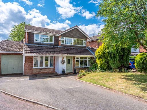 5 bedroom detached house for sale in Cherrington Gardens, Compton, Wolverhampton, WV6 — £475,000 • 5 bed • 3 bath • 1977 ft²
 5 bedroom detached house for sale in Westland Avenue, Compton, Wolverhampton, WV3 — £475,000 • 5 bed • 3 bath • 1303 ft²
 5 bedroom detached house for sale in Bhylls Lane, Merry Hill, Wolverhampton, WV3 — £575,000 • 5 bed • 1 bath • 2069 ft²
 4 bedroom detached house for sale in Dippons Mill Close, Tettenhall Wood, Wolverhampton, WV6 — £550,000 • 4 bed • 3 bath • 1626 ft²
 5 bedroom detached house for sale in 20 Pickwick Gardens, Compton, Wolverhampton, WV3 9EH, WV3 — £1,095,000 • 5 bed • 4 bath • 2701 ft²
Meta
- {
"@context": "https://schema.org",
"@type": "Residence",
"name": "5 bedroom detached house for sale in Ross Close, Wolverhamp…",
"description": "",
"url": "https://propertypiper.co.uk/property/c0825727-a8ed-4fab-951e-cee54548a826",
"image": "https://image-a.propertypiper.co.uk/7f07a4f1-012a-41c7-87a3-16b9cfbd22ce-1024.jpeg",
"address": {
"@type": "PostalAddress",
"streetAddress": "3 ROSS CLOSE WOLVERHAMPTON",
"postalCode": "WV3 9LA",
"addressLocality": "Wolverhampton",
"addressRegion": "Wolverhampton South West",
"addressCountry": "England"
},
"geo": {
"@type": "GeoCoordinates",
"latitude": 52.58734762386758,
"longitude": -2.158612557817172
},
"numberOfRooms": 5,
"numberOfBathroomsTotal": 2,
"floorSize": {
"@type": "QuantitativeValue",
"value": 2076,
"unitCode": "FTK"
},
"offers": {
"@type": "Offer",
"price": 475000,
"priceCurrency": "GBP",
"availability": "https://schema.org/InStock"
},
"additionalProperty": [
{
"@type": "PropertyValue",
"name": "Feature",
"value": "detached house"
},
{
"@type": "PropertyValue",
"name": "Feature",
"value": "1960s"
},
{
"@type": "PropertyValue",
"name": "Feature",
"value": "chalet-style"
},
{
"@type": "PropertyValue",
"name": "Feature",
"value": "sloped roof"
},
{
"@type": "PropertyValue",
"name": "Feature",
"value": "garage"
},
{
"@type": "PropertyValue",
"name": "Feature",
"value": "garden"
},
{
"@type": "PropertyValue",
"name": "Feature",
"value": "driveway"
},
{
"@type": "PropertyValue",
"name": "Feature",
"value": "modern"
},
{
"@type": "PropertyValue",
"name": "Feature",
"value": "living room"
},
{
"@type": "PropertyValue",
"name": "Feature",
"value": "bay window"
},
{
"@type": "PropertyValue",
"name": "Feature",
"value": "feature fireplace"
},
{
"@type": "PropertyValue",
"name": "Feature",
"value": "wood laminate flooring"
},
{
"@type": "PropertyValue",
"name": "Feature",
"value": "chandelier"
},
{
"@type": "PropertyValue",
"name": "Feature",
"value": "pattern wallpaper"
},
{
"@type": "PropertyValue",
"name": "Feature",
"value": "light fixtures"
},
{
"@type": "PropertyValue",
"name": "Feature",
"value": "ceiling design"
}
]
}
High Res Floorplan Images
Compatible Floorplan Images
FloorplanImages Thumbnail