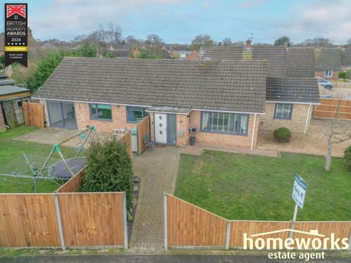
NR19 1JS - 4 bedroom detached bungalow for sale in Stone Road, Toftwoo…
View on Property Piper
4 bedroom detached bungalow for sale in Stone Road, Toftwood, Dereham, NR19
Property Details
- Price: £425000
- Bedrooms: 4
- Bathrooms: 2
- Property Type: undefined
- Property SubType: undefined
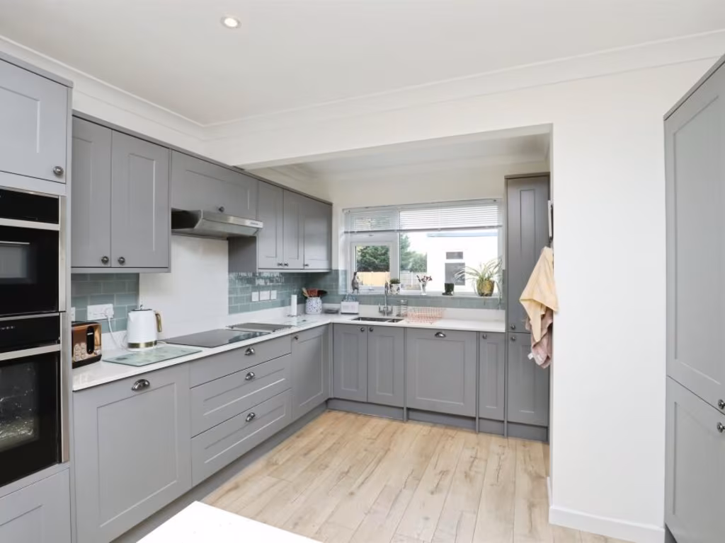
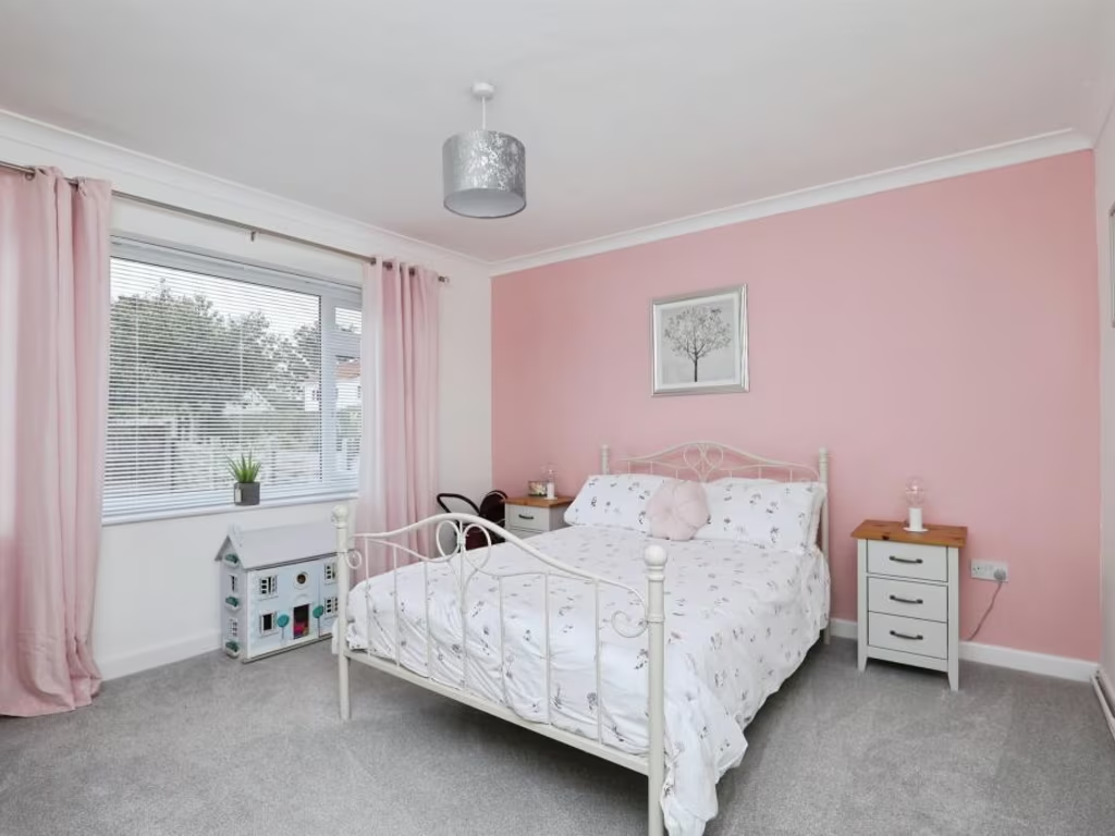
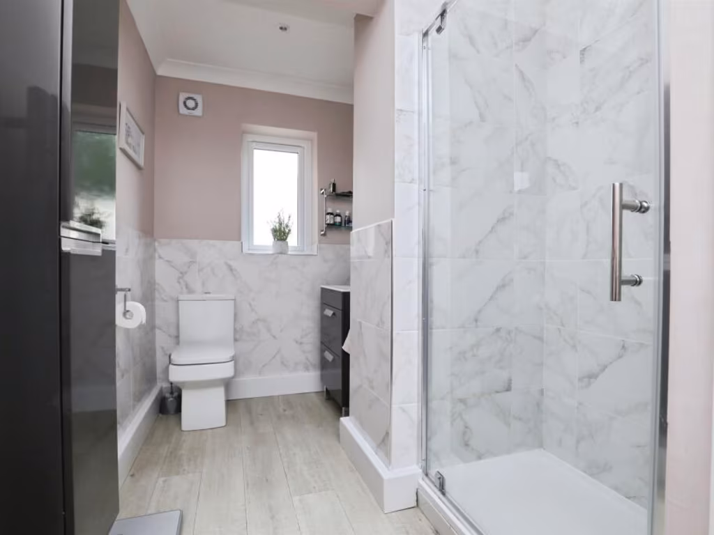
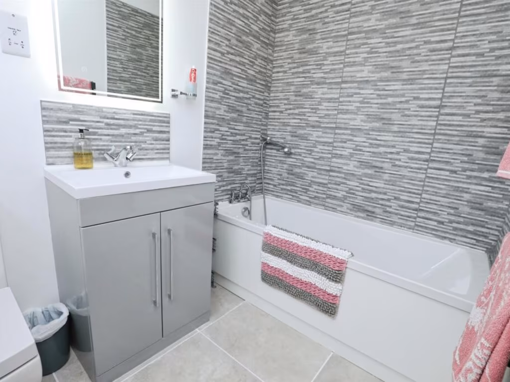
Image Descriptions
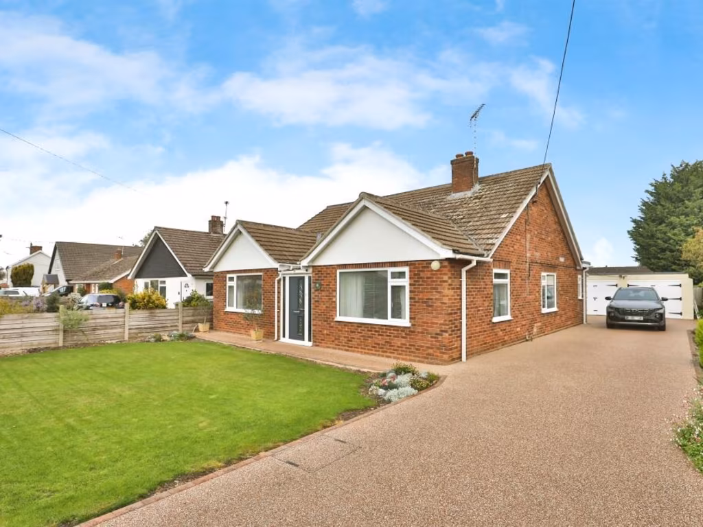
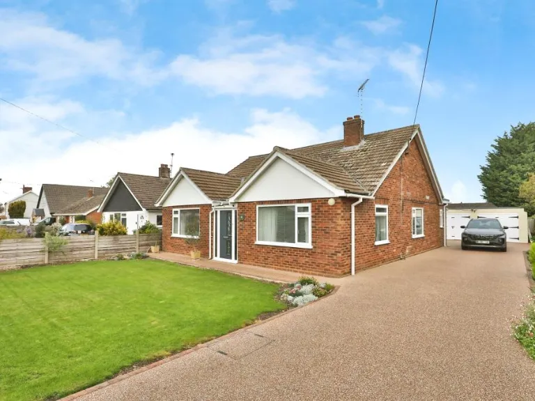
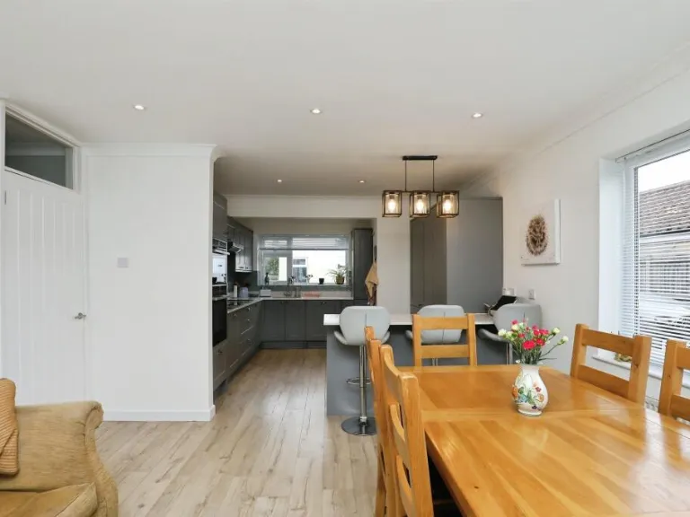
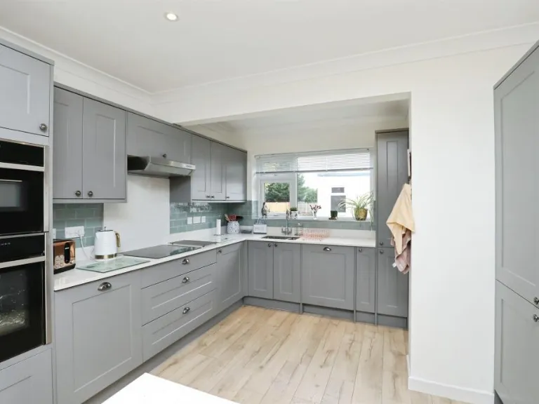
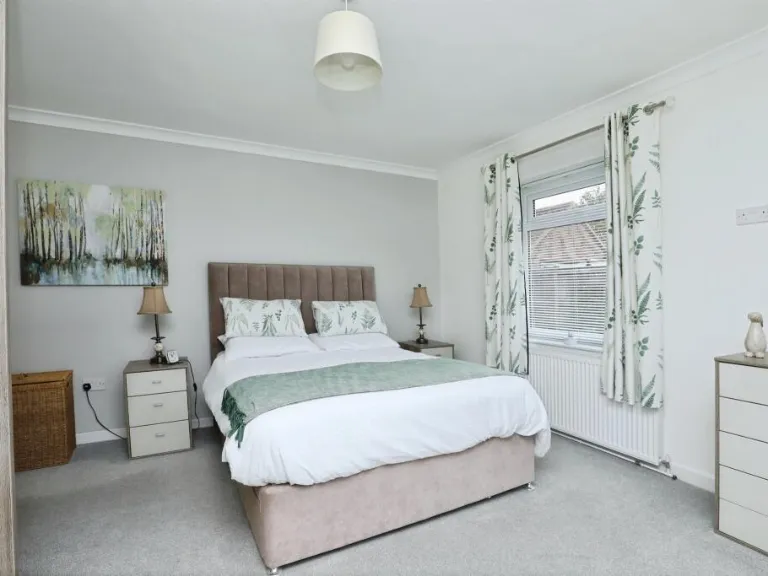
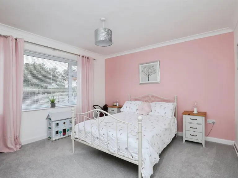
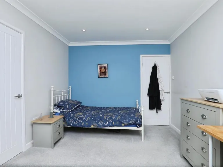
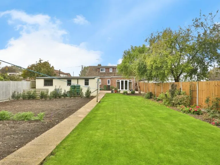
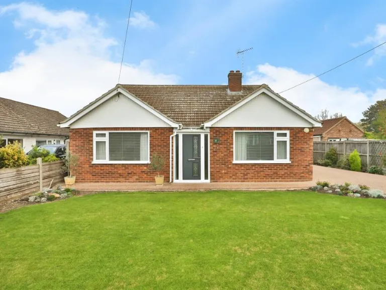
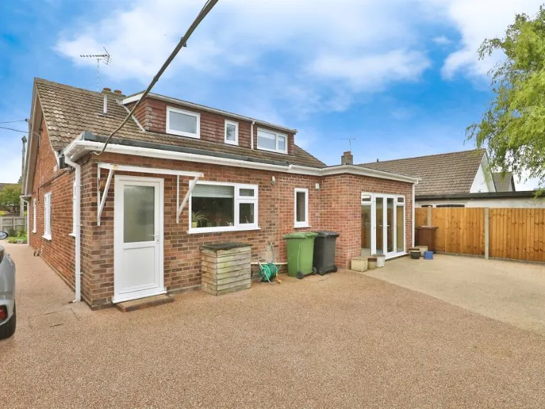
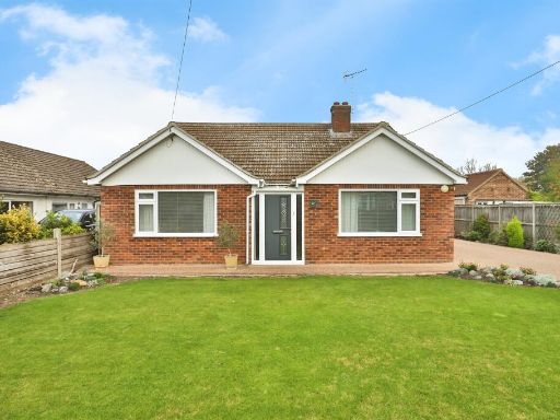
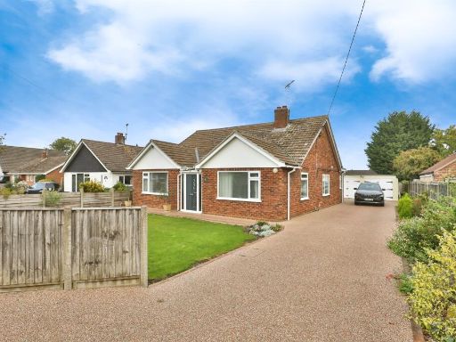
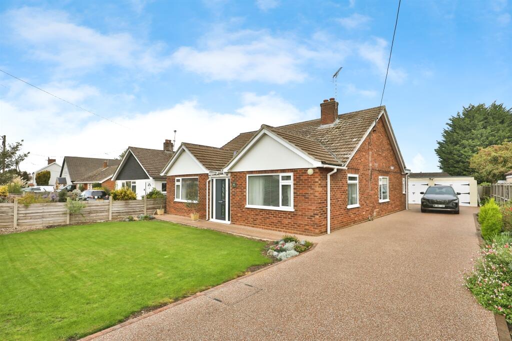
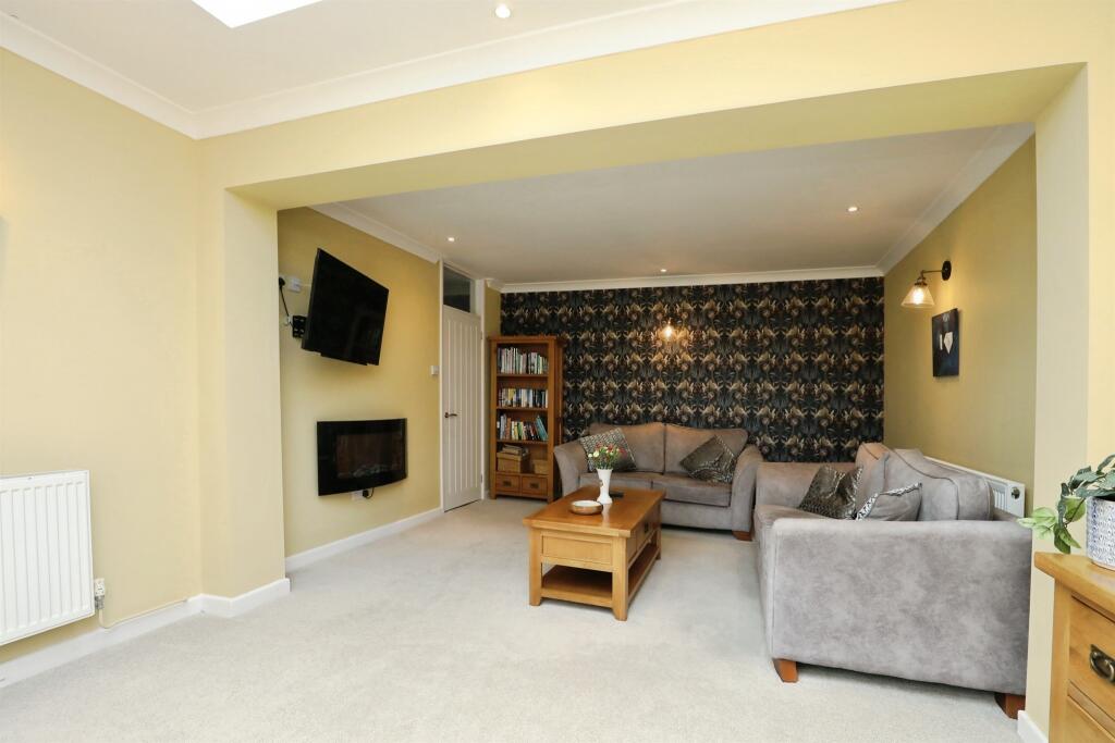
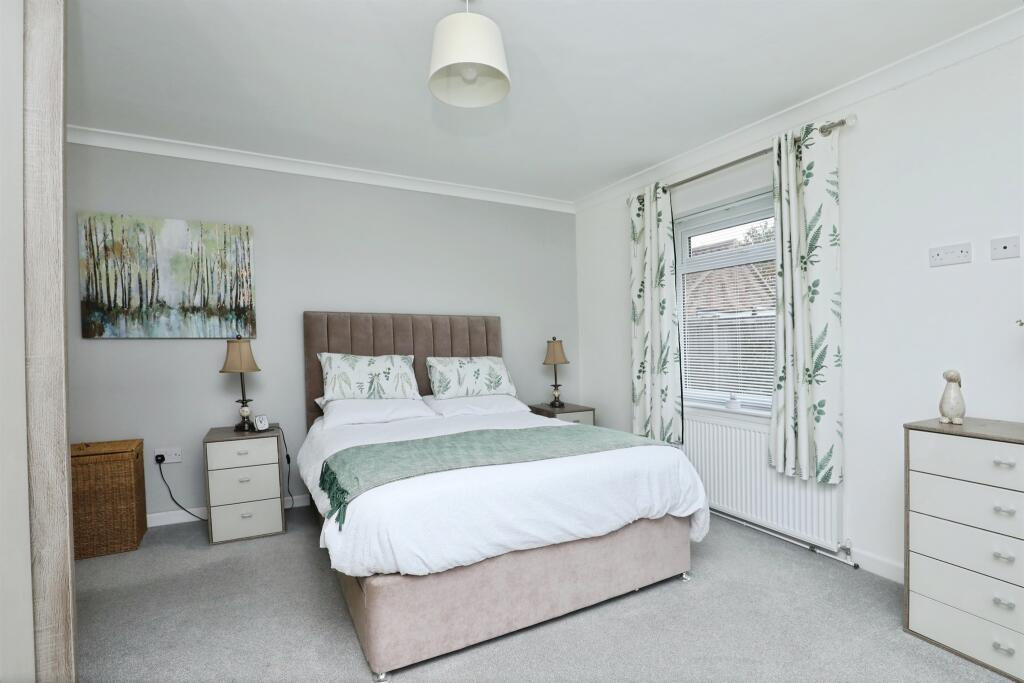
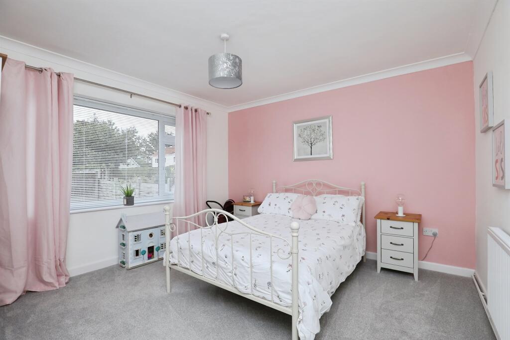
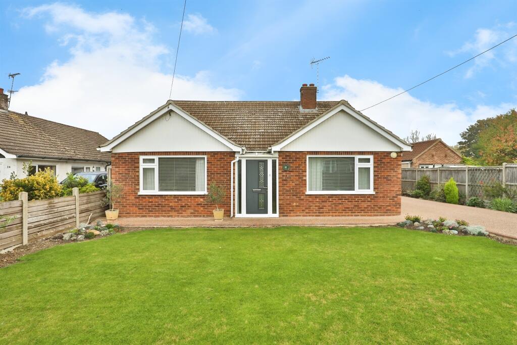
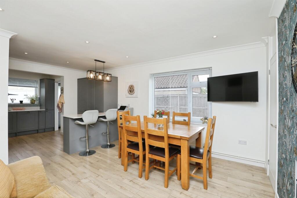
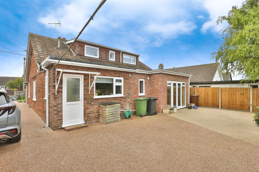
- single-storey house 1950s-mid century
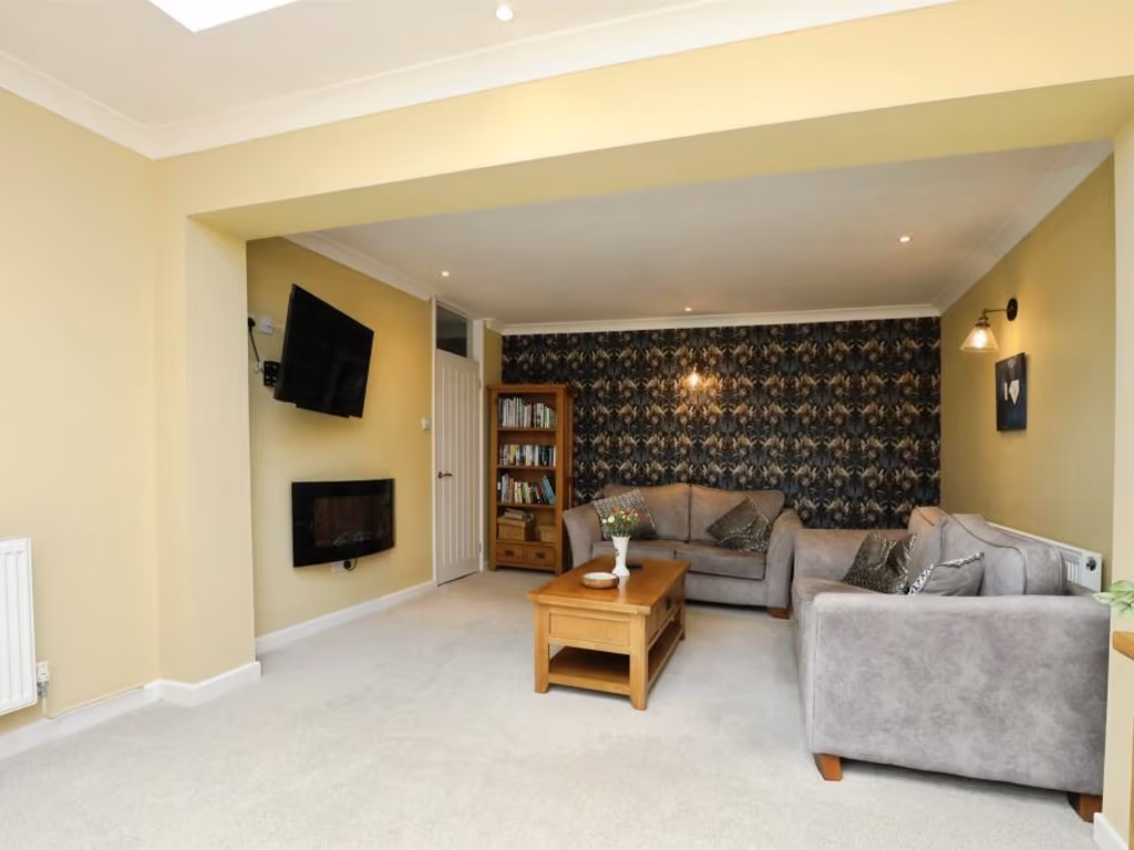
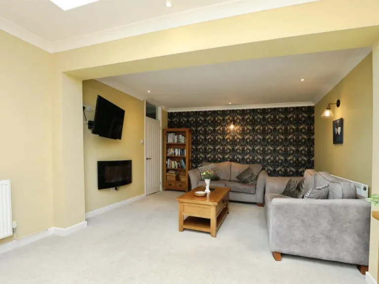
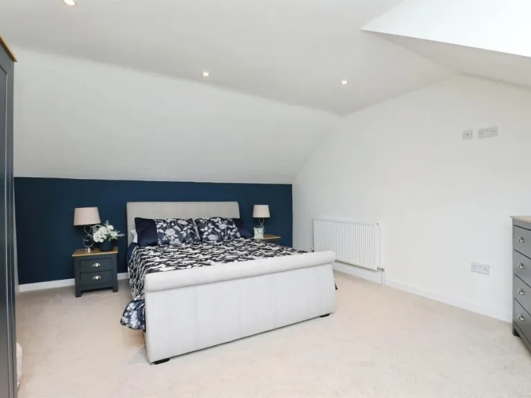
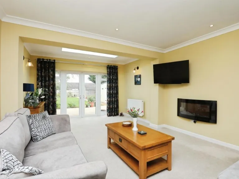
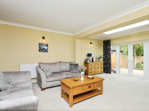
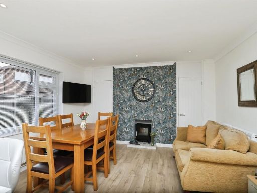
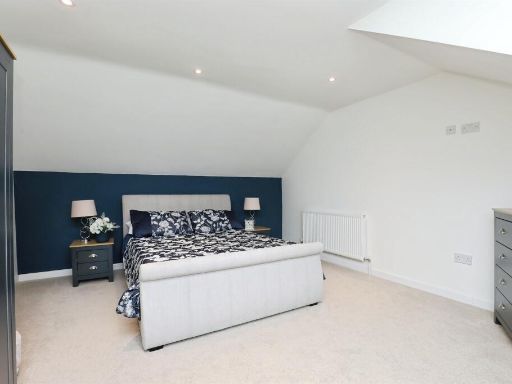
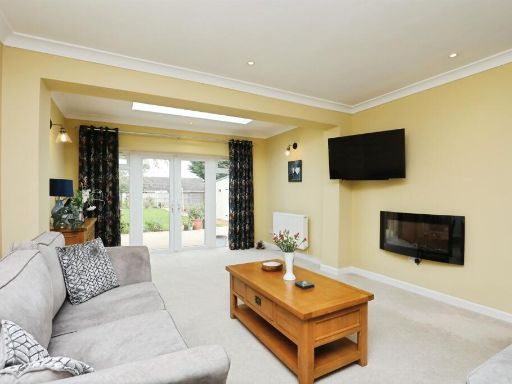
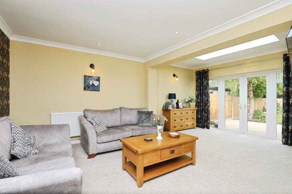
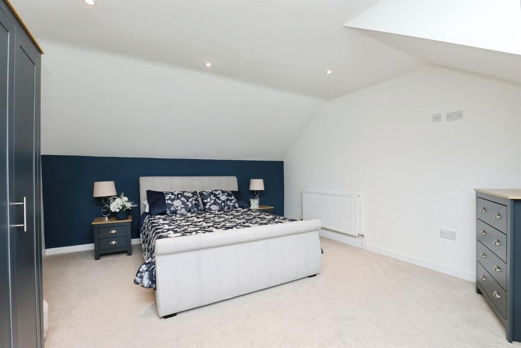
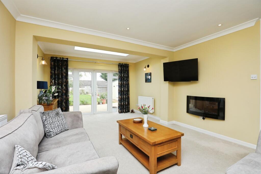
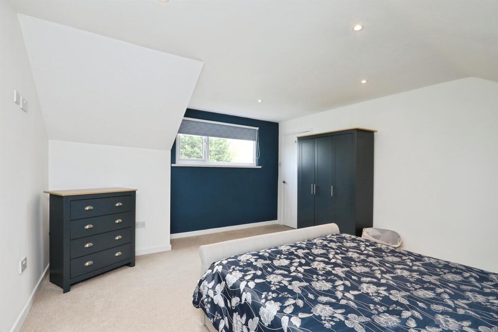
- living room modern
Floorplan Description
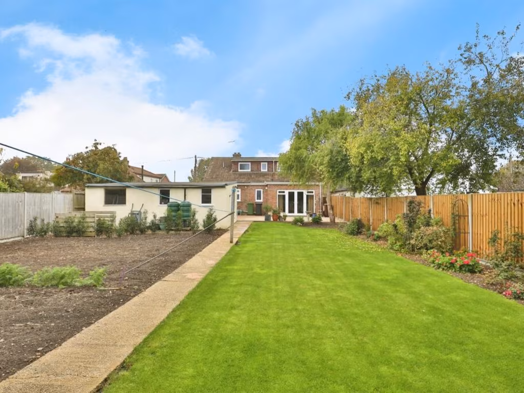
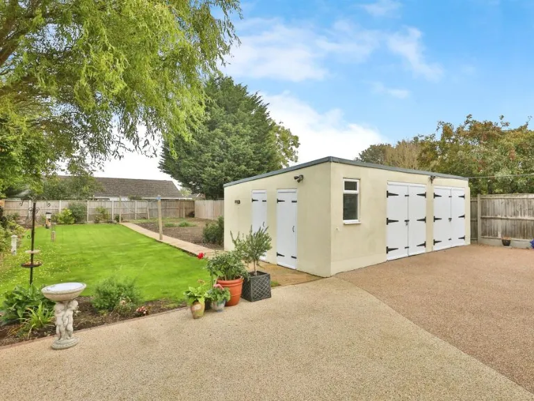
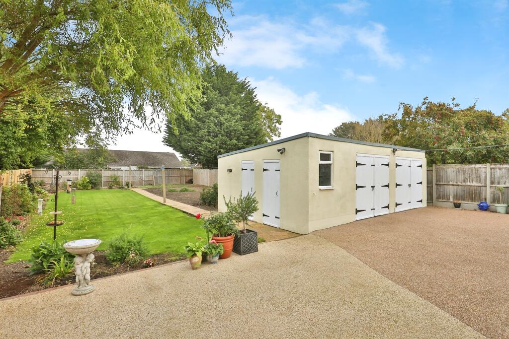
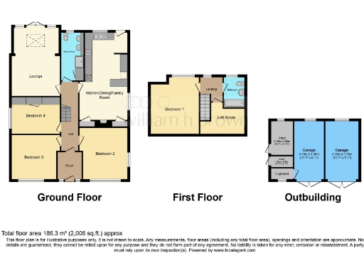
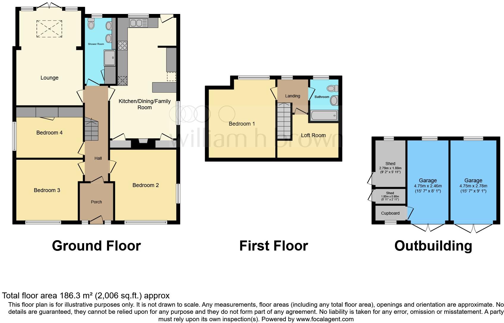
- Two-storey house with outbuilding containing two garages and two sheds
Rooms
- Garage:
- Garage:
- Shed:
- Shed:
Textual Property Features
Detected Visual Features
- 1950s
- mid-century
- detached
- bungalow
- single-storey
- brick facade
- gable roof
- driveway
- front lawn
- well-maintained
- modern
- suburban
- residential
- modern living room
- french doors
- standard ceiling
- skylight
- natural light
- neutral decor
EPC Details
- Fully double glazed
- Cavity wall, filled cavity
- Boiler and radiators, mains gas
- Low energy lighting in 27% of fixed outlets
- Solid, no insulation (assumed)
Nearby Schools
- Mattishall Primary School
- Thomas Bullock Church of England Primary and Nursery Academy
- King's Park Infant School, Dereham
- St Mary's Community Primary School, Beetley
- Dereham Neatherd High School
- Garvestone Community Primary School
- Yaxham Church of England Primary Academy
- Toftwood Infant School
- Scarning Voluntary Controlled Primary School
- Northgate High School
- Swanton Morley VC Primary School
- Dereham, Toftwood Community Junior School
- Dereham Church of England Junior Academy
- Grove House Infant and Nursery School
- Dereham Church of England Infant and Nursery Academy
Nearest General Shops
- Id: 249675635
- Tags:
- Addr:
- City: Norwich
- Country: GB
- Postcode: NR19 1NP
- Landuse: retail
- Name: Toftwood Garden Centre
- Shop: garden_centre
- Url: http://www.toftwoodgardencentre.co.uk/
- TagsNormalized:
- Lat: 52.6584304
- Lon: 0.9361499
- FullGeoHash: u12et61ttfgu
- PartitionGeoHash: u12e
- Images:
- FoodStandards: null
- Distance: 626.8
,- Id: 431825780
- Tags:
- Addr:
- Housenumber: 3
- Postcode: NR19 1JS
- Street: Stone Road
- Building: yes
- Name: Markwell Grange Hair & Beauty
- Shop: hairdresser
- Source: OS_OpenData_VectorMapLocal
- Source:addr: FSA Food Hygiene Ratings Database and interpolation
- TagsNormalized:
- Lat: 52.663179
- Lon: 0.9398097
- FullGeoHash: u12et7h370hg
- PartitionGeoHash: u12e
- Images:
- FoodStandards: null
- Distance: 98.2
,- Id: 394949555
- Tags:
- Addr:
- Housenumber: 5
- Postcode: NR19 1JS
- Street: Stone Road
- Building: yes
- Fhrs:
- Name: B & P News
- Shop: newsagent
- Source: OS_OpenData_VectorMapLocal
- Source:addr: FSA Food Hygiene Ratings Database
- TagsNormalized:
- Lat: 52.6631859
- Lon: 0.9397005
- FullGeoHash: u12et7h3297k
- PartitionGeoHash: u12e
- Images:
- FoodStandards:
- Id: 832181
- FHRSID: 832181
- LocalAuthorityBusinessID: 38229
- BusinessName: B&P News
- BusinessType: Retailers - other
- BusinessTypeID: 4613
- AddressLine1: 5 Stone Road
- AddressLine2: Dereham
- AddressLine3: Norfolk
- AddressLine4: null
- PostCode: NR19 1JS
- RatingValue: 5
- RatingKey: fhrs_5_en-GB
- RatingDate: 2022-01-14
- LocalAuthorityCode: 227
- LocalAuthorityName: Breckland
- LocalAuthorityWebSite: http://www.breckland.gov.uk/
- LocalAuthorityEmailAddress: foodandsafety@breckland.gov.uk
- Scores:
- Hygiene: 5
- Structural: 5
- ConfidenceInManagement: 5
- NewRatingPending: false
- Geocode:
- Longitude: 0.93967460000000
- Latitude: 52.66317510000000
- Distance: 92.8
}
Nearest Religious buildings
- Id: 394949778
- Tags:
- Amenity: place_of_worship
- Building: yes
- Denomination: gospel_hall
- Name: Gospel Hall
- Religion: christian
- Source: OS_OpenData_VectorMapLocal
- TagsNormalized:
- place of worship
- christian
- church
- Lat: 52.6669328
- Lon: 0.9434384
- FullGeoHash: u12et7wzpeye
- PartitionGeoHash: u12e
- Images:
- FoodStandards: null
- Distance: 464.7
,- Id: 394950085
- Tags:
- Addr:
- Postcode: NR19 1LD
- Street: Chapel Lane
- Amenity: place_of_worship
- Building: yes
- Denomination: methodist
- Fhrs:
- Name: Toftwood Methodist Church
- Religion: christian
- Source: OS_OpenData_VectorMapLocal;Bing;observation
- Source:addr: FSA Food Hygiene Ratings Database
- TagsNormalized:
- place of worship
- methodist
- church
- christian
- Lat: 52.6659798
- Lon: 0.9415003
- FullGeoHash: u12et7t9dd1w
- PartitionGeoHash: u12e
- Images:
- FoodStandards:
- Id: 832118
- FHRSID: 832118
- LocalAuthorityBusinessID: 37908
- BusinessName: Toftwood Methodist Church
- BusinessType: Other catering premises
- BusinessTypeID: 7841
- AddressLine1: Toftwood Methodist Church Chapel Lane
- AddressLine2: null
- AddressLine3: Dereham
- AddressLine4: Norfolk
- PostCode: NR19 1LD
- RatingValue: 5
- RatingKey: fhrs_5_en-GB
- RatingDate: 2022-10-12
- LocalAuthorityCode: 227
- LocalAuthorityName: Breckland
- LocalAuthorityWebSite: http://www.breckland.gov.uk/
- LocalAuthorityEmailAddress: foodandsafety@breckland.gov.uk
- Scores:
- Hygiene: 5
- Structural: 0
- ConfidenceInManagement: 5
- NewRatingPending: false
- Geocode:
- Longitude: 0.94135790000000
- Latitude: 52.66599310000000
- Distance: 299.6
,- Id: 322027
- Tags:
- Name: Chapel Lane
- Naptan:
- StopAreaCode: 290G1822
- StopAreaType: GPBS
- Verified: no
- Public_transport: stop_area
- Source: naptan_import
- Type: public_transport
- TagsNormalized:
- Lat: 52.6651961
- Lon: 0.941759
- FullGeoHash: u12et7mv0847
- PartitionGeoHash: u12e
- Images:
- FoodStandards: null
- Distance: 249.6
}
Nearest Medical buildings
- Id: 4310457097
- Tags:
- Amenity: pharmacy
- Name: Tesco Instore Pharmacy
- TagsNormalized:
- Lat: 52.67243
- Lon: 0.9561025
- FullGeoHash: u12etu8pnu9e
- PartitionGeoHash: u12e
- Images:
- FoodStandards: null
- Distance: 1507.4
,- Id: 394950064
- Tags:
- Amenity: doctors
- Building: yes
- Name: Toftwood Medical Centre
- Source: OS_OpenData_VectorMapLocal
- TagsNormalized:
- Lat: 52.6664241
- Lon: 0.9412256
- FullGeoHash: u12et7tkhjh9
- PartitionGeoHash: u12e
- Images:
- FoodStandards: null
- Distance: 330.9
,- Id: 394949197
- Tags:
- Amenity: dentist
- Building: yes
- Name: Toftwood Dental Surgery
- Source: OS_OpenData_VectorMapLocal
- TagsNormalized:
- Lat: 52.6660986
- Lon: 0.9409823
- FullGeoHash: u12et7t4q2r7
- PartitionGeoHash: u12e
- Images:
- FoodStandards: null
- Distance: 291.3
,- Id: 431826302
- Tags:
- Amenity: pharmacy
- Building: yes
- Name: Lloyds Pharmacy
- Source: OS_OpenData_VectorMapLocal
- TagsNormalized:
- Lat: 52.6660516
- Lon: 0.9410989
- FullGeoHash: u12et7t3cpw5
- PartitionGeoHash: u12e
- Images:
- FoodStandards: null
- Distance: 290.9
}
Nearest Leisure Facilities
- Id: 120531847
- Tags:
- Leisure: pitch
- Source: Bing
- Surface: concrete
- TagsNormalized:
- Lat: 52.6647933
- Lon: 0.9444101
- FullGeoHash: u12et7rdwm50
- PartitionGeoHash: u12e
- Images:
- FoodStandards: null
- Distance: 391.7
,- Id: 374728385
- Tags:
- TagsNormalized:
- Lat: 52.6666659
- Lon: 0.9419677
- FullGeoHash: u12et7tvt6n5
- PartitionGeoHash: u12e
- Images:
- FoodStandards: null
- Distance: 380.1
,- Id: 120531874
- Tags:
- Leisure: playground
- Source: Bing
- Surface: concrete
- TagsNormalized:
- Lat: 52.6646757
- Lon: 0.9439929
- FullGeoHash: u12et7r3uxh5
- PartitionGeoHash: u12e
- Images:
- FoodStandards: null
- Distance: 361.1
,- Id: 544435990
- Tags:
- TagsNormalized:
- Lat: 52.6667419
- Lon: 0.9409904
- FullGeoHash: u12et7tnn8m2
- PartitionGeoHash: u12e
- Images:
- FoodStandards: null
- Distance: 355.3
,- Id: 1093106376
- Tags:
- Access: private
- Leisure: garden
- TagsNormalized:
- Lat: 52.6629064
- Lon: 0.940872
- FullGeoHash: u12et6vpevm1
- PartitionGeoHash: u12e
- Images:
- FoodStandards: null
- Distance: 172
}
Nearest Tourist attractions
- Id: 3598499540
- Tags:
- Museum: history
- Name: Mid-Norfolk Railway Museum Room
- Operator: Mid-Norfolk Railway
- Operator:type: community
- Tourism: museum
- Url: http://www.mnr.org.uk/your-visit/museum/
- TagsNormalized:
- Lat: 52.6790732
- Lon: 0.9475488
- FullGeoHash: u12ettcvz6zx
- PartitionGeoHash: u12e
- Images:
- FoodStandards: null
- Distance: 1794.3
,- Id: 104414236
- Tags:
- Addr:
- Name: Dereham
- Naptan:
- Operator: Mid-Norfolk Railway
- Railway: station
- Tourism: preserved_railway
- Usage: tourism
- Wikidata: Q5261757
- Wikipedia: en:Dereham railway station
- TagsNormalized:
- Lat: 52.6789805
- Lon: 0.9476376
- FullGeoHash: u12ettfj399y
- PartitionGeoHash: u12e
- Images:
- FoodStandards: null
- Distance: 1786.5
,- Id: 3683081504
- Tags:
- Internet_access: no
- Name: Yaxham Waters
- Phone: +44 1362696750
- Tourism: camp_site
- TagsNormalized:
- Lat: 52.6565671
- Lon: 0.9583101
- FullGeoHash: u12etccfdpxc
- PartitionGeoHash: u12e
- Images:
- FoodStandards: null
- Distance: 1542.5
}
Nearest Hotels
- Id: 394983746
- Tags:
- HE_ref: 1306451
- Addr:
- City: Dereham
- Housename: Hill House
- Housenumber: 26
- Postcode: NR19 2AP
- Street: Market Place
- Building: yes
- Listed_status: Grade II
- Name: NR19
- Source: OS_OpenData_VectorMapLocal
- Source:addr:postcode: code-point_open
- Tourism: hotel
- TagsNormalized:
- Lat: 52.6826567
- Lon: 0.9413302
- FullGeoHash: u12etqt6wx48
- PartitionGeoHash: u12e
- Images:
- FoodStandards: null
- Distance: 2100.4
,- Id: 374728401
- Tags:
- Addr:
- City: Dereham
- Country: GB
- Postcode: NR19 1DL
- Street: Church Street
- Amenity: pub
- Beds: 22
- Brand: Wetherspoon
- Brand:wikidata: Q6109362
- Brand:wikipedia: en:Wetherspoons
- Building: yes
- Fhrs:
- Internet_access: wlan
- Internet_access:fee: no
- Name: The Romany Rye
- Note: Free wi-fi in bar area only
- Phone: +44 1362 654160
- Source: OS_OpenData_VectorMapLocal
- Tourism: hotel
- Website: https://www.jdwetherspoon.com/hotels/england/norfolk/the-romany-rye
- Wikidata: Q88917404
- TagsNormalized:
- bar
- pub
- wetherspoon
- hotel
- tourism
- Lat: 52.6811034
- Lon: 0.9392649
- FullGeoHash: u12etq7cwmqw
- PartitionGeoHash: u12e
- Images:
- FoodStandards: null
- Distance: 1921.1
,- Id: 394978938
- Tags:
- Addr:
- City: Dereham
- Housenumber: 42
- Postcode: NR19 1AD
- Street: Norwich Street
- Amenity: pub
- Building: yes
- Fhrs:
- Name: King's Head Hotel
- Source: OS_OpenData_VectorMapLocal
- Source:addr: FSA Food Hygiene Ratings Database
- Tourism: hotel
- Website: https://www.kings-head-hotel-dereham.com/
- Wikidata: Q26626657
- TagsNormalized:
- Lat: 52.68047
- Lon: 0.9442424
- FullGeoHash: u12etqptfrqh
- PartitionGeoHash: u12e
- Images:
- FoodStandards: null
- Distance: 1886.1
}
Tags
- 1950s
- mid-century
- detached
- bungalow
- single-storey
- brick facade
- gable roof
- driveway
- front lawn
- well-maintained
- modern
- suburban
- residential
- modern living room
- french doors
- standard ceiling
- skylight
- natural light
- neutral decor
Local Market Stats
- Average Price/sqft: £264
- Avg Income: £40400
- Rental Yield: 3.9%
- Social Housing: 9%
- Planning Success Rate: 81%
Similar Properties
 4 bedroom detached bungalow for sale in Orchid Avenue, Dereham, NR19 1JT, NR19 — £375,000 • 4 bed • 1 bath • 1005 ft²
 2 bedroom semi-detached house for sale in Shipdham Road, Dereham, NR19 — £325,000 • 2 bed • 1 bath • 1062 ft²
 5 bedroom detached house for sale in Lowick Close, Dereham, NR19 — £375,000 • 5 bed • 1 bath • 1356 ft²
 3 bedroom detached house for sale in Ladislaw Way, Dereham, NR19 1ER, NR19 — £300,000 • 3 bed • 1 bath
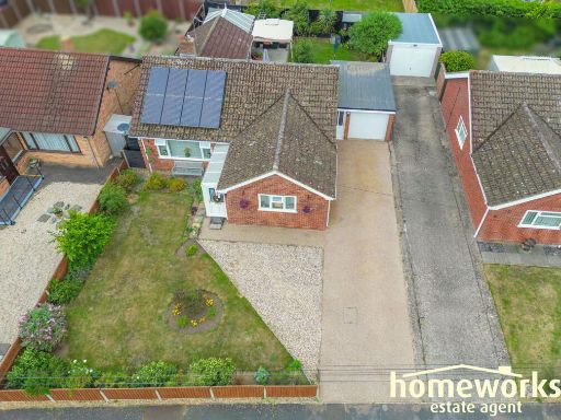 3 bedroom detached bungalow for sale in Middlemarch Road,Dereham,NR19 1EL, NR19 — £350,000 • 3 bed • 1 bath • 1009 ft²
 3 bedroom semi-detached house for sale in Shipdham Road, Dereham, NR19 1JR, NR19 — £260,000 • 3 bed • 1 bath • 1103 ft²
Meta
- {
"@context": "https://schema.org",
"@type": "Residence",
"name": "4 bedroom detached bungalow for sale in Stone Road, Toftwoo…",
"description": "",
"url": "https://propertypiper.co.uk/property/ba9c70ef-7c25-45e7-9daa-ec483b362c7d",
"image": "https://image-a.propertypiper.co.uk/291c1821-52a9-4170-8a73-3e43c9f06053-1024.jpeg",
"address": {
"@type": "PostalAddress",
"streetAddress": "22 STONE ROAD DEREHAM",
"postalCode": "NR19 1JS",
"addressLocality": "Breckland",
"addressRegion": "Mid Norfolk",
"addressCountry": "England"
},
"geo": {
"@type": "GeoCoordinates",
"latitude": 52.66382887776584,
"longitude": 0.9388238455768176
},
"numberOfRooms": 4,
"numberOfBathroomsTotal": 2,
"floorSize": {
"@type": "QuantitativeValue",
"value": 2006,
"unitCode": "FTK"
},
"offers": {
"@type": "Offer",
"price": 425000,
"priceCurrency": "GBP",
"availability": "https://schema.org/InStock"
},
"additionalProperty": [
{
"@type": "PropertyValue",
"name": "Feature",
"value": "1950s"
},
{
"@type": "PropertyValue",
"name": "Feature",
"value": "mid-century"
},
{
"@type": "PropertyValue",
"name": "Feature",
"value": "detached"
},
{
"@type": "PropertyValue",
"name": "Feature",
"value": "bungalow"
},
{
"@type": "PropertyValue",
"name": "Feature",
"value": "single-storey"
},
{
"@type": "PropertyValue",
"name": "Feature",
"value": "brick facade"
},
{
"@type": "PropertyValue",
"name": "Feature",
"value": "gable roof"
},
{
"@type": "PropertyValue",
"name": "Feature",
"value": "driveway"
},
{
"@type": "PropertyValue",
"name": "Feature",
"value": "front lawn"
},
{
"@type": "PropertyValue",
"name": "Feature",
"value": "well-maintained"
},
{
"@type": "PropertyValue",
"name": "Feature",
"value": "modern"
},
{
"@type": "PropertyValue",
"name": "Feature",
"value": "suburban"
},
{
"@type": "PropertyValue",
"name": "Feature",
"value": "residential"
},
{
"@type": "PropertyValue",
"name": "Feature",
"value": "modern living room"
},
{
"@type": "PropertyValue",
"name": "Feature",
"value": "french doors"
},
{
"@type": "PropertyValue",
"name": "Feature",
"value": "standard ceiling"
},
{
"@type": "PropertyValue",
"name": "Feature",
"value": "skylight"
},
{
"@type": "PropertyValue",
"name": "Feature",
"value": "natural light"
},
{
"@type": "PropertyValue",
"name": "Feature",
"value": "neutral decor"
}
]
}
High Res Floorplan Images
Compatible Floorplan Images
FloorplanImages Thumbnail