ST13 7HJ - Land for sale in Land off Basford View, Cheddleton, ST13
View on Property Piper
Land for sale in Land off Basford View, Cheddleton, ST13
Property Details
- Price: £50000
- Bedrooms: 1
- Bathrooms: 1
- Property Type: undefined
- Property SubType: undefined
Brochure Descriptions
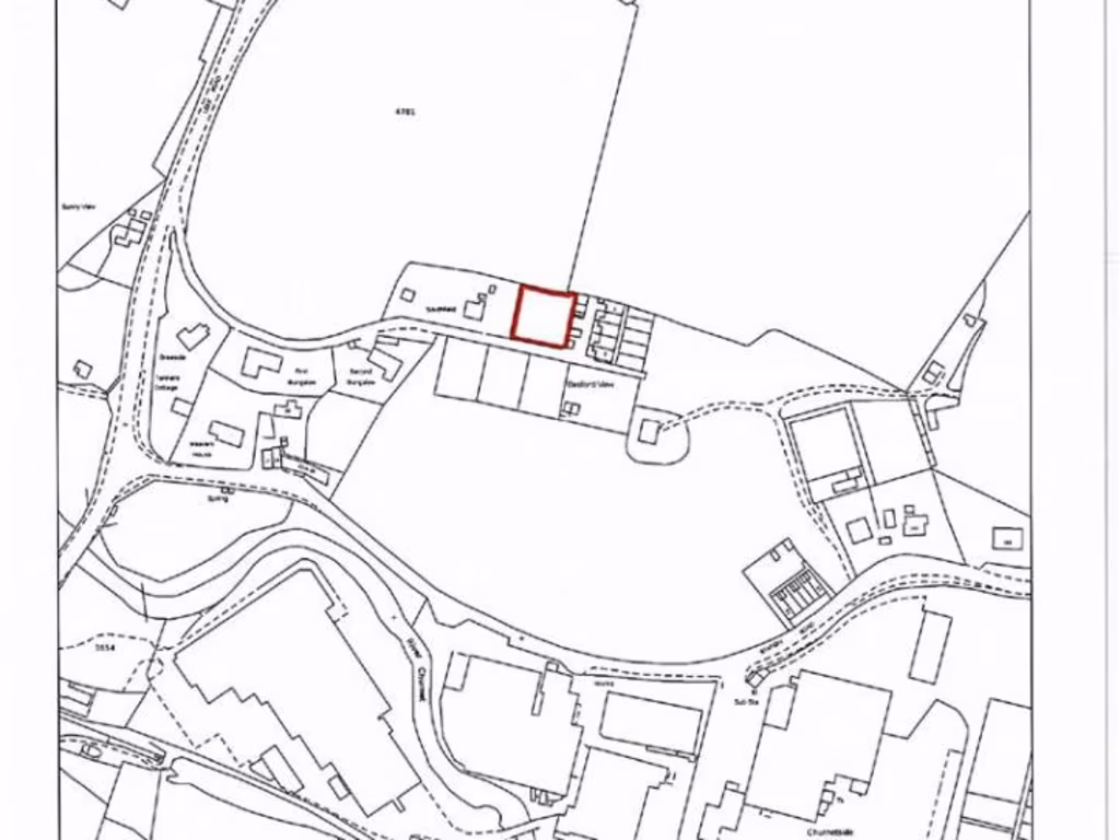
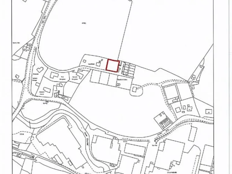
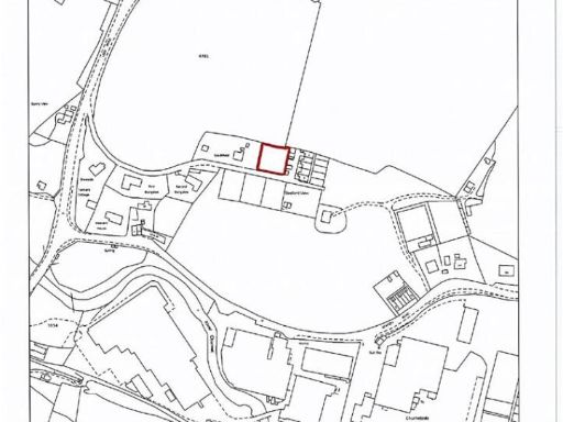
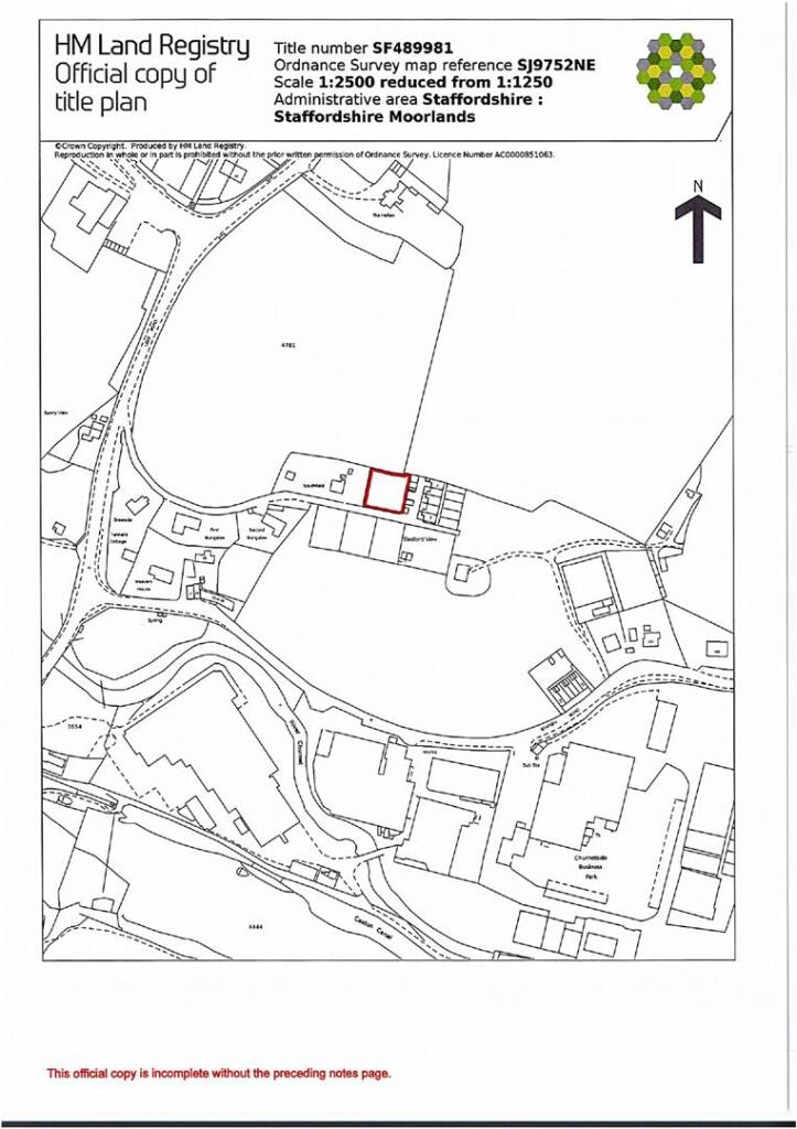
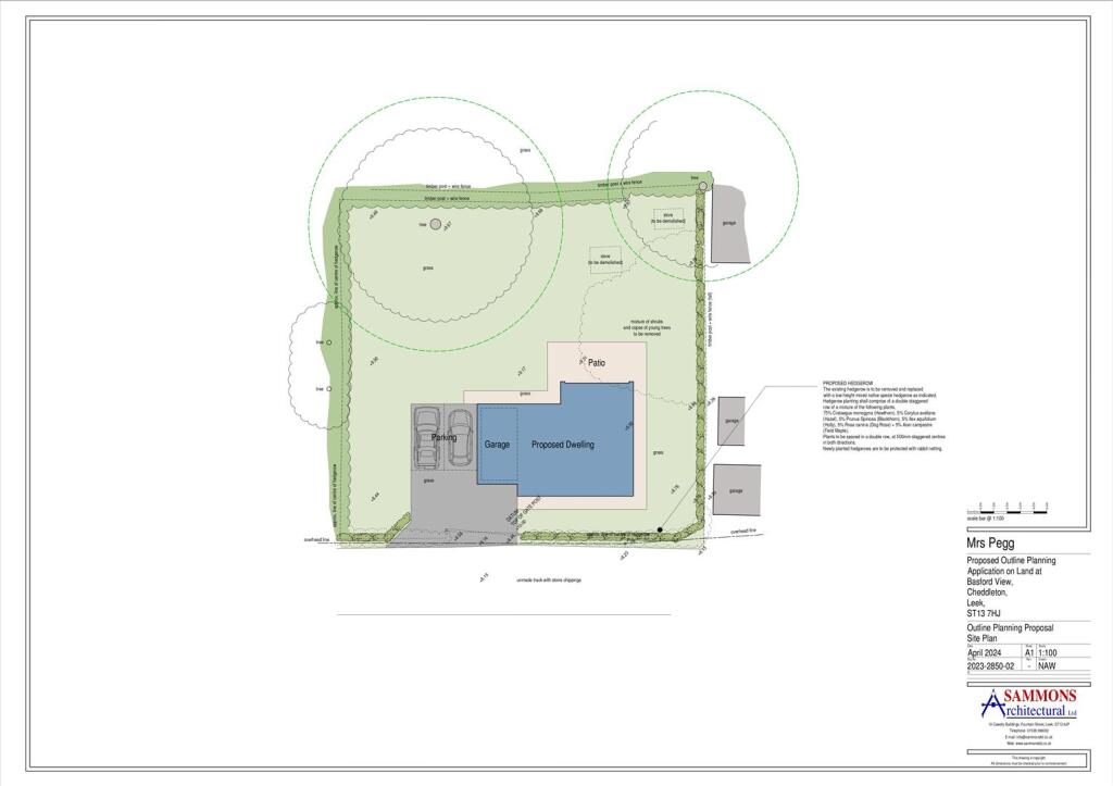
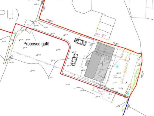
- Building plot with outline planning permission for one dwelling located on the north side of Basford View in Cheddleton (Leek), Staffordshire. The site extends to approximately 737 m² (around 0.18 acres) — a medium-sized residential plot suitable for a single detached dwelling. No specific views (sea/river/city) are indicated on the listing. The plot size suggests space for a modest garden and private outdoor amenity area. Guide price shown: £50,000 - £70,000.
Image Descriptions
- land_plot
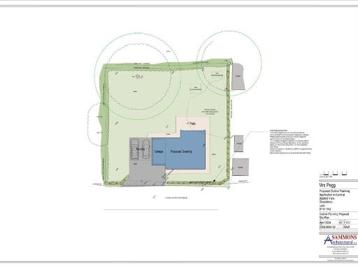
- property layout plan
Textual Property Features
Detected Visual Features
- land
- development opportunity
- plot
- vacant land
- investment
- potential
- residential
- commercial
- layout plan
- property plan
- site map
- construction blueprint
- building layout
- architectural drawing
Nearby Schools
- St Leonard's CofE (A) First School
- Blackshaw Moor CofE First School
- All Saints CofE First School
- Woodcroft Academy
- Werrington Primary School
- St Mary's Catholic Academy
- Westwood First School
- Leek First School
- Beresford Memorial CofE First School
- Churnet View Middle School
- St Werburgh's CE (A) Primary School
- St John's CofE Primary School
- Sporting Stars Academy
- St Edward's CofE Academy Cheddleton
- St Edward's Church of England Academy
- Westwood College
- Leek High School
- Evergreen
- Moorside High School
- Greenways Primary Academy
- Endon High School
- St Luke's CofE Academy Endon
- Endon Hall Primary School
- Horton St Michael's CofE First School
Nearest General Shops
- Id: 462198705
- Tags:
- Name: Gill Newsagent's
- Shop: newsagent
- TagsNormalized:
- Lat: 53.1030458
- Lon: -2.0290632
- FullGeoHash: gcqw1g47xmhy
- PartitionGeoHash: gcqw
- Images:
- FoodStandards: null
- Distance: 3525.6
,- Id: 459161864
- Tags:
- Bench: yes
- Highway: bus_stop
- Name: Chantelle
- Shelter: yes
- Shop: hairdresser
- TagsNormalized:
- bus
- bus stop
- hairdresser
- shop
- Lat: 53.0996867
- Lon: -2.0395954
- FullGeoHash: gcqw1ddb1gp3
- PartitionGeoHash: gcqw
- Images:
- FoodStandards: null
- Distance: 3107.7
,- Id: 173499547
- Tags:
- Addr:
- Brand: B&M Bargains
- Brand:wikidata: Q4836931
- Brand:wikipedia: en:B&M
- Building: retail
- Contact:
- Website: https://www.bmstores.co.uk/stores/leek-401
- Name: B&M Bargains
- Old_name: Focus
- Shop: variety_store
- TagsNormalized:
- b&m
- retail
- variety store
- shop
- Lat: 53.0994421
- Lon: -2.0333532
- FullGeoHash: gcqw1drqemmy
- PartitionGeoHash: gcqw
- Images:
- FoodStandards: null
- Distance: 3091.3
}
Nearest Grocery shops
- Id: 308538529
- Tags:
- Building: yes
- Name: Newsmarket
- Shop: convenience
- TagsNormalized:
- Lat: 53.1031102
- Lon: -2.029039
- FullGeoHash: gcqw1g4kpcnz
- PartitionGeoHash: gcqw
- Images:
- FoodStandards: null
- Distance: 3533
,- Id: 459161868
- Tags:
- Name: Wallbridge Post & Times
- Shop: convenience
- TagsNormalized:
- Lat: 53.0997102
- Lon: -2.0396634
- FullGeoHash: gcqw1ddb0rkt
- PartitionGeoHash: gcqw
- Images:
- FoodStandards: null
- Distance: 3110.5
,- Id: 173522252
- Tags:
- Addr:
- City: Leek
- Country: GB
- Housenumber: 163
- Postcode: ST13 7HN
- Street: Cheadle Road
- Brand: One Stop
- Brand:wikidata: Q65954217
- Building: retail
- Fhrs:
- Name: One Stop
- Shop: convenience
- TagsNormalized:
- one stop
- retail
- convenience
- shop
- Lat: 53.0632965
- Lon: -2.0425802
- FullGeoHash: gcqtcebsh7mv
- PartitionGeoHash: gcqt
- Images:
- FoodStandards:
- Id: 1259527
- FHRSID: 1259527
- LocalAuthorityBusinessID: 115882
- BusinessName: ONE STOP
- BusinessType: Retailers - other
- BusinessTypeID: 4613
- AddressLine1: 163 Cheadle Road
- AddressLine2: Cheddleton
- AddressLine3: Leek
- AddressLine4: null
- PostCode: ST13 7HN
- RatingValue: 5
- RatingKey: fhrs_5_en-GB
- RatingDate: 2019-07-09
- LocalAuthorityCode: 293
- LocalAuthorityName: Staffordshire Moorlands
- LocalAuthorityWebSite: http://www.staffsmoorlands.gov.uk
- LocalAuthorityEmailAddress: Envhealth@highpeak.gov.uk
- Scores:
- Hygiene: 0
- Structural: 0
- ConfidenceInManagement: 0
- NewRatingPending: false
- Geocode:
- Longitude: -2.04264910000000
- Latitude: 53.06329250000000
- Distance: 997.1
}
Nearest Supermarkets
- Id: 173499615
- Tags:
- Addr:
- Country: GB
- Postcode: ST13 6AH
- Street: Portland Street North
- Brand: Lidl
- Brand:wikidata: Q151954
- Brand:wikipedia: en:Lidl
- Building: retail
- Fhrs:
- Name: Lidl
- Old_name: Co-op then Waitrose
- Shop: supermarket
- TagsNormalized:
- lidl
- retail
- supermarket
- shop
- Lat: 53.1079337
- Lon: -2.0187397
- FullGeoHash: gcqw4h1bpuqs
- PartitionGeoHash: gcqw
- Images:
- FoodStandards:
- Id: 1259573
- FHRSID: 1259573
- LocalAuthorityBusinessID: 116696
- BusinessName: LIDL
- BusinessType: Retailers - supermarkets/hypermarkets
- BusinessTypeID: 7840
- AddressLine1: Portland Street North
- AddressLine2: Leek
- AddressLine3: Staffordshire
- AddressLine4: null
- PostCode: ST13 6AH
- RatingValue: 5
- RatingKey: fhrs_5_en-GB
- RatingDate: 2018-11-26
- LocalAuthorityCode: 293
- LocalAuthorityName: Staffordshire Moorlands
- LocalAuthorityWebSite: http://www.staffsmoorlands.gov.uk
- LocalAuthorityEmailAddress: Envhealth@highpeak.gov.uk
- Scores:
- Hygiene: 0
- Structural: 0
- ConfidenceInManagement: 0
- NewRatingPending: false
- Geocode:
- Longitude: -2.01757097244263
- Latitude: 53.10784912109380
- Distance: 4215.9
,- Id: 173499915
- Tags:
- Brand: ALDI
- Brand:wikidata: Q41171672
- Brand:wikipedia: en:Aldi
- Building: retail
- Contact:
- Website: https://stores.aldi.co.uk/leek/haywood-street
- Name: Aldi
- Shop: supermarket
- TagsNormalized:
- aldi
- retail
- supermarket
- shop
- Lat: 53.1050619
- Lon: -2.0227524
- FullGeoHash: gcqw1grp6mn3
- PartitionGeoHash: gcqw
- Images:
- FoodStandards: null
- Distance: 3834.2
,- Id: 93940321
- Tags:
- Brand: Morrisons
- Brand:wikidata: Q922344
- Brand:wikipedia: en:Morrisons
- Building: retail
- Contact:
- Website: https://my.morrisons.com/storefinder/251
- Name: Morrisons
- Shop: supermarket
- Source: Bing
- Toilets: yes
- Toilets:wheelchair: yes
- Wheelchair: yes
- TagsNormalized:
- morrisons
- retail
- supermarket
- shop
- Lat: 53.09968
- Lon: -2.0319506
- FullGeoHash: gcqw1f82h1gc
- PartitionGeoHash: gcqw
- Images:
- FoodStandards: null
- Distance: 3127.6
}
Nearest Religious buildings
- Id: 433123413
- Tags:
- Amenity: place_of_worship
- Building: church
- Denomination: anglican
- Name: Longsdon St. Chad
- Religion: christian
- Wikidata: Q17531113
- TagsNormalized:
- place of worship
- church
- anglican
- christian
- Lat: 53.088724
- Lon: -2.0625964
- FullGeoHash: gcqw10d04p2w
- PartitionGeoHash: gcqw
- Images:
- FoodStandards: null
- Distance: 2516.2
,- Id: 322510293
- Tags:
- Amenity: place_of_worship
- Building: church
- Religion: christian
- TagsNormalized:
- place of worship
- church
- christian
- Lat: 53.0799828
- Lon: -2.0400086
- FullGeoHash: gcqtcwft23gq
- PartitionGeoHash: gcqt
- Images:
- FoodStandards: null
- Distance: 927.4
,- Id: 433372488
- Tags:
- Amenity: place_of_worship
- Building: church
- Denomination: anglican
- Name: St. Edward the Confessor
- Note: Spelling error corrected
- Religion: christian
- Source: Bing
- Wikidata: Q17531498
- TagsNormalized:
- place of worship
- church
- anglican
- christian
- Lat: 53.0689654
- Lon: -2.0448372
- FullGeoHash: gcqtckyvpu4v
- PartitionGeoHash: gcqt
- Images:
- FoodStandards: null
- Distance: 571.5
}
Nearest Medical buildings
- Id: 1843022388
- Tags:
- Amenity: pharmacy
- Brand: Superdrug
- Brand:wikidata: Q7643261
- Brand:wikipedia: en:Superdrug
- Healthcare: pharmacy
- Name: Superdrug
- TagsNormalized:
- pharmacy
- superdrug
- health
- healthcare
- Lat: 53.1056102
- Lon: -2.0226891
- FullGeoHash: gcqw1gx4egm8
- PartitionGeoHash: gcqw
- Images:
- FoodStandards: null
- Distance: 3894.2
,- Id: 10605980278
- Tags:
- Amenity: dentist
- Healthcare: dentist
- Name: St. Edward Street Dental Practice
- TagsNormalized:
- dentist
- health
- healthcare
- dental
- Lat: 53.1050787
- Lon: -2.0261788
- FullGeoHash: gcqw1gkxd85t
- PartitionGeoHash: gcqw
- Images:
- FoodStandards: null
- Distance: 3783.1
,- Id: 443727534
- Tags:
- Amenity: clinic
- Healthcare: clinic
- Name: Edith Shaw Unit
- Note: part of John Munroe Independent Hospital
- TagsNormalized:
- clinic
- health
- healthcare
- unit
- Lat: 53.1026419
- Lon: -2.0275417
- FullGeoHash: gcqw1g596cgm
- PartitionGeoHash: gcqw
- Images:
- FoodStandards: null
- Distance: 3499.5
,- Id: 433372495
- Tags:
- Amenity: clinic
- Building: yes
- Healthcare: clinic
- Name: Ashcombe Centre
- Source: Bing
- TagsNormalized:
- Lat: 53.0734305
- Lon: -2.0410823
- FullGeoHash: gcqtct9xpkd8
- PartitionGeoHash: gcqt
- Images:
- FoodStandards: null
- Distance: 294.4
}
Nearest Leisure Facilities
- Id: 433372475
- Tags:
- Leisure: pitch
- Source: Bing
- Sport: soccer
- TagsNormalized:
- Lat: 53.0673047
- Lon: -2.0471946
- FullGeoHash: gcqtckt72yt5
- PartitionGeoHash: gcqt
- Images:
- FoodStandards: null
- Distance: 807.1
,- Id: 433372478
- Tags:
- Leisure: pitch
- Source: Bing
- Sport: tennis
- TagsNormalized:
- Lat: 53.0660551
- Lon: -2.0403673
- FullGeoHash: gcqtcs6hpvxu
- PartitionGeoHash: gcqt
- Images:
- FoodStandards: null
- Distance: 659.9
,- Id: 335336830
- Tags:
- Leisure: pitch
- Sport: bowls
- TagsNormalized:
- Lat: 53.0660225
- Lon: -2.0397351
- FullGeoHash: gcqtcs6eyxx6
- PartitionGeoHash: gcqt
- Images:
- FoodStandards: null
- Distance: 653.1
,- Id: 335336831
- Tags:
- Leisure: pitch
- Sport: soccer
- TagsNormalized:
- Lat: 53.0662243
- Lon: -2.0381316
- FullGeoHash: gcqtcs7vhj4y
- PartitionGeoHash: gcqt
- Images:
- FoodStandards: null
- Distance: 616.6
,- Id: 433372480
- Tags:
- Leisure: playground
- Source: Bing
- TagsNormalized:
- Lat: 53.0665314
- Lon: -2.0402243
- FullGeoHash: gcqtcs6qgq6q
- PartitionGeoHash: gcqt
- Images:
- FoodStandards: null
- Distance: 606.4
}
Nearest Tourist attractions
- Id: 3670855624
- Tags:
- TagsNormalized:
- Lat: 53.0757211
- Lon: -2.0594194
- FullGeoHash: gcqtcnhkkp98
- PartitionGeoHash: gcqt
- Images:
- FoodStandards: null
- Distance: 1518.8
,- Id: 335336834
- Tags:
- TagsNormalized:
- Lat: 53.0686192
- Lon: -2.0288178
- FullGeoHash: gcqtcufej5eu
- PartitionGeoHash: gcqt
- Images:
- FoodStandards: null
- Distance: 686.4
,- Id: 1199214375
- Tags:
- Name: Cheddleton Flint Mill
- Tourism: museum
- Wikidata: Q5089205
- Wikipedia: en:Cheddleton Flint Mill
- TagsNormalized:
- Lat: 53.0707741
- Lon: -2.0430162
- FullGeoHash: gcqtct0rdm2d
- PartitionGeoHash: gcqt
- Images:
- FoodStandards: null
- Distance: 374.3
}
Nearest Train stations
- Id: 58978505
- Tags:
- Name: Blythe Bridge
- Naptan:
- Network: National Rail
- Public_transport: station
- Railway: station
- Ref:
- Source: GPS waypoint
- Wikidata: Q2525068
- Wikipedia: en:Blythe Bridge railway station
- TagsNormalized:
- Lat: 52.9678303
- Lon: -2.066925
- FullGeoHash: gcqt2fqzvpjp
- PartitionGeoHash: gcqt
- Images:
- FoodStandards: null
- Distance: 11721.3
,- Id: 58978526
- Tags:
- Internet_access: no
- Name: Longton
- Naptan:
- Network: National Rail
- Public_transport: station
- Railway: station
- Ref:
- Source: NPE
- Wikidata: Q2096431
- Wikipedia: en:Longton railway station
- TagsNormalized:
- Lat: 52.9900417
- Lon: -2.1372966
- FullGeoHash: gcqmrqe9m7sp
- PartitionGeoHash: gcqm
- Images:
- FoodStandards: null
- Distance: 11267.9
,- Id: 8361780629
- Tags:
- Name: Foxfield Colliery
- Public_transport: station
- Railway: station
- Usage: tourism
- TagsNormalized:
- Lat: 52.9984067
- Lon: -2.0369415
- FullGeoHash: gcqt98hdpg46
- PartitionGeoHash: gcqt
- Images:
- FoodStandards: null
- Distance: 8156.9
,- Id: 671328140
- Tags:
- Name: Kingsley & Froghall
- Naptan:
- Operator: Churnet Valley Railway
- Platforms: 2
- Public_transport: station
- Railway: station
- Tourism: heritage_railway
- Usage: tourism
- TagsNormalized:
- Lat: 53.0215468
- Lon: -1.9645057
- FullGeoHash: gcqtek32zswq
- PartitionGeoHash: gcqt
- Images:
- FoodStandards: null
- Distance: 7422.3
,- Id: 478751924
- Tags:
- Listed_status: Grade II
- Name: Cheddleton
- Naptan:
- Public_transport: station
- Railway: station
- Tourism: heritage_railway
- Usage: tourism
- Wikidata: Q5089206
- TagsNormalized:
- Lat: 53.0654183
- Lon: -2.0272962
- FullGeoHash: gcqtcu7b2wfq
- PartitionGeoHash: gcqt
- Images:
- FoodStandards: null
- Distance: 988.5
}
Nearest Hotels
- Id: 299206794
- Tags:
- Addr:
- Postcode: ST13 5DG
- Street: Ashbourne Road
- Brand: Premier Inn
- Brand:wikidata: Q2108626
- Brand:wikipedia: en:Premier Inn
- Building: hotel
- Fhrs:
- Internet_access: wlan
- Internet_access:fee: customers
- Internet_access:operator: Virgin Media
- Internet_access:ssid: Premier Inn Free Wi-Fi
- Name: Premier Inn
- Source: OS OpenData StreetView
- Source:addr: FHRS Open Data
- Tourism: hotel
- TagsNormalized:
- Lat: 53.1053928
- Lon: -2.0200753
- FullGeoHash: gcqw45912fdx
- PartitionGeoHash: gcqw
- Images:
- FoodStandards: null
- Distance: 3919.6
,- Id: 443727535
- Tags:
- Addr:
- Housenumber: 21
- Postcode: ST13 5NW
- Street: King Street
- Fhrs:
- Name: Peak Weavers Hotel
- Source:
- Tourism: hotel
- TagsNormalized:
- Lat: 53.1033814
- Lon: -2.0258057
- FullGeoHash: gcqw1ghve7cb
- PartitionGeoHash: gcqw
- Images:
- FoodStandards: null
- Distance: 3603.9
,- Id: 443727536
- Tags:
- Name: The Green Man Motel
- Tourism: hotel
- TagsNormalized:
- Lat: 53.1032178
- Lon: -2.0250381
- FullGeoHash: gcqw1gjktjq1
- PartitionGeoHash: gcqw
- Images:
- FoodStandards: null
- Distance: 3597.8
}
Tags
- land
- development opportunity
- plot
- vacant land
- investment
- potential
- residential
- commercial
- layout plan
- property plan
- site map
- construction blueprint
- building layout
- architectural drawing
Local Market Stats
- Average Price/sqft: £206
- Avg Income: £40000
- Rental Yield: 3.4%
- Social Housing: 3%
- Planning Success Rate: 83%
AirBnB Data
- 1km average: £61/night
- Listings in 1km: 1
Similar Properties
 Land for sale in Church Lane, Stoke on Trent, ST10 — £85,000 • 1 bed • 1 bath • 4356 ft²
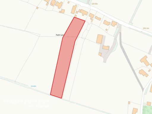 Land for sale in 34 Station Road, Stoke-on-Trent, ST7 — £20,000 • 1 bed • 1 bath
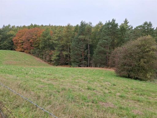 Land for sale in Land at Stoneydale, Oakamoor, Stoke-On-Trent, ST10 — £30,000 • 1 bed • 1 bath
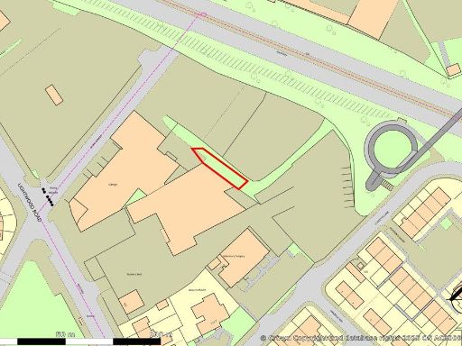 Land for sale in Land Between Lloyd Sreet And Locketts Lane, Longton, Stoke-On-Trent, Staffordshire, ST3 4JQ, ST3 — POA • 1 bed • 1 bath • 1975 ft²
 Land for sale in 0.63 Acre Former Nursery Site with Planning Consent - Gravel Bank Farm, Caverswall Common, Caverswall, Staffordshire, ST11 — £500,000 • 1 bed • 1 bath
 Land for sale in Copplestone Grove, Stoke on Trent, ST3 — £15,000 • 1 bed • 1 bath
Meta
- {
"@context": "https://schema.org",
"@type": "Residence",
"name": "Land for sale in Land off Basford View, Cheddleton, ST13",
"description": "",
"url": "https://propertypiper.co.uk/property/b91453bf-5e04-4088-bd6c-1088e0f4448e",
"image": "https://image-a.propertypiper.co.uk/02ed455d-e56c-4989-85b6-58bbd01cd0da-1024.jpeg",
"address": {
"@type": "PostalAddress",
"streetAddress": "1 BASFORD VIEW CHEDDLETON LEEK",
"postalCode": "ST13 7HJ",
"addressLocality": "Staffordshire Moorlands",
"addressRegion": "Staffordshire Moorlands",
"addressCountry": "England"
},
"geo": {
"@type": "GeoCoordinates",
"latitude": 53.07176235285632,
"longitude": -2.037660129607776
},
"numberOfRooms": 1,
"numberOfBathroomsTotal": 1,
"floorSize": {
"@type": "QuantitativeValue",
"value": 7841,
"unitCode": "FTK"
},
"offers": {
"@type": "Offer",
"price": 50000,
"priceCurrency": "GBP",
"availability": "https://schema.org/InStock"
},
"additionalProperty": [
{
"@type": "PropertyValue",
"name": "Feature",
"value": "land"
},
{
"@type": "PropertyValue",
"name": "Feature",
"value": "development opportunity"
},
{
"@type": "PropertyValue",
"name": "Feature",
"value": "plot"
},
{
"@type": "PropertyValue",
"name": "Feature",
"value": "vacant land"
},
{
"@type": "PropertyValue",
"name": "Feature",
"value": "investment"
},
{
"@type": "PropertyValue",
"name": "Feature",
"value": "potential"
},
{
"@type": "PropertyValue",
"name": "Feature",
"value": "residential"
},
{
"@type": "PropertyValue",
"name": "Feature",
"value": "commercial"
},
{
"@type": "PropertyValue",
"name": "Feature",
"value": "layout plan"
},
{
"@type": "PropertyValue",
"name": "Feature",
"value": "property plan"
},
{
"@type": "PropertyValue",
"name": "Feature",
"value": "site map"
},
{
"@type": "PropertyValue",
"name": "Feature",
"value": "construction blueprint"
},
{
"@type": "PropertyValue",
"name": "Feature",
"value": "building layout"
},
{
"@type": "PropertyValue",
"name": "Feature",
"value": "architectural drawing"
}
]
}