PL4 6AR - Commercial property for sale in Office 8 R.E.I., 15 Apsley…
View on Property Piper
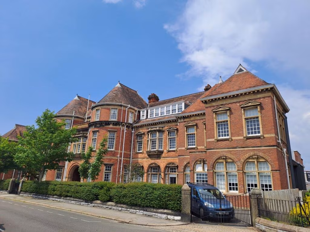
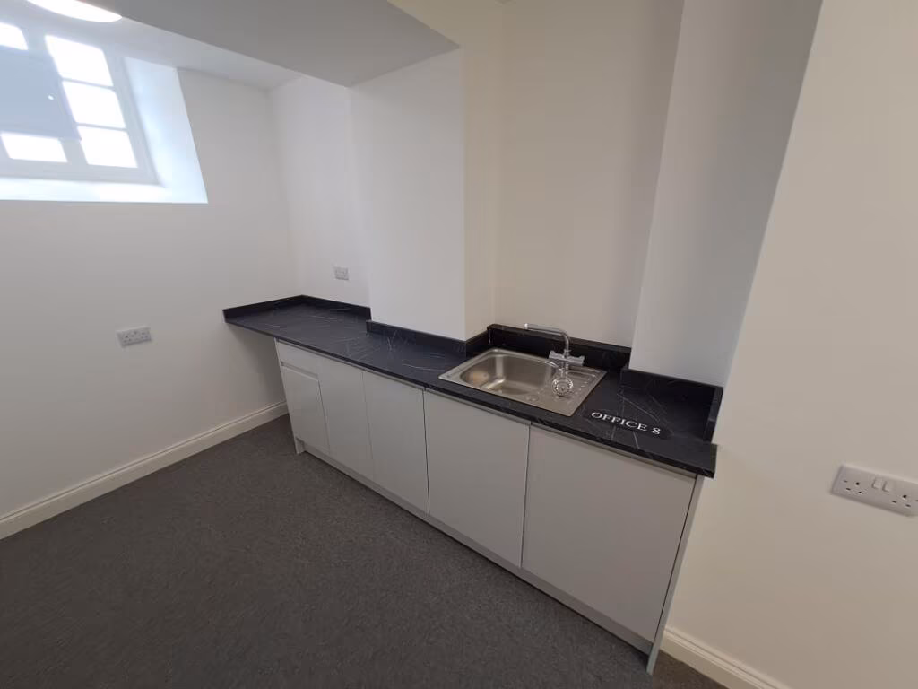
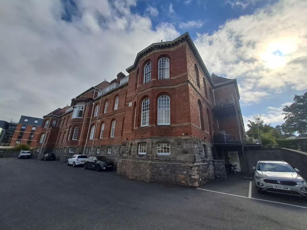
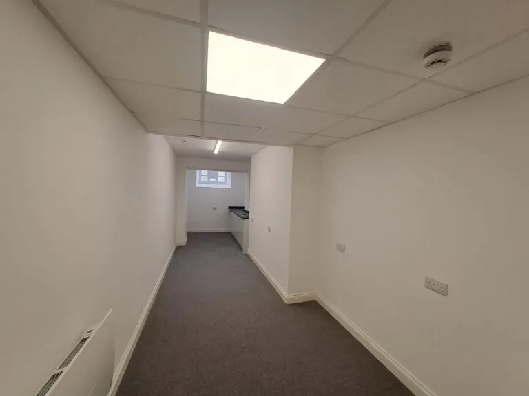
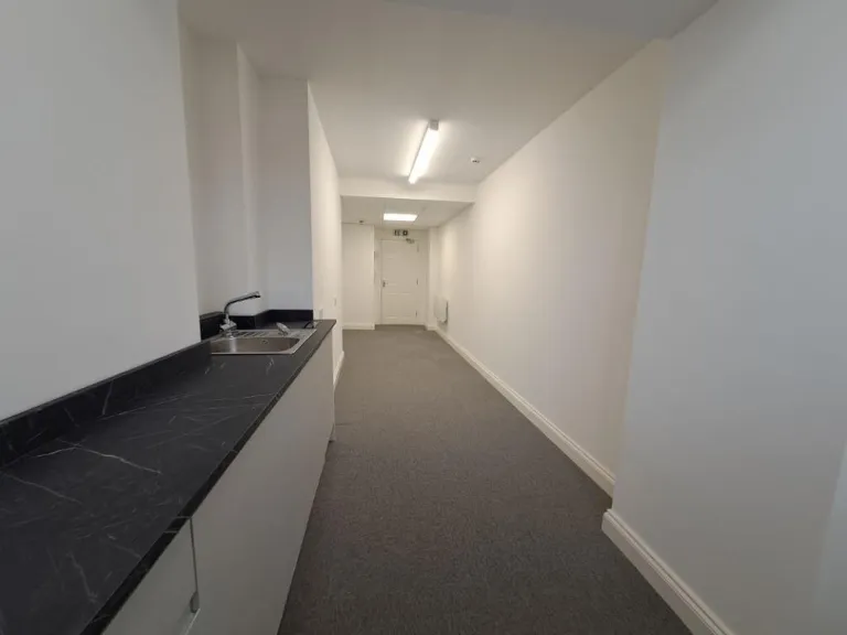
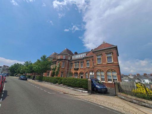
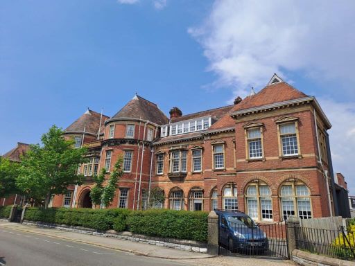
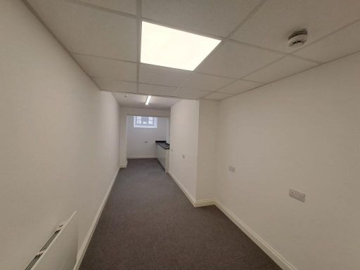
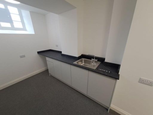
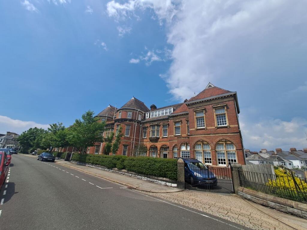
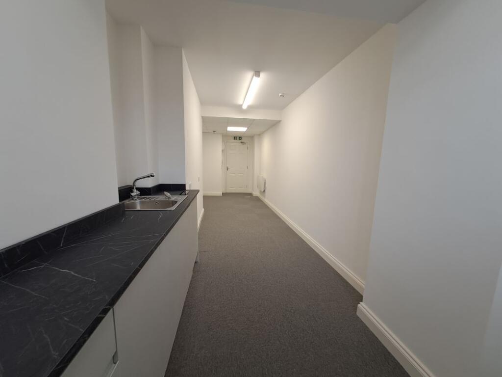
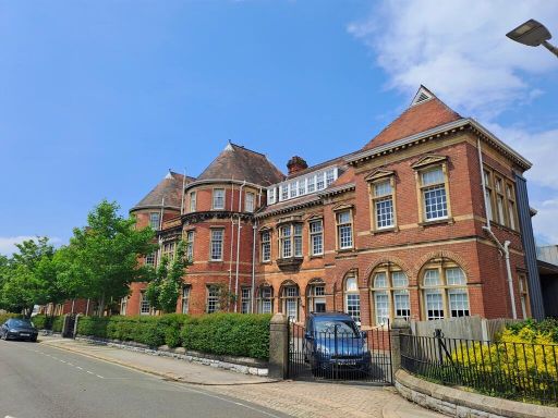
Commercial property for sale in Office 8 R.E.I., 15 Apsley Road, Plymouth, Devon, PL4 6AR, PL4
Property Details
- Price: £27000
- Bedrooms: 1
- Bathrooms: 1
- Property Type: undefined
- Property SubType: undefined
Image Descriptions
- residential building Victorian
- period building Victorian
Textual Property Features
Detected Visual Features
- Victorian
- red brick
- arched windows
- three-story
- residential
- terraced house
- traditional architecture
- historic
- period property
- high ceilings
- mansard roof
- gated access
- street-facing
EPC Details
- Single glazed
- Average thermal transmittance 1.31 W/m-¦K
- Boiler and underfloor heating, mains gas
- Low energy lighting in 75% of fixed outlets
- (other premises below)
Nearby Schools
- Millbay Academy
- High Street Primary Academy
- Pilgrim Primary Academy
- Hyde Park Infants' School
- King's School
- Compton CofE Primary School
- Pennycross Primary School
- Manadon Vale Primary School
- The Cathedral School of St Mary
- Salisbury Road Primary School
- Plymouth High School for Girls
- Lipson Vale Primary School
- Plymouth College
- Hyde Park Junior School
- Montpelier Primary School
- St Boniface's RC College
- St Andrew's Cof E VA Primary School
- Prince Rock Primary School
- Holy Cross Catholic Primary School
- Mount Street Primary School
- Fletewood School at Derry Villas
- Scott Medical and Healthcare College
- Devonport High School for Girls
- St Peter's CofE Primary School
- Devonport High School for Boys
- Stuart Road Primary School
- Stoke Damerel Community College
Nearest Bars And Restaurants
- Id: 919680706
- Tags:
- Amenity: pub
- Building: yes
- Name: The Junction
- Wikidata: Q79838181
- TagsNormalized:
- Lat: 50.3803213
- Lon: -4.1337965
- FullGeoHash: gbvn9gmyes9f
- PartitionGeoHash: gbvn
- Images:
- FoodStandards: null
- Distance: 372.1
,- Id: 952694980
- Tags:
- Amenity: fast_food
- Building: yes
- Cuisine: kebab
- Name: Food4U
- TagsNormalized:
- Lat: 50.3781134
- Lon: -4.1355479
- FullGeoHash: gbvn9gh9f9pb
- PartitionGeoHash: gbvn
- Images:
- FoodStandards: null
- Distance: 369.4
,- Id: 8268168495
- Tags:
- Amenity: fast_food
- Cuisine: chinese
- Name: New Dragon House
- TagsNormalized:
- Lat: 50.3784108
- Lon: -4.1406977
- FullGeoHash: gbvn9g0gdb2n
- PartitionGeoHash: gbvn
- Images:
- FoodStandards: null
- Distance: 269.2
,- Id: 2613501724
- Tags:
- Amenity: cafe
- Name: World Peace Cafe
- TagsNormalized:
- Lat: 50.379089
- Lon: -4.138829
- FullGeoHash: gbvn9g4pqqc7
- PartitionGeoHash: gbvn
- Images:
- FoodStandards: null
- Distance: 166.9
,- Id: 890225367
- Tags:
- Amenity: cafe
- Building: yes
- Cuisine: sandwich;breakfast
- Internet_access: yes
- Name: Wilphey Sandwich Bar
- Opening_hours: Mo-Fr 08:00-15:00
- Outdoor_seating: yes
- Website: http://www.wilphys.co.uk/
- TagsNormalized:
- Lat: 50.3808085
- Lon: -4.1397372
- FullGeoHash: gbvn9g993pkh
- PartitionGeoHash: gbvn
- Images:
- FoodStandards: null
- Distance: 56.1
}
Nearest General Shops
- Id: 876208169
- Tags:
- Building: yes
- Name: Mutley Plain Autocare
- Shop: car_repair
- TagsNormalized:
- Lat: 50.3819721
- Lon: -4.134398
- FullGeoHash: gbvn9gv2m836
- PartitionGeoHash: gbvn
- Images:
- FoodStandards: null
- Distance: 362.7
,- Id: 872358297
- Tags:
- Addr:
- City: Plymouth
- Housenumber: 70,60B
- Street: Ridge Park Avenue
- Building: house
- Name: Chakra Health and Beauty
- Roof:
- Material: roof_tiles
- Shape: hipped
- Shop: hairdresser
- TagsNormalized:
- beauty
- health
- hairdresser
- shop
- Lat: 50.3816891
- Lon: -4.1435651
- FullGeoHash: gbvn9ewwxgtc
- PartitionGeoHash: gbvn
- Images:
- FoodStandards: null
- Distance: 344.3
,- Id: 2613813490
- Tags:
- Name: Homebrew Shop
- Shop: beverages
- TagsNormalized:
- Lat: 50.3803464
- Lon: -4.141854
- FullGeoHash: gbvn9eryzc3b
- PartitionGeoHash: gbvn
- Images:
- FoodStandards: null
- Distance: 202.1
}
Nearest Grocery shops
- Id: 915915698
- Tags:
- Building: yes
- Name: Mutley Bazaar
- Shop: convenience
- TagsNormalized:
- Lat: 50.3811947
- Lon: -4.1332622
- FullGeoHash: gbvn9gw78p2k
- PartitionGeoHash: gbvn
- Images:
- FoodStandards: null
- Distance: 414.4
,- Id: 915915702
- Tags:
- Building: retail
- Mapillary: 718074086039444
- Name: Pickle Deli & Market
- Shop: convenience
- Survey:
- TagsNormalized:
- retail
- deli
- convenience
- shop
- Lat: 50.3809785
- Lon: -4.1332752
- FullGeoHash: gbvn9gw4rxne
- PartitionGeoHash: gbvn
- Images:
- FoodStandards: null
- Distance: 410.3
,- Id: 874085367
- Tags:
- Addr:
- City: Plymouth
- Housenumber: 32
- Postcode: PL4 6PG
- Street: Green Park Avenue
- Brand: Spar
- Brand:wikidata: Q610492
- Brand:wikipedia: en:Spar (retailer)
- Building: retail
- Name: Spar
- Opening_hours: Mo-Sa 06:00-22:00; Su 07:00-22:00
- Payment:
- Cash: yes
- Credit_cards: yes
- Debit_cards: yes
- Mastercard: yes
- Visa: yes
- Roof:
- Material: roof_tiles
- Shape: side_hipped
- Shop: convenience
- Wheelchair: no
- TagsNormalized:
- spar
- retail
- convenience
- shop
- Lat: 50.3801557
- Lon: -4.1419512
- FullGeoHash: gbvn9ervtt9q
- PartitionGeoHash: gbvn
- Images:
- FoodStandards: null
- Distance: 212.7
}
Nearest Supermarkets
- Id: 640840724
- Tags:
- Brand: Sainsbury's
- Brand:wikidata: Q152096
- Brand:wikipedia: en:Sainsbury's
- Building:
- Level: 1
- Name: Sainsbury's
- Opening_hours: Mo-Sa 07:00-20:00, Su 10:30-16:30
- Shop: supermarket
- TagsNormalized:
- sainsburys
- supermarket
- shop
- Lat: 50.3737111
- Lon: -4.1442319
- FullGeoHash: gbvn9dq20kke
- PartitionGeoHash: gbvn
- Images:
- FoodStandards: null
- Distance: 848.8
,- Id: 406673058
- Tags:
- Brand: ALDI
- Brand:wikidata: Q41171672
- Brand:wikipedia: en:Aldi
- Building: retail
- Building:levels: 1
- Contact:
- Website: https://stores.aldi.co.uk/plymouth/greenbank-road
- Name: ALDI
- Opening_hours: Mo-Sa 08:00-22:00; Su 10:00-16:00
- Shop: supermarket
- TagsNormalized:
- aldi
- retail
- supermarket
- shop
- Lat: 50.3794956
- Lon: -4.1311913
- FullGeoHash: gbvn9grcb68m
- PartitionGeoHash: gbvn
- Images:
- FoodStandards: null
- Distance: 568.7
,- Id: 912865793
- Tags:
- Brand: Co-op Food
- Brand:wikidata: Q3277439
- Brand:wikipedia: en:Co-op Food
- Building: yes
- Name: Co-op Food
- Opening_hours: Mo-Sa 06:00-23:00; Su 10:00-16:00
- Shop: supermarket
- TagsNormalized:
- co-op
- co-op food
- food
- supermarket
- shop
- Lat: 50.3827574
- Lon: -4.1345717
- FullGeoHash: gbvn9gvkc6xy
- PartitionGeoHash: gbvn
- Images:
- FoodStandards: null
- Distance: 397.7
}
Nearest Religious buildings
- Id: 508749297
- Tags:
- Amenity: place_of_worship
- Building: yes
- Denomination: baptist
- Listed_status: Grade II*
- Name: Mutley Baptist Church
- Religion: christian
- Wikidata: Q17554465
- Wikipedia: en:Mutley Baptist Church
- TagsNormalized:
- place of worship
- baptist
- church
- christian
- Lat: 50.3809435
- Lon: -4.1339496
- FullGeoHash: gbvn9gtdrbxf
- PartitionGeoHash: gbvn
- Images:
- FoodStandards: null
- Distance: 362.3
,- Id: 2613571829
- Tags:
- Amenity: place_of_worship
- Name: Ashoka Kadampa Buddhist Centre
- Religion: buddhist
- Wheelchair: limited
- TagsNormalized:
- place of worship
- buddhist
- buddhist temple
- temple
- Lat: 50.379089
- Lon: -4.138818
- FullGeoHash: gbvn9g4pqwce
- PartitionGeoHash: gbvn
- Images:
- FoodStandards: null
- Distance: 167
,- Id: 923156652
- Tags:
- Amenity: place_of_worship
- Building: religious
- Mapillary: 161771226187991
- Name: The Overcomers Christian Fellowship International
- Religion: christian
- Survey:
- TagsNormalized:
- place of worship
- religious
- christian
- church
- Lat: 50.3799543
- Lon: -4.1385498
- FullGeoHash: gbvn9g6ksb1t
- PartitionGeoHash: gbvn
- Images:
- FoodStandards: null
- Distance: 77.9
}
Nearest Medical buildings
- Id: 10576536158
- Tags:
- Amenity: pharmacy
- Brand: Boots
- Brand:wikidata: Q6123139
- Healthcare: pharmacy
- Name: Boots
- TagsNormalized:
- pharmacy
- boots
- health
- healthcare
- Lat: 50.3771935
- Lon: -4.1383697
- FullGeoHash: gbvn9ffs2vxb
- PartitionGeoHash: gbvn
- Images:
- FoodStandards: null
- Distance: 380
,- Id: 15351464
- Tags:
- Addr:
- Housename: Ensleigh House
- Street: Endsleigh Place
- Amenity: doctors
- Building: yes;university
- Healthcare: doctor
- Name: University Wellbeing & Medical Centre
- Type: multipolygon
- Website: https://plymouthstudenthealth.com/
- TagsNormalized:
- doctor
- doctors
- university
- health
- healthcare
- Lat: 50.3773181
- Lon: -4.1384481
- FullGeoHash: gbvn9ffmphtr
- PartitionGeoHash: gbvn
- Images:
- FoodStandards: null
- Distance: 365.6
,- Id: 930451727
- Tags:
- Addr:
- City: Plymouth
- Housenumber: 31
- Postcode: PL4 6AY
- Street: North Road East
- Amenity: dentist
- Building: house
- Healthcare: dentist
- Listed_status: Grade II
- Name: Quay Dentalcare
- Roof:
- Material: roof_tiles
- Orientation: across
- Shape: gabled
- TagsNormalized:
- dentist
- health
- healthcare
- dental
- Lat: 50.3776115
- Lon: -4.1372536
- FullGeoHash: gbvn9fgqg52n
- PartitionGeoHash: gbvn
- Images:
- FoodStandards: null
- Distance: 353.8
,- Id: 741033583
- Tags:
- Addr:
- City: Plymouth
- Street: Ford Park Road
- Amenity: doctors
- Building: yes
- Healthcare: doctor
- Name: Park View Surgery
- Roof:
- TagsNormalized:
- doctor
- doctors
- health
- healthcare
- surgery
- Lat: 50.3828525
- Lon: -4.1392028
- FullGeoHash: gbvn9gcvms6t
- PartitionGeoHash: gbvn
- Images:
- FoodStandards: null
- Distance: 252.4
}
Nearest Leisure Facilities
- Id: 722240119
- Tags:
- Leisure: pitch
- Sport: multi
- TagsNormalized:
- Lat: 50.3842471
- Lon: -4.1372728
- FullGeoHash: gbvn9u5md83v
- PartitionGeoHash: gbvn
- Images:
- FoodStandards: null
- Distance: 425.8
,- Id: 915915736
- Tags:
- Building: yes
- Leisure: fitness_centre
- Name: Yoga Blend
- Sport: yoga
- TagsNormalized:
- fitness
- fitness centre
- leisure
- yoga
- sports
- Lat: 50.3822819
- Lon: -4.1342343
- FullGeoHash: gbvn9gvd1656
- PartitionGeoHash: gbvn
- Images:
- FoodStandards: null
- Distance: 388.8
,- Id: 1134498499
- Tags:
- Access: private
- Garden:
- Leisure: garden
- Name: Skardon Garden
- TagsNormalized:
- Lat: 50.3774688
- Lon: -4.1367725
- FullGeoHash: gbvn9fgwn0yf
- PartitionGeoHash: gbvn
- Images:
- FoodStandards: null
- Distance: 381.6
,- Id: 876208196
- Tags:
- Building: yes
- Leisure: fitness_centre
- Name: Total Fitness
- TagsNormalized:
- fitness
- fitness centre
- leisure
- total
- Lat: 50.3812724
- Lon: -4.1341016
- FullGeoHash: gbvn9gtshmyk
- PartitionGeoHash: gbvn
- Images:
- FoodStandards: null
- Distance: 357.6
,- Id: 468415489
- Tags:
- Leisure: park
- Name: Houndiscombe Park
- Operator: Plymouth City Council
- Operator:type: public
- TagsNormalized:
- Lat: 50.3787193
- Lon: -4.1385428
- FullGeoHash: gbvn9g4mkcyy
- PartitionGeoHash: gbvn
- Images:
- FoodStandards: null
- Distance: 210.3
}
Nearest Tourist attractions
- Id: 993087406
- Tags:
- Addr:
- City: Plymouth
- Street: Alma Road
- Building: yes
- Guest_house: bed_and_breakfast
- Name: Home Park Home Stay
- Roof:
- Material: roof_tiles
- Orientation: across
- Shape: gabled
- Tourism: guest_house
- Wheelchair: no
- TagsNormalized:
- Lat: 50.3798259
- Lon: -4.150456
- FullGeoHash: gbvn9e3ez25x
- PartitionGeoHash: gbvn
- Images:
- FoodStandards: null
- Distance: 814.7
,- Id: 915036499
- Tags:
- Building: yes
- Fee: no
- Name: The Box (St Luke's)
- Tourism: museum
- TagsNormalized:
- Lat: 50.37385
- Lon: -4.1370735
- FullGeoHash: gbvn9f72znnr
- PartitionGeoHash: gbvn
- Images:
- FoodStandards: null
- Distance: 761.6
,- Id: 724040644
- Tags:
- Addr:
- Building: yes
- Fee: yes
- Internet_access: wlan
- Listed_status: Grade II
- Name: The Box
- Opening_hours: Tu-Su 10:00-17:00; PH 10:00-17:00
- Tourism: museum
- Website: https://www.theboxplymouth.com/
- Wheelchair: yes
- TagsNormalized:
- Lat: 50.3742488
- Lon: -4.1376836
- FullGeoHash: gbvn9f752bx6
- PartitionGeoHash: gbvn
- Images:
- FoodStandards: null
- Distance: 711
}
Nearest Train stations
- Id: 174185959
- Tags:
- Name: St Budeaux Victoria Road
- Naptan:
- Network: National Rail
- Public_transport: station
- Railway: station
- Ref:
- Source: NPE and Yahoo imagery
- Wheelchair: yes
- Wikidata: Q2524155
- Wikipedia: en:St Budeaux Victoria Road railway station
- TagsNormalized:
- Lat: 50.402196
- Lon: -4.1877512
- FullGeoHash: gbvn8xqw4666
- PartitionGeoHash: gbvn
- Images:
- FoodStandards: null
- Distance: 4207.7
,- Id: 181883189
- Tags:
- Name: St Budeaux Ferry Road
- Naptan:
- Network: National Rail
- Public_transport: station
- Railway: station
- Ref:
- Source: NPE and Yahoo imagery
- Wheelchair: yes
- Wikidata: Q960725
- Wikipedia: en:St Budeaux Ferry Road railway station
- TagsNormalized:
- Lat: 50.4015816
- Lon: -4.1871029
- FullGeoHash: gbvn8xr43rvc
- PartitionGeoHash: gbvn
- Images:
- FoodStandards: null
- Distance: 4131.1
,- Id: 30744047
- Tags:
- Name: Keyham
- Naptan:
- Network: National Rail
- Public_transport: station
- Railway: station
- Ref:
- Source: Yahoo imagery
- Wikidata: Q2296539
- Wikipedia: en:Keyham railway station
- TagsNormalized:
- Lat: 50.3899651
- Lon: -4.1798923
- FullGeoHash: gbvn8vhqc6q6
- PartitionGeoHash: gbvn
- Images:
- FoodStandards: null
- Distance: 3079.3
,- Id: 33345216
- Tags:
- Name: Dockyard
- Naptan:
- Network: National Rail
- Public_transport: station
- Railway: station
- Ref:
- Request_stop: yes
- Wikidata: Q2705589
- Wikipedia: en:Dockyard railway station
- TagsNormalized:
- Lat: 50.3823684
- Lon: -4.1760432
- FullGeoHash: gbvn8gz4e4hq
- PartitionGeoHash: gbvn
- Images:
- FoodStandards: null
- Distance: 2632.1
,- Id: 4098520591
- Tags:
- Name: Plymouth
- Naptan:
- Network: National Rail
- Public_transport: station
- Railway: station
- Ref:
- Wheelchair: yes
- Wikidata: Q956813
- Wikipedia: en:Plymouth railway station
- TagsNormalized:
- Lat: 50.3780005
- Lon: -4.1433202
- FullGeoHash: gbvn9encjeuw
- PartitionGeoHash: gbvn
- Images:
- FoodStandards: null
- Distance: 418.6
}
Nearest Hotels
- Id: 141500439
- Tags:
- Addr:
- City: Plymouth
- Street: Exeter Street
- Brand: Leonardo Hotel
- Brand:wikidata: Q1819101
- Building: yes
- Name: Leonardo Hotel
- Tourism: hotel
- TagsNormalized:
- Lat: 50.3713829
- Lon: -4.1348147
- FullGeoHash: gbvn9cv4ef6e
- PartitionGeoHash: gbvn
- Images:
- FoodStandards: null
- Distance: 1066
,- Id: 8142496855
- Tags:
- Brand: Oyo
- Email: shane@plymouthcentralhotel.co.uk
- Name: Plymouth Central
- Phone: +44 1752 545150
- Tourism: hotel
- Website: www.plymouthcentralhotel.co.uk
- TagsNormalized:
- Lat: 50.3715236
- Lon: -4.1437598
- FullGeoHash: gbvn99ye7ksd
- PartitionGeoHash: gbvn
- Images:
- FoodStandards: null
- Distance: 1062
,- Id: 34856408
- Tags:
- Addr:
- Building: hotel
- Name: Copthorne Hotel Plymouth
- Tourism: hotel
- TagsNormalized:
- Lat: 50.3744881
- Lon: -4.1433214
- FullGeoHash: gbvn9dqutt5w
- PartitionGeoHash: gbvn
- Images:
- FoodStandards: null
- Distance: 743.2
}
Tags
- Victorian
- red brick
- arched windows
- three-story
- residential
- terraced house
- traditional architecture
- historic
- Victorian
- period property
- red brick
- high ceilings
- arched windows
- mansard roof
- gated access
- street-facing
Local Market Stats
- Average Price/sqft: £178
- Avg Income: £36600
- Rental Yield: 3.9%
- Social Housing: 24%
- Planning Success Rate: 12%
AirBnB Data
- 1km average: £86/night
- Listings in 1km: 14
Similar Properties
 Office for sale in R.E.I. Office 2, 15 Apsley Road, Plymouth, Devon, PL4 6AR, PL4 — £35,000 • 1 bed • 1 bath • 1831 ft²
 Office for sale in R.E.I. Office 8, 15 Apsley Road, Plymouth, Devon, PL4 6AR, PL4 — £30,000 • 1 bed • 1 bath • 1217 ft²
 Office for sale in R.E.I. Office 5, 15 Apsley Road, Plymouth, Devon, PL4 6AR, PL4 — £47,000 • 1 bed • 1 bath • 306 ft²
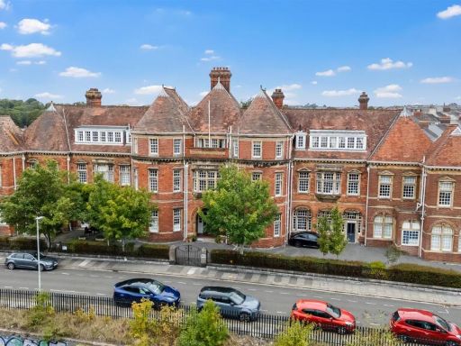 3 bedroom apartment for sale in 15 Apsley Road, Plymouth, PL4 — £410,000 • 3 bed • 3 bath • 1874 ft²
 1 bedroom terraced house for sale in Bayswater Road, Plymouth, Devon, PL1 — £100,000 • 1 bed • 1 bath • 1271 ft²
 1 bedroom apartment for sale in Baring Street, Plymouth, Devon, PL4 — £89,000 • 1 bed • 1 bath • 699 ft²
Meta
- {
"@context": "https://schema.org",
"@type": "Residence",
"name": "Commercial property for sale in Office 8 R.E.I., 15 Apsley…",
"description": "",
"url": "https://propertypiper.co.uk/property/b744923b-7358-4503-93e4-654c96098ed0",
"image": "https://image-a.propertypiper.co.uk/7f2a32d0-12e8-4afb-b823-33e7e1d66cf4-1024.jpeg",
"address": {
"@type": "PostalAddress",
"streetAddress": "Flat 8, 15 Apsley Road",
"postalCode": "PL4 6AR",
"addressLocality": "Plymouth",
"addressRegion": "Plymouth, Sutton and Devonport",
"addressCountry": "England"
},
"geo": {
"@type": "GeoCoordinates",
"latitude": 50.38058496353904,
"longitude": -4.139028030674896
},
"numberOfRooms": 1,
"numberOfBathroomsTotal": 1,
"floorSize": {
"@type": "QuantitativeValue",
"value": 1217,
"unitCode": "FTK"
},
"offers": {
"@type": "Offer",
"price": 27000,
"priceCurrency": "GBP",
"availability": "https://schema.org/InStock"
},
"additionalProperty": [
{
"@type": "PropertyValue",
"name": "Feature",
"value": "Victorian"
},
{
"@type": "PropertyValue",
"name": "Feature",
"value": "red brick"
},
{
"@type": "PropertyValue",
"name": "Feature",
"value": "arched windows"
},
{
"@type": "PropertyValue",
"name": "Feature",
"value": "three-story"
},
{
"@type": "PropertyValue",
"name": "Feature",
"value": "residential"
},
{
"@type": "PropertyValue",
"name": "Feature",
"value": "terraced house"
},
{
"@type": "PropertyValue",
"name": "Feature",
"value": "traditional architecture"
},
{
"@type": "PropertyValue",
"name": "Feature",
"value": "historic"
},
{
"@type": "PropertyValue",
"name": "Feature",
"value": "Victorian"
},
{
"@type": "PropertyValue",
"name": "Feature",
"value": "period property"
},
{
"@type": "PropertyValue",
"name": "Feature",
"value": "red brick"
},
{
"@type": "PropertyValue",
"name": "Feature",
"value": "high ceilings"
},
{
"@type": "PropertyValue",
"name": "Feature",
"value": "arched windows"
},
{
"@type": "PropertyValue",
"name": "Feature",
"value": "mansard roof"
},
{
"@type": "PropertyValue",
"name": "Feature",
"value": "gated access"
},
{
"@type": "PropertyValue",
"name": "Feature",
"value": "street-facing"
}
]
}