DT10 2PQ - 3 bedroom end of terrace house for sale in Lower Road, Stal…
View on Property Piper
3 bedroom end of terrace house for sale in Lower Road,
Stalbridge,
Sturminster Newton,
Dorset,
DT10 2PQ, DT10
Property Details
- Price: £318500
- Bedrooms: 3
- Bathrooms: 1
- Property Type: undefined
- Property SubType: undefined
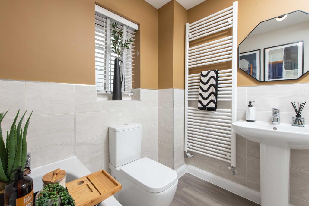
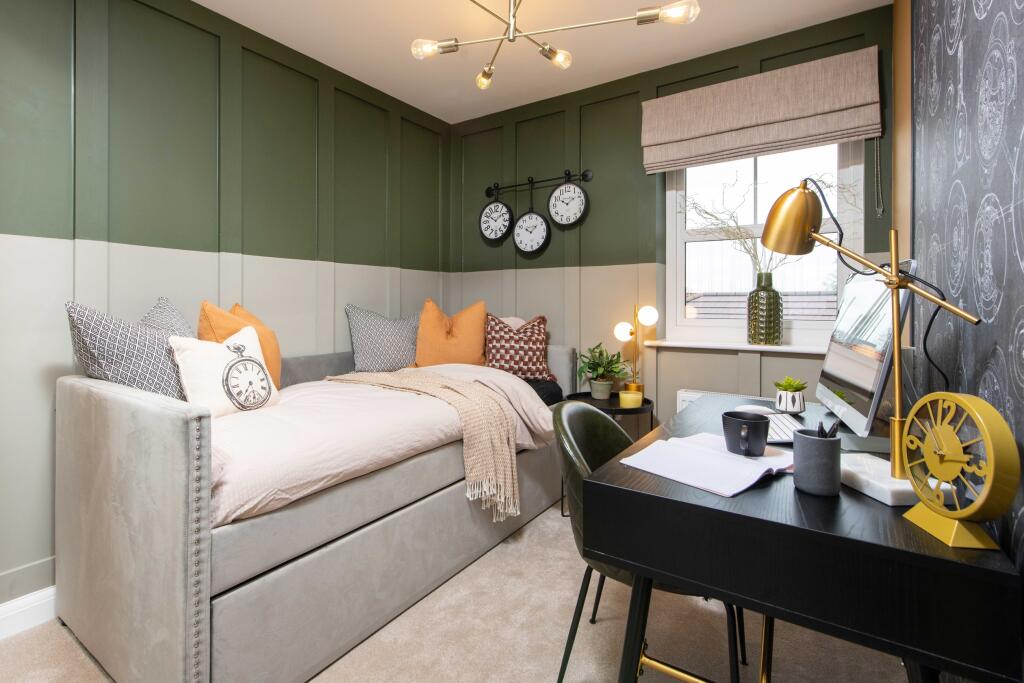
Image Descriptions
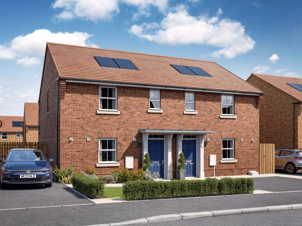
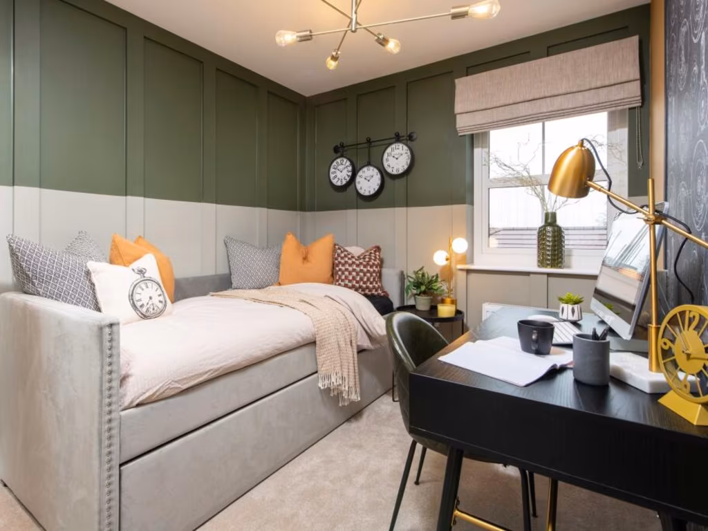
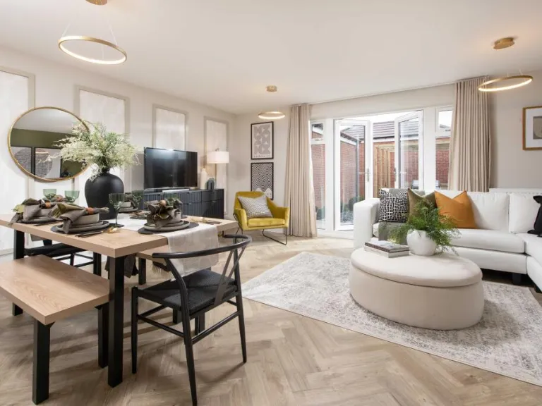
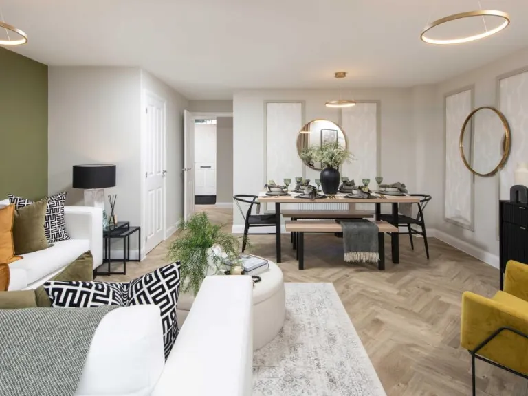
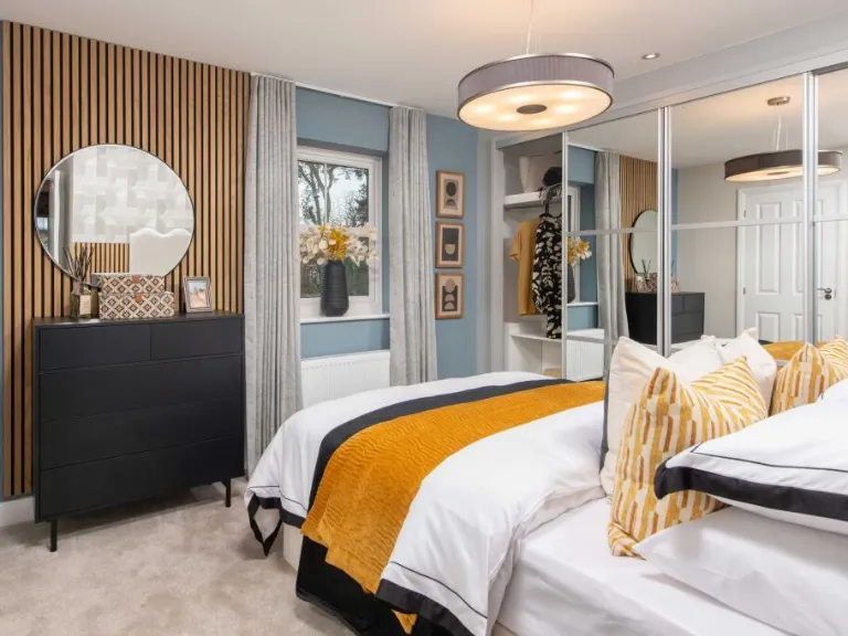
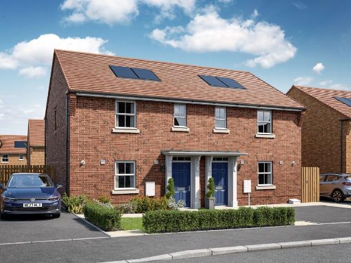
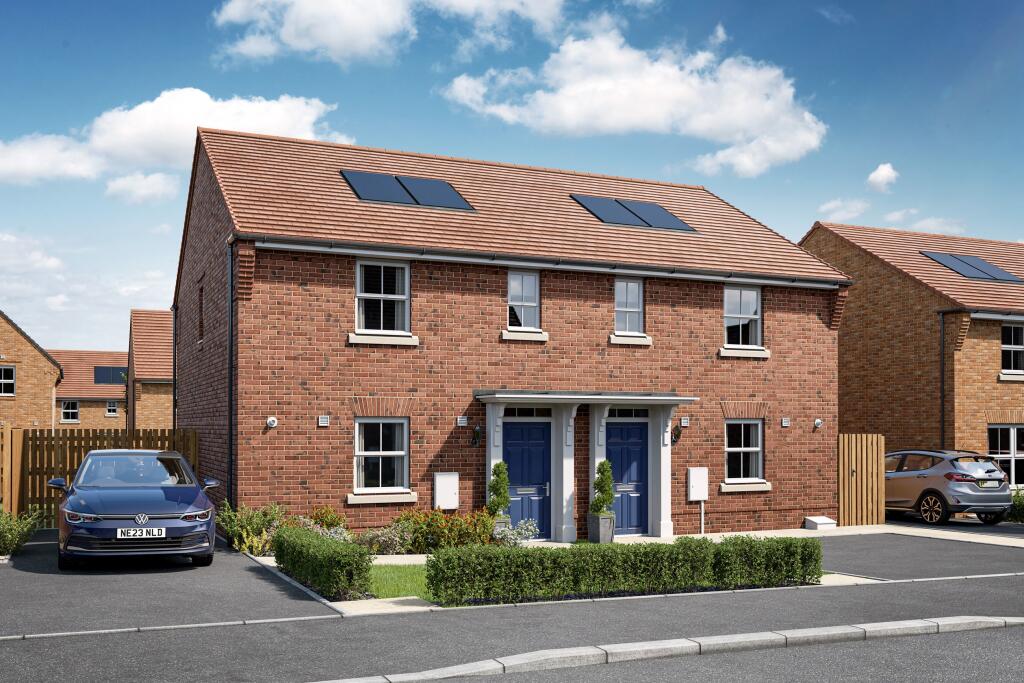
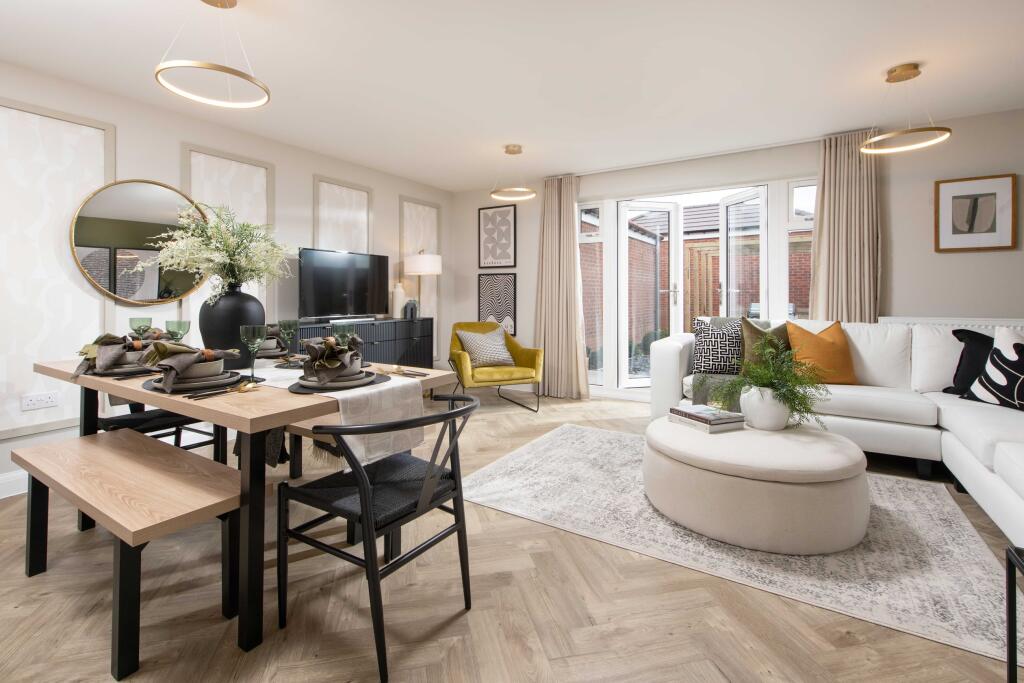
- semi-detached house Modern
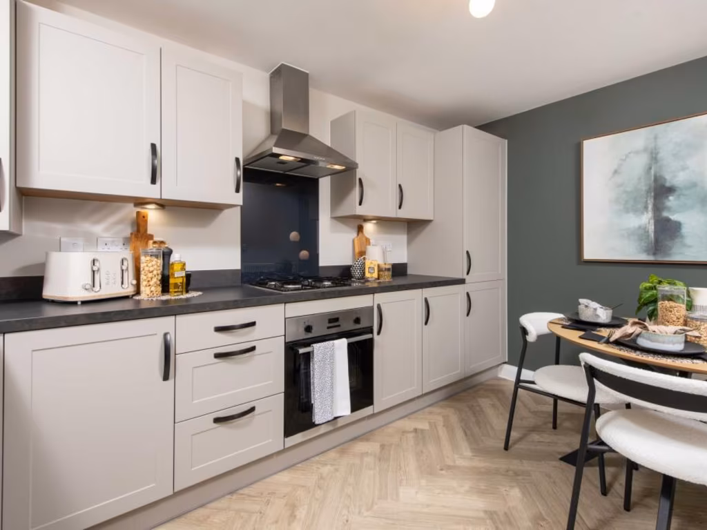
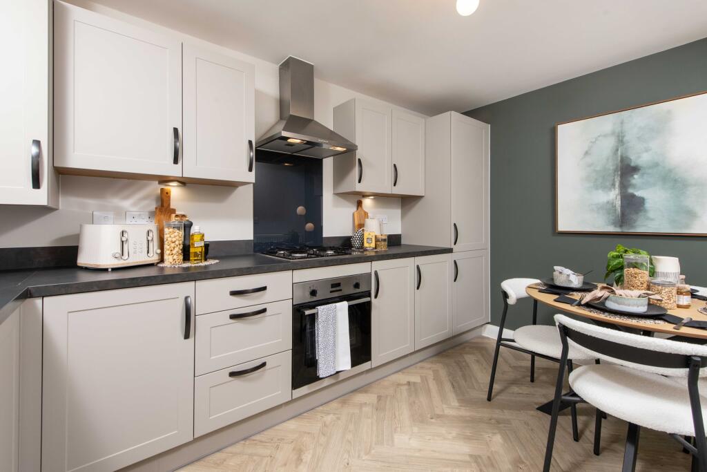
- kitchen modern
Floorplan Description
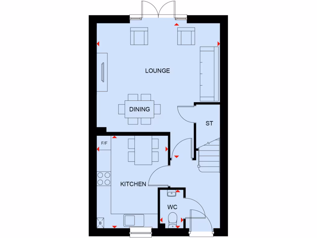
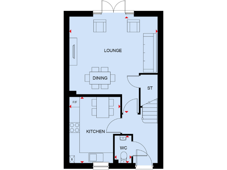
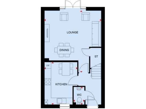
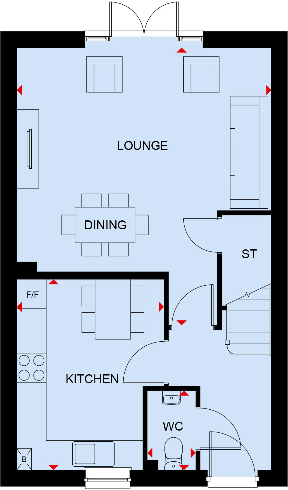
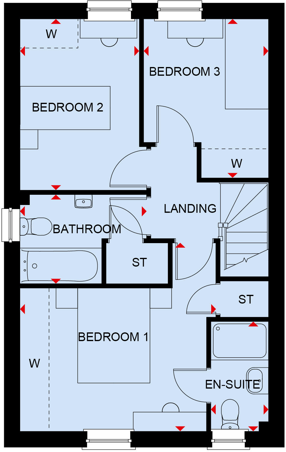
- The floorplan includes a lounge, dining area, kitchen, store, and a WC.
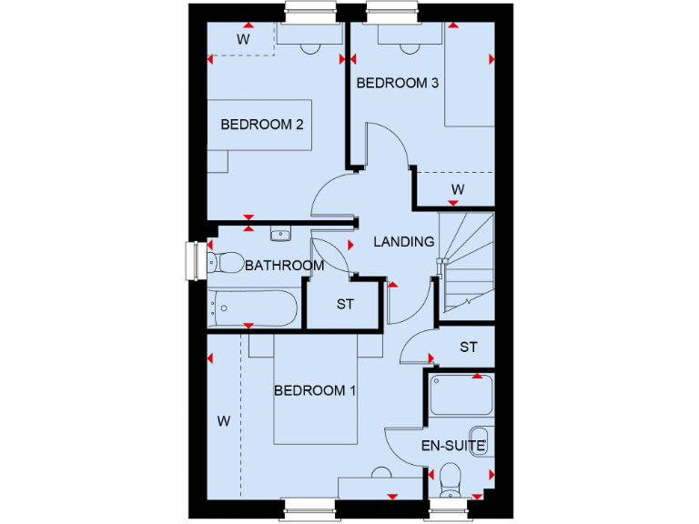
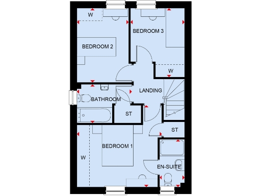
- A layout featuring three bedrooms, a bathroom, and an en-suite bathroom.
Rooms
- Lounge:
- Dining:
- Kitchen:
- Store (ST):
- WC:
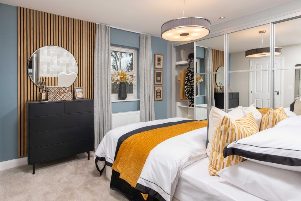
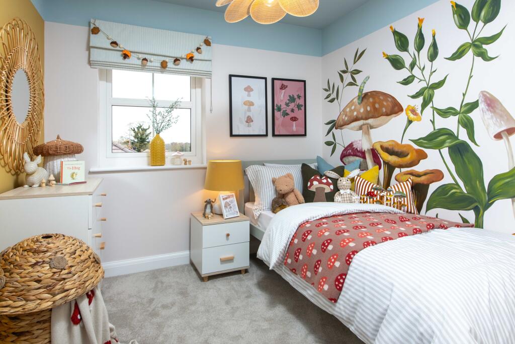
- Bedroom 1:
- Bedroom 2:
- Bedroom 3:
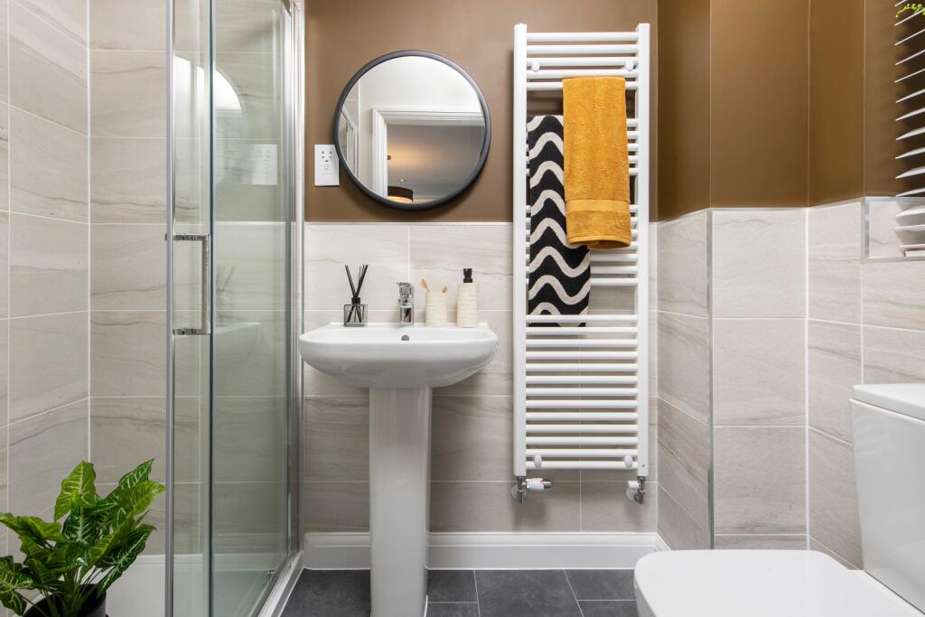
- Bathroom:
- En-Suite:
- Landing:
Textual Property Features
- Is New Build
- Has Garden
- Success
Detected Visual Features
- modern
- semi-detached
- new build
- solar panels
- driveway
- garden
- energy efficient
- modern kitchen
- integrated appliances
- wood flooring
- bright
- neutral decor
EPC Details
- Fully double glazed
- Cavity wall, as built, partial insulation (assumed)
- Electric storage heaters
- Low energy lighting in 67% of fixed outlets
- Suspended, no insulation (assumed)
Nearby Schools
- Abbas and Templecombe Church School
- Sturminster Newton High School
- Milborne Port Primary School
- St Mary's Catholic Primary School, Marnhull
- Horsington Church School
- William Barnes Primary School
- Stower Provost Community School
- All Saints Church of England Voluntary Controlled Primary School
- Stalbridge Church of England Primary School
Nearest Bars And Restaurants
- Id: 504018534
- Tags:
- Amenity: fast_food
- Cuisine: chinese
- TagsNormalized:
- Lat: 50.9592972
- Lon: -2.3784422
- FullGeoHash: gcn3cuu56m8b
- PartitionGeoHash: gcn3
- Images:
- FoodStandards: null
- Distance: 592.9
,- Id: 5277755885
- Tags:
- TagsNormalized:
- Lat: 50.9593488
- Lon: -2.3782473
- FullGeoHash: gcn3cuu5wz4k
- PartitionGeoHash: gcn3
- Images:
- FoodStandards: null
- Distance: 586.4
,- Id: 504018533
- Tags:
- Amenity: fast_food
- Cuisine: fish_and_chips
- TagsNormalized:
- Lat: 50.9593559
- Lon: -2.3781715
- FullGeoHash: gcn3cuu7b86y
- PartitionGeoHash: gcn3
- Images:
- FoodStandards: null
- Distance: 582.9
,- Id: 501567516
- Tags:
- TagsNormalized:
- Lat: 50.9586961
- Lon: -2.3786659
- FullGeoHash: gcn3cuezvj6n
- PartitionGeoHash: gcn3
- Images:
- FoodStandards: null
- Distance: 564.8
,- Id: 544636049
- Tags:
- Addr:
- City: Stalbridge
- Postcode: DT10 2NF
- Amenity: pub
- Building: yes
- Name: The Stalbridge Arms
- TagsNormalized:
- Lat: 50.9567006
- Lon: -2.3754336
- FullGeoHash: gcn3cuqk23kr
- PartitionGeoHash: gcn3
- Images:
- FoodStandards: null
- Distance: 259.1
}
Nearest General Shops
- Id: 293687187
- Tags:
- Addr:
- Postcode: DT10 2LH
- Street: High Street
- Fhrs:
- Name: Roger Else
- Shop: butcher
- Source:
- TagsNormalized:
- Lat: 50.9595229
- Lon: -2.3785617
- FullGeoHash: gcn3cuguxrxf
- PartitionGeoHash: gcn3
- Images:
- FoodStandards:
- Id: 993980
- FHRSID: 993980
- LocalAuthorityBusinessID: 445
- BusinessName: Else Butchers Ltd
- BusinessType: Retailers - other
- BusinessTypeID: 4613
- AddressLine1: Else Butchers Ltd High Street
- AddressLine2: null
- AddressLine3: Stalbridge
- AddressLine4: Dorset
- PostCode: DT10 2LH
- RatingValue: 5
- RatingKey: fhrs_5_en-GB
- RatingDate: 2022-11-30
- LocalAuthorityCode: 085
- LocalAuthorityName: Dorset
- LocalAuthorityWebSite: https://www.dorsetcouncil.gov.uk/
- LocalAuthorityEmailAddress: envhealthteamb@dorsetcouncil.gov.uk
- Scores:
- Hygiene: 0
- Structural: 5
- ConfidenceInManagement: 5
- NewRatingPending: false
- Geocode:
- Longitude: -2.37874889373779
- Latitude: 50.96002578735350
- Distance: 615.7
,- Id: 506710767
- Tags:
- TagsNormalized:
- Lat: 50.9601904
- Lon: -2.3770524
- FullGeoHash: gcn3cvj0dsj2
- PartitionGeoHash: gcn3
- Images:
- FoodStandards: null
- Distance: 599.4
,- Id: 204959988
- Tags:
- Addr:
- Postcode: DT10 2NB
- Street: Ring Street
- Building: yes
- Fhrs:
- Name: Dike & Son
- Shop: supermarket
- TagsNormalized:
- Lat: 50.9586372
- Lon: -2.3788222
- FullGeoHash: gcn3cuez96mx
- PartitionGeoHash: gcn3
- Images:
- FoodStandards:
- Id: 993697
- FHRSID: 993697
- LocalAuthorityBusinessID: 134
- BusinessName: Dike and Son Limited
- BusinessType: Retailers - supermarkets/hypermarkets
- BusinessTypeID: 7840
- AddressLine1: Dike And Son Ltd Ring Street
- AddressLine2: null
- AddressLine3: Stalbridge
- AddressLine4: Dorset
- PostCode: DT10 2NB
- RatingValue: 5
- RatingKey: fhrs_5_en-GB
- RatingDate: 2021-09-17
- LocalAuthorityCode: 085
- LocalAuthorityName: Dorset
- LocalAuthorityWebSite: https://www.dorsetcouncil.gov.uk/
- LocalAuthorityEmailAddress: envhealthteamb@dorsetcouncil.gov.uk
- Scores:
- Hygiene: 0
- Structural: 0
- ConfidenceInManagement: 0
- NewRatingPending: false
- Geocode:
- Longitude: -2.37871003150940
- Latitude: 50.95872116088870
- Distance: 570.3
}
Nearest Grocery shops
- Id: 296573162
- Tags:
- Addr:
- Postcode: DT10 1PH
- Street: Burton Street
- Fhrs:
- Name: Robin Hill Stores
- Shop: convenience
- Source:
- TagsNormalized:
- Lat: 50.9735753
- Lon: -2.322766
- FullGeoHash: gcn3gpkweehh
- PartitionGeoHash: gcn3
- Images:
- FoodStandards: null
- Distance: 3971.6
,- Id: 2100436750
- Tags:
- Addr:
- Housename: Marnhull Stores
- Postcode: DT10 1PX
- Street: New Street
- Alt_name: Spar Stores
- Fhrs:
- Name: Marnhull Stores
- Shop: convenience
- Source: survey
- TagsNormalized:
- Lat: 50.9653234
- Lon: -2.3196403
- FullGeoHash: gcn3gjyys2yu
- PartitionGeoHash: gcn3
- Images:
- FoodStandards: null
- Distance: 3815.3
,- Id: 204955006
- Tags:
- Addr:
- Building: yes
- Name: Late Stop
- Shop: convenience
- TagsNormalized:
- Lat: 50.9769489
- Lon: -2.3942501
- FullGeoHash: gcn6180d3bj8
- PartitionGeoHash: gcn6
- Images:
- FoodStandards: null
- Distance: 2817.3
}
Nearest Religious buildings
- Id: 204953481
- Tags:
- Amenity: place_of_worship
- Denomination: anglican
- Name: St Nicholas
- Religion: christian
- Wikidata: Q17554916
- Wikipedia: en:Church of St Nicholas, Henstridge
- TagsNormalized:
- place of worship
- anglican
- christian
- church
- Lat: 50.9765987
- Lon: -2.3962243
- FullGeoHash: gcn612p05ytx
- PartitionGeoHash: gcn6
- Images:
- FoodStandards: null
- Distance: 2864.6
,- Id: 85942775
- Tags:
- Amenity: place_of_worship
- Building: church
- Denomination: anglican
- Name: St Mary
- Religion: christian
- Wikidata: Q17538965
- TagsNormalized:
- place of worship
- church
- anglican
- christian
- Lat: 50.9625274
- Lon: -2.3808857
- FullGeoHash: gcn3cv6q1rdv
- PartitionGeoHash: gcn3
- Images:
- FoodStandards: null
- Distance: 969.7
,- Id: 405364302
- Tags:
- Addr:
- Postcode: DT10 2LP
- Street: Duck Lane
- Amenity: school
- Denomination: anglican
- Diocese: Diocese of Salisbury
- Fhrs:
- Isced:
- Max_age: 11
- Min_age: 4
- Name: Stalbridge Church of England Primary School
- Phone: +44 1963362487
- Ref:
- Religion: christian
- School:
- Source:
- Website: https://www.stalbridge.dorset.sch.uk/
- TagsNormalized:
- school
- anglican
- church
- christian
- Lat: 50.9619098
- Lon: -2.3772153
- FullGeoHash: gcn3cvkfwuec
- PartitionGeoHash: gcn3
- Images:
- FoodStandards:
- Id: 994436
- FHRSID: 994436
- LocalAuthorityBusinessID: 999
- BusinessName: Local Food Links (Stalbridge Primary)
- BusinessType: School/college/university
- BusinessTypeID: 7845
- AddressLine1: Stalbridge C Of E Primary School Duck Lane
- AddressLine2: null
- AddressLine3: Stalbridge
- AddressLine4: Dorset
- PostCode: DT10 2LP
- RatingValue: 5
- RatingKey: fhrs_5_en-GB
- RatingDate: 2022-01-26
- LocalAuthorityCode: 085
- LocalAuthorityName: Dorset
- LocalAuthorityWebSite: https://www.dorsetcouncil.gov.uk/
- LocalAuthorityEmailAddress: envhealthteamb@dorsetcouncil.gov.uk
- Scores:
- Hygiene: 0
- Structural: 0
- ConfidenceInManagement: 0
- NewRatingPending: false
- Geocode:
- Longitude: -2.37753295898438
- Latitude: 50.96112060546880
- Distance: 767.4
}
Nearest Airports
- Id: 386864426
- Tags:
- Aerodrome: international
- Aeroway: aerodrome
- Alt_name: Bournemouth International Airport
- Ele: 12
- Iata: BOH
- Icao: EGHH
- Int_name: B
- Name: Bournemouth Airport
- Old_name: Hurn Airport
- Ref: EGHH
- Source: wikipedia
- Wikidata: Q580409
- Wikipedia: en:Bournemouth Airport
- TagsNormalized:
- airport
- international airport
- Lat: 50.7825186
- Lon: -1.84232
- FullGeoHash: gcn8yhdmwgde
- PartitionGeoHash: gcn8
- Images:
- FoodStandards: null
- Distance: 41868.9
}
Nearest Leisure Facilities
- Id: 224330877
- Tags:
- Leisure: park
- Name: Stalbridge Recreation Area Play Park
- TagsNormalized:
- Lat: 50.9571736
- Lon: -2.3849772
- FullGeoHash: gcn3csrr418h
- PartitionGeoHash: gcn3
- Images:
- FoodStandards: null
- Distance: 921.3
,- Id: 544429938
- Tags:
- Leisure: pitch
- Sport: soccer
- TagsNormalized:
- Lat: 50.9622085
- Lon: -2.3763766
- FullGeoHash: gcn3cvms6kjp
- PartitionGeoHash: gcn3
- Images:
- FoodStandards: null
- Distance: 771.6
,- Id: 85642362
- Tags:
- TagsNormalized:
- swimming
- swimming pool
- pool
- leisure
- Lat: 50.9616795
- Lon: -2.3778956
- FullGeoHash: gcn3cvk3r18e
- PartitionGeoHash: gcn3
- Images:
- FoodStandards: null
- Distance: 769.5
,- Id: 544429937
- Tags:
- Access: private
- Leisure: playground
- TagsNormalized:
- Lat: 50.9616782
- Lon: -2.3774621
- FullGeoHash: gcn3cvkc317g
- PartitionGeoHash: gcn3
- Images:
- FoodStandards: null
- Distance: 753.5
,- Id: 973160628
- Tags:
- TagsNormalized:
- Lat: 50.9585326
- Lon: -2.3704154
- FullGeoHash: gcn3fh9yvqfp
- PartitionGeoHash: gcn3
- Images:
- FoodStandards: null
- Distance: 319
}
Nearest Tourist attractions
- Id: 3992493126
- Tags:
- Name: Woodlands Farm Bed and Breakfast
- Tourism: guest_house
- TagsNormalized:
- bed
- farm
- guest house
- tourism
- Lat: 50.9222256
- Lon: -2.3357942
- FullGeoHash: gcn3dy55knce
- PartitionGeoHash: gcn3
- Images:
- FoodStandards: null
- Distance: 4517.4
,- Id: 2463268049
- Tags:
- Name: Blackmore Farmhouse Cottage B&B
- Tourism: guest_house
- TagsNormalized:
- Lat: 50.9219324
- Lon: -2.3656801
- FullGeoHash: gcn3dnj3g8jn
- PartitionGeoHash: gcn3
- Images:
- FoodStandards: null
- Distance: 3796.5
,- Id: 413719705
- Tags:
- TagsNormalized:
- Lat: 50.9840022
- Lon: -2.3673446
- FullGeoHash: gcn641k5kfgg
- PartitionGeoHash: gcn6
- Images:
- FoodStandards: null
- Distance: 3148.1
}
Nearest Train stations
- Id: 6011304342
- Tags:
- Name: Gillingham
- Naptan:
- Network: National Rail
- Public_transport: station
- Railway: station
- Ref:
- Wheelchair: yes
- Wikidata: Q2731470
- Wikipedia: en:Gillingham railway station (Dorset)
- TagsNormalized:
- Lat: 51.0340876
- Lon: -2.2720765
- FullGeoHash: gcn6k63x0g2y
- PartitionGeoHash: gcn6
- Images:
- FoodStandards: null
- Distance: 11162.3
,- Id: 6013523221
- Tags:
- Name: Sherborne
- Naptan:
- Network: National Rail
- Public_transport: station
- Railway: station
- Ref:
- Source: gps_survey
- Wikidata: Q2407888
- Wikipedia: en:Sherborne railway station
- TagsNormalized:
- Lat: 50.943979
- Lon: -2.5129696
- FullGeoHash: gcn1yf445tfp
- PartitionGeoHash: gcn1
- Images:
- FoodStandards: null
- Distance: 9963.4
,- Id: 6011304340
- Tags:
- Name: Templecombe
- Naptan:
- Network: National Rail
- Public_transport: station
- Railway: station
- Ref:
- Wikidata: Q1901020
- Wikipedia: en:Templecombe railway station
- TagsNormalized:
- Lat: 51.001594
- Lon: -2.4172852
- FullGeoHash: gcn60uxcc4jw
- PartitionGeoHash: gcn6
- Images:
- FoodStandards: null
- Distance: 5994.6
,- Id: 9991604554
- Tags:
- Name: Common Lane
- Network: Gartell Light Railway
- Operator: Gartell Light Railway
- Public_transport: station
- Railway: station
- Train: yes
- Usage: tourism
- TagsNormalized:
- Lat: 50.9949551
- Lon: -2.4024297
- FullGeoHash: gcn6176e5kds
- PartitionGeoHash: gcn6
- Images:
- FoodStandards: null
- Distance: 4843.1
,- Id: 9991604612
- Tags:
- Name: Pinesway Junction
- Public_transport: station
- Railway: station
- Train: yes
- Usage: tourism
- TagsNormalized:
- Lat: 50.9936437
- Lon: -2.4036374
- FullGeoHash: gcn6171ex0nj
- PartitionGeoHash: gcn6
- Images:
- FoodStandards: null
- Distance: 4751.5
}
Nearest Bus stations and stops
- Id: 4885531824
- Tags:
- Bus: yes
- Highway: bus_stop
- Public_transport: platform
- TagsNormalized:
- Lat: 50.9267203
- Lon: -2.3033242
- FullGeoHash: gcn3ewfv8ssz
- PartitionGeoHash: gcn3
- Images:
- FoodStandards: null
- Distance: 5799.7
,- Id: 4885531823
- Tags:
- Bus: yes
- Highway: bus_stop
- Public_transport: platform
- TagsNormalized:
- Lat: 50.9270061
- Lon: -2.3040212
- FullGeoHash: gcn3ewfr26j2
- PartitionGeoHash: gcn3
- Images:
- FoodStandards: null
- Distance: 5741.4
,- Id: 4868308431
- Tags:
- Bus: yes
- Highway: bus_stop
- Public_transport: platform
- TagsNormalized:
- Lat: 50.9331769
- Lon: -2.3051096
- FullGeoHash: gcn3g817r03d
- PartitionGeoHash: gcn3
- Images:
- FoodStandards: null
- Distance: 5320.8
,- Id: 9325317281
- Tags:
- Bus: yes
- Highway: bus_stop
- Public_transport: platform
- Shelter: no
- Source: survey
- TagsNormalized:
- Lat: 50.9222193
- Lon: -2.3632639
- FullGeoHash: gcn3dnp57vww
- PartitionGeoHash: gcn3
- Images:
- FoodStandards: null
- Distance: 3788.4
,- Id: 296573856
- Tags:
- Bus: yes
- Highway: bus_stop
- Public_transport: platform
- TagsNormalized:
- Lat: 50.9797401
- Lon: -2.3984348
- FullGeoHash: gcn612td82m7
- PartitionGeoHash: gcn6
- Images:
- FoodStandards: null
- Distance: 3238.7
}
Nearest Hotels
- Id: 2424818415
- Tags:
- Brand: Travelodge
- Brand:wikidata: Q9361374
- Brand:wikipedia: en:Travelodge UK
- Name: Travelodge
- Tourism: hotel
- TagsNormalized:
- Lat: 51.0492457
- Lon: -2.4192457
- FullGeoHash: gcn62vnr7mps
- PartitionGeoHash: gcn6
- Images:
- FoodStandards: null
- Distance: 10899.6
,- Id: 2125405901
- Tags:
- Name: The Eastbury
- Tourism: hotel
- Wikidata: Q26610005
- TagsNormalized:
- Lat: 50.9479446
- Lon: -2.5109557
- FullGeoHash: gcn1yfg963px
- PartitionGeoHash: gcn1
- Images:
- FoodStandards: null
- Distance: 9773.7
,- Id: 2396549477
- Tags:
- Name: The Kings Arms
- Tourism: hotel
- TagsNormalized:
- Lat: 51.0073071
- Lon: -2.4793351
- FullGeoHash: gcn4ptde571y
- PartitionGeoHash: gcn4
- Images:
- FoodStandards: null
- Distance: 9445.3
}
Tags
- modern
- semi-detached
- new build
- solar panels
- driveway
- garden
- energy efficient
- modern kitchen
- integrated appliances
- wood flooring
- bright
- neutral decor
Local Market Stats
- Average Price/sqft: £304
- Avg Income: £45800
- Social Housing: 7%
- Planning Success Rate: 86%
Similar Properties
 3 bedroom semi-detached house for sale in Lower Road,
Stalbridge,
Sturminster Newton,
Dorset,
DT10 2PQ, DT10 — £325,000 • 3 bed • 1 bath • 756 ft²
3 bedroom semi-detached house for sale in Lower Road,
Stalbridge,
Sturminster Newton,
Dorset,
DT10 2PQ, DT10 — £325,000 • 3 bed • 1 bath • 756 ft²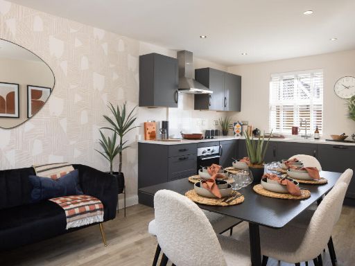 3 bedroom semi-detached house for sale in Lower Road,
Stalbridge,
Sturminster Newton,
Dorset,
DT10 2PQ, DT10 — £335,000 • 3 bed • 1 bath • 810 ft²
3 bedroom semi-detached house for sale in Lower Road,
Stalbridge,
Sturminster Newton,
Dorset,
DT10 2PQ, DT10 — £335,000 • 3 bed • 1 bath • 810 ft²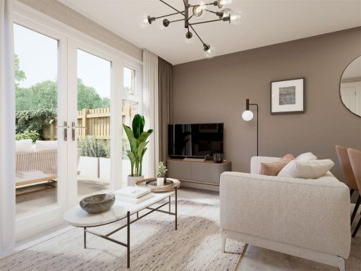 2 bedroom semi-detached house for sale in Lower Road,
Stalbridge,
Sturminster Newton,
Dorset,
DT10 2PQ, DT10 — £267,500 • 2 bed • 1 bath • 506 ft²
2 bedroom semi-detached house for sale in Lower Road,
Stalbridge,
Sturminster Newton,
Dorset,
DT10 2PQ, DT10 — £267,500 • 2 bed • 1 bath • 506 ft²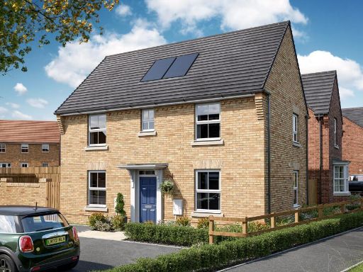 3 bedroom semi-detached house for sale in Lower Road,
Stalbridge,
Sturminster Newton,
Dorset,
DT10 2PQ, DT10 — £330,000 • 3 bed • 1 bath • 810 ft²
3 bedroom semi-detached house for sale in Lower Road,
Stalbridge,
Sturminster Newton,
Dorset,
DT10 2PQ, DT10 — £330,000 • 3 bed • 1 bath • 810 ft²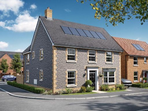 4 bedroom detached house for sale in Lower Road,
Stalbridge,
Sturminster Newton,
Dorset,
DT10 2PQ, DT10 — £510,000 • 4 bed • 1 bath • 1304 ft²
4 bedroom detached house for sale in Lower Road,
Stalbridge,
Sturminster Newton,
Dorset,
DT10 2PQ, DT10 — £510,000 • 4 bed • 1 bath • 1304 ft²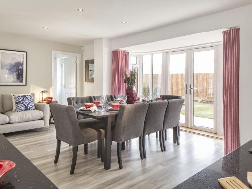 4 bedroom detached house for sale in Lower Road,
Stalbridge,
Sturminster Newton,
Dorset,
DT10 2PQ, DT10 — £485,000 • 4 bed • 1 bath • 1216 ft²
4 bedroom detached house for sale in Lower Road,
Stalbridge,
Sturminster Newton,
Dorset,
DT10 2PQ, DT10 — £485,000 • 4 bed • 1 bath • 1216 ft²
Meta
- {
"@context": "https://schema.org",
"@type": "Residence",
"name": "3 bedroom end of terrace house for sale in Lower Road, Stal…",
"description": "",
"url": "https://propertypiper.co.uk/property/adf714e5-5772-401d-b5a8-c8ba06e12a0b",
"image": "https://image-a.propertypiper.co.uk/701785ca-fe5b-4d25-b0ca-5f728301527c-1024.jpeg",
"address": {
"@type": "PostalAddress",
"streetAddress": "Lower Road, \r\nStalbridge, \r\nSturminster Newton, \r\nDorset, \r\nDT10 2PQ",
"postalCode": "DT10 2PQ",
"addressLocality": "Dorset",
"addressRegion": "North Dorset",
"addressCountry": "England"
},
"geo": {
"@type": "GeoCoordinates",
"latitude": 50.9558422,
"longitude": -2.3719946
},
"numberOfRooms": 3,
"numberOfBathroomsTotal": 1,
"floorSize": {
"@type": "QuantitativeValue",
"value": 756,
"unitCode": "FTK"
},
"offers": {
"@type": "Offer",
"price": 318500,
"priceCurrency": "GBP",
"availability": "https://schema.org/InStock"
},
"additionalProperty": [
{
"@type": "PropertyValue",
"name": "Feature",
"value": "modern"
},
{
"@type": "PropertyValue",
"name": "Feature",
"value": "semi-detached"
},
{
"@type": "PropertyValue",
"name": "Feature",
"value": "new build"
},
{
"@type": "PropertyValue",
"name": "Feature",
"value": "solar panels"
},
{
"@type": "PropertyValue",
"name": "Feature",
"value": "driveway"
},
{
"@type": "PropertyValue",
"name": "Feature",
"value": "garden"
},
{
"@type": "PropertyValue",
"name": "Feature",
"value": "energy efficient"
},
{
"@type": "PropertyValue",
"name": "Feature",
"value": "modern kitchen"
},
{
"@type": "PropertyValue",
"name": "Feature",
"value": "integrated appliances"
},
{
"@type": "PropertyValue",
"name": "Feature",
"value": "wood flooring"
},
{
"@type": "PropertyValue",
"name": "Feature",
"value": "bright"
},
{
"@type": "PropertyValue",
"name": "Feature",
"value": "neutral decor"
}
]
}
High Res Floorplan Images
Compatible Floorplan Images
FloorplanImages Thumbnail