DT10 2PQ - 3 bedroom semidetached house for sale in Lower Road, Stalbr…
View on Property Piper
3 bedroom semi-detached house for sale in Lower Road,
Stalbridge,
Sturminster Newton,
Dorset,
DT10 2PQ, DT10
Property Details
- Price: £335000
- Bedrooms: 3
- Bathrooms: 1
- Property Type: undefined
- Property SubType: undefined
Brochure Descriptions
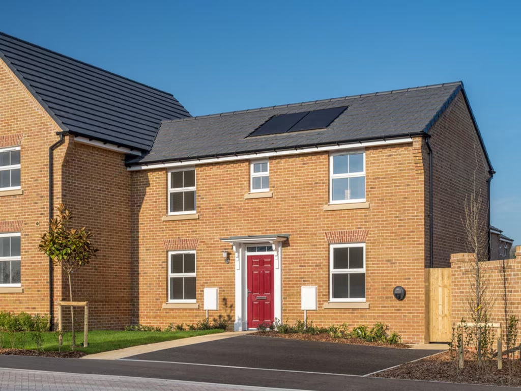
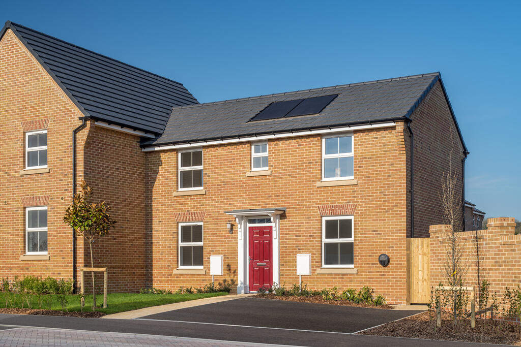
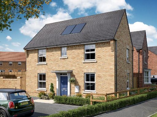
- Listing cover shows only the development name "The Hamlets" by David Wilson Homes. No residential street address or photos of the dwelling are present, so specific property attributes cannot be determined from this image. As a valuator-style appraisal note: this appears to be marketing material for a named residential development rather than a single house listing. Typical implications: likely part of a new-build development with multiple units, standard developer specification, and communal or landscaped grounds. Value drivers to confirm would include exact plot location within the development, dwelling type (detached/semi/terraced/flat), floor area, number of bedrooms/bathrooms, parking provision, garden size, and any local amenity or transport links. Without further images or documentation, an accurate size or market valuation cannot be provided.
- No property images or address are present on this page — the image is a branded marketing cover for David Wilson Homes (website dwh.co.uk, phone 0333 355 8471). There is insufficient information to describe rooms, layout or exact plot location. Likely context: a new‑build residential development marketing cover sheet rather than a specific property photograph. As a valuator, I cannot assess internal condition, floor area or garden size from this image. Recommended next steps: obtain the specific listing or brochure page showing the property address, floorplans, photographs (internal and external), site plan and measured floor area before a valuation. If this is part of a new build brochure, request the plot number and specification to estimate market value.
- No specific residential address is visible in the provided image. The image is a brochure/cover for David Wilson Homes (marketing material) rather than photographs of a single property. From the brochure text and brand it describes new-build homes across the UK: a collection of high‑quality, contemporary houses offering a range of spacious bedroom layouts, marketed as well‑specified homes in desirable locations. Based on this marketing cover alone, one can infer typical features of the product line (new-build, 2–5 bedroom house types, modern finishes, private gardens of small-to-medium size), but no definitive room sizes, exterior views, or total property area can be determined from this image.
Image Descriptions
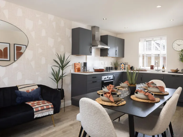
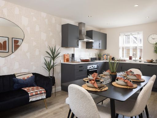
- kitchen contemporary
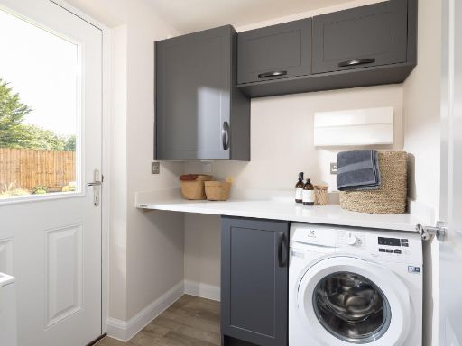
- utility room contemporary
Floorplan Description
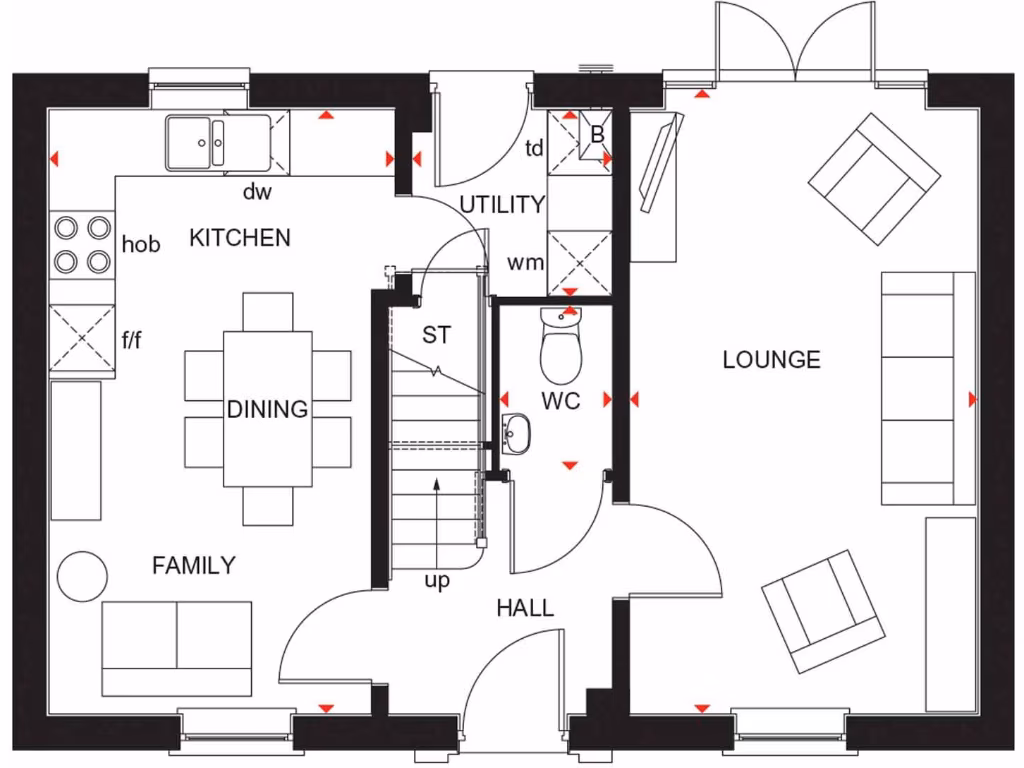
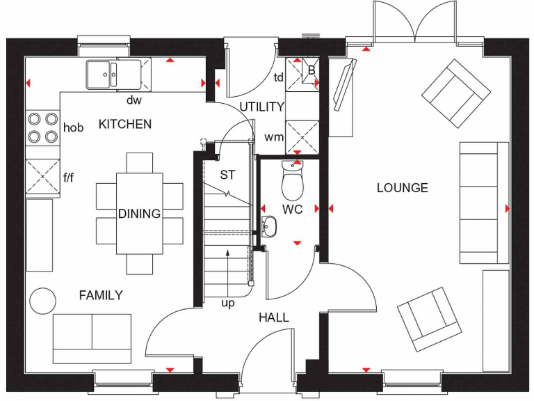
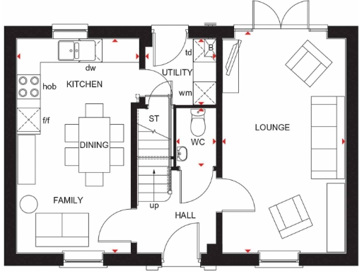
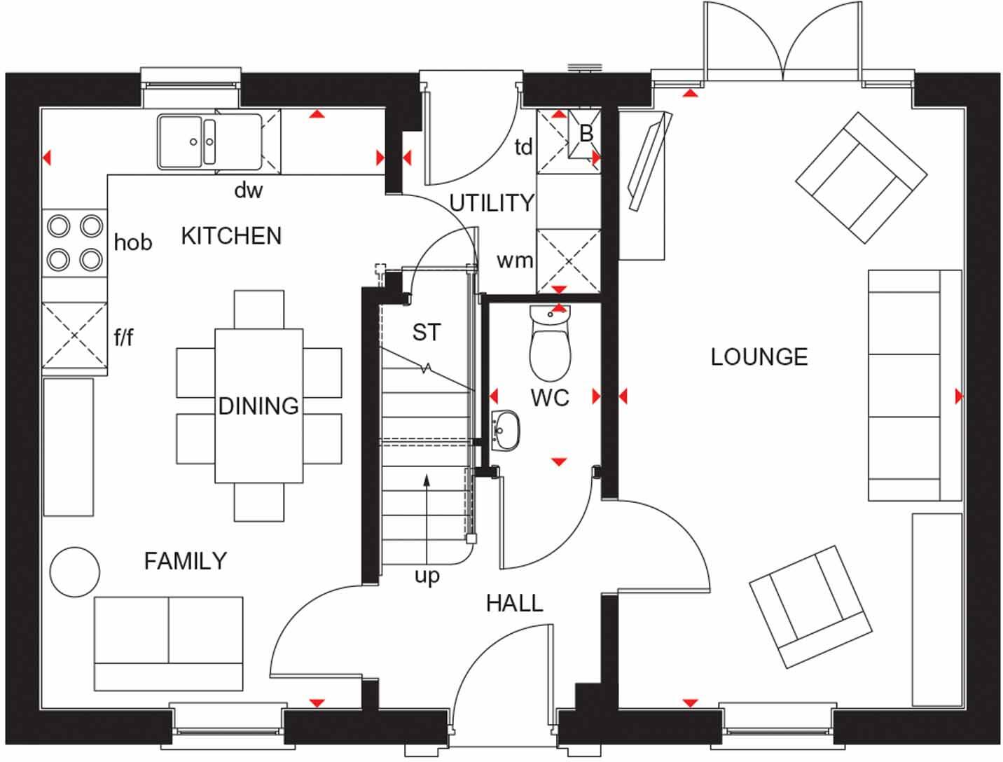
- Floorplan showing labelled rooms: KITCHEN, DINING, FAMILY, LOUNGE, UTILITY, WC, HALL, and ST (stair).
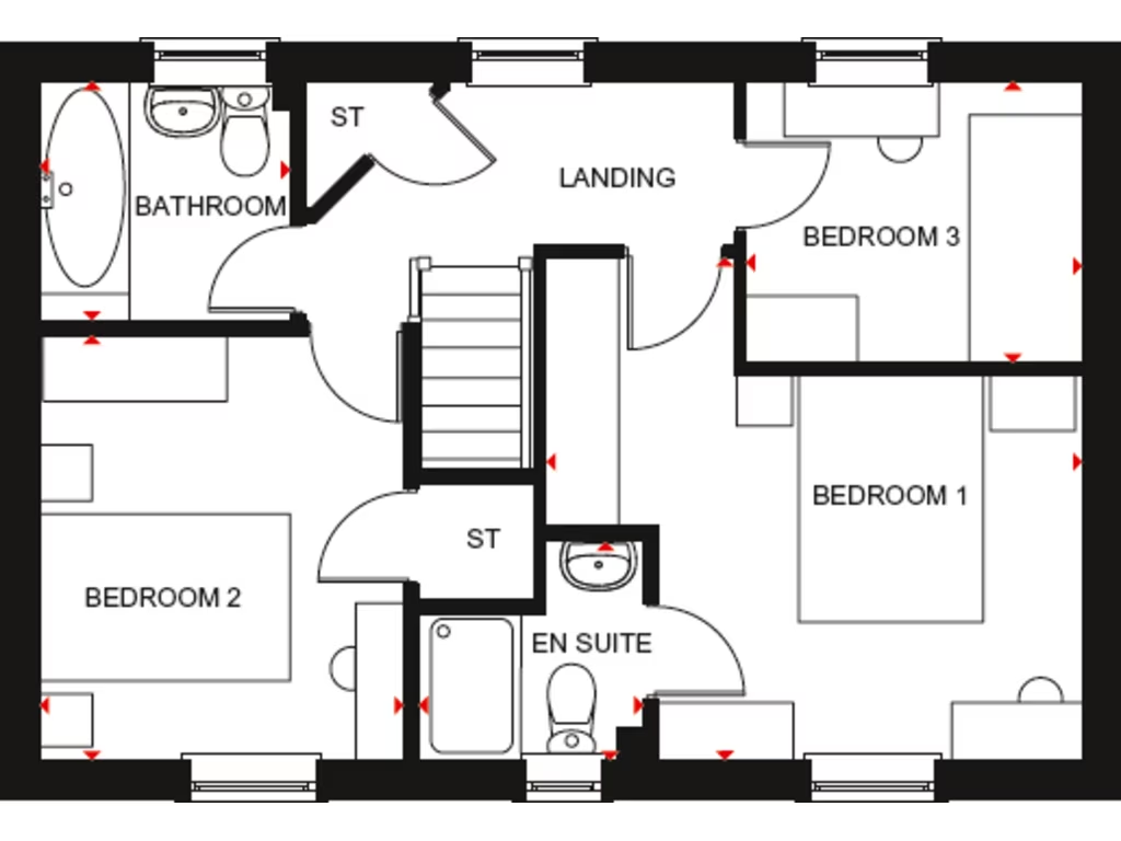
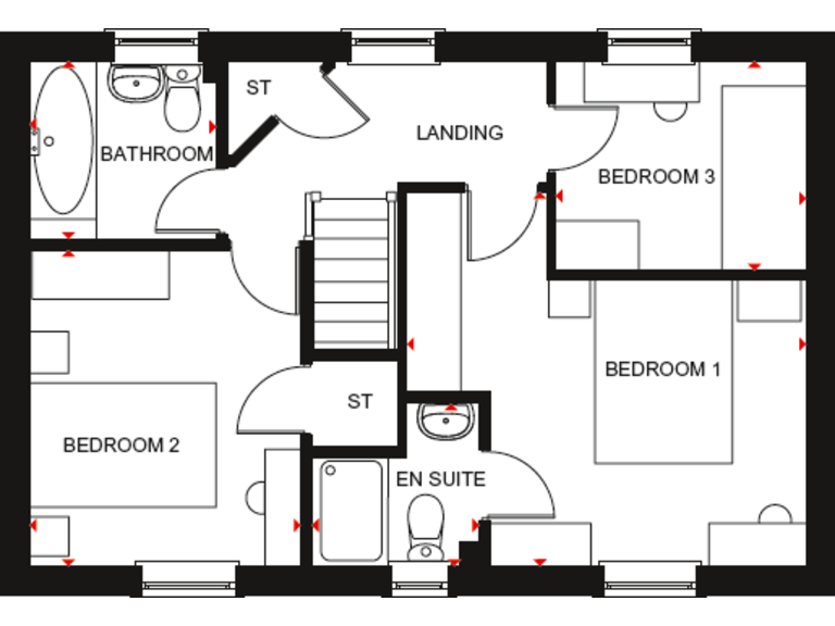
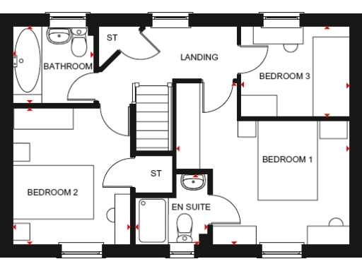
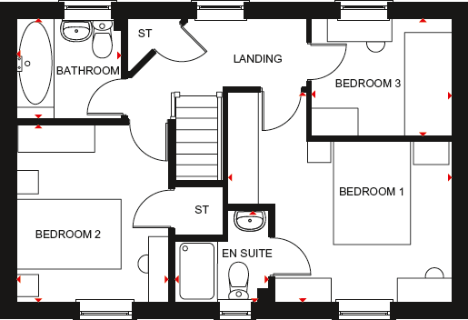
- First-floor plan showing three bedrooms, a bathroom, en suite and landing.
Rooms
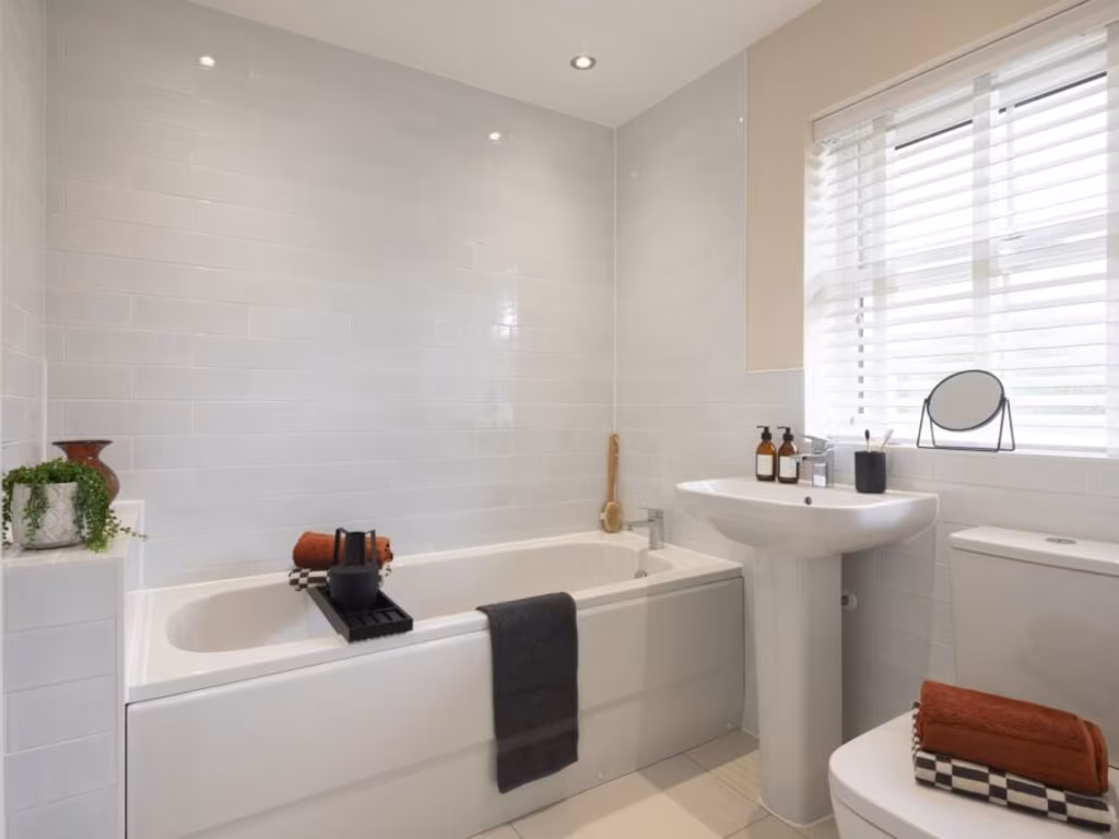
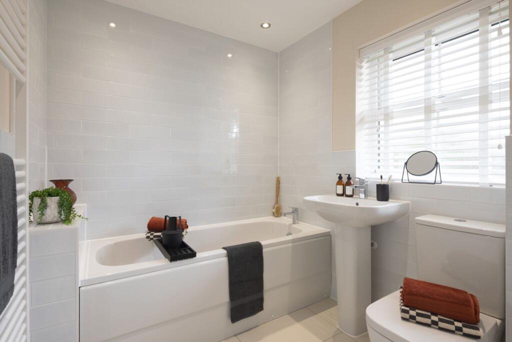
- BATHROOM:
- LANDING:
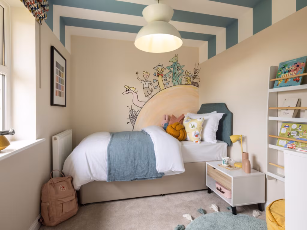
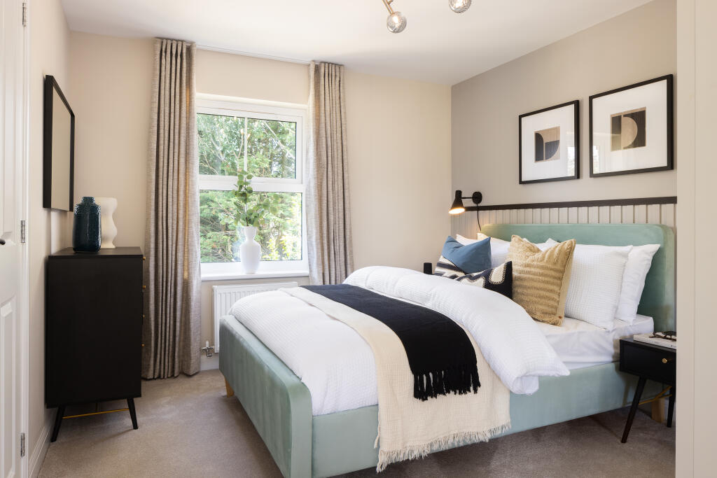
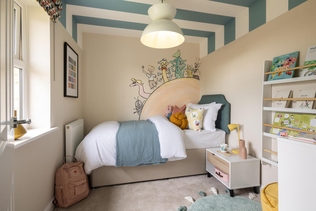
- BEDROOM 3:
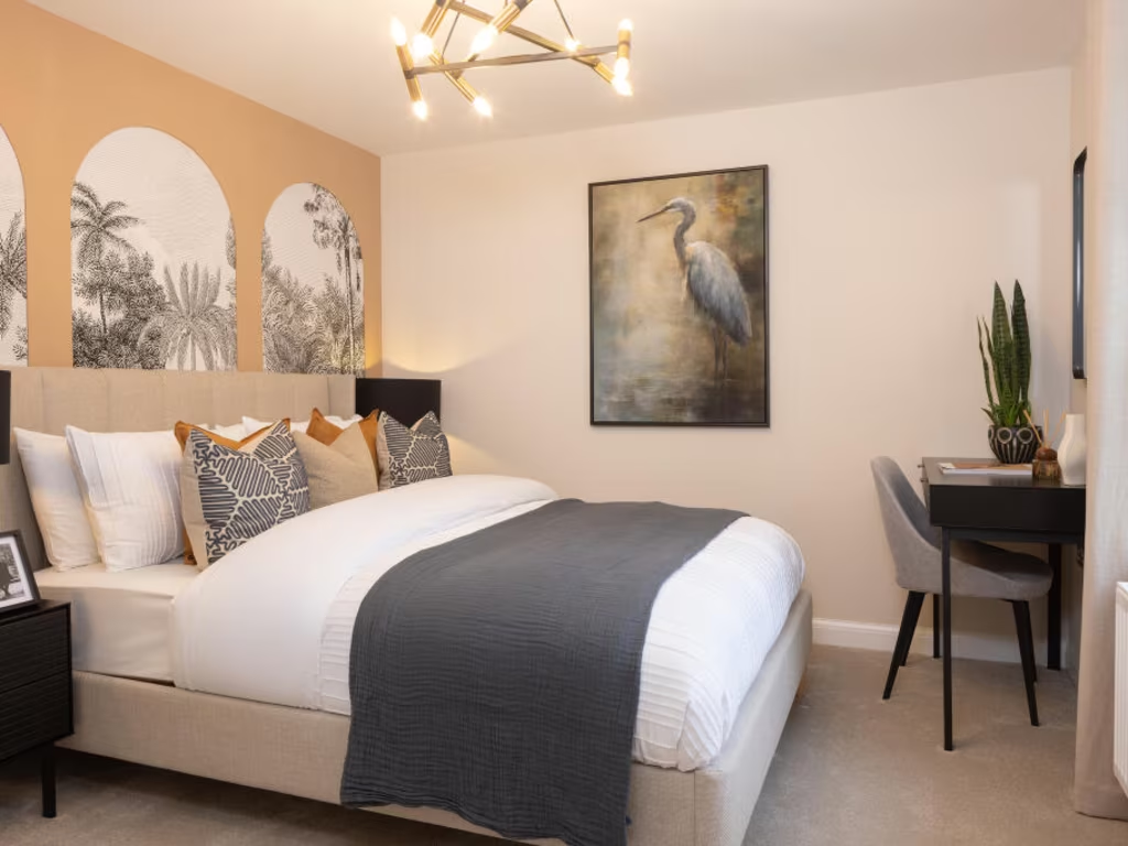
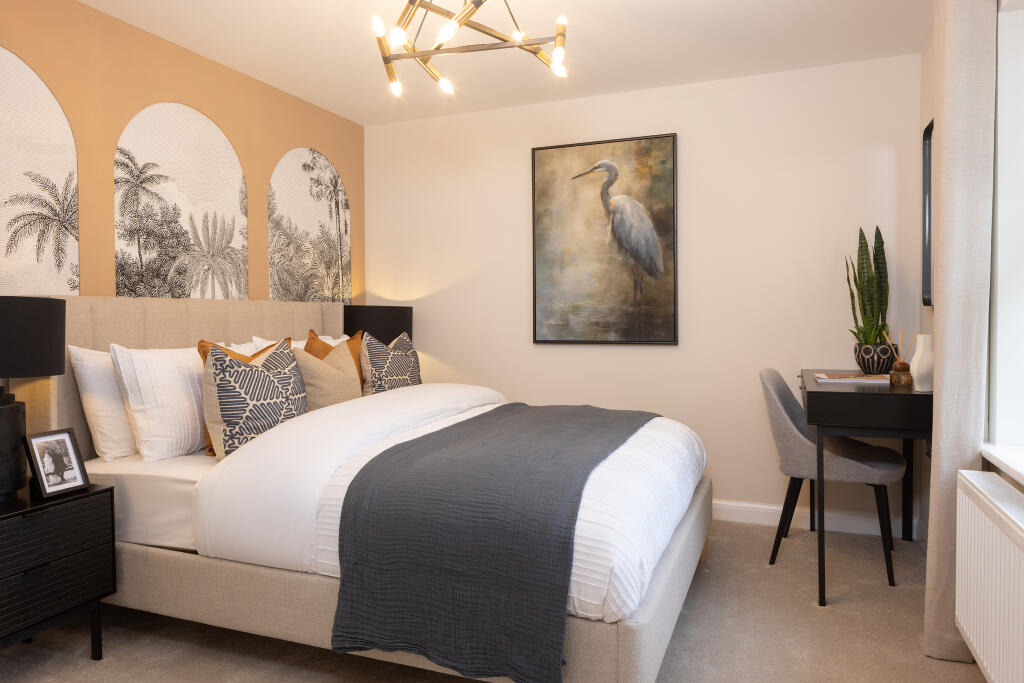
- BEDROOM 1:
- EN SUITE:
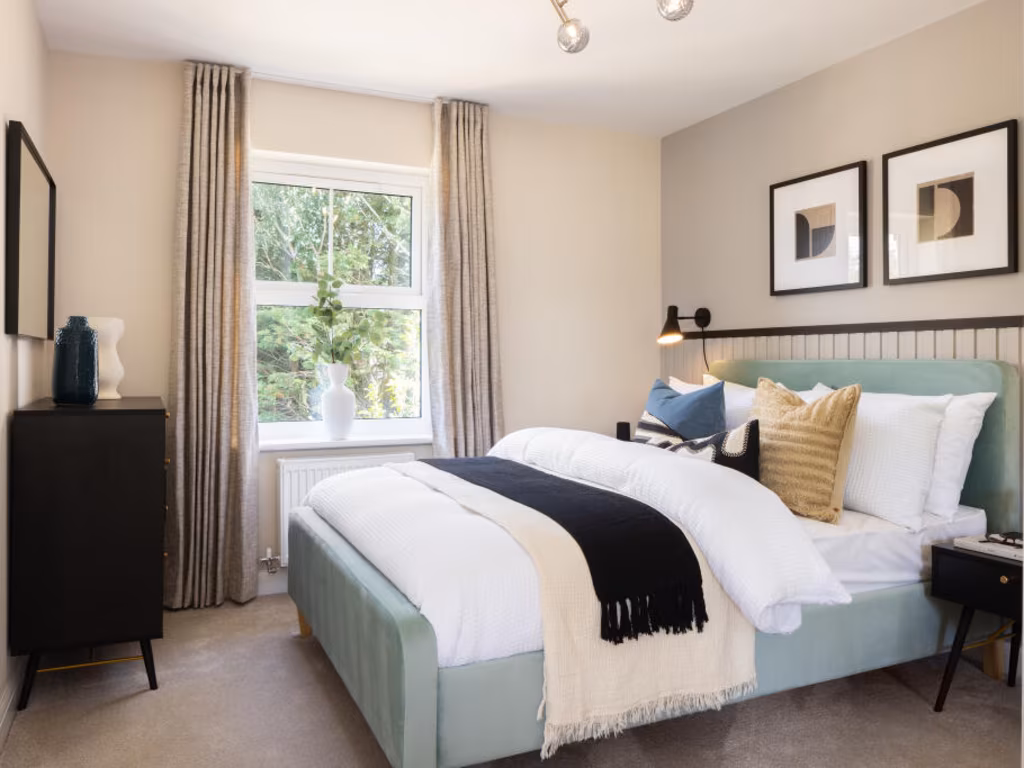
- BEDROOM 2:
Textual Property Features
Detected Visual Features
- contemporary kitchen
- open plan
- modern appliances
- neutral decor
- natural light
- recently updated
- utility room
- contemporary style
- new appliances
- wooden flooring
- neutral colors
- modern cabinetry
- clean
- small room
- laundry area
Nearby Schools
- Abbas and Templecombe Church School
- Sturminster Newton High School
- Milborne Port Primary School
- St Mary's Catholic Primary School, Marnhull
- Horsington Church School
- William Barnes Primary School
- Stower Provost Community School
- All Saints Church of England Voluntary Controlled Primary School
- Stalbridge Church of England Primary School
Nearest Bars And Restaurants
- Id: 504018534
- Tags:
- Amenity: fast_food
- Cuisine: chinese
- TagsNormalized:
- Lat: 50.9592972
- Lon: -2.3784422
- FullGeoHash: gcn3cuu56m8b
- PartitionGeoHash: gcn3
- Images:
- FoodStandards: null
- Distance: 592.9
,- Id: 5277755885
- Tags:
- TagsNormalized:
- Lat: 50.9593488
- Lon: -2.3782473
- FullGeoHash: gcn3cuu5wz4k
- PartitionGeoHash: gcn3
- Images:
- FoodStandards: null
- Distance: 586.4
,- Id: 504018533
- Tags:
- Amenity: fast_food
- Cuisine: fish_and_chips
- TagsNormalized:
- Lat: 50.9593559
- Lon: -2.3781715
- FullGeoHash: gcn3cuu7b86y
- PartitionGeoHash: gcn3
- Images:
- FoodStandards: null
- Distance: 582.9
,- Id: 501567516
- Tags:
- TagsNormalized:
- Lat: 50.9586961
- Lon: -2.3786659
- FullGeoHash: gcn3cuezvj6n
- PartitionGeoHash: gcn3
- Images:
- FoodStandards: null
- Distance: 564.8
,- Id: 544636049
- Tags:
- Addr:
- City: Stalbridge
- Postcode: DT10 2NF
- Amenity: pub
- Building: yes
- Name: The Stalbridge Arms
- TagsNormalized:
- Lat: 50.9567006
- Lon: -2.3754336
- FullGeoHash: gcn3cuqk23kr
- PartitionGeoHash: gcn3
- Images:
- FoodStandards: null
- Distance: 259.1
}
Nearest General Shops
- Id: 293687187
- Tags:
- Addr:
- Postcode: DT10 2LH
- Street: High Street
- Fhrs:
- Name: Roger Else
- Shop: butcher
- Source:
- TagsNormalized:
- Lat: 50.9595229
- Lon: -2.3785617
- FullGeoHash: gcn3cuguxrxf
- PartitionGeoHash: gcn3
- Images:
- FoodStandards:
- Id: 993980
- FHRSID: 993980
- LocalAuthorityBusinessID: 445
- BusinessName: Else Butchers Ltd
- BusinessType: Retailers - other
- BusinessTypeID: 4613
- AddressLine1: Else Butchers Ltd High Street
- AddressLine2: null
- AddressLine3: Stalbridge
- AddressLine4: Dorset
- PostCode: DT10 2LH
- RatingValue: 5
- RatingKey: fhrs_5_en-GB
- RatingDate: 2022-11-30
- LocalAuthorityCode: 085
- LocalAuthorityName: Dorset
- LocalAuthorityWebSite: https://www.dorsetcouncil.gov.uk/
- LocalAuthorityEmailAddress: envhealthteamb@dorsetcouncil.gov.uk
- Scores:
- Hygiene: 0
- Structural: 5
- ConfidenceInManagement: 5
- NewRatingPending: false
- Geocode:
- Longitude: -2.37874889373779
- Latitude: 50.96002578735350
- Distance: 615.7
,- Id: 506710767
- Tags:
- TagsNormalized:
- Lat: 50.9601904
- Lon: -2.3770524
- FullGeoHash: gcn3cvj0dsj2
- PartitionGeoHash: gcn3
- Images:
- FoodStandards: null
- Distance: 599.4
,- Id: 204959988
- Tags:
- Addr:
- Postcode: DT10 2NB
- Street: Ring Street
- Building: yes
- Fhrs:
- Name: Dike & Son
- Shop: supermarket
- TagsNormalized:
- Lat: 50.9586372
- Lon: -2.3788222
- FullGeoHash: gcn3cuez96mx
- PartitionGeoHash: gcn3
- Images:
- FoodStandards:
- Id: 993697
- FHRSID: 993697
- LocalAuthorityBusinessID: 134
- BusinessName: Dike and Son Limited
- BusinessType: Retailers - supermarkets/hypermarkets
- BusinessTypeID: 7840
- AddressLine1: Dike And Son Ltd Ring Street
- AddressLine2: null
- AddressLine3: Stalbridge
- AddressLine4: Dorset
- PostCode: DT10 2NB
- RatingValue: 5
- RatingKey: fhrs_5_en-GB
- RatingDate: 2021-09-17
- LocalAuthorityCode: 085
- LocalAuthorityName: Dorset
- LocalAuthorityWebSite: https://www.dorsetcouncil.gov.uk/
- LocalAuthorityEmailAddress: envhealthteamb@dorsetcouncil.gov.uk
- Scores:
- Hygiene: 0
- Structural: 0
- ConfidenceInManagement: 0
- NewRatingPending: false
- Geocode:
- Longitude: -2.37871003150940
- Latitude: 50.95872116088870
- Distance: 570.3
}
Nearest Grocery shops
- Id: 296573162
- Tags:
- Addr:
- Postcode: DT10 1PH
- Street: Burton Street
- Fhrs:
- Name: Robin Hill Stores
- Shop: convenience
- Source:
- TagsNormalized:
- Lat: 50.9735753
- Lon: -2.322766
- FullGeoHash: gcn3gpkweehh
- PartitionGeoHash: gcn3
- Images:
- FoodStandards: null
- Distance: 3971.6
,- Id: 2100436750
- Tags:
- Addr:
- Housename: Marnhull Stores
- Postcode: DT10 1PX
- Street: New Street
- Alt_name: Spar Stores
- Fhrs:
- Name: Marnhull Stores
- Shop: convenience
- Source: survey
- TagsNormalized:
- Lat: 50.9653234
- Lon: -2.3196403
- FullGeoHash: gcn3gjyys2yu
- PartitionGeoHash: gcn3
- Images:
- FoodStandards: null
- Distance: 3815.3
,- Id: 204955006
- Tags:
- Addr:
- Building: yes
- Name: Late Stop
- Shop: convenience
- TagsNormalized:
- Lat: 50.9769489
- Lon: -2.3942501
- FullGeoHash: gcn6180d3bj8
- PartitionGeoHash: gcn6
- Images:
- FoodStandards: null
- Distance: 2817.3
}
Nearest Religious buildings
- Id: 204953481
- Tags:
- Amenity: place_of_worship
- Denomination: anglican
- Name: St Nicholas
- Religion: christian
- Wikidata: Q17554916
- Wikipedia: en:Church of St Nicholas, Henstridge
- TagsNormalized:
- place of worship
- anglican
- christian
- church
- Lat: 50.9765987
- Lon: -2.3962243
- FullGeoHash: gcn612p05ytx
- PartitionGeoHash: gcn6
- Images:
- FoodStandards: null
- Distance: 2864.6
,- Id: 85942775
- Tags:
- Amenity: place_of_worship
- Building: church
- Denomination: anglican
- Name: St Mary
- Religion: christian
- Wikidata: Q17538965
- TagsNormalized:
- place of worship
- church
- anglican
- christian
- Lat: 50.9625274
- Lon: -2.3808857
- FullGeoHash: gcn3cv6q1rdv
- PartitionGeoHash: gcn3
- Images:
- FoodStandards: null
- Distance: 969.7
,- Id: 405364302
- Tags:
- Addr:
- Postcode: DT10 2LP
- Street: Duck Lane
- Amenity: school
- Denomination: anglican
- Diocese: Diocese of Salisbury
- Fhrs:
- Isced:
- Max_age: 11
- Min_age: 4
- Name: Stalbridge Church of England Primary School
- Phone: +44 1963362487
- Ref:
- Religion: christian
- School:
- Source:
- Website: https://www.stalbridge.dorset.sch.uk/
- TagsNormalized:
- school
- anglican
- church
- christian
- Lat: 50.9619098
- Lon: -2.3772153
- FullGeoHash: gcn3cvkfwuec
- PartitionGeoHash: gcn3
- Images:
- FoodStandards:
- Id: 994436
- FHRSID: 994436
- LocalAuthorityBusinessID: 999
- BusinessName: Local Food Links (Stalbridge Primary)
- BusinessType: School/college/university
- BusinessTypeID: 7845
- AddressLine1: Stalbridge C Of E Primary School Duck Lane
- AddressLine2: null
- AddressLine3: Stalbridge
- AddressLine4: Dorset
- PostCode: DT10 2LP
- RatingValue: 5
- RatingKey: fhrs_5_en-GB
- RatingDate: 2022-01-26
- LocalAuthorityCode: 085
- LocalAuthorityName: Dorset
- LocalAuthorityWebSite: https://www.dorsetcouncil.gov.uk/
- LocalAuthorityEmailAddress: envhealthteamb@dorsetcouncil.gov.uk
- Scores:
- Hygiene: 0
- Structural: 0
- ConfidenceInManagement: 0
- NewRatingPending: false
- Geocode:
- Longitude: -2.37753295898438
- Latitude: 50.96112060546880
- Distance: 767.4
}
Nearest Airports
- Id: 386864426
- Tags:
- Aerodrome: international
- Aeroway: aerodrome
- Alt_name: Bournemouth International Airport
- Ele: 12
- Iata: BOH
- Icao: EGHH
- Int_name: B
- Name: Bournemouth Airport
- Old_name: Hurn Airport
- Ref: EGHH
- Source: wikipedia
- Wikidata: Q580409
- Wikipedia: en:Bournemouth Airport
- TagsNormalized:
- airport
- international airport
- Lat: 50.7825186
- Lon: -1.84232
- FullGeoHash: gcn8yhdmwgde
- PartitionGeoHash: gcn8
- Images:
- FoodStandards: null
- Distance: 41868.9
}
Nearest Leisure Facilities
- Id: 224330877
- Tags:
- Leisure: park
- Name: Stalbridge Recreation Area Play Park
- TagsNormalized:
- Lat: 50.9571736
- Lon: -2.3849772
- FullGeoHash: gcn3csrr418h
- PartitionGeoHash: gcn3
- Images:
- FoodStandards: null
- Distance: 921.3
,- Id: 544429938
- Tags:
- Leisure: pitch
- Sport: soccer
- TagsNormalized:
- Lat: 50.9622085
- Lon: -2.3763766
- FullGeoHash: gcn3cvms6kjp
- PartitionGeoHash: gcn3
- Images:
- FoodStandards: null
- Distance: 771.6
,- Id: 85642362
- Tags:
- TagsNormalized:
- swimming
- swimming pool
- pool
- leisure
- Lat: 50.9616795
- Lon: -2.3778956
- FullGeoHash: gcn3cvk3r18e
- PartitionGeoHash: gcn3
- Images:
- FoodStandards: null
- Distance: 769.5
,- Id: 544429937
- Tags:
- Access: private
- Leisure: playground
- TagsNormalized:
- Lat: 50.9616782
- Lon: -2.3774621
- FullGeoHash: gcn3cvkc317g
- PartitionGeoHash: gcn3
- Images:
- FoodStandards: null
- Distance: 753.5
,- Id: 973160628
- Tags:
- TagsNormalized:
- Lat: 50.9585326
- Lon: -2.3704154
- FullGeoHash: gcn3fh9yvqfp
- PartitionGeoHash: gcn3
- Images:
- FoodStandards: null
- Distance: 319
}
Nearest Tourist attractions
- Id: 3992493126
- Tags:
- Name: Woodlands Farm Bed and Breakfast
- Tourism: guest_house
- TagsNormalized:
- bed
- farm
- guest house
- tourism
- Lat: 50.9222256
- Lon: -2.3357942
- FullGeoHash: gcn3dy55knce
- PartitionGeoHash: gcn3
- Images:
- FoodStandards: null
- Distance: 4517.4
,- Id: 2463268049
- Tags:
- Name: Blackmore Farmhouse Cottage B&B
- Tourism: guest_house
- TagsNormalized:
- Lat: 50.9219324
- Lon: -2.3656801
- FullGeoHash: gcn3dnj3g8jn
- PartitionGeoHash: gcn3
- Images:
- FoodStandards: null
- Distance: 3796.5
,- Id: 413719705
- Tags:
- TagsNormalized:
- Lat: 50.9840022
- Lon: -2.3673446
- FullGeoHash: gcn641k5kfgg
- PartitionGeoHash: gcn6
- Images:
- FoodStandards: null
- Distance: 3148.1
}
Nearest Train stations
- Id: 6011304342
- Tags:
- Name: Gillingham
- Naptan:
- Network: National Rail
- Public_transport: station
- Railway: station
- Ref:
- Wheelchair: yes
- Wikidata: Q2731470
- Wikipedia: en:Gillingham railway station (Dorset)
- TagsNormalized:
- Lat: 51.0340876
- Lon: -2.2720765
- FullGeoHash: gcn6k63x0g2y
- PartitionGeoHash: gcn6
- Images:
- FoodStandards: null
- Distance: 11162.3
,- Id: 6013523221
- Tags:
- Name: Sherborne
- Naptan:
- Network: National Rail
- Public_transport: station
- Railway: station
- Ref:
- Source: gps_survey
- Wikidata: Q2407888
- Wikipedia: en:Sherborne railway station
- TagsNormalized:
- Lat: 50.943979
- Lon: -2.5129696
- FullGeoHash: gcn1yf445tfp
- PartitionGeoHash: gcn1
- Images:
- FoodStandards: null
- Distance: 9963.4
,- Id: 6011304340
- Tags:
- Name: Templecombe
- Naptan:
- Network: National Rail
- Public_transport: station
- Railway: station
- Ref:
- Wikidata: Q1901020
- Wikipedia: en:Templecombe railway station
- TagsNormalized:
- Lat: 51.001594
- Lon: -2.4172852
- FullGeoHash: gcn60uxcc4jw
- PartitionGeoHash: gcn6
- Images:
- FoodStandards: null
- Distance: 5994.6
,- Id: 9991604554
- Tags:
- Name: Common Lane
- Network: Gartell Light Railway
- Operator: Gartell Light Railway
- Public_transport: station
- Railway: station
- Train: yes
- Usage: tourism
- TagsNormalized:
- Lat: 50.9949551
- Lon: -2.4024297
- FullGeoHash: gcn6176e5kds
- PartitionGeoHash: gcn6
- Images:
- FoodStandards: null
- Distance: 4843.1
,- Id: 9991604612
- Tags:
- Name: Pinesway Junction
- Public_transport: station
- Railway: station
- Train: yes
- Usage: tourism
- TagsNormalized:
- Lat: 50.9936437
- Lon: -2.4036374
- FullGeoHash: gcn6171ex0nj
- PartitionGeoHash: gcn6
- Images:
- FoodStandards: null
- Distance: 4751.5
}
Nearest Bus stations and stops
- Id: 4885531824
- Tags:
- Bus: yes
- Highway: bus_stop
- Public_transport: platform
- TagsNormalized:
- Lat: 50.9267203
- Lon: -2.3033242
- FullGeoHash: gcn3ewfv8ssz
- PartitionGeoHash: gcn3
- Images:
- FoodStandards: null
- Distance: 5799.7
,- Id: 4885531823
- Tags:
- Bus: yes
- Highway: bus_stop
- Public_transport: platform
- TagsNormalized:
- Lat: 50.9270061
- Lon: -2.3040212
- FullGeoHash: gcn3ewfr26j2
- PartitionGeoHash: gcn3
- Images:
- FoodStandards: null
- Distance: 5741.4
,- Id: 4868308431
- Tags:
- Bus: yes
- Highway: bus_stop
- Public_transport: platform
- TagsNormalized:
- Lat: 50.9331769
- Lon: -2.3051096
- FullGeoHash: gcn3g817r03d
- PartitionGeoHash: gcn3
- Images:
- FoodStandards: null
- Distance: 5320.8
,- Id: 9325317281
- Tags:
- Bus: yes
- Highway: bus_stop
- Public_transport: platform
- Shelter: no
- Source: survey
- TagsNormalized:
- Lat: 50.9222193
- Lon: -2.3632639
- FullGeoHash: gcn3dnp57vww
- PartitionGeoHash: gcn3
- Images:
- FoodStandards: null
- Distance: 3788.4
,- Id: 296573856
- Tags:
- Bus: yes
- Highway: bus_stop
- Public_transport: platform
- TagsNormalized:
- Lat: 50.9797401
- Lon: -2.3984348
- FullGeoHash: gcn612td82m7
- PartitionGeoHash: gcn6
- Images:
- FoodStandards: null
- Distance: 3238.7
}
Nearest Hotels
- Id: 2424818415
- Tags:
- Brand: Travelodge
- Brand:wikidata: Q9361374
- Brand:wikipedia: en:Travelodge UK
- Name: Travelodge
- Tourism: hotel
- TagsNormalized:
- Lat: 51.0492457
- Lon: -2.4192457
- FullGeoHash: gcn62vnr7mps
- PartitionGeoHash: gcn6
- Images:
- FoodStandards: null
- Distance: 10899.6
,- Id: 2125405901
- Tags:
- Name: The Eastbury
- Tourism: hotel
- Wikidata: Q26610005
- TagsNormalized:
- Lat: 50.9479446
- Lon: -2.5109557
- FullGeoHash: gcn1yfg963px
- PartitionGeoHash: gcn1
- Images:
- FoodStandards: null
- Distance: 9773.7
,- Id: 2396549477
- Tags:
- Name: The Kings Arms
- Tourism: hotel
- TagsNormalized:
- Lat: 51.0073071
- Lon: -2.4793351
- FullGeoHash: gcn4ptde571y
- PartitionGeoHash: gcn4
- Images:
- FoodStandards: null
- Distance: 9445.3
}
Tags
- contemporary kitchen
- open plan
- modern appliances
- neutral decor
- natural light
- recently updated
- utility room
- contemporary style
- new appliances
- wooden flooring
- neutral colors
- modern cabinetry
- clean
- small room
- laundry area
Local Market Stats
- Average Price/sqft: £304
- Avg Income: £45800
- Social Housing: 7%
- Planning Success Rate: 86%
Similar Properties
 3 bedroom semi-detached house for sale in Lower Road,
Stalbridge,
Sturminster Newton,
Dorset,
DT10 2PQ, DT10 — £330,000 • 3 bed • 1 bath • 810 ft²
3 bedroom semi-detached house for sale in Lower Road,
Stalbridge,
Sturminster Newton,
Dorset,
DT10 2PQ, DT10 — £330,000 • 3 bed • 1 bath • 810 ft²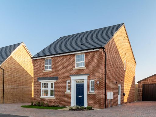 4 bedroom detached house for sale in Lower Road,
Stalbridge,
Sturminster Newton,
Dorset,
DT10 2PQ, DT10 — £450,000 • 4 bed • 1 bath • 1174 ft²
4 bedroom detached house for sale in Lower Road,
Stalbridge,
Sturminster Newton,
Dorset,
DT10 2PQ, DT10 — £450,000 • 4 bed • 1 bath • 1174 ft²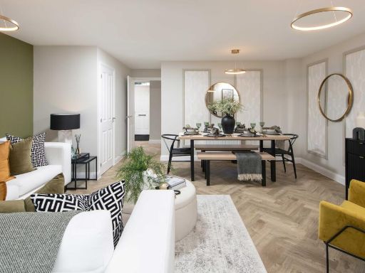 3 bedroom semi-detached house for sale in Lower Road,
Stalbridge,
Sturminster Newton,
Dorset,
DT10 2PQ, DT10 — £325,000 • 3 bed • 1 bath • 756 ft²
3 bedroom semi-detached house for sale in Lower Road,
Stalbridge,
Sturminster Newton,
Dorset,
DT10 2PQ, DT10 — £325,000 • 3 bed • 1 bath • 756 ft² 3 bedroom end of terrace house for sale in Lower Road,
Stalbridge,
Sturminster Newton,
Dorset,
DT10 2PQ, DT10 — £318,500 • 3 bed • 1 bath • 756 ft²
3 bedroom end of terrace house for sale in Lower Road,
Stalbridge,
Sturminster Newton,
Dorset,
DT10 2PQ, DT10 — £318,500 • 3 bed • 1 bath • 756 ft² 2 bedroom semi-detached house for sale in Lower Road,
Stalbridge,
Sturminster Newton,
Dorset,
DT10 2PQ, DT10 — £267,500 • 2 bed • 1 bath • 506 ft²
2 bedroom semi-detached house for sale in Lower Road,
Stalbridge,
Sturminster Newton,
Dorset,
DT10 2PQ, DT10 — £267,500 • 2 bed • 1 bath • 506 ft² 4 bedroom detached house for sale in Lower Road,
Stalbridge,
Sturminster Newton,
Dorset,
DT10 2PQ, DT10 — £480,000 • 4 bed • 1 bath • 1216 ft²
4 bedroom detached house for sale in Lower Road,
Stalbridge,
Sturminster Newton,
Dorset,
DT10 2PQ, DT10 — £480,000 • 4 bed • 1 bath • 1216 ft²
Meta
- {
"@context": "https://schema.org",
"@type": "Residence",
"name": "3 bedroom semidetached house for sale in Lower Road, Stalbr…",
"description": "",
"url": "https://propertypiper.co.uk/property/742904af-60be-4f70-96fa-a337d7e7f6d0",
"image": "https://image-a.propertypiper.co.uk/a3a4e8ca-2998-4b87-ad92-e22afb1e8742-1024.jpeg",
"address": {
"@type": "PostalAddress",
"streetAddress": "Lower Road, \r\nStalbridge, \r\nSturminster Newton, \r\nDorset, \r\nDT10 2PQ",
"postalCode": "DT10 2PQ",
"addressLocality": "Dorset",
"addressRegion": "North Dorset",
"addressCountry": "England"
},
"geo": {
"@type": "GeoCoordinates",
"latitude": 50.9558422,
"longitude": -2.3719946
},
"numberOfRooms": 3,
"numberOfBathroomsTotal": 1,
"floorSize": {
"@type": "QuantitativeValue",
"value": 810,
"unitCode": "FTK"
},
"offers": {
"@type": "Offer",
"price": 335000,
"priceCurrency": "GBP",
"availability": "https://schema.org/InStock"
},
"additionalProperty": [
{
"@type": "PropertyValue",
"name": "Feature",
"value": "contemporary kitchen"
},
{
"@type": "PropertyValue",
"name": "Feature",
"value": "open plan"
},
{
"@type": "PropertyValue",
"name": "Feature",
"value": "modern appliances"
},
{
"@type": "PropertyValue",
"name": "Feature",
"value": "neutral decor"
},
{
"@type": "PropertyValue",
"name": "Feature",
"value": "natural light"
},
{
"@type": "PropertyValue",
"name": "Feature",
"value": "recently updated"
},
{
"@type": "PropertyValue",
"name": "Feature",
"value": "utility room"
},
{
"@type": "PropertyValue",
"name": "Feature",
"value": "contemporary style"
},
{
"@type": "PropertyValue",
"name": "Feature",
"value": "new appliances"
},
{
"@type": "PropertyValue",
"name": "Feature",
"value": "wooden flooring"
},
{
"@type": "PropertyValue",
"name": "Feature",
"value": "neutral colors"
},
{
"@type": "PropertyValue",
"name": "Feature",
"value": "modern cabinetry"
},
{
"@type": "PropertyValue",
"name": "Feature",
"value": "clean"
},
{
"@type": "PropertyValue",
"name": "Feature",
"value": "small room"
},
{
"@type": "PropertyValue",
"name": "Feature",
"value": "laundry area"
}
]
}
High Res Floorplan Images
Compatible Floorplan Images
FloorplanImages Thumbnail