SP11 8BE - Land for sale in Amport, Andover, Hampshire, SP11
View on Property Piper
Land for sale in Amport, Andover, Hampshire, SP11
Property Details
- Price: £1500000
- Bedrooms: 3
- Bathrooms: 1
- Property Type: undefined
- Property SubType: undefined
Brochure Descriptions
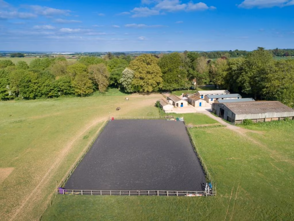
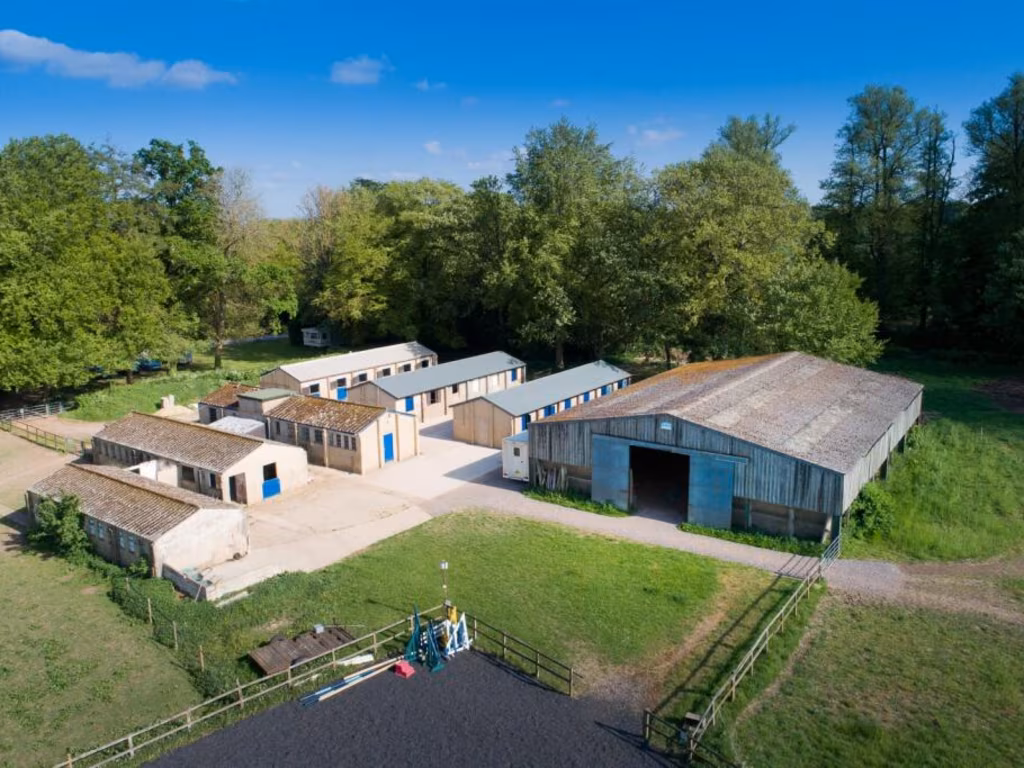
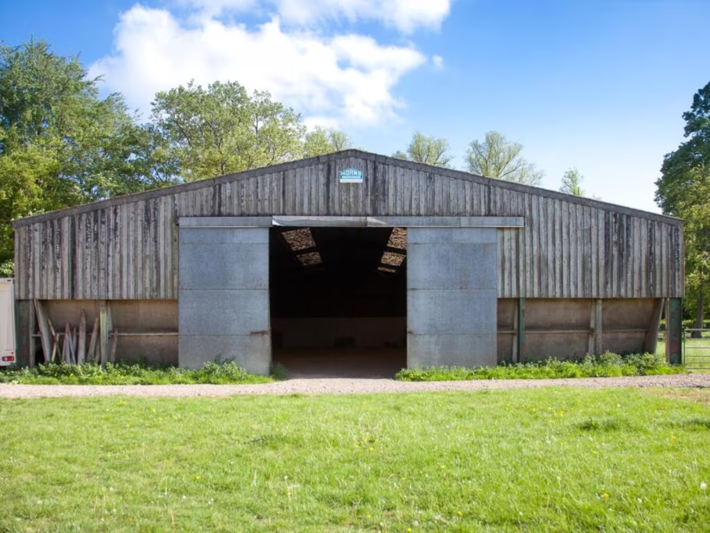
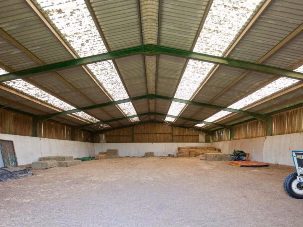
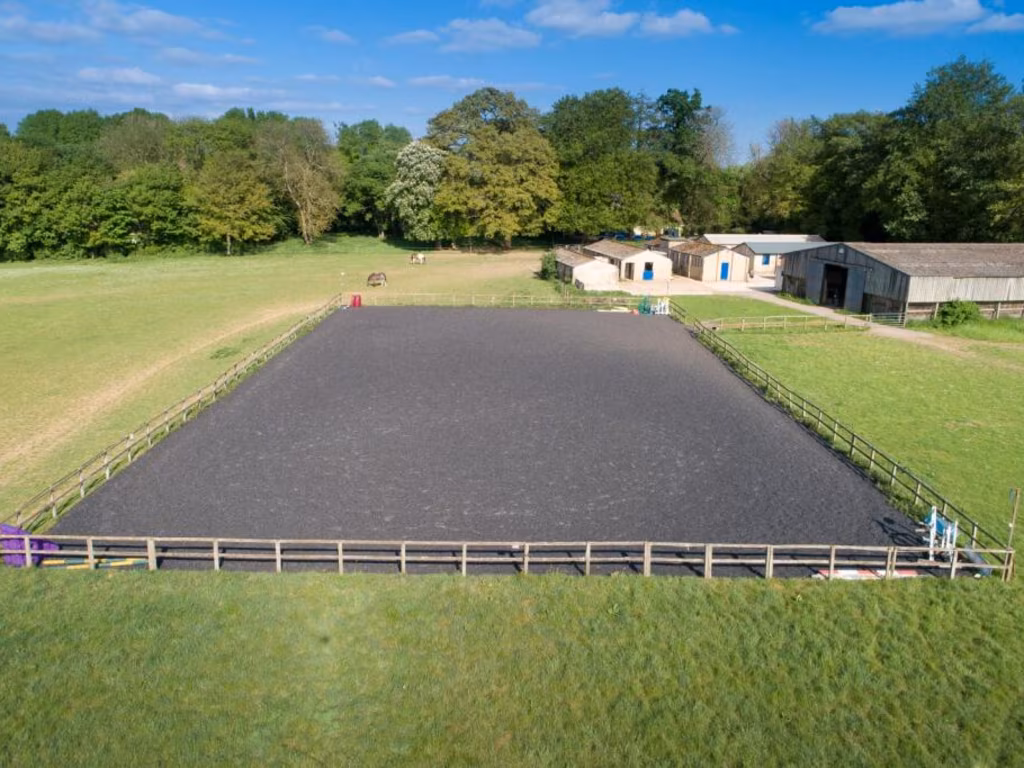
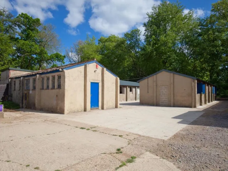
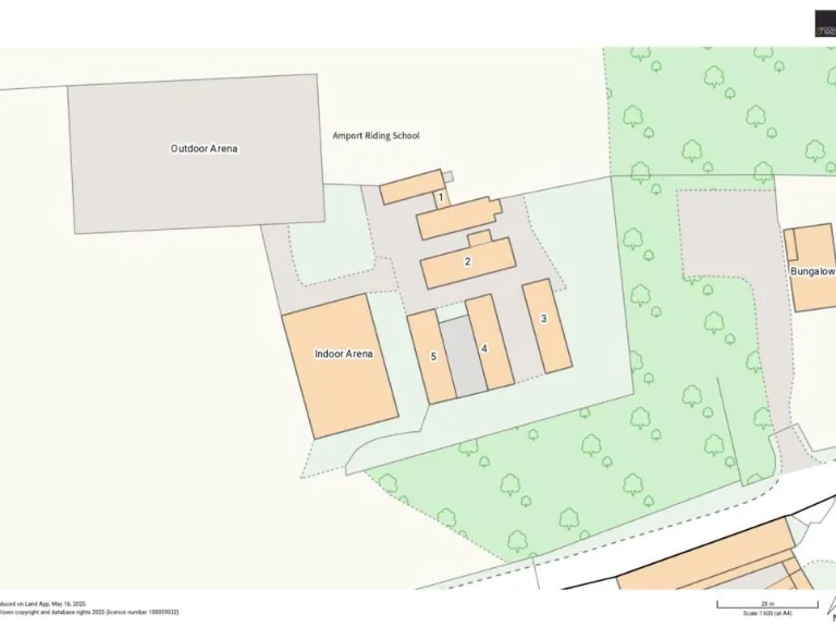
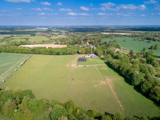
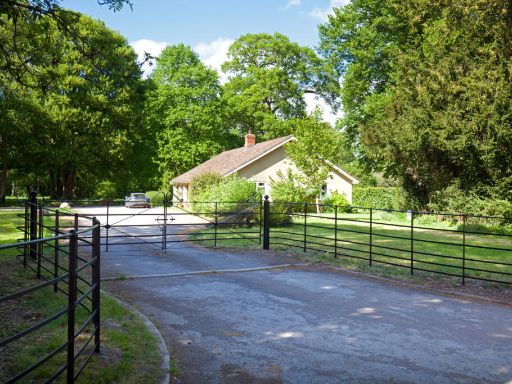
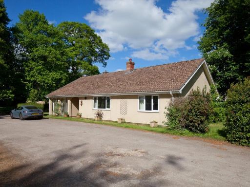
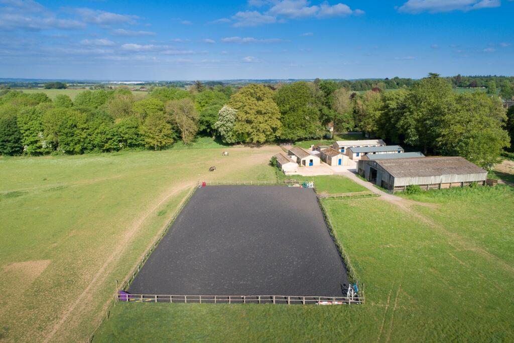
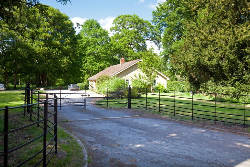
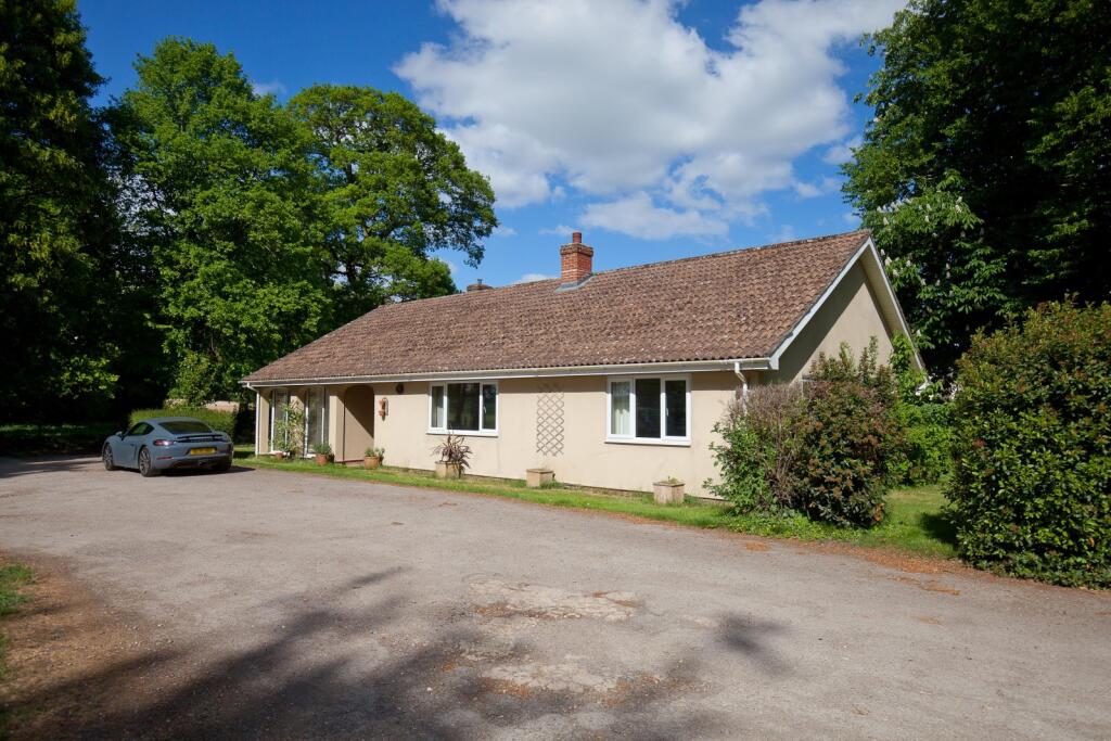
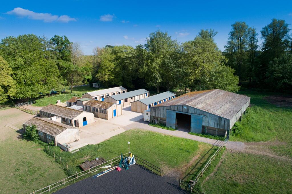
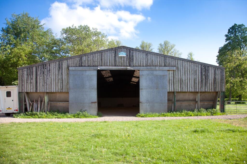
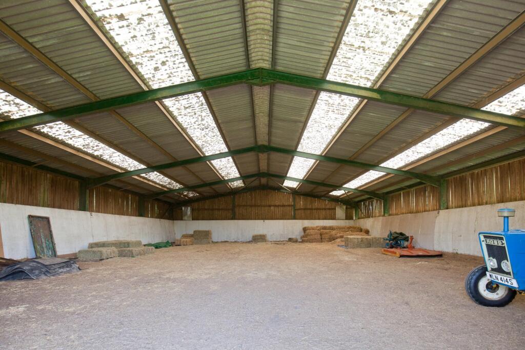
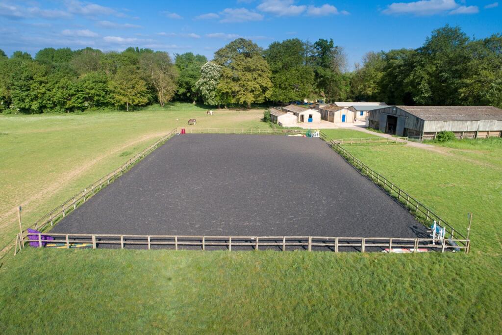
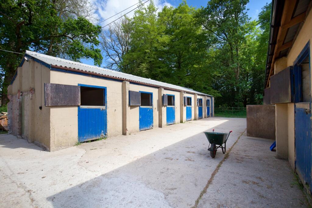
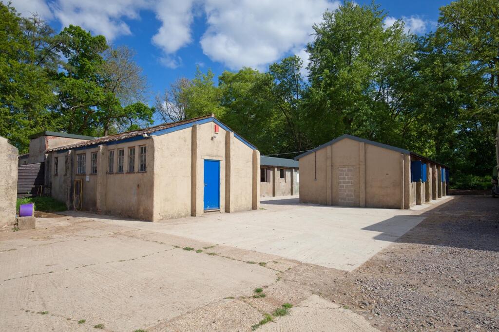
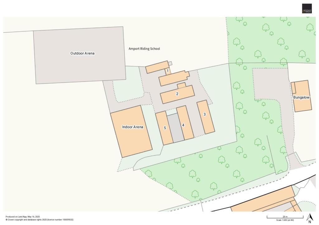
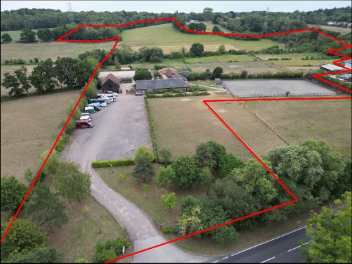
- Amport Riding Centre is an expansive equestrian property situated in the picturesque countryside of Hampshire. The center features large outdoor riding arenas, multiple stable blocks, and ample paddock space suitable for horse training and recreation. Surrounded by lush forests, the property offers tranquil views conducive to peaceful riding experiences. The spaces are designed to accommodate equestrian needs, with significant grounds allowing for further development or activities related to horse care and management.
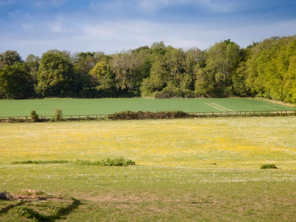
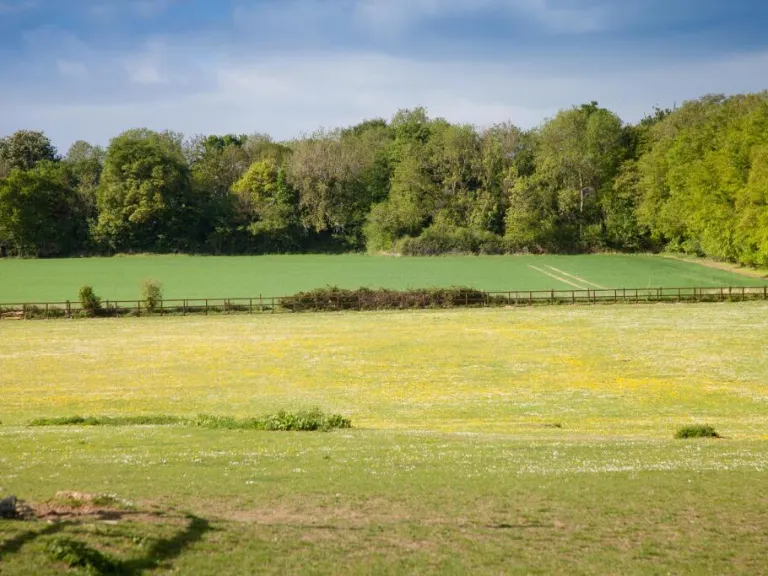
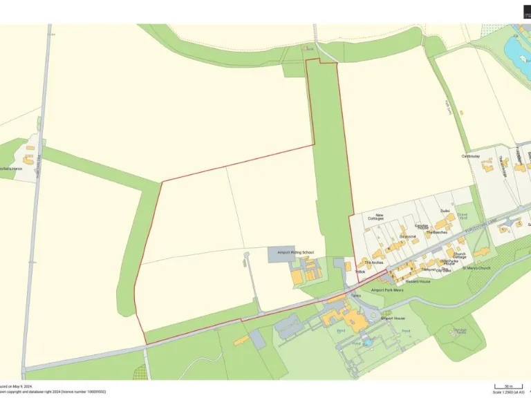
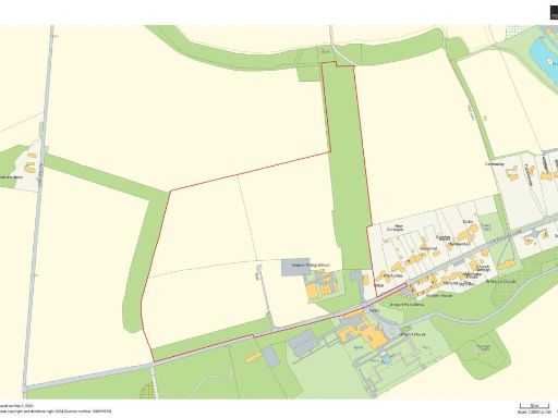
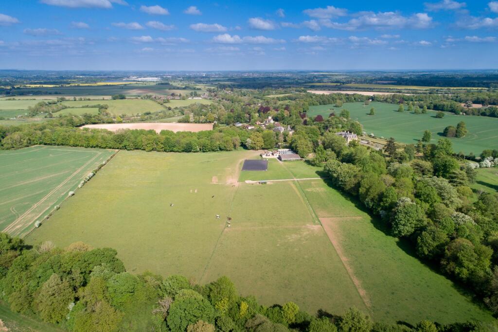
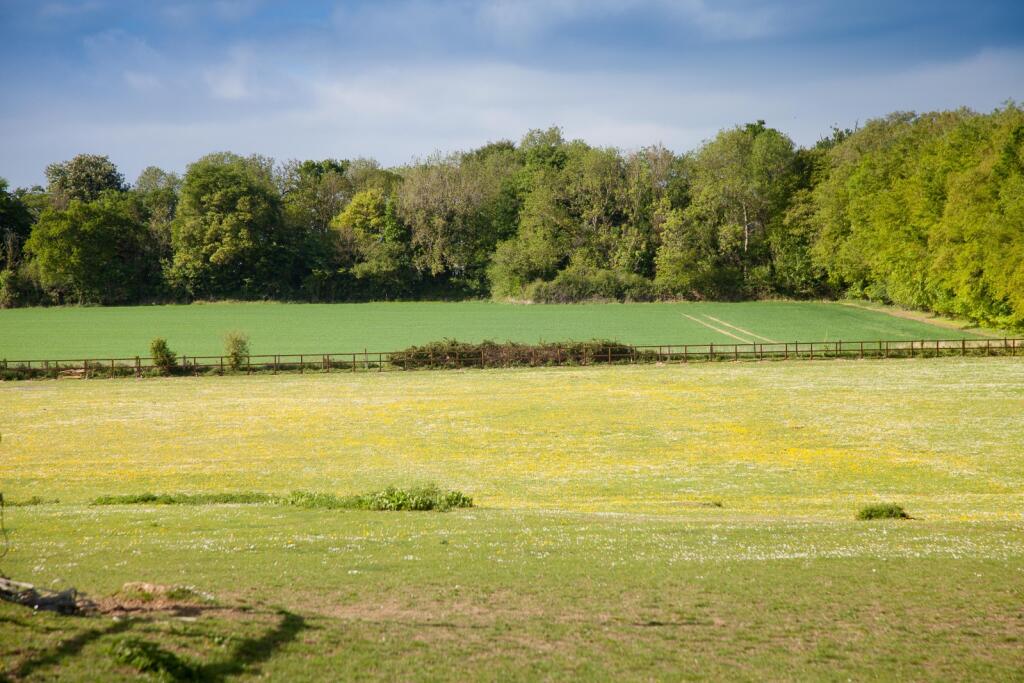
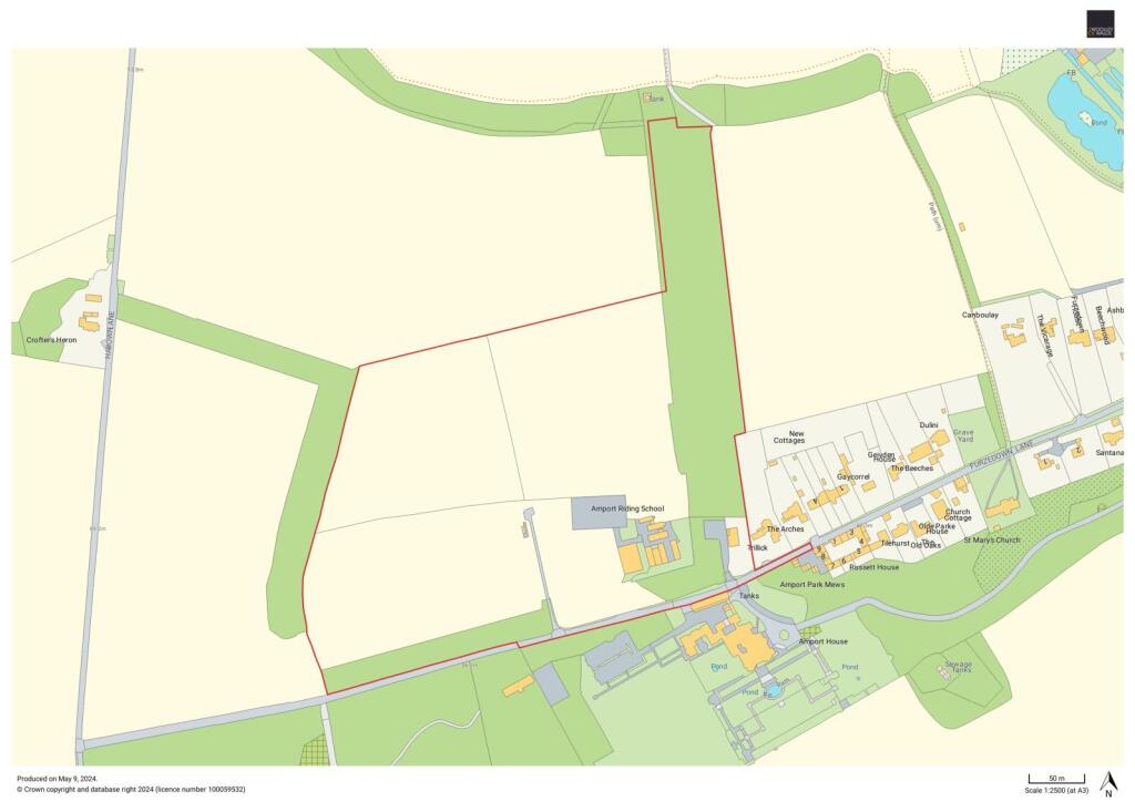
- The property is a large open expanse of verdant countryside, featuring expansive fields ideal for agricultural or equestrian use. The property is bordered by a dense tree line, suggesting privacy and seclusion. To one side, there appears to be a small complex of buildings, potentially serving as storage or facilities related to the property's use. The view offers an uninterrupted panorama of rolling hills and farmlands, contributing to a serene and pastoral setting. The overall size of the property is impressively large, likely encompassing several acres.
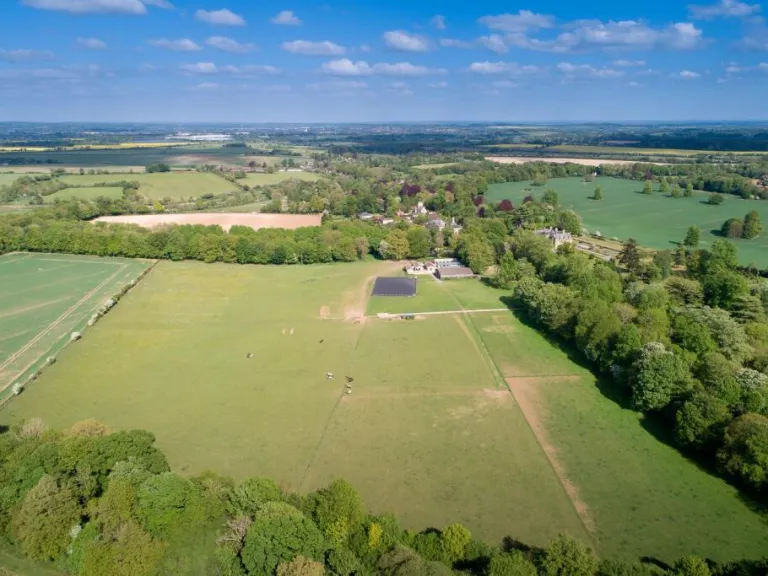
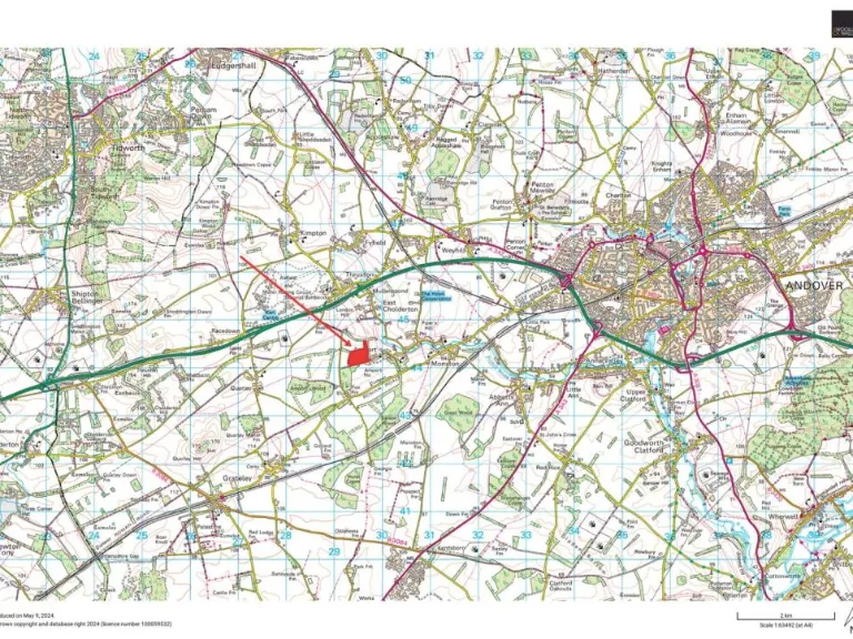
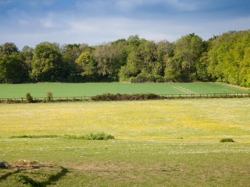
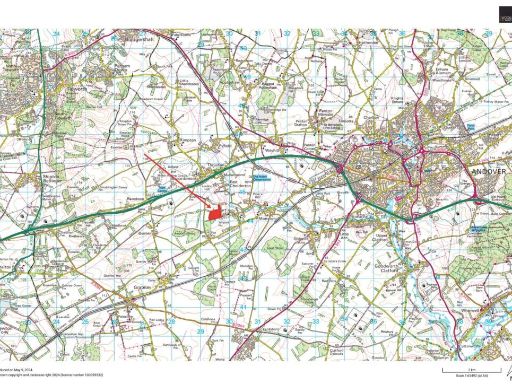
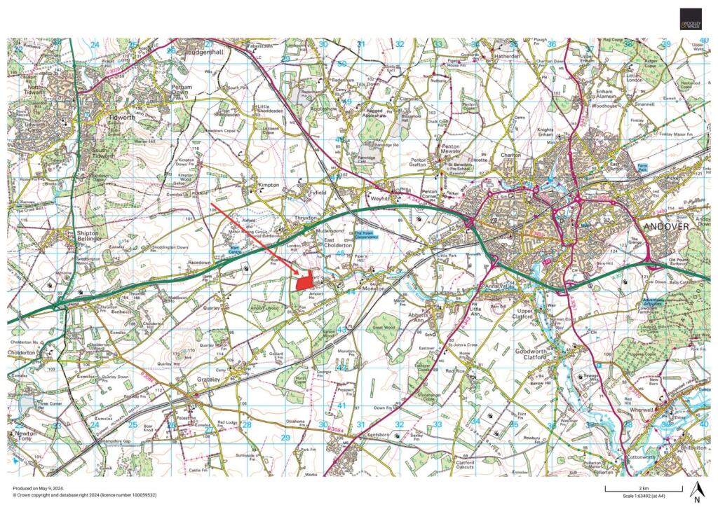
- This property is set in an expansive rural landscape, offering vast open fields and picturesque views that stretch to the horizon. The location appears isolated and serene, surrounded by dense woodlands, providing a natural barrier and offering an exceptional degree of privacy. The size of the land is huge, suitable for agricultural use or equestrian purposes, and includes areas that can be developed into gardens or recreational spaces. The overall setting provides sweeping views of the countryside, making it an ideal retreat for those who value tranquility and nature.
Image Descriptions
- equestrian facility agricultural
- large rural estate estate
Textual Property Features
Detected Visual Features
- equestrian
- agricultural
- stable
- paddock
- arena
- rural
- countryside
- spacious
- land
- recreational
- estate
- acreage
- agriculture
- open fields
EPC Details
- Fully double glazed
- Cavity wall, as built, insulated (assumed)
- Boiler and radiators, oil
- Low energy lighting in all fixed outlets
- Solid, no insulation (assumed)
Nearby Schools
- Anton Junior School
- Balksbury Junior School
- Shipton Bellinger Primary School
- Knights Enham Nursery and Infant School
- Knight's Enham Junior School
- Wallop Primary School
- Farleigh School
- John Hanson Community School
- Rookwood School
- Andover Church of England Primary School
- Portway Junior School
- Harrow Way Community School
- Wellington Lions Primary Academy
- The Wellington Academy
- Ludgershall Castle Primary School
- Clatford Church of England Primary School
- Anton Infant School
- Balksbury Infant School
- Clarendon Infants' School
- Clarendon Junior School (Clarendon Federation)
- Appleshaw St Peter's CofE Primary School
- Grateley Primary School
- Abbotts Ann Church of England Primary School
- Amport Church of England Primary School
- St John the Baptist Catholic Primary School, Andover
- Portway Infant School
- Kimpton, Thruxton and Fyfield Church of England Primary School
- Wellington Eagles Primary Academy
Nearest Bars And Restaurants
- Id: 226560768
- Tags:
- Addr:
- Postcode: SP11 8JR
- Street: Chapel Lane
- Amenity: pub
- Building: yes
- Name: The Plough Inn
- Website: http://www.ploughinngrateley.co.uk/
- TagsNormalized:
- Lat: 51.1758937
- Lon: -1.6026603
- FullGeoHash: gcng5s2cpq1b
- PartitionGeoHash: gcng
- Images:
- FoodStandards: null
- Distance: 2847.2
,- Id: 5882180102
- Tags:
- Amenity: restaurant
- Cuisine: regional
- Name: Thruxton Centre
- TagsNormalized:
- Lat: 51.2090445
- Lon: -1.6089681
- FullGeoHash: gcng76k6k3f3
- PartitionGeoHash: gcng
- Images:
- FoodStandards: null
- Distance: 2631.2
,- Id: 684905690
- Tags:
- Amenity: pub
- Name: Black Swan
- Odbl: clean
- Toilets:
- Wheelchair: limited
- Wikidata: Q26386243
- TagsNormalized:
- Lat: 51.1986501
- Lon: -1.5512788
- FullGeoHash: gcngk8qmu84s
- PartitionGeoHash: gcng
- Images:
- FoodStandards: null
- Distance: 1845.1
,- Id: 8231309860
- Tags:
- Amenity: restaurant
- Name: Feathers Restaurant
- TagsNormalized:
- Lat: 51.2078666
- Lon: -1.5615302
- FullGeoHash: gcngk6ngmwnw
- PartitionGeoHash: gcng
- Images:
- FoodStandards: null
- Distance: 1720.1
,- Id: 504667599
- Tags:
- Amenity: pub
- Name: Hawk Inn
- Opening_hours: Mo-Sa 12:00-23:00; Su 12:00-22:30; PH 12:00-22:30
- Opening_hours:kitchen: Mo-Fr 07:30-10:30, 12:00-14:30, 18:30-21:30; Sa 08:30-11:00, 12:00-14:30, 18:30-21:30; Su 08:30-11:00, 12:00-14:30, 18:00-21:00; PH 08:30-11:00, 12:00-14:30, 18:00-21:00
- Toilets: yes
- Toilets:wheelchair: yes
- Wheelchair: yes
- TagsNormalized:
- Lat: 51.1995046
- Lon: -1.5602147
- FullGeoHash: gcngk2xfsr7t
- PartitionGeoHash: gcng
- Images:
- FoodStandards: null
- Distance: 1260
}
Nearest General Shops
- Id: 537254788
- Tags:
- Addr:
- City: Abbotts Ann
- Postcode: SP11 7BG
- Street: Duck Street
- Amenity: post_office
- Building: yes
- Name: Abbots Ann Village Shop and Post Office
- TagsNormalized:
- Lat: 51.1905105
- Lon: -1.5310336
- FullGeoHash: gcngjnvnk6f9
- PartitionGeoHash: gcng
- Images:
- FoodStandards: null
- Distance: 3290.7
,- Id: 480033263
- Tags:
- Addr:
- City: Weyhill
- Housename: Rosebourne
- Postcode: SP11 8ED
- Street: Amesbury Road
- Building: yes
- Name: Rosebourne
- Phone: +44 1264 771 714
- Shop: garden_centre
- Toilets:
- Website: https://rosebourne.co.uk/
- Wheelchair: yes
- TagsNormalized:
- Lat: 51.2127693
- Lon: -1.5690722
- FullGeoHash: gcngk712jbnu
- PartitionGeoHash: gcng
- Images:
- FoodStandards: null
- Distance: 1950.1
,- Id: 8231309835
- Tags:
- Name: Hawk Conservancy Trust Gift Shop
- Shop: gift
- TagsNormalized:
- Lat: 51.2080031
- Lon: -1.5614582
- FullGeoHash: gcngk6nuprsk
- PartitionGeoHash: gcng
- Images:
- FoodStandards: null
- Distance: 1734.9
}
Nearest Grocery shops
- Id: 418062506
- Tags:
- Addr:
- City: Weyhill
- Postcode: SP11 0PP
- Street: Weyhill Road
- Area: yes
- Name: Weyhill Farm Shop
- Shop: convenience
- TagsNormalized:
- farm
- farm shop
- shop
- convenience
- Lat: 51.2174413
- Lon: -1.5430153
- FullGeoHash: gcngkgu7jph6
- PartitionGeoHash: gcng
- Images:
- FoodStandards: null
- Distance: 3378.6
,- Id: 418060774
- Tags:
- Addr:
- City: Weyhill
- Housename: Weyhill Service Station
- Postcode: SP11 0PH
- Street: Weyhill Road
- Area: yes
- Brand: Londis
- Brand:wikidata: Q21008564
- Name: Londis
- Shop: convenience
- TagsNormalized:
- Lat: 51.2173102
- Lon: -1.5442601
- FullGeoHash: gcngkggd2ns5
- PartitionGeoHash: gcng
- Images:
- FoodStandards: null
- Distance: 3307.2
,- Id: 226562947
- Tags:
- Addr:
- Building: yes
- Shop: convenience
- TagsNormalized:
- Lat: 51.1758917
- Lon: -1.6044957
- FullGeoHash: gcng5kr9ht9k
- PartitionGeoHash: gcng
- Images:
- FoodStandards: null
- Distance: 2928.2
}
Nearest Religious buildings
- Id: 506921111
- Tags:
- Amenity: place_of_worship
- Building: church
- Denomination: anglican
- Name: St Peter and St Paul
- Religion: christian
- Wikidata: Q17528509
- TagsNormalized:
- place of worship
- church
- anglican
- paul
- christian
- Lat: 51.2087548
- Lon: -1.5878903
- FullGeoHash: gcng7f78x7z1
- PartitionGeoHash: gcng
- Images:
- FoodStandards: null
- Distance: 1591.6
,- Id: 280712875
- Tags:
- Addr:
- Postcode: SP11 8BA
- Street: The Green
- Amenity: school
- Capacity: 98
- Denomination: anglican
- Diocese: Diocese of Winchester
- Isced:
- Max_age: 11
- Min_age: 4
- Name: Amport Church of England Primary School
- Phone: +44 1264 772396
- Ref:
- Religion: christian
- School:
- Boarding: no
- Gender: mixed
- Selective: no
- Trust: no
- Type: voluntary_aided
- Website: https://www.amport.hants.sch.uk/
- TagsNormalized:
- school
- anglican
- church
- christian
- Lat: 51.1966902
- Lon: -1.5681759
- FullGeoHash: gcngk2446fg2
- PartitionGeoHash: gcng
- Images:
- FoodStandards: null
- Distance: 648.8
,- Id: 360731248
- Tags:
- Amenity: place_of_worship
- Building: church
- Denomination: anglican
- Name: St Mary's
- Religion: christian
- Wikidata: Q17535357
- TagsNormalized:
- place of worship
- church
- anglican
- christian
- Lat: 51.1962561
- Lon: -1.572859
- FullGeoHash: gcnghpyxv9z7
- PartitionGeoHash: gcng
- Images:
- FoodStandards: null
- Distance: 319.3
}
Nearest Medical buildings
- Id: 2443459732
- Tags:
- Amenity: pharmacy
- Brand: Boots
- Brand:wikidata: Q6123139
- Brand:wikipedia: en:Boots UK
- Healthcare: pharmacy
- Name: Boots
- Wheelchair: yes
- TagsNormalized:
- pharmacy
- boots
- health
- healthcare
- Lat: 51.2138018
- Lon: -1.4940239
- FullGeoHash: gcngq50n48x5
- PartitionGeoHash: gcng
- Images:
- FoodStandards: null
- Distance: 6137.3
,- Id: 264443678
- Tags:
- Amenity: doctors
- Building: hospital
- Name: Andover Health Centre
- Opening_hours: Mo 7:30-19:00; Tu-Fr 7:30-18:15
- Wheelchair: yes
- TagsNormalized:
- doctor
- doctors
- hospital
- health
- health centre
- Lat: 51.2150841
- Lon: -1.4954622
- FullGeoHash: gcngmgrj3pws
- PartitionGeoHash: gcng
- Images:
- FoodStandards: null
- Distance: 6090.6
,- Id: 106869277
- Tags:
- Amenity: doctors
- Building: yes
- Name: Charlton Hill Surgery
- TagsNormalized:
- Lat: 51.21604
- Lon: -1.4961691
- FullGeoHash: gcngmgwe09z6
- PartitionGeoHash: gcng
- Images:
- FoodStandards: null
- Distance: 6082.4
,- Id: 8231309870
- Tags:
- Amenity: veterinary
- Name: National Bird of Prey Hospital and Rehabilitation Unit
- TagsNormalized:
- Lat: 51.2077097
- Lon: -1.5615236
- FullGeoHash: gcngk6nftbgw
- PartitionGeoHash: gcng
- Images:
- FoodStandards: null
- Distance: 1707.1
}
Nearest Leisure Facilities
- Id: 508365245
- Tags:
- Access: yes
- Leisure: garden
- TagsNormalized:
- Lat: 51.2088239
- Lon: -1.5856812
- FullGeoHash: gcng7fm34bwm
- PartitionGeoHash: gcng
- Images:
- FoodStandards: null
- Distance: 1534.4
,- Id: 506480837
- Tags:
- Landcover: grass
- Landuse: village_green
- Leisure: park
- Name: Thruxton Village Green
- TagsNormalized:
- Lat: 51.2086965
- Lon: -1.5851391
- FullGeoHash: gcng7fm8r8ft
- PartitionGeoHash: gcng
- Images:
- FoodStandards: null
- Distance: 1507.4
,- Id: 508365250
- Tags:
- Leisure: outdoor_seating
- Operator: White Horse
- TagsNormalized:
- outdoor
- outdoor seating
- leisure
- Lat: 51.2092334
- Lon: -1.577083
- FullGeoHash: gcngk47e7kcx
- PartitionGeoHash: gcng
- Images:
- FoodStandards: null
- Distance: 1468.3
,- Id: 848556991
- Tags:
- Leisure: pitch
- Sport: cricket
- TagsNormalized:
- pitch
- leisure
- cricket
- sports
- Lat: 51.1922884
- Lon: -1.5678814
- FullGeoHash: gcnghr629wnz
- PartitionGeoHash: gcng
- Images:
- FoodStandards: null
- Distance: 784.6
,- Id: 815675291
- Tags:
- Leisure: pitch
- Sport: soccer
- TagsNormalized:
- Lat: 51.1973941
- Lon: -1.5671415
- FullGeoHash: gcngk24y6vyx
- PartitionGeoHash: gcng
- Images:
- FoodStandards: null
- Distance: 732.5
}
Nearest Tourist attractions
- Id: 885139893
- Tags:
- Area: yes
- Name: Hawk Conservancy Trust
- Tourism: attraction
- Wikidata: Q47092617
- TagsNormalized:
- Lat: 51.2073119
- Lon: -1.5639323
- FullGeoHash: gcngk6j0jwz9
- PartitionGeoHash: gcng
- Images:
- FoodStandards: null
- Distance: 1567.6
,- Id: 508365247
- Tags:
- Addr:
- City: Weyhill
- Country: GB
- Postcode: SP11 8EE
- Street: Wiremead Lane
- Amenity: pub
- Building: yes
- Description: 15th century thatched pub with bed and breakfast accommodation.
- Name: White Horse
- Outdoor_seating: yes
- Phone: +44 1264 772401
- Tourism: guest_house
- Website: http://www.whitehorsethruxton.co.uk/
- Wikidata: Q26450442
- TagsNormalized:
- bar
- pub
- horses
- guest house
- tourism
- Lat: 51.209367
- Lon: -1.5774124
- FullGeoHash: gcngk47k5tuh
- PartitionGeoHash: gcng
- Images:
- FoodStandards: null
- Distance: 1482.9
,- Id: 508460136
- Tags:
- Name: Elmstead Park
- Tourism: caravan_site
- TagsNormalized:
- Lat: 51.205577
- Lon: -1.5780033
- FullGeoHash: gcngk1dyjg7k
- PartitionGeoHash: gcng
- Images:
- FoodStandards: null
- Distance: 1062.3
}
Nearest Hotels
- Id: 520393675
- Tags:
- Building: yes
- Name: Gray Manor Hotel
- Source: Bing
- Tourism: hotel
- TagsNormalized:
- Lat: 51.1913918
- Lon: -1.6680071
- FullGeoHash: gcng4p17kx5f
- PartitionGeoHash: gcng
- Images:
- FoodStandards: null
- Distance: 6333.1
,- Id: 597396026
- Tags:
- Brand: Premier Inn
- Brand:wikidata: Q2108626
- Internet_access: wlan
- Internet_access:fee: customers
- Internet_access:operator: Virgin Media
- Internet_access:ssid: Premier Inn Free Wi-Fi
- Name: Premier Inn
- Operator: Premier Inn
- Toilets:
- Tourism: hotel
- Wheelchair: yes
- TagsNormalized:
- Lat: 51.212195
- Lon: -1.5169449
- FullGeoHash: gcngm6zkst5f
- PartitionGeoHash: gcng
- Images:
- FoodStandards: null
- Distance: 4581
,- Id: 439401885
- Tags:
- Brand: Travelodge
- Brand:wikidata: Q9361374
- Brand:wikipedia: en:Travelodge UK
- Building: yes
- Internet_access: wlan
- Internet_access:fee: customers
- Internet_access:ssid: Travelodge WiFi
- Name: Travelodge
- Operator: Travelodge
- Tourism: hotel
- TagsNormalized:
- Lat: 51.2106134
- Lon: -1.5211883
- FullGeoHash: gcngm6s73wrb
- PartitionGeoHash: gcng
- Images:
- FoodStandards: null
- Distance: 4240.4
}
Tags
- equestrian
- agricultural
- stable
- paddock
- arena
- rural
- countryside
- spacious
- land
- recreational
- rural
- estate
- land
- countryside
- acreage
- agriculture
- open fields
Local Market Stats
- Average Price/sqft: £323
- Avg Income: £59100
- Rental Yield: 3.9%
- Social Housing: 10%
- Planning Success Rate: 94%
AirBnB Data
- 1km average: £75/night
- Listings in 1km: 1
Similar Properties
 Equestrian facility for sale in Bow Lake Equestrian Centre, Portsmouth Road, SO50 — £2,500,000 • 2 bed • 2 bath • 3104 ft²
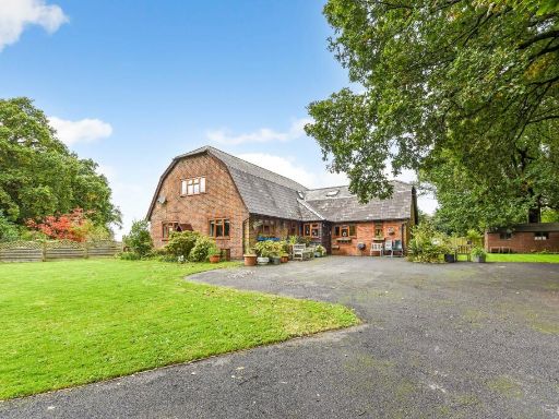 5 bedroom detached house for sale in Barn Lane, Four Marks, Alton, Hampshire, GU34 — £1,290,000 • 5 bed • 3 bath • 2700 ft²
 Equestrian facility for sale in Bow Lake Equestrian Centre, Portsmouth Road, SO50 7HF, SO50 — £2,000,000 • 2 bed • 2 bath • 3104 ft²
 4 bedroom detached house for sale in Amport, Andover, Hampshire, SP11 — £3,250,000 • 4 bed • 3 bath • 8273 ft²
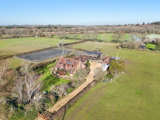 3 bedroom detached house for sale in Ossemsley, Christchurch, BH23 — £1,350,000 • 3 bed • 2 bath • 5098 ft²
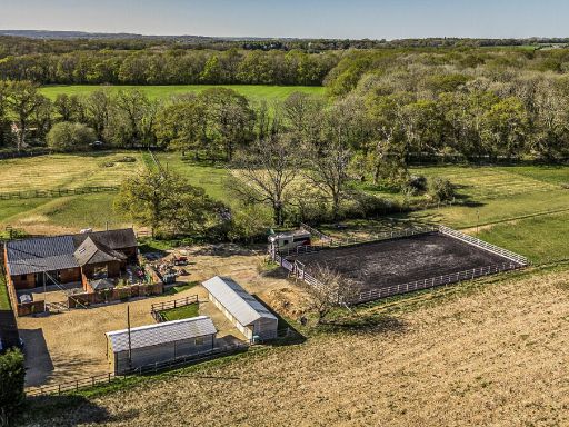 3 bedroom detached house for sale in Winchester HAMPSHIRE, SO50 — £1,000,000 • 3 bed • 1 bath • 3198 ft²
Meta
- {
"@context": "https://schema.org",
"@type": "Residence",
"name": "Land for sale in Amport, Andover, Hampshire, SP11",
"description": "",
"url": "https://propertypiper.co.uk/property/ac22d83d-1384-45db-9726-87d162e123c7",
"image": "https://image-a.propertypiper.co.uk/42009425-fd3a-4d51-9ff6-ff3ce6edc57b-1024.jpeg",
"address": {
"@type": "PostalAddress",
"streetAddress": "Amport Riding Centre, Furzedown Lane",
"postalCode": "SP11 8BE",
"addressLocality": "Test Valley",
"addressRegion": "North West Hampshire",
"addressCountry": "England"
},
"geo": {
"@type": "GeoCoordinates",
"latitude": 51.19603075826415,
"longitude": -1.5774265851768932
},
"numberOfRooms": 3,
"numberOfBathroomsTotal": 1,
"floorSize": {
"@type": "QuantitativeValue",
"value": 1507,
"unitCode": "FTK"
},
"offers": {
"@type": "Offer",
"price": 1500000,
"priceCurrency": "GBP",
"availability": "https://schema.org/InStock"
},
"additionalProperty": [
{
"@type": "PropertyValue",
"name": "Feature",
"value": "equestrian"
},
{
"@type": "PropertyValue",
"name": "Feature",
"value": "agricultural"
},
{
"@type": "PropertyValue",
"name": "Feature",
"value": "stable"
},
{
"@type": "PropertyValue",
"name": "Feature",
"value": "paddock"
},
{
"@type": "PropertyValue",
"name": "Feature",
"value": "arena"
},
{
"@type": "PropertyValue",
"name": "Feature",
"value": "rural"
},
{
"@type": "PropertyValue",
"name": "Feature",
"value": "countryside"
},
{
"@type": "PropertyValue",
"name": "Feature",
"value": "spacious"
},
{
"@type": "PropertyValue",
"name": "Feature",
"value": "land"
},
{
"@type": "PropertyValue",
"name": "Feature",
"value": "recreational"
},
{
"@type": "PropertyValue",
"name": "Feature",
"value": "rural"
},
{
"@type": "PropertyValue",
"name": "Feature",
"value": "estate"
},
{
"@type": "PropertyValue",
"name": "Feature",
"value": "land"
},
{
"@type": "PropertyValue",
"name": "Feature",
"value": "countryside"
},
{
"@type": "PropertyValue",
"name": "Feature",
"value": "acreage"
},
{
"@type": "PropertyValue",
"name": "Feature",
"value": "agriculture"
},
{
"@type": "PropertyValue",
"name": "Feature",
"value": "open fields"
}
]
}