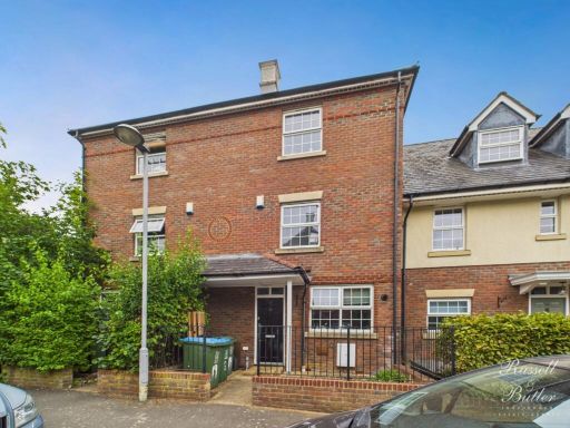
MK18 1SN - 4 bedroom town house for sale in Fishers Field, Buckingham,…
View on Property Piper
4 bedroom town house for sale in Fishers Field, Buckingham, MK18
Property Details
- Price: £389995
- Bedrooms: 4
- Bathrooms: 2
- Property Type: undefined
- Property SubType: undefined
Image Descriptions
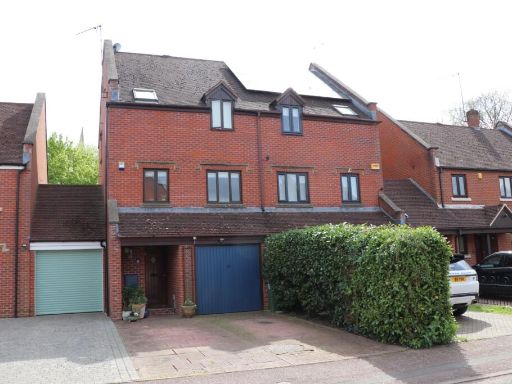
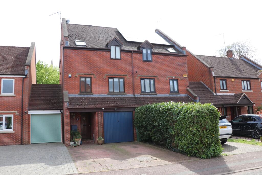
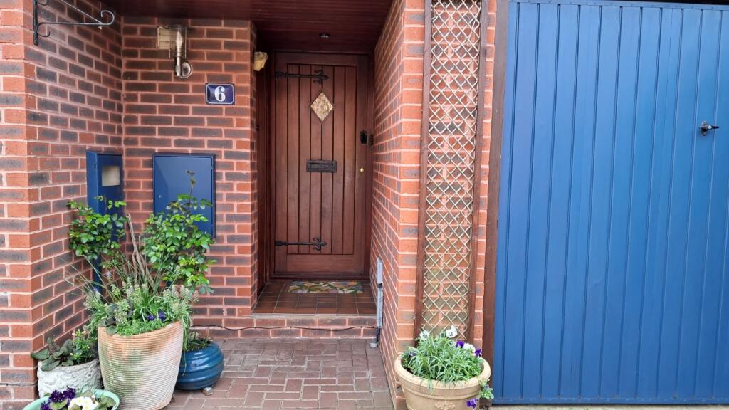
- row of townhouses modern with traditional elements
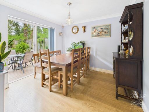
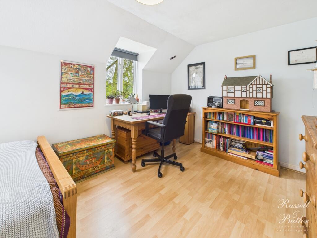
- dining room modern
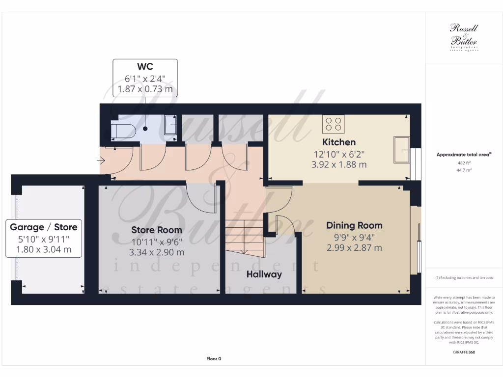
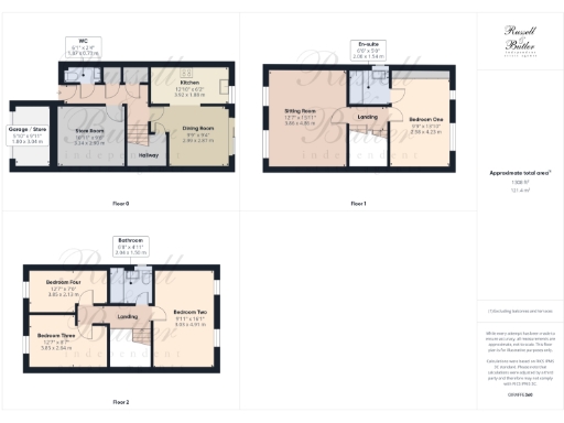
Floorplan Description
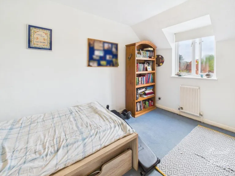
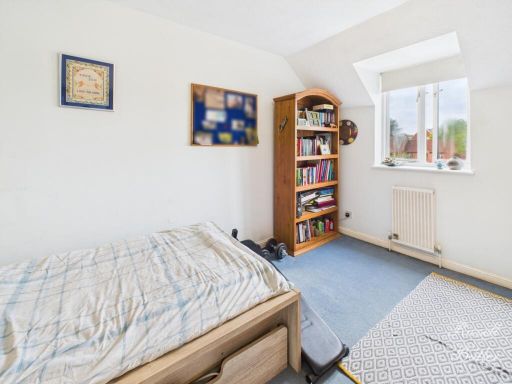
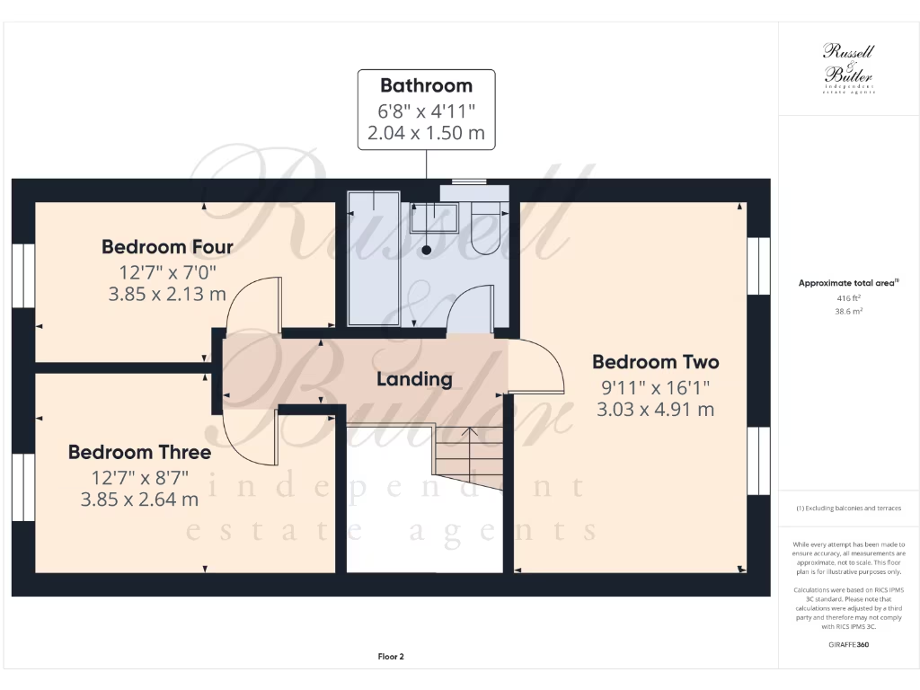
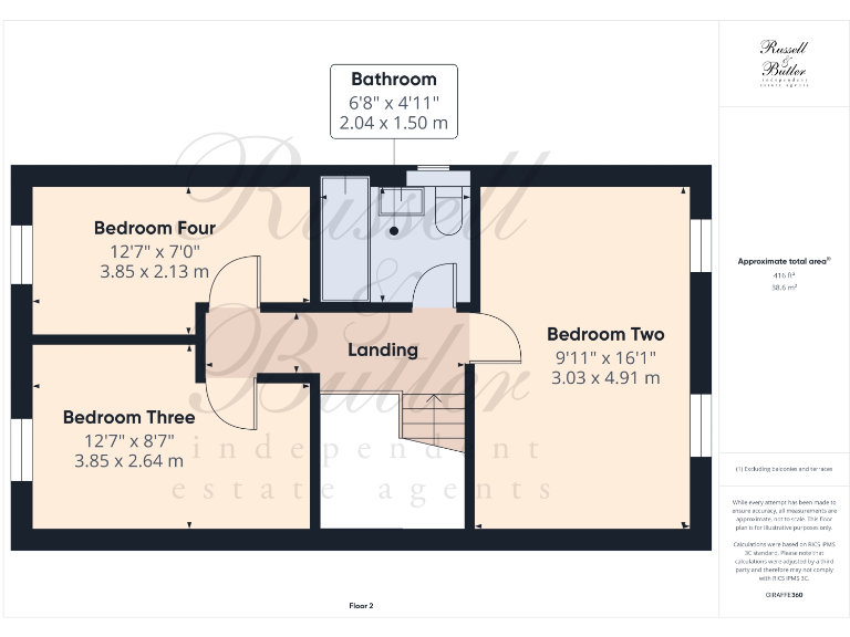
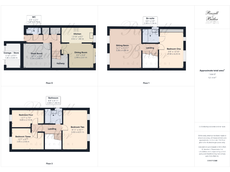
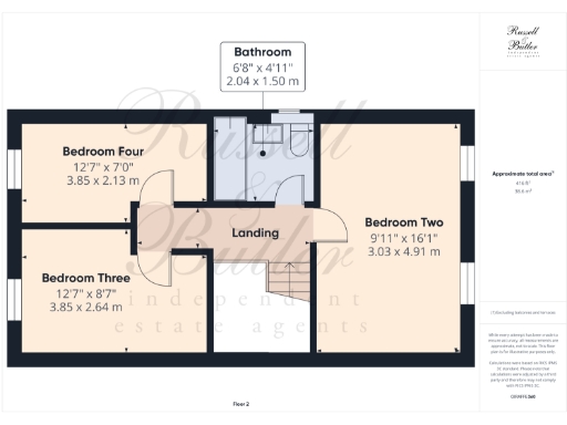
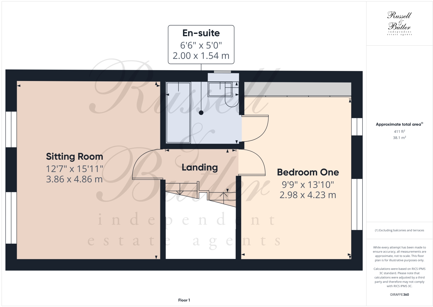
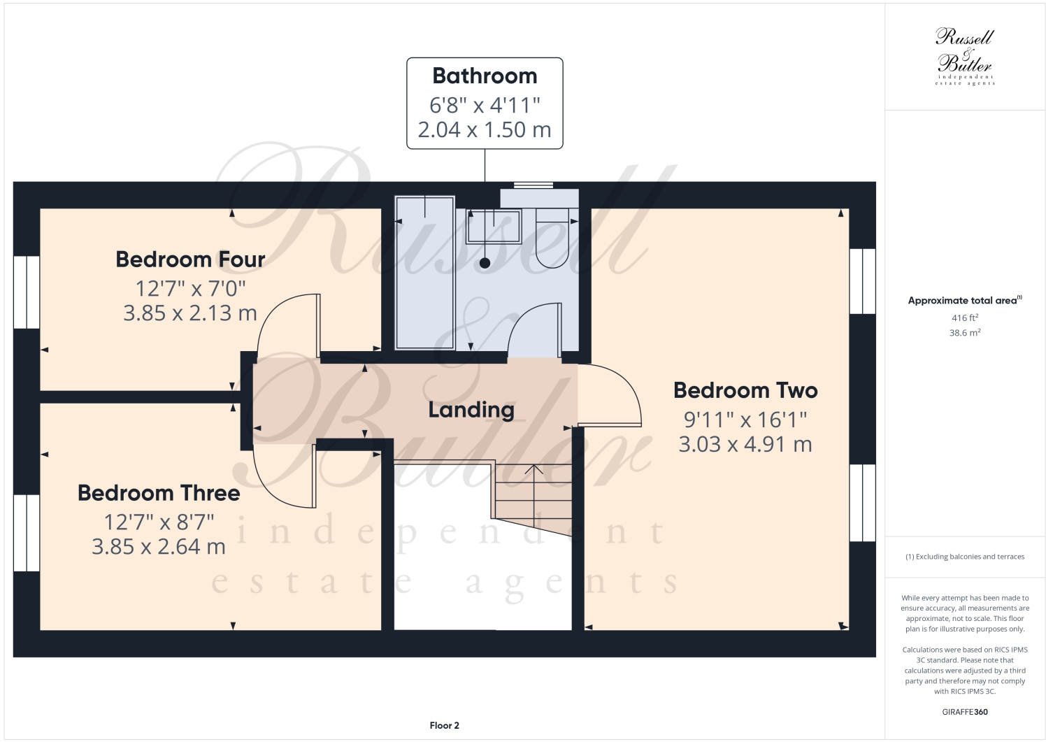
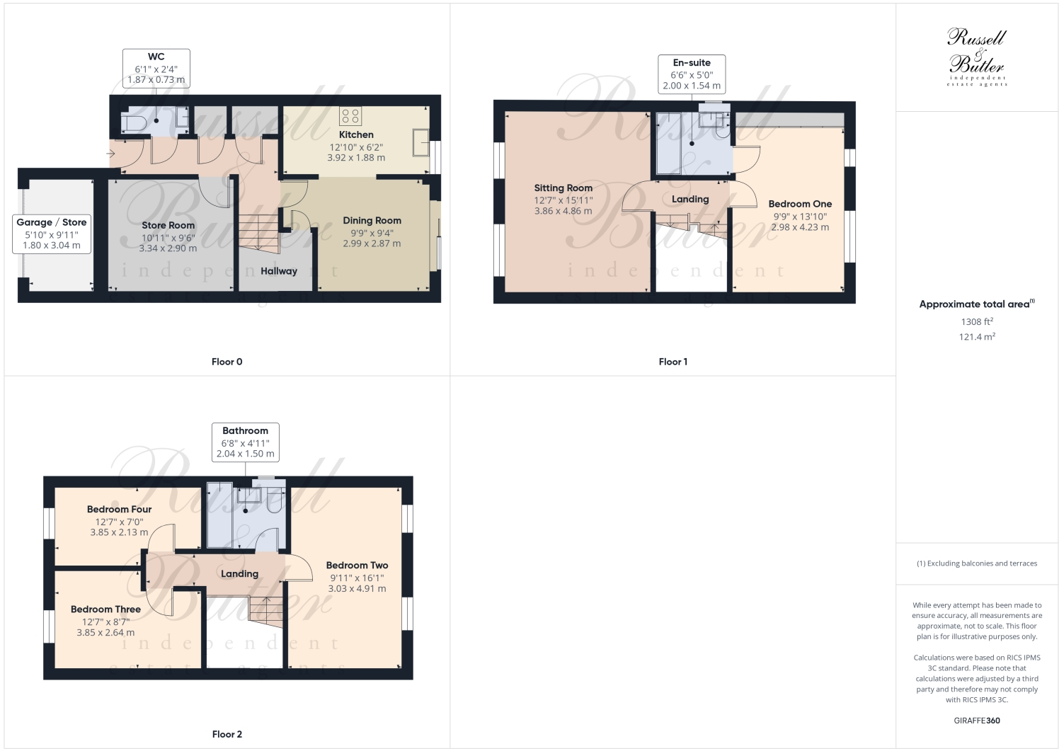
- A property featuring a bathroom, and three bedrooms on the second floor.
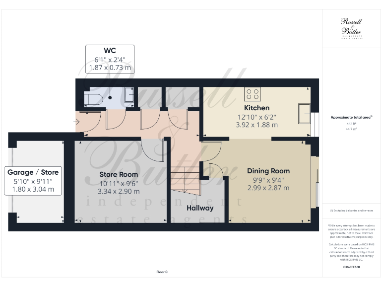
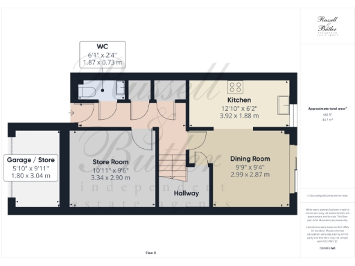
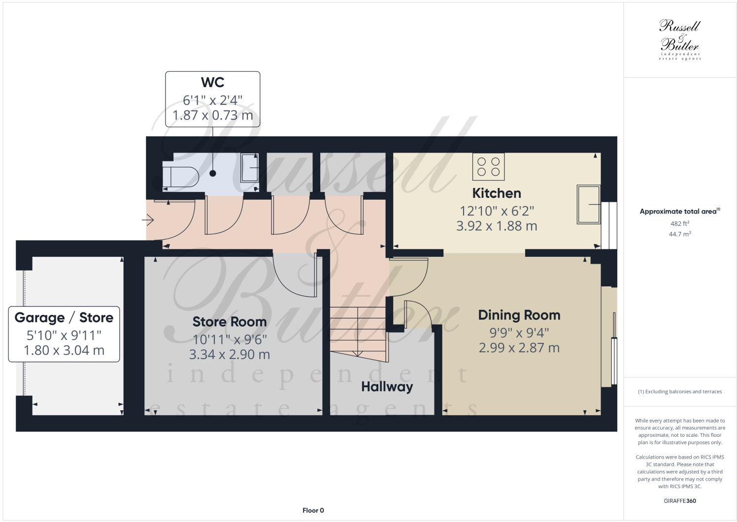
- A multi-story property featuring a garage/store room, multiple bedrooms, and bathrooms distributed over three floors.
Rooms
- WC: Small
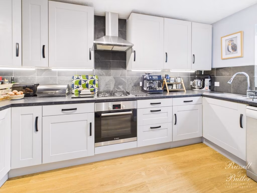
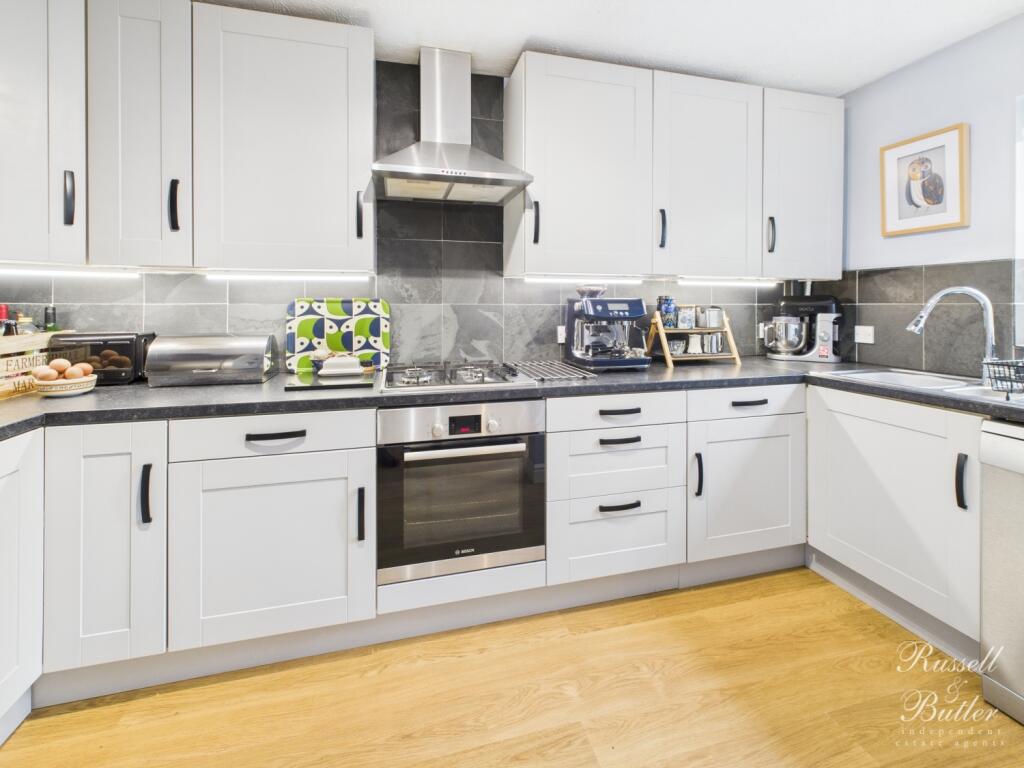
- Kitchen: Average
- Dining Room: Average
- Store Room: Average
- Garage / Store: Average
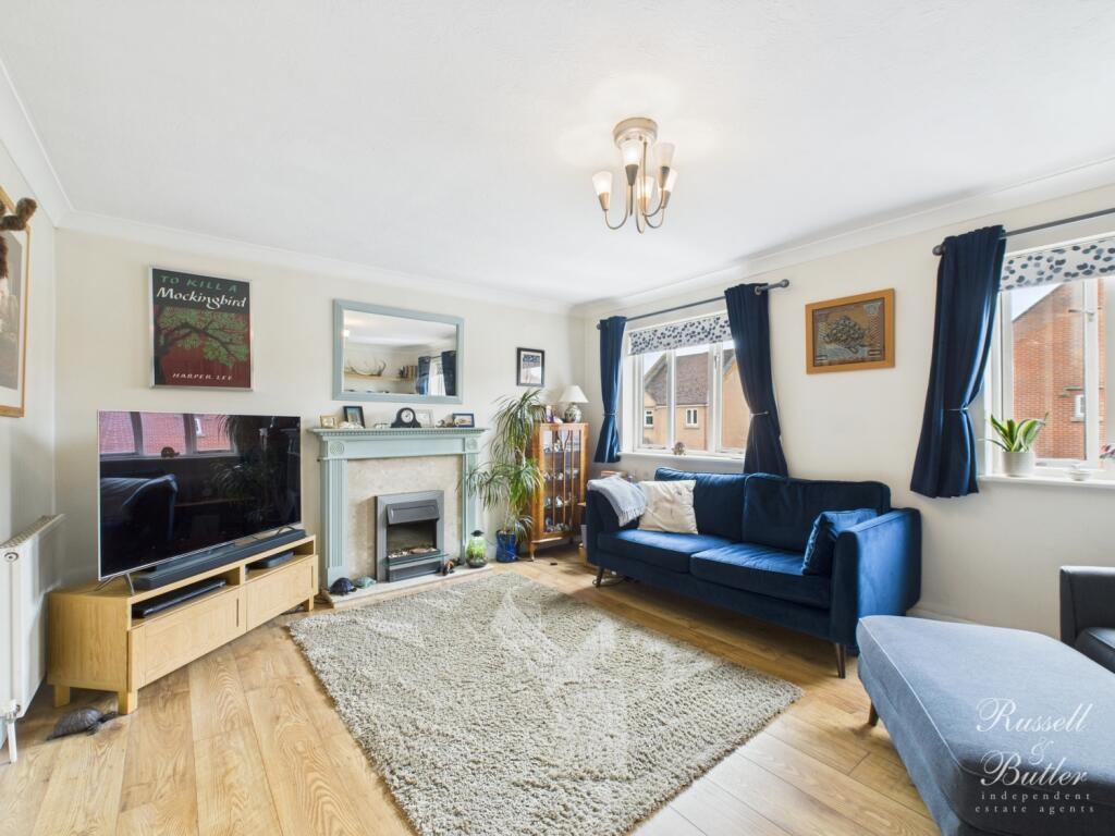
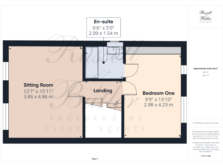
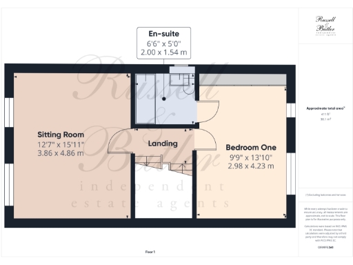
- Sitting Room: Large
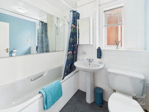
- En-suite: Small
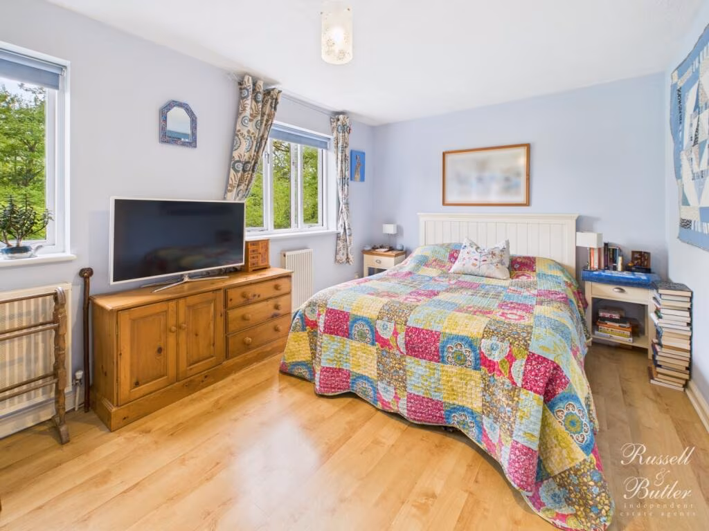
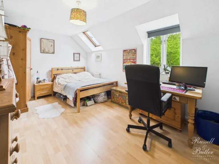
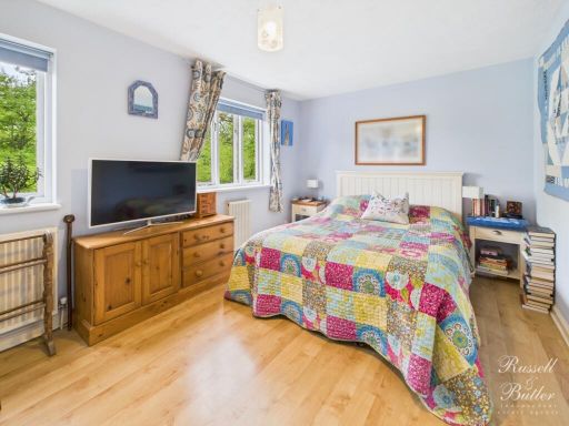
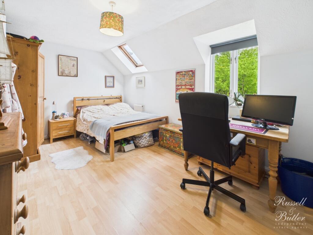
- Bedroom One: Average
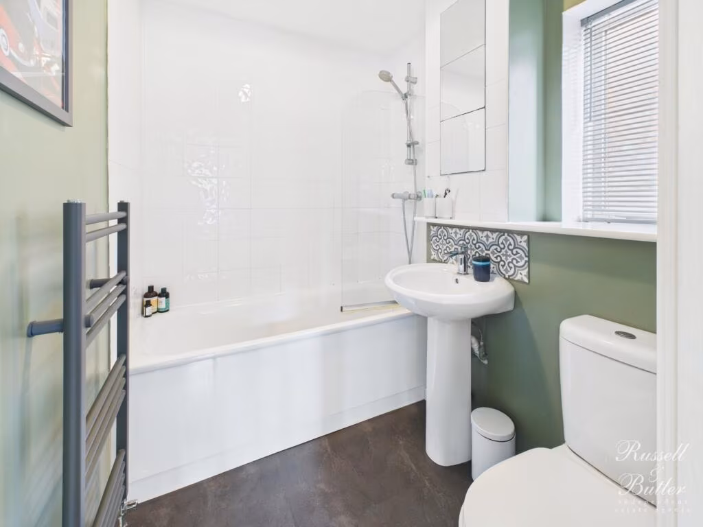
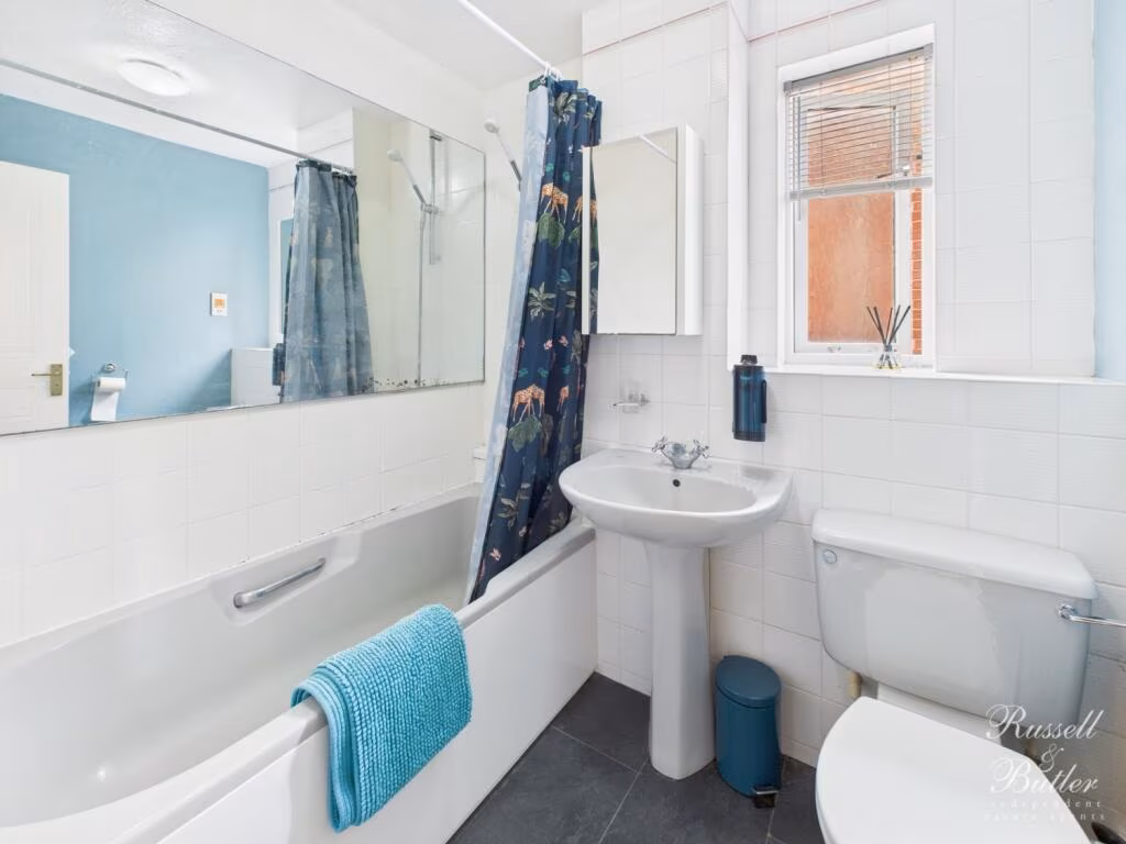
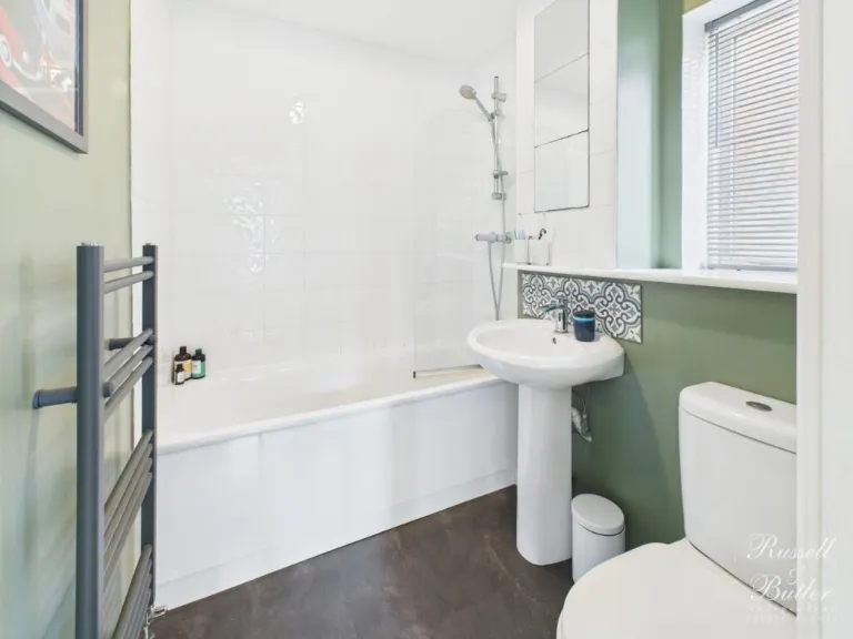
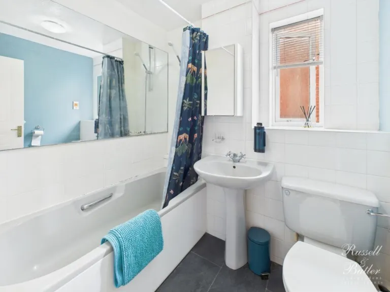
- Bathroom:
- Bedroom Two:
- Bedroom Three:
- Bedroom Four:
- WC:
- Garage / Store:
- Store Room:
- Kitchen:
- Dining Room:
- Sitting Room:
- Bedroom One:
- En-suite:
- Bedroom Four:
- Bedroom Three:
- Bathroom:
- Bedroom Two:
Textual Property Features
Detected Visual Features
- modern house
- townhouse
- three stories
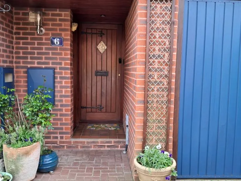
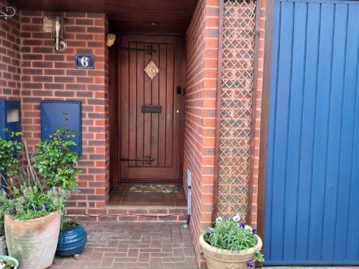
- brick facade
- garage
- driveway
- residential
- family home
- modern
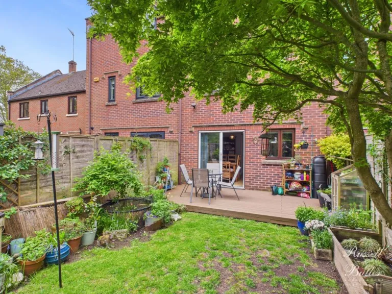
- dining room
- patio doors
- wood flooring
- medium-sized
- bright
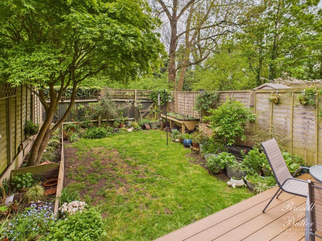
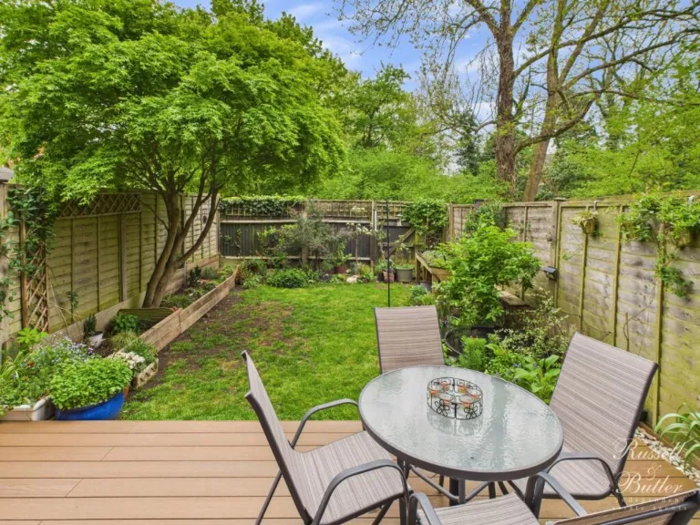
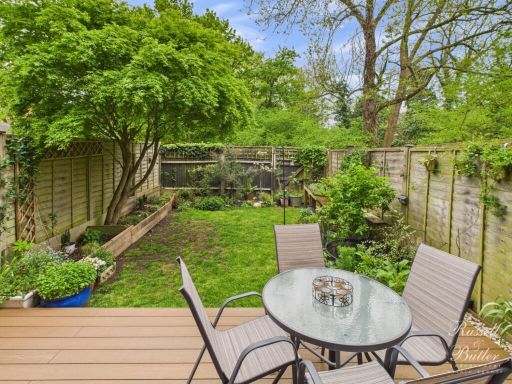
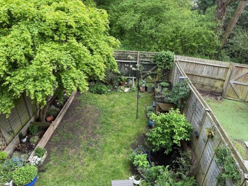
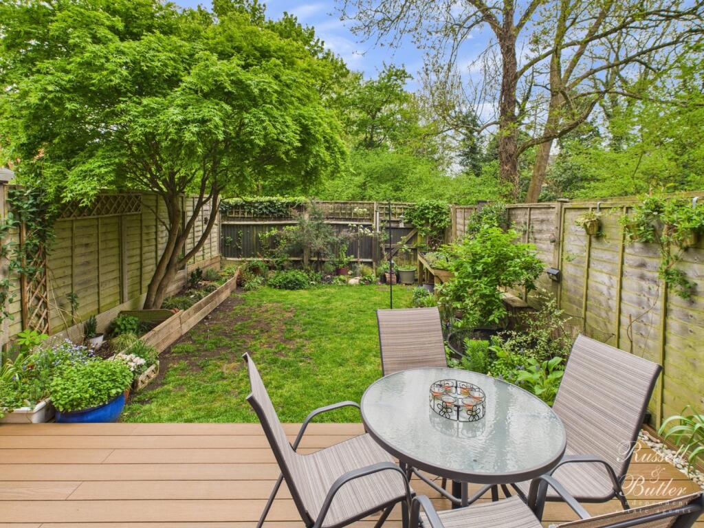
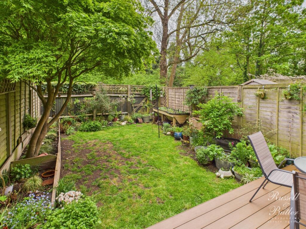
- garden access
EPC Details
- Fully double glazed
- Cavity wall, as built, insulated (assumed)
- Boiler and radiators, mains gas
- Low energy lighting in all fixed outlets
- Solid, limited insulation (assumed)
Nearby Schools
- Thornton College
- St James and St John CofE Primary School
- Stowe School
- Steeple Claydon School and Pre-School
- Buckingham School
- George Grenville Academy
- Twyford C of E School
- Akeley Wood Senior School
- Akeley Wood Junior School
- Sir Thomas Fremantle School
- Royal Latin School
- Bourton Meadow Academy
- Buckingham Primary School
- Maids Moreton Church of England School
- Padbury Church of England School
- Great Horwood Church of England School
- Finmere Church of England Primary School
- Beachborough School
- Syresham St James CofE Primary School and Nursery
- Lace Hill Academy
- Thornborough Infant School
- Roundwood Primary School
Nearest Bars And Restaurants
- Id: 6222623587
- Tags:
- Amenity: cafe
- Cuisine: tea;cake;coffee_shop
- Name: Esquires Coffee
- TagsNormalized:
- Lat: 52.0000282
- Lon: -0.9883852
- FullGeoHash: gcprcd260gyd
- PartitionGeoHash: gcpr
- Images:
- FoodStandards: null
- Distance: 320.4
,- Id: 3463630693
- Tags:
- Amenity: pub
- Name: The Woolpack
- Source: survey
- Survey:
- TagsNormalized:
- Lat: 51.9981324
- Lon: -0.9878577
- FullGeoHash: gcprc9bxj4rv
- PartitionGeoHash: gcpr
- Images:
- FoodStandards: null
- Distance: 286
,- Id: 4347573826
- Tags:
- Amenity: fast_food
- Cuisine: fish_and_chips
- Drive_through: no
- Name: Fish & Chips
- TagsNormalized:
- Lat: 51.9984422
- Lon: -0.9879109
- FullGeoHash: gcprcd08uh0j
- PartitionGeoHash: gcpr
- Images:
- FoodStandards: null
- Distance: 283.2
,- Id: 4350020408
- Tags:
- Amenity: restaurant
- Cuisine: indian
- Name: The Buckingham Fort
- TagsNormalized:
- Lat: 52.0000587
- Lon: -0.9899255
- FullGeoHash: gcprc6r4m1d0
- PartitionGeoHash: gcpr
- Images:
- FoodStandards: null
- Distance: 250
,- Id: 4347490176
- Tags:
- Amenity: fast_food
- Delivery: yes
- Drive_through: no
- Name: Buckingham Tandoori
- Takeaway: only
- TagsNormalized:
- fast food
- food
- tandoori
- takeaway
- Lat: 51.9975861
- Lon: -0.9907416
- FullGeoHash: gcprc3yefh9e
- PartitionGeoHash: gcpr
- Images:
- FoodStandards: null
- Distance: 113.2
}
Nearest General Shops
- Id: 4350020440
- Tags:
- Name: Buckingham Cleaning Centre
- Shop: dry_cleaning
- TagsNormalized:
- Lat: 51.9977922
- Lon: -0.9946227
- FullGeoHash: gcprc3gtpe58
- PartitionGeoHash: gcpr
- Images:
- FoodStandards: null
- Distance: 183.7
,- Id: 4350020441
- Tags:
- Name: Buckingham Cleaning Centre
- Shop: laundry
- TagsNormalized:
- Lat: 51.9977798
- Lon: -0.9945637
- FullGeoHash: gcprc3gv0bxw
- PartitionGeoHash: gcpr
- Images:
- FoodStandards: null
- Distance: 180.1
,- Id: 9789026079
- Tags:
- Name: Buckingham Local
- Shop: supermarket
- TagsNormalized:
- Lat: 51.9976531
- Lon: -0.9905935
- FullGeoHash: gcprc3ysm3pf
- PartitionGeoHash: gcpr
- Images:
- FoodStandards: null
- Distance: 117.1
}
Nearest Grocery shops
- Id: 4347562273
- Tags:
- Addr:
- City: Buckingham
- Street: Chandos Road
- Brand: Sainsbury's Local
- Brand:wikidata: Q13218434
- Brand:wikipedia: en:Sainsbury's Local
- Name: Sainsbury's Local
- Shop: convenience
- TagsNormalized:
- sainsburys
- sainsburys local
- convenience
- shop
- Lat: 51.9968452
- Lon: -0.985521
- FullGeoHash: gcprc9dredqr
- PartitionGeoHash: gcpr
- Images:
- FoodStandards: null
- Distance: 471.4
,- Id: 231736381
- Tags:
- Addr:
- City: Buckingham
- Housenumber: 8-10
- Postcode: MK18 1JX
- Street: Market Hill
- Brand: Tesco Express
- Brand:wikidata: Q98456772
- Brand:wikipedia: en:Tesco
- Building: retail
- Contact:
- Website: https://www.tesco.com/store-locator/buckingham/8-10-market-hill
- Layer: 2
- Name: Tesco Express
- Opening_hours: Mo-Su 06:00-22:00
- Operator: Tesco plc
- Shop: convenience
- TagsNormalized:
- tesco
- tesco express
- retail
- convenience
- shop
- Lat: 52.000952
- Lon: -0.9869134
- FullGeoHash: gcprcd3re201
- PartitionGeoHash: gcpr
- Images:
- FoodStandards: null
- Distance: 463.6
,- Id: 6222629385
- Tags:
- Name: Buckingham Stores
- Shop: convenience
- TagsNormalized:
- Lat: 52.0000646
- Lon: -0.988522
- FullGeoHash: gcprcd24mf8e
- PartitionGeoHash: gcpr
- Images:
- FoodStandards: null
- Distance: 315.8
}
Nearest Supermarkets
- Id: 173579146
- Tags:
- Addr:
- Postcode: MK18 1AB
- Street: London Road
- Brand: Tesco
- Brand:wikidata: Q487494
- Brand:wikipedia: en:Tesco
- Building: yes
- Contact:
- Website: https://www.tesco.com/store-locator/buckingham/london-rd
- Layer: 2
- Name: Tesco
- Shop: supermarket
- TagsNormalized:
- Lat: 51.9892654
- Lon: -0.9814707
- FullGeoHash: gcprc8m76jd2
- PartitionGeoHash: gcpr
- Images:
- FoodStandards: null
- Distance: 1230.8
,- Id: 62069053
- Tags:
- Brand: ALDI
- Brand:wikidata: Q41171672
- Brand:wikipedia: en:Aldi
- Building: shop
- Contact:
- Website: https://stores.aldi.co.uk/buckingham/osier-way
- Name: Aldi
- Shop: supermarket
- Source: OS OpenData StreetView
- TagsNormalized:
- Lat: 51.9891299
- Lon: -0.9902822
- FullGeoHash: gcprc2qfsu0p
- PartitionGeoHash: gcpr
- Images:
- FoodStandards: null
- Distance: 1018.1
,- Id: 173581052
- Tags:
- Addr:
- Postcode: MK18 1RS
- Street: Meadow Walk, High Street
- Brand: Waitrose
- Brand:wikidata: Q771734
- Brand:wikipedia: en:Waitrose
- Building: yes
- Name: Waitrose
- Official_name: Waitrose & Partners
- Operator: Waitrose & Partners
- Payment:
- Cash: yes
- Credit_cards: yes
- Shop: supermarket
- TagsNormalized:
- Lat: 52.000489
- Lon: -0.9848488
- FullGeoHash: gcprcd6ug3ex
- PartitionGeoHash: gcpr
- Images:
- FoodStandards: null
- Distance: 552.6
}
Nearest Religious buildings
- Id: 2289013655
- Tags:
- Amenity: place_of_worship
- Denomination: catholic
- Name: St. Bernadine's
- Religion: christian
- Source: local_knowledge
- Wikidata: Q7592657
- Wikipedia: en:St Bernardine's Catholic Church, Buckingham
- TagsNormalized:
- place of worship
- catholic
- christian
- church
- Lat: 51.9941478
- Lon: -0.989558
- FullGeoHash: gcprc3prvesh
- PartitionGeoHash: gcpr
- Images:
- FoodStandards: null
- Distance: 483.7
,- Id: 3438018653
- Tags:
- Addr:
- City: Buckingham
- Country: GB
- Postcode: MK18 1JZ
- Street: Moreton Road
- Amenity: place_of_worship
- Denomination: salvation_army
- Name: Buckingham Salvation Army
- Religion: christian
- Source: survey
- TagsNormalized:
- place of worship
- salvation army
- christian
- church
- Lat: 52.0012367
- Lon: -0.9869519
- FullGeoHash: gcprcd934m57
- PartitionGeoHash: gcpr
- Images:
- FoodStandards: null
- Distance: 483
,- Id: 427601266
- Tags:
- Addr:
- Amenity: place_of_worship
- Building: church
- Denomination: anglican
- Name: St. Peter & St. Paul Buckingham Parish
- Religion: christian
- Source: bing
- Wheelchair: yes
- Wikidata: Q7595368
- Wikipedia: en:St Peter and St Paul, Buckingham
- TagsNormalized:
- place of worship
- church
- anglican
- parish
- paul
- christian
- Lat: 51.9981049
- Lon: -0.9895466
- FullGeoHash: gcprc3zqvvk9
- PartitionGeoHash: gcpr
- Images:
- FoodStandards: null
- Distance: 170.7
}
Nearest Medical buildings
- Id: 4803956822
- Tags:
- Amenity: dentist
- Healthcare: dentist
- Name: Meadow Walk Dental Practice
- Name:en: Meadow Walk Dental Practice
- TagsNormalized:
- dentist
- health
- healthcare
- dental
- meadow
- Lat: 52.0008151
- Lon: -0.9854757
- FullGeoHash: gcprcd6qsy80
- PartitionGeoHash: gcpr
- Images:
- FoodStandards: null
- Distance: 533.5
,- Id: 4347797573
- Tags:
- Amenity: doctors
- Healthcare: doctor
- Name: Verney Close Surgery
- TagsNormalized:
- doctor
- doctors
- health
- healthcare
- surgery
- Lat: 51.9996642
- Lon: -0.9857129
- FullGeoHash: gcprcd4pzpzp
- PartitionGeoHash: gcpr
- Images:
- FoodStandards: null
- Distance: 461.4
,- Id: 1843681523
- Tags:
- Addr:
- City: Buckingham
- Housenumber: 11
- Postcode: MK18 1JX
- Street: Market Hill
- Amenity: pharmacy
- Brand: Boots
- Brand:wikidata: Q6123139
- Brand:wikipedia: en:Boots (company)
- Healthcare: pharmacy
- Name: Boots
- TagsNormalized:
- pharmacy
- boots
- health
- healthcare
- Lat: 52.0008153
- Lon: -0.9870187
- FullGeoHash: gcprcd3q8y99
- PartitionGeoHash: gcpr
- Images:
- FoodStandards: null
- Distance: 448.3
,- Id: 6222632687
- Tags:
- Amenity: pharmacy
- Healthcare: pharmacy
- Name: Jardines
- Operator: Jardines (U.K.) Ltd
- TagsNormalized:
- Lat: 52.0005148
- Lon: -0.9869887
- FullGeoHash: gcprcd3kcqxc
- PartitionGeoHash: gcpr
- Images:
- FoodStandards: null
- Distance: 429.2
}
Nearest Airports
- Id: 110273499
- Tags:
- Addr:
- Country: GB
- Postcode: LU2 9LY
- Aerodrome: international
- Aerodrome:type: public
- Aeroway: aerodrome
- Alt_name: London Luton
- Iata: LTN
- Icao: EGGW
- Name: London Luton Airport
- Website: https://www.london-luton.co.uk/
- Wikidata: Q8712
- Wikipedia: en:Luton Airport
- TagsNormalized:
- airport
- international airport
- Lat: 51.8780363
- Lon: -0.3701408
- FullGeoHash: gcpxps47rngh
- PartitionGeoHash: gcpx
- Images:
- FoodStandards: null
- Distance: 44677.9
}
Nearest Leisure Facilities
- Id: 100639057
- Tags:
- Leisure: pitch
- Source: bing
- Sport: soccer
- TagsNormalized:
- Lat: 51.9966893
- Lon: -0.9877384
- FullGeoHash: gcprc98y8j2v
- PartitionGeoHash: gcpr
- Images:
- FoodStandards: null
- Distance: 339.8
,- Id: 436926983
- Tags:
- Leisure: pitch
- Sport: basketball
- TagsNormalized:
- pitch
- leisure
- basketball
- sports
- Lat: 51.9952735
- Lon: -0.9910166
- FullGeoHash: gcprc3qq7tkr
- PartitionGeoHash: gcpr
- Images:
- FoodStandards: null
- Distance: 335.2
,- Id: 436927711
- Tags:
- TagsNormalized:
- Lat: 51.9961429
- Lon: -0.9885225
- FullGeoHash: gcprc985mz81
- PartitionGeoHash: gcpr
- Images:
- FoodStandards: null
- Distance: 333.5
,- Id: 436921927
- Tags:
- TagsNormalized:
- Lat: 51.9953596
- Lon: -0.9933783
- FullGeoHash: gcprc3kwute3
- PartitionGeoHash: gcpr
- Images:
- FoodStandards: null
- Distance: 331.4
,- Id: 4349995151
- Tags:
- Leisure: fitness_centre
- Name: intent 2 improve
- Sport: fitness
- Website: intent2improve.com
- TagsNormalized:
- fitness
- fitness centre
- leisure
- sports
- Lat: 51.9995092
- Lon: -0.9887447
- FullGeoHash: gcprcd0p0e4d
- PartitionGeoHash: gcpr
- Images:
- FoodStandards: null
- Distance: 266.7
}
Nearest Tourist attractions
- Id: 1639957990
- Tags:
- TagsNormalized:
- Lat: 51.9922273
- Lon: -0.9384366
- FullGeoHash: gcprf8ussvdu
- PartitionGeoHash: gcpr
- Images:
- FoodStandards: null
- Distance: 3729.6
,- Id: 361948944
- Tags:
- Addr:
- City: Buckingham
- Postcode: MK18 1JX
- Street: Market Hill
- Building: yes
- Name: Buckingham Old Gaol
- Opening_hours: Mo-Sa 10:00-16:00
- Operator: Buckingham Old Gaol Trust
- Tourism: museum
- Website: https://buckinghamoldgaol.org.uk/
- Wikidata: Q15205486
- Wikipedia: en:Buckingham Old Gaol
- TagsNormalized:
- Lat: 52.0009089
- Lon: -0.9864024
- FullGeoHash: gcprcd3xr0j0
- PartitionGeoHash: gcpr
- Images:
- FoodStandards: null
- Distance: 487.7
,- Id: 4347797789
- Tags:
- Name: Tourist Information Centre
- Tourism: attraction
- TagsNormalized:
- information
- attraction
- tourism
- Lat: 52.0008235
- Lon: -0.986517
- FullGeoHash: gcprcd3wu2pd
- PartitionGeoHash: gcpr
- Images:
- FoodStandards: null
- Distance: 475.6
}
Nearest Bus stations and stops
- Id: 440974278
- Tags:
- Bench: yes
- Bus: yes
- Highway: bus_stop
- Name: Buckingham Tesco
- Public_transport: platform
- Shelter: yes
- TagsNormalized:
- Lat: 51.9892203
- Lon: -0.9789181
- FullGeoHash: gcprc8r5jt1g
- PartitionGeoHash: gcpr
- Images:
- FoodStandards: null
- Distance: 1344.7
,- Id: 4349995124
- Tags:
- Bus: yes
- Highway: bus_stop
- Public_transport: platform
- Shelter: yes
- TagsNormalized:
- Lat: 52.0020431
- Lon: -0.9742272
- FullGeoHash: gcprcfdtfg7w
- PartitionGeoHash: gcpr
- Images:
- FoodStandards: null
- Distance: 1290.9
,- Id: 4349995125
- Tags:
- Bus: yes
- Highway: bus_stop
- Public_transport: platform
- Shelter: no
- TagsNormalized:
- Lat: 52.0019465
- Lon: -0.9743801
- FullGeoHash: gcprcfdmr33t
- PartitionGeoHash: gcpr
- Images:
- FoodStandards: null
- Distance: 1277.5
,- Id: 4352574238
- Tags:
- Bench: yes
- Bin: yes
- Bus: yes
- Departures_board: realtime
- Highway: bus_stop
- Name: Buckingham High Street
- Public_transport: platform
- Shelter: yes
- TagsNormalized:
- Lat: 52.0016819
- Lon: -0.9850636
- FullGeoHash: gcprcddey257
- PartitionGeoHash: gcpr
- Images:
- FoodStandards: null
- Distance: 612.9
,- Id: 4347773186
- Tags:
- Bus: yes
- Covered: no
- Highway: bus_stop
- Name: Royal Latin School Bus Station
- Public_transport: platform
- TagsNormalized:
- Lat: 51.9936309
- Lon: -0.988257
- FullGeoHash: gcprc90kggq1
- PartitionGeoHash: gcpr
- Images:
- FoodStandards: null
- Distance: 572.3
}
Nearest Hotels
- Id: 4349953293
- Tags:
- Brand: Travelodge
- Brand:wikidata: Q9361374
- Brand:wikipedia: en:Travelodge UK
- Name: Travelodge
- Tourism: hotel
- TagsNormalized:
- Lat: 51.990014
- Lon: -0.9777765
- FullGeoHash: gcprcb2pb1hc
- PartitionGeoHash: gcpr
- Images:
- FoodStandards: null
- Distance: 1336.3
,- Id: 773523998
- Tags:
- Brand: Best Western
- Brand:wikidata: Q830334
- Brand:wikipedia: en:Best Western
- Name: Best Western
- Source: survey
- Tourism: hotel
- TagsNormalized:
- Lat: 51.9885559
- Lon: -0.986662
- FullGeoHash: gcprc81x315r
- PartitionGeoHash: gcpr
- Images:
- FoodStandards: null
- Distance: 1136
,- Id: 437177236
- Tags:
- Addr:
- Housenumber: 3
- Postcode: MK18 1BS
- Street: Castle Street
- Building: hotel
- Name: Villiers Hotel
- Opening_hours: 24/7
- Phone: +44 1280822444
- Stars: 4
- Tourism: hotel
- Wikidata: Q26570225
- TagsNormalized:
- Lat: 51.9997841
- Lon: -0.9887387
- FullGeoHash: gcprcd208wqf
- PartitionGeoHash: gcpr
- Images:
- FoodStandards: null
- Distance: 284.6
}
Tags
- modern house
- townhouse
- three stories
- brick facade
- garage
- driveway
- residential
- family home
- modern
- dining room
- patio doors
- wood flooring
- medium-sized
- bright
- garden access
Local Market Stats
- Average Price/sqft: £363
- Avg Income: £56100
- Rental Yield: 3.4%
- Social Housing: 8%
- Planning Success Rate: 81%
AirBnB Data
- 1km average: £70/night
- Listings in 1km: 6
Similar Properties
 4 bedroom town house for sale in Bernardines Way, Buckingham, Buckinghamshire, MK18 — £489,995 • 4 bed • 3 bath • 1549 ft²
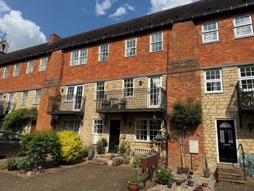 3 bedroom town house for sale in Old School Court, Buckingham, MK18 — £399,995 • 3 bed • 1 bath • 968 ft²
 3 bedroom terraced house for sale in Cecil's Yard, Buckingham, MK18 — £359,995 • 3 bed • 2 bath • 969 ft²
 4 bedroom town house for sale in Bernardines Way, Buckingham, MK18 — £559,995 • 4 bed • 2 bath • 1343 ft²
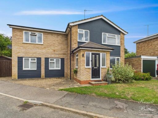 4 bedroom detached house for sale in Sandhurst Drive, Buckingham, MK18 — £525,000 • 4 bed • 2 bath • 1397 ft²
 5 bedroom detached house for sale in Moorhen Way, Buckingham, Buckinghamshire, MK18 — £725,000 • 5 bed • 4 bath • 2232 ft²
Meta
- {
"@context": "https://schema.org",
"@type": "Residence",
"name": "4 bedroom town house for sale in Fishers Field, Buckingham,…",
"description": "",
"url": "https://propertypiper.co.uk/property/a43de3e6-8190-4431-97bb-74aadd8fac11",
"image": "https://image-a.propertypiper.co.uk/4756b95c-8be2-449b-97f5-1184e1d361e3-1024.jpeg",
"address": {
"@type": "PostalAddress",
"streetAddress": "6 FISHERS FIELD BUCKINGHAM ",
"postalCode": "MK18 1SN",
"addressLocality": "Buckinghamshire",
"addressRegion": "Buckingham",
"addressCountry": "England"
},
"geo": {
"@type": "GeoCoordinates",
"latitude": 51.9982223,
"longitude": -0.9920327
},
"numberOfRooms": 4,
"numberOfBathroomsTotal": 2,
"floorSize": {
"@type": "QuantitativeValue",
"value": 1308,
"unitCode": "FTK"
},
"offers": {
"@type": "Offer",
"price": 389995,
"priceCurrency": "GBP",
"availability": "https://schema.org/InStock"
},
"additionalProperty": [
{
"@type": "PropertyValue",
"name": "Feature",
"value": "modern house"
},
{
"@type": "PropertyValue",
"name": "Feature",
"value": "townhouse"
},
{
"@type": "PropertyValue",
"name": "Feature",
"value": "three stories"
},
{
"@type": "PropertyValue",
"name": "Feature",
"value": "brick facade"
},
{
"@type": "PropertyValue",
"name": "Feature",
"value": "garage"
},
{
"@type": "PropertyValue",
"name": "Feature",
"value": "driveway"
},
{
"@type": "PropertyValue",
"name": "Feature",
"value": "residential"
},
{
"@type": "PropertyValue",
"name": "Feature",
"value": "family home"
},
{
"@type": "PropertyValue",
"name": "Feature",
"value": "modern"
},
{
"@type": "PropertyValue",
"name": "Feature",
"value": "dining room"
},
{
"@type": "PropertyValue",
"name": "Feature",
"value": "patio doors"
},
{
"@type": "PropertyValue",
"name": "Feature",
"value": "wood flooring"
},
{
"@type": "PropertyValue",
"name": "Feature",
"value": "medium-sized"
},
{
"@type": "PropertyValue",
"name": "Feature",
"value": "bright"
},
{
"@type": "PropertyValue",
"name": "Feature",
"value": "garden access"
}
]
}
High Res Floorplan Images
Compatible Floorplan Images
FloorplanImages Thumbnail