BL6 6ND - 3 bedroom semidetached house for sale in Lancaster Avenue,…
View on Property Piper
3 bedroom semi-detached house for sale in Lancaster Avenue, Horwich, Bolton, BL6
Property Details
- Price: £225000
- Bedrooms: 3
- Bathrooms: 1
- Property Type: undefined
- Property SubType: undefined
Brochure Descriptions
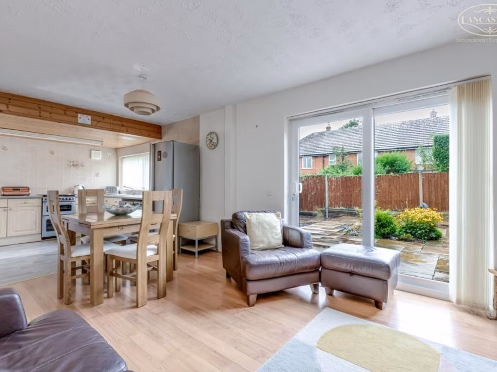
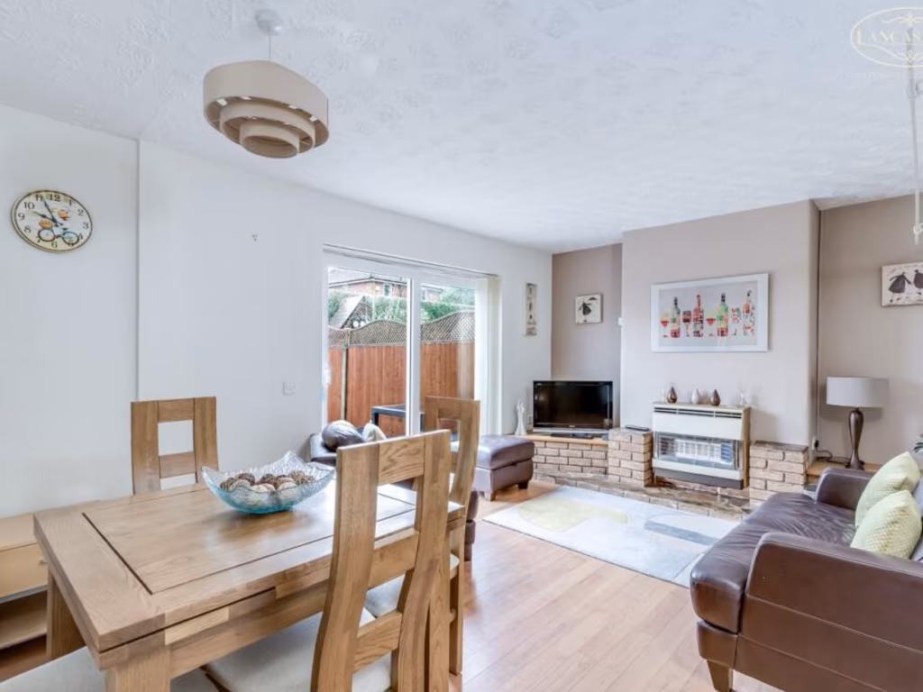
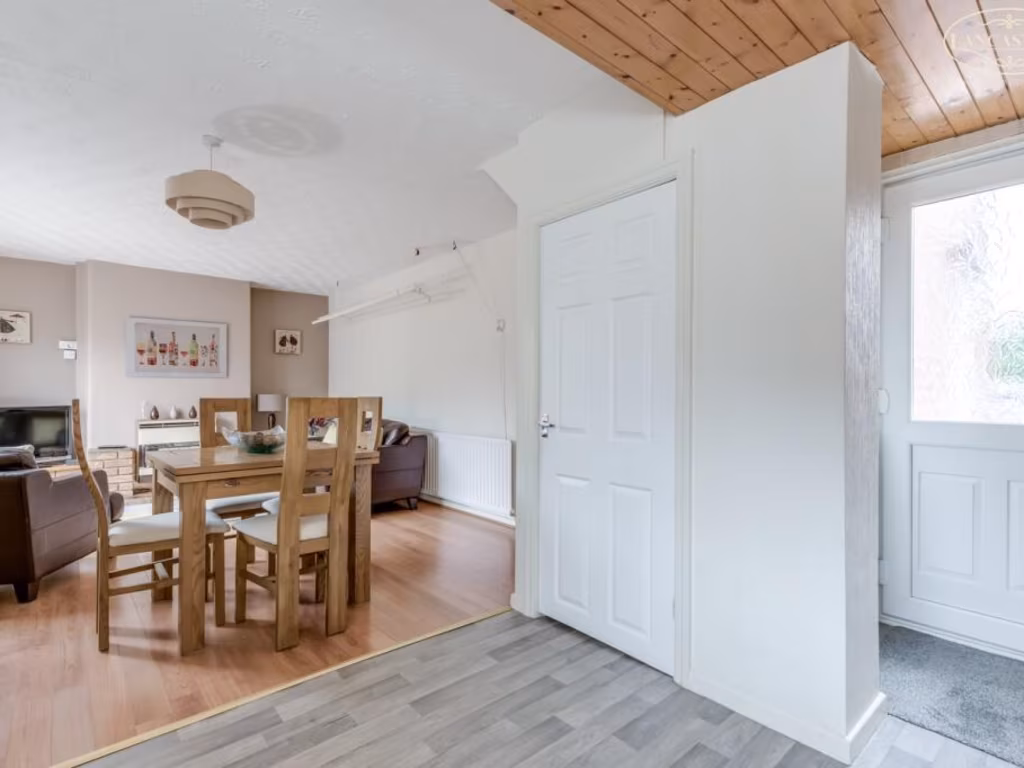
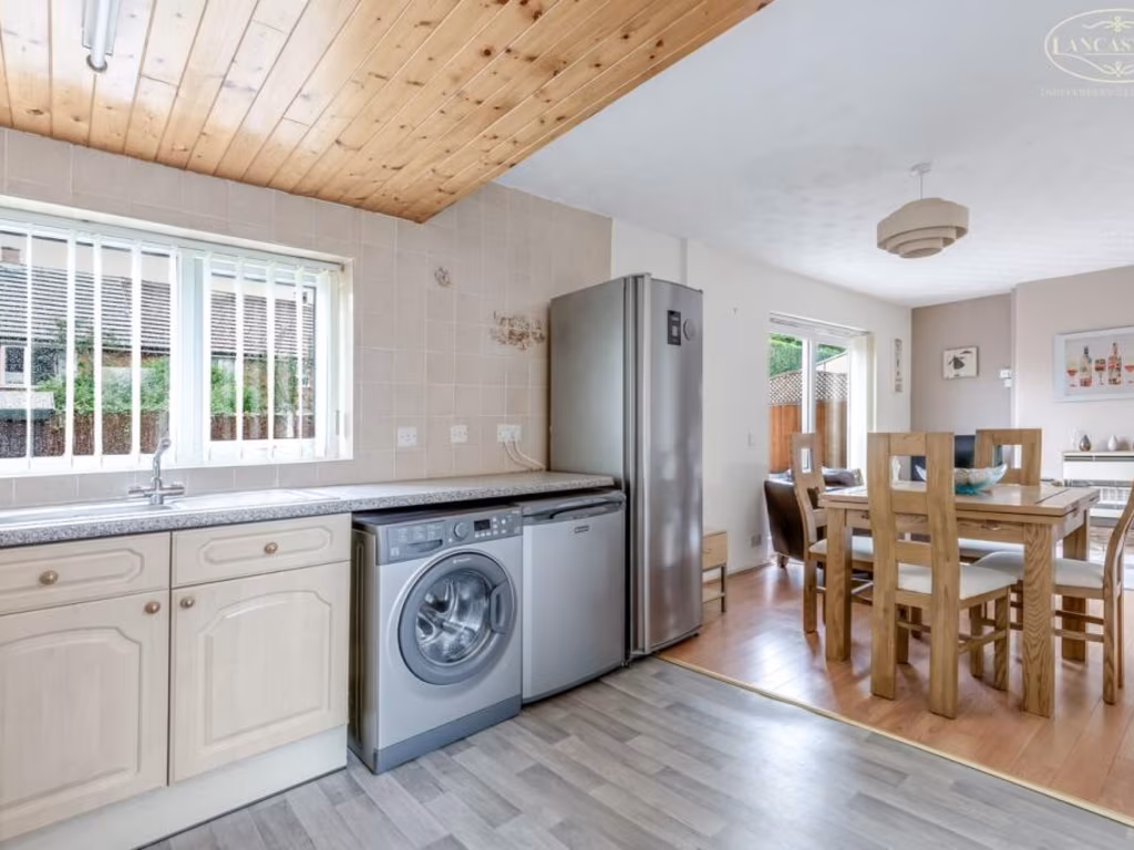
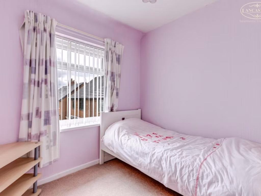
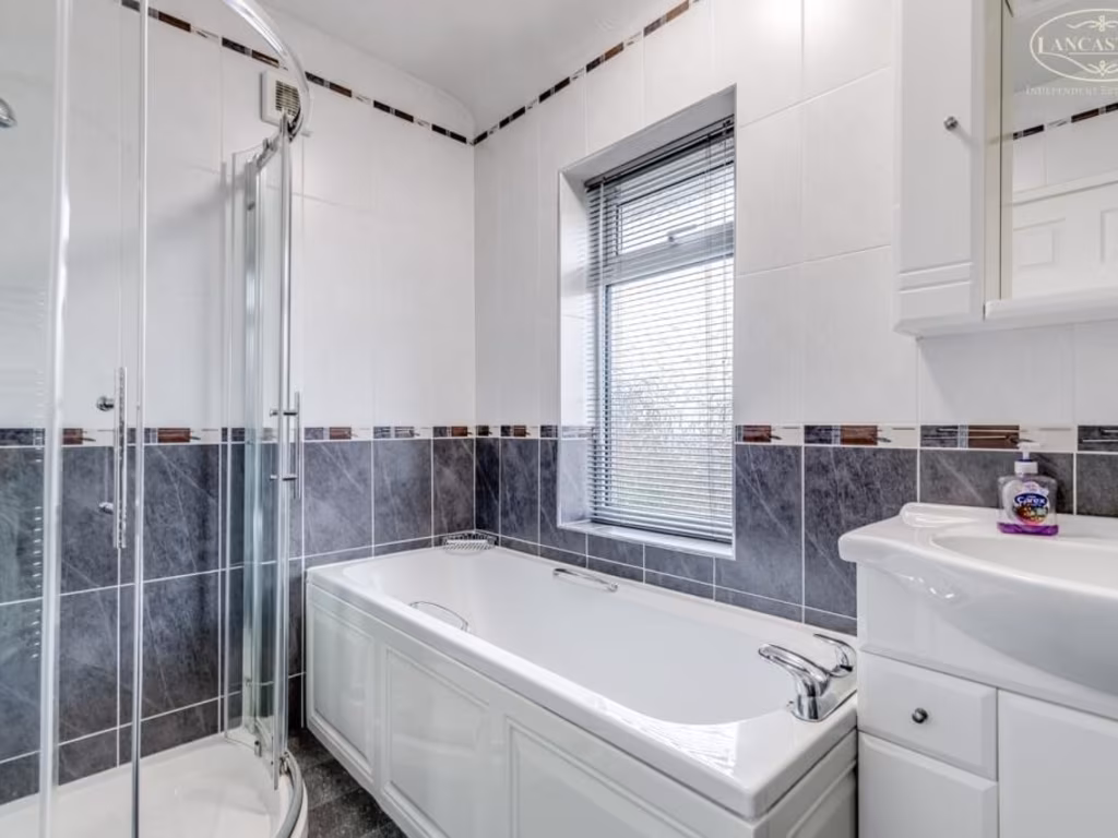
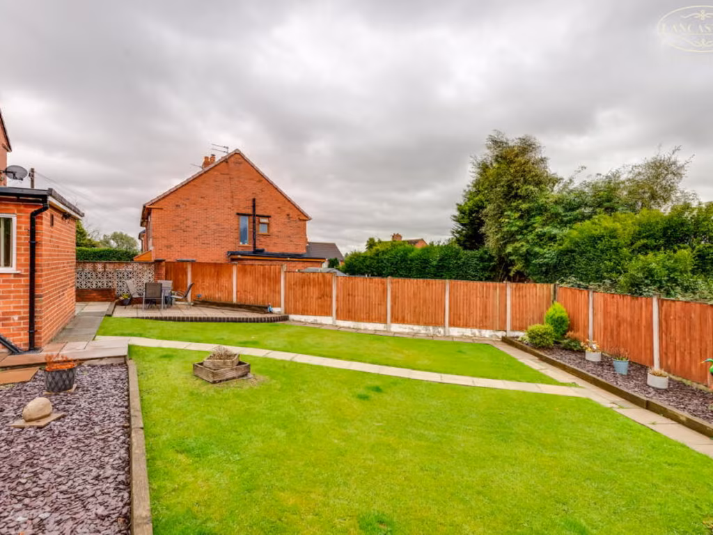
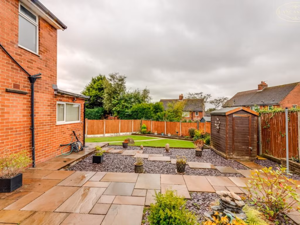
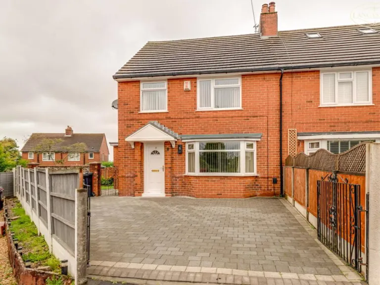
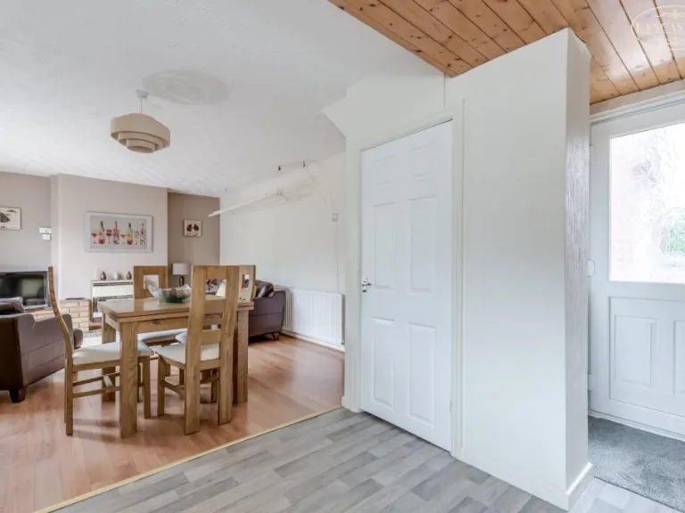
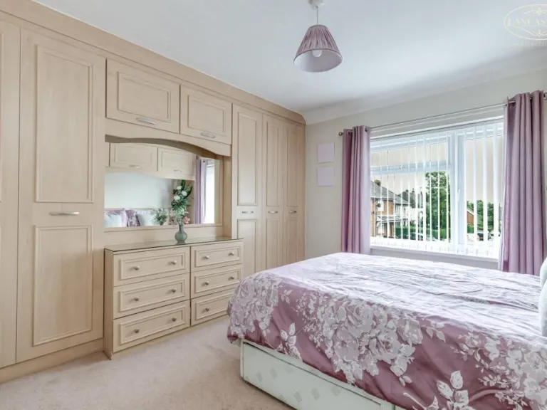
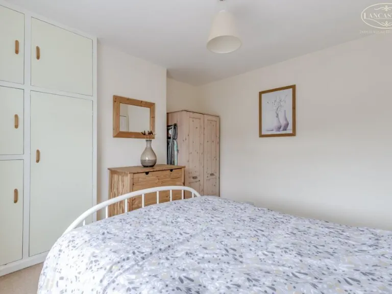
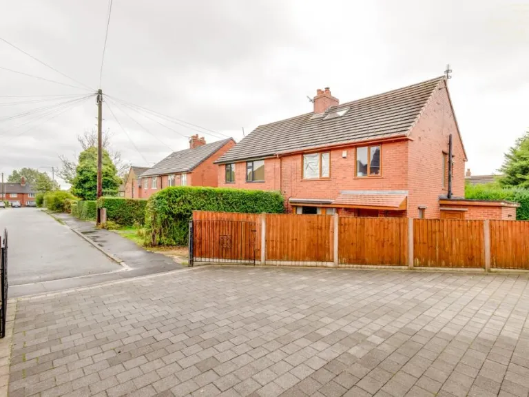
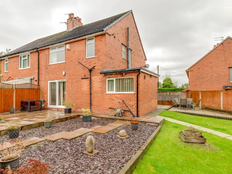
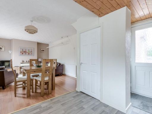
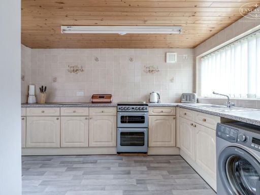
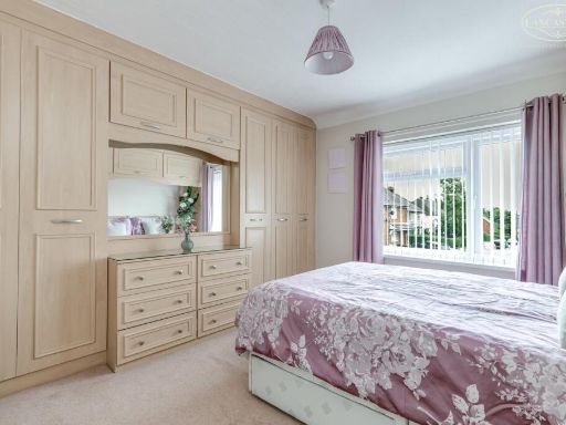
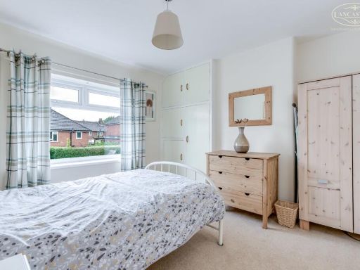
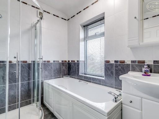
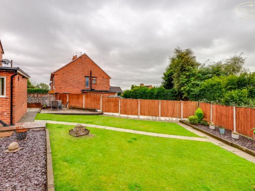
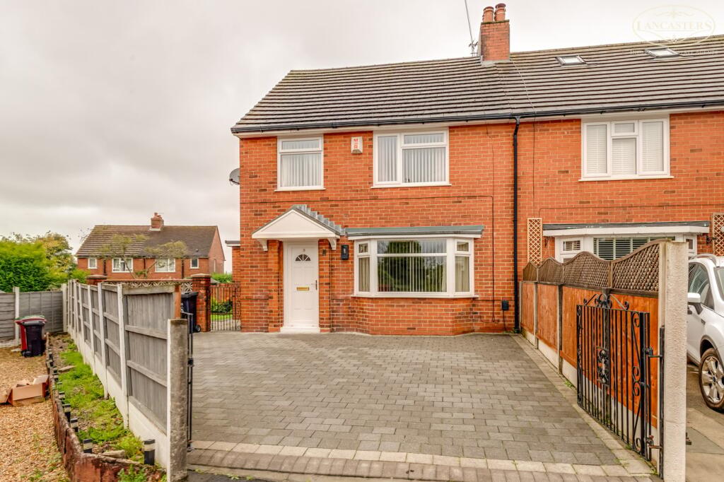
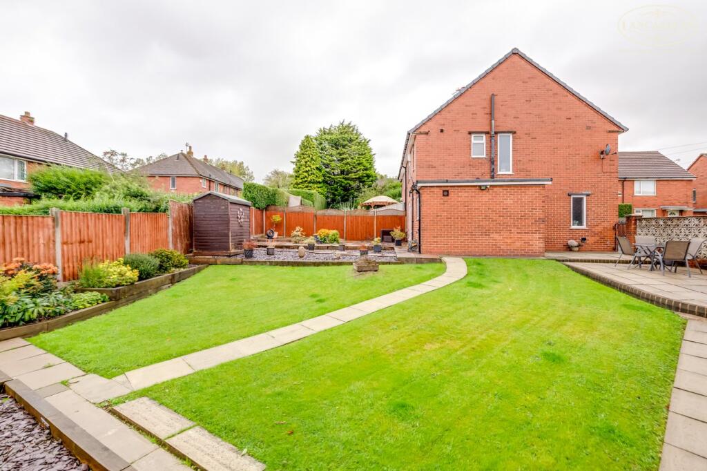
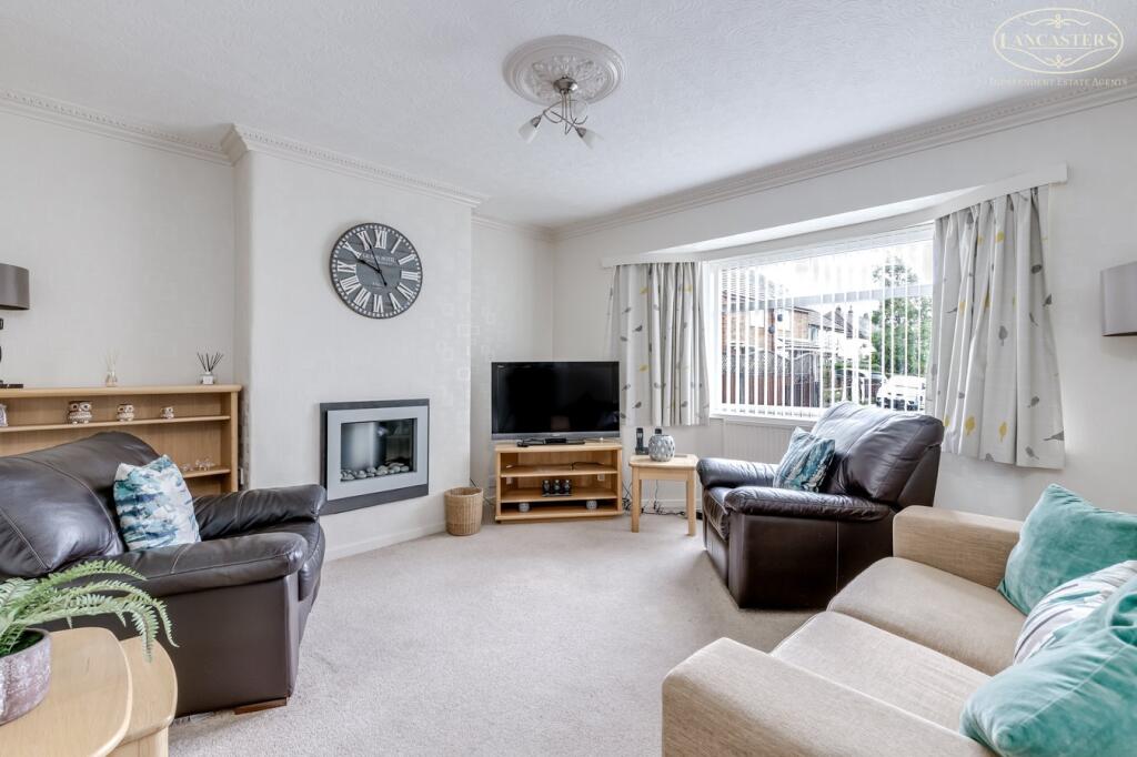
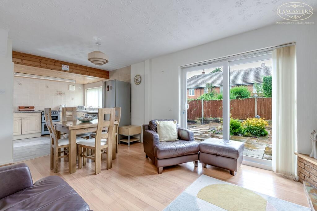
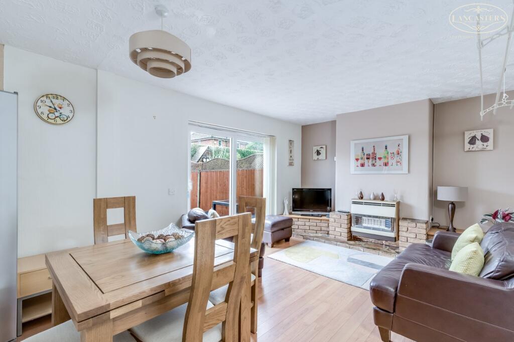
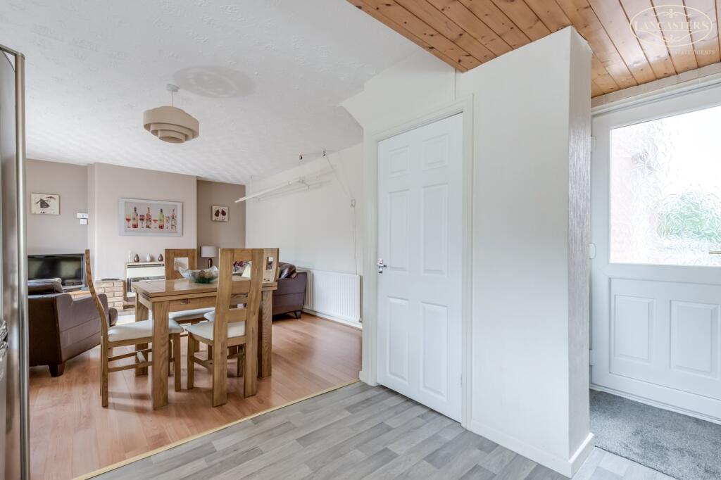
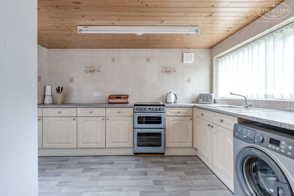
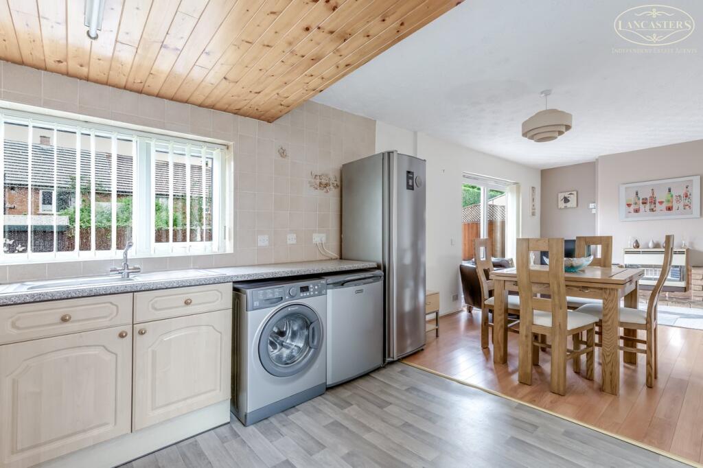
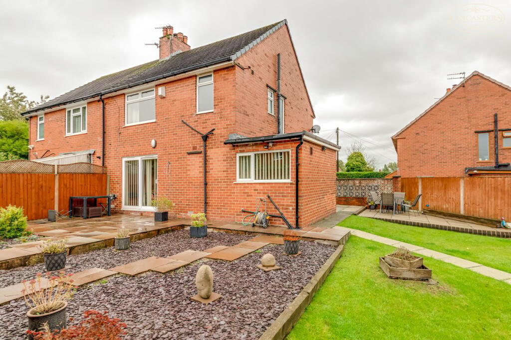
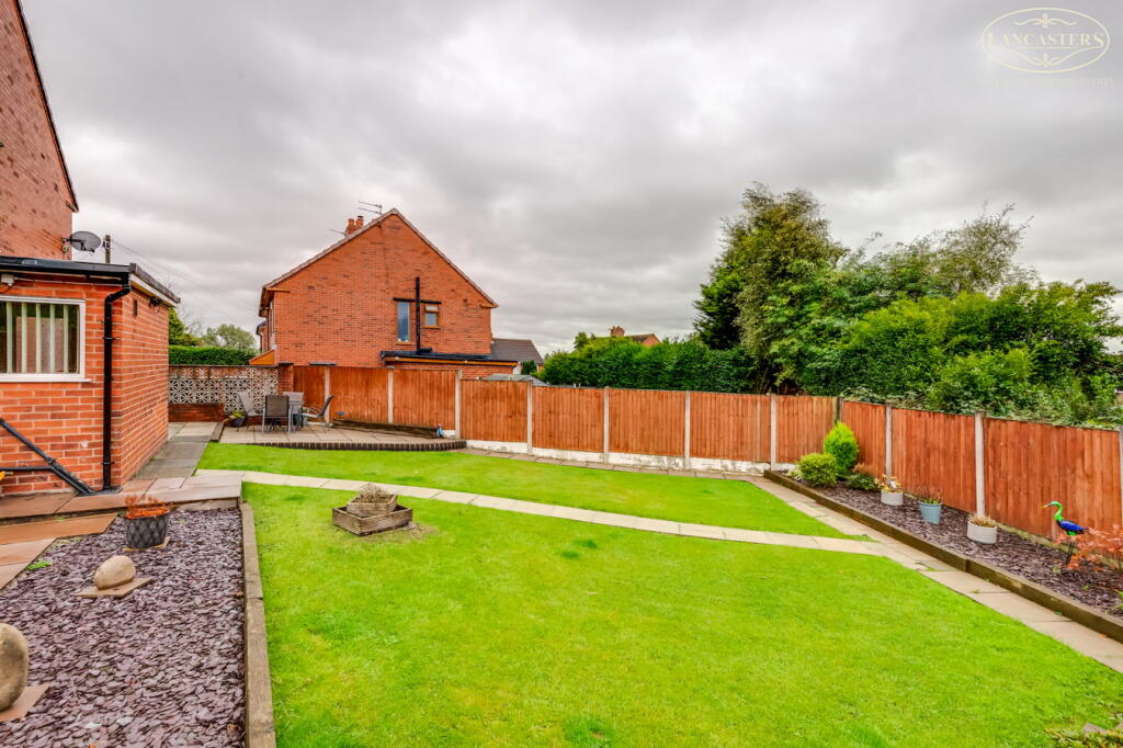
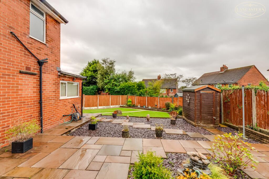
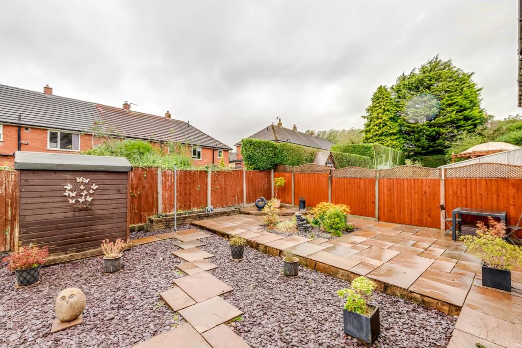
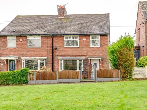
- A well-presented two-storey semi-detached family home located at the head of a quiet cul-de-sac. Constructed in red brick with a pitched tiled roof, the property offers off-street parking via a large paved private driveway and benefits from a sizeable side and rear garden, providing scope for outdoor living and potential extension subject to planning. Internally the accommodation is arranged with a substantial open-plan kitchen/living area to the rear (as noted on the brochure), a front-facing living room with bay window, and upstairs bedrooms served by family bathroom facilities. The property sits in a residential neighbourhood within easy reach of local schools, motorway and train links (c.2.5 miles) and is typical in overall footprint and room proportions for a suburban semi — an average-sized family home presenting good circulation, natural light and practical garden space. Tenure shown as leasehold. No exceptional views are evident from the images.
- Two‑storey, red‑brick semi‑detached family home located at the head of a cul‑de‑sac. Externally the property presents a block‑paved driveway providing off‑street parking for two cars and a small forecourt. Ground floor has a bay‑fronted living room (visible) and the listing notes an open‑plan kitchen/dining area to the rear; interior images show a well presented, neutrally decorated living space. Accommodation is described as three bedrooms (likely two/three bedrooms upstairs). Rear garden is described and appears substantial in size from the listing text and layout; overall the garden can be classed as large. Overall property footprint and rooms are typical of a family semi in the area — rooms are average to generous in size, presentation is good/modern. Cul‑de‑sac location, private driveway and significant rear garden are the primary selling points visible from the images.
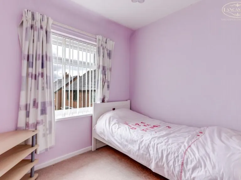
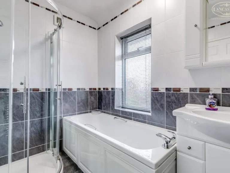
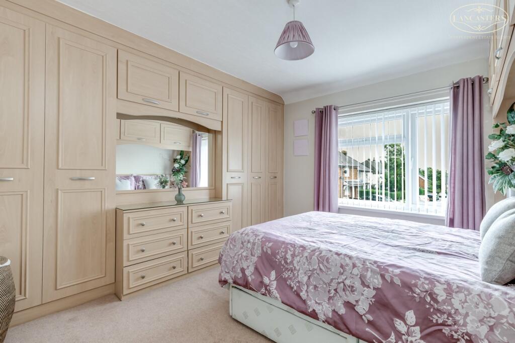
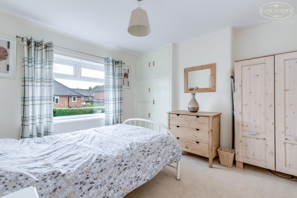
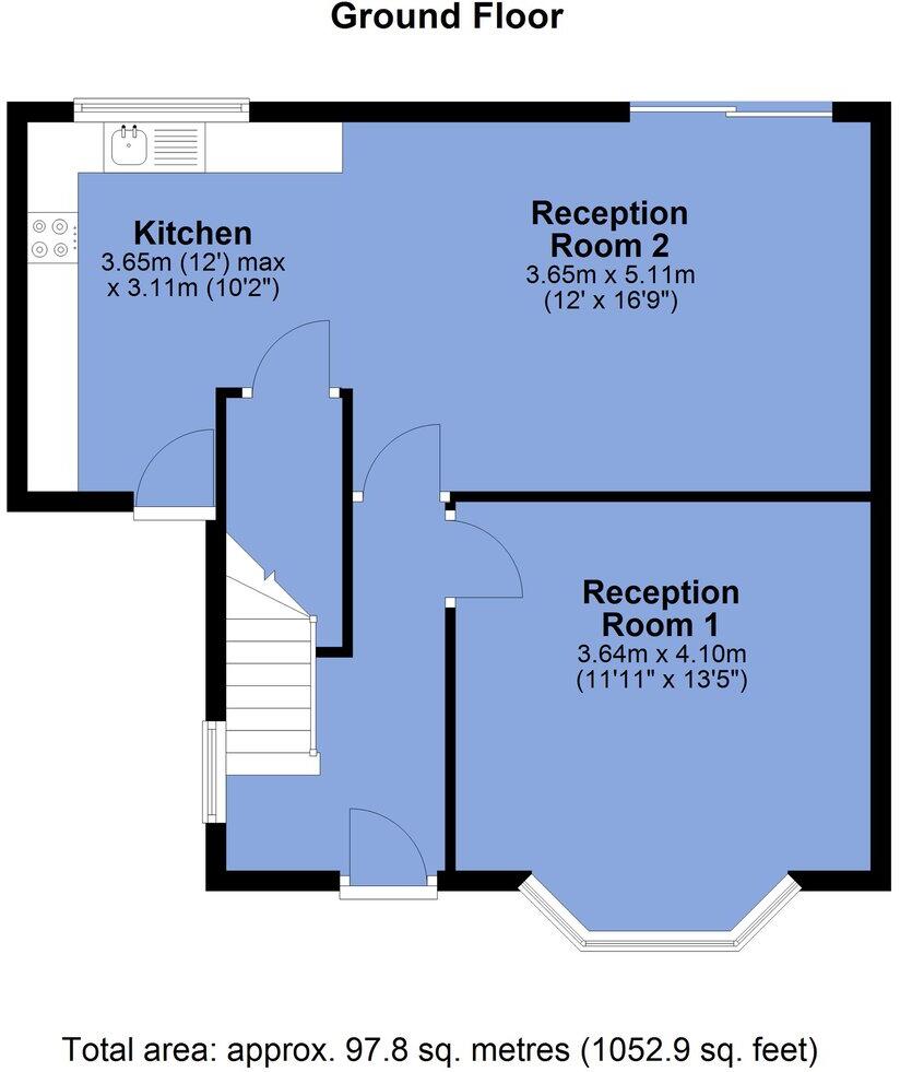
- Single-storey (ground-floor) residential property presented in good, well-maintained condition. Photographs and the floorplan indicate a bungalow-style layout with two reception rooms and a separate kitchen. The accommodation appears to include multiple bedrooms (images show at least three bedrooms), all of average size with built-in storage in one room. Interiors are neutrally presented with carpeted floors and uPVC double-glazed windows; the décor is standard and move-in ready. The floorplan states a total area of approximately 97.8 sq. metres (approx. 1052.9 sq. ft.), placing this as a medium-sized property suitable for a small family or downsizer. Windows look out onto a suburban street/estate (no notable long-distance views). Overall the property offers practical, well-proportioned rooms and good natural light; the layout should appeal to buyers seeking single-level living in a residential neighbourhood.
Image Descriptions
- semi-detached house post-war semi-detached
- backyard Contemporary
Floorplan Description
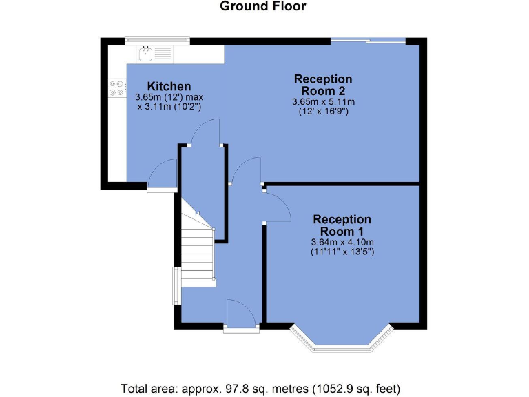
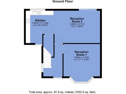
- Ground floor plan showing Kitchen and two Reception Rooms.
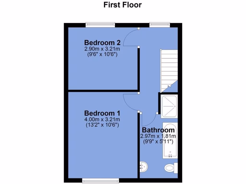
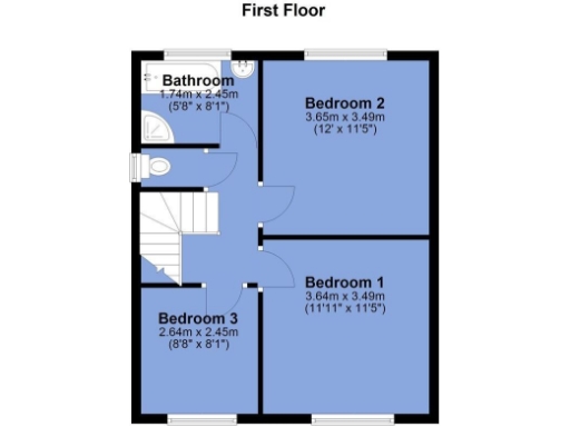
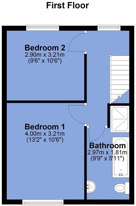
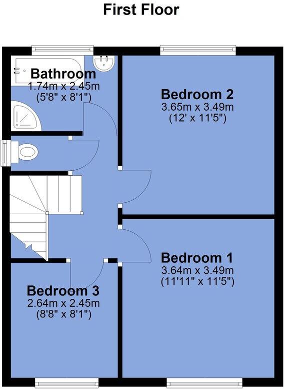
- First Floor plan with three bedrooms and a bathroom.
Rooms
- Kitchen:
- Reception Room 2:
- Reception Room 1:
- Bedroom 2:
- Bedroom 1:
- Bathroom:
- Bathroom:
- Bedroom 2:
- Bedroom 1:
- Bedroom 3:
Textual Property Features
- Has Garden
- Chain Free
- Success
Detected Visual Features
- semi-detached
- post-war
- red brick
- bay window
- driveway
- side entrance
- double glazed
- family home
- suburban
- brick facade
- modern
- well-maintained
- garden
- patio
- shed
- privacy fence
EPC Details
- Fully double glazed
- Cavity wall, filled cavity
- Boiler and radiators, mains gas
- Low energy lighting in 56% of fixed outlets
- Solid, no insulation (assumed)
Nearby Schools
- Beaumont Primary School
- St George's CofE Primary School
- Sacred Heart R.C. Primary School
- St Joseph's RC High School
- Horwich Parish CofE Primary School
- Beacon Primary School
- St James CofE Primary School, Daisy Hill
- Aspull Church Primary School
- Blackrod Primary School
- St Mary's RC Primary School
- Blackrod Anglican/Methodist Primary School
- St Catherine's CofE Primary School
- Rivington and Blackrod High School
- Lostock Primary School
- Markland Hill Primary School
- Johnson Fold Community Primary School
- Eatock Primary School
- Westhoughton High School
- St Bernard's RC Primary School, Bolton
- Ladybridge Community Primary School
- Clevelands Prep School
- St Bartholomew's CofE Primary School
- St Thomas CofE Primary School
- The Gates Primary School
- Claypool Primary School
- Chorley New Road Primary Academy
- Rivington Foundation Primary School
Nearest General Shops
- Id: 663137712
- Tags:
- Addr:
- Housenumber: 565
- Postcode: BL6 6JZ
- Street: Chorley New Road
- Building: yes
- Shop: vacant
- TagsNormalized:
- Lat: 53.5895182
- Lon: -2.5336456
- FullGeoHash: gcw0y7ej9f0z
- PartitionGeoHash: gcw0
- Images:
- FoodStandards: null
- Distance: 247.2
,- Id: 663130423
- Tags:
- Brand: Barnardo's
- Brand:wikidata: Q2884670
- Brand:wikipedia: en:Barnardo's
- Building: yes
- Name: Barnardo's
- Shop: charity
- TagsNormalized:
- Lat: 53.5894392
- Lon: -2.5331563
- FullGeoHash: gcw0y7emj5tb
- PartitionGeoHash: gcw0
- Images:
- FoodStandards: null
- Distance: 233.4
,- Id: 663130430
- Tags:
- Addr:
- Housenumber: 567
- Postcode: BL6 6JZ
- Street: Chorley New Road
- Brand: Greenhalgh's
- Brand:wikidata: Q99939079
- Building: yes
- Fhrs:
- Name: Greenhalgh's
- Shop: bakery
- Source:
- Takeaway: yes
- TagsNormalized:
- Lat: 53.5893712
- Lon: -2.532986
- FullGeoHash: gcw0y7es9nud
- PartitionGeoHash: gcw0
- Images:
- FoodStandards:
- Id: 912280
- FHRSID: 912280
- LocalAuthorityBusinessID: 157585
- BusinessName: Greenhalgh's
- BusinessType: Retailers - other
- BusinessTypeID: 4613
- AddressLine1: Unit 4
- AddressLine2: 567 Chorley New Road
- AddressLine3: Horwich
- AddressLine4: Bolton
- PostCode: BL6 6JZ
- RatingValue: 4
- RatingKey: fhrs_4_en-GB
- RatingDate: 2016-07-27
- LocalAuthorityCode: 403
- LocalAuthorityName: Bolton
- LocalAuthorityWebSite: http://www.bolton.gov.uk
- LocalAuthorityEmailAddress: environmental.health@bolton.gov.uk
- Scores:
- Hygiene: 10
- Structural: 5
- ConfidenceInManagement: 0
- NewRatingPending: false
- Geocode:
- Longitude: -2.53390500000000
- Latitude: 53.58959800000000
- Distance: 233.3
}
Nearest Grocery shops
- Id: 666677897
- Tags:
- Addr:
- Housenumber: 347
- Postcode: BL6 5PP
- Street: Chorley New Road
- Building: yes
- Name: Deano's
- Shop: convenience
- TagsNormalized:
- Lat: 53.5927296
- Lon: -2.5419181
- FullGeoHash: gcw0yhm030bk
- PartitionGeoHash: gcw0
- Images:
- FoodStandards: null
- Distance: 736.5
,- Id: 665786900
- Tags:
- Addr:
- Housenumber: 349
- Postcode: BL6 6DT
- Street: Chorley New Road
- Brand: Premier
- Brand:wikidata: Q7240340
- Brand:wikipedia: en:Premier Stores
- Building: yes
- Fhrs:
- Name: Premier
- Phone: +44 1204 692489
- Shop: convenience
- TagsNormalized:
- Lat: 53.5926247
- Lon: -2.5415871
- FullGeoHash: gcw0yhjr8tr6
- PartitionGeoHash: gcw0
- Images:
- FoodStandards:
- Id: 594406
- FHRSID: 594406
- LocalAuthorityBusinessID: 151189
- BusinessName: Premier
- BusinessType: Retailers - other
- BusinessTypeID: 4613
- AddressLine1: null
- AddressLine2: 349 Chorley New Road
- AddressLine3: Horwich
- AddressLine4: Bolton
- PostCode: BL6 6DT
- RatingValue: 3
- RatingKey: fhrs_3_en-GB
- RatingDate: 2014-07-29
- LocalAuthorityCode: 403
- LocalAuthorityName: Bolton
- LocalAuthorityWebSite: http://www.bolton.gov.uk
- LocalAuthorityEmailAddress: environmental.health@bolton.gov.uk
- Scores:
- Hygiene: 10
- Structural: 10
- ConfidenceInManagement: 10
- NewRatingPending: false
- Geocode:
- Longitude: -2.54005800000000
- Latitude: 53.59223200000000
- Distance: 712.5
,- Id: 577557799
- Tags:
- Addr:
- Housenumber: 427
- Postcode: BL6 6DT
- Street: Chorley New Road
- Brand: Texaco
- Brand:wikidata: Q775060
- Building: yes
- Name: Texaco
- Shop: convenience
- Website: https://locations.valero.com/en-us/LocationDetails/Index/427-CHORLEY-NEW-RD/0000259867
- TagsNormalized:
- Lat: 53.5917201
- Lon: -2.5386764
- FullGeoHash: gcw0yhp6ks9w
- PartitionGeoHash: gcw0
- Images:
- FoodStandards: null
- Distance: 505.2
}
Nearest Religious buildings
- Id: 662806840
- Tags:
- Addr:
- Postcode: BL6 6QN
- Street: New Chapel Lane
- Amenity: place_of_worship
- Building: yes
- Fhrs:
- Name: New Chapel United Reformed Church
- Religion: christian
- Source:
- TagsNormalized:
- place of worship
- chapel
- church
- united reformed
- christian
- Lat: 53.5925631
- Lon: -2.5219847
- FullGeoHash: gcw0ys5x33zg
- PartitionGeoHash: gcw0
- Images:
- FoodStandards:
- Id: 52917
- FHRSID: 52917
- LocalAuthorityBusinessID: 11983
- BusinessName: United Reformed Church
- BusinessType: Restaurant/Cafe/Canteen
- BusinessTypeID: 1
- AddressLine1: null
- AddressLine2: New Chapel Lane
- AddressLine3: Horwich
- AddressLine4: Bolton
- PostCode: BL6 6QN
- RatingValue: 4
- RatingKey: fhrs_4_en-GB
- RatingDate: 2016-03-31
- LocalAuthorityCode: 403
- LocalAuthorityName: Bolton
- LocalAuthorityWebSite: http://www.bolton.gov.uk
- LocalAuthorityEmailAddress: environmental.health@bolton.gov.uk
- Scores:
- Hygiene: 0
- Structural: 0
- ConfidenceInManagement: 10
- NewRatingPending: false
- Geocode:
- Longitude: -2.52200800000000
- Latitude: 53.59256400000000
- Distance: 621.1
,- Id: 552411263
- Tags:
- Addr:
- City: Horwich
- Postcode: BL6 6HT
- Street: Cedar Avenue
- Amenity: place_of_worship
- Building: yes
- Denomination: anglican
- Name: St Elizabeth's Church
- Phone: +44 1204 694611
- Religion: christian
- Website: http://www.bhrmp.co.uk/st-elizabeth-horwich/
- Wikidata: Q105100856
- TagsNormalized:
- place of worship
- anglican
- church
- christian
- Lat: 53.5873767
- Lon: -2.5263707
- FullGeoHash: gcw0ye235713
- PartitionGeoHash: gcw0
- Images:
- FoodStandards: null
- Distance: 521.4
,- Id: 552853619
- Tags:
- Amenity: place_of_worship
- Building: yes
- Denomination: methodist
- Name: St John's Methodist Church
- Religion: christian
- TagsNormalized:
- place of worship
- methodist
- church
- christian
- Lat: 53.5930621
- Lon: -2.5376959
- FullGeoHash: gcw0yk245quu
- PartitionGeoHash: gcw0
- Images:
- FoodStandards: null
- Distance: 485.9
}
Nearest Medical buildings
- Id: 7497740743
- Tags:
- Amenity: pharmacy
- Brand: Asda
- Brand:wikidata: Q297410
- Brand:wikipedia: en:Asda
- Contact:
- Phone: +44 1204 699337
- Website: https://storelocator.asda.com/north-west/horwich/43-53-the-linkway/pharmacy
- Healthcare: pharmacy
- Name: Asda
- Operator: Asda Stores Ltd
- TagsNormalized:
- pharmacy
- asda
- health
- healthcare
- Lat: 53.5848241
- Lon: -2.5344454
- FullGeoHash: gcw0y6f6pphw
- PartitionGeoHash: gcw0
- Images:
- FoodStandards: null
- Distance: 736.5
,- Id: 507404821
- Tags:
- Amenity: pharmacy
- Brand: Boots
- Brand:wikidata: Q6123139
- Brand:wikipedia: en:Boots (company)
- Building: yes
- Healthcare: pharmacy
- Name: Boots
- TagsNormalized:
- pharmacy
- boots
- health
- healthcare
- Lat: 53.5852711
- Lon: -2.5359224
- FullGeoHash: gcw0y6ckudx0
- PartitionGeoHash: gcw0
- Images:
- FoodStandards: null
- Distance: 726.5
,- Id: 552411264
- Tags:
- Addr:
- City: Horwich
- Postcode: BL6 6LH
- Street: Chorley New Road
- Amenity: social_facility
- Healthcare: nursing_home
- Name: Swallowfield Gardens
- Social_facility: nursing_home
- Social_facility:for: senior
- Website: https://cuerden.com/center/swallowfield-gardens/
- TagsNormalized:
- social facility
- nursing home
- health
- healthcare
- Lat: 53.5872686
- Lon: -2.5280712
- FullGeoHash: gcw0y7r07wvk
- PartitionGeoHash: gcw0
- Images:
- FoodStandards: null
- Distance: 474.2
,- Id: 663143366
- Tags:
- Addr:
- Housenumber: 517
- Postcode: BL6 6JT
- Street: Chorley New Road
- Amenity: dentist
- Building: yes
- Healthcare: dentist
- Name: Horwich Dental Care Centre
- TagsNormalized:
- dentist
- health
- healthcare
- dental
- Lat: 53.5901063
- Lon: -2.5352778
- FullGeoHash: gcw0y7cbgxzu
- PartitionGeoHash: gcw0
- Images:
- FoodStandards: null
- Distance: 299.7
}
Nearest Airports
- Id: 116737532
- Tags:
- Addr:
- City: Liverpool
- Country: GB
- Postcode: L24 1YD
- Street: Speke Hall Avenue
- Aerodrome: international
- Aerodrome:type: public
- Aeroway: aerodrome
- Iata: LPL
- Icao: EGGP
- Is_in: Liverpool,England,UK
- Name: Liverpool John Lennon Airport
- Old_name: Speke Airport
- Operator: Liverpool Airport plc
- Source: wikipedia
- Website: https://www.liverpoolairport.com/
- Wikidata: Q8727
- Wikipedia: en:Liverpool John Lennon Airport
- TagsNormalized:
- airport
- international airport
- Lat: 53.3357677
- Lon: -2.8518179
- FullGeoHash: gcmzrj7r7gdr
- PartitionGeoHash: gcmz
- Images:
- FoodStandards: null
- Distance: 35456
,- Id: 1224469
- Tags:
- Addr:
- City: Manchester
- Country: GB
- Postcode: M90 1QX
- Aerodrome: international
- Aeroway: aerodrome
- Arp: yes
- Atis: 128.175
- Iata: MAN
- Icao: EGCC
- Name: Manchester Airport
- Note: rough sketched outline referring to Yahoo imagery - true boundary is where?
- Old_name: Ringway
- Operator: Manchester Airport PLC
- Size: 18720000
- Source:
- Tower_frequency: 118.625,119.400
- Type: multipolygon
- Website: https://www.manchesterairport.co.uk/
- Wikidata: Q8694
- Wikipedia: en:Manchester Airport
- TagsNormalized:
- airport
- international airport
- Lat: 53.3503197
- Lon: -2.2798822
- FullGeoHash: gcqrs05u4ukt
- PartitionGeoHash: gcqr
- Images:
- FoodStandards: null
- Distance: 31519.7
}
Nearest Leisure Facilities
- Id: 6128815864
- Tags:
- TagsNormalized:
- Lat: 53.5870191
- Lon: -2.533454
- FullGeoHash: gcw0y75pn0ru
- PartitionGeoHash: gcw0
- Images:
- FoodStandards: null
- Distance: 484.2
,- Id: 654014248
- Tags:
- TagsNormalized:
- Lat: 53.5875797
- Lon: -2.5338972
- FullGeoHash: gcw0y76f7bvk
- PartitionGeoHash: gcw0
- Images:
- FoodStandards: null
- Distance: 437.2
,- Id: 9217210
- Tags:
- Leisure: park
- Type: multipolygon
- TagsNormalized:
- Lat: 53.5875917
- Lon: -2.5338873
- FullGeoHash: gcw0y76fk5he
- PartitionGeoHash: gcw0
- Images:
- FoodStandards: null
- Distance: 435.8
,- Id: 398553233
- Tags:
- Addr:
- City: Horwich
- Postcode: BL6 5PH
- Street: Victoria Road
- Description: 18 hole Par 67
- Golf:
- Leisure: golf_course
- Name: Horwich Golf Club
- Phone: +44 1204 696980
- Website: http://www.horwichgolfclub.co.uk/
- TagsNormalized:
- golf
- golf course
- leisure
- club
- Lat: 53.5941471
- Lon: -2.5346251
- FullGeoHash: gcw0ykd2dcns
- PartitionGeoHash: gcw0
- Images:
- FoodStandards: null
- Distance: 407.9
,- Id: 663119677
- Tags:
- TagsNormalized:
- Lat: 53.5896968
- Lon: -2.5274873
- FullGeoHash: gcw0y7xw978c
- PartitionGeoHash: gcw0
- Images:
- FoodStandards: null
- Distance: 286.6
}
Nearest Tourist attractions
- Id: 659476748
- Tags:
- Addr:
- City: Westhoughton
- Housenumber: 338
- Postcode: BL5 3QE
- Street: Church Street
- Building: yes
- Email: whitewallgallery@hotmail.com
- Name: The White Wall gallery & Framers
- Tourism: gallery
- Website: https://thewhitewallgalleryandframers.com/
- TagsNormalized:
- Lat: 53.559578
- Lon: -2.5242503
- FullGeoHash: gcw0ww1zhsyx
- PartitionGeoHash: gcw0
- Images:
- FoodStandards: null
- Distance: 3538.4
,- Id: 664168840
- Tags:
- Tourism: trail_riding_station
- TagsNormalized:
- Lat: 53.6053639
- Lon: -2.4976294
- FullGeoHash: gcw0znt3ch0e
- PartitionGeoHash: gcw0
- Images:
- FoodStandards: null
- Distance: 2715.7
,- Id: 665303873
- Tags:
- Building: yes
- Name: Horwich Heritage Centre
- Tourism: museum
- Website: https://www.horwichheritage.co.uk/
- Wikidata: Q113454681
- TagsNormalized:
- Lat: 53.6005647
- Lon: -2.544255
- FullGeoHash: gcw0yjemft3y
- PartitionGeoHash: gcw0
- Images:
- FoodStandards: null
- Distance: 1361.5
}
Nearest Train stations
- Id: 2606101574
- Tags:
- Name: Walker Gardens
- Network: Haigh Woodland Park Miniature Railway
- Operator: Wigan District Model Engineering Society
- Public_transport: station
- Railway: station
- Usage: tourism
- TagsNormalized:
- Lat: 53.5712017
- Lon: -2.6032062
- FullGeoHash: gcw0ub26uguc
- PartitionGeoHash: gcw0
- Images:
- FoodStandards: null
- Distance: 5252
,- Id: 6178577209
- Tags:
- Name: Westhoughton
- Naptan:
- Network: National Rail
- Public_transport: station
- Railway: station
- Ref:
- Source: npe
- Wikidata: Q2751556
- Wikipedia: en:Westhoughton railway station
- TagsNormalized:
- Lat: 53.5558849
- Lon: -2.523221
- FullGeoHash: gcw0wtd9ssw1
- PartitionGeoHash: gcw0
- Images:
- FoodStandards: null
- Distance: 3954.4
,- Id: 5392831639
- Tags:
- Name: Lostock
- Naptan:
- Network: National Rail
- Operator: Northern Rail
- Public_transport: station
- Railway: station
- Ref:
- Train: yes
- Wikidata: Q6684520
- Wikipedia: en:Lostock railway station
- TagsNormalized:
- Lat: 53.5727921
- Lon: -2.494764
- FullGeoHash: gcw0z0xk5u30
- PartitionGeoHash: gcw0
- Images:
- FoodStandards: null
- Distance: 3148.2
,- Id: 22404971
- Tags:
- Air_conditioning: no
- Internet_access: no
- Name: Blackrod
- Naptan:
- Network: National Rail
- Operator: Northern Rail
- Public_transport: station
- Railway: station
- Ref:
- Train: yes
- Wheelchair: yes
- Wikidata: Q1820371
- Wikipedia: en:Blackrod railway station
- TagsNormalized:
- Lat: 53.5912146
- Lon: -2.5698672
- FullGeoHash: gcw0vebxmy2p
- PartitionGeoHash: gcw0
- Images:
- FoodStandards: null
- Distance: 2559.6
,- Id: 6212935276
- Tags:
- Name: Horwich Parkway
- Naptan:
- Network: National Rail
- Public_transport: station
- Railway: station
- Ref:
- Wikidata: Q2707094
- Wikipedia: en:Horwich Parkway railway station
- TagsNormalized:
- Lat: 53.5779831
- Lon: -2.5397317
- FullGeoHash: gcw0y1wd7gyy
- PartitionGeoHash: gcw0
- Images:
- FoodStandards: null
- Distance: 1570.4
}
Nearest Hotels
- Id: 32940496
- Tags:
- Addr:
- Housenumber: 3
- Postcode: BL6 6LB
- Street: Arena Approach
- Brand: Premier Inn
- Brand:wikidata: Q2108626
- Brand:wikipedia: en:Premier Inn
- Building: yes
- Fhrs:
- Internet_access: wlan
- Internet_access:fee: customers
- Internet_access:operator: Virgin Media
- Internet_access:ssid: Premier Inn Free Wi-Fi
- Name: Premier Inn
- Source:
- Tourism: hotel
- TagsNormalized:
- Lat: 53.5787225
- Lon: -2.5380856
- FullGeoHash: gcw0y1xydmf1
- PartitionGeoHash: gcw0
- Images:
- FoodStandards: null
- Distance: 1456
,- Id: 467049486
- Tags:
- Name: Bolton Whites
- Tourism: hotel
- TagsNormalized:
- Lat: 53.5798877
- Lon: -2.5343319
- FullGeoHash: gcw0y3ft3ycp
- PartitionGeoHash: gcw0
- Images:
- FoodStandards: null
- Distance: 1269.4
,- Id: 657589464
- Tags:
- Addr:
- Housenumber: 989
- Postcode: BL6 4BA
- Street: Chorley New Road
- Brand: Premier Inn
- Brand:wikidata: Q2108626
- Brand:wikipedia: en:Premier Inn
- Building: yes
- Internet_access: wlan
- Internet_access:fee: customers
- Internet_access:operator: Virgin Media
- Internet_access:ssid: Premier Inn Free Wi-Fi
- Name: Premier Inn
- Tourism: hotel
- TagsNormalized:
- Lat: 53.5849241
- Lon: -2.5224399
- FullGeoHash: gcw0ydg4ycu7
- PartitionGeoHash: gcw0
- Images:
- FoodStandards: null
- Distance: 896.3
}
Tags
- semi-detached
- post-war
- red brick
- bay window
- driveway
- side entrance
- double glazed
- family home
- suburban
- brick facade
- red brick
- modern
- well-maintained
- garden
- patio
- shed
- privacy fence
Local Market Stats
- Average Price/sqft: £219
- Avg Income: £42700
- Rental Yield: 4%
- Social Housing: 3%
- Planning Success Rate: 87%
AirBnB Data
- 1km average: £71/night
- Listings in 1km: 1
Similar Properties
 3 bedroom semi-detached house for sale in Makinson Avenue, Horwich, Bolton, BL6 — £202,000 • 3 bed • 1 bath
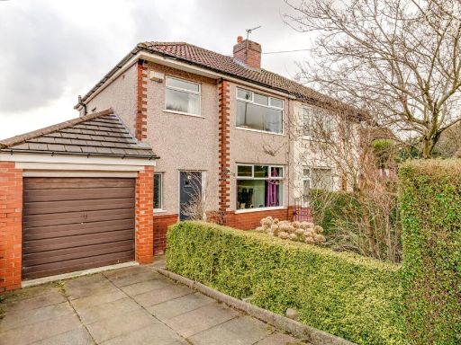 3 bedroom semi-detached house for sale in Highland Road, Horwich, Bolton, BL6 — £185,000 • 3 bed • 1 bath • 875 ft²
 2 bedroom semi-detached house for sale in Broomfield Close, Ainsworth, Bolton, Greater Manchester, BL2 5QY, BL2 — £240,000 • 2 bed • 1 bath • 818 ft²
 4 bedroom semi-detached house for sale in Ridgmont Drive, Horwich, Bolton, BL6 — £650,000 • 4 bed • 2 bath • 2100 ft²
 3 bedroom semi-detached house for sale in Salford Road, Bolton, BL5 — £275,000 • 3 bed • 1 bath • 1044 ft²
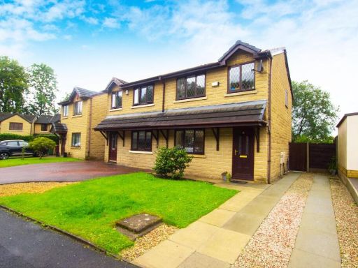 3 bedroom semi-detached house for sale in Hypatia Street, Bolton, BL2 — £220,000 • 3 bed • 1 bath • 731 ft²
Meta
- {
"@context": "https://schema.org",
"@type": "Residence",
"name": "3 bedroom semidetached house for sale in Lancaster Avenue,…",
"description": "",
"url": "https://propertypiper.co.uk/property/a1b353ef-99ba-4f85-8c2c-9106a831b125",
"image": "https://image-a.propertypiper.co.uk/8e6177df-541f-4fad-ad48-c4763f5ad678-1024.jpeg",
"address": {
"@type": "PostalAddress",
"streetAddress": "26, Lancaster Avenue, Horwich",
"postalCode": "BL6 6ND",
"addressLocality": "Bolton",
"addressRegion": "Bolton West",
"addressCountry": "England"
},
"geo": {
"@type": "GeoCoordinates",
"latitude": 53.5911399597433,
"longitude": -2.5310847151866716
},
"numberOfRooms": 3,
"numberOfBathroomsTotal": 1,
"floorSize": {
"@type": "QuantitativeValue",
"value": 1052,
"unitCode": "FTK"
},
"offers": {
"@type": "Offer",
"price": 225000,
"priceCurrency": "GBP",
"availability": "https://schema.org/InStock"
},
"additionalProperty": [
{
"@type": "PropertyValue",
"name": "Feature",
"value": "semi-detached"
},
{
"@type": "PropertyValue",
"name": "Feature",
"value": "post-war"
},
{
"@type": "PropertyValue",
"name": "Feature",
"value": "red brick"
},
{
"@type": "PropertyValue",
"name": "Feature",
"value": "bay window"
},
{
"@type": "PropertyValue",
"name": "Feature",
"value": "driveway"
},
{
"@type": "PropertyValue",
"name": "Feature",
"value": "side entrance"
},
{
"@type": "PropertyValue",
"name": "Feature",
"value": "double glazed"
},
{
"@type": "PropertyValue",
"name": "Feature",
"value": "family home"
},
{
"@type": "PropertyValue",
"name": "Feature",
"value": "suburban"
},
{
"@type": "PropertyValue",
"name": "Feature",
"value": "brick facade"
},
{
"@type": "PropertyValue",
"name": "Feature",
"value": "red brick"
},
{
"@type": "PropertyValue",
"name": "Feature",
"value": "modern"
},
{
"@type": "PropertyValue",
"name": "Feature",
"value": "well-maintained"
},
{
"@type": "PropertyValue",
"name": "Feature",
"value": "garden"
},
{
"@type": "PropertyValue",
"name": "Feature",
"value": "patio"
},
{
"@type": "PropertyValue",
"name": "Feature",
"value": "shed"
},
{
"@type": "PropertyValue",
"name": "Feature",
"value": "privacy fence"
}
]
}
High Res Floorplan Images
Compatible Floorplan Images
FloorplanImages Thumbnail