SY5 9RN - Detached house for sale in Blackmore, Westbury, Shrewsbury,…
View on Property Piper
Detached house for sale in Blackmore, Westbury, Shrewsbury, SY5
Property Details
- Price: £265000
- Bedrooms: 1
- Bathrooms: 1
- Property Type: undefined
- Property SubType: undefined
Brochure Descriptions
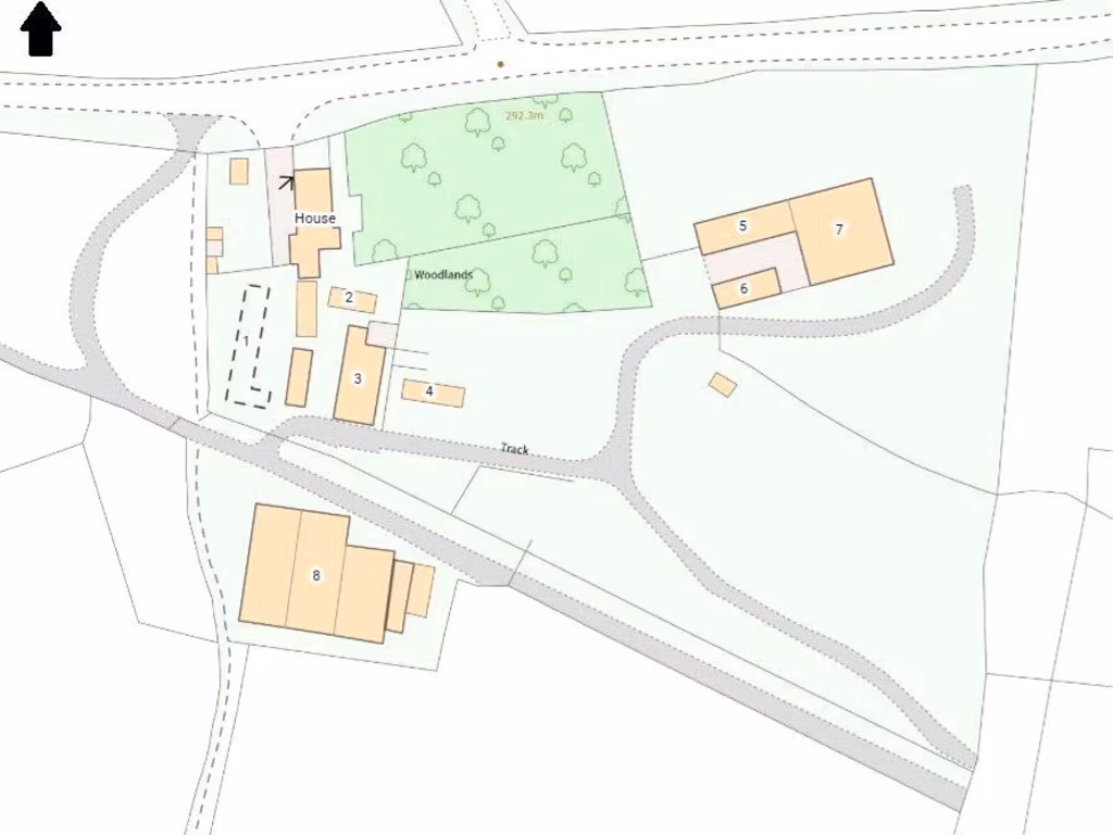
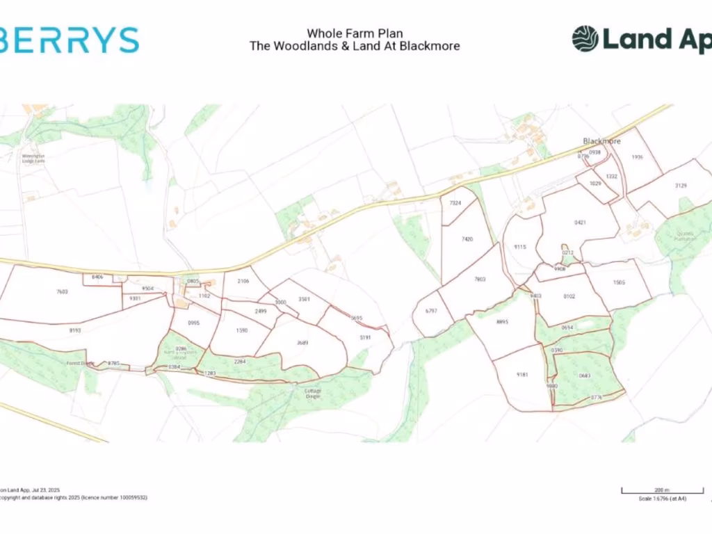
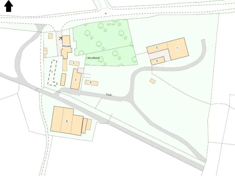
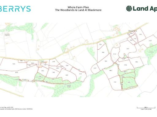
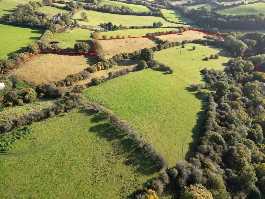
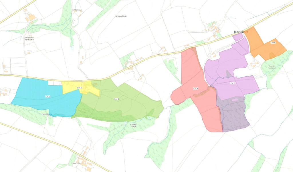
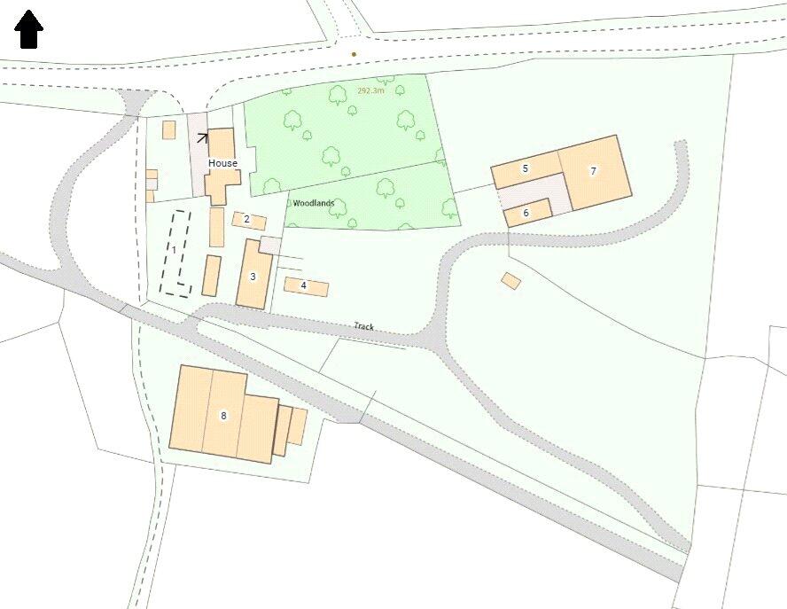
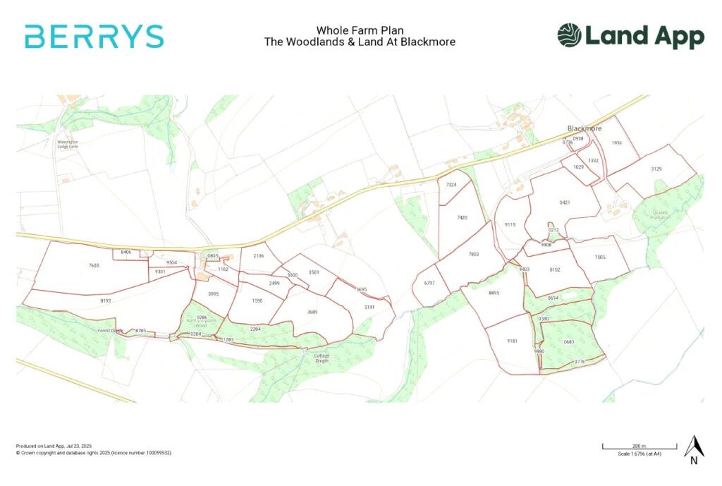
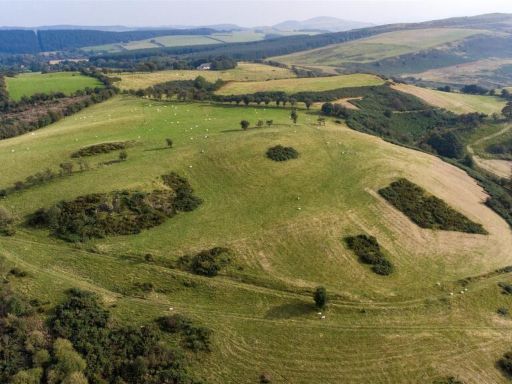
- Large rural holding comprising mixed pasture, woodland and hedged paddocks accessed by a private lane. The land is irregularly shaped and extends over rolling countryside with good natural shelter belts and mature tree cover. A small cluster of buildings/possible farmhouse is visible near the access, with surrounding yard and outbuildings. The topography is gently undulating with long views across open agricultural land; boundaries appear to be hedgerows and tree lines. Overall the property reads as a large agricultural/amenity estate suitable for grazing, small-scale forestry and equestrian use. Parcel sizes vary from small paddocks to large fields; overall property size is substantial (large/huge), but no precise area or internal floor area is shown on the image.
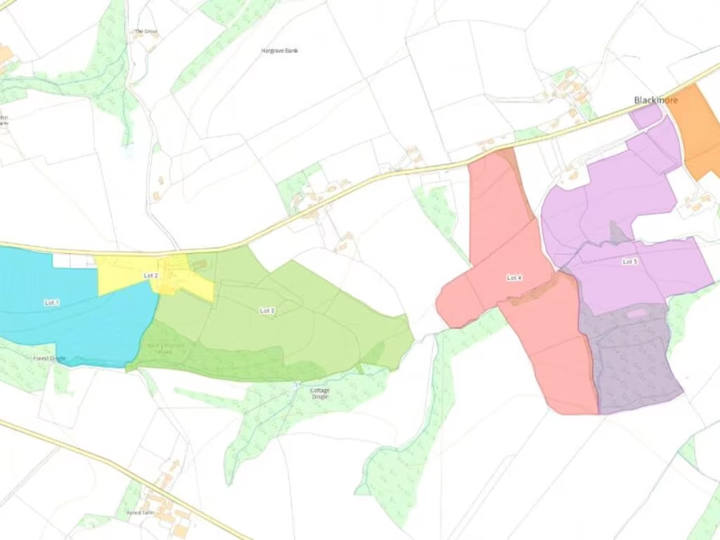
- Rural land parcel offered for sale as freehold (shown on an Ordnance Survey map with the lot circled). Access directions reference Shrewsbury → B4386 → Westbury → Vennington → Vron Gate and indicate the land lies on the left after approximately 1.3 miles, so this is countryside agricultural/amenity land rather than a residential dwelling. The site appears to be surrounded by open agricultural fields and mixed woodland, with expansive countryside views (map shows the nearby River/Severn valley area to the west). Property size on the map suggests a small-to-medium field or lot (not a large estate), vacant possession on completion. No internal room information or buildings are visible in the images; description is of land only.
Textual Property Features
Detected Visual Features
- agricultural land
- rural
- countryside
- meadow
- pasture
- grazing land
- acreage
- investment
- development potential
- privacy
- land
- lots
- development opportunity
- agriculture
- plot
- expansion
Nearby Schools
- Minsterley Primary School
- Long Mountain CofE Primary School
Nearest Bars And Restaurants
- Id: 4438979265
- Tags:
- Amenity: restaurant
- Cuisine: fish_and_chips
- Fixme: check tags
- Internet_access: wlan
- Internet_access:fee: no
- Name: Tony's Diner
- Outdoor_seating: yes
- Smoking: outside
- Takeaway: yes
- Wheelchair: limited
- TagsNormalized:
- restaurant
- fish
- diner
- takeaway
- Lat: 52.6991901
- Lon: -2.9639271
- FullGeoHash: gcmgu99ep3pc
- PartitionGeoHash: gcmg
- Images:
- FoodStandards: null
- Distance: 4708.9
,- Id: 260677831
- Tags:
- Amenity: pub
- Name: The Red Lion
- TagsNormalized:
- Lat: 52.6775595
- Lon: -2.9524361
- FullGeoHash: gcmgsvdj52b4
- PartitionGeoHash: gcmg
- Images:
- FoodStandards: null
- Distance: 4641.6
,- Id: 515994423
- Tags:
- Amenity: pub
- Name: The Cock Inn
- TagsNormalized:
- Lat: 52.633765
- Lon: -3.0098807
- FullGeoHash: gcmg7t8mbsym
- PartitionGeoHash: gcmg
- Images:
- FoodStandards: null
- Distance: 4635.4
,- Id: 762811926
- Tags:
- Amenity: cafe
- Building: yes
- Name: Moo's Coffeee Bar
- TagsNormalized:
- Lat: 52.6875172
- Lon: -3.0787068
- FullGeoHash: gcmg9zqphcjf
- PartitionGeoHash: gcmg
- Images:
- FoodStandards: null
- Distance: 4126.8
,- Id: 506238628
- Tags:
- Amenity: pub
- Name: The Breidden
- TagsNormalized:
- Lat: 52.7056857
- Lon: -3.0347014
- FullGeoHash: gcmgffy0y7ft
- PartitionGeoHash: gcmg
- Images:
- FoodStandards: null
- Distance: 3544.3
}
Nearest General Shops
- Id: 8659113662
- Tags:
- Addr:
- Name: Tuffins
- Shop: supermarket
- Start_date: 2018
- TagsNormalized:
- Lat: 52.671484
- Lon: -3.123095
- FullGeoHash: gcmg8utcds78
- PartitionGeoHash: gcmg
- Images:
- FoodStandards: null
- Distance: 6884.6
,- Id: 936761658
- Tags:
- Building: yes
- Name: A & T Motor Services
- Note: MOT Testing centre
- Service:
- Shop: car_repair
- TagsNormalized:
- motor
- service
- car repair
- repair
- shop
- Lat: 52.7256069
- Lon: -2.9684191
- FullGeoHash: gcmguqqkyvd2
- PartitionGeoHash: gcmg
- Images:
- FoodStandards: null
- Distance: 6665.2
,- Id: 1034518474
- Tags:
- Addr:
- City: Westbury
- Postcode: SY5 9QP
- Street: Shrewsbury Road
- Building: yes
- Name: Nigel Farr Farm Services
- Opening_hours: Mo-Fr 08:00-17:30; Sa 08:30-13:00; PH off
- Phone: +44 1743884707
- Shop: agrarian
- Website: https://www.nigelfarrfarmservices.co.uk/
- TagsNormalized:
- Lat: 52.678779
- Lon: -2.9506869
- FullGeoHash: gcmgsvgkhh0k
- PartitionGeoHash: gcmg
- Images:
- FoodStandards: null
- Distance: 4769.6
}
Nearest Grocery shops
- Id: 304870444
- Tags:
- Addr:
- City: Welshpool
- Street: Mill Ln, Welshpool SY21 7BL
- Branch: Petrol Station
- Brand: Tesco
- Brand:wikidata: Q487494
- Brand:wikipedia: en:Tesco
- Building: yes
- Name: Tesco
- Note: Petrol station shop attached to larger store
- Shop: convenience
- Toilets:
- Website: https://www.tesco.com/store-locator/welshpool/mill-lane
- Wheelchair: no
- Wheelchair:description: Tesco petrol station has no wheelchair access
- TagsNormalized:
- Lat: 52.6596055
- Lon: -3.1412457
- FullGeoHash: gcmg8d2s7tvq
- PartitionGeoHash: gcmg
- Images:
- FoodStandards: null
- Distance: 8275.4
,- Id: 304870441
- Tags:
- Building: retail
- Shop: convenience
- Wheelchair: no
- TagsNormalized:
- Lat: 52.6620176
- Lon: -3.1395173
- FullGeoHash: gcmg8dcf7zw5
- PartitionGeoHash: gcmg
- Images:
- FoodStandards: null
- Distance: 8109.6
,- Id: 1846222256
- Tags:
- TagsNormalized:
- Lat: 52.6150368
- Lon: -3.0551719
- FullGeoHash: gcmg66r2c3dx
- PartitionGeoHash: gcmg
- Images:
- FoodStandards: null
- Distance: 7040.2
}
Nearest Supermarkets
- Id: 606342228
- Tags:
- Addr:
- City: Welshpool
- Street: Mill Lane
- Brand: ALDI
- Brand:wikidata: Q41171672
- Brand:wikipedia: en:Aldi
- Building: yes
- Contact:
- Website: https://stores.aldi.co.uk/welshpool/mill-lane
- Name: ALDI
- Operator: Aldi
- Shop: supermarket
- Wheelchair: yes
- TagsNormalized:
- Lat: 52.6603607
- Lon: -3.1423802
- FullGeoHash: gcmg86xbc4xr
- PartitionGeoHash: gcmg
- Images:
- FoodStandards: null
- Distance: 8333.5
,- Id: 236012251
- Tags:
- Addr:
- Postcode: SY21 7BL
- Street: Smithfield Road
- Branch: Superstore
- Brand: Tesco
- Brand:wikidata: Q487494
- Brand:wikipedia: en:Tesco
- Building: yes
- Name: Tesco
- Operator: Tesco
- Shop: supermarket
- Toilets:
- Website: https://www.tesco.com/store-locator/welshpool/mill-lane
- Wheelchair: yes
- TagsNormalized:
- Lat: 52.6586491
- Lon: -3.1412281
- FullGeoHash: gcmg8d0wu5dt
- PartitionGeoHash: gcmg
- Images:
- FoodStandards: null
- Distance: 8296.8
,- Id: 219446717
- Tags:
- Addr:
- Housename: Minsterley Service Station
- Postcode: SY5 0BE
- Street: Station Road
- Building: yes
- Name: Co-op
- Shop: supermarket
- TagsNormalized:
- Lat: 52.6412524
- Lon: -2.9210297
- FullGeoHash: gcmgmx0cx0dq
- PartitionGeoHash: gcmg
- Images:
- FoodStandards: null
- Distance: 7719
}
Nearest Religious buildings
- Id: 1001105026
- Tags:
- Amenity: place_of_worship
- Building: yes
- Name: The Methodist Church
- Religion: christian
- Wikidata: Q99451915
- TagsNormalized:
- place of worship
- church
- methodist
- christian
- Lat: 52.6870731
- Lon: -3.0805234
- FullGeoHash: gcmg9zku6w73
- PartitionGeoHash: gcmg
- Images:
- FoodStandards: null
- Distance: 4226.1
,- Id: 818780365
- Tags:
- Amenity: place_of_worship
- Building: church
- Denomination: anglican
- Name: St John the Baptist
- Religion: christian
- Wikidata: Q26306812
- TagsNormalized:
- place of worship
- church
- anglican
- baptist
- christian
- Lat: 52.7042026
- Lon: -2.9941402
- FullGeoHash: gcmggfe8prrq
- PartitionGeoHash: gcmg
- Images:
- FoodStandards: null
- Distance: 3733.1
,- Id: 819430188
- Tags:
- Amenity: place_of_worship
- Building: church
- Denomination: anglican
- Name: All Saints
- Religion: christian
- Wikidata: Q105090939
- TagsNormalized:
- place of worship
- church
- anglican
- christian
- Lat: 52.7067384
- Lon: -3.0335525
- FullGeoHash: gcmgffzp105m
- PartitionGeoHash: gcmg
- Images:
- FoodStandards: null
- Distance: 3638.9
}
Nearest Medical buildings
- Id: 3078964830
- Tags:
- Addr:
- City: Welshpool
- Housenumber: 22
- Postcode: SY21 7AD
- Street: Severn Street
- Amenity: dentist
- Healthcare: dentist
- Name: Kneale, Butler and Finnegan
- Wheelchair: no
- TagsNormalized:
- Lat: 52.6589413
- Lon: -3.1459769
- FullGeoHash: gcmg86m0t6js
- PartitionGeoHash: gcmg
- Images:
- FoodStandards: null
- Distance: 8602.9
,- Id: 305739164
- Tags:
- Addr:
- City: Welshpool
- Housename: Victoria Memorial Hospital
- Postcode: SY21 7DU
- Street: Salop Road
- Amenity: hospital
- Contact:
- Emergency: no
- Healthcare: hospital
- Name: Victoria Memorial Hospital
- Name:cy: Ysbyty Coffa Victoria
- Name:en: Victoria Memorial Hospital
- Smoking: no
- Toilets:
- Wheelchair: yes
- TagsNormalized:
- Lat: 52.6622491
- Lon: -3.1435942
- FullGeoHash: gcmg86ygufy2
- PartitionGeoHash: gcmg
- Images:
- FoodStandards: null
- Distance: 8375.9
,- Id: 303992653
- Tags:
- Addr:
- City: Welshpool
- Housename: Welshpool Medical Centre
- Postcode: SY21 7ER
- Street: Salop Road
- Amenity: doctors
- Building: public
- Contact:
- Fax: +44 1938 553071
- Phone: +44 1938 553118
- Website: http://www.wales.nhs.uk/sites3/home.cfm?orgid=623
- Healthcare: centre
- Name: Welshpool Medical Centre
- Roof:
- Toilets:
- Wheelchair: yes
- Wheelchair:description: The toilet is super wheelchair accessible now + Baby changing Room
- TagsNormalized:
- doctor
- doctors
- health
- healthcare
- Lat: 52.6625487
- Lon: -3.1400231
- FullGeoHash: gcmg8dct84t5
- PartitionGeoHash: gcmg
- Images:
- FoodStandards: null
- Distance: 8132.9
,- Id: 939742733
- Tags:
- Amenity: doctors
- Building: yes
- Healthcare: doctor
- Healthcare:speciality: general
- Name: Westbury Medical Centre
- Website: https://www.westburymedicalcentre.nhs.uk/
- TagsNormalized:
- doctor
- doctors
- health
- healthcare
- general
- Lat: 52.6784804
- Lon: -2.95738
- FullGeoHash: gcmgstyd2h3x
- PartitionGeoHash: gcmg
- Images:
- FoodStandards: null
- Distance: 4317.2
}
Nearest Leisure Facilities
- Id: 876596591
- Tags:
- Landuse: meadow
- Source: bing
- Sport: equestrian
- TagsNormalized:
- Lat: 52.6758437
- Lon: -3.0299172
- FullGeoHash: gcmgej3ejbcz
- PartitionGeoHash: gcmg
- Images:
- FoodStandards: null
- Distance: 601.1
,- Id: 1144799754
- Tags:
- Leisure: pitch
- Sport: equestrian
- TagsNormalized:
- pitch
- leisure
- equestrian
- sports
- Lat: 52.6766055
- Lon: -3.0127527
- FullGeoHash: gcmgemqpmybz
- PartitionGeoHash: gcmg
- Images:
- FoodStandards: null
- Distance: 596.9
,- Id: 876596592
- Tags:
- Landuse: meadow
- Source: bing
- Sport: equestrian
- TagsNormalized:
- Lat: 52.6755413
- Lon: -3.0299225
- FullGeoHash: gcmgej39m8w5
- PartitionGeoHash: gcmg
- Images:
- FoodStandards: null
- Distance: 596.4
,- Id: 876596588
- Tags:
- Landuse: meadow
- Source: bing
- Sport: equestrian
- TagsNormalized:
- Lat: 52.6760821
- Lon: -3.02891
- FullGeoHash: gcmgej6kmm3j
- PartitionGeoHash: gcmg
- Images:
- FoodStandards: null
- Distance: 540.3
,- Id: 876596587
- Tags:
- Landuse: meadow
- Source: bing
- Sport: equestrian
- TagsNormalized:
- Lat: 52.6758641
- Lon: -3.0277299
- FullGeoHash: gcmgej770ubb
- PartitionGeoHash: gcmg
- Images:
- FoodStandards: null
- Distance: 457.2
}
Nearest Tourist attractions
- Id: 939390034
- Tags:
- TagsNormalized:
- Lat: 52.6577233
- Lon: -2.9451468
- FullGeoHash: gcmgsfp3mp56
- PartitionGeoHash: gcmg
- Images:
- FoodStandards: null
- Distance: 5468.6
,- Id: 939390039
- Tags:
- TagsNormalized:
- Lat: 52.6594835
- Lon: -2.9461261
- FullGeoHash: gcmgsfqewr1n
- PartitionGeoHash: gcmg
- Images:
- FoodStandards: null
- Distance: 5340.7
,- Id: 13848425
- Tags:
- Addr:
- City: Middletown
- Postcode: SY21 8EJ
- Name: Bank Farm Caravan Park
- Tents: yes
- Tourism: caravan_site
- Type: multipolygon
- Website: https://www.bankfarmcaravans.co.uk/
- TagsNormalized:
- Lat: 52.7024666
- Lon: -3.0434735
- FullGeoHash: gcmgfdpy1gvd
- PartitionGeoHash: gcmg
- Images:
- FoodStandards: null
- Distance: 3416
}
Nearest Bus stations and stops
- Id: 6127412903
- Tags:
- Bay: yes
- Highway: bus_stop
- Name: Criggion Lane
- Public_transport: platform
- Shelter: yes
- TagsNormalized:
- Lat: 52.6948682
- Lon: -3.0694925
- FullGeoHash: gcmgf0ucgeks
- PartitionGeoHash: gcmg
- Images:
- FoodStandards: null
- Distance: 3944.3
,- Id: 6127412899
- Tags:
- Bus: yes
- Highway: bus_stop
- Name: Halfway House
- Public_transport: platform
- Shelter: yes
- TagsNormalized:
- Lat: 52.698273
- Lon: -2.9788207
- FullGeoHash: gcmgu1qvsqn7
- PartitionGeoHash: gcmg
- Images:
- FoodStandards: null
- Distance: 3859.8
,- Id: 6127412900
- Tags:
- Bus: yes
- Highway: bus_stop
- Name: Halfway House
- Public_transport: platform
- Shelter: no
- TagsNormalized:
- Lat: 52.6981302
- Lon: -2.979148
- FullGeoHash: gcmgu1qsug6p
- PartitionGeoHash: gcmg
- Images:
- FoodStandards: null
- Distance: 3832.8
,- Id: 6127412902
- Tags:
- Highway: bus_stop
- Name: The Breidden
- Public_transport: platform
- Shelter: no
- TagsNormalized:
- Lat: 52.7058296
- Lon: -3.0349931
- FullGeoHash: gcmgffvcxwc0
- PartitionGeoHash: gcmg
- Images:
- FoodStandards: null
- Distance: 3564.8
,- Id: 6127412901
- Tags:
- Bus: yes
- Highway: bus_stop
- Name: The Breidden
- Public_transport: platform
- Shelter: yes
- TagsNormalized:
- Lat: 52.7057114
- Lon: -3.0350818
- FullGeoHash: gcmgffvcj2wy
- PartitionGeoHash: gcmg
- Images:
- FoodStandards: null
- Distance: 3553.7
}
Nearest Hotels
- Id: 305754241
- Tags:
- Addr:
- City: Welshpool
- Housename: The Royal Oak
- Postcode: SY21 7DG
- Street: The Cross
- Building: commercial
- Building:levels: 3
- Contact:
- Email: relax@royaloakhotel.info
- Phone: +44 1938 552217
- Website: http://www.royaloakwelshpool.co.uk/
- Name: The Royal Oak
- Roof:
- Toilets:
- Tourism: hotel
- Wheelchair: limited
- Wheelchair:description: No wheelchair accessible rooms. toilet off restaurant
- Wikidata: Q29486777
- TagsNormalized:
- Lat: 52.6595992
- Lon: -3.1467789
- FullGeoHash: gcmg86ks6sz8
- PartitionGeoHash: gcmg
- Images:
- FoodStandards: null
- Distance: 8641.1
,- Id: 420403254
- Tags:
- Building: yes
- Tourism: hotel
- TagsNormalized:
- Lat: 52.7087423
- Lon: -2.9208058
- FullGeoHash: gcmgve34sm9q
- PartitionGeoHash: gcmg
- Images:
- FoodStandards: null
- Distance: 7739.3
,- Id: 867386296
- Tags:
- Access: customers
- Leisure: park
- Name: Rowton Castle Hotel & Country Club
- Source: bing
- Wikidata: Q7372300
- Wikipedia: en:Rowton Castle
- TagsNormalized:
- Lat: 52.7080486
- Lon: -2.9211053
- FullGeoHash: gcmgve0ytk6h
- PartitionGeoHash: gcmg
- Images:
- FoodStandards: null
- Distance: 7684.4
}
Tags
- agricultural land
- rural
- countryside
- meadow
- pasture
- grazing land
- acreage
- investment
- development potential
- privacy
- land
- lots
- development opportunity
- agriculture
- investment
- rural
- plot
- expansion
Local Market Stats
- Average Price/sqft: £270
- Avg Income: £44500
- Rental Yield: 3.6%
- Social Housing: 6%
- Planning Success Rate: 84%
Similar Properties
 Land for sale in Land at Meadowtown, Shrewsbury, SY5 — £275,000 • 1 bed • 1 bath
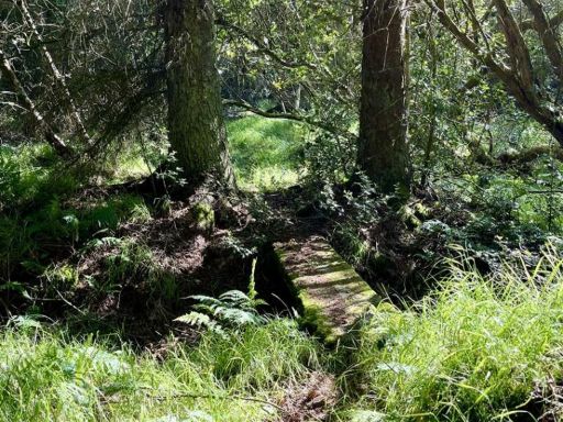 Farm land for sale in Nr The Bog, Minsterley, Shrewsbury, SY5 — £70,000 • 1 bed • 1 bath
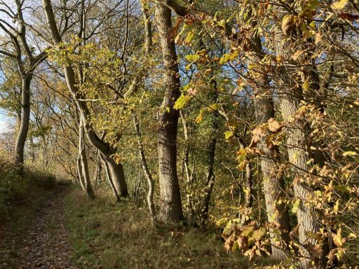 Land for sale in Woodland At Ffinnant Dingle, SY22 — £50,000 • 1 bed • 1 bath
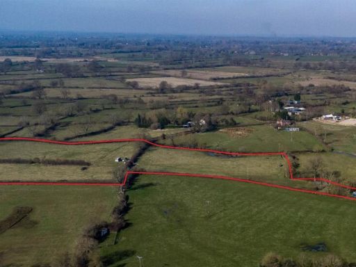 Land for sale in 11.27 acres of Land at Melverley, Oswestry, Shropshire, SY10 8PN, SY10 — £110,000 • 1 bed • 1 bath
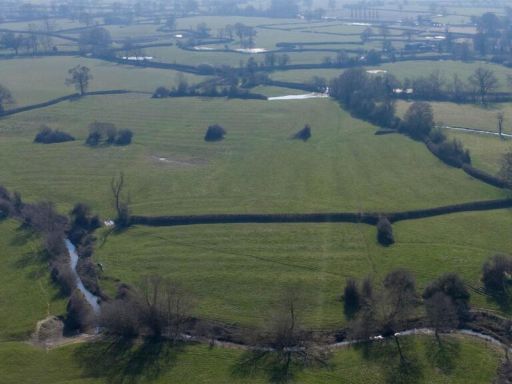 Land for sale in Land at Ponthen, Melverley, SY10 — £200,000 • 1 bed • 1 bath
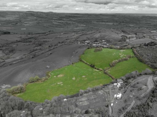 Land for sale in Land at Meadowtown, Shrewsbury, SY5 — £125,000 • 1 bed • 1 bath
Meta
- {
"@context": "https://schema.org",
"@type": "Residence",
"name": "Detached house for sale in Blackmore, Westbury, Shrewsbury,…",
"description": "",
"url": "https://propertypiper.co.uk/property/8f5f24aa-5cfa-4822-b195-649a491d4ac6",
"image": "https://image-a.propertypiper.co.uk/2dd41007-78c3-4466-8db4-24dbc98ef158-1024.jpeg",
"address": {
"@type": "PostalAddress",
"streetAddress": "WOODLANDS, SHREWSBURY, BLACKMORE, WESTBURY",
"postalCode": "SY5 9RN",
"addressLocality": "Shropshire",
"addressRegion": "Shrewsbury and Atcham",
"addressCountry": "England"
},
"geo": {
"@type": "GeoCoordinates",
"latitude": 52.6748891,
"longitude": -3.0211415
},
"numberOfRooms": 1,
"numberOfBathroomsTotal": 1,
"offers": {
"@type": "Offer",
"price": 265000,
"priceCurrency": "GBP",
"availability": "https://schema.org/InStock"
},
"additionalProperty": [
{
"@type": "PropertyValue",
"name": "Feature",
"value": "agricultural land"
},
{
"@type": "PropertyValue",
"name": "Feature",
"value": "rural"
},
{
"@type": "PropertyValue",
"name": "Feature",
"value": "countryside"
},
{
"@type": "PropertyValue",
"name": "Feature",
"value": "meadow"
},
{
"@type": "PropertyValue",
"name": "Feature",
"value": "pasture"
},
{
"@type": "PropertyValue",
"name": "Feature",
"value": "grazing land"
},
{
"@type": "PropertyValue",
"name": "Feature",
"value": "acreage"
},
{
"@type": "PropertyValue",
"name": "Feature",
"value": "investment"
},
{
"@type": "PropertyValue",
"name": "Feature",
"value": "development potential"
},
{
"@type": "PropertyValue",
"name": "Feature",
"value": "privacy"
},
{
"@type": "PropertyValue",
"name": "Feature",
"value": "land"
},
{
"@type": "PropertyValue",
"name": "Feature",
"value": "lots"
},
{
"@type": "PropertyValue",
"name": "Feature",
"value": "development opportunity"
},
{
"@type": "PropertyValue",
"name": "Feature",
"value": "agriculture"
},
{
"@type": "PropertyValue",
"name": "Feature",
"value": "investment"
},
{
"@type": "PropertyValue",
"name": "Feature",
"value": "rural"
},
{
"@type": "PropertyValue",
"name": "Feature",
"value": "plot"
},
{
"@type": "PropertyValue",
"name": "Feature",
"value": "expansion"
}
]
}