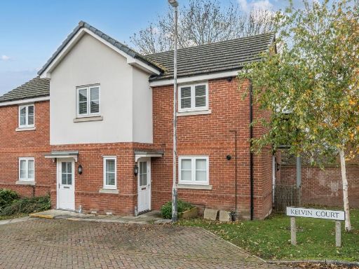
HP13 5RQ - 2 bedroom maisonette for sale in High Wycombe, Buckinghamsh…
View on Property Piper
2 bedroom maisonette for sale in High Wycombe, Buckinghamshire, HP13
Property Details
- Price: £210000
- Bedrooms: 2
- Bathrooms: 1
- Property Type: undefined
- Property SubType: undefined
Image Descriptions
- a semi-detached house modern
- open plan living area modern
Floorplan Description
- First floor flat with kitchen/sitting/dining room and two bedrooms plus bathroom (balcony present).
Rooms
- Kitchen / Sitting / Dining Room:
- Bedroom 2:
- Bedroom 1:
Textual Property Features
- Is Shared Ownership
- Success
Detected Visual Features
- modern house
- semi-detached
- two-story
- well-maintained
- driveway
- kerb appeal
- residential area
- suburban
- brick
- open plan
- modern style
- balcony
- natural light
- hardwood flooring
- integrated kitchen
- up-to-date
EPC Details
- Fully double glazed
- Timber frame, as built, insulated (assumed)
- Boiler and radiators, mains gas
- Low energy lighting in all fixed outlets
- (another dwelling below)
Nearby Schools
- St Michael's Catholic School
- The Highcrest Academy
- The Royal Grammar School, High Wycombe
- Booker Hill School
- Godstowe Preparatory School
- The Downley School
- Chepping View Primary Academy
- Abbey View Primary Academy
- Crown House School
- High Wycombe Church of England Combined School
- The Disraeli School
- Cressex Community School
- John Hampden Grammar School
- Wycombe High School
- Wycombe Abbey
- Castlefield School
- The Chalfonts Independent Grammar School
- Oakridge School
- Hamilton Academy
- Millbrook Combined School
- Highworth Combined School and Nursery
- Pipers Corner School
Nearest General Shops
- Id: 5735211557
- Tags:
- Name: Just Tyres
- Shop: tyres
- Website: https://www.justtyres.co.uk/pages/tyres-high-wycombe
- TagsNormalized:
- Lat: 51.6343144
- Lon: -0.7630509
- FullGeoHash: gcpmwxsretu4
- PartitionGeoHash: gcpm
- Images:
- FoodStandards: null
- Distance: 321.5
,- Id: 5949407821
- Tags:
- Name: Blades
- Shop: hairdresser
- TagsNormalized:
- Lat: 51.6388391
- Lon: -0.7632406
- FullGeoHash: gcpmy8s4p1q9
- PartitionGeoHash: gcpm
- Images:
- FoodStandards: null
- Distance: 271.2
,- Id: 5949407822
- Tags:
- Name: Hair & Beauty Boutique
- Shop: hairdresser
- Website: http://thehbboutique.co.uk/
- TagsNormalized:
- beauty
- boutique
- hairdresser
- shop
- Lat: 51.638837
- Lon: -0.7631912
- FullGeoHash: gcpmy8s602gm
- PartitionGeoHash: gcpm
- Images:
- FoodStandards: null
- Distance: 269
}
Nearest Grocery shops
- Id: 5735210958
- Tags:
- TagsNormalized:
- Lat: 51.6343344
- Lon: -0.7546288
- FullGeoHash: gcpmwzdrzcef
- PartitionGeoHash: gcpm
- Images:
- FoodStandards: null
- Distance: 517.2
,- Id: 5949407824
- Tags:
- Fhrs:
- Name: NN Food & Wine
- Shop: convenience
- TagsNormalized:
- Lat: 51.6388297
- Lon: -0.7630183
- FullGeoHash: gcpmy8s3urs3
- PartitionGeoHash: gcpm
- Images:
- FoodStandards:
- Id: 998843
- FHRSID: 998843
- LocalAuthorityBusinessID: 17/00107/MIXED
- BusinessName: NN Food & Wine
- BusinessType: Retailers - other
- BusinessTypeID: 4613
- AddressLine1: 23 Brindley Avenue
- AddressLine2: High Wycombe
- AddressLine3: Buckinghamshire
- AddressLine4: null
- PostCode: HP13 5SX
- RatingValue: 3
- RatingKey: fhrs_3_en-GB
- RatingDate: 2018-08-14
- LocalAuthorityCode: 021
- LocalAuthorityName: Buckinghamshire
- LocalAuthorityWebSite: http://www.buckinghamshire.gov.uk
- LocalAuthorityEmailAddress: environmentalhealth@buckinghamshire.gov.uk
- Scores:
- Hygiene: 10
- Structural: 10
- ConfidenceInManagement: 10
- NewRatingPending: false
- Geocode:
- Longitude: -0.76291400000000
- Latitude: 51.63878900000000
- Distance: 261.5
,- Id: 2290387298
- Tags:
- Brand: Londis
- Brand:wikidata: Q21008564
- Facebook: https://www.facebook.com/taraslondis/
- Name: Tara's News
- Operator: Londis
- Ref:
- Shop: convenience
- Source: survey
- Survey:
- Website: https://www.londis.co.uk/our-stores/taras
- TagsNormalized:
- Lat: 51.6388212
- Lon: -0.7628211
- FullGeoHash: gcpmy8s9bvzr
- PartitionGeoHash: gcpm
- Images:
- FoodStandards: null
- Distance: 253.3
}
Nearest Religious buildings
- Id: 548784781
- Tags:
- Amenity: place_of_worship
- Building: yes
- Denomination: jehovahs_witness
- Name: Kingdom Hall
- Religion: christian
- TagsNormalized:
- place of worship
- jehovah
- jehovahs witness
- christian
- church
- Lat: 51.6355011
- Lon: -0.7543169
- FullGeoHash: gcpmwzfwx5h9
- PartitionGeoHash: gcpm
- Images:
- FoodStandards: null
- Distance: 479.6
,- Id: 604413765
- Tags:
- Amenity: place_of_worship
- Building: church
- Denomination: seventh_day_adventist
- Name: Wycombe Community Seventh Day Adventist Church
- Religion: christian
- Website: https://www.wcsda.org.uk/
- TagsNormalized:
- place of worship
- church
- adventist
- seventh day adventist
- christian
- Lat: 51.6335223
- Lon: -0.764421
- FullGeoHash: gcpmwxe75dnm
- PartitionGeoHash: gcpm
- Images:
- FoodStandards: null
- Distance: 445.3
,- Id: 628671958
- Tags:
- Amenity: place_of_worship
- Denomination: baptist
- Name: Grace Baptist Church
- Religion: christian
- Website: http://gracebaptisthw.org.uk/
- TagsNormalized:
- place of worship
- baptist
- church
- christian
- Lat: 51.6380179
- Lon: -0.7638873
- FullGeoHash: gcpmy87v20hr
- PartitionGeoHash: gcpm
- Images:
- FoodStandards: null
- Distance: 241.8
}
Nearest Medical buildings
- Id: 3799000450
- Tags:
- Amenity: pharmacy
- Fhrs:
- Healthcare: pharmacy
- Name: Victoria Pharmacy
- Opening_hours: Mo-Fr 09:00-19:00; Sa 09:00-13:00
- Website: https://www.manichem.co.uk/branches/victoria-pharmacy/
- TagsNormalized:
- Lat: 51.6327612
- Lon: -0.7616801
- FullGeoHash: gcpmwxmqes61
- PartitionGeoHash: gcpm
- Images:
- FoodStandards:
- Id: 564469
- FHRSID: 564469
- LocalAuthorityBusinessID: 13/00420/FOOD
- BusinessName: Victoria Pharmacy
- BusinessType: Retailers - other
- BusinessTypeID: 4613
- AddressLine1: 19 Desborough Avenue
- AddressLine2: High Wycombe
- AddressLine3: Bucks
- AddressLine4: null
- PostCode: HP11 2RS
- RatingValue: Exempt
- RatingKey: fhrs_exempt_en-GB
- RatingDate: 2008-09-02
- LocalAuthorityCode: 021
- LocalAuthorityName: Buckinghamshire
- LocalAuthorityWebSite: http://www.buckinghamshire.gov.uk
- LocalAuthorityEmailAddress: environmentalhealth@buckinghamshire.gov.uk
- Scores:
- Hygiene: null
- Structural: null
- ConfidenceInManagement: null
- NewRatingPending: false
- Geocode:
- Longitude: -0.76158700000000
- Latitude: 51.63286800000000
- Distance: 461
,- Id: 3799000451
- Tags:
- Amenity: clinic
- Name: Wye Valley Surgery
- Website: https://www.wyevalleysurgery.co.uk/
- TagsNormalized:
- Lat: 51.633043
- Lon: -0.7619305
- FullGeoHash: gcpmwxt0m8z6
- PartitionGeoHash: gcpm
- Images:
- FoodStandards: null
- Distance: 432.4
,- Id: 5735211225
- Tags:
- Amenity: pharmacy
- Healthcare: pharmacy
- Name: Lansdales
- Website: https://www.lansdalespharmacy.com/
- TagsNormalized:
- Lat: 51.633015
- Lon: -0.7615368
- FullGeoHash: gcpmwxt2ngt5
- PartitionGeoHash: gcpm
- Images:
- FoodStandards: null
- Distance: 431.9
,- Id: 295916108
- Tags:
- Amenity: doctors
- Name: Riverside Surgery
- Website: https://www.theriversidesurgeryhighwycombe.nhs.uk/
- TagsNormalized:
- Lat: 51.6330715
- Lon: -0.7604625
- FullGeoHash: gcpmwxw0rynh
- PartitionGeoHash: gcpm
- Images:
- FoodStandards: null
- Distance: 424.5
}
Nearest Airports
- Id: 14001268
- Tags:
- Access: yes
- Aerodrome: international
- Aerodrome:type: public
- Aeroway: aerodrome
- Alt_name: London Heathrow
- Alt_name_2: London Heathrow Airport
- Ele: 25
- Iata: LHR
- Icao: EGLL
- Int_name: Heathrow Airport
- Name: London Heathrow Airport
- Note: area still approx
- Old_name: London Airport
- Operator: Heathrow Airport Limited
- Rank_aci:
- Ref: LHR
- Short_name: Heathrow
- Type: multipolygon
- Website: https://www.heathrow.com/
- Wikidata: Q8691
- Wikipedia: en:Heathrow Airport
- TagsNormalized:
- airport
- international airport
- Lat: 51.4677522
- Lon: -0.4547736
- FullGeoHash: gcpsv9kv7h2h
- PartitionGeoHash: gcps
- Images:
- FoodStandards: null
- Distance: 28313.7
}
Nearest Leisure Facilities
- Id: 629989762
- Tags:
- Description: Small tarmaced square, one hoop
- Leisure: pitch
- Sport: basketball
- TagsNormalized:
- pitch
- leisure
- basketball
- sports
- Lat: 51.6404556
- Lon: -0.7609624
- FullGeoHash: gcpmy8vgkq9k
- PartitionGeoHash: gcpm
- Images:
- FoodStandards: null
- Distance: 397.7
,- Id: 629989763
- Tags:
- TagsNormalized:
- Lat: 51.640373
- Lon: -0.7609579
- FullGeoHash: gcpmy8vfurhx
- PartitionGeoHash: gcpm
- Images:
- FoodStandards: null
- Distance: 388.5
,- Id: 584212188
- Tags:
- Barrier: fence
- Leisure: playground
- TagsNormalized:
- Lat: 51.6403243
- Lon: -0.7606203
- FullGeoHash: gcpmy8y4sq0m
- PartitionGeoHash: gcpm
- Images:
- FoodStandards: null
- Distance: 383.6
,- Id: 5735211534
- Tags:
- Leisure: fitness_centre
- Name: Marvel Fitness
- TagsNormalized:
- fitness
- fitness centre
- leisure
- Lat: 51.6348813
- Lon: -0.7649124
- FullGeoHash: gcpmwxg4bpxb
- PartitionGeoHash: gcpm
- Images:
- FoodStandards: null
- Distance: 354.9
,- Id: 584212192
- Tags:
- TagsNormalized:
- Lat: 51.635784
- Lon: -0.757721
- FullGeoHash: gcpmyb00pzf3
- PartitionGeoHash: gcpm
- Images:
- FoodStandards: null
- Distance: 251
}
Nearest Tourist attractions
- Id: 5922943752
- Tags:
- Name: Chair Making Museum
- Operator: Kraftinwood
- Tourism: museum
- Website: http://www.kraftinwood.com/high-wycombe-chair-making-museum/
- Wikidata: Q6659038
- Wikipedia: en:Living Chair Museum
- TagsNormalized:
- Lat: 51.6349679
- Lon: -0.7731709
- FullGeoHash: gcpmwrugrz9v
- PartitionGeoHash: gcpm
- Images:
- FoodStandards: null
- Distance: 873
,- Id: 5935211425
- Tags:
- Tourism: gallery
- Website: http://www.kraftinwood.com/1218-2/
- TagsNormalized:
- Lat: 51.6349104
- Lon: -0.7730582
- FullGeoHash: gcpmwrv54kyn
- PartitionGeoHash: gcpm
- Images:
- FoodStandards: null
- Distance: 867.1
,- Id: 1543303182
- Tags:
- Addr:
- City: High Wycombe
- Postcode: HP13 5GG
- Street: Hughenden Avenue
- Designation: Student Hall of Residence
- Guest_house: hostel
- Internet_access: wlan
- Name: Hughenden Park Student Village
- Source: Local knowledge
- Tourism: hostel
- TagsNormalized:
- Lat: 51.6389043
- Lon: -0.7532191
- FullGeoHash: gcpmybed2trn
- PartitionGeoHash: gcpm
- Images:
- FoodStandards: null
- Distance: 576
}
Nearest Bus stations and stops
- Id: 3687499841
- Tags:
- Bus: yes
- Departures_board: timetable
- Highway: bus_stop
- Name: Cedar Terrace
- Public_transport: platform
- Shelter: no
- TagsNormalized:
- Lat: 51.6321266
- Lon: -0.7633712
- FullGeoHash: gcpmwxk4unj0
- PartitionGeoHash: gcpm
- Images:
- FoodStandards: null
- Distance: 555.3
,- Id: 3801845159
- Tags:
- Bus: yes
- Highway: bus_stop
- Public_transport: platform
- Route_ref: 312
- TagsNormalized:
- Lat: 51.6329192
- Lon: -0.7619013
- FullGeoHash: gcpmwxmpw3v0
- PartitionGeoHash: gcpm
- Images:
- FoodStandards: null
- Distance: 445.7
,- Id: 3801845160
- Tags:
- Bus: yes
- Highway: bus_stop
- Public_transport: platform
- Route_ref: 312
- TagsNormalized:
- Lat: 51.6331606
- Lon: -0.7616468
- FullGeoHash: gcpmwxt2uqfb
- PartitionGeoHash: gcpm
- Images:
- FoodStandards: null
- Distance: 416.7
,- Id: 10284902479
- Tags:
- Bus: yes
- Highway: bus_stop
- Public_transport: platform
- TagsNormalized:
- Lat: 51.638684
- Lon: -0.7601851
- FullGeoHash: gcpmy8w3nkku
- PartitionGeoHash: gcpm
- Images:
- FoodStandards: null
- Distance: 206.7
,- Id: 10284902478
- Tags:
- Bus: yes
- Highway: bus_stop
- Public_transport: platform
- TagsNormalized:
- Lat: 51.6382331
- Lon: -0.7600244
- FullGeoHash: gcpmy8qwd0kd
- PartitionGeoHash: gcpm
- Images:
- FoodStandards: null
- Distance: 162.3
}
Nearest Hotels
- Id: 5735211765
- Tags:
- Name: Jupiter Hotels
- Tourism: hotel
- TagsNormalized:
- Lat: 51.6299558
- Lon: -0.7577294
- FullGeoHash: gcpmwybnr9k4
- PartitionGeoHash: gcpm
- Images:
- FoodStandards: null
- Distance: 800.4
,- Id: 548600876
- Tags:
- Addr:
- City: High Wycombe
- Postcode: HP13 5FX
- Street: Premier Way
- Brand: Premier Inn
- Brand:wikidata: Q2108626
- Building: yes
- Fhrs:
- Internet_access: wlan
- Internet_access:fee: customers
- Internet_access:operator: Virgin Media
- Internet_access:ssid: Premier Inn Free Wi-Fi
- Name: Premier Inn
- Source:
- Tourism: hotel
- Website: https://www.premierinn.com/gb/en/hotels/england/buckinghamshire/high-wycombe/high-wycombe-central.html
- TagsNormalized:
- Lat: 51.6322956
- Lon: -0.7536477
- FullGeoHash: gcpmwz75ytx8
- PartitionGeoHash: gcpm
- Images:
- FoodStandards: null
- Distance: 714.4
,- Id: 5735211457
- Tags:
- Fhrs:
- Name: Buckingham Hotel
- Tourism: hotel
- Website: http://www.buckinghamhoteluk.com/
- TagsNormalized:
- Lat: 51.6367308
- Lon: -0.769845
- FullGeoHash: gcpmy2pmv23c
- PartitionGeoHash: gcpm
- Images:
- FoodStandards: null
- Distance: 617.4
}
Tags
- modern house
- semi-detached
- two-story
- well-maintained
- driveway
- kerb appeal
- residential area
- suburban
- brick
- open plan
- modern style
- balcony
- natural light
- hardwood flooring
- integrated kitchen
- up-to-date
Local Market Stats
- Average Price/sqft: £401
- Avg Income: £57300
- Rental Yield: 4%
- Social Housing: 12%
- Planning Success Rate: 83%
AirBnB Data
- 1km average: £101/night
- Listings in 1km: 13
Similar Properties
 2 bedroom maisonette for sale in High Wycombe, Buckinghamshire, HP13 — £280,000 • 2 bed • 1 bath • 878 ft²
 2 bedroom apartment for sale in St Hughs Avenue, High Wycombe, HP13 — £77,000 • 2 bed • 1 bath • 609 ft²
 2 bedroom apartment for sale in Wellesbourne Road, High Wycombe, Buckinghamshire, HP13 — £169,000 • 2 bed • 1 bath • 685 ft²
 2 bedroom apartment for sale in Wycombe House, Wellesbourne Road, High Wycombe, HP13 — £260,000 • 2 bed • 1 bath • 639 ft²
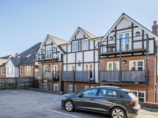 1 bedroom maisonette for sale in High Wycombe, Buckinghamshire, HP12 — £200,000 • 1 bed • 1 bath • 562 ft²
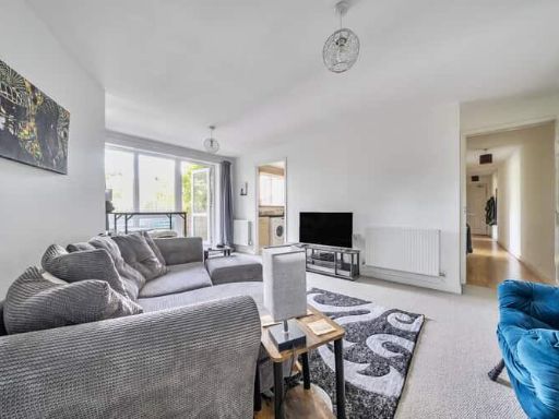 2 bedroom flat for sale in St Hughs Avenue, High Wycombe, Buckinghamshire, HP13 — £132,000 • 2 bed • 1 bath • 699 ft²
Meta
- {
"@context": "https://schema.org",
"@type": "Residence",
"name": "2 bedroom maisonette for sale in High Wycombe, Buckinghamsh…",
"description": "",
"url": "https://propertypiper.co.uk/property/895cf2e5-aca7-419e-ba85-f368245c15ab",
"image": "https://image-a.propertypiper.co.uk/4d0a40cc-9857-48ad-af77-f2875113db88-1024.jpeg",
"address": {
"@type": "PostalAddress",
"streetAddress": "15 Kelvin Court",
"postalCode": "HP13 5RQ",
"addressLocality": "Buckinghamshire",
"addressRegion": "Wycombe",
"addressCountry": "England"
},
"geo": {
"@type": "GeoCoordinates",
"latitude": 51.6368792088107,
"longitude": -0.7609015912105669
},
"numberOfRooms": 2,
"numberOfBathroomsTotal": 1,
"floorSize": {
"@type": "QuantitativeValue",
"value": 807,
"unitCode": "FTK"
},
"offers": {
"@type": "Offer",
"price": 210000,
"priceCurrency": "GBP",
"availability": "https://schema.org/InStock"
},
"additionalProperty": [
{
"@type": "PropertyValue",
"name": "Feature",
"value": "modern house"
},
{
"@type": "PropertyValue",
"name": "Feature",
"value": "semi-detached"
},
{
"@type": "PropertyValue",
"name": "Feature",
"value": "two-story"
},
{
"@type": "PropertyValue",
"name": "Feature",
"value": "well-maintained"
},
{
"@type": "PropertyValue",
"name": "Feature",
"value": "driveway"
},
{
"@type": "PropertyValue",
"name": "Feature",
"value": "kerb appeal"
},
{
"@type": "PropertyValue",
"name": "Feature",
"value": "residential area"
},
{
"@type": "PropertyValue",
"name": "Feature",
"value": "suburban"
},
{
"@type": "PropertyValue",
"name": "Feature",
"value": "brick"
},
{
"@type": "PropertyValue",
"name": "Feature",
"value": "open plan"
},
{
"@type": "PropertyValue",
"name": "Feature",
"value": "modern style"
},
{
"@type": "PropertyValue",
"name": "Feature",
"value": "balcony"
},
{
"@type": "PropertyValue",
"name": "Feature",
"value": "natural light"
},
{
"@type": "PropertyValue",
"name": "Feature",
"value": "hardwood flooring"
},
{
"@type": "PropertyValue",
"name": "Feature",
"value": "integrated kitchen"
},
{
"@type": "PropertyValue",
"name": "Feature",
"value": "up-to-date"
}
]
}
High Res Floorplan Images
Compatible Floorplan Images
FloorplanImages Thumbnail