ME10 1FS - 4 bedroom detached house for sale in PLATINUM WAY, Borden,…
View on Property Piper
4 bedroom detached house for sale in PLATINUM WAY,
Borden,
Sittingbourne,
ME10
Property Details
- Price: £454995
- Bedrooms: 4
- Bathrooms: 1
- Property Type: undefined
- Property SubType: undefined
Brochure Descriptions
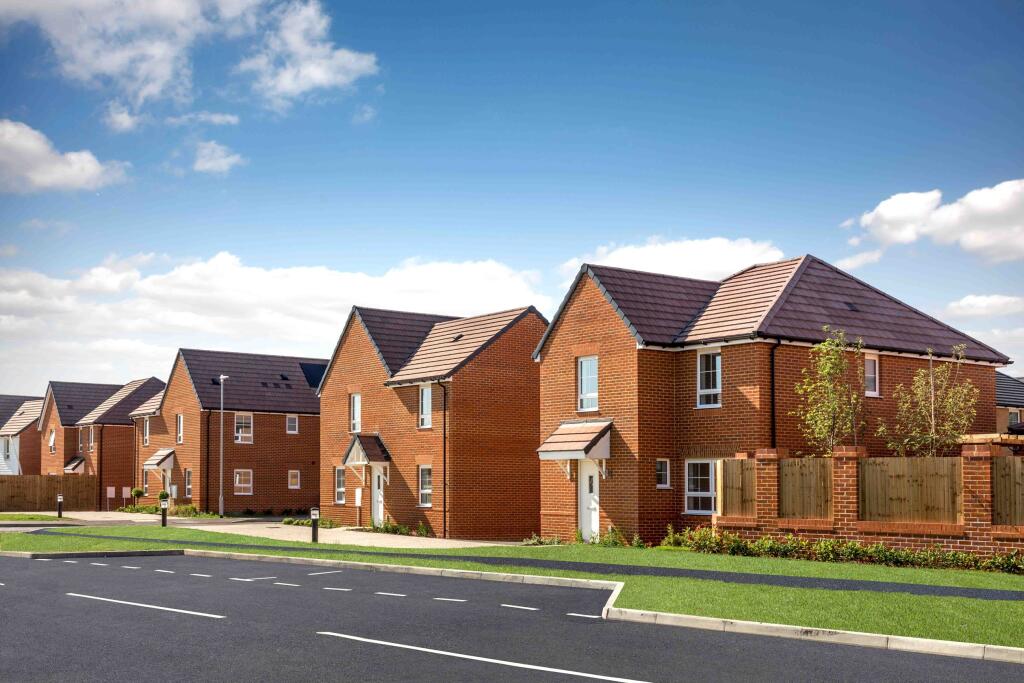
- Document cover for a residential development titled "Cherry Meadows at Applegate Park" by Barratt Homes. The image is a branded brochure/cover and does not show the physical building or street-level detail. Based on the branding alone it appears to be a new-build housing development (likely a planned estate rather than a single dwelling). No information on specific room counts, internal layout, garden size, or views is visible; those details cannot be inferred from this cover image.
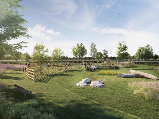
Valuator-style commentary: This is presentation material for a developer-led scheme which suggests a product aimed at the mainstream new-build market. Key value drivers likely include developer reputation (Barratt Homes is an established national builder), scheme positioning (a named development normally targeted at families or first-time buyers), and the implied location tie-in to "Applegate Park" which may indicate proximity to green space. Without street address, photographs, floorplans, or site context it is not possible to provide an accurate size, condition, or market value. Recommended next steps for valuation: obtain the exact property address, floorplans, specification sheet, site plan, and local comparable sales to produce a reliable market value opinion.
- No residential property images or address are visible in the provided image — it appears to be a branded rear brochure page showing Barratt Homes contact details only. As a valuator: there is insufficient information to assess the property. Required information would include exterior frontage, number of floors/rooms, internal photos (kitchen, living areas, bathrooms, bedrooms), plot/garden size and any notable views or nearby amenities. Without those details I cannot infer size, condition or likely value.
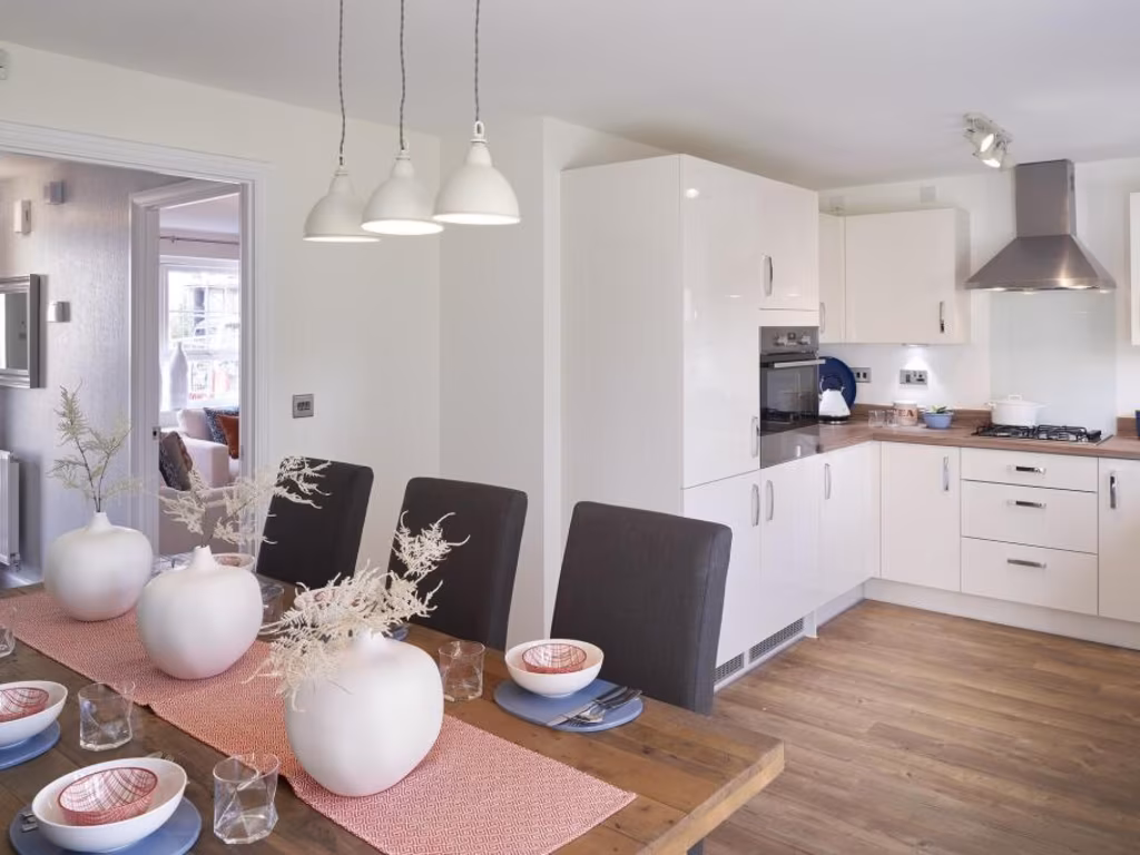
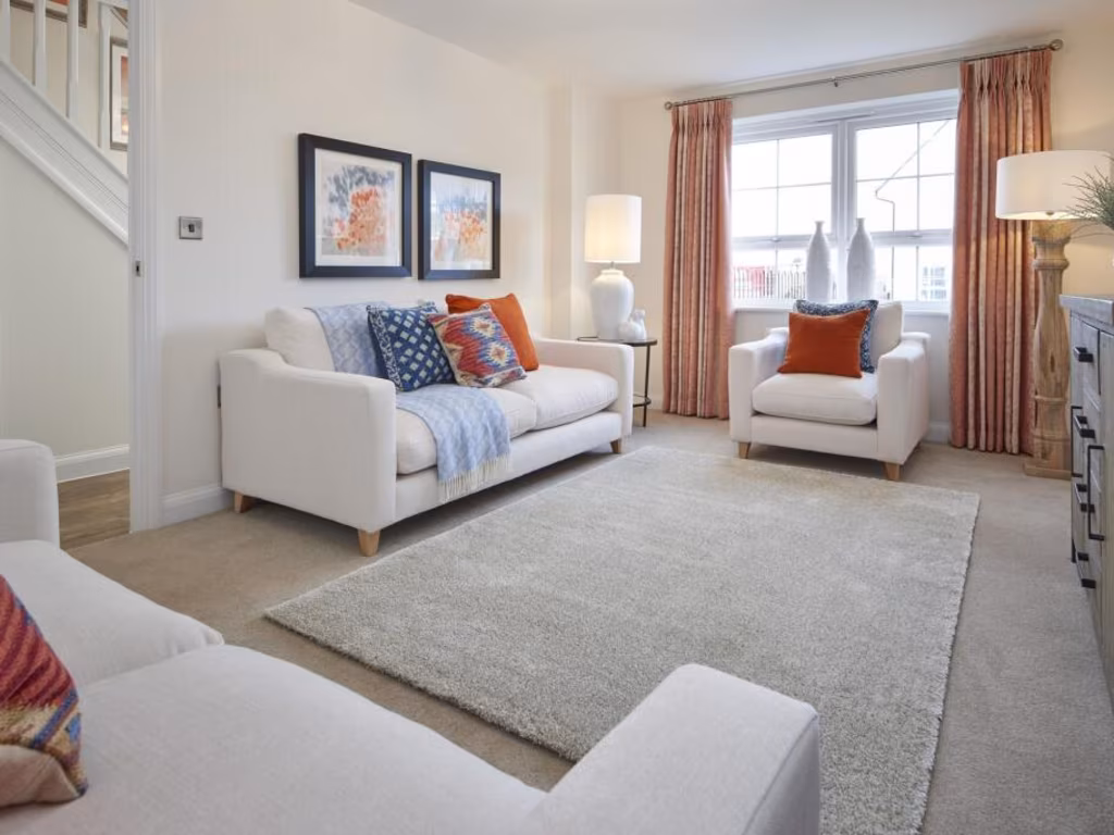
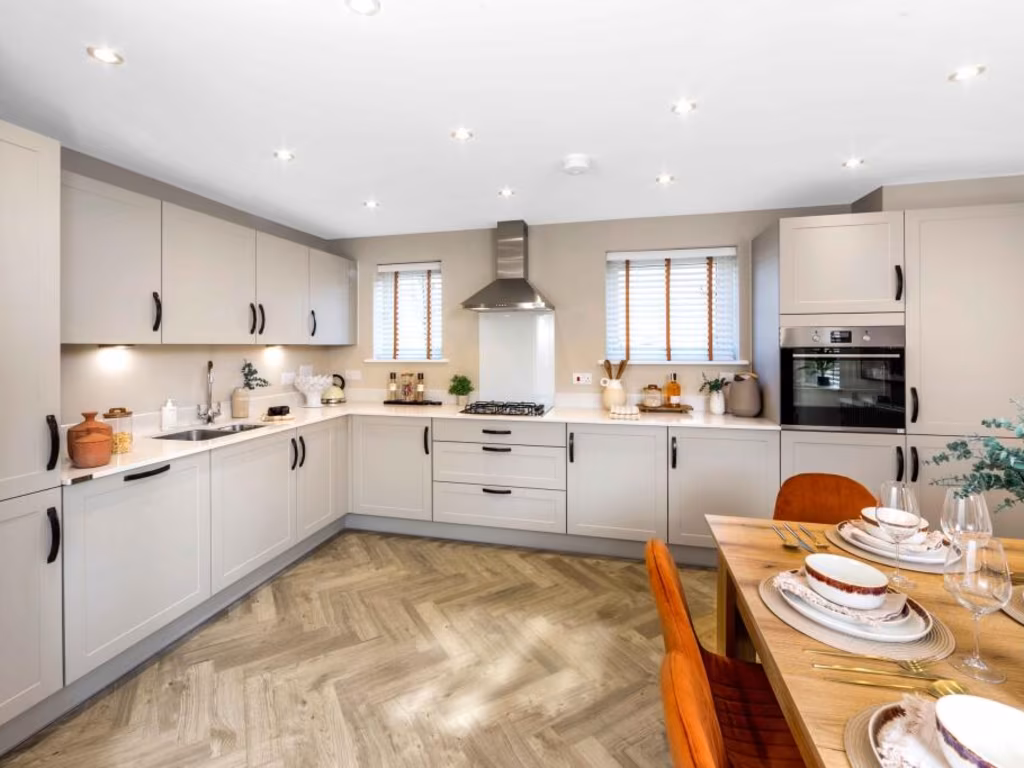
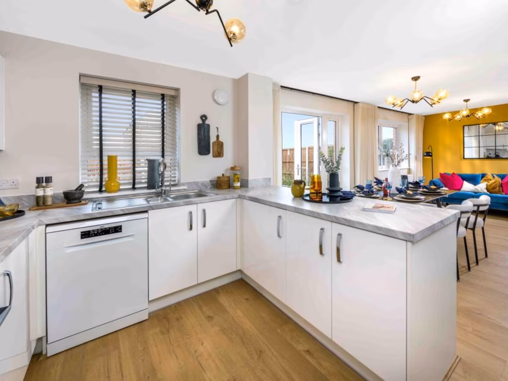
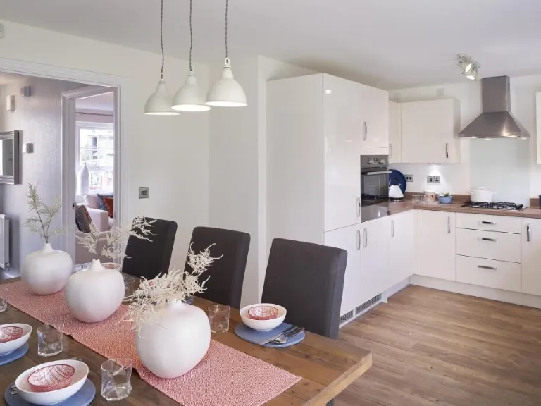
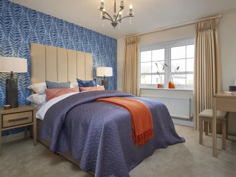
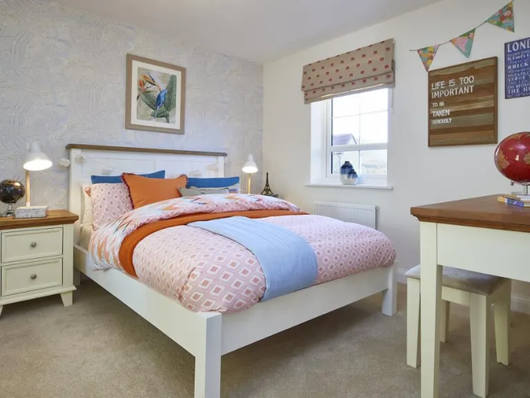
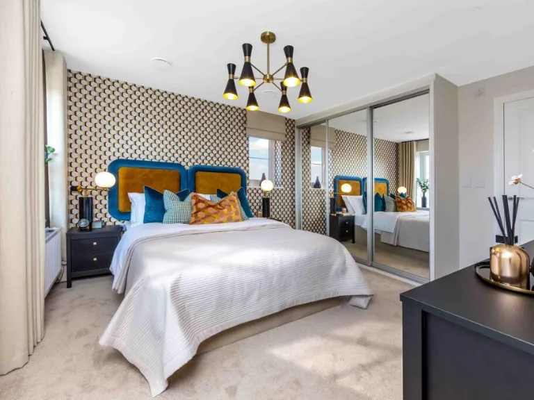
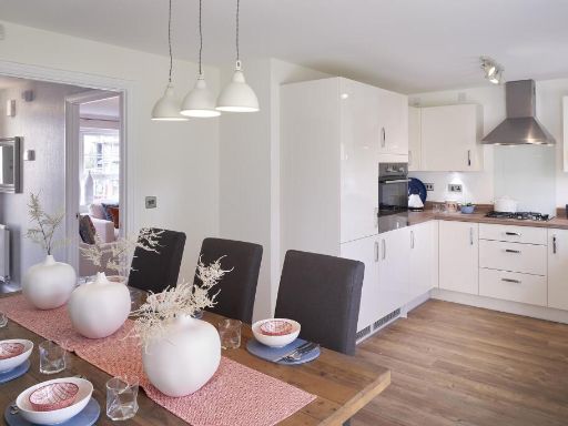
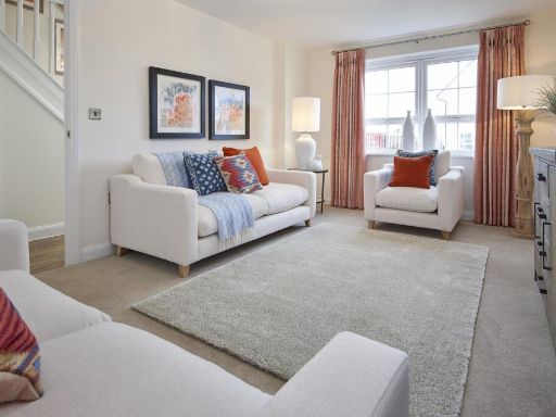
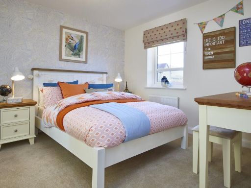
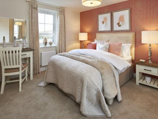
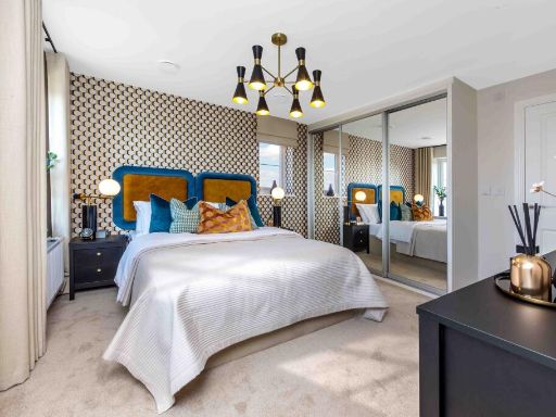
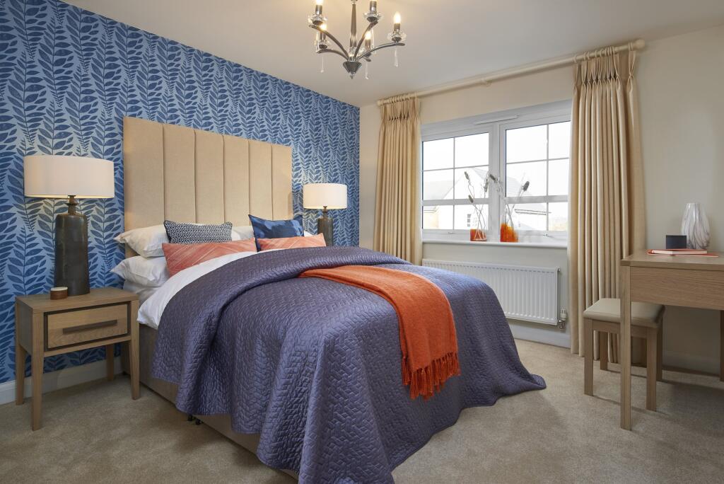
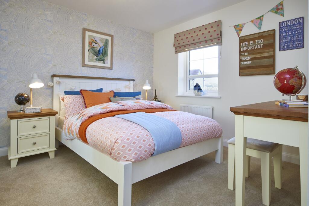
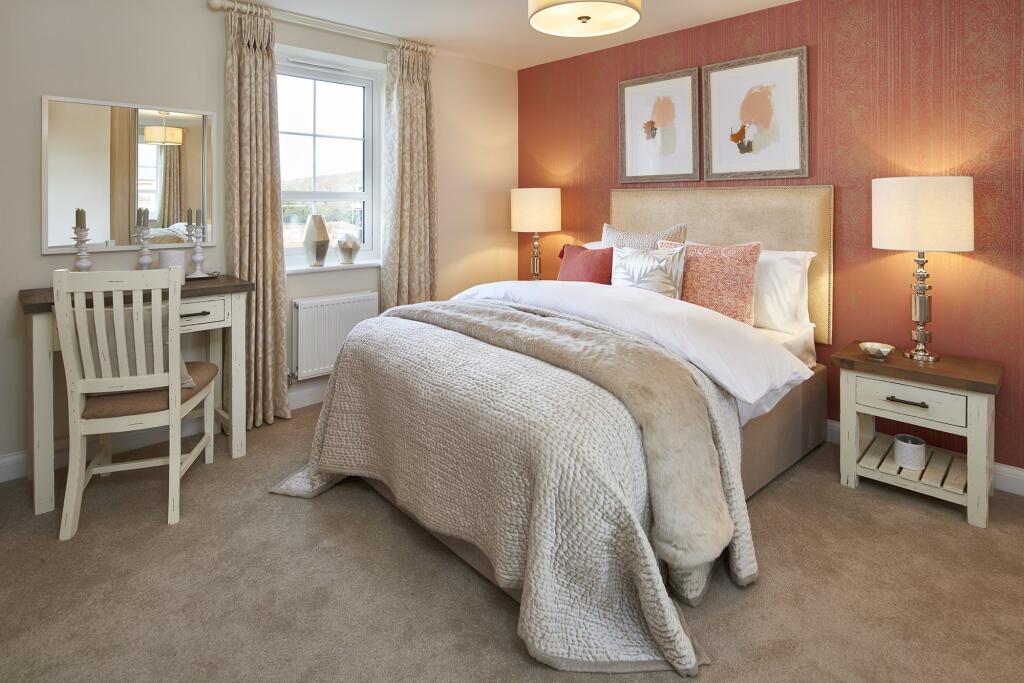
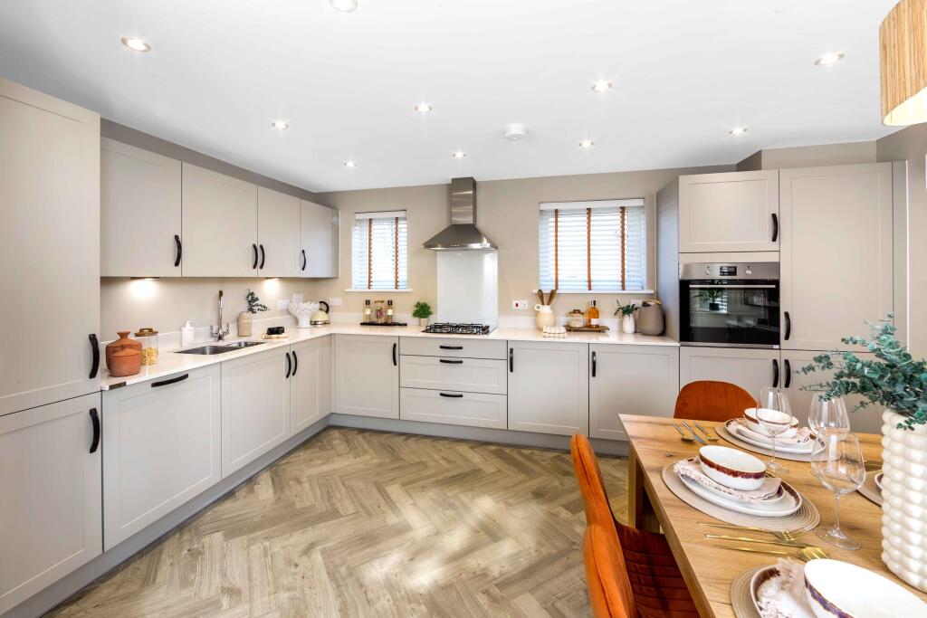
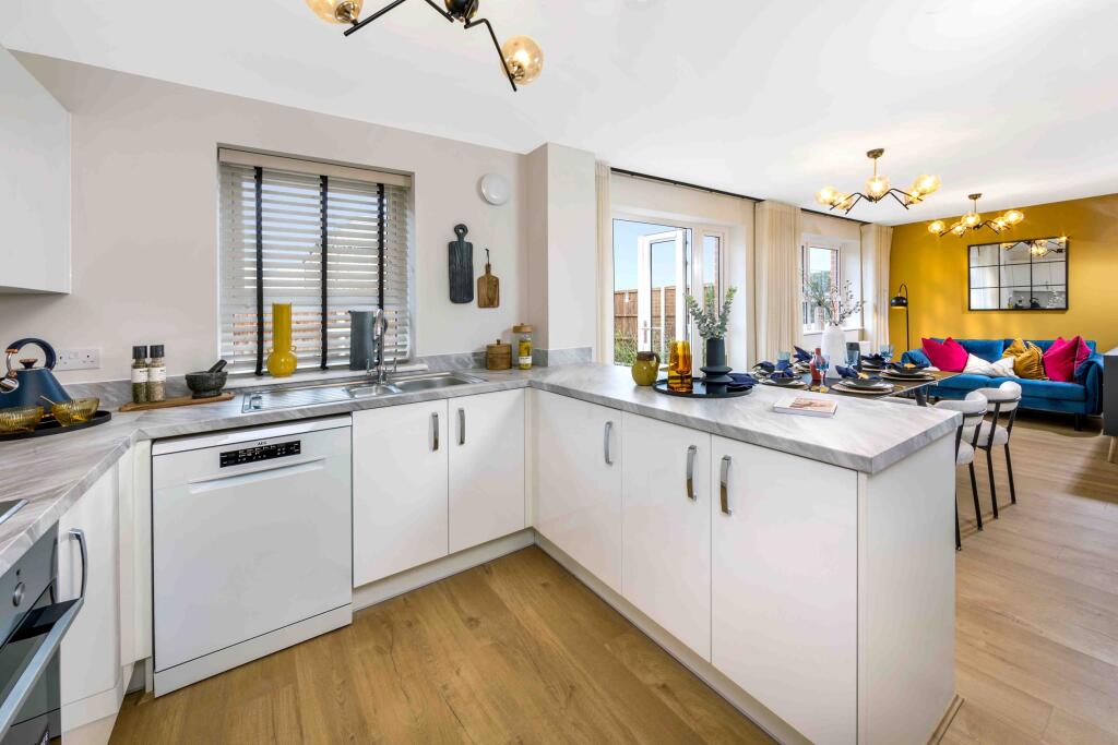
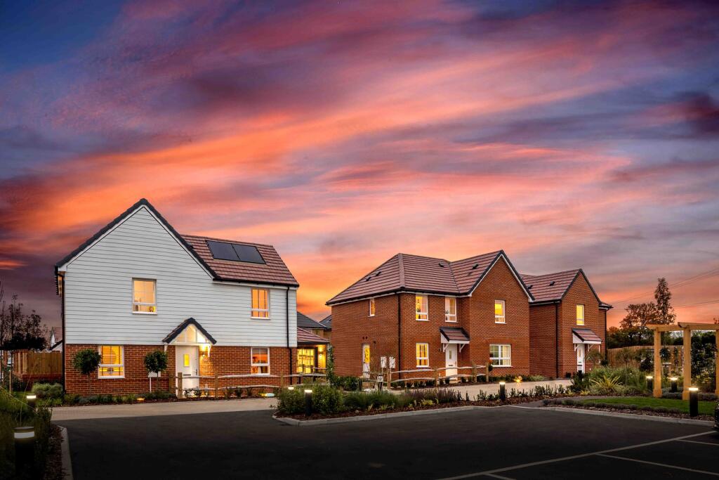
- Modern semi-detached / mid-terrace style new-build show home. Interior images show an open-plan layout with a formal living room featuring a gas or electric inset fireplace and large glazed patio doors opening to a private rear garden (visible fenced lawn area), and an adjoining contemporary kitchen with a central breakfast island and high-gloss units. Rooms receive good natural light from multiple windows and the patio doors; finishes are high-spec with tiled kitchen flooring, recessed ceiling downlights, decorative wallpaper and carpeted living area. Garden appears small-to-average in size suitable for low-maintenance landscaping. Overall the property presents as a medium-sized family home (likely 2–4 bed depending on plan) finished to a developer specification, well suited to young families or downsizers seeking modern open-plan living with a private rear garden and quality fixtures.
Image Descriptions
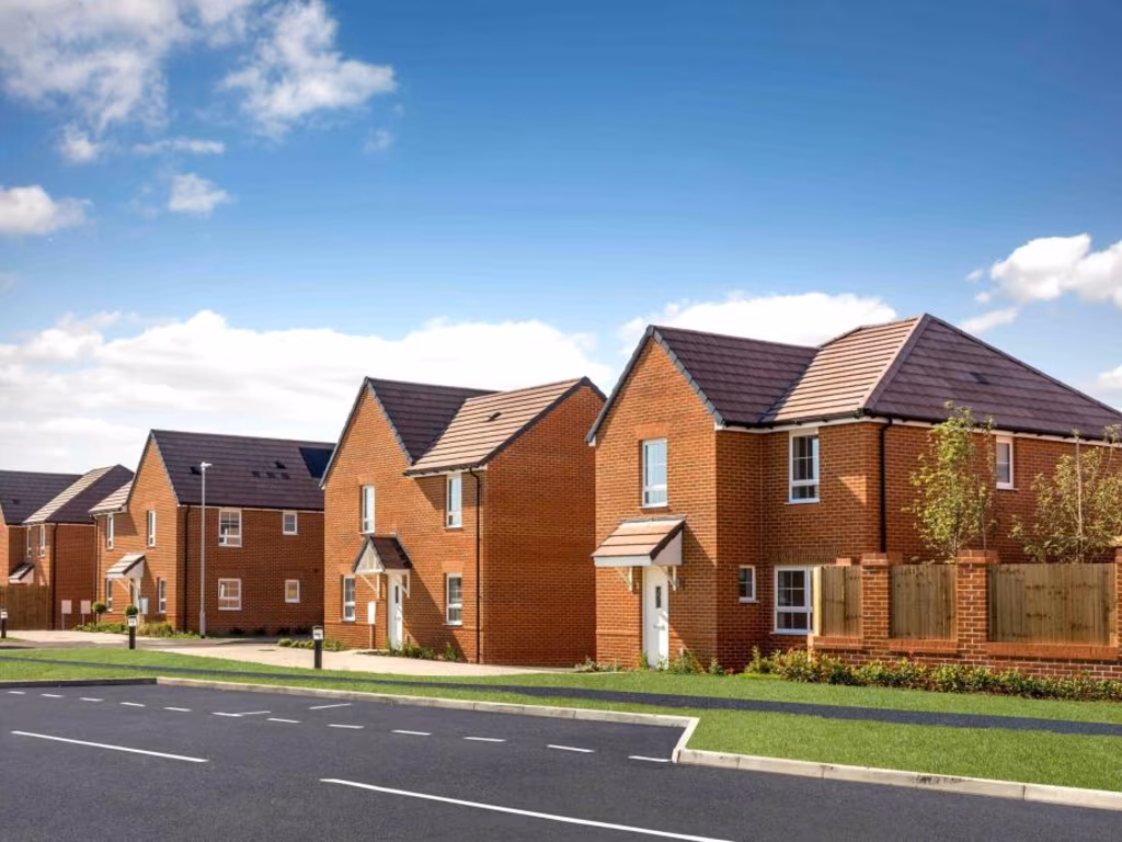
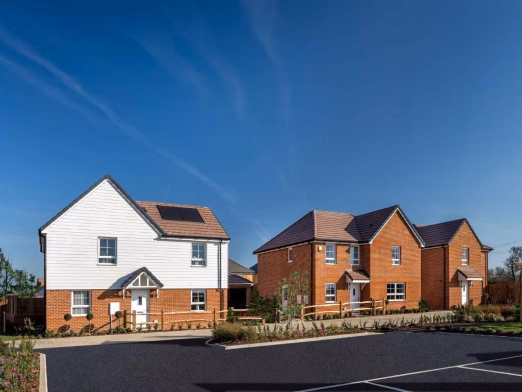
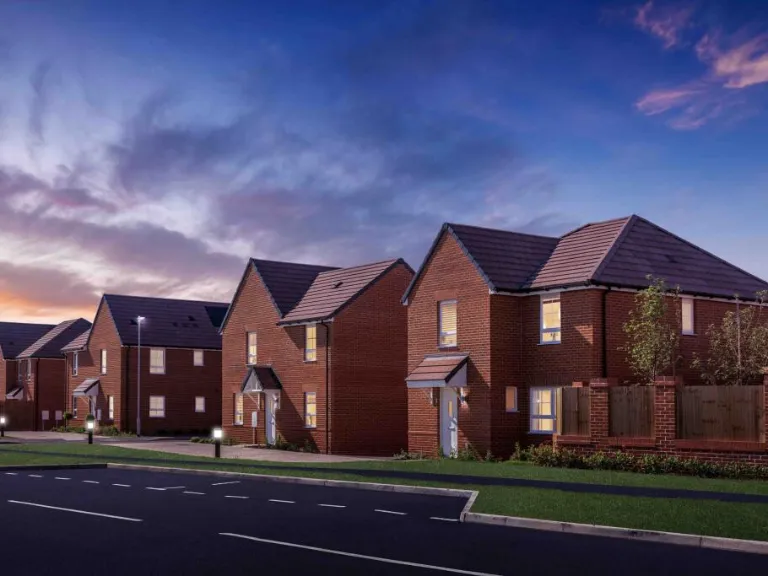
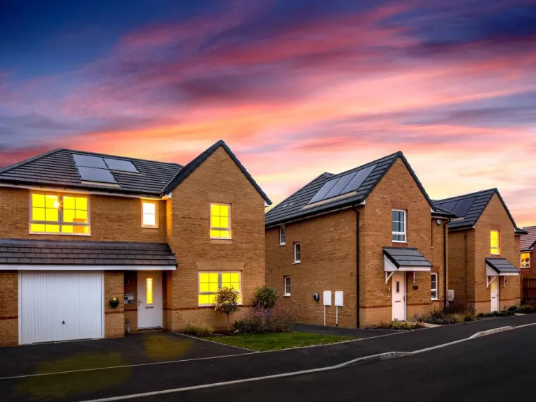
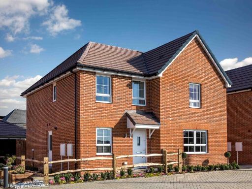
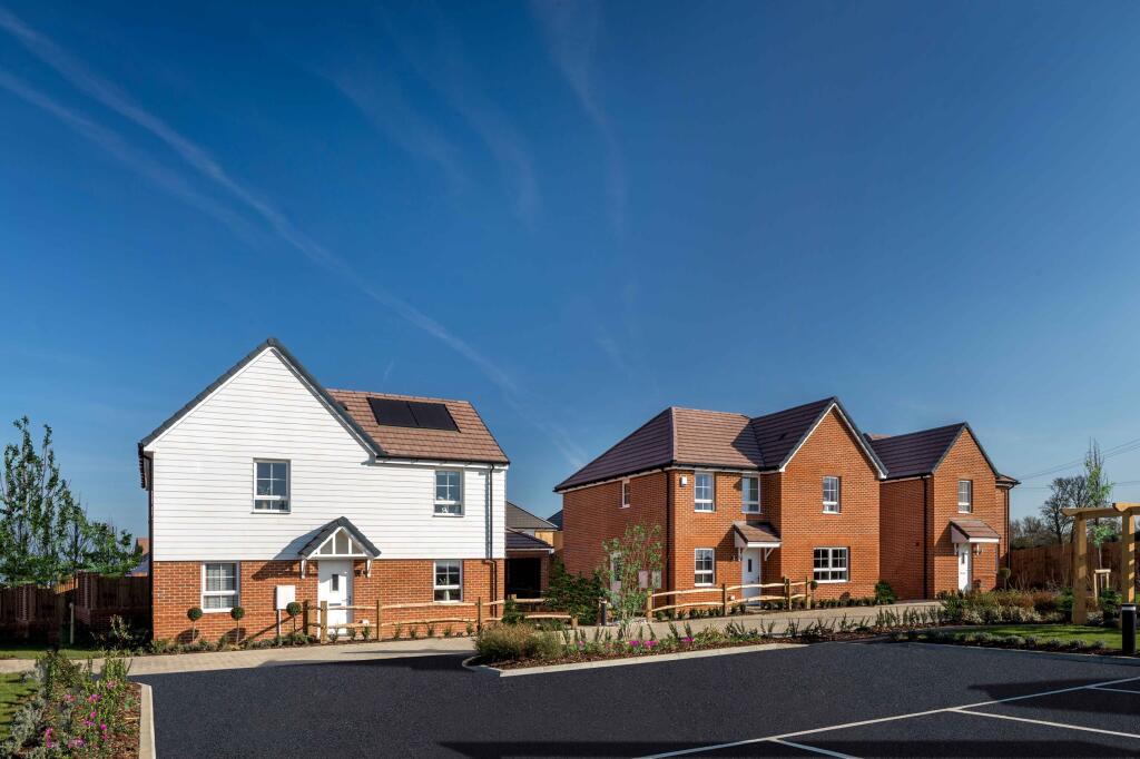
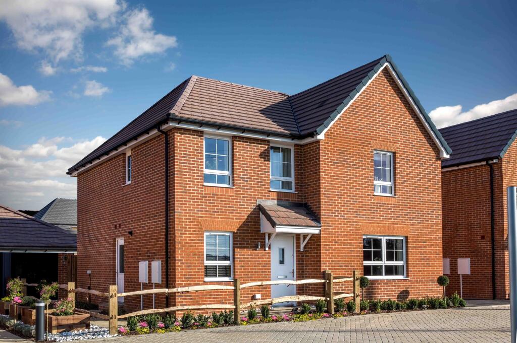
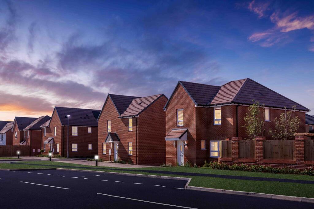
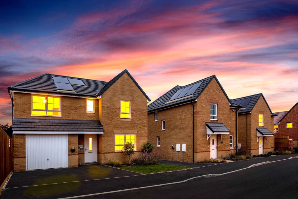
- house exterior modern suburban
- contemporary kitchen-dining area modern
Floorplan Description
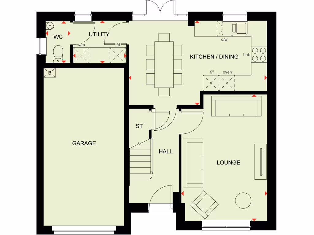
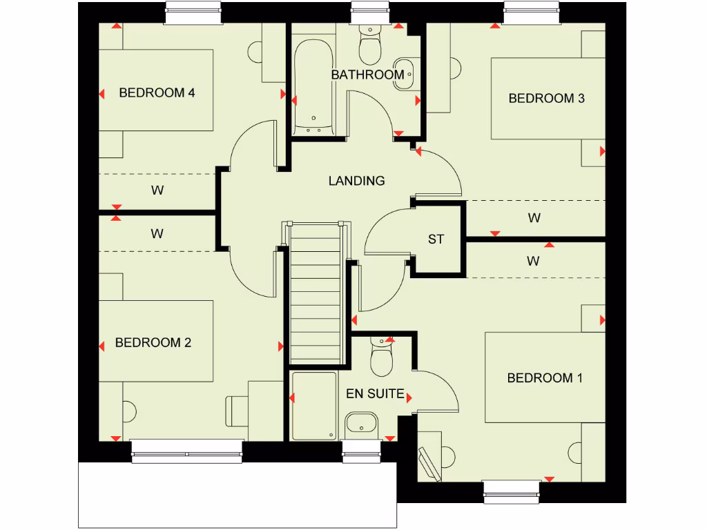
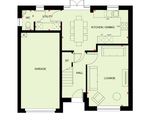
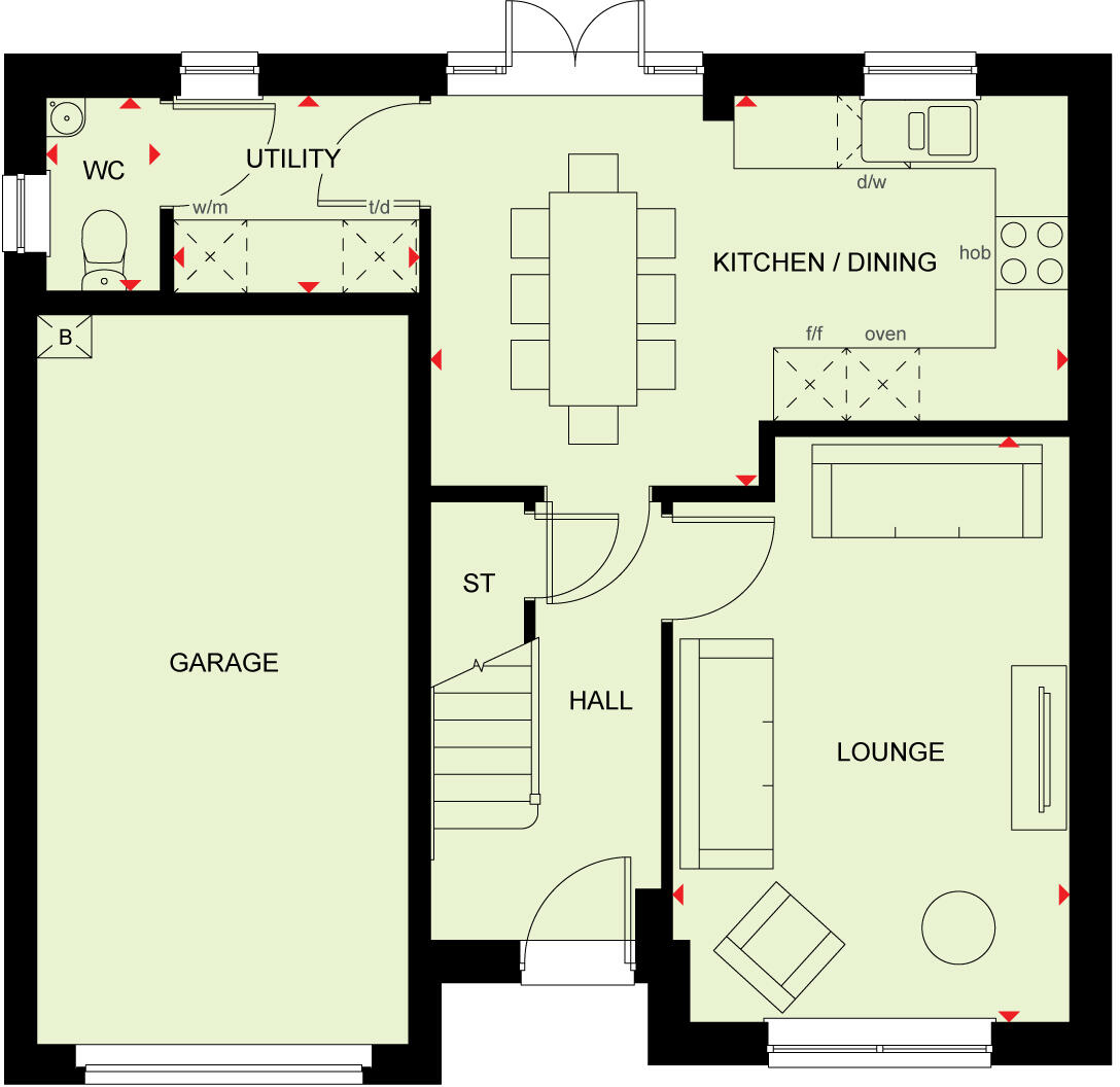
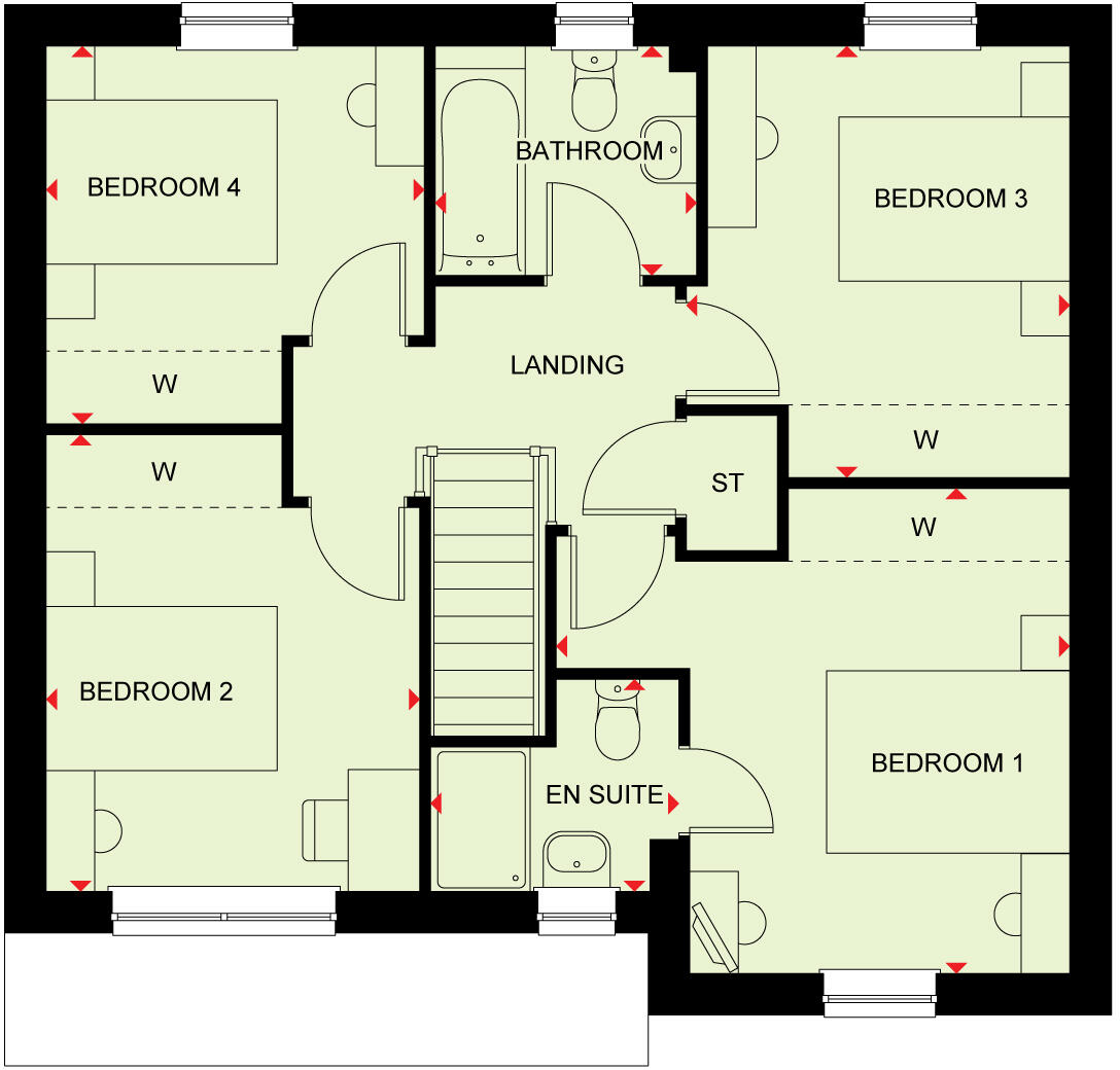
- Ground-floor plan showing kitchen/dining, lounge, utility, WC, hall, store (ST) and garage.
Rooms
- WC:
- UTILITY:
- KITCHEN / DINING:
- GARAGE:
- ST:
- HALL:
- LOUNGE:
- BEDROOM 4:
- BATHROOM:
- LANDING:
- BEDROOM 3:
- BEDROOM 2:
- EN SUITE:
- BEDROOM 1:
- ST:
- W:
Textual Property Features
Detected Visual Features
- modern
- suburban
- detached
- brick
- two-story
- garage
- driveway
- family home
- new build
- low maintenance
- modern kitchen
- white cabinetry
- open plan
- dining area
- pendant lighting
- integrated appliances
- wooden floor
- contemporary design
Nearby Schools
- Minterne Junior School
- South Avenue Primary School
- Westlands School
- Grove Park Primary School
- Rodmersham School
- St Peter's Catholic Primary School
- Borden Church of England Primary School
- VTC Independent School
- Bobbing Village School
- Kemsley Primary Academy
- The Oaks Infant School
- The Sittingbourne School
- Highsted Grammar School
- Milton Court Primary Academy
- Milstead and Frinsted Church of England Primary School
- Bredgar Church of England Primary School
- Tunstall Church of England (Aided) Primary School
- Fulston Manor School
- Canterbury Road Primary School
- Borden Grammar School
- Westlands Primary School
- Sunny Bank Primary School
- Regis Manor Primary School
- Newington Church of England Primary School
- Lower Halstow Primary School
- Iwade School
Nearest General Shops
- Id: 3679922947
- Tags:
- Changing_table: no
- Name: Welcome Sittonbourne
- Opening_hours: Mo-Su 06:00-22:00
- Organic: no
- Shop: supermarket
- Toilets: no
- Toilets:access: private
- Toilets:wheelchair: no
- Wheelchair: limited
- TagsNormalized:
- Lat: 51.3470894
- Lon: 0.7126531
- FullGeoHash: u10s05qyqp0x
- PartitionGeoHash: u10s
- Images:
- FoodStandards: null
- Distance: 919.3
,- Id: 184820195
- Tags:
- Brand: Wickes
- Brand:wikidata: Q7998350
- Brand:wikipedia: en:Wickes
- Building: retail
- Contact:
- Website: https://www.wickes.co.uk/store/8320
- Name: Wickes
- Shop: doityourself
- TagsNormalized:
- wickes
- retail
- doityourself
- shop
- Lat: 51.3426155
- Lon: 0.7155607
- FullGeoHash: u10s069h3v0x
- PartitionGeoHash: u10s
- Images:
- FoodStandards: null
- Distance: 860.8
,- Id: 50214746
- Tags:
- Building: yes
- Landuse: retail
- Name: Pearce & Batt Garage
- Shop: car_repair
- Source: local_knowledge
- TagsNormalized:
- retail
- garage
- car repair
- repair
- shop
- Lat: 51.3463047
- Lon: 0.7011679
- FullGeoHash: u10kpgq9fkuw
- PartitionGeoHash: u10k
- Images:
- FoodStandards: null
- Distance: 589.1
}
Nearest Supermarkets
- Id: 5337326626
- Tags:
- Brand: M&S Foodhall
- Brand:wikidata: Q714491
- Brand:wikipedia: en:Marks & Spencer
- Contact:
- Website: https://www.marksandspencer.com/stores/sittingbourne-foodhall-1968
- Name: M&S Foodhall
- Operator: Marks & Spencer
- Shop: supermarket
- TagsNormalized:
- m&s foodhall
- supermarket
- shop
- Lat: 51.3449611
- Lon: 0.7356968
- FullGeoHash: u10s0epdnfrr
- PartitionGeoHash: u10s
- Images:
- FoodStandards: null
- Distance: 2283.5
,- Id: 319926842
- Tags:
- Brand: Morrisons
- Brand:wikidata: Q922344
- Brand:wikipedia: en:Morrisons
- Building: yes
- Contact:
- Website: https://my.morrisons.com/storefinder/558
- Name: Morrisons
- Operator: Morrisons
- Shop: supermarket
- TagsNormalized:
- Lat: 51.3431655
- Lon: 0.7324567
- FullGeoHash: u10s0dtre7z2
- PartitionGeoHash: u10s
- Images:
- FoodStandards: null
- Distance: 2031.6
,- Id: 48379415
- Tags:
- Addr:
- Housenumber: 52
- Postcode: ME10 1AR
- Street: West Street
- Brand: Lidl
- Brand:wikidata: Q151954
- Brand:wikipedia: en:Lidl
- Building: retail
- Fhrs:
- Name: Lidl
- Operator: Lidl UK GmbH
- Shop: supermarket
- TagsNormalized:
- lidl
- retail
- supermarket
- shop
- Lat: 51.3411129
- Lon: 0.73123
- FullGeoHash: u10s0dk7wvhe
- PartitionGeoHash: u10s
- Images:
- FoodStandards:
- Id: 801884
- FHRSID: 801884
- LocalAuthorityBusinessID: 15/500321/MIXED
- BusinessName: Lidl
- BusinessType: Retailers - supermarkets/hypermarkets
- BusinessTypeID: 7840
- AddressLine1: Lidl Sittingbourne
- AddressLine2: 52 West Street
- AddressLine3: Sittingbourne
- AddressLine4: Kent
- PostCode: ME10 1AR
- RatingValue: 5
- RatingKey: fhrs_5_en-GB
- RatingDate: 2015-12-08
- LocalAuthorityCode: 189
- LocalAuthorityName: Swale
- LocalAuthorityWebSite: http://www.swale.gov.uk
- LocalAuthorityEmailAddress: EHAdmin@MidKent.gov.uk
- Scores:
- Hygiene: 0
- Structural: 5
- ConfidenceInManagement: 0
- NewRatingPending: false
- Geocode:
- Longitude: 0.73058000000000
- Latitude: 51.34102800000000
- Distance: 1934.5
}
Nearest Religious buildings
- Id: 71265492
- Tags:
- Amenity: place_of_worship
- Building: yes
- Denomination: anglican
- Name: Bobbing Church
- Religion: christian
- Wikidata: Q17530109
- TagsNormalized:
- place of worship
- anglican
- church
- christian
- Lat: 51.3537406
- Lon: 0.71025
- FullGeoHash: u10s0htjnp0g
- PartitionGeoHash: u10s
- Images:
- FoodStandards: null
- Distance: 1474.9
,- Id: 62992327
- Tags:
- Amenity: place_of_worship
- Denomination: anglican
- Name: Borden Church
- Religion: christian
- Wikidata: Q17530086
- TagsNormalized:
- place of worship
- anglican
- church
- christian
- Lat: 51.3347541
- Lon: 0.7008611
- FullGeoHash: u10kpcnqe5zb
- PartitionGeoHash: u10k
- Images:
- FoodStandards: null
- Distance: 736.7
,- Id: 405608328
- Tags:
- Addr:
- City: Sittingbourne
- Country: GB
- County: Kent
- Place: Borden
- Postcode: ME9 8JS
- Street: School Lane
- Amenity: school
- Contact:
- Phone: +44 1795 472593
- Website: http://www.borden.kent.sch.uk/
- Denomination: anglican
- Isced:
- Name: Borden Church of England Primary School
- Ref:
- Religion: christian
- Wikidata: Q66232142
- TagsNormalized:
- school
- anglican
- church
- christian
- Lat: 51.3387787
- Lon: 0.6948848
- FullGeoHash: u10kpccypczx
- PartitionGeoHash: u10k
- Images:
- FoodStandards: null
- Distance: 648.2
}
Nearest Medical buildings
- Id: 60964531
- Tags:
- Addr:
- Housenumber: 32
- Postcode: ME10 1ND
- Street: London Road
- Amenity: doctors
- Building: yes
- Name: The London Road Medical Centre
- Source: OS_OpenData_StreetView
- Website: https://www.thelondonroadmedicalcentre.nhs.uk/
- TagsNormalized:
- Lat: 51.3417863
- Lon: 0.7269524
- FullGeoHash: u10s0d3re4wu
- PartitionGeoHash: u10s
- Images:
- FoodStandards: null
- Distance: 1638.7
,- Id: 49731137
- Tags:
- Addr:
- Amenity: pharmacy
- Brand: Lloyds Pharmacy
- Brand:wikidata: Q6662870
- Brand:wikipedia: en:LloydsPharmacy
- Building: yes
- Dispensing: yes
- Healthcare: pharmacy
- Name: Lloyds Pharmacy
- Opening_hours: Tu-Su 08:00-15:00; Sa 08:00-12:00
- TagsNormalized:
- pharmacy
- lloyds pharmacy
- health
- healthcare
- Lat: 51.3413381
- Lon: 0.7267632
- FullGeoHash: u10s0d3hyz1g
- PartitionGeoHash: u10s
- Images:
- FoodStandards: null
- Distance: 1624.3
,- Id: 677027240
- Tags:
- Amenity: pharmacy
- Name: Kamsons
- TagsNormalized:
- Lat: 51.3502833
- Lon: 0.7168819
- FullGeoHash: u10s0k410d9g
- PartitionGeoHash: u10s
- Images:
- FoodStandards: null
- Distance: 1379.1
,- Id: 848144189
- Tags:
- Amenity: hospital
- Building: yes
- Name: Demelza House
- Operator: Demelza Hospice for Children
- TagsNormalized:
- Lat: 51.3508784
- Lon: 0.6916352
- FullGeoHash: u10kpspss389
- PartitionGeoHash: u10k
- Images:
- FoodStandards: null
- Distance: 1351.3
}
Nearest Airports
- Id: 103894219
- Tags:
- Aerodrome: international
- Aeroway: aerodrome
- Iata: SEN
- Icao: EGMC
- Name: London Southend Airport
- Old_name: Southend Municipal Airport
- Ref: SEN
- Wikidata: Q1415441
- TagsNormalized:
- airport
- international airport
- Lat: 51.5701749
- Lon: 0.6924624
- FullGeoHash: u10mru04p937
- PartitionGeoHash: u10m
- Images:
- FoodStandards: null
- Distance: 25473.2
}
Nearest Leisure Facilities
- Id: 188986749
- Tags:
- Leisure: pitch
- Sport: cricket
- TagsNormalized:
- pitch
- leisure
- cricket
- sports
- Lat: 51.3459143
- Lon: 0.7061129
- FullGeoHash: u10s054pts5v
- PartitionGeoHash: u10s
- Images:
- FoodStandards: null
- Distance: 558.6
,- Id: 188986750
- Tags:
- Leisure: pitch
- Sport: basketball
- TagsNormalized:
- pitch
- leisure
- basketball
- sports
- Lat: 51.3460776
- Lon: 0.7046147
- FullGeoHash: u10s0530ddwg
- PartitionGeoHash: u10s
- Images:
- FoodStandards: null
- Distance: 550.2
,- Id: 188986748
- Tags:
- TagsNormalized:
- Lat: 51.3455957
- Lon: 0.7045695
- FullGeoHash: u10s051jc8v0
- PartitionGeoHash: u10s
- Images:
- FoodStandards: null
- Distance: 496.8
,- Id: 50214809
- Tags:
- Leisure: park
- Source: local_knowledge
- TagsNormalized:
- Lat: 51.3429899
- Lon: 0.7082689
- FullGeoHash: u10s04ewxg58
- PartitionGeoHash: u10s
- Images:
- FoodStandards: null
- Distance: 394.2
,- Id: 96038220
- Tags:
- TagsNormalized:
- Lat: 51.3429329
- Lon: 0.7080839
- FullGeoHash: u10s04ew783s
- PartitionGeoHash: u10s
- Images:
- FoodStandards: null
- Distance: 379.9
}
Nearest Tourist attractions
- Id: 69939548
- Tags:
- Building: yes
- Tourism: museum
- TagsNormalized:
- Lat: 51.3453609
- Lon: 0.7442443
- FullGeoHash: u10s0gjuqjhb
- PartitionGeoHash: u10s
- Images:
- FoodStandards: null
- Distance: 2876
,- Id: 2114963016
- Tags:
- Addr:
- City: Sittingbourne
- Postcode: ME10 3DL
- Email: secretary@sittingbourne-museum.co.uk
- Museum: history
- Name: Sittingbourne Heritage Museum
- Source: Local Knowledge
- Tourism: museum
- Website: https://www.sittingbourne-museum.co.uk/
- Wikidata: Q113370157
- TagsNormalized:
- Lat: 51.33878
- Lon: 0.7434355
- FullGeoHash: u10s0cvq561x
- PartitionGeoHash: u10s
- Images:
- FoodStandards: null
- Distance: 2795.3
,- Id: 60588366
- Tags:
- Addr:
- City: Sittingbourne
- Housenumber: 74
- Postcode: ME10 1NS
- Street: London Road
- Building: yes
- Fhrs:
- Authority: Swale
- Id: 771569
- Inspectiondate: 2017-04-25
- Rating: 5
- Name: The Beaumont
- Source: local_knowledge
- Tourism: guest_house
- TagsNormalized:
- Lat: 51.3425723
- Lon: 0.7213878
- FullGeoHash: u10s06tk1t1t
- PartitionGeoHash: u10s
- Images:
- FoodStandards: null
- Distance: 1260.2
}
Nearest Train stations
- Id: 855651597
- Tags:
- Name: Swale
- Naptan:
- Network: National Rail
- Old_name: Kings Ferry Bridge Halt;Swale Halt
- Public_transport: station
- Railway: station
- Ref:
- Train: yes
- Wikidata: Q2191551
- Wikipedia: en:Swale railway station
- TagsNormalized:
- Lat: 51.3889653
- Lon: 0.7468492
- FullGeoHash: u10s2gpf6v7n
- PartitionGeoHash: u10s
- Images:
- FoodStandards: null
- Distance: 6109.7
,- Id: 4373177416
- Tags:
- Name: Warren Wood
- Public_transport: station
- Railway: station
- Usage: tourism
- TagsNormalized:
- Lat: 51.2951704
- Lon: 0.6864127
- FullGeoHash: u107zd5b48f6
- PartitionGeoHash: u107
- Images:
- FoodStandards: null
- Distance: 5251.2
,- Id: 90219136
- Tags:
- Name: Kemsley Down
- Network: Sittingbourne and Kemsley Light Railway
- Operator: Sittingbourne and Kemsley Light Railway
- Public_transport: station
- Railway: station
- Tourism: heritage_railway
- Train: yes
- Usage: tourism
- TagsNormalized:
- station
- railway
- tourism
- train
- Lat: 51.3618635
- Lon: 0.7567947
- FullGeoHash: u10s1nphd971
- PartitionGeoHash: u10s
- Images:
- FoodStandards: null
- Distance: 4364
,- Id: 3726061852
- Tags:
- Addr:
- Postcode: ME10 3ED
- Street: St. Michaels Road
- Name: Sittingbourne
- Naptan:
- Network: National Rail
- Platforms: 3
- Public_transport: station
- Railway: station
- Ref:
- Train: yes
- Wheelchair: yes
- Wikidata: Q1919614
- Wikipedia: en:Sittingbourne railway station
- TagsNormalized:
- Lat: 51.342078
- Lon: 0.7351464
- FullGeoHash: u10s0dx361hb
- PartitionGeoHash: u10s
- Images:
- FoodStandards: null
- Distance: 2208.7
,- Id: 2315856087
- Tags:
- Name: Sittingbourne Viaduct
- Public_transport: station
- Railway: station
- Train: yes
- Usage: tourism
- Wheelchair: no
- TagsNormalized:
- Lat: 51.345203
- Lon: 0.7336166
- FullGeoHash: u10s0en5qx84
- PartitionGeoHash: u10s
- Images:
- FoodStandards: null
- Distance: 2147.1
}
Nearest Hotels
- Id: 1065733958
- Tags:
- Addr:
- City: Sittingbourne
- Postcode: ME10 3JY
- Street: St. Michael's Road
- Brand: Travelodge
- Brand:wikidata: Q9361374
- Building: yes
- Fhrs:
- Authority: Swale
- Id: 1225090
- Local_authority_id: 20/500088/MIXED
- Internet_access: wlan
- Internet_access:fee: customers
- Internet_access:ssid: Travelodge WiFi
- Name: Travelodge Sittingbourne
- Tourism: hotel
- TagsNormalized:
- Lat: 51.3414003
- Lon: 0.7347998
- FullGeoHash: u10s0drj64dq
- PartitionGeoHash: u10s
- Images:
- FoodStandards: null
- Distance: 2182.6
,- Id: 50215002
- Tags:
- Addr:
- City: Sittingbourne
- Housenumber: 70
- Postcode: ME10 1NT
- Street: London Road
- Brand: Holiday Inn
- Brand:wikidata: Q2717882
- Brand:wikipedia: en:Holiday Inn
- Building: yes
- Fhrs:
- Authority: Swale
- Id: 836417
- Inspectiondate: 2015-12-15
- Rating: 5
- Name: The Coniston
- Source: local_knowledge
- Tourism: hotel
- TagsNormalized:
- Lat: 51.3427572
- Lon: 0.7220099
- FullGeoHash: u10s06tv0p9s
- PartitionGeoHash: u10s
- Images:
- FoodStandards: null
- Distance: 1305.7
,- Id: 957647645
- Tags:
- Brand: Premier Inn
- Brand:wikidata: Q2108626
- Brand:wikipedia: en:Premier Inn
- Contact:
- Website: https://www.premierinn.com/gb/en/hotels/england/kent/sittingbourne/sittingbourne-kent.html
- Internet_access: wlan
- Internet_access:fee: customers
- Internet_access:operator: Virgin Media
- Internet_access:ssid: Premier Inn Free Wi-Fi
- Name: Premier Inn
- Tourism: hotel
- TagsNormalized:
- Lat: 51.3509135
- Lon: 0.7063789
- FullGeoHash: u10s0h4kgb46
- PartitionGeoHash: u10s
- Images:
- FoodStandards: null
- Distance: 1101.1
}
Tags
- modern
- suburban
- detached
- brick
- two-story
- garage
- driveway
- family home
- new build
- low maintenance
- modern kitchen
- white cabinetry
- open plan
- dining area
- pendant lighting
- integrated appliances
- wooden floor
- contemporary design
Local Market Stats
- Average Price/sqft: £322
- Avg Income: £49700
- Rental Yield: 4.6%
- Social Housing: 13%
- Planning Success Rate: 85%
Similar Properties
 3 bedroom terraced house for sale in PLATINUM WAY,
Borden,
Sittingbourne,
ME10 — £354,995 • 3 bed • 1 bath • 697 ft²
3 bedroom terraced house for sale in PLATINUM WAY,
Borden,
Sittingbourne,
ME10 — £354,995 • 3 bed • 1 bath • 697 ft² 4 bedroom detached house for sale in Greensleaves Avenue, Borden,
Sittingbourne,
Kent,
ME10 1FW, ME10 — £524,995 • 4 bed • 1 bath • 1094 ft²
4 bedroom detached house for sale in Greensleaves Avenue, Borden,
Sittingbourne,
Kent,
ME10 1FW, ME10 — £524,995 • 4 bed • 1 bath • 1094 ft² 4 bedroom detached house for sale in Greensleaves Avenue, Borden,
Sittingbourne,
Kent,
ME10 1FW, ME10 — £535,995 • 4 bed • 1 bath • 1094 ft²
4 bedroom detached house for sale in Greensleaves Avenue, Borden,
Sittingbourne,
Kent,
ME10 1FW, ME10 — £535,995 • 4 bed • 1 bath • 1094 ft² 3 bedroom end of terrace house for sale in Greensleaves Avenue, Borden,
Sittingbourne,
Kent,
ME10 1FW, ME10 — £409,995 • 3 bed • 1 bath • 1011 ft²
3 bedroom end of terrace house for sale in Greensleaves Avenue, Borden,
Sittingbourne,
Kent,
ME10 1FW, ME10 — £409,995 • 3 bed • 1 bath • 1011 ft²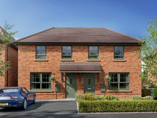 3 bedroom end of terrace house for sale in Greensleaves Avenue, Borden,
Sittingbourne,
Kent,
ME10 1FW, ME10 — £364,995 • 3 bed • 1 bath • 700 ft²
3 bedroom end of terrace house for sale in Greensleaves Avenue, Borden,
Sittingbourne,
Kent,
ME10 1FW, ME10 — £364,995 • 3 bed • 1 bath • 700 ft²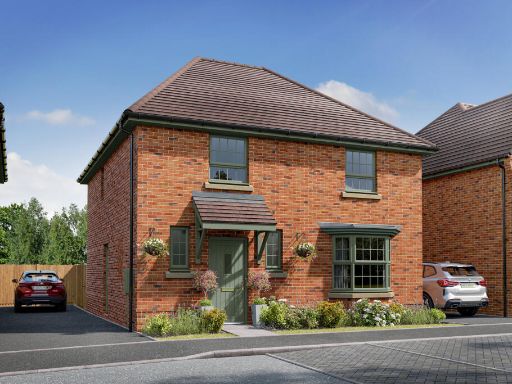 4 bedroom detached house for sale in Greensleaves Avenue, Borden,
Sittingbourne,
Kent,
ME10 1FW, ME10 — £532,995 • 4 bed • 1 bath • 1174 ft²
4 bedroom detached house for sale in Greensleaves Avenue, Borden,
Sittingbourne,
Kent,
ME10 1FW, ME10 — £532,995 • 4 bed • 1 bath • 1174 ft²
Meta
- {
"@context": "https://schema.org",
"@type": "Residence",
"name": "4 bedroom detached house for sale in PLATINUM WAY, Borden,…",
"description": "",
"url": "https://propertypiper.co.uk/property/8787dd02-a280-4a6c-a812-e0e67ac85a89",
"image": "https://image-a.propertypiper.co.uk/25ab1123-6e97-43b7-ad6e-8d0bae726895-1024.jpeg",
"address": {
"@type": "PostalAddress",
"streetAddress": "PLATINUM WAY,\r\nBorden,\r\nSittingbourne,\r\nME10",
"postalCode": "ME10 1FS",
"addressLocality": "Swale",
"addressRegion": "Sittingbourne and Sheppey",
"addressCountry": "England"
},
"geo": {
"@type": "GeoCoordinates",
"latitude": 51.34119,
"longitude": 0.70338
},
"numberOfRooms": 4,
"numberOfBathroomsTotal": 1,
"floorSize": {
"@type": "QuantitativeValue",
"value": 976,
"unitCode": "FTK"
},
"offers": {
"@type": "Offer",
"price": 454995,
"priceCurrency": "GBP",
"availability": "https://schema.org/InStock"
},
"additionalProperty": [
{
"@type": "PropertyValue",
"name": "Feature",
"value": "modern"
},
{
"@type": "PropertyValue",
"name": "Feature",
"value": "suburban"
},
{
"@type": "PropertyValue",
"name": "Feature",
"value": "detached"
},
{
"@type": "PropertyValue",
"name": "Feature",
"value": "brick"
},
{
"@type": "PropertyValue",
"name": "Feature",
"value": "two-story"
},
{
"@type": "PropertyValue",
"name": "Feature",
"value": "garage"
},
{
"@type": "PropertyValue",
"name": "Feature",
"value": "driveway"
},
{
"@type": "PropertyValue",
"name": "Feature",
"value": "family home"
},
{
"@type": "PropertyValue",
"name": "Feature",
"value": "new build"
},
{
"@type": "PropertyValue",
"name": "Feature",
"value": "low maintenance"
},
{
"@type": "PropertyValue",
"name": "Feature",
"value": "modern kitchen"
},
{
"@type": "PropertyValue",
"name": "Feature",
"value": "white cabinetry"
},
{
"@type": "PropertyValue",
"name": "Feature",
"value": "open plan"
},
{
"@type": "PropertyValue",
"name": "Feature",
"value": "dining area"
},
{
"@type": "PropertyValue",
"name": "Feature",
"value": "pendant lighting"
},
{
"@type": "PropertyValue",
"name": "Feature",
"value": "integrated appliances"
},
{
"@type": "PropertyValue",
"name": "Feature",
"value": "wooden floor"
},
{
"@type": "PropertyValue",
"name": "Feature",
"value": "contemporary design"
}
]
}
High Res Floorplan Images
Compatible Floorplan Images
FloorplanImages Thumbnail