WR10 3HA - Land for sale in Field 50, Pensham Hill, Pershore, Worceste…
View on Property Piper
Land for sale in Field 50, Pensham Hill, Pershore, Worcestershire, WR10 3HA, WR10
Property Details
- Price: £1
- Bedrooms: 1
- Bathrooms: 1
- Property Type: undefined
- Property SubType: undefined
Brochure Descriptions
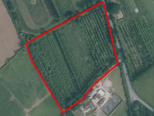
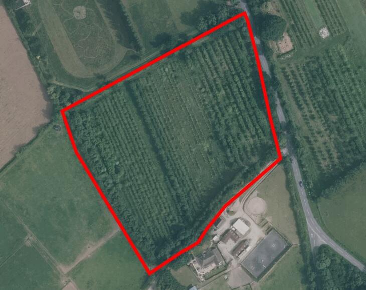
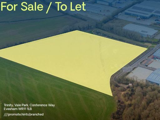
- This property spans approximately 5.69 acres offering a substantial development opportunity, ideal for industrial purposes. It is situated in a strategic location at Pensham Hill, Pershore, Worcestershire. The land is largely flat, suggesting ease for construction projects. The surrounding area is primarily rural, providing serene views and an expansive sense of space. The property's size is large, potentially accommodating significant industrial facilities or multiple units.
- The map provides a view of Pershore and surrounding areas, a location characterized by idyllic countryside with multiple farms and open landscapes. The area offers views across Pershore and River Avon, which is central to the area, possibly visible from certain properties. The residential properties in this locality may have decent proximity to natural features, with land likely average in size, suitable for either farming or spacious gardens. The overall community appears rural, with the potential for expansive and tranquil surroundings.
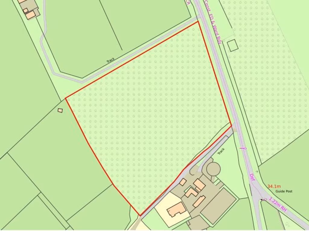
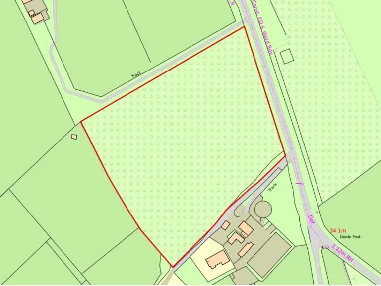
- The property is a regular-in-shape greenfield plot of agricultural land situated with gated access off Pensham Hill. The land offers a high probability of securing planning permission and is well poised for a commercial scheme development, owing to its strategic location. The surrounding offers countryside views and is exceptionally well-linked with direct access to major roads including the B4084 and M5. The land itself is large and primarily flat, suitable for various development plans within the Pershore area.
Textual Property Features
Detected Visual Features
- land
- plot
- vacant
- development opportunity
- agricultural
- investment
- expansion potential
- green space
- vacant land
- rural
- acreage
- farming
Nearby Schools
- Cropthorne-with-Charlton CofE First School
- St Barnabas CofE First and Middle School
- Norton Juxta Kempsey CofE Primary School
- Bowbrook House School
- St Andrew's CofE School and Nursery
- Twyning School
- Bredon Hancock's Endowed CofE First School
- Defford-Cum-Besford CofE School
- Fladbury CofE First School
- Overbury CofE First School
- Ashton-under-Hill First School
- Eckington CofE First School
- Elmley Castle CofE First School
- Bredon Hill Academy
- Abbey Park Middle School
- Abbey Park First and Nursery School
- Holy Redeemer Catholic Primary School
- Orchard Primary School
- Pershore High School
- Pinvin CofE First School
Nearest General Shops
- Id: 358605527
- Tags:
- HE_ref: 474342
- Addr:
- City: Pershore
- Housenumber: 18
- Postcode: WR10 1AT
- Street: Bridge Street
- Building: yes
- Listed_status: Grade II
- Name: Hairatage
- Shop: hairdresser
- Source:
- Addr:
- Postcode: code-point_open
- Listed_status: English Heritage
- TagsNormalized:
- Lat: 52.1091396
- Lon: -2.0741169
- FullGeoHash: gcq82y1ttxdm
- PartitionGeoHash: gcq8
- Images:
- FoodStandards: null
- Distance: 994.1
,- Id: 358907269
- Tags:
- HE_ref: 474369
- Addr:
- City: Pershore
- Housenumber: 40
- Postcode: WR10 1AT
- Street: Bridge Street
- Building: yes
- Listed_status: Grade II
- Name: Ian K Pugh Olde Books
- Shop: books
- Source:
- Addr:
- Postcode: code-point_open
- Listed_status: English Heritage
- TagsNormalized:
- Lat: 52.108691
- Lon: -2.073778
- FullGeoHash: gcq82y1gjkp1
- PartitionGeoHash: gcq8
- Images:
- FoodStandards: null
- Distance: 942.5
,- Id: 200945475
- Tags:
- Building: yes
- Shop: garden_centre
- TagsNormalized:
- Lat: 52.1014783
- Lon: -2.0611064
- FullGeoHash: gcq83hg1hex8
- PartitionGeoHash: gcq8
- Images:
- FoodStandards: null
- Distance: 811.8
}
Nearest Leisure Facilities
- Id: 3477138497
- Tags:
- TagsNormalized:
- picnic
- picnic table
- leisure
- Lat: 52.1041224
- Lon: -2.0708873
- FullGeoHash: gcq82vk08b6s
- PartitionGeoHash: gcq8
- Images:
- FoodStandards: null
- Distance: 451.9
,- Id: 3476873651
- Tags:
- TagsNormalized:
- picnic
- picnic table
- leisure
- Lat: 52.1035914
- Lon: -2.0710954
- FullGeoHash: gcq82v5v7vrm
- PartitionGeoHash: gcq8
- Images:
- FoodStandards: null
- Distance: 391.3
,- Id: 653357474
- Tags:
- Landuse: meadow
- Source: bing
- Sport: equestrian
- TagsNormalized:
- Lat: 52.0970765
- Lon: -2.0717216
- FullGeoHash: gcq82ggrmquq
- PartitionGeoHash: gcq8
- Images:
- FoodStandards: null
- Distance: 359.1
,- Id: 340456614
- Tags:
- Leisure: marina
- Name: Pershore Marina & Boatyard
- Seamark:
- TagsNormalized:
- Lat: 52.1018844
- Lon: -2.0724378
- FullGeoHash: gcq82ufgkxnq
- PartitionGeoHash: gcq8
- Images:
- FoodStandards: null
- Distance: 185.2
,- Id: 934823220
- Tags:
- Leisure: pitch
- Sport: tennis
- TagsNormalized:
- Lat: 52.1003591
- Lon: -2.0718718
- FullGeoHash: gcq82ue69fu7
- PartitionGeoHash: gcq8
- Images:
- FoodStandards: null
- Distance: 66.1
}
Nearest Tourist attractions
- Id: 157214359
- Tags:
- Addr:
- Name: Comberton Caravan and Camping Site
- Source: Bing
- Tourism: caravan_site
- Url: http://www.combertoncampsite.co.uk/
- TagsNormalized:
- Lat: 52.0848235
- Lon: -2.0705108
- FullGeoHash: gcq82cu21dg4
- PartitionGeoHash: gcq8
- Images:
- FoodStandards: null
- Distance: 1720.9
,- Id: 2565647849
- Tags:
- TagsNormalized:
- Lat: 52.101387
- Lon: -2.0853281
- FullGeoHash: gcq82sc8866x
- PartitionGeoHash: gcq8
- Images:
- FoodStandards: null
- Distance: 864
,- Id: 352108772
- Tags:
- HE_ref: 474144
- Bridge: yes
- Foot: yes
- Heritage: 2
- Heritage:operator: Historic England
- Highway: cycleway
- Listed_status: Grade II*
- Name: Pershore Old Bridge
- Source: survey
- Source:listed_status: English Heritage
- Tourism: attraction
- Wikidata: Q17549013
- TagsNormalized:
- Lat: 52.1045029
- Lon: -2.0708845
- FullGeoHash: gcq82vk48zkd
- PartitionGeoHash: gcq8
- Images:
- FoodStandards: null
- Distance: 492.6
}
Nearest Train stations
- Id: 966924198
- Tags:
- Public_transport: station
- Railway: station
- Usage: tourism
- Wheelchair: no
- TagsNormalized:
- Lat: 52.1141441
- Lon: -1.9348538
- FullGeoHash: gcq87zp4fss6
- PartitionGeoHash: gcq8
- Images:
- FoodStandards: null
- Distance: 9548.3
,- Id: 6309171430
- Tags:
- Addr:
- City: Evesham
- Postcode: WR11 4TP
- Street: Evesham Country Park
- Name: Evesham Vale Light Railway
- Public_transport: station
- Railway: station
- Source: Bing
- Usage: tourism
- Website: http://www.evlr.co.uk/
- TagsNormalized:
- Lat: 52.1172969
- Lon: -1.9372088
- FullGeoHash: gcq87ztm7b23
- PartitionGeoHash: gcq8
- Images:
- FoodStandards: null
- Distance: 9453.4
,- Id: 7216839133
- Tags:
- Name: Worcestershire Parkway
- Naptan:
- Network: National Rail
- Operator: Great Western Railway
- Public_transport: station
- Railway: station
- Ref:
- Train: yes
- Wheelchair: yes
- Wikipedia: en:Worcestershire Parkway railway station
- TagsNormalized:
- Lat: 52.1561771
- Lon: -2.1600339
- FullGeoHash: gcq2wyepg81g
- PartitionGeoHash: gcq2
- Images:
- FoodStandards: null
- Distance: 8610.4
,- Id: 6609023832
- Tags:
- Name: Evesham
- Naptan:
- Network: National Rail
- Public_transport: station
- Railway: station
- Ref:
- Source: NPE
- Wikidata: Q2416634
- Wikipedia: en:Evesham railway station
- TagsNormalized:
- Lat: 52.0984969
- Lon: -1.9472858
- FullGeoHash: gcq87snp8zwr
- PartitionGeoHash: gcq8
- Images:
- FoodStandards: null
- Distance: 8576.9
,- Id: 6609023816
- Tags:
- Name: Pershore
- Naptan:
- Network: National Rail
- Public_transport: station
- Railway: station
- Ref:
- Source: NPE
- Wikidata: Q2185064
- Wikipedia: en:Pershore railway station
- TagsNormalized:
- Lat: 52.1307399
- Lon: -2.0723991
- FullGeoHash: gcq88f4gtd70
- PartitionGeoHash: gcq8
- Images:
- FoodStandards: null
- Distance: 3392.1
}
Nearest Hotels
- Id: 358389711
- Tags:
- Addr:
- Postcode: WR10 1BH
- Street: Church Row
- Amenity: pub
- Building: yes
- Fhrs:
- Name: White Horse Hotel
- Source:
- Addr:
- Postcode: code-point_open
- TagsNormalized:
- Lat: 52.1111347
- Lon: -2.077196
- FullGeoHash: gcq82wx3mgd6
- PartitionGeoHash: gcq8
- Images:
- FoodStandards: null
- Distance: 1248.3
,- Id: 358549496
- Tags:
- HE_ref: 474474
- Addr:
- City: Pershore
- Housenumber: 9
- Postcode: WR10 1AF
- Street: High Street
- Amenity: pub
- Building: yes
- Fhrs:
- Listed_status: Grade II
- Name: Angel Inn
- Source:
- Addr:
- Listed_status: English Heritage
- Tourism: hotel
- Website: https://angelpershore.co.uk/
- TagsNormalized:
- Lat: 52.1102814
- Lon: -2.0743063
- FullGeoHash: gcq82y3s3ht0
- PartitionGeoHash: gcq8
- Images:
- FoodStandards: null
- Distance: 1121.7
,- Id: 358871461
- Tags:
- HE_ref: 474352
- Addr:
- City: Pershore
- Housenumber: 23
- Postcode: WR10 1AJ
- Street: Bridge Street
- Amenity: pub
- Building: yes
- Fhrs:
- Listed_status: Grade II
- Name: Star Inn Hotel
- Source:
- Addr:
- Postcode: code-point_open
- Listed_status: English Heritage
- Website: https://www.starinnatpershore.co.uk/
- TagsNormalized:
- Lat: 52.109008
- Lon: -2.0734139
- FullGeoHash: gcq82y4hvzns
- PartitionGeoHash: gcq8
- Images:
- FoodStandards: null
- Distance: 976.3
}
Tags
- land
- plot
- vacant
- development opportunity
- agricultural
- investment
- expansion potential
- land
- plot
- agricultural
- development opportunity
- green space
- investment
- vacant land
- rural
- acreage
- farming
Local Market Stats
- Average Price/sqft: £307
- Avg Income: £45100
- Rental Yield: 3.4%
- Social Housing: 10%
- Planning Success Rate: 87%
AirBnB Data
- 1km average: £94/night
- Listings in 1km: 2
Similar Properties
 Commercial development for sale in Development Land, Trinity, Vale Park, Conference Way, Evesham WR11 1LB, WR11 — POA • 1 bed • 1 bath
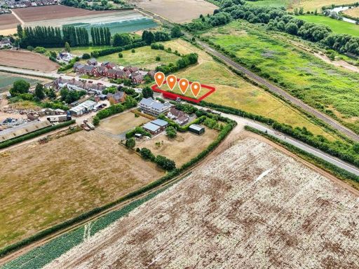 Plot for sale in Land at Evesham Road, Upper Moor, Pershore, WR10 — £500,000 • 1 bed • 1 bath • 1564 ft²
 Commercial development for sale in Land At Willow End Park, Malvern , WR13 — £255,000 • 1 bed • 1 bath • 27878 ft²
 Land for sale in Land and Buildings at Haselor Farm, Pershore Road, Hinton-on-the-green, Evesham, WR11 — £250,000 • 1 bed • 1 bath
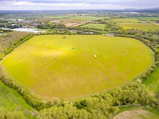 Land for sale in Land Off Birmingham Road, Blackminster, Evesham, WR11 — £400,000 • 1 bed • 1 bath
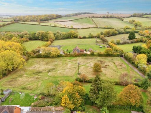 Land for sale in Low Road, Church Lench, WR11 — £1,800,000 • 1 bed • 1 bath • 18266 ft²
Meta
- {
"@context": "https://schema.org",
"@type": "Residence",
"name": "Land for sale in Field 50, Pensham Hill, Pershore, Worceste…",
"description": "",
"url": "https://propertypiper.co.uk/property/876a95ec-58c2-4301-894f-f6c7d91951f3",
"image": "https://image-a.propertypiper.co.uk/d213e5ba-830f-4370-b74d-2cc4d5e4af71-1024.jpeg",
"address": {
"@type": "PostalAddress",
"streetAddress": "1, PENSHAM HILL, PERSHORE",
"postalCode": "WR10 3HA",
"addressLocality": "Wychavon",
"addressRegion": "West Worcestershire",
"addressCountry": "England"
},
"geo": {
"@type": "GeoCoordinates",
"latitude": 52.1002351,
"longitude": -2.0728184
},
"numberOfRooms": 1,
"numberOfBathroomsTotal": 1,
"offers": {
"@type": "Offer",
"price": 1,
"priceCurrency": "GBP",
"availability": "https://schema.org/InStock"
},
"additionalProperty": [
{
"@type": "PropertyValue",
"name": "Feature",
"value": "land"
},
{
"@type": "PropertyValue",
"name": "Feature",
"value": "plot"
},
{
"@type": "PropertyValue",
"name": "Feature",
"value": "vacant"
},
{
"@type": "PropertyValue",
"name": "Feature",
"value": "development opportunity"
},
{
"@type": "PropertyValue",
"name": "Feature",
"value": "agricultural"
},
{
"@type": "PropertyValue",
"name": "Feature",
"value": "investment"
},
{
"@type": "PropertyValue",
"name": "Feature",
"value": "expansion potential"
},
{
"@type": "PropertyValue",
"name": "Feature",
"value": "land"
},
{
"@type": "PropertyValue",
"name": "Feature",
"value": "plot"
},
{
"@type": "PropertyValue",
"name": "Feature",
"value": "agricultural"
},
{
"@type": "PropertyValue",
"name": "Feature",
"value": "development opportunity"
},
{
"@type": "PropertyValue",
"name": "Feature",
"value": "green space"
},
{
"@type": "PropertyValue",
"name": "Feature",
"value": "investment"
},
{
"@type": "PropertyValue",
"name": "Feature",
"value": "vacant land"
},
{
"@type": "PropertyValue",
"name": "Feature",
"value": "rural"
},
{
"@type": "PropertyValue",
"name": "Feature",
"value": "acreage"
},
{
"@type": "PropertyValue",
"name": "Feature",
"value": "farming"
}
]
}