HR1 3EY - Land for sale in Marden, Hereford, HR1
View on Property Piper
Land for sale in Marden, Hereford, HR1
Property Details
- Price: £220000
- Bedrooms: 1
- Bathrooms: 1
- Property Type: undefined
- Property SubType: undefined
Brochure Descriptions
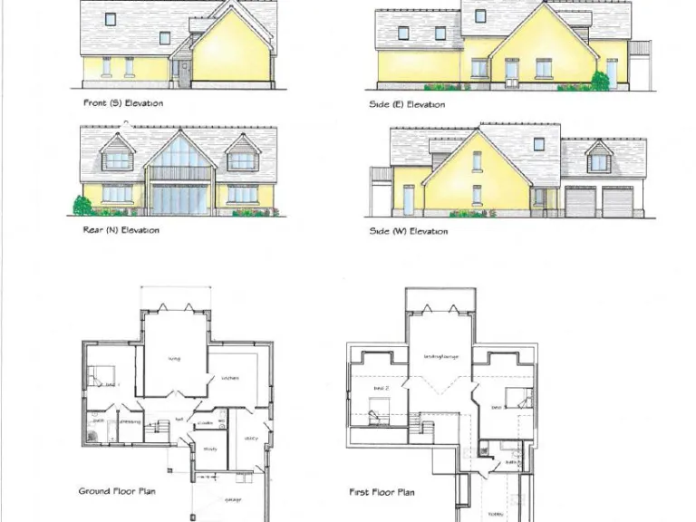
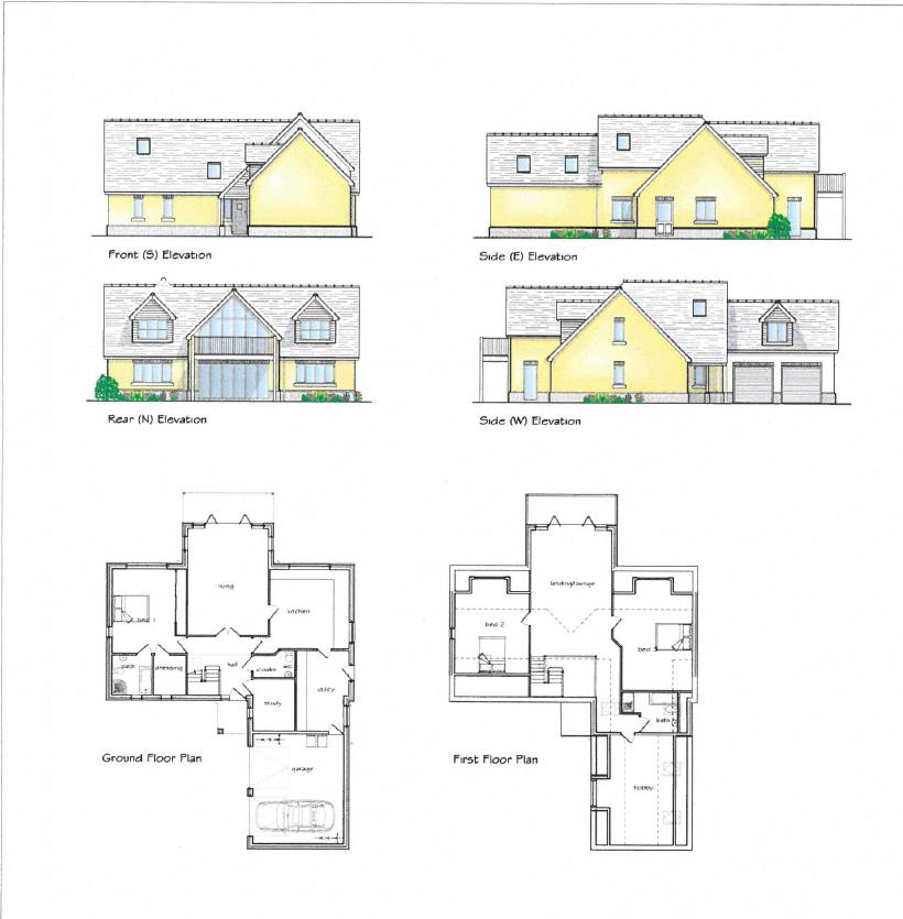
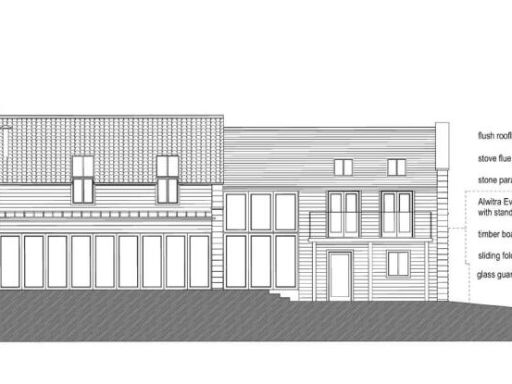
- The property is a new build plot featuring a modern, detached dwelling with a well-planned two-storey design. The exterior illustrates a contemporary architectural style, accentuated with a pitched roof and dual garages, suggesting ample parking and storage space. Based on the visual representation, it is likely to feature spacious interiors given the plot configuration and the positioning of windows which indicate natural light optimization. The plot offers potential for a sizable garden. Given the setting in Marden, it's reasonable to deduce a tranquil countryside location with potential scenic views.
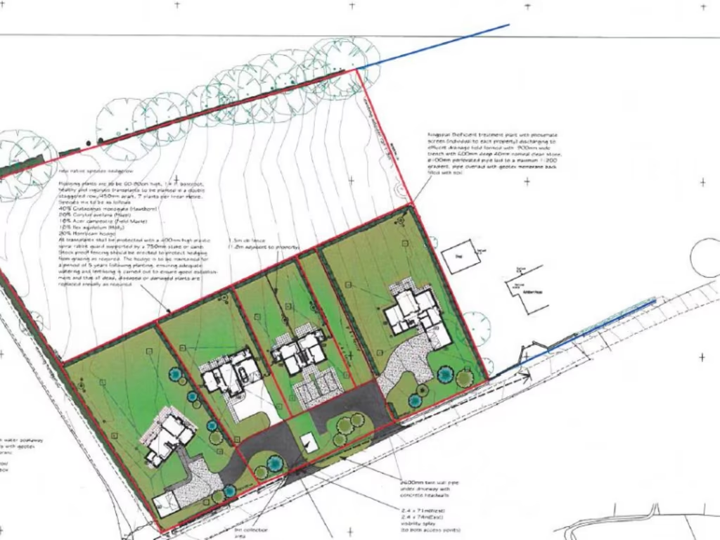
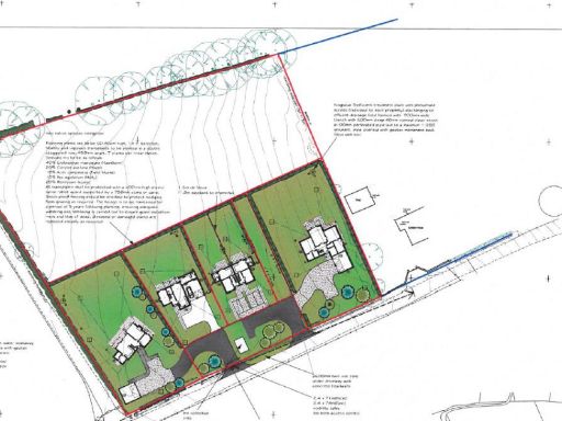
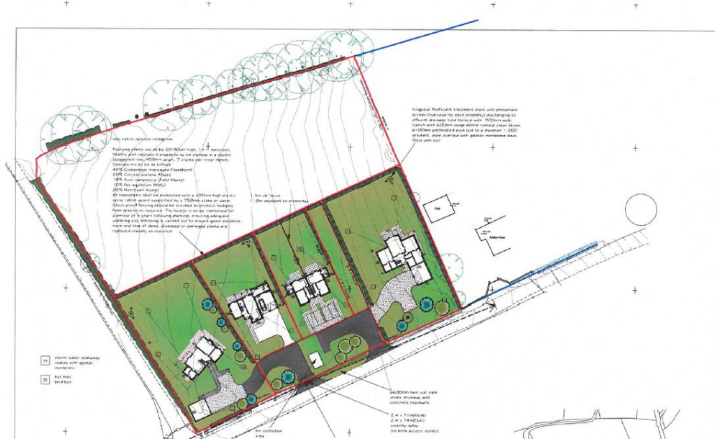
- The property for sale is a freehold building plot in a highly sought-after location offering a rare opportunity to build a very individual detached house with around 3,500 sq. ft of living space, including garage space. The plot is part of "The Hedgerow," a potential development of individual houses and cottages in a small hamlet, away from main roads. The proposed accommodation includes three or four bedrooms, a master bedroom with ensuite and dressing room, a large kitchen with separate utility room, ground and first floor living rooms, and connections to mains electricity and water. The plot is generous in size, allowing for a spacious home.
Image Descriptions
- two-story modern house Modern
- development plan contemporary
Textual Property Features
Detected Visual Features
- modern
- two-story
- detached
- garage
- garden
- floor plan
- elevations
- new build
- family home
- development plan
- contemporary style
- residential development
- plot layout
- green space
- modern design
Nearby Schools
- Withington Primary School
- Burghill Community Academy
- Canon Pyon CofE Academy
- Sutton Primary Academy
- St Michael's CofE Primary School
- Pencombe CofE Primary School
- Ivington CofE Primary and Pre-School
- Burley Gate CofE Primary School
- Marden Primary Academy
- Stoke Prior Primary School
Nearest Bars And Restaurants
- Id: 155212216
- Tags:
- Amenity: pub
- Name: The Cross Keys
- TagsNormalized:
- Lat: 52.0947174
- Lon: -2.6540862
- FullGeoHash: gcq07ee3er1v
- PartitionGeoHash: gcq0
- Images:
- FoodStandards: null
- Distance: 6327.7
,- Id: 498822970
- Tags:
- Addr:
- Amenity: pub
- Building: yes
- Name: The Golden Cross
- Website: https://www.goldencrossinn.com/
- TagsNormalized:
- Lat: 52.1061022
- Lon: -2.6837567
- FullGeoHash: gcq06vtspcmy
- PartitionGeoHash: gcq0
- Images:
- FoodStandards: null
- Distance: 4582.2
,- Id: 487228202
- Tags:
- Amenity: pub
- Name: Amberley Arms
- TagsNormalized:
- Lat: 52.1249135
- Lon: -2.6726961
- FullGeoHash: gcq0e1jc9sjk
- PartitionGeoHash: gcq0
- Images:
- FoodStandards: null
- Distance: 2743.7
,- Id: 319313124
- Tags:
- Amenity: cafe
- Building: yes
- Source: Bing;local_knowledge
- TagsNormalized:
- Lat: 52.1589654
- Lon: -2.7226551
- FullGeoHash: gcq0dp1rvxch
- PartitionGeoHash: gcq0
- Images:
- FoodStandards: null
- Distance: 2575
,- Id: 958071792
- Tags:
- Amenity: cafe
- Building: yes
- Name: Golf Club & Tea Room
- Source: Bing
- TagsNormalized:
- Lat: 52.1574345
- Lon: -2.6652919
- FullGeoHash: gcq0eqgpn4qr
- PartitionGeoHash: gcq0
- Images:
- FoodStandards: null
- Distance: 2051.6
}
Nearest General Shops
- Id: 597866214
- Tags:
- Building: industrial
- Shop: car_repair
- Source: Bing
- TagsNormalized:
- industrial
- car repair
- repair
- shop
- Lat: 52.1315979
- Lon: -2.7249115
- FullGeoHash: gcq09frb8fnw
- PartitionGeoHash: gcq0
- Images:
- FoodStandards: null
- Distance: 2929.6
,- Id: 8901974317
- Tags:
- Name: A49 Auto Repairs
- Phone: +44 1568 797 416
- Shop: car_repair
- TagsNormalized:
- Lat: 52.1467874
- Lon: -2.7276368
- FullGeoHash: gcq09vjc13wx
- PartitionGeoHash: gcq0
- Images:
- FoodStandards: null
- Distance: 2553.1
,- Id: 958071789
- Tags:
- Building: yes
- Name: Saffrons Cross Garage
- Shop: car_repair
- Source: Bing
- TagsNormalized:
- garage
- car repair
- repair
- shop
- Lat: 52.1613106
- Lon: -2.6734269
- FullGeoHash: gcq0eptm8th3
- PartitionGeoHash: gcq0
- Images:
- FoodStandards: null
- Distance: 1950.2
}
Nearest Grocery shops
- Id: 4685562617
- Tags:
- Amenity: fast_food
- Name: Village chip shop
- TagsNormalized:
- Lat: 52.1073059
- Lon: -2.7234655
- FullGeoHash: gcq06jbg49ug
- PartitionGeoHash: gcq0
- Images:
- FoodStandards: null
- Distance: 4974.7
,- Id: 498820882
- Tags:
- Building: yes
- Name: Moreton village stores
- Shop: convenience
- TagsNormalized:
- Lat: 52.1073064
- Lon: -2.7222745
- FullGeoHash: gcq06jcen3vn
- PartitionGeoHash: gcq0
- Images:
- FoodStandards: null
- Distance: 4938.1
,- Id: 4598751386
- Tags:
- Name: Marden Mini Market
- Shop: convenience
- TagsNormalized:
- Lat: 52.1239537
- Lon: -2.6996084
- FullGeoHash: gcq0d8fhn94p
- PartitionGeoHash: gcq0
- Images:
- FoodStandards: null
- Distance: 2654.3
}
Nearest Supermarkets
- Id: 288716847
- Tags:
- Addr:
- Postcode: HR6 8RN
- Street: Barons Cross Road
- Alt_name: Morrisons Leominster
- Brand: Morrisons
- Brand:wikidata: Q922344
- Brand:wikipedia: en:Morrisons
- Building: yes
- Contact:
- Website: https://my.morrisons.com/storefinder/252
- Name: Morrisons
- Shop: supermarket
- TagsNormalized:
- Lat: 52.2235582
- Lon: -2.7567854
- FullGeoHash: gcq1170860zg
- PartitionGeoHash: gcq1
- Images:
- FoodStandards: null
- Distance: 9635.1
,- Id: 288716849
- Tags:
- Addr:
- City: Leominster
- Postcode: HR6 8NY
- Street: Dishley Street
- Alt_name: ALDI Leominster
- Brand: ALDI
- Brand:wikidata: Q41171672
- Brand:wikipedia: en:Aldi
- Building: yes
- Contact:
- Website: https://stores.aldi.co.uk/leominster/dishley-street
- Name: ALDI
- Shop: supermarket
- TagsNormalized:
- Lat: 52.2253011
- Lon: -2.7404374
- FullGeoHash: gcq11ek6rjtz
- PartitionGeoHash: gcq1
- Images:
- FoodStandards: null
- Distance: 9343.1
,- Id: 722997288
- Tags:
- Addr:
- Place: Salmon Retail Park
- Postcode: HR4 9SA
- Street: Holmer Road
- Unit: Unit 1
- Brand:
- Building: retail
- Fhrs:
- Name: B&M Home Store
- Shop: supermarket
- Source:
- TagsNormalized:
- Lat: 52.0678947
- Lon: -2.7210774
- FullGeoHash: gcq04ndt6r1d
- PartitionGeoHash: gcq0
- Images:
- FoodStandards:
- Id: 487704
- FHRSID: 487704
- LocalAuthorityBusinessID: 154415
- BusinessName: B & M Home Store
- BusinessType: Retailers - other
- BusinessTypeID: 4613
- AddressLine1: B&M
- AddressLine2: Unit 1 Salmon Retail Park
- AddressLine3: null
- AddressLine4: Holmer Road
- PostCode: HR4 9SA
- RatingValue: 5
- RatingKey: fhrs_5_en-GB
- RatingDate: 2012-05-22
- LocalAuthorityCode: 895
- LocalAuthorityName: Herefordshire
- LocalAuthorityWebSite: http://www.herefordshire.gov.uk/
- LocalAuthorityEmailAddress: info@herefordshire.gov.uk
- Scores:
- Hygiene: 0
- Structural: 5
- ConfidenceInManagement: 0
- NewRatingPending: false
- Geocode:
- Longitude: -2.72160100936890
- Latitude: 52.06663513183590
- Distance: 9057.9
}
Nearest Religious buildings
- Id: 636894045
- Tags:
- Amenity: place_of_worship
- Building: church
- Name: Marden Chapel
- Religion: christian
- TagsNormalized:
- place of worship
- church
- chapel
- christian
- Lat: 52.126849
- Lon: -2.6895548
- FullGeoHash: gcq0dc3sbufw
- PartitionGeoHash: gcq0
- Images:
- FoodStandards: null
- Distance: 2254.4
,- Id: 2217363760
- Tags:
- Amenity: place_of_worship
- Name: Bodenham Christian Fellowship
- Religion: christian
- TagsNormalized:
- place of worship
- christian
- church
- Lat: 52.1516172
- Lon: -2.666209
- FullGeoHash: gcq0emft0y46
- PartitionGeoHash: gcq0
- Images:
- FoodStandards: null
- Distance: 1713.2
,- Id: 406972383
- Tags:
- Amenity: place_of_worship
- Building: church
- Denomination: anglican
- Name: St Michael and All Angels
- Religion: christian
- Wikidata: Q17540096
- TagsNormalized:
- place of worship
- church
- anglican
- christian
- Lat: 52.1542728
- Lon: -2.6885113
- FullGeoHash: gcq0dy6k9jhe
- PartitionGeoHash: gcq0
- Images:
- FoodStandards: null
- Distance: 804
}
Nearest Medical buildings
- Id: 1588992719
- Tags:
- Addr:
- City: Leominster
- Postcode: HR6 8JH
- Street: South Street
- Amenity: hospital
- Healthcare: hospital
- Name: Leominster Community Hospital
- Operator: Wye Valley NHS Trust
- Source: OS_OpenData_StreetView
- TagsNormalized:
- Lat: 52.223206
- Lon: -2.738751
- FullGeoHash: gcq11dvwnrpn
- PartitionGeoHash: gcq1
- Images:
- FoodStandards: null
- Distance: 9084.3
,- Id: 357397490
- Tags:
- Amenity: hospital
- Healthcare: hospital
- TagsNormalized:
- Lat: 52.2230756
- Lon: -2.7388958
- FullGeoHash: gcq11dvt7ngk
- PartitionGeoHash: gcq1
- Images:
- FoodStandards: null
- Distance: 9074.4
,- Id: 772155308
- Tags:
- Amenity: doctors
- Name: Bobblestock Surgery
- TagsNormalized:
- Lat: 52.0737091
- Lon: -2.7441106
- FullGeoHash: gcq01x9z3dfy
- PartitionGeoHash: gcq0
- Images:
- FoodStandards: null
- Distance: 8954
,- Id: 2217363759
- Tags:
- TagsNormalized:
- Lat: 52.1549656
- Lon: -2.6678012
- FullGeoHash: gcq0eq92ewr0
- PartitionGeoHash: gcq0
- Images:
- FoodStandards: null
- Distance: 1761.2
}
Nearest Leisure Facilities
- Id: 796903048
- Tags:
- Landuse: meadow
- Source: bing
- Sport: equestrian
- TagsNormalized:
- Lat: 52.1381323
- Lon: -2.6881854
- FullGeoHash: gcq0dg6w8sr9
- PartitionGeoHash: gcq0
- Images:
- FoodStandards: null
- Distance: 1009
,- Id: 796907147
- Tags:
- Leisure: pitch
- Source: bing
- Sport: equestrian
- TagsNormalized:
- pitch
- leisure
- equestrian
- sports
- Lat: 52.1410146
- Lon: -2.6808737
- FullGeoHash: gcq0dgzz7jee
- PartitionGeoHash: gcq0
- Images:
- FoodStandards: null
- Distance: 931.6
,- Id: 796907148
- Tags:
- Landuse: meadow
- Source: bing
- Sport: equestrian
- TagsNormalized:
- Lat: 52.1414327
- Lon: -2.6822895
- FullGeoHash: gcq0duncf5ec
- PartitionGeoHash: gcq0
- Images:
- FoodStandards: null
- Distance: 832.5
,- Id: 796795167
- Tags:
- Landuse: meadow
- Source: bing
- Sport: equestrian
- TagsNormalized:
- Lat: 52.1452105
- Lon: -2.6986269
- FullGeoHash: gcq0dsdzv7vb
- PartitionGeoHash: gcq0
- Images:
- FoodStandards: null
- Distance: 611.4
,- Id: 796795166
- Tags:
- Landuse: meadow
- Source: bing
- Sport: equestrian
- TagsNormalized:
- Lat: 52.1464466
- Lon: -2.6964636
- FullGeoHash: gcq0dsurpf5n
- PartitionGeoHash: gcq0
- Images:
- FoodStandards: null
- Distance: 432.3
}
Nearest Tourist attractions
- Id: 474468521
- Tags:
- Addr:
- City: Moreton-on-lugg
- Postcode: HR4 8AH
- Street: A49
- Fee: yes
- Internet_access: yes
- Name: Cuckoo's Corner Caravan Site
- Tourism: camp_site
- Website: https://www.cuckooscorner.com/
- TagsNormalized:
- Lat: 52.1059424
- Lon: -2.7304423
- FullGeoHash: gcq03veg05dt
- PartitionGeoHash: gcq0
- Images:
- FoodStandards: null
- Distance: 5338.7
,- Id: 946092003
- Tags:
- Addr:
- Amenity: pub
- Building: yes
- Name: England's Gate
- Phone: +44 1568 797286
- Source: Bing
- Tourism: guest_house
- TagsNormalized:
- Lat: 52.1576269
- Lon: -2.669026
- FullGeoHash: gcq0er02pnmg
- PartitionGeoHash: gcq0
- Images:
- FoodStandards: null
- Distance: 1859.2
,- Id: 224025061
- Tags:
- Building: house
- Name: The Forge
- Tourism: guest_house
- TagsNormalized:
- Lat: 52.1562237
- Lon: -2.6820724
- FullGeoHash: gcq0dyybp0vc
- PartitionGeoHash: gcq0
- Images:
- FoodStandards: null
- Distance: 1155.1
}
Nearest Hotels
- Id: 1754267865
- Tags:
- Name: Talbot Hotel
- Tourism: hotel
- Wikidata: Q26547108
- TagsNormalized:
- Lat: 52.2266291
- Lon: -2.7391447
- FullGeoHash: gcq11et6jm39
- PartitionGeoHash: gcq1
- Images:
- FoodStandards: null
- Distance: 9449.2
,- Id: 210273558
- Tags:
- Amenity: pub
- Building: pub
- Name: The Godwins
- Source: survey
- Tourism: hotel
- Wikidata: Q26474307
- TagsNormalized:
- Lat: 52.0674877
- Lon: -2.6427083
- FullGeoHash: gcq05yeeh7jy
- PartitionGeoHash: gcq0
- Images:
- FoodStandards: null
- Distance: 9430.5
,- Id: 592454549
- Tags:
- Brand: Premier Inn
- Brand:wikidata: Q2108626
- Brand:wikipedia: en:Premier Inn
- Building: yes
- Name: Premier Inn
- Source: DigitalGlobe-Standard
- Tourism: hotel
- TagsNormalized:
- Lat: 52.0742682
- Lon: -2.7225525
- FullGeoHash: gcq04pc6xgjt
- PartitionGeoHash: gcq0
- Images:
- FoodStandards: null
- Distance: 8396.1
}
Tags
- modern
- two-story
- detached
- garage
- garden
- floor plan
- elevations
- new build
- family home
- development plan
- contemporary style
- new build
- residential development
- plot layout
- green space
- modern design
Local Market Stats
- Average Price/sqft: £272
- Avg Income: £46200
- Rental Yield: 3.3%
- Social Housing: 6%
- Planning Success Rate: 89%
Similar Properties
 Plot for sale in Church Way, Holmer, Hereford, HR1 — £225,000 • 4 bed • 2 bath
 Plot for sale in Grafton, Hereford, HR2 — £150,000 • 1 bed • 1 bath • 2075 ft²
 Land for sale in Graftonbury Lane, Herefordshire, HR2 — £99,000 • 1 bed • 1 bath • 1200 ft²
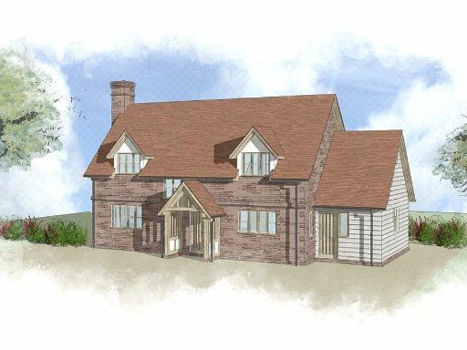 Land for sale in Great House Orchard, Dilwyn, Hereford, HR4 — £240,000 • 1 bed • 1 bath • 2054 ft²
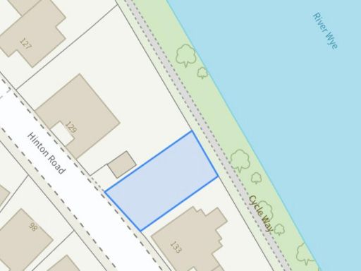 Land for sale in Hinton Road, Hereford, HR2 — £120,000 • 1 bed • 1 bath
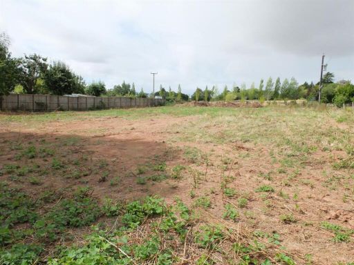 Land for sale in Building Plots, Much Cowarne, Ledbury, Herefordshire, HR7 4JH, HR7 — £230,000 • 1 bed • 1 bath • 21528 ft²
Meta
- {
"@context": "https://schema.org",
"@type": "Residence",
"name": "Land for sale in Marden, Hereford, HR1",
"description": "",
"url": "https://propertypiper.co.uk/property/846a1a30-f760-4a78-89b1-e4a3ebc8e442",
"image": "https://image-a.propertypiper.co.uk/4cb7d9df-f992-459b-889b-8c42b1e769b6-1024.jpeg",
"address": {
"@type": "PostalAddress",
"streetAddress": "Mulberry House, Litmarsh, Marden, Hereford",
"postalCode": "HR1 3EY",
"addressLocality": "Herefordshire, County of",
"addressRegion": "North Herefordshire",
"addressCountry": "England"
},
"geo": {
"@type": "GeoCoordinates",
"latitude": 52.14711940058998,
"longitude": -2.6902242652044213
},
"numberOfRooms": 1,
"numberOfBathroomsTotal": 1,
"floorSize": {
"@type": "QuantitativeValue",
"value": 3500,
"unitCode": "FTK"
},
"offers": {
"@type": "Offer",
"price": 220000,
"priceCurrency": "GBP",
"availability": "https://schema.org/InStock"
},
"additionalProperty": [
{
"@type": "PropertyValue",
"name": "Feature",
"value": "modern"
},
{
"@type": "PropertyValue",
"name": "Feature",
"value": "two-story"
},
{
"@type": "PropertyValue",
"name": "Feature",
"value": "detached"
},
{
"@type": "PropertyValue",
"name": "Feature",
"value": "garage"
},
{
"@type": "PropertyValue",
"name": "Feature",
"value": "garden"
},
{
"@type": "PropertyValue",
"name": "Feature",
"value": "floor plan"
},
{
"@type": "PropertyValue",
"name": "Feature",
"value": "elevations"
},
{
"@type": "PropertyValue",
"name": "Feature",
"value": "new build"
},
{
"@type": "PropertyValue",
"name": "Feature",
"value": "family home"
},
{
"@type": "PropertyValue",
"name": "Feature",
"value": "development plan"
},
{
"@type": "PropertyValue",
"name": "Feature",
"value": "contemporary style"
},
{
"@type": "PropertyValue",
"name": "Feature",
"value": "new build"
},
{
"@type": "PropertyValue",
"name": "Feature",
"value": "residential development"
},
{
"@type": "PropertyValue",
"name": "Feature",
"value": "plot layout"
},
{
"@type": "PropertyValue",
"name": "Feature",
"value": "green space"
},
{
"@type": "PropertyValue",
"name": "Feature",
"value": "modern design"
}
]
}