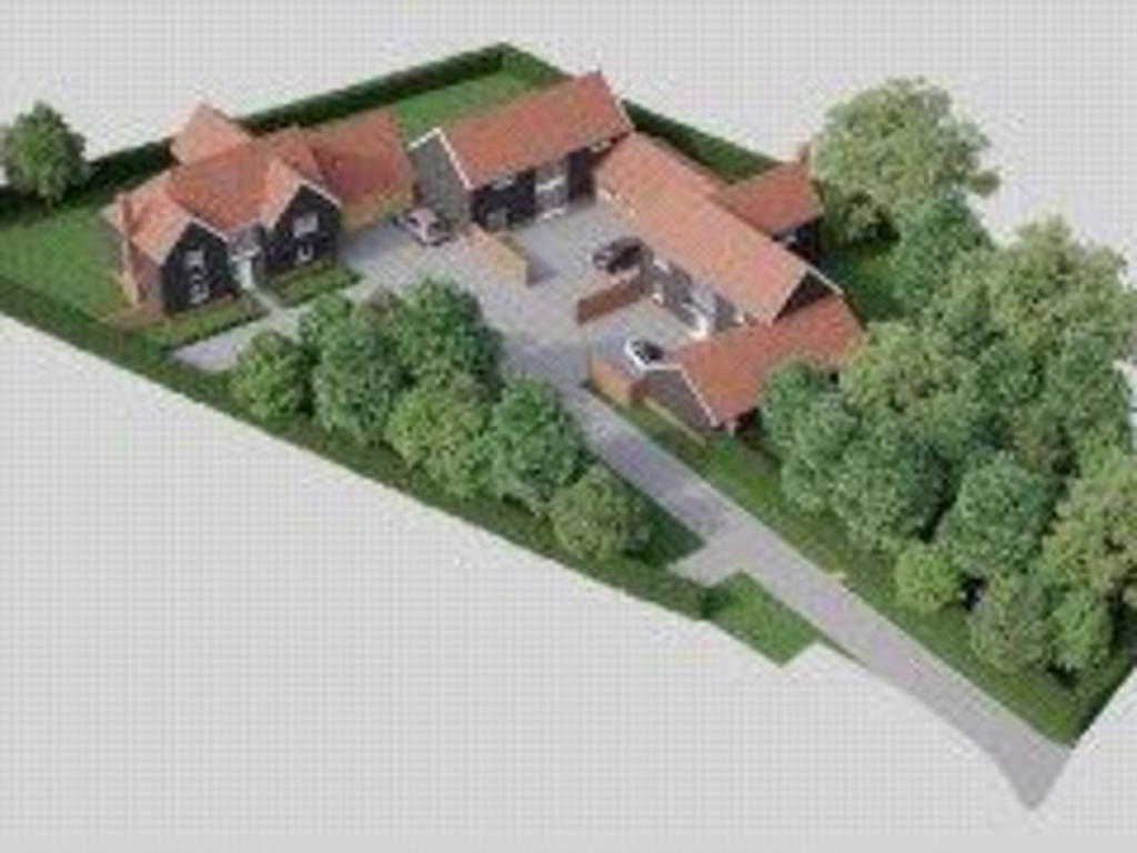
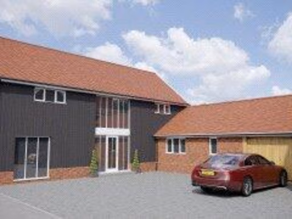
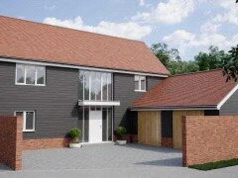
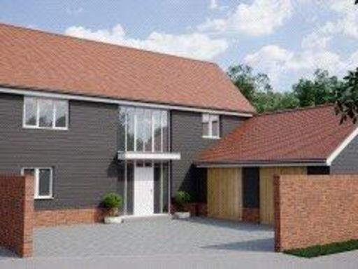
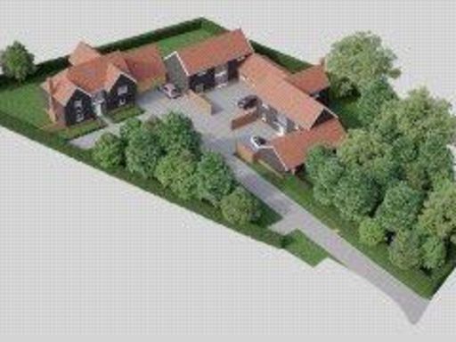
IP6 9TG - Plot for sale in Church Road, Crowfield, Ipswich, Suffolk,…
View on Property Piper
Plot for sale in Church Road, Crowfield, Ipswich, Suffolk, IP6
Property Details
- Price: £199000
- Bedrooms: 4
- Bathrooms: 3
- Property Type: undefined
- Property SubType: undefined
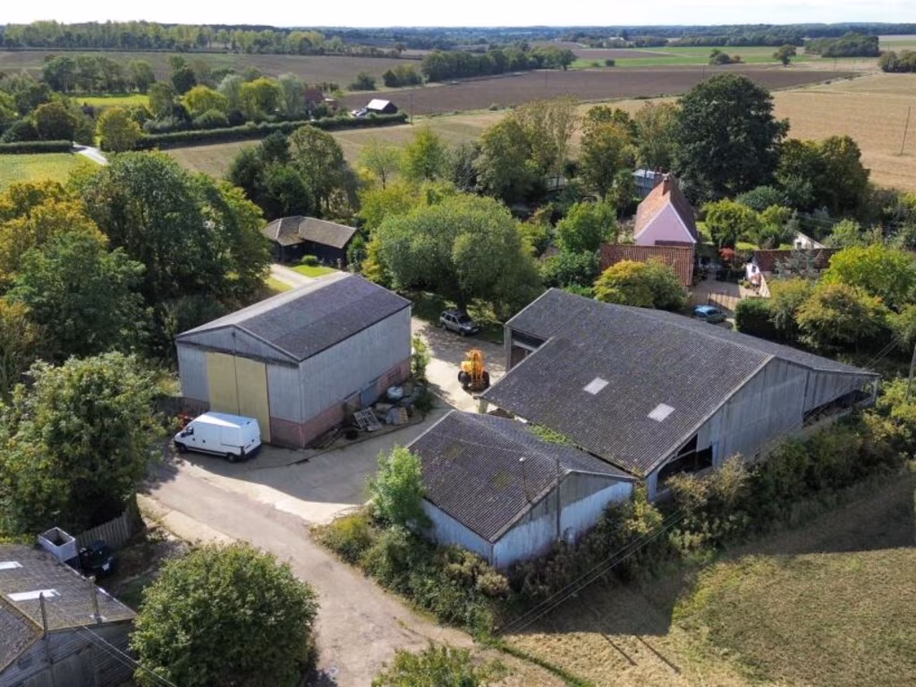
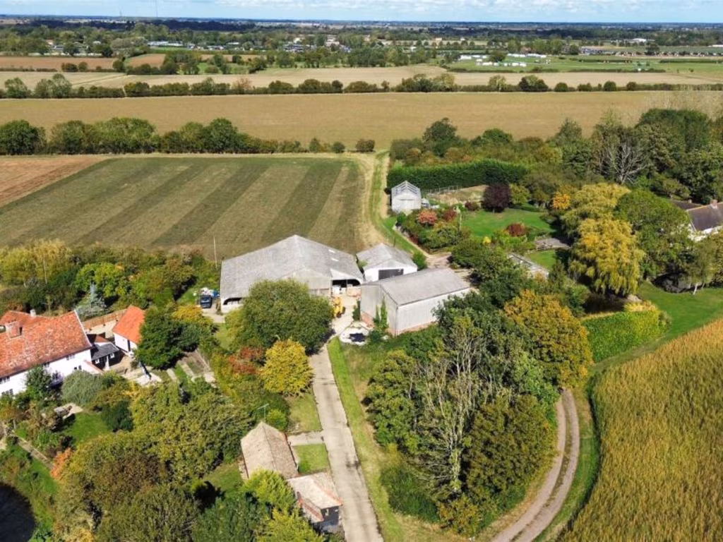
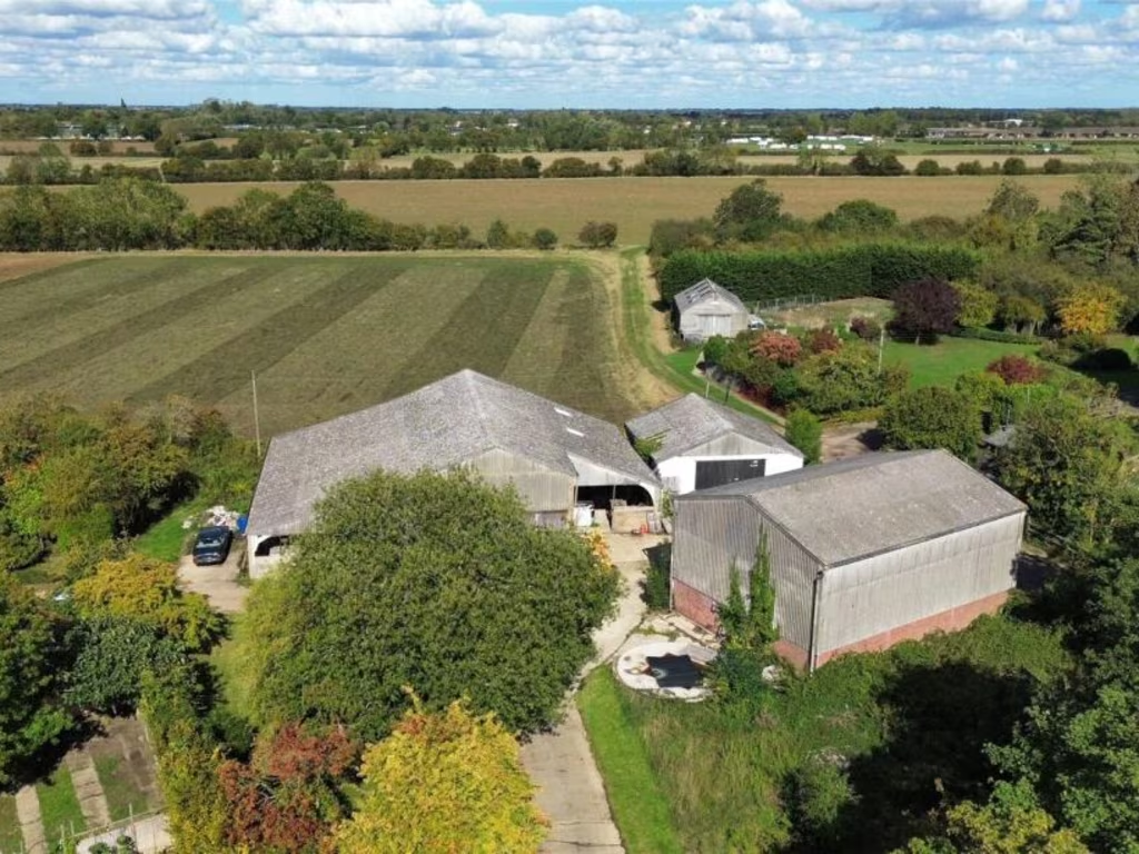
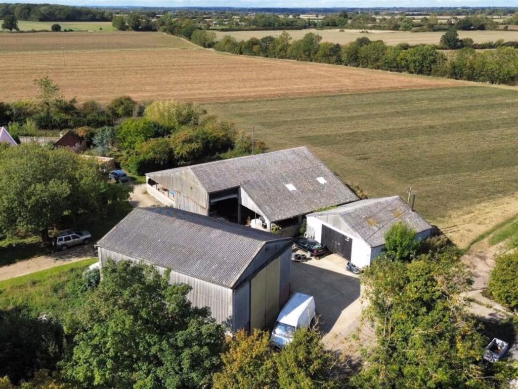
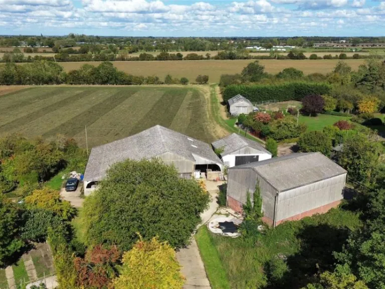
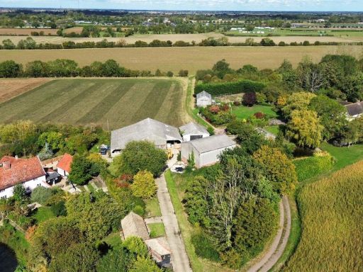
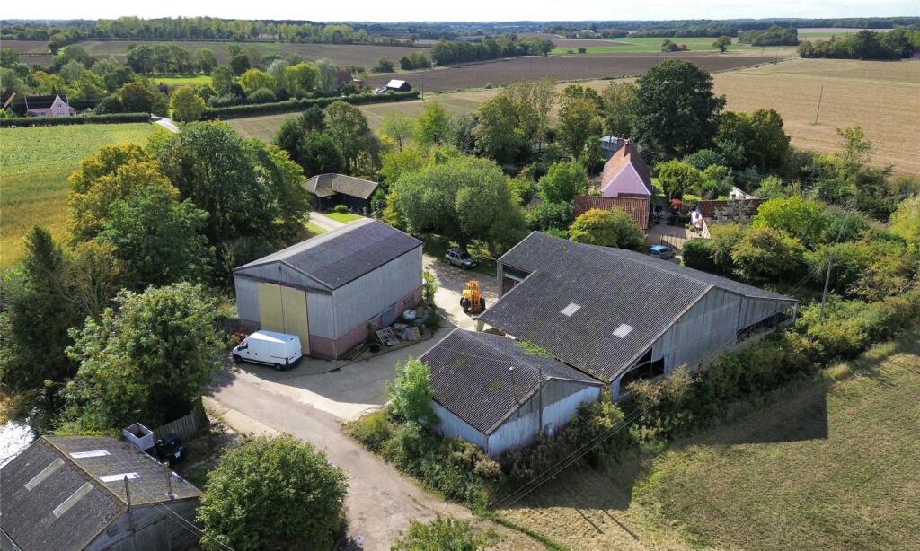
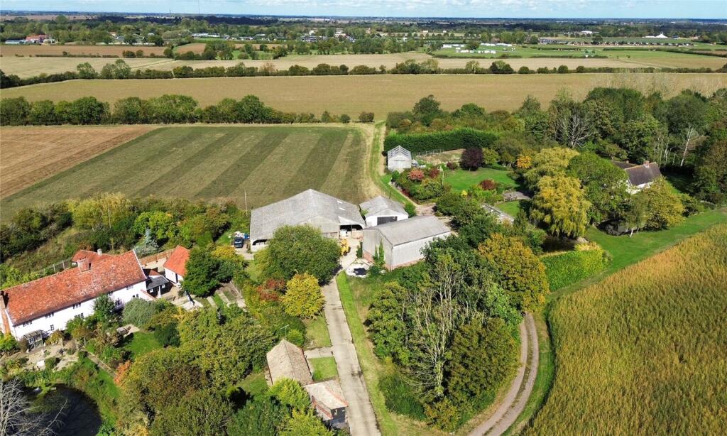
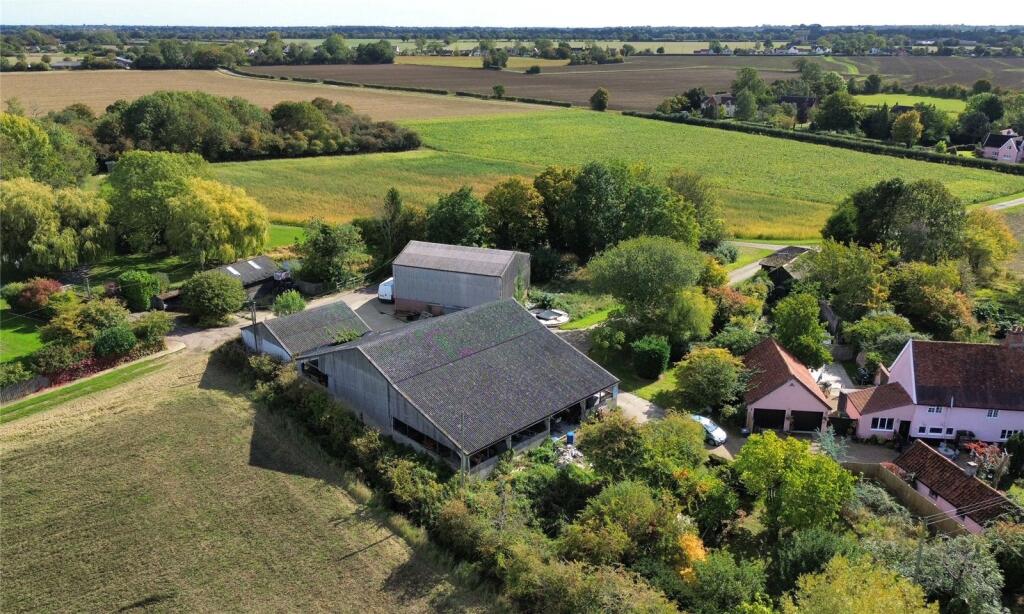
Image Descriptions
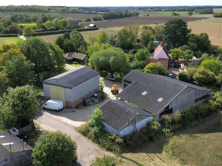
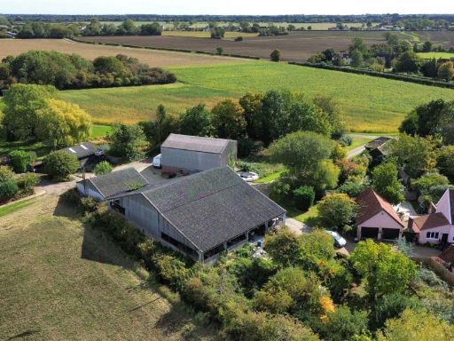
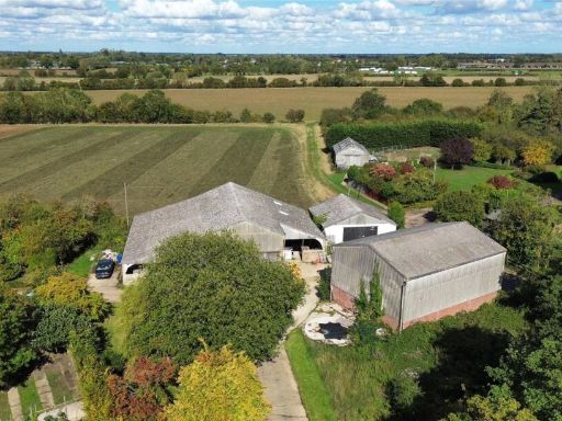
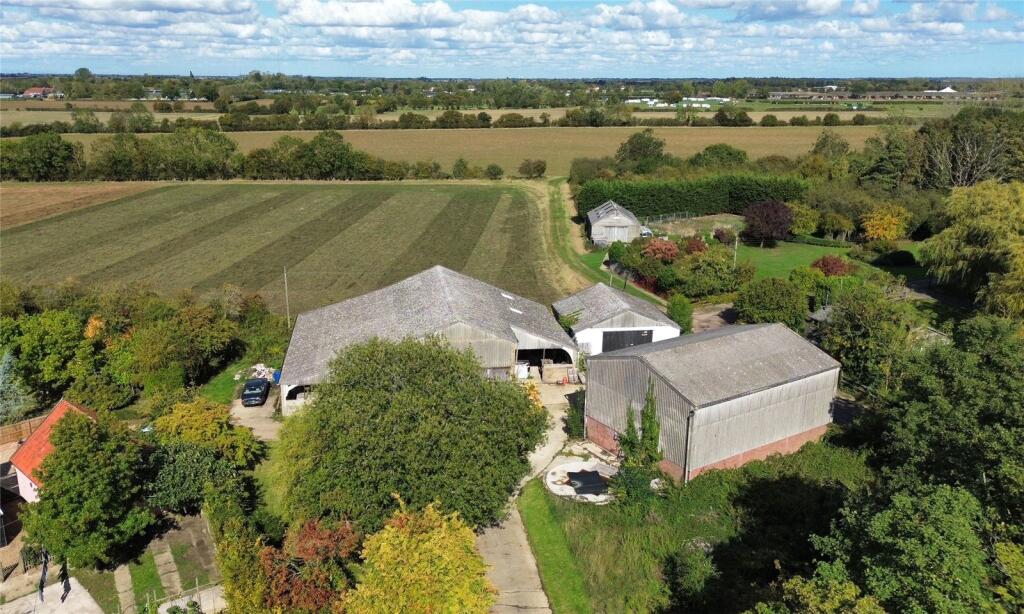
- rural property with outbuildings agricultural
- farm property agricultural
Textual Property Features
Detected Visual Features
- rural
- countryside
- outbuildings
- barn
- farm
- farming
- farmland
- agricultural
- storage
- shed
- workshop
- expansive land
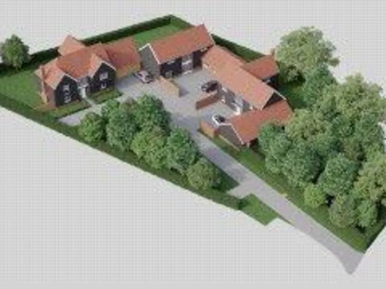
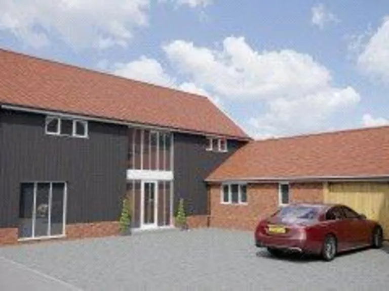
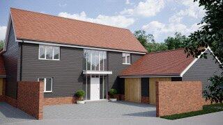
- potential development
- land
- fields
- expansive
- garden
- greenhouse
Nearby Schools
- Henley Primary School
- Stonham Aspal Church of England Voluntary Aided Primary School
- Sir Robert Hitcham Church of England Voluntary Aided School
- Claydon Primary School
- Witnesham Primary School
- Freeman Community Primary School
- Debenham High School
- Claydon High School
- Otley Primary School
- Creeting St Mary Church of England Voluntary Aided Primary School
- Helmingham Primary School and Nursery
- Mendlesham Primary School
- Bosmere Community Primary School
Nearest General Shops
- Id: 3884078577
- Tags:
- Name: Whitegate Farm Shop
- Shop: farm
- TagsNormalized:
- Lat: 52.1727512
- Lon: 1.1001704
- FullGeoHash: u12bc1c07cdx
- PartitionGeoHash: u12b
- Images:
- FoodStandards: null
- Distance: 2800.5
,- Id: 7865709493
- Tags:
- Addr:
- City: Ipswich
- Housename: The Old School
- Street: Cooper Road
- Village: Gosbeck
- Description: 10dB Acoustics is an acoustics consultancy offering a range of services. The company is sensitive to the customer’s need to resolve noise problems.
- Email: gordon@10db.co.uk
- Name: 10dB Acoustics
- Phone: +44 1449 760689
- Shop: electronics
- Website: http://10db.co.uk/
- TagsNormalized:
- Lat: 52.1553465
- Lon: 1.1421979
- FullGeoHash: u12b9yxdzjk2
- PartitionGeoHash: u12b
- Images:
- FoodStandards: null
- Distance: 2665.8
,- Id: 487690500
- Tags:
- Addr:
- City: Stowmarket
- Housename: Stonham Barns
- Postcode: IP14 6AT
- Street: Pettaugh Road
- Village: Stonham Aspall
- Name: Bellflower Garden Centre
- Shop: garden_centre
- Website: http://www.bellflowergardencentre.co.uk/
- TagsNormalized:
- Lat: 52.1891795
- Lon: 1.1377121
- FullGeoHash: u12bcuu2n85w
- PartitionGeoHash: u12b
- Images:
- FoodStandards: null
- Distance: 1110.6
}
Nearest Grocery shops
- Id: 357332769
- Tags:
- Name: Websters Newsagents
- Shop: convenience
- TagsNormalized:
- Lat: 52.2235622
- Lon: 1.1819015
- FullGeoHash: u12c4gh8k39d
- PartitionGeoHash: u12c
- Images:
- FoodStandards: null
- Distance: 5697.9
,- Id: 1815345037
- Tags:
- Addr:
- Postcode: IP6 9PR
- Street: School Road
- Village: Coddenham
- Fhrs:
- Name: Coddenham Food Store
- Opening_hours: Mo-Fr 07:30-17:30; Sa 08:00-17:30
- Shop: convenience
- Source:
- Url: http://www.coddenhamfoodstore.co.uk/
- TagsNormalized:
- Lat: 52.1456546
- Lon: 1.1168401
- FullGeoHash: u12b9kv62q86
- PartitionGeoHash: u12b
- Images:
- FoodStandards: null
- Distance: 4054.4
,- Id: 1815345044
- Tags:
- TagsNormalized:
- Lat: 52.1910285
- Lon: 1.1681938
- FullGeoHash: u12bft4dubu7
- PartitionGeoHash: u12b
- Images:
- FoodStandards: null
- Distance: 2333.4
}
Nearest Supermarkets
- Id: 28975706
- Tags:
- Addr:
- Housenumber: 53
- Postcode: IP6 0DH
- Street: Norwich Road
- Building: retail
- Fhrs:
- Name: East of England Co-op
- Shop: supermarket
- Source:
- Addr: FSA Food Hygiene Ratings Database
- TagsNormalized:
- retail
- co-op
- supermarket
- shop
- Lat: 52.1088172
- Lon: 1.109286
- FullGeoHash: u12b3npgb5xd
- PartitionGeoHash: u12b
- Images:
- FoodStandards: null
- Distance: 8107.4
,- Id: 4347702775
- Tags:
- Addr:
- City: Ipswich
- Housenumber: 15
- Postcode: IP6 8AE
- Street: King William Street
- Town: Needham Market
- Fhrs:
- Name: Co-op Daily
- Opening_hours: Mo-Sa 08:00-20:00; Su 09:00-18:00
- Operator: East of England Coperative
- Shop: supermarket
- TagsNormalized:
- Lat: 52.1557117
- Lon: 1.050725
- FullGeoHash: u128xytj59m6
- PartitionGeoHash: u128
- Images:
- FoodStandards:
- Id: 1404549
- FHRSID: 1404549
- LocalAuthorityBusinessID: FR/000002754
- BusinessName: East of England Co-operative Society
- BusinessType: Retailers - supermarkets/hypermarkets
- BusinessTypeID: 7840
- AddressLine1: The Co Operative Stores
- AddressLine2: 15 King William Street
- AddressLine3: Needham Market
- AddressLine4: IPSWICH
- PostCode: IP6 8AE
- RatingValue: 5
- RatingKey: fhrs_5_en-GB
- RatingDate: 2019-08-06
- LocalAuthorityCode: 300
- LocalAuthorityName: Mid Suffolk
- LocalAuthorityWebSite: http://www.midsuffolk.gov.uk/
- LocalAuthorityEmailAddress: foodsafety@baberghmidsuffolk.gov.uk
- Scores:
- Hygiene: 5
- Structural: 0
- ConfidenceInManagement: 0
- NewRatingPending: false
- Geocode:
- Longitude: 1.05068600177765
- Latitude: 52.15560531616210
- Distance: 6618.5
,- Id: 186929861
- Tags:
- Addr:
- Housenumber: 1
- Postcode: IP14 6RN
- Street: Chancery Lane
- Alt_name: East of England Co-operative Food Store
- Building: yes
- Fhrs:
- Name: Co-op
- Shop: supermarket
- Url: https://www.eastofengland.coop/foodstores/debenham
- TagsNormalized:
- Lat: 52.2255265
- Lon: 1.1803506
- FullGeoHash: u12c4g7e8pv0
- PartitionGeoHash: u12c
- Images:
- FoodStandards: null
- Distance: 5837
}
Nearest Religious buildings
- Id: 487988549
- Tags:
- Amenity: place_of_worship
- Building: church
- Denomination: anglican
- Name: Saint Mary and Saint Lambert
- Religion: christian
- Source: NPE
- Url: http://www.suffolkchurches.co.uk/stonhamaspal.htm
- Wikidata: Q17526149
- TagsNormalized:
- place of worship
- church
- anglican
- christian
- Lat: 52.1926459
- Lon: 1.1200016
- FullGeoHash: u12bcmrs1yms
- PartitionGeoHash: u12b
- Images:
- FoodStandards: null
- Distance: 2009.6
,- Id: 740739387
- Tags:
- Amenity: place_of_worship
- Building: church
- Denomination: baptist
- Name: Crowfield Baptist Church
- Religion: christian
- TagsNormalized:
- place of worship
- church
- baptist
- christian
- Lat: 52.1689262
- Lon: 1.1407758
- FullGeoHash: u12bccndn08n
- PartitionGeoHash: u12b
- Images:
- FoodStandards: null
- Distance: 1152.7
,- Id: 109380094
- Tags:
- Alt_name: All Saints, Crowfield;Church of All Saints
- Amenity: place_of_worship
- Building: church
- Denomination: anglican
- Historic: church
- Name: All Saints
- Religion: christian
- Website: http://www.suffolkchurches.co.uk/crowfield.htm
- Wikidata: Q17536053
- TagsNormalized:
- place of worship
- church
- anglican
- christian
- Lat: 52.1766745
- Lon: 1.1319562
- FullGeoHash: u12bcf2r0mpd
- PartitionGeoHash: u12b
- Images:
- FoodStandards: null
- Distance: 610.4
}
Nearest Medical buildings
- Id: 735043140
- Tags:
- Amenity: pharmacy
- Healthcare: pharmacy
- TagsNormalized:
- Lat: 52.1448885
- Lon: 1.0517335
- FullGeoHash: u128xutvgpv2
- PartitionGeoHash: u128
- Images:
- FoodStandards: null
- Distance: 7123
,- Id: 357787451
- Tags:
- Amenity: hospital
- Source: OS OpenMap Local
- TagsNormalized:
- Lat: 52.1273279
- Lon: 1.0802827
- FullGeoHash: u12b896xsqjn
- PartitionGeoHash: u12b
- Images:
- FoodStandards: null
- Distance: 7062.3
,- Id: 512100691
- Tags:
- TagsNormalized:
- Lat: 52.225449
- Lon: 1.1808187
- FullGeoHash: u12c4g7g7164
- PartitionGeoHash: u12c
- Images:
- FoodStandards: null
- Distance: 5844.5
,- Id: 1147422561
- Tags:
- Amenity: doctors
- Building: yes
- Name: Debenham Surgery
- TagsNormalized:
- Lat: 52.2218233
- Lon: 1.1805961
- FullGeoHash: u12c4fewjvkq
- PartitionGeoHash: u12c
- Images:
- FoodStandards: null
- Distance: 5486.1
}
Nearest Leisure Facilities
- Id: 326557700
- Tags:
- Leisure: pitch
- Sport: tennis
- TagsNormalized:
- Lat: 52.1931471
- Lon: 1.117882
- FullGeoHash: u12bcmqp0ec1
- PartitionGeoHash: u12b
- Images:
- FoodStandards: null
- Distance: 2149.2
,- Id: 109294909
- Tags:
- Leisure: playground
- Name: Stonham Aspal Playground
- TagsNormalized:
- Lat: 52.1927426
- Lon: 1.1221161
- FullGeoHash: u12bct3hg0qk
- PartitionGeoHash: u12b
- Images:
- FoodStandards: null
- Distance: 1923.9
,- Id: 987210373
- Tags:
- TagsNormalized:
- Lat: 52.169682
- Lon: 1.1435573
- FullGeoHash: u12bf10wqvd5
- PartitionGeoHash: u12b
- Images:
- FoodStandards: null
- Distance: 1096.6
,- Id: 378470598
- Tags:
- Leisure: golf_course
- Name: Driving Range
- TagsNormalized:
- Lat: 52.1881031
- Lon: 1.1411826
- FullGeoHash: u12bcuwcxrx3
- PartitionGeoHash: u12b
- Images:
- FoodStandards: null
- Distance: 985.7
,- Id: 378327382
- Tags:
- Leisure: golf_course
- Name: Stonham Barns Golf Centre
- TagsNormalized:
- Lat: 52.1856401
- Lon: 1.139012
- FullGeoHash: u12bcuj7kuku
- PartitionGeoHash: u12b
- Images:
- FoodStandards: null
- Distance: 709.8
}
Nearest Tourist attractions
- Id: 2875756576
- Tags:
- Addr:
- City: Stowmarket
- Postcode: IP14 6AD
- Street: Stowmarket Road
- Village: Stonham Aspal
- Name: Broughton Hall Caravan Club CL
- Operator: Private
- Tourism: camp_site
- Website: http://www.broughtonhallfarm.co.uk/
- TagsNormalized:
- Lat: 52.192341
- Lon: 1.1189641
- FullGeoHash: u12bcmqf3v81
- PartitionGeoHash: u12b
- Images:
- FoodStandards: null
- Distance: 2033.5
,- Id: 487690492
- Tags:
- TagsNormalized:
- Lat: 52.1887655
- Lon: 1.1348212
- FullGeoHash: u12bcudme700
- PartitionGeoHash: u12b
- Images:
- FoodStandards: null
- Distance: 1109.1
,- Id: 487690508
- Tags:
- Name: Suffolk Owl Sanctuary
- Tourism: zoo
- Url: http://www.owl-help.org.uk/
- TagsNormalized:
- Lat: 52.1883923
- Lon: 1.1367061
- FullGeoHash: u12bcueerjmw
- PartitionGeoHash: u12b
- Images:
- FoodStandards: null
- Distance: 1035.8
}
Nearest Train stations
- Id: 2370148643
- Tags:
- Addr:
- City: Ipswich
- Housename: Ipswich Station
- Postcode: IP2 8AL
- Street: Burrell Road
- Name: Ipswich
- Naptan:
- Network: National Rail
- Operator: Greater Anglia
- Public_transport: station
- Railway: station
- Ref:
- Train: yes
- Wheelchair: limited
- Wikidata: Q2003305
- Wikipedia: en:Ipswich railway station
- TagsNormalized:
- Lat: 52.0504188
- Lon: 1.1447878
- FullGeoHash: u12b453xemrd
- PartitionGeoHash: u12b
- Images:
- FoodStandards: null
- Distance: 14332.4
,- Id: 25685939
- Tags:
- Name: Westerfield
- Naptan:
- Network: National Rail
- Public_transport: station
- Railway: station
- Ref:
- Start_date: 1859-06-01
- Wikidata: Q1815407
- Wikipedia: en:Westerfield railway station
- TagsNormalized:
- Lat: 52.0810736
- Lon: 1.1659683
- FullGeoHash: u12b69141pbc
- PartitionGeoHash: u12b
- Images:
- FoodStandards: null
- Distance: 11064.4
,- Id: 3788871517
- Tags:
- Name: Stowmarket
- Naptan:
- Network: National Rail
- Phone: +44 800 028 28 78
- Public_transport: station
- Railway: station
- Ref:
- Source: http://www.nationalrail.co.uk/stations/SMK/details.html
- Wheelchair: limited
- Wikidata: Q2618103
- Wikipedia: en:Stowmarket railway station
- TagsNormalized:
- Lat: 52.1897991
- Lon: 1.000257
- FullGeoHash: u128yub7eetw
- PartitionGeoHash: u128
- Images:
- FoodStandards: null
- Distance: 9587.7
,- Id: 5004989085
- Tags:
- Name: Dovebrook
- Public_transport: station
- Railway: station
- Usage: tourism
- TagsNormalized:
- Lat: 52.2502347
- Lon: 1.1228264
- FullGeoHash: u12c1xceev8n
- PartitionGeoHash: u12c
- Images:
- FoodStandards: null
- Distance: 7974.8
,- Id: 3788869872
- Tags:
- Name: Needham Market
- Naptan:
- Network: National Rail
- Public_transport: station
- Railway: station
- Ref:
- Source: NPE
- Wikidata: Q2526515
- Wikipedia: en:Needham Market railway station
- TagsNormalized:
- Lat: 52.1526149
- Lon: 1.0555379
- FullGeoHash: u12b8n0e5b41
- PartitionGeoHash: u12b
- Images:
- FoodStandards: null
- Distance: 6468.9
}
Nearest Hotels
- Id: 2160341579
- Tags:
- Addr:
- City: Ipswich
- Housenumber: 16-18
- Postcode: IP6 0AR
- Street: Ipswich Road
- Village: Claydon
- Fhrs:
- Name: Claydon Country House Hotel
- Operator: Best Western
- Tourism: hotel
- Website: http://www.bw-claydonhouse.co.uk/
- TagsNormalized:
- Lat: 52.1055069
- Lon: 1.1114318
- FullGeoHash: u12b3m92d4rx
- PartitionGeoHash: u12b
- Images:
- FoodStandards: null
- Distance: 8428.8
,- Id: 754715102
- Tags:
- Addr:
- City: Ipswich
- Housenumber: 99
- Postcode: IP6 8DQ
- Street: High Street
- Town: Needham Market
- Building: yes
- Fhrs:
- Name: Limes Hotel
- Source:
- Tourism: hotel
- Website: http://www.limeshotelneedhammarket.co.uk/
- Wikidata: Q17539234
- TagsNormalized:
- Lat: 52.1548057
- Lon: 1.0503672
- FullGeoHash: u128xykzg26w
- PartitionGeoHash: u128
- Images:
- FoodStandards: null
- Distance: 6681.3
,- Id: 1815323858
- Tags:
- Brand: Travelodge
- Brand:wikidata: Q9361374
- Brand:wikipedia: en:Travelodge UK
- Internet_access:
- Name: Travelodge Ipswich Beacon Hill
- Tourism: hotel
- TagsNormalized:
- Lat: 52.1482915
- Lon: 1.0801443
- FullGeoHash: u12b8t69c4jg
- PartitionGeoHash: u12b
- Images:
- FoodStandards: null
- Distance: 5333.7
}
Tags
- rural
- countryside
- outbuildings
- barn
- farm
- farming
- farmland
- agricultural
- storage
- shed
- workshop
- expansive land
- potential development
- farm
- agricultural
- rural
- barn
- land
- fields
- expansive
- countryside
- garden
- greenhouse
- outbuildings
Local Market Stats
- Average Price/sqft: £307
- Avg Income: £47700
- Rental Yield: 3.6%
- Social Housing: 7%
- Planning Success Rate: 85%
Similar Properties
 Plot for sale in Church Road, Crowfield, Ipswich, Suffolk, IP6 — £199,000 • 4 bed • 2 bath • 2315 ft²
 Parking for sale in Church Road, Crowfield, Ipswich, Suffolk, IP6 — £325,000 • 4 bed • 3 bath • 2315 ft²
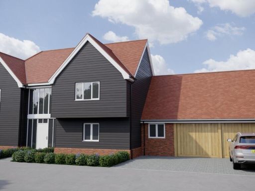 Plot for sale in Church Road, Crowfield, Ipswich, IP6 — £275,000 • 4 bed • 3 bath • 2315 ft²
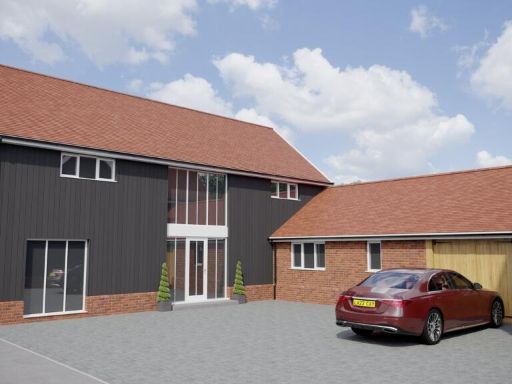 Plot for sale in Church Road, Crowfield, Ipswich, IP6 — £199,995 • 4 bed • 3 bath • 2156 ft²
 Plot for sale in Church Road, Crowfield, Ipswich, IP6 — £199,995 • 4 bed • 3 bath
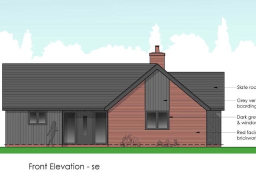 Plot for sale in Bedfield, Nr Framlingham, Suffolk, IP13 — £150,000 • 1 bed • 1 bath • 1270 ft²
Meta
- {
"@context": "https://schema.org",
"@type": "Residence",
"name": "Plot for sale in Church Road, Crowfield, Ipswich, Suffolk,…",
"description": "",
"url": "https://propertypiper.co.uk/property/810f16a5-e2db-4c59-ac04-8ab5f2761b76",
"image": "https://image-a.propertypiper.co.uk/aa1053fb-4861-42e5-9f56-3979a9303782-1024.jpeg",
"address": {
"@type": "PostalAddress",
"streetAddress": "BROOK HALL CHURCH ROAD CROWFIELD IPSWICH",
"postalCode": "IP6 9TG",
"addressLocality": "Mid Suffolk",
"addressRegion": "Central Suffolk and North Ipswich",
"addressCountry": "England"
},
"geo": {
"@type": "GeoCoordinates",
"latitude": 52.1792769,
"longitude": 1.1398376
},
"numberOfRooms": 4,
"numberOfBathroomsTotal": 3,
"floorSize": {
"@type": "QuantitativeValue",
"value": 2315,
"unitCode": "FTK"
},
"offers": {
"@type": "Offer",
"price": 199000,
"priceCurrency": "GBP",
"availability": "https://schema.org/InStock"
},
"additionalProperty": [
{
"@type": "PropertyValue",
"name": "Feature",
"value": "rural"
},
{
"@type": "PropertyValue",
"name": "Feature",
"value": "countryside"
},
{
"@type": "PropertyValue",
"name": "Feature",
"value": "outbuildings"
},
{
"@type": "PropertyValue",
"name": "Feature",
"value": "barn"
},
{
"@type": "PropertyValue",
"name": "Feature",
"value": "farm"
},
{
"@type": "PropertyValue",
"name": "Feature",
"value": "farming"
},
{
"@type": "PropertyValue",
"name": "Feature",
"value": "farmland"
},
{
"@type": "PropertyValue",
"name": "Feature",
"value": "agricultural"
},
{
"@type": "PropertyValue",
"name": "Feature",
"value": "storage"
},
{
"@type": "PropertyValue",
"name": "Feature",
"value": "shed"
},
{
"@type": "PropertyValue",
"name": "Feature",
"value": "workshop"
},
{
"@type": "PropertyValue",
"name": "Feature",
"value": "expansive land"
},
{
"@type": "PropertyValue",
"name": "Feature",
"value": "potential development"
},
{
"@type": "PropertyValue",
"name": "Feature",
"value": "farm"
},
{
"@type": "PropertyValue",
"name": "Feature",
"value": "agricultural"
},
{
"@type": "PropertyValue",
"name": "Feature",
"value": "rural"
},
{
"@type": "PropertyValue",
"name": "Feature",
"value": "barn"
},
{
"@type": "PropertyValue",
"name": "Feature",
"value": "land"
},
{
"@type": "PropertyValue",
"name": "Feature",
"value": "fields"
},
{
"@type": "PropertyValue",
"name": "Feature",
"value": "expansive"
},
{
"@type": "PropertyValue",
"name": "Feature",
"value": "countryside"
},
{
"@type": "PropertyValue",
"name": "Feature",
"value": "garden"
},
{
"@type": "PropertyValue",
"name": "Feature",
"value": "greenhouse"
},
{
"@type": "PropertyValue",
"name": "Feature",
"value": "outbuildings"
}
]
}