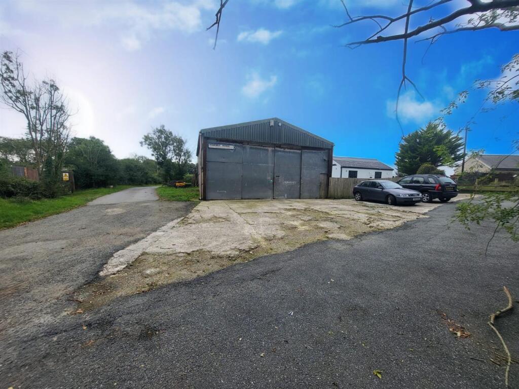
SA62 4DA - Commercial property for sale in Fishguard Road, Haverfordwe…
View on Property Piper
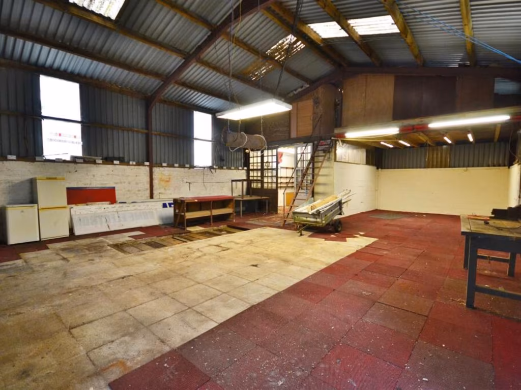
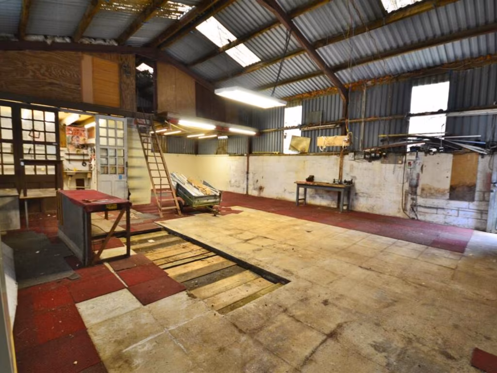
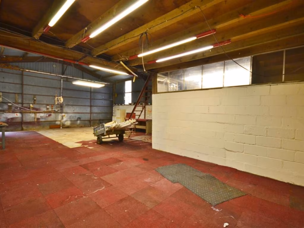
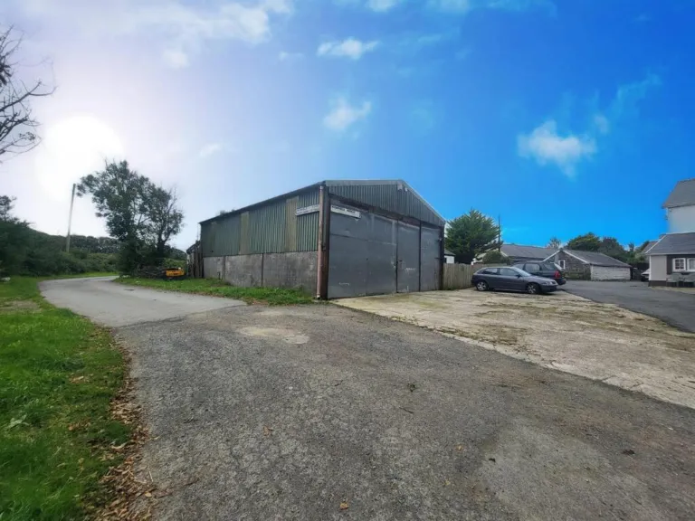
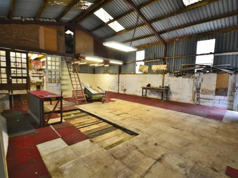
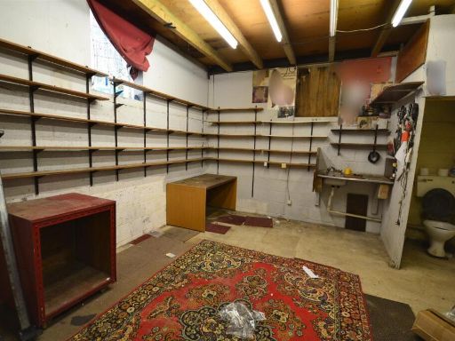
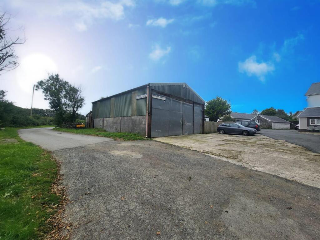
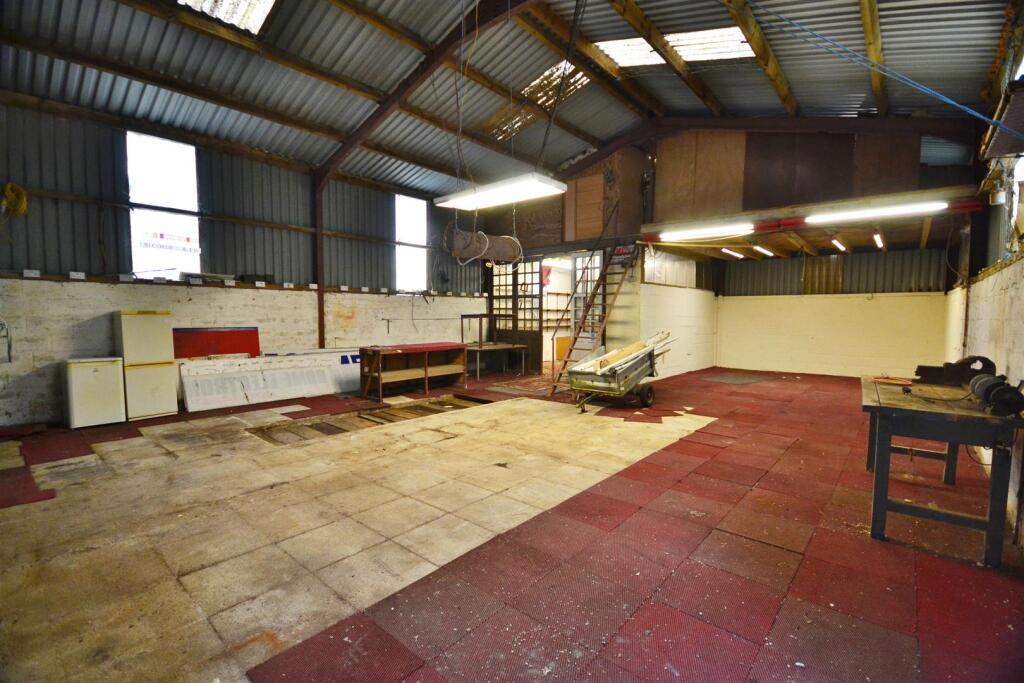
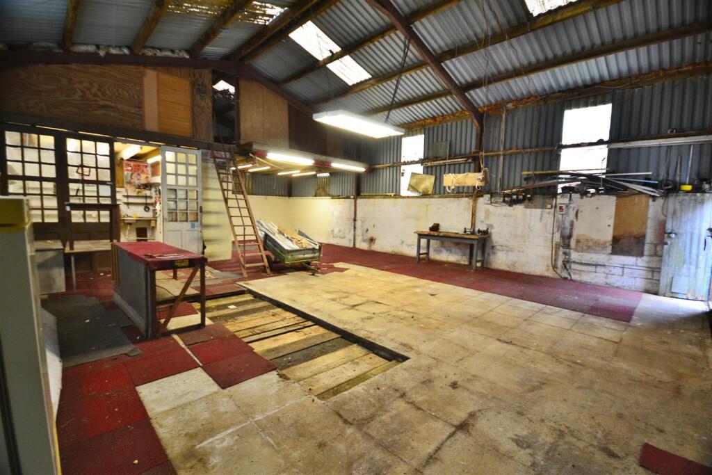
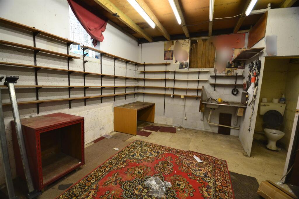
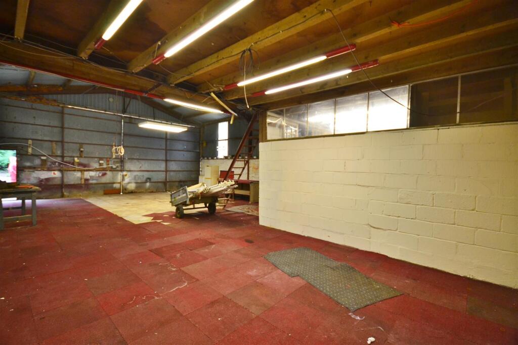
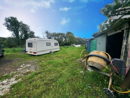
Commercial property for sale in Fishguard Road, Haverfordwest, SA62
Property Details
- Price: £65000
- Bedrooms: 1
- Bathrooms: 1
- Property Type: undefined
- Property SubType: undefined
Image Descriptions
- barn or large shed industrial
- industrial workshop or warehouse space industrial
Textual Property Features
Detected Visual Features
- barn
- industrial style
- large space
- high ceiling
- potential conversion
- investment opportunity
- metal cladding
- concrete base
- industrial building
- workshop space
- warehouse
- vaulted ceiling
- renovation potential
- business premises
Nearest Bars And Restaurants
- Id: 5766414479
- Tags:
- Addr:
- City: Haverfordwest
- Housenumber: Drive Thru
- Postcode: SA61 2PY
- Street: Withybush Retail Park
- Amenity: cafe
- Brand: Costa
- Brand:wikidata: Q608845
- Brand:wikipedia: en:Costa Coffee
- Cuisine: coffee_shop
- Drive_through: yes
- Name: Costa Drive Thru
- Opening_hours: Mo 07:00-20:00; Tu 07:00-20:00; We 07:00-20:00; Th 07:00-20:00; Fr 07:00-18:00; Sa 00:00-24:00; Su 08:00-18:00
- Outdoor_seating: no
- Takeaway: only
- Website: https://www.costa.co.uk/locations/store-locator/map?latitude=51.8116&longitude=-4.963920000000002
- TagsNormalized:
- cafe
- costa
- coffee
- drive through
- takeaway
- Lat: 51.8116168
- Lon: -4.9638428
- FullGeoHash: gchqz012w16s
- PartitionGeoHash: gchq
- Images:
- FoodStandards: null
- Distance: 3513
,- Id: 684566288
- Tags:
- Amenity: pub
- Name: The Rising Sun
- Wikidata: Q80856274
- TagsNormalized:
- Lat: 51.8142691
- Lon: -4.9998395
- FullGeoHash: gchqy0rpzrc6
- PartitionGeoHash: gchq
- Images:
- FoodStandards: null
- Distance: 3489.4
,- Id: 9373565153
- Tags:
- Addr:
- City: Haverfordwest
- Housenumber: Withybush Hospital
- Postcode: SA61 2PZ
- Street: Fishguard Road
- Amenity: cafe
- Brand: Costa
- Brand:wikidata: Q608845
- Brand:wikipedia: en:Costa Coffee
- Cuisine: coffee_shop
- Name: Costa
- Opening_hours: Mo,Tu 10:00-14:00; We,Th 08:00-17:00; Fr 08:00-15:00; Sa,Su 00:00-24:00
- Outdoor_seating: no
- Takeaway: yes
- Website: https://www.costa.co.uk/locations/store-locator/map?latitude=51.812700000000035&longitude=-4.965239999999994
- TagsNormalized:
- Lat: 51.8128223
- Lon: -4.9647044
- FullGeoHash: gchqz00zd40h
- PartitionGeoHash: gchq
- Images:
- FoodStandards: null
- Distance: 3368.4
,- Id: 560474335
- Tags:
- Amenity: restaurant
- Building: yes
- Name: The Lost Coins
- Operator: Marsdons
- Wikidata: Q80582178
- TagsNormalized:
- Lat: 51.817271
- Lon: -4.9630154
- FullGeoHash: gchqz1413r7m
- PartitionGeoHash: gchq
- Images:
- FoodStandards: null
- Distance: 2926.5
,- Id: 1195206441
- Tags:
- Amenity: pub
- Name: The Corner Piece
- Wikidata: Q80582188
- TagsNormalized:
- Lat: 51.8577552
- Lon: -4.9677532
- FullGeoHash: gchrnbqt6fnx
- PartitionGeoHash: gchr
- Images:
- FoodStandards: null
- Distance: 1835.5
}
Nearest General Shops
- Id: 9373565151
- Tags:
- Addr:
- City: Haverfordwest
- Housename: Springfield Retail Park
- Postcode: SA61 2AT
- Street: Fishguard Road
- Unit: Unit F
- Brand: currys
- Brand:wikidata: Q3246464
- Brand:wikipedia: en:Currys
- Contact:
- Website: https://www.currys.co.uk/store-finder/haverfordwest-1809.html
- Name: Currys
- Operator: Currys Retail Limited
- Shop: electronics
- TagsNormalized:
- Lat: 51.8161805
- Lon: -4.9626089
- FullGeoHash: gchqz0f74u4s
- PartitionGeoHash: gchq
- Images:
- FoodStandards: null
- Distance: 3050.3
,- Id: 9373565152
- Tags:
- Addr:
- City: Haverfordwest
- Housenumber: Unit D, Springfield Retail Par
- Postcode: SA61 2AT
- Street: Fishguard Road
- Brand: Pets at Home
- Brand:wikidata: Q7179258
- Brand:wikipedia: en:Pets at Home
- Name: Pets at Home
- Phone: +44 345 266 0141
- Shop: pet
- Website: https://community.petsathome.com/store/haverfordwest/
- TagsNormalized:
- Lat: 51.8161257
- Lon: -4.9632907
- FullGeoHash: gchqz0cffcyj
- PartitionGeoHash: gchq
- Images:
- FoodStandards: null
- Distance: 3041.6
,- Id: 205217498
- Tags:
- Building: shop
- Name: CEM Day
- Shop: car
- TagsNormalized:
- Lat: 51.8187511
- Lon: -4.9626968
- FullGeoHash: gchqz1660g34
- PartitionGeoHash: gchq
- Images:
- FoodStandards: null
- Distance: 2778.6
}
Nearest Grocery shops
- Id: 9934193792
- Tags:
- Addr:
- City: Haverfordwest
- Housenumber: 6-10
- Postcode: SA61 2LX
- Street: Picton Place
- Alt_name: Iceland Haverfordwest
- Brand: Iceland
- Brand:wikidata: Q721810
- Brand:wikipedia: en:Iceland (supermarket)
- Fhrs:
- Name: Iceland
- Shop: frozen_food
- Website: https://www.iceland.co.uk/store-finder/store?StoreID=123&StoreName=HAVERFORDWEST
- TagsNormalized:
- iceland
- frozen food
- food
- shop
- Lat: 51.8026749
- Lon: -4.9666116
- FullGeoHash: gchqwyrkmw9b
- PartitionGeoHash: gchq
- Images:
- FoodStandards:
- Id: 856551
- FHRSID: 856551
- LocalAuthorityBusinessID: 231267
- BusinessName: Iceland Frozen Foods Plc
- BusinessType: Retailers - supermarkets/hypermarkets
- BusinessTypeID: 7840
- AddressLine1: 8 - 10 Picton Place
- AddressLine2: null
- AddressLine3: Haverfordwest
- AddressLine4: Pembrokeshire
- PostCode: SA61 2LX
- RatingValue: 5
- RatingKey: fhrs_5_en-GB
- RatingDate: 2011-10-18
- LocalAuthorityCode: 565
- LocalAuthorityName: Pembrokeshire
- LocalAuthorityWebSite: http://www.pembrokeshire.gov.uk
- LocalAuthorityEmailAddress: foodratings@pembrokeshire.gov.uk
- Scores:
- Hygiene: 0
- Structural: 5
- ConfidenceInManagement: 0
- NewRatingPending: false
- Geocode:
- Longitude: -4.96647700000000
- Latitude: 51.80277600000000
- Distance: 4448.8
,- Id: 308707561
- Tags:
- Addr:
- City: Haverfordwest
- Housenumber: 15
- Postcode: SA61 2LJ
- Street: Riverside Quay Shopping Centre
- Brand: Holland & Barrett
- Brand:wikidata: Q5880870
- Brand:wikipedia: en:Holland & Barrett
- Building: yes
- Name: Holland & Barrett
- Shop: health_food
- TagsNormalized:
- holland & barrett
- health
- health food
- food
- shop
- Lat: 51.8033801
- Lon: -4.9676193
- FullGeoHash: gchqwyw8w1fx
- PartitionGeoHash: gchq
- Images:
- FoodStandards: null
- Distance: 4361
,- Id: 2259026604
- Tags:
- TagsNormalized:
- Lat: 51.8084518
- Lon: -4.9644673
- FullGeoHash: gchqxp2ype2u
- PartitionGeoHash: gchq
- Images:
- FoodStandards: null
- Distance: 3845.1
}
Nearest Religious buildings
- Id: 1387155102
- Tags:
- Amenity: place_of_worship
- Religion: christian
- TagsNormalized:
- place of worship
- christian
- church
- Lat: 51.8678829
- Lon: -4.9411196
- FullGeoHash: gchrpd3brd4j
- PartitionGeoHash: gchr
- Images:
- FoodStandards: null
- Distance: 3758.1
,- Id: 631329342
- Tags:
- Amenity: place_of_worship
- Building: yes
- Name: Treffgarne Church
- Religion: christian
- TagsNormalized:
- place of worship
- church
- christian
- Lat: 51.8743025
- Lon: -4.9694096
- FullGeoHash: gchrngmmsqge
- PartitionGeoHash: gchr
- Images:
- FoodStandards: null
- Distance: 3604.7
,- Id: 918166717
- Tags:
- Amenity: place_of_worship
- Building: church
- Name: St Michael's Church
- TagsNormalized:
- Lat: 51.8462911
- Lon: -4.9626893
- FullGeoHash: gchqzn668cnt
- PartitionGeoHash: gchq
- Images:
- FoodStandards: null
- Distance: 1063.6
}
Nearest Medical buildings
- Id: 561541539
- Tags:
- Amenity: pharmacy
- Building: yes
- Drive_through: no
- Healthcare: pharmacy
- Name: Noots Pharmacy
- TagsNormalized:
- Lat: 51.7981946
- Lon: -4.9705706
- FullGeoHash: gchqwvsd373f
- PartitionGeoHash: gchq
- Images:
- FoodStandards: null
- Distance: 4910.8
,- Id: 1139349724
- Tags:
- Amenity: pharmacy
- Brand: Lloyds Pharmacy
- Brand:wikidata: Q6662870
- Healthcare: pharmacy
- Name: Lloyds Pharmacy
- Operator: Lloyd's Pharmacy
- TagsNormalized:
- pharmacy
- lloyds pharmacy
- health
- healthcare
- Lat: 51.7987098
- Lon: -4.9696776
- FullGeoHash: gchqwvtjq57g
- PartitionGeoHash: gchq
- Images:
- FoodStandards: null
- Distance: 4859.5
,- Id: 1150536095
- Tags:
- Amenity: dentist
- Building: yes
- Healthcare: dentist
- TagsNormalized:
- Lat: 51.7985977
- Lon: -4.9781574
- FullGeoHash: gchqwtxh8w2y
- PartitionGeoHash: gchq
- Images:
- FoodStandards: null
- Distance: 4849.1
,- Id: 24826184
- Tags:
- Addr:
- Postcode: SA61 2PZ
- Street: Fishguard Road
- Amenity: hospital
- Fhrs:
- Name: Withybush Hospital
- Name:cy: Ysbyty Cyffredinol Llwynhelyg
- Source:
- Wheelchair: yes
- Wikidata: Q8028300
- Wikipedia: en:Withybush General Hospital
- TagsNormalized:
- Lat: 51.8131241
- Lon: -4.9646942
- FullGeoHash: gchqz02c64rs
- PartitionGeoHash: gchq
- Images:
- FoodStandards:
- Id: 856282
- FHRSID: 856282
- LocalAuthorityBusinessID: 230963
- BusinessName: Withybush Hospital
- BusinessType: Hospitals/Childcare/Caring Premises
- BusinessTypeID: 5
- AddressLine1: Withybush General Hospital Fishguard Road
- AddressLine2: null
- AddressLine3: Haverfordwest
- AddressLine4: Pembrokeshire
- PostCode: SA61 2PZ
- RatingValue: 5
- RatingKey: fhrs_5_en-GB
- RatingDate: 2020-01-21
- LocalAuthorityCode: 565
- LocalAuthorityName: Pembrokeshire
- LocalAuthorityWebSite: http://www.pembrokeshire.gov.uk
- LocalAuthorityEmailAddress: foodratings@pembrokeshire.gov.uk
- Scores:
- Hygiene: 0
- Structural: 0
- ConfidenceInManagement: 5
- NewRatingPending: false
- Geocode:
- Longitude: -4.96508500000000
- Latitude: 51.81272200000000
- Distance: 3336.1
}
Nearest Leisure Facilities
- Id: 716914764
- Tags:
- Leisure: pitch
- Sport: tennis
- TagsNormalized:
- Lat: 51.8521519
- Lon: -5.0129994
- FullGeoHash: gchqvzmsstsw
- PartitionGeoHash: gchq
- Images:
- FoodStandards: null
- Distance: 2729.2
,- Id: 758831036
- Tags:
- Leisure: pitch
- Sport: soccer
- Surface: grass
- TagsNormalized:
- Lat: 51.847063
- Lon: -5.0132016
- FullGeoHash: gchqvymrpcjc
- PartitionGeoHash: gchq
- Images:
- FoodStandards: null
- Distance: 2566.4
,- Id: 104449056
- Tags:
- Leisure: sports_centre
- Sport: soccer
- TagsNormalized:
- sports
- sports centre
- leisure
- soccer
- Lat: 51.8464152
- Lon: -5.0131963
- FullGeoHash: gchqvyme203c
- PartitionGeoHash: gchq
- Images:
- FoodStandards: null
- Distance: 2551.8
,- Id: 758831037
- Tags:
- Leisure: pitch
- Sport: soccer
- Surface: grass
- TagsNormalized:
- Lat: 51.8463091
- Lon: -5.0132139
- FullGeoHash: gchqvym6xssb
- PartitionGeoHash: gchq
- Images:
- FoodStandards: null
- Distance: 2550.9
,- Id: 758831038
- Tags:
- Leisure: pitch
- Sport: soccer
- Surface: grass
- TagsNormalized:
- Lat: 51.8457358
- Lon: -5.0131026
- FullGeoHash: gchqvyjx61xu
- PartitionGeoHash: gchq
- Images:
- FoodStandards: null
- Distance: 2532.7
}
Nearest Tourist attractions
- Id: 365150678
- Tags:
- Name: Museum Store and Viewing Barn
- Source: Bing, map of park grounds
- Tourism: museum
- TagsNormalized:
- Lat: 51.8570161
- Lon: -4.919873
- FullGeoHash: gchx0033n8ky
- PartitionGeoHash: gchx
- Images:
- FoodStandards: null
- Distance: 4235.8
,- Id: 684566290
- Tags:
- TagsNormalized:
- Lat: 51.8146843
- Lon: -5.0010352
- FullGeoHash: gchqy0w67mjz
- PartitionGeoHash: gchq
- Images:
- FoodStandards: null
- Distance: 3487.1
,- Id: 205182048
- Tags:
- Alt_name: The Dingle
- Name: Crundale House
- Tourism: guest_house
- TagsNormalized:
- Lat: 51.8203418
- Lon: -4.9424228
- FullGeoHash: gchqz99535y7
- PartitionGeoHash: gchq
- Images:
- FoodStandards: null
- Distance: 3383.5
}
Nearest Train stations
- Id: 19840190
- Tags:
- Name: Milford Haven
- Name:cy: Aberdaugleddau
- Name:en: Milford Haven
- Naptan:
- Network: National Rail
- Operator: Trafnidiaeth Cymru
- Operator:cy: Trafnidiaeth Cymru
- Operator:en: Transport for Wales
- Public_transport: station
- Railway: station
- Ref:
- Wikidata: Q3400252
- Wikipedia: en:Milford Haven railway station
- TagsNormalized:
- Lat: 51.7157559
- Lon: -5.0414117
- FullGeoHash: gchqjq8fnedu
- PartitionGeoHash: gchq
- Images:
- FoodStandards: null
- Distance: 14748
,- Id: 1590432668
- Tags:
- Name: Main Entrance Station
- Public_transport: station
- Railway: station
- Usage: tourism
- TagsNormalized:
- Lat: 51.7775924
- Lon: -4.8001387
- FullGeoHash: gchwdcbdkdv1
- PartitionGeoHash: gchw
- Images:
- FoodStandards: null
- Distance: 14103.8
,- Id: 858361120
- Tags:
- Name: Oakwood Park Station
- Public_transport: station
- Railway: station
- Usage: tourism
- TagsNormalized:
- Lat: 51.7789542
- Lon: -4.8028585
- FullGeoHash: gchwddndm29h
- PartitionGeoHash: gchw
- Images:
- FoodStandards: null
- Distance: 13865.6
,- Id: 19840233
- Tags:
- Name: Johnston
- Naptan:
- Network: National Rail
- Public_transport: station
- Railway: station
- Ref:
- Request_stop: yes
- Train: yes
- Wikidata: Q1812881
- Wikipedia: en:Johnston railway station
- TagsNormalized:
- Lat: 51.7564283
- Lon: -4.9968493
- FullGeoHash: gchqqmcrhcx0
- PartitionGeoHash: gchq
- Images:
- FoodStandards: null
- Distance: 9637.3
,- Id: 19840285
- Tags:
- Name: Haverfordwest
- Name:cy: Hwlffordd
- Naptan:
- Network: National Rail
- Operator: Trafnidiaeth Cymru
- Operator:cy: Trafnidiaeth Cymru
- Operator:en: Transport for Wales
- Public_transport: station
- Railway: station
- Ref:
- Wikidata: Q1931357
- Wikipedia: en:Haverfordwest railway station
- TagsNormalized:
- Lat: 51.8026795
- Lon: -4.960232
- FullGeoHash: gchqxnkh6pqg
- PartitionGeoHash: gchq
- Images:
- FoodStandards: null
- Distance: 4537.3
}
Nearest Bus stations and stops
- Id: 5997795334
- Tags:
- Bus: yes
- Highway: bus_stop
- Public_transport: platform
- TagsNormalized:
- Lat: 51.8107513
- Lon: -4.9639769
- FullGeoHash: gchqxpc7dbnd
- PartitionGeoHash: gchq
- Images:
- FoodStandards: null
- Distance: 3604
,- Id: 5997795331
- Tags:
- Bus: yes
- Highway: bus_stop
- Public_transport: platform
- TagsNormalized:
- Lat: 51.8124924
- Lon: -4.9628089
- FullGeoHash: gchqz04jwhtk
- PartitionGeoHash: gchq
- Images:
- FoodStandards: null
- Distance: 3437.9
,- Id: 5997795332
- Tags:
- Bus: yes
- Highway: bus_stop
- Public_transport: platform
- TagsNormalized:
- Lat: 51.8127471
- Lon: -4.9635819
- FullGeoHash: gchqz01xhhj5
- PartitionGeoHash: gchq
- Images:
- FoodStandards: null
- Distance: 3396.2
,- Id: 9769129626
- Tags:
- Bus: yes
- Highway: bus_stop
- Public_transport: platform
- TagsNormalized:
- Lat: 51.8704083
- Lon: -4.9645208
- FullGeoHash: gchrp48zn2bv
- PartitionGeoHash: gchr
- Images:
- FoodStandards: null
- Distance: 3246.2
,- Id: 9769129625
- Tags:
- Bus: yes
- Highway: bus_stop
- Public_transport: platform
- TagsNormalized:
- Lat: 51.8690517
- Lon: -4.9652943
- FullGeoHash: gchrp42rhk01
- PartitionGeoHash: gchr
- Images:
- FoodStandards: null
- Distance: 3086.8
}
Nearest Hotels
- Id: 321817678
- Tags:
- TagsNormalized:
- Lat: 51.8015206
- Lon: -4.973843
- FullGeoHash: gchqwy4jtp3f
- PartitionGeoHash: gchq
- Images:
- FoodStandards: null
- Distance: 4527.2
,- Id: 123021216
- Tags:
- Addr:
- Postcode: SA61 2NB
- Street: Salutation Square
- Building: hotel
- Fax: +44 (0)1437 762504
- Fhrs:
- Internet_access: wlan
- Internet_access:fee: no
- Name: County Hotel
- Phone: +44 1437 762144
- Source:
- Tourism: hotel
- Website: https://countyhotelhaverfordwest.co.uk/
- Wikidata: Q29490505
- TagsNormalized:
- Lat: 51.8028393
- Lon: -4.9661368
- FullGeoHash: gchqwyrv2thj
- PartitionGeoHash: gchq
- Images:
- FoodStandards: null
- Distance: 4436
,- Id: 4231510694
- Tags:
- Addr:
- Postcode: SA62 4BP
- Street: Fishguard Road
- Brand: Premier Inn
- Brand:wikidata: Q2108626
- Brand:wikipedia: en:Premier Inn
- Fhrs:
- Name: Premier Inn
- Operator: Premier Inns
- Source:
- Tourism: hotel
- TagsNormalized:
- Lat: 51.8176056
- Lon: -4.9639347
- FullGeoHash: gchqz1177vy1
- PartitionGeoHash: gchq
- Images:
- FoodStandards: null
- Distance: 2871.3
}
Tags
- barn
- industrial style
- large space
- high ceiling
- potential conversion
- investment opportunity
- metal cladding
- concrete base
- industrial building
- workshop space
- warehouse
- vaulted ceiling
- renovation potential
- business premises
Local Market Stats
- Average Price/sqft: £231
- Avg Income: £37200
- Social Housing: 7%
- Planning Success Rate: 89%
AirBnB Data
- 1km average: £51/night
- Listings in 1km: 1
Similar Properties
 Commercial property for sale in Fishguard Road, Haverfordwest, SA62 — £99,000 • 1 bed • 1 bath
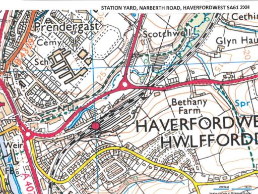 Light industrial facility for sale in Station Yard, Narberth Road, Haverfordwest SA61 2XH, SA61 — £395,000 • 1 bed • 1 bath
 Property for sale in Plot 10 Celtic Link Industrial Park, Scleddau, Fishguard, SA65 — £130,000 • 1 bed • 1 bath • 15877 ft²
 Showroom for sale in Motec Garage, 28 Shipmans Lane, Haverfordwest, Pembrokeshire, South West Wales, SA61 — £595,000 • 1 bed • 1 bath • 23087 ft²
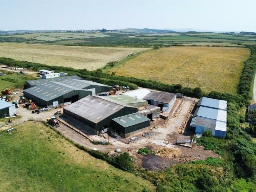 Land for sale in Nolton Haven, Haverfordwest, SA62 — £600,000 • 1 bed • 1 bath • 3000 ft²
 4 bedroom detached house for sale in Willowcot, Talbenny, Haverfordwest, SA62 — £675,000 • 4 bed • 2 bath • 8757 ft²
Meta
- {
"@context": "https://schema.org",
"@type": "Residence",
"name": "Commercial property for sale in Fishguard Road, Haverfordwe…",
"description": "",
"url": "https://propertypiper.co.uk/property/7e0506d0-69f9-465a-8201-62596549d44c",
"image": "https://image-a.propertypiper.co.uk/154bd850-7162-4f4a-a109-f16c61ae82e6-1024.jpeg",
"address": {
"@type": "PostalAddress",
"streetAddress": "HOOK FARMHOUSE FISHGUARD ROAD HAVERFORDWEST",
"postalCode": "SA62 4DA",
"addressLocality": "Pembrokeshire",
"addressRegion": "Preseli Pembrokeshire",
"addressCountry": "Wales"
},
"geo": {
"@type": "GeoCoordinates",
"latitude": 51.842197,
"longitude": -4.9766828
},
"numberOfRooms": 1,
"numberOfBathroomsTotal": 1,
"floorSize": {
"@type": "QuantitativeValue",
"value": 1305,
"unitCode": "FTK"
},
"offers": {
"@type": "Offer",
"price": 65000,
"priceCurrency": "GBP",
"availability": "https://schema.org/InStock"
},
"additionalProperty": [
{
"@type": "PropertyValue",
"name": "Feature",
"value": "barn"
},
{
"@type": "PropertyValue",
"name": "Feature",
"value": "industrial style"
},
{
"@type": "PropertyValue",
"name": "Feature",
"value": "large space"
},
{
"@type": "PropertyValue",
"name": "Feature",
"value": "high ceiling"
},
{
"@type": "PropertyValue",
"name": "Feature",
"value": "potential conversion"
},
{
"@type": "PropertyValue",
"name": "Feature",
"value": "investment opportunity"
},
{
"@type": "PropertyValue",
"name": "Feature",
"value": "metal cladding"
},
{
"@type": "PropertyValue",
"name": "Feature",
"value": "concrete base"
},
{
"@type": "PropertyValue",
"name": "Feature",
"value": "industrial building"
},
{
"@type": "PropertyValue",
"name": "Feature",
"value": "workshop space"
},
{
"@type": "PropertyValue",
"name": "Feature",
"value": "warehouse"
},
{
"@type": "PropertyValue",
"name": "Feature",
"value": "vaulted ceiling"
},
{
"@type": "PropertyValue",
"name": "Feature",
"value": "renovation potential"
},
{
"@type": "PropertyValue",
"name": "Feature",
"value": "business premises"
}
]
}