SE20 7BL - 3 bedroom terraced house for sale in Kingswood Road, Penge,…
View on Property Piper
3 bedroom terraced house for sale in Kingswood Road, Penge, London, SE20
Property Details
- Price: £850000
- Bedrooms: 3
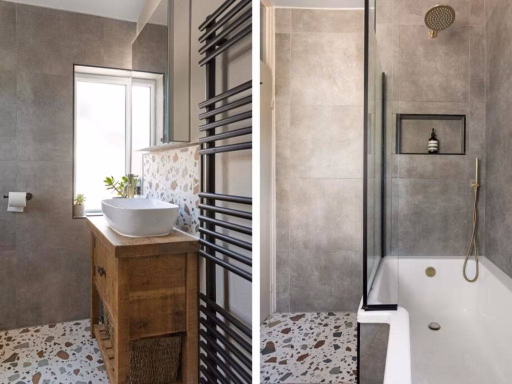
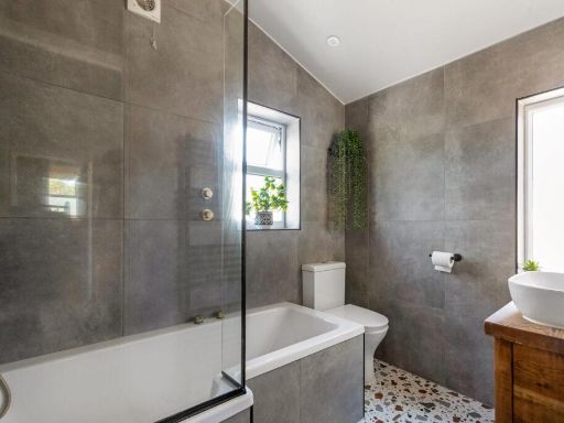
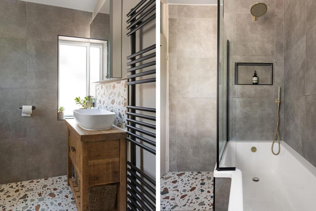
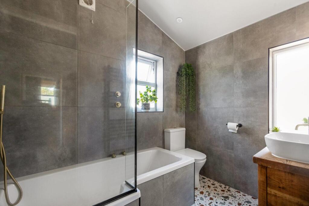
- Bathrooms: 1
- Property Type: undefined
- Property SubType: undefined
Brochure Descriptions
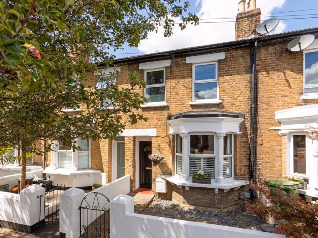
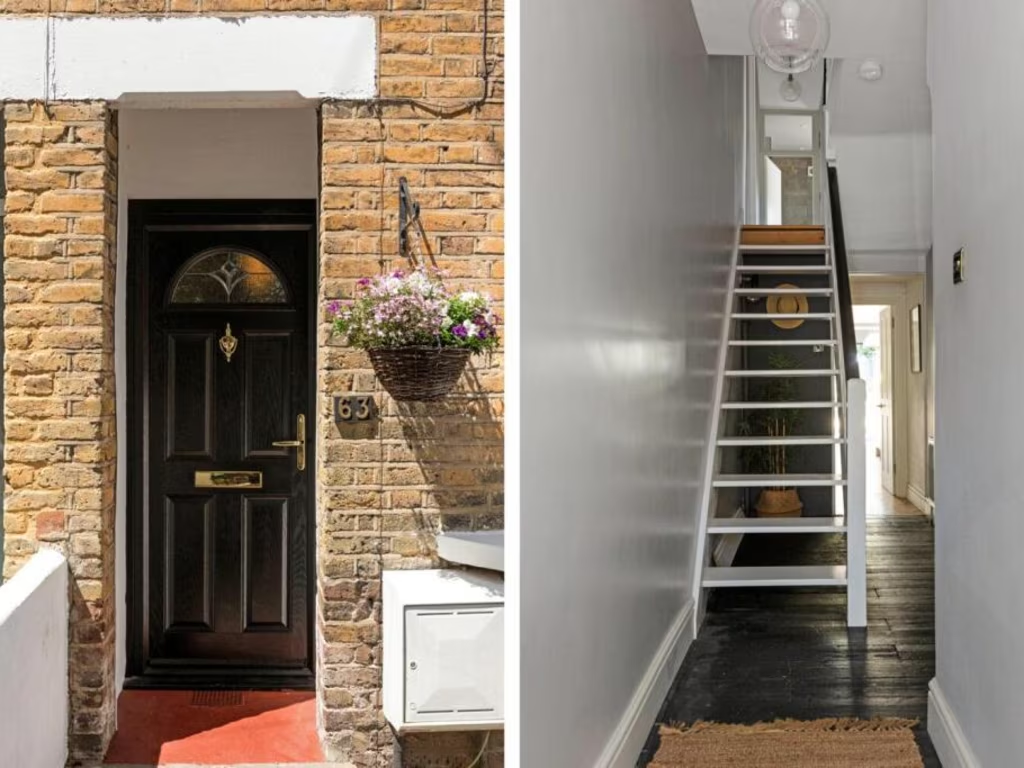
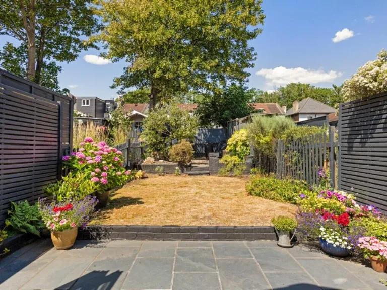
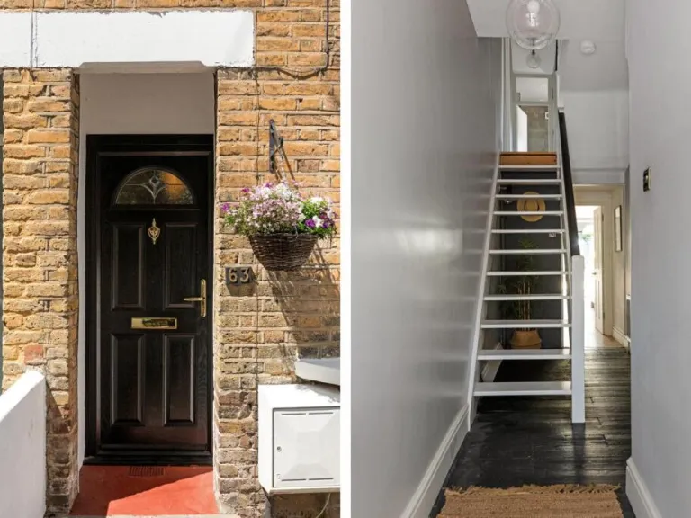
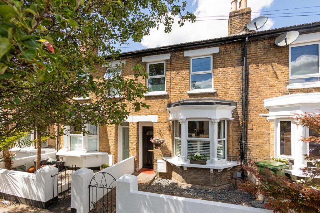
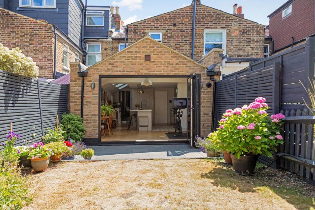
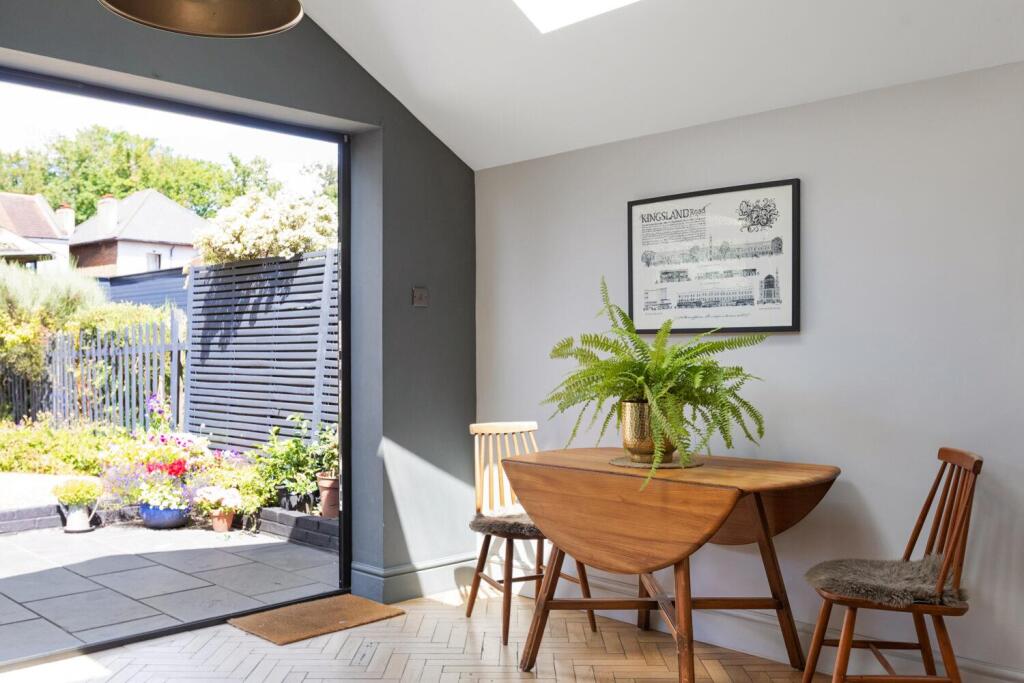
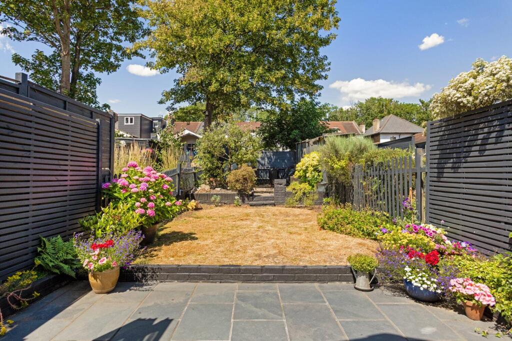
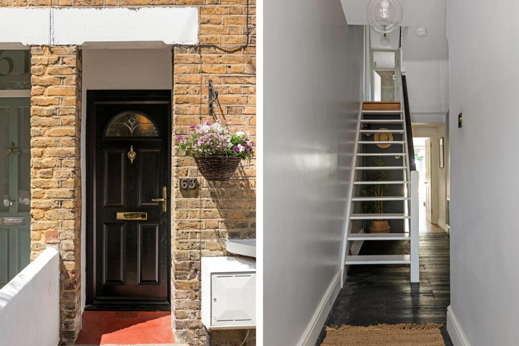
- Mid-terraced, two-storey Victorian brick house with a projecting bay window to the front. The property presents a traditional façade with painted decorative lintels and a small walled front courtyard/garden area with gated access from the pavement. The frontage and mature street trees provide attractive kerb appeal. Internally (not pictured) the external appearance suggests period proportions and potential for good natural light to the front reception room via the bay window. Plot and garden size at the front are small; overall property footprint appears typical for a terraced house in this suburban location (average plot size). Suitable for buyers seeking a period terrace with scope for internal updating or retention of original features.
Image Descriptions
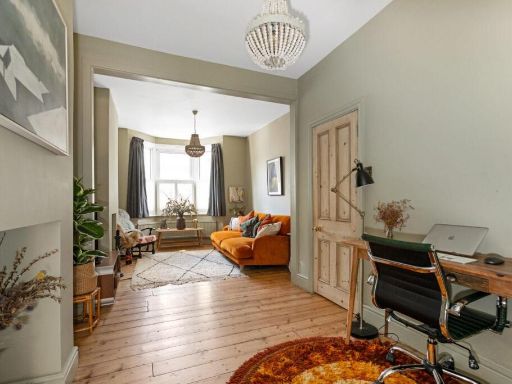
- Victorian terrace house Victorian
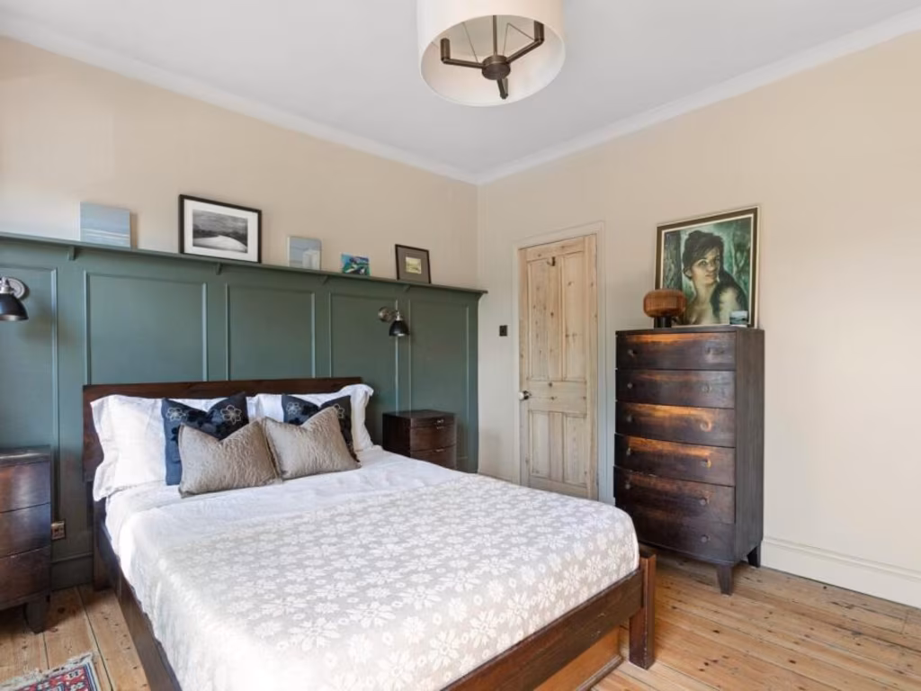
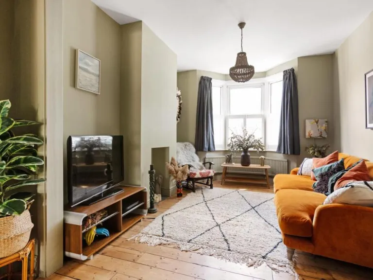
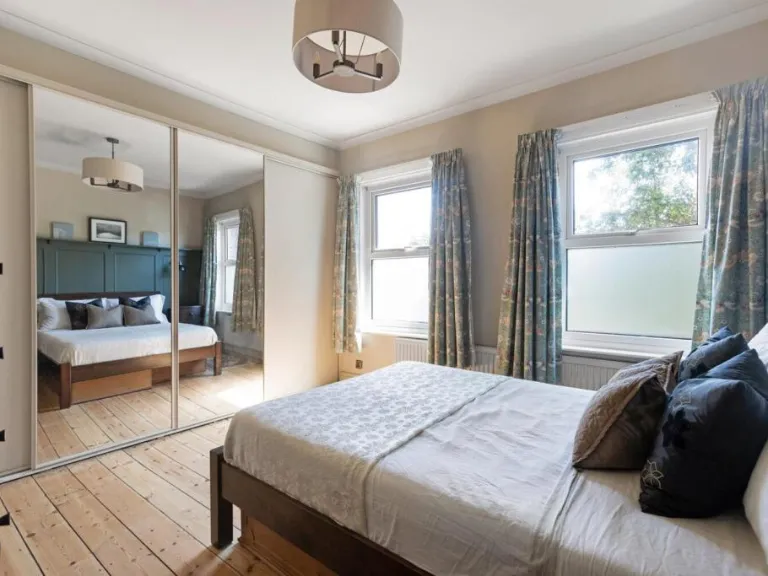
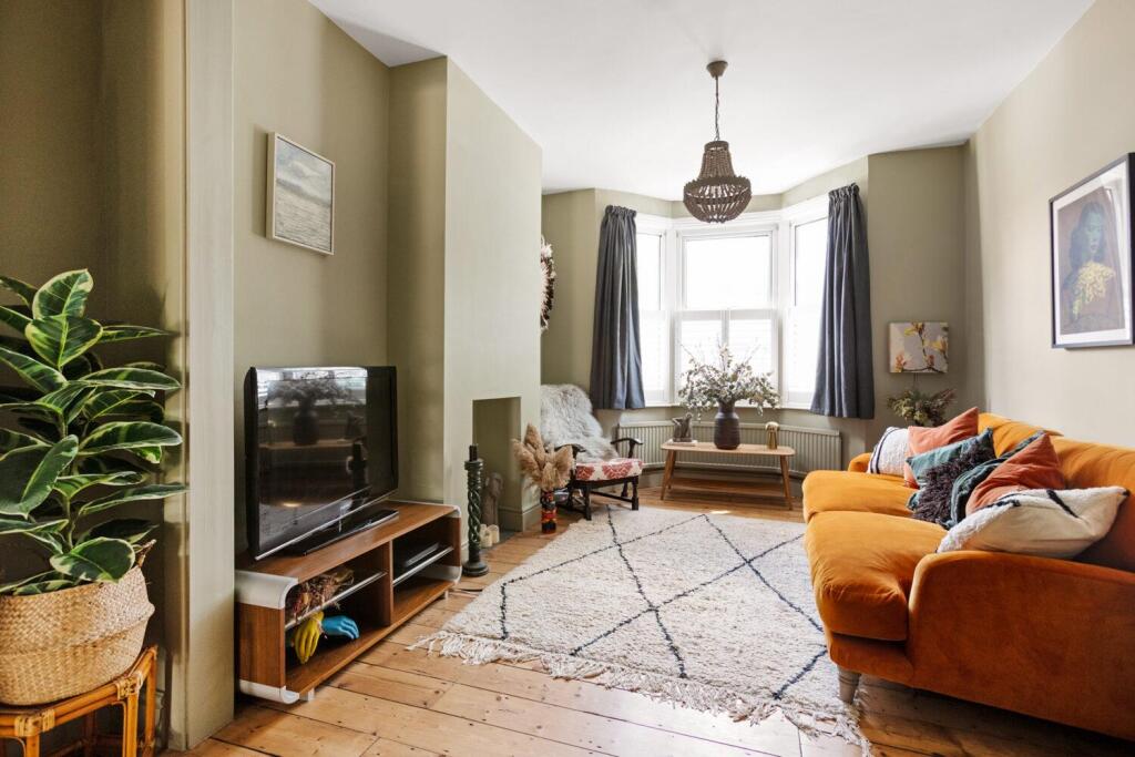
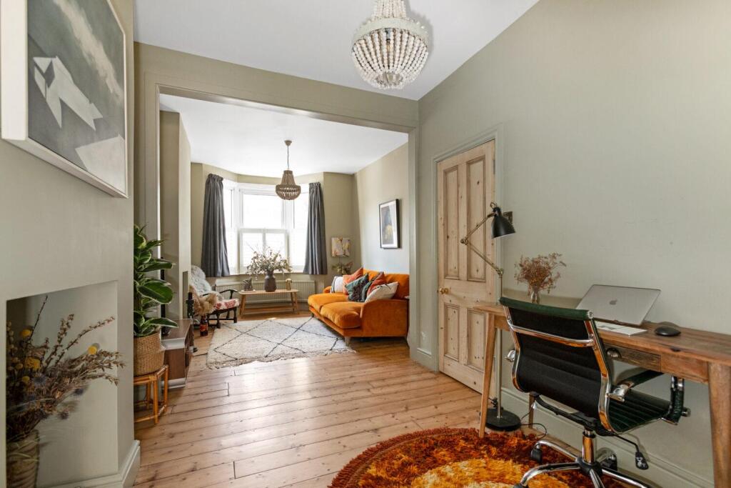
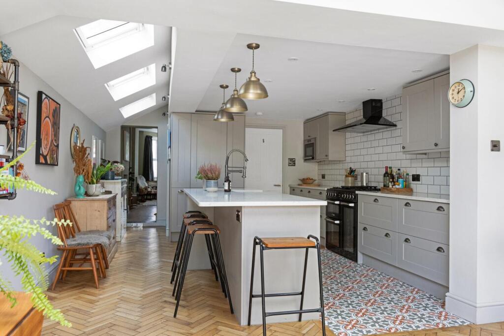
- living room Victorian
Floorplan Description
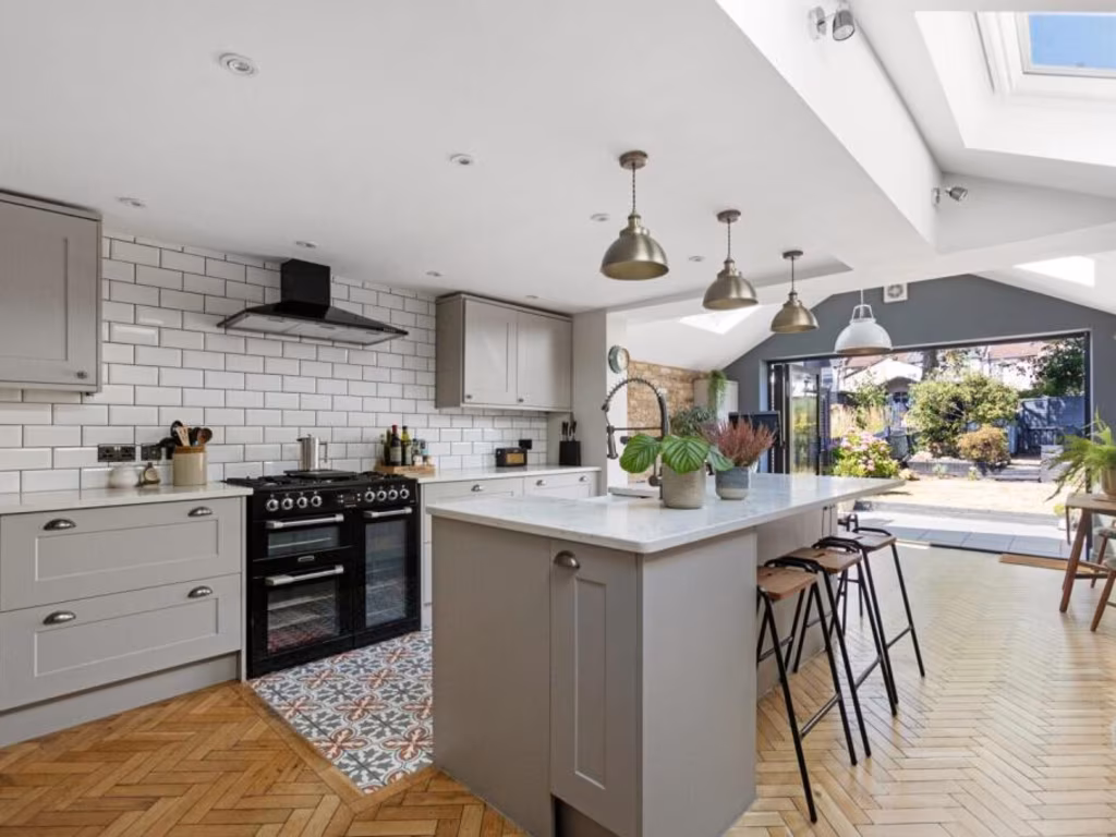
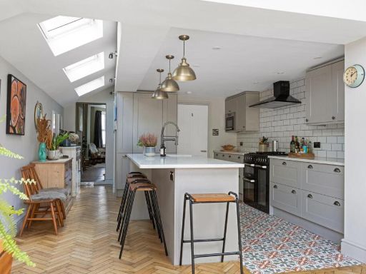
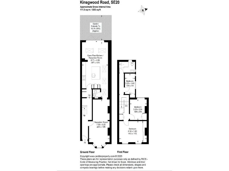
- Terraced house with open-plan kitchen/reception and three first-floor bedrooms
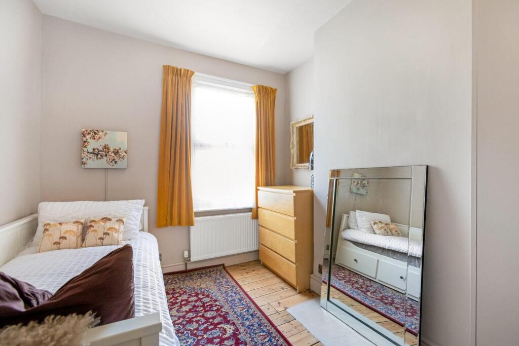
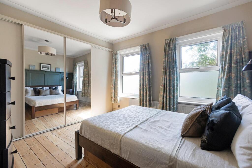
Rooms
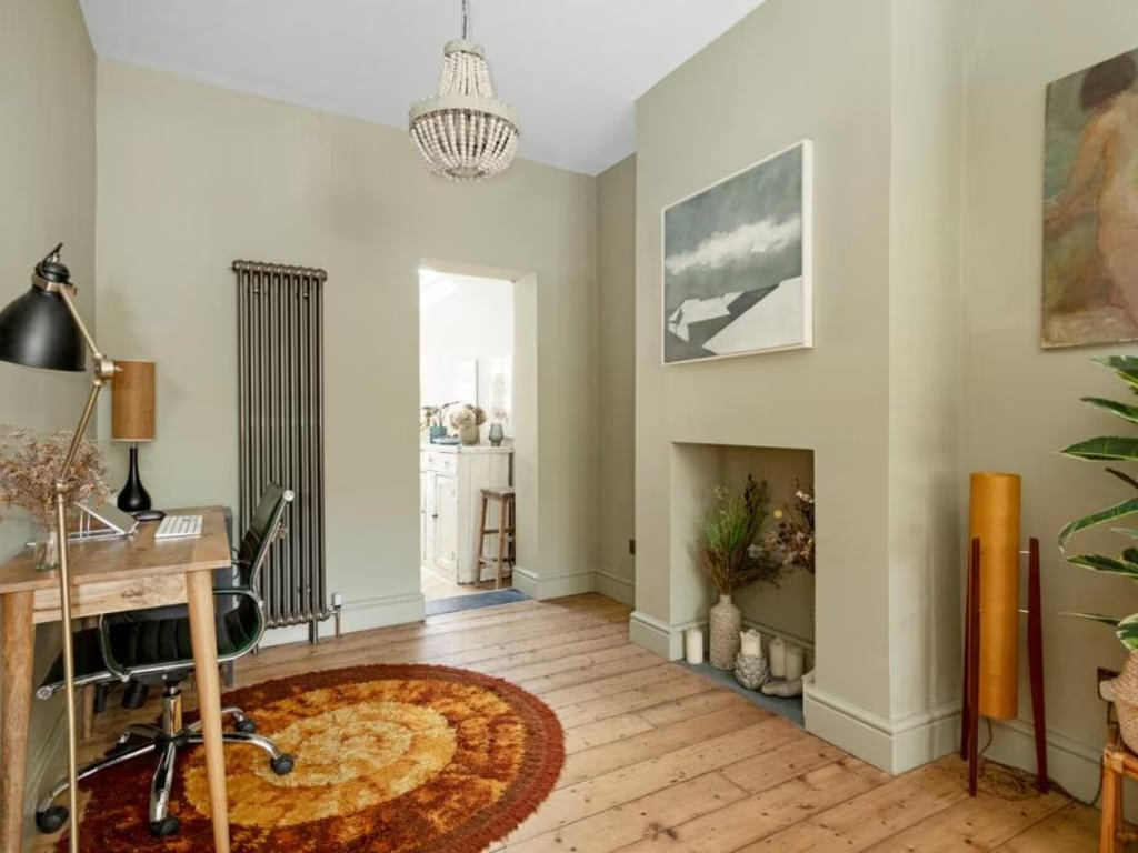
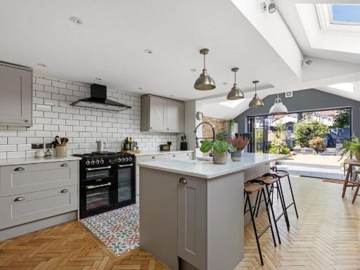
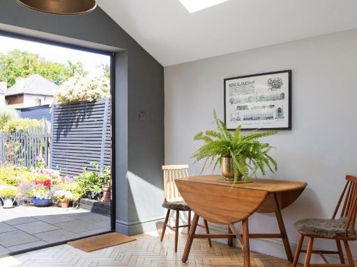
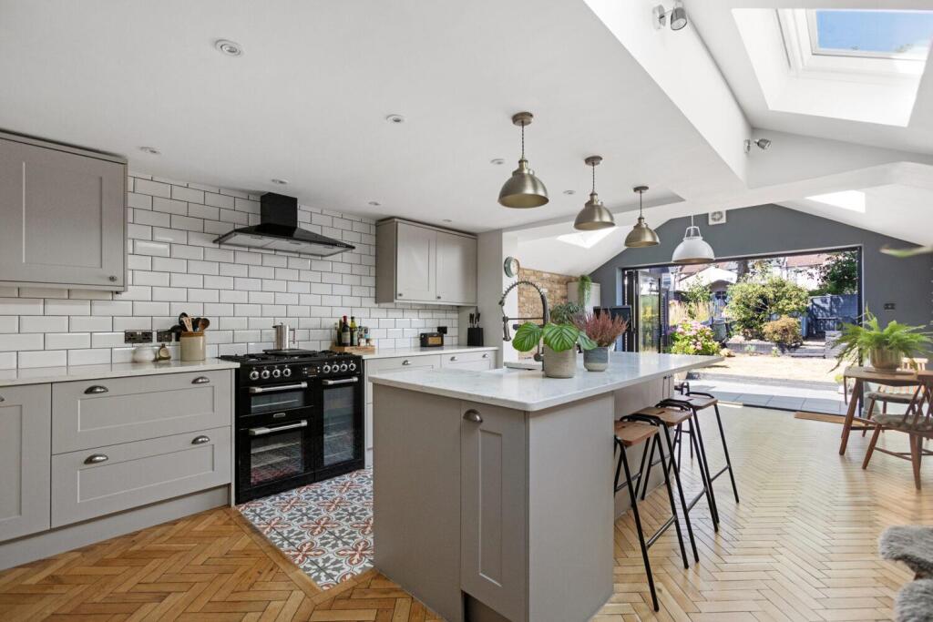
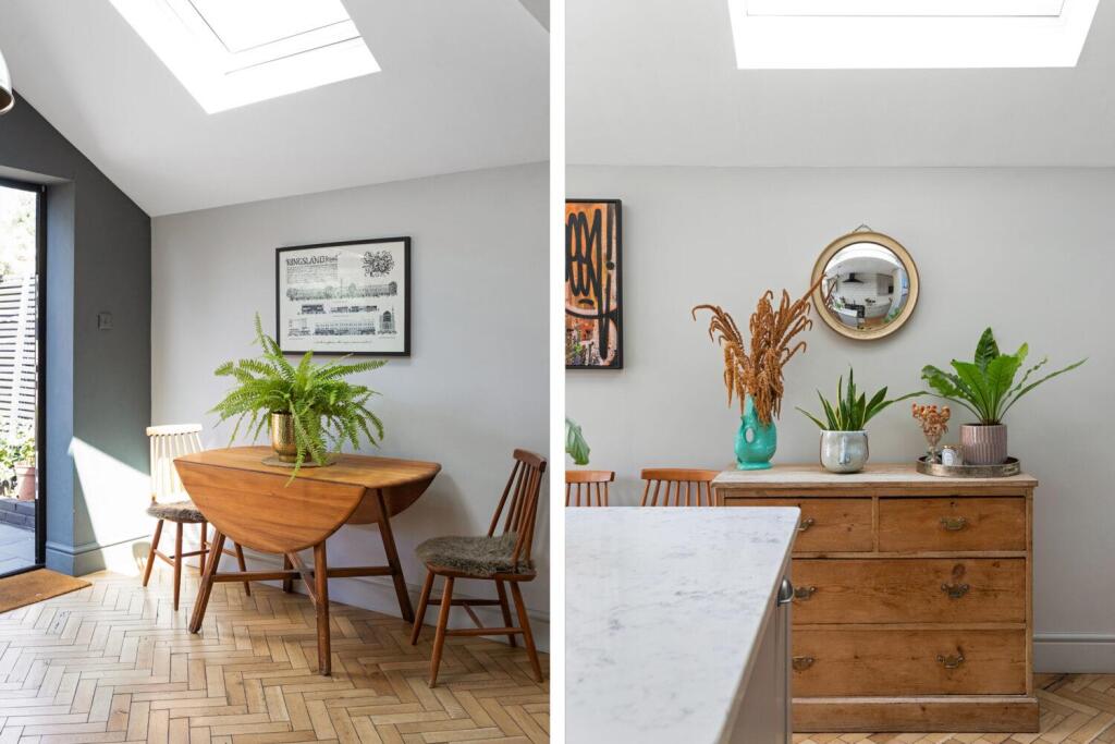
- Open Plan Kitchen / Reception Room:
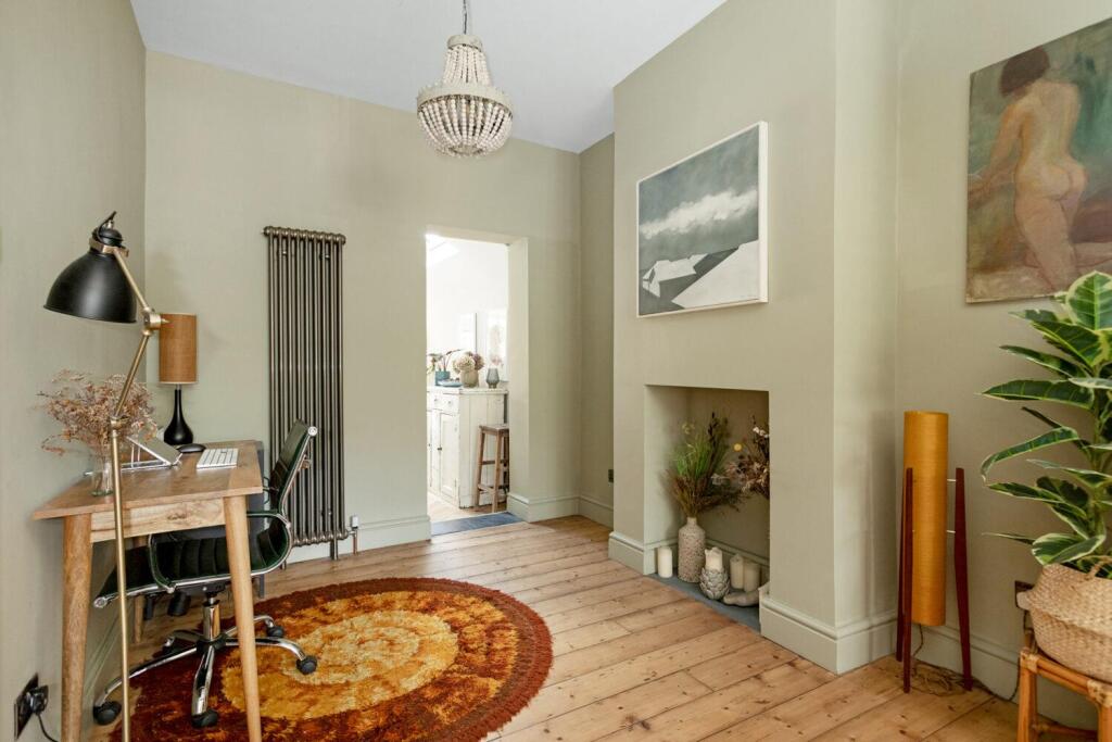
- Reception Room:
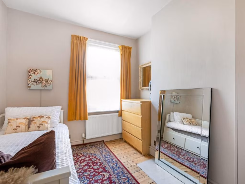
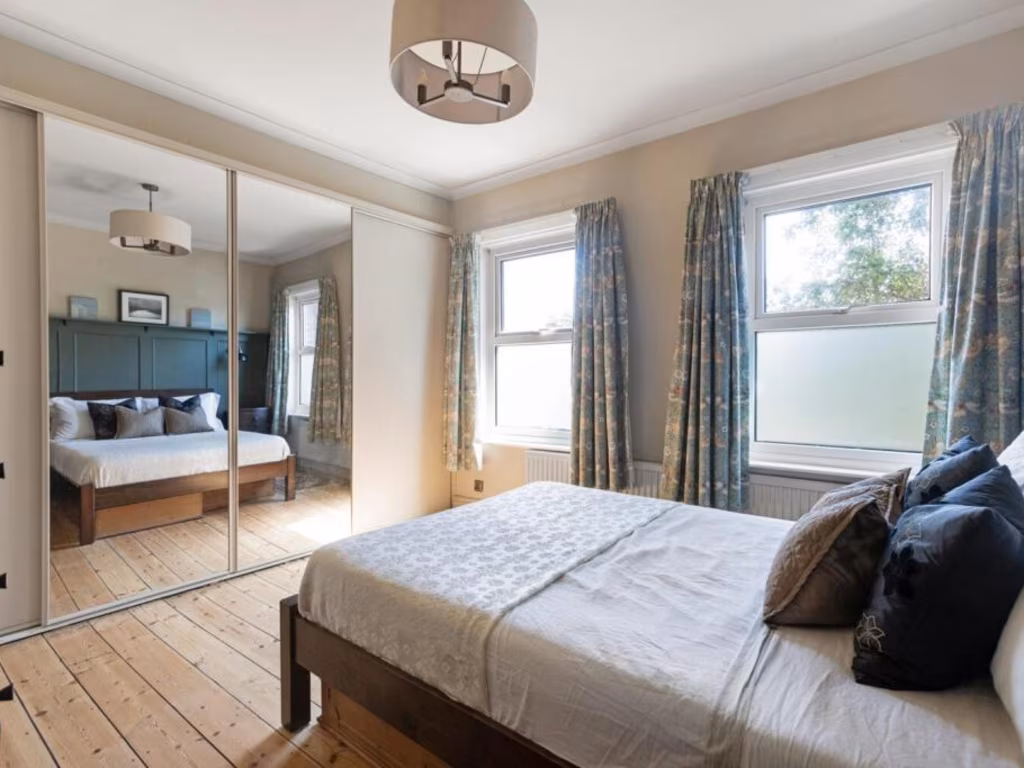
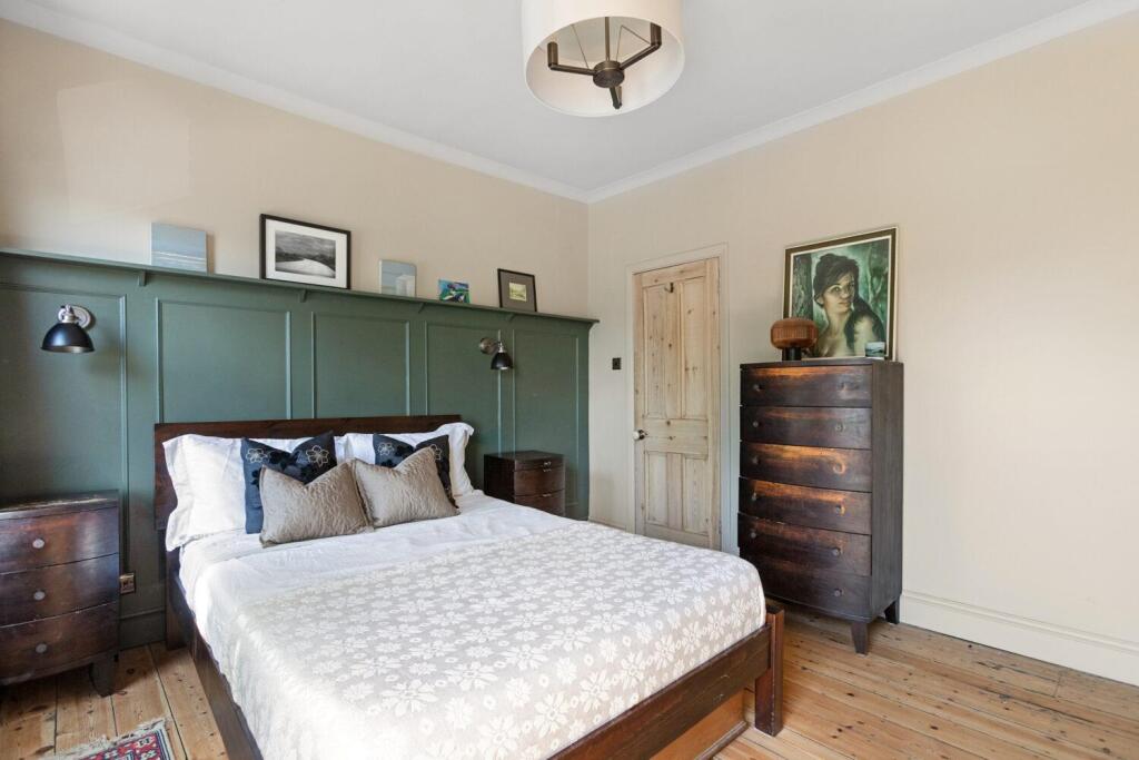
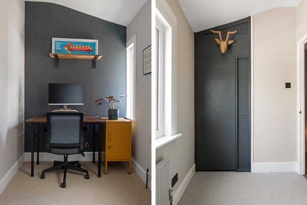
- Bedroom:
- Bedroom:
- Bedroom:
Textual Property Features
Detected Visual Features
- Victorian
- terrace house
- bay window
- brick exterior
- period features
- high ceiling
- residential
- urban
- traditional architecture
- living room
- high ceilings
- wooden floor
EPC Details
- Fully double glazed
- Solid brick, as built, no insulation (assumed)
- Boiler and radiators, mains gas
- Low energy lighting in 79% of fixed outlets
- Suspended, no insulation (assumed)
Nearby Schools
- Stewart Fleming Primary School
- Churchfields Primary School
- Balgowan Primary School
- Kings London
- Alexandra Junior School
- St Bartholomews's Church of England Primary School
- Kelvin Grove Primary School
- Sydenham School
- Perrymount Primary School
- Horniman Primary School
- Harris City Academy Crystal Palace
- Alexandra Infant School
- St John's Church of England Primary School
- Harris Girls Academy Bromley
- Harris Primary Academy Crystal Palace
- Sydenham High School, GDST
- Adamsrill Primary School
- Holy Trinity Church of England Primary School
- St Anthony's Roman Catholic Primary School
- James Dixon Primary School
- Haseltine Primary School
- St Mark's Church of England Primary Academy
- Harris Primary Academy Kent House
- Paxton Primary School
- Forest Hill School
- Eliot Bank Primary School
- St George's CofE Primary School
Nearest General Shops
- Id: 4219479113
- Tags:
- Addr:
- City: Penge
- Street: High Street
- Name: De Niros Barbers
- Shop: hairdresser
- TagsNormalized:
- Lat: 51.4176761
- Lon: -0.0583728
- FullGeoHash: gcpuw8m3xvd1
- PartitionGeoHash: gcpu
- Images:
- FoodStandards: null
- Distance: 182.1
,- Id: 4219479114
- Tags:
- Addr:
- City: Penge
- Street: High Street
- Name: Sen Thai Masage
- Shop: beauty
- TagsNormalized:
- Lat: 51.4176508
- Lon: -0.0582975
- FullGeoHash: gcpuw8m998f4
- PartitionGeoHash: gcpu
- Images:
- FoodStandards: null
- Distance: 182.1
,- Id: 4219488229
- Tags:
- Addr:
- City: Penge
- Street: Kingswood Road
- Name: SLR Autos
- Phone: +44 20 8778 5755
- Shop: car_repair
- TagsNormalized:
- Lat: 51.417741
- Lon: -0.0580788
- FullGeoHash: gcpuw8mdn9tk
- PartitionGeoHash: gcpu
- Images:
- FoodStandards: null
- Distance: 166.4
}
Nearest Grocery shops
- Id: 4221386319
- Tags:
- Addr:
- City: Penge
- Street: High Street
- Name: Jerry's
- Shop: convenience
- TagsNormalized:
- Lat: 51.4170677
- Lon: -0.0567414
- FullGeoHash: gcpuw8nwju4e
- PartitionGeoHash: gcpu
- Images:
- FoodStandards: null
- Distance: 227.3
,- Id: 290862247
- Tags:
- Addr:
- City: Penge
- Street: High Street
- Name: One Stop
- Opening_hours: 24/7
- Shop: convenience
- TagsNormalized:
- Lat: 51.4174655
- Lon: -0.0585441
- FullGeoHash: gcpuw8m27y62
- PartitionGeoHash: gcpu
- Images:
- FoodStandards: null
- Distance: 208.3
,- Id: 4219535608
- Tags:
- Addr:
- City: Penge
- Street: High Street
- Name: Kingswood Food & Wine
- Shop: convenience
- TagsNormalized:
- Lat: 51.4175104
- Lon: -0.0579346
- FullGeoHash: gcpuw8mbdn8u
- PartitionGeoHash: gcpu
- Images:
- FoodStandards: null
- Distance: 186.6
}
Nearest Supermarkets
- Id: 172844248
- Tags:
- Brand: ALDI
- Brand:wikidata: Q41171672
- Brand:wikipedia: en:Aldi
- Building: retail
- Contact:
- Website: https://stores.aldi.co.uk/anerley/97-croydon-road
- Name: ALDI
- Name:fa: آلدی
- Opening_hours: Mo-Sa 08:00-22:00; Su 10:00-16:00
- Shop: supermarket
- TagsNormalized:
- aldi
- retail
- supermarket
- shop
- Lat: 51.4084625
- Lon: -0.0590019
- FullGeoHash: gcpuqwt5cpuz
- PartitionGeoHash: gcpu
- Images:
- FoodStandards: null
- Distance: 1190.4
,- Id: 243583757
- Tags:
- Addr:
- City: London
- Housenumber: 106-112
- Postcode: SE26 5JX
- Street: Sydenham Road
- Brand: Lidl
- Brand:wikidata: Q151954
- Brand:wikipedia: en:Lidl
- Fhrs:
- Name: Lidl
- Name:fa: لیدل
- Operator: Lidl
- Shop: supermarket
- Source:
- Wheelchair: yes
- TagsNormalized:
- Lat: 51.4252759
- Lon: -0.04804
- FullGeoHash: gcpuwctjbw4z
- PartitionGeoHash: gcpu
- Images:
- FoodStandards:
- Id: 256273
- FHRSID: 256273
- LocalAuthorityBusinessID: PI/000150092
- BusinessName: Lidl
- BusinessType: Retailers - supermarkets/hypermarkets
- BusinessTypeID: 7840
- AddressLine1: 106-112 Sydenham Road
- AddressLine2: London
- AddressLine3: null
- AddressLine4: null
- PostCode: SE26 5JX
- RatingValue: 5
- RatingKey: fhrs_5_en-GB
- RatingDate: 2018-02-21
- LocalAuthorityCode: 523
- LocalAuthorityName: Lewisham
- LocalAuthorityWebSite: http://www.lewisham.gov.uk/myservices/business/food-safety/Pages/default.aspx
- LocalAuthorityEmailAddress: david.edwards@lewisham.gov.uk
- Scores:
- Hygiene: 5
- Structural: 5
- ConfidenceInManagement: 5
- NewRatingPending: false
- Geocode:
- Longitude: -0.04811870000000
- Latitude: 51.42521970000000
- Distance: 929.6
,- Id: 23945692
- Tags:
- Brand: Sainsbury's
- Brand:wikidata: Q152096
- Building: shop
- Name: Sainsbury's
- Shop: supermarket
- TagsNormalized:
- sainsburys
- shop
- supermarket
- Lat: 51.4126588
- Lon: -0.0515861
- FullGeoHash: gcpuqz6kmynx
- PartitionGeoHash: gcpu
- Images:
- FoodStandards: null
- Distance: 811.3
}
Nearest Religious buildings
- Id: 31181229
- Tags:
- Amenity: place_of_worship
- Building: yes
- Denomination: anglican
- Name: St John the Evangelist
- Religion: christian
- Wikidata: Q7588983
- TagsNormalized:
- place of worship
- anglican
- evangelist
- christian
- church
- Lat: 51.4166438
- Lon: -0.0549164
- FullGeoHash: gcpuwb058m57
- PartitionGeoHash: gcpu
- Images:
- FoodStandards: null
- Distance: 311.6
,- Id: 891006165
- Tags:
- Amenity: place_of_worship
- Building: yes
- Denomination: jehovahs_witness
- Name: Kingdom Hall of Jehovah's Witnesses
- Religion: christian
- TagsNormalized:
- place of worship
- jehovah
- jehovahs witness
- christian
- church
- Lat: 51.4199934
- Lon: -0.0537355
- FullGeoHash: gcpuwb8z5veb
- PartitionGeoHash: gcpu
- Images:
- FoodStandards: null
- Distance: 252.1
,- Id: 4219468292
- Tags:
- Addr:
- City: Penge
- Housenumber: 21
- Street: High Street
- Leisure: fitness_centre
- Name: Temple of Strength
- Phone: +44 7816 062658
- Website: https://templeofstrengthstudio.com/
- TagsNormalized:
- fitness
- fitness centre
- leisure
- temple
- Lat: 51.4178016
- Lon: -0.058822
- FullGeoHash: gcpuw8m4mkgj
- PartitionGeoHash: gcpu
- Images:
- FoodStandards: null
- Distance: 188.4
}
Nearest Medical buildings
- Id: 682516022
- Tags:
- Amenity: clinic
- Building: yes
- Healthcare: clinic
- Name: Oaks Park Medical Centre
- TagsNormalized:
- Lat: 51.4132266
- Lon: -0.0632831
- FullGeoHash: gcpuqx3zv2hd
- PartitionGeoHash: gcpu
- Images:
- FoodStandards: null
- Distance: 782.2
,- Id: 852141521
- Tags:
- Addr:
- City: Penge, London
- Housenumber: 17
- Postcode: SE20 7AJ
- Street: Green Lane
- Amenity: dentist
- Building: yes
- Healthcare: dentist
- Healthcare:speciality: dentistry
- Name: Green Lane Dental Centre
- TagsNormalized:
- dentist
- health
- healthcare
- dentistry
- dental
- Lat: 51.4148696
- Lon: -0.0499528
- FullGeoHash: gcpuqzg9k427
- PartitionGeoHash: gcpu
- Images:
- FoodStandards: null
- Distance: 682.3
,- Id: 1089879584
- Tags:
- Amenity: pharmacy
- Building: yes
- Dispensing: yes
- Healthcare: pharmacy
- Name: Macks Pharmacy
- TagsNormalized:
- Lat: 51.4145462
- Lon: -0.0518588
- FullGeoHash: gcpuqzdprw56
- PartitionGeoHash: gcpu
- Images:
- FoodStandards: null
- Distance: 622.5
,- Id: 1089879597
- Tags:
- Amenity: pharmacy
- Brand: Superdrug
- Brand:wikidata: Q7643261
- Building: yes
- Contact:
- Website: https://www.superdrug.com/store/penge
- Dispensing: yes
- Healthcare: pharmacy
- Name: Superdrug
- TagsNormalized:
- pharmacy
- superdrug
- health
- healthcare
- Lat: 51.4152799
- Lon: -0.0526705
- FullGeoHash: gcpuqzceswy5
- PartitionGeoHash: gcpu
- Images:
- FoodStandards: null
- Distance: 523.4
}
Nearest Airports
- Id: 260720166
- Tags:
- Aerodrome: international
- Aeroway: aerodrome
- Alt_name: Gatwick Airport
- Ele: 62
- Iata: LGW
- Icao: EGKK
- Internet_access: wlan
- Internet_access:fee: no
- Internet_access:ssid: Gatwick FREE Wi-Fi
- Name: London Gatwick Airport
- Operator: Gatwick Airport Limited
- Ref: LGW
- Website: https://www.gatwickairport.com/
- Wikidata: Q8703
- Wikipedia: en:Gatwick Airport
- TagsNormalized:
- airport
- international airport
- Lat: 51.1540917
- Lon: -0.1883773
- FullGeoHash: gcpg58qf4mzd
- PartitionGeoHash: gcpg
- Images:
- FoodStandards: null
- Distance: 30850
,- Id: 121158889
- Tags:
- Aerodrome: continental
- Aeroway: aerodrome
- Fhrs:
- Authority: City of London Corporation
- Iata: LCY
- Icao: EGLC
- Name: London City Airport
- Operator: London City Airport Limited
- Ref: LCY
- Website: https://www.londoncityairport.com/
- Wikidata: Q8982
- Wikipedia: en:London City Airport
- TagsNormalized:
- airport
- continental airport
- Lat: 51.5042658
- Lon: 0.0539987
- FullGeoHash: u10j10p64702
- PartitionGeoHash: u10j
- Images:
- FoodStandards: null
- Distance: 12202.3
,- Id: 14001268
- Tags:
- Access: yes
- Aerodrome: international
- Aerodrome:type: public
- Aeroway: aerodrome
- Alt_name: London Heathrow
- Alt_name_2: London Heathrow Airport
- Ele: 25
- Iata: LHR
- Icao: EGLL
- Int_name: Heathrow Airport
- Name: London Heathrow Airport
- Note: area still approx
- Old_name: London Airport
- Operator: Heathrow Airport Limited
- Rank_aci:
- Ref: LHR
- Short_name: Heathrow
- Type: multipolygon
- Website: https://www.heathrow.com/
- Wikidata: Q8691
- Wikipedia: en:Heathrow Airport
- TagsNormalized:
- airport
- international airport
- Lat: 51.4677522
- Lon: -0.4547736
- FullGeoHash: gcpsv9kv7h2h
- PartitionGeoHash: gcps
- Images:
- FoodStandards: null
- Distance: 28088.7
}
Nearest Leisure Facilities
- Id: 231330223
- Tags:
- Leisure: pitch
- Sport: tennis
- TagsNormalized:
- Lat: 51.4222127
- Lon: -0.0591306
- FullGeoHash: gcpuw9hun5jn
- PartitionGeoHash: gcpu
- Images:
- FoodStandards: null
- Distance: 374.1
,- Id: 231330230
- Tags:
- Leisure: pitch
- Sport: tennis
- TagsNormalized:
- Lat: 51.4221771
- Lon: -0.0589021
- FullGeoHash: gcpuw9j5gkx6
- PartitionGeoHash: gcpu
- Images:
- FoodStandards: null
- Distance: 364.7
,- Id: 231330227
- Tags:
- Leisure: pitch
- Sport: tennis
- TagsNormalized:
- Lat: 51.4218592
- Lon: -0.0594149
- FullGeoHash: gcpuw9hdp934
- PartitionGeoHash: gcpu
- Images:
- FoodStandards: null
- Distance: 346.9
,- Id: 231330225
- Tags:
- Leisure: pitch
- Sport: tennis
- TagsNormalized:
- Lat: 51.4218477
- Lon: -0.0591909
- FullGeoHash: gcpuw9hcuz0j
- PartitionGeoHash: gcpu
- Images:
- FoodStandards: null
- Distance: 338.8
,- Id: 376224321
- Tags:
- Leisure: pitch
- Lit: no
- Sport: soccer
- Surface: grass
- TagsNormalized:
- Lat: 51.4168958
- Lon: -0.0575831
- FullGeoHash: gcpuw8nj4hnf
- PartitionGeoHash: gcpu
- Images:
- FoodStandards: null
- Distance: 247.7
}
Nearest Tourist attractions
- Id: 5842530001
- Tags:
- Addr:
- City: Sydenham
- Housenumber: 140
- Postcode: SE26 5JZ
- Street: Sydenham Road
- Name: The Lovely Gallery
- Tourism: gallery
- TagsNormalized:
- Lat: 51.42558
- Lon: -0.0455646
- FullGeoHash: gcpuwcwzdqbt
- PartitionGeoHash: gcpu
- Images:
- FoodStandards: null
- Distance: 1075.3
,- Id: 670997038
- Tags:
- Dog: no
- Tourism: picnic_site
- TagsNormalized:
- Lat: 51.4194119
- Lon: -0.0661021
- FullGeoHash: gcpuw2xgg9ne
- PartitionGeoHash: gcpu
- Images:
- FoodStandards: null
- Distance: 626.7
,- Id: 672676426
- Tags:
- Operator: Brown & Green
- Tourism: picnic_site
- TagsNormalized:
- Lat: 51.4189368
- Lon: -0.0640505
- FullGeoHash: gcpuw8935883
- PartitionGeoHash: gcpu
- Images:
- FoodStandards: null
- Distance: 483.8
}
Nearest Hotels
- Id: 539644959
- Tags:
- Addr:
- City: London Borough of Bromley
- Housename: Bromley Court Hotel
- Postcode: BR1 4JD
- Street: Coniston Road
- Building: yes
- Fhrs:
- Name: Bromley Court Hotel
- Phone: +44 20 8461 8600
- Source:
- Tourism: hotel
- TagsNormalized:
- Lat: 51.4167004
- Lon: 0.0018655
- FullGeoHash: u10h8017grxh
- PartitionGeoHash: u10h
- Images:
- FoodStandards: null
- Distance: 4096.2
,- Id: 32349145
- Tags:
- Addr:
- City: London
- Housenumber: 122
- Postcode: SE19 2UG
- Street: Church Road
- Suburb: Upper Norwood
- Building: yes
- Building:levels: 1
- Fhrs:
- Authority: Croydon
- Id: 1867
- Name: Queens Hotel
- Phone: +44 20 8653 6622
- Tourism: hotel
- Website: www.euroqueenshotel.com
- TagsNormalized:
- Lat: 51.415216
- Lon: -0.0835473
- FullGeoHash: gcpuqpg5m4yw
- PartitionGeoHash: gcpu
- Images:
- FoodStandards: null
- Distance: 1885.7
,- Id: 1084648842
- Tags:
- Brand: Travelodge
- Brand:wikidata: Q9361374
- Building: yes
- Internet_access: wlan
- Internet_access:fee: customers
- Internet_access:ssid: Travelodge WiFi
- Name: Travelodge
- Tourism: hotel
- TagsNormalized:
- Lat: 51.4106898
- Lon: -0.0551484
- FullGeoHash: gcpuqxpbfznq
- PartitionGeoHash: gcpu
- Images:
- FoodStandards: null
- Distance: 944.8
}
Tags
- Victorian
- terrace house
- bay window
- brick exterior
- period features
- high ceiling
- residential
- urban
- traditional architecture
- Victorian
- living room
- high ceilings
- bay window
- wooden floor
- period features
Local Market Stats
- Average Price/sqft: £539
- Avg Income: £55500
- Rental Yield: 4.7%
- Social Housing: 29%
- Planning Success Rate: 71%
AirBnB Data
- 1km average: £98/night
- Listings in 1km: 16
Similar Properties
 3 bedroom terraced house for sale in Crampton Road, London, SE20 — £650,000 • 3 bed • 1 bath • 950 ft²
 5 bedroom semi-detached house for sale in Melvin Road, Penge, London, SE20 — £800,000 • 5 bed • 2 bath • 1863 ft²
 4 bedroom semi-detached house for sale in Montrave Road, Penge, London, SE20 — £950,000 • 4 bed • 2 bath • 1454 ft²
 3 bedroom house for sale in Provincial Terrace, Penge, London, SE20 — £500,000 • 3 bed • 1 bath • 888 ft²
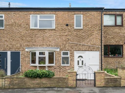 3 bedroom terraced house for sale in Bargrove Close, London, SE20 — £550,000 • 3 bed • 1 bath • 968 ft²
 3 bedroom terraced house for sale in Parish Lane, Penge, London, SE20 — £550,000 • 3 bed • 2 bath • 1051 ft²
Meta
- {
"@context": "https://schema.org",
"@type": "Residence",
"name": "3 bedroom terraced house for sale in Kingswood Road, Penge,…",
"description": "",
"url": "https://propertypiper.co.uk/property/798a866b-b039-43fb-9102-996e99762fd9",
"image": "https://image-a.propertypiper.co.uk/c7935711-6db2-4464-bd10-58555ecff176-1024.jpeg",
"address": {
"@type": "PostalAddress",
"streetAddress": "63 KINGSWOOD ROAD LONDON",
"postalCode": "SE20 7BL",
"addressLocality": "Bromley",
"addressRegion": "Lewisham West and Penge",
"addressCountry": "England"
},
"geo": {
"@type": "GeoCoordinates",
"latitude": 51.41910085121577,
"longitude": -0.05707810135552579
},
"numberOfRooms": 3,
"numberOfBathroomsTotal": 1,
"floorSize": {
"@type": "QuantitativeValue",
"value": 1185,
"unitCode": "FTK"
},
"offers": {
"@type": "Offer",
"price": 850000,
"priceCurrency": "GBP",
"availability": "https://schema.org/InStock"
},
"additionalProperty": [
{
"@type": "PropertyValue",
"name": "Feature",
"value": "Victorian"
},
{
"@type": "PropertyValue",
"name": "Feature",
"value": "terrace house"
},
{
"@type": "PropertyValue",
"name": "Feature",
"value": "bay window"
},
{
"@type": "PropertyValue",
"name": "Feature",
"value": "brick exterior"
},
{
"@type": "PropertyValue",
"name": "Feature",
"value": "period features"
},
{
"@type": "PropertyValue",
"name": "Feature",
"value": "high ceiling"
},
{
"@type": "PropertyValue",
"name": "Feature",
"value": "residential"
},
{
"@type": "PropertyValue",
"name": "Feature",
"value": "urban"
},
{
"@type": "PropertyValue",
"name": "Feature",
"value": "traditional architecture"
},
{
"@type": "PropertyValue",
"name": "Feature",
"value": "Victorian"
},
{
"@type": "PropertyValue",
"name": "Feature",
"value": "living room"
},
{
"@type": "PropertyValue",
"name": "Feature",
"value": "high ceilings"
},
{
"@type": "PropertyValue",
"name": "Feature",
"value": "bay window"
},
{
"@type": "PropertyValue",
"name": "Feature",
"value": "wooden floor"
},
{
"@type": "PropertyValue",
"name": "Feature",
"value": "period features"
}
]
}
High Res Floorplan Images
Compatible Floorplan Images
FloorplanImages Thumbnail