YO17 6UN - Land for sale in 8.21 acres of Land at Amotherby, Malton, Y…
View on Property Piper
Land for sale in 8.21 acres of Land at Amotherby, Malton, YO17
Property Details
- Price: £90000
- Bedrooms: 1
- Bathrooms: 1
- Property Type: undefined
- Property SubType: undefined
Brochure Descriptions
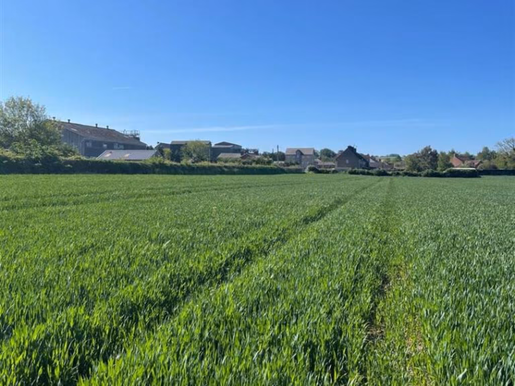
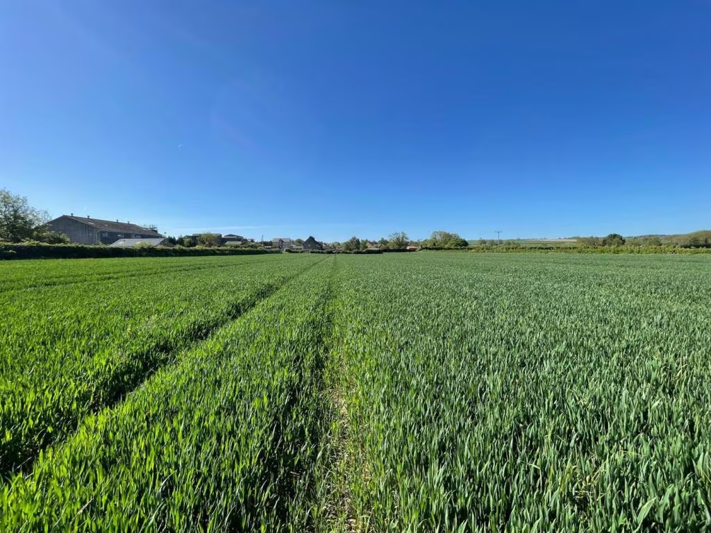
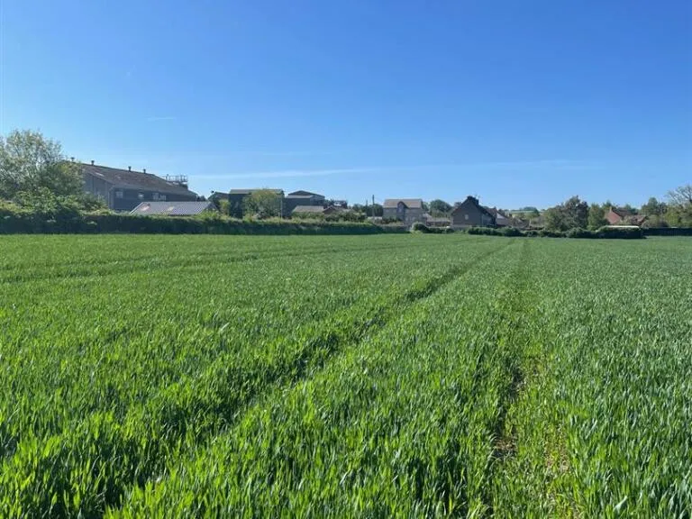
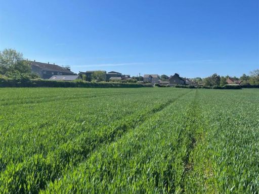
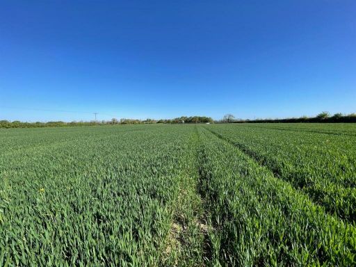
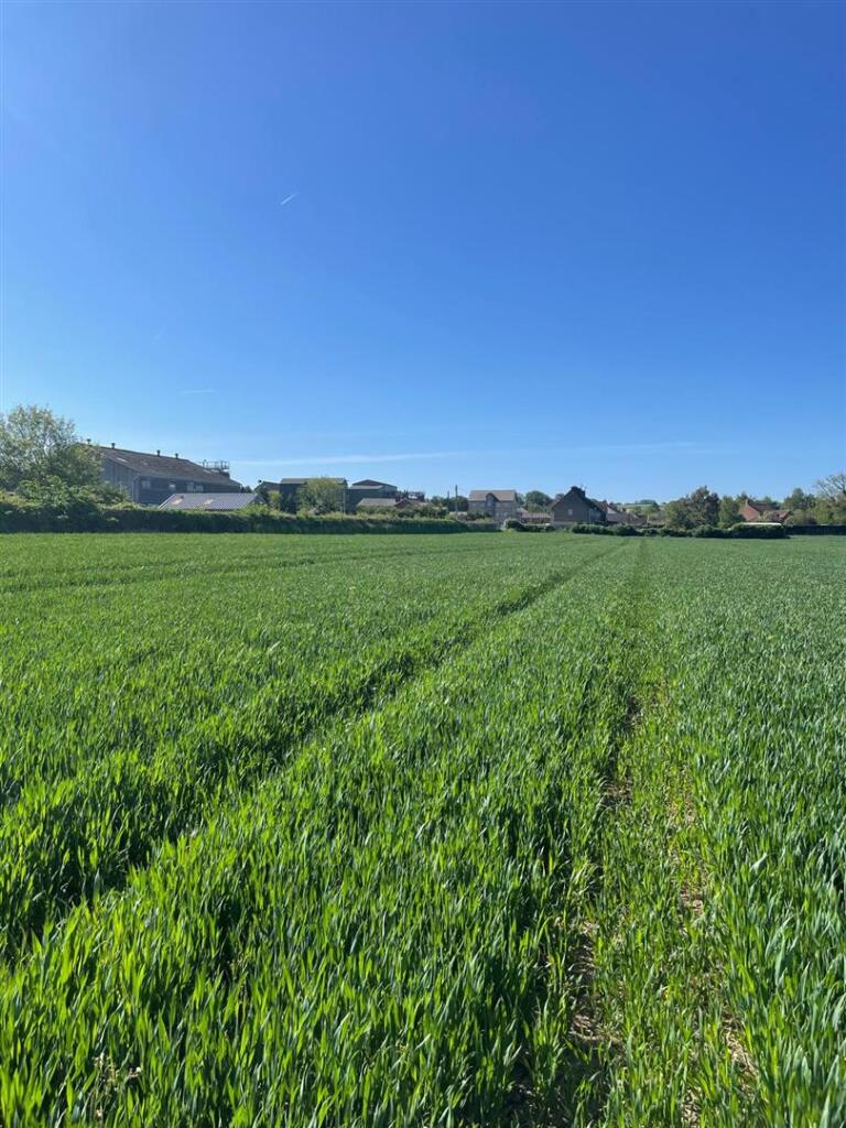
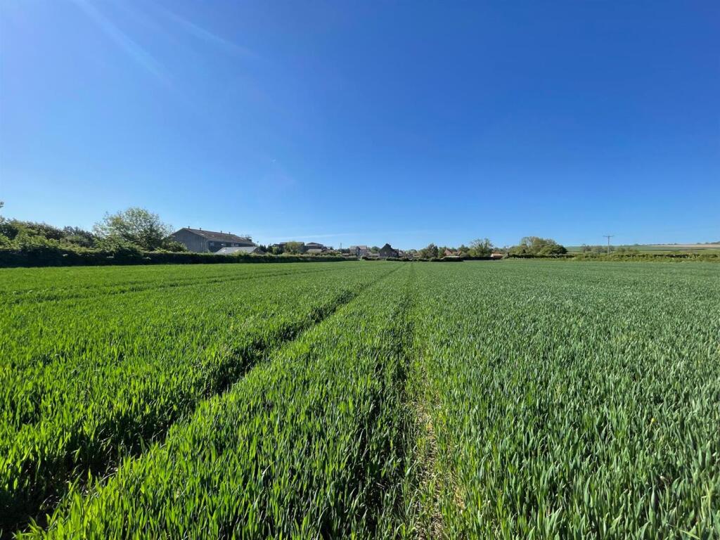
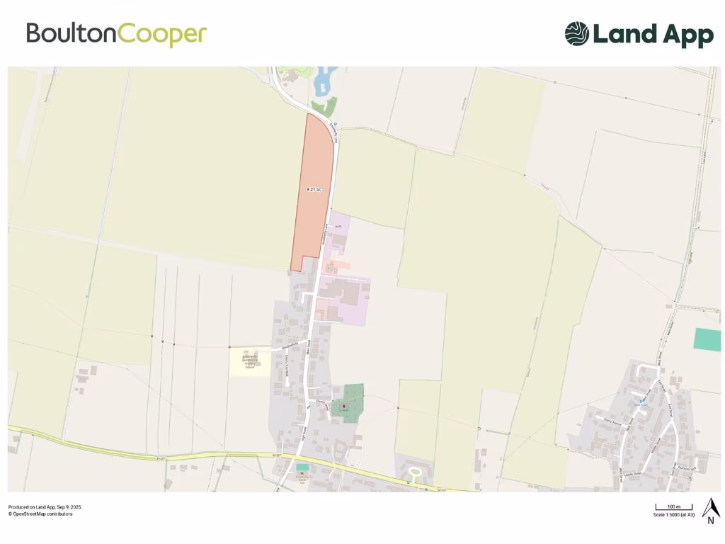
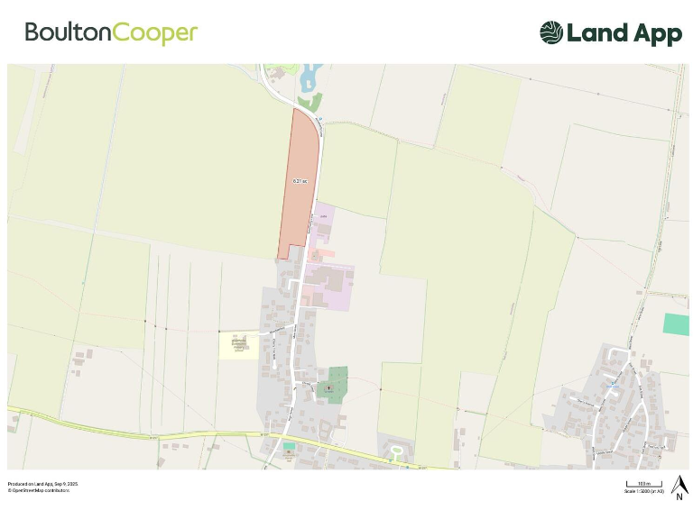
- A single, large parcel of productive agricultural land extending to approximately 8.21 acres (3.22 hectares). The plot has roadside frontage onto Amotherby Lane and is situated on the northern/edge of the village of Amotherby, Malton. The land is generally level with open rural/countryside views to the surrounding fields and village; suitable for agricultural, equestrian, horticultural or alternative uses subject to necessary planning consents. Parcel size: large field (8.21 acres).
- 8.21 acres of principally arable/amenity land located at Amotherby, near Malton. The parcel appears as a single, elongated/rectangular field immediately north of the village with direct access from the local road. The land is predominantly level to gently sloping, bounded by neighbouring agricultural fields and hedgerows, offering open rural views across surrounding farmland. Property size is large (approx. 8.21 acres) and is suited to agricultural use, grazing or other rural enterprises; any alternative uses (including development) would be subject to obtaining the necessary planning consents. Overall condition and boundaries appear typical for countryside land in the area; purchasers should obtain a full ground and title survey for precise boundaries, access rights and potential constraints.
Image Descriptions
- land
- agricultural land rural
Floorplan Description
- Land parcel highlighted as 8.21 acres.
Textual Property Features
Detected Visual Features
- land
- open field
- agricultural
- development potential
- green space
- investment opportunity
- expansive
- clear views
- rural
- field
- farm
- plot
- development
Nearby Schools
- Norton Community Primary School
- Malton Primary Academy
- Slingsby Community Primary School
- Amotherby Community Primary School
- Langton Primary School
- Norton College
- St Mary's Catholic Primary School - a Catholic voluntary academy
Nearest General Shops
- Id: 2406092809
- Tags:
- TagsNormalized:
- Lat: 54.1358717
- Lon: -0.7991316
- FullGeoHash: gcx7vz4h6cum
- PartitionGeoHash: gcx7
- Images:
- FoodStandards: null
- Distance: 4090
,- Id: 496691381
- Tags:
- Brand: vauxhall
- Name: J B Motors
- Shop: car
- TagsNormalized:
- Lat: 54.1373319
- Lon: -0.7987329
- FullGeoHash: gcx7vz6ku4je
- PartitionGeoHash: gcx7
- Images:
- FoodStandards: null
- Distance: 4028.3
,- Id: 496692644
- Tags:
- Name: Atkin Motor Engineers
- Shop: car
- TagsNormalized:
- Lat: 54.1487477
- Lon: -0.8378261
- FullGeoHash: gcxkhcmzm4pt
- PartitionGeoHash: gcxk
- Images:
- FoodStandards: null
- Distance: 1201.4
}
Nearest Grocery shops
- Id: 9949214160
- Tags:
- Name: Food 2 remember
- Shop: butcher
- TagsNormalized:
- Lat: 54.1345085
- Lon: -0.8006966
- FullGeoHash: gcx7vybuq7v3
- PartitionGeoHash: gcx7
- Images:
- FoodStandards: null
- Distance: 4088.6
,- Id: 461255363
- Tags:
- Brand: Sainsbury's Local
- Brand:wikidata: Q13218434
- Brand:wikipedia: en:Sainsbury's Local
- Building: yes
- Name: Sainsbury's Local
- Shop: convenience
- TagsNormalized:
- sainsburys
- sainsburys local
- convenience
- shop
- Lat: 54.1369892
- Lon: -0.7992214
- FullGeoHash: gcx7vz64bf1r
- PartitionGeoHash: gcx7
- Images:
- FoodStandards: null
- Distance: 4020.2
,- Id: 3902949100
- Tags:
- Name: Bentleys Village Shop
- Shop: convenience
- TagsNormalized:
- Lat: 54.1483543
- Lon: -0.8384859
- FullGeoHash: gcxkhcmmjbge
- PartitionGeoHash: gcxk
- Images:
- FoodStandards: null
- Distance: 1196.5
}
Nearest Religious buildings
- Id: 524358884
- Tags:
- Amenity: place_of_worship
- Building: yes
- Denomination: anglican
- Name: St Chad
- Religion: christian
- Wikidata: Q105106877
- TagsNormalized:
- place of worship
- anglican
- christian
- church
- Lat: 54.1766668
- Lon: -0.8390955
- FullGeoHash: gcxkhysczwtj
- PartitionGeoHash: gcxk
- Images:
- FoodStandards: null
- Distance: 2509.6
,- Id: 586404631
- Tags:
- Amenity: place_of_worship
- Building: church
- Denomination: anglican
- Name: All Saints
- Religion: christian
- Wikidata: Q17525633
- TagsNormalized:
- place of worship
- church
- anglican
- christian
- Lat: 54.1528186
- Lon: -0.8770843
- FullGeoHash: gcxkh41r43n9
- PartitionGeoHash: gcxk
- Images:
- FoodStandards: null
- Distance: 1641.3
,- Id: 852320921
- Tags:
- Amenity: place_of_worship
- Building: church
- Denomination: anglican
- Name: St Helen
- Religion: christian
- Wikidata: Q26442079
- TagsNormalized:
- place of worship
- church
- anglican
- christian
- Lat: 54.1512019
- Lon: -0.852166
- FullGeoHash: gcxkh9gmx5dv
- PartitionGeoHash: gcxk
- Images:
- FoodStandards: null
- Distance: 473.5
}
Nearest Medical buildings
- Id: 4175069839
- Tags:
- Addr:
- City: Malton
- Postcode: YO17 7HT
- Street: Wheelgate
- Amenity: pharmacy
- Brand: Boots
- Brand:wikidata: Q6123139
- Brand:wikipedia: en:Boots UK
- Dispensing: yes
- Healthcare: pharmacy
- Name: Boots
- TagsNormalized:
- pharmacy
- boots
- health
- healthcare
- Lat: 54.1358594
- Lon: -0.7973663
- FullGeoHash: gcx7vz5khp8s
- PartitionGeoHash: gcx7
- Images:
- FoodStandards: null
- Distance: 4188.5
,- Id: 4175067252
- Tags:
- Addr:
- City: Malton
- Postcode: YO17 7LX
- Street: Market Place
- Amenity: pharmacy
- Brand: Lloyds Pharmacy
- Brand:wikidata: Q6662870
- Brand:wikipedia: en:LloydsPharmacy
- Dispensing: yes
- Healthcare: pharmacy
- Name: Lloyds Pharmacy
- TagsNormalized:
- pharmacy
- lloyds pharmacy
- health
- healthcare
- Lat: 54.1351726
- Lon: -0.7986055
- FullGeoHash: gcx7vz42ppse
- PartitionGeoHash: gcx7
- Images:
- FoodStandards: null
- Distance: 4160.7
,- Id: 7474245275
- Tags:
- Addr:
- City: Malton
- Housenumber: 1
- Postcode: YO17 7JP
- Street: Princess Road
- Amenity: dentist
- Name: Dental Health Practice
- TagsNormalized:
- Lat: 54.1368903
- Lon: -0.7984435
- FullGeoHash: gcx7vz6d4zv3
- PartitionGeoHash: gcx7
- Images:
- FoodStandards: null
- Distance: 4069.4
,- Id: 662128709
- Tags:
- Addr:
- City: Malton
- Postcode: YO17 7NG
- Amenity: hospital
- Name: Malton Hospital
- TagsNormalized:
- Lat: 54.1371877
- Lon: -0.8063383
- FullGeoHash: gcx7vxkgfznx
- PartitionGeoHash: gcx7
- Images:
- FoodStandards: null
- Distance: 3617
}
Nearest Leisure Facilities
- Id: 441105627
- Tags:
- Leisure: pitch
- Sport: bowls
- TagsNormalized:
- Lat: 54.1473838
- Lon: -0.8406792
- FullGeoHash: gcxkhc5z6gbj
- PartitionGeoHash: gcxk
- Images:
- FoodStandards: null
- Distance: 1173.7
,- Id: 687147378
- Tags:
- TagsNormalized:
- Lat: 54.1657084
- Lon: -0.8557332
- FullGeoHash: gcxkhs8f5gzh
- PartitionGeoHash: gcxk
- Images:
- FoodStandards: null
- Distance: 1161.6
,- Id: 900686643
- Tags:
- Leisure: playground
- Surface: grass
- TagsNormalized:
- Lat: 54.1475784
- Lon: -0.841124
- FullGeoHash: gcxkhc7882hq
- PartitionGeoHash: gcxk
- Images:
- FoodStandards: null
- Distance: 1138.5
,- Id: 1087517343
- Tags:
- TagsNormalized:
- Lat: 54.1530152
- Lon: -0.835604
- FullGeoHash: gcxkhfr81j8q
- PartitionGeoHash: gcxk
- Images:
- FoodStandards: null
- Distance: 1119.7
,- Id: 1087517342
- Tags:
- Leisure: pitch
- Sport: soccer
- Surface: grass
- TagsNormalized:
- Lat: 54.1527131
- Lon: -0.8362272
- FullGeoHash: gcxkhfpn6mru
- PartitionGeoHash: gcxk
- Images:
- FoodStandards: null
- Distance: 1089.3
}
Nearest Tourist attractions
- Id: 9602742204
- Tags:
- Addr:
- City: Malton
- Housenumber: 36
- Postcode: YO17 7AB
- Street: Yorkersgate
- Name: Malton Museum
- Tourism: museum
- Website: https://www.maltonmuseum.co.uk/
- Wikidata: Q60753467
- Wikipedia: en:Malton Museum
- TagsNormalized:
- Lat: 54.1343509
- Lon: -0.7992261
- FullGeoHash: gcx7vyf52wmv
- PartitionGeoHash: gcx7
- Images:
- FoodStandards: null
- Distance: 4177.5
,- Id: 307853069
- Tags:
- Addr:
- City: Amotherby
- Postcode: YO17 6UP
- Name: Malton Grange Country Park
- Tourism: chalet
- TagsNormalized:
- Lat: 54.1656831
- Lon: -0.8551929
- FullGeoHash: gcxkhs93bx1v
- PartitionGeoHash: gcxk
- Images:
- FoodStandards: null
- Distance: 1152.5
,- Id: 307853077
- Tags:
- Addr:
- City: Amotherby
- Postcode: YO17 6UP
- Street: Amotherby Lane
- Name: Brickyard Lakes Country Park
- Tourism: caravan_site
- TagsNormalized:
- Lat: 54.1600634
- Lon: -0.8540155
- FullGeoHash: gcxkhed15zxf
- PartitionGeoHash: gcxk
- Images:
- FoodStandards: null
- Distance: 524.2
}
Nearest Train stations
- Id: 12709995
- Tags:
- Name: Newton Dale
- Public_transport: station
- Railway: station
- Usage: tourism
- Wikidata: Q7020211
- Wikipedia: en:Newton Dale Halt railway station
- TagsNormalized:
- Lat: 54.3424545
- Lon: -0.7177548
- FullGeoHash: gcxmpstrepep
- PartitionGeoHash: gcxm
- Images:
- FoodStandards: null
- Distance: 22555.1
,- Id: 8149349361
- Tags:
- Name: Kumali
- Public_transport: station
- Railway: station
- Usage: tourism
- TagsNormalized:
- Lat: 54.2111863
- Lon: -0.8068088
- FullGeoHash: gcxkmsu7pcxf
- PartitionGeoHash: gcxk
- Images:
- FoodStandards: null
- Distance: 6866.9
,- Id: 8149349362
- Tags:
- Name: Zoo
- Public_transport: station
- Railway: station
- Usage: tourism
- TagsNormalized:
- Lat: 54.2087968
- Lon: -0.8036184
- FullGeoHash: gcxkmsqv4k4s
- PartitionGeoHash: gcxk
- Images:
- FoodStandards: null
- Distance: 6723.4
,- Id: 8149349367
- Tags:
- Name: Plaza
- Public_transport: station
- Railway: station
- Usage: tourism
- TagsNormalized:
- Lat: 54.2094998
- Lon: -0.8078347
- FullGeoHash: gcxkmsec0p4y
- PartitionGeoHash: gcxk
- Images:
- FoodStandards: null
- Distance: 6668.9
,- Id: 7209217468
- Tags:
- Name: Malton
- Naptan:
- Network: National Rail
- Platforms: 1
- Public_transport: station
- Railway: station
- Ref:
- Source: npe
- Wikidata: Q2065298
- Wikipedia: en:Malton railway station
- TagsNormalized:
- Lat: 54.1318572
- Lon: -0.7977286
- FullGeoHash: gcx7vy7hgtd6
- PartitionGeoHash: gcx7
- Images:
- FoodStandards: null
- Distance: 4417.5
}
Nearest Bus stations and stops
- Id: 8149327575
- Tags:
- Bus: yes
- Highway: bus_stop
- Public_transport: platform
- TagsNormalized:
- Lat: 54.1322765
- Lon: -0.7863478
- FullGeoHash: gcx7yn7rkg8x
- PartitionGeoHash: gcx7
- Images:
- FoodStandards: null
- Distance: 5008.9
,- Id: 1815480421
- Tags:
- Bus: yes
- Highway: bus_stop
- Name: Old Malton School
- Naptan:
- AtcoCode: 32010056
- Bearing: S
- Public_transport: platform
- TagsNormalized:
- Lat: 54.1455215
- Lon: -0.7777403
- FullGeoHash: gcxkn2cst2fb
- PartitionGeoHash: gcxk
- Images:
- FoodStandards: null
- Distance: 4978.7
,- Id: 1815480438
- Tags:
- Bus: yes
- Highway: bus_stop
- Name: Old Malton School
- Naptan:
- AtcoCode: 32010013
- Bearing: N
- Public_transport: platform
- TagsNormalized:
- Lat: 54.1454666
- Lon: -0.7779656
- FullGeoHash: gcxkn2cs0ndc
- PartitionGeoHash: gcxk
- Images:
- FoodStandards: null
- Distance: 4965.7
,- Id: 8149327574
- Tags:
- Bus: yes
- Highway: bus_stop
- Public_transport: platform
- TagsNormalized:
- Lat: 54.1321859
- Lon: -0.7885765
- FullGeoHash: gcx7yn3ybffd
- PartitionGeoHash: gcx7
- Images:
- FoodStandards: null
- Distance: 4890.3
,- Id: 4321538661
- Tags:
- Bus: yes
- Highway: bus_stop
- Public_transport: platform
- Shelter: yes
- TagsNormalized:
- Lat: 54.1484974
- Lon: -0.8400186
- FullGeoHash: gcxkhckmf5s8
- PartitionGeoHash: gcxk
- Images:
- FoodStandards: null
- Distance: 1112.3
}
Nearest Hotels
- Id: 2053058548
- Tags:
- Addr:
- City: Malton
- Postcode: YO17 7EG
- Street: Old Maltongate
- Name: The Old Lodge
- Tourism: hotel
- TagsNormalized:
- Lat: 54.1355721
- Lon: -0.7929015
- FullGeoHash: gcx7vznds41f
- PartitionGeoHash: gcx7
- Images:
- FoodStandards: null
- Distance: 4455.2
,- Id: 280225734
- Tags:
- Addr:
- City: Malton
- Housenumber: 19
- Postcode: YO17 7AA
- Street: Yorkersgate
- Amenity: pub
- Name: George Hotel
- Opening_hours:
- TagsNormalized:
- Lat: 54.1343687
- Lon: -0.7979645
- FullGeoHash: gcx7vyfgw1dx
- PartitionGeoHash: gcx7
- Images:
- FoodStandards: null
- Distance: 4244.6
,- Id: 523637954
- Tags:
- Addr:
- City: Malton
- Housenumber: 43
- Postcode: YO17 7AJ
- Street: Yorkersgate
- Building: yes
- Name: The Talbot
- Note:
- Opening_hours:
- Covid19: View from road as of 06/12/2020
- Opening_hours:
- Source: Bing
- Tourism: hotel
- TagsNormalized:
- Lat: 54.1340082
- Lon: -0.8003208
- FullGeoHash: gcx7vyc1rnt9
- PartitionGeoHash: gcx7
- Images:
- FoodStandards: null
- Distance: 4140.5
}
Tags
- land
- open field
- agricultural
- development potential
- green space
- investment opportunity
- expansive
- clear views
- rural
- land
- agricultural
- rural
- field
- farm
- plot
- development
Local Market Stats
- Average Price/sqft: £257
- Avg Income: £40400
- Rental Yield: 4%
- Social Housing: 10%
- Planning Success Rate: 95%
Similar Properties
 4 bedroom detached house for sale in Ryton, Malton, North Yorkshire, YO17 — £1,250,000 • 4 bed • 3 bath • 3500 ft²
 6 bedroom detached house for sale in Main Street, Amotherby, Malton, YO17 — £1,250,000 • 6 bed • 5 bath • 3000 ft²
 Land for sale in Land Cartoft, Kirkbymoorside, YO62 6NX, YO62 — £150,000 • 1 bed • 1 bath
 Land for sale in Land at Claxton Village, York, YO60 7RX, YO60 — £100,000 • 1 bed • 1 bath
 3 bedroom semi-detached house for sale in Eastfield Estate, Amotherby, Malton, YO17 — £300,000 • 3 bed • 2 bath • 1350 ft²
 5 bedroom house for sale in Thornton Le Clay, York, YO60 — £2,200,000 • 5 bed • 2 bath • 2806 ft²
Meta
- {
"@context": "https://schema.org",
"@type": "Residence",
"name": "Land for sale in 8.21 acres of Land at Amotherby, Malton, Y…",
"description": "",
"url": "https://propertypiper.co.uk/property/71cfa24c-499b-45c6-8f33-9c70d6d699fc",
"image": "https://image-a.propertypiper.co.uk/c2a216eb-bd9f-46ce-855f-e30dc1c27f30-1024.jpeg",
"address": {
"@type": "PostalAddress",
"streetAddress": "8.21 acres of Land at Amotherby, Malton",
"postalCode": "YO17 6UN",
"addressLocality": "Ryedale",
"addressRegion": "Thirsk and Malton",
"addressCountry": "England"
},
"geo": {
"@type": "GeoCoordinates",
"latitude": 54.15545932535217,
"longitude": -0.8522846813823333
},
"numberOfRooms": 1,
"numberOfBathroomsTotal": 1,
"offers": {
"@type": "Offer",
"price": 90000,
"priceCurrency": "GBP",
"availability": "https://schema.org/InStock"
},
"additionalProperty": [
{
"@type": "PropertyValue",
"name": "Feature",
"value": "land"
},
{
"@type": "PropertyValue",
"name": "Feature",
"value": "open field"
},
{
"@type": "PropertyValue",
"name": "Feature",
"value": "agricultural"
},
{
"@type": "PropertyValue",
"name": "Feature",
"value": "development potential"
},
{
"@type": "PropertyValue",
"name": "Feature",
"value": "green space"
},
{
"@type": "PropertyValue",
"name": "Feature",
"value": "investment opportunity"
},
{
"@type": "PropertyValue",
"name": "Feature",
"value": "expansive"
},
{
"@type": "PropertyValue",
"name": "Feature",
"value": "clear views"
},
{
"@type": "PropertyValue",
"name": "Feature",
"value": "rural"
},
{
"@type": "PropertyValue",
"name": "Feature",
"value": "land"
},
{
"@type": "PropertyValue",
"name": "Feature",
"value": "agricultural"
},
{
"@type": "PropertyValue",
"name": "Feature",
"value": "rural"
},
{
"@type": "PropertyValue",
"name": "Feature",
"value": "field"
},
{
"@type": "PropertyValue",
"name": "Feature",
"value": "farm"
},
{
"@type": "PropertyValue",
"name": "Feature",
"value": "plot"
},
{
"@type": "PropertyValue",
"name": "Feature",
"value": "development"
}
]
}
High Res Floorplan Images
Compatible Floorplan Images
FloorplanImages Thumbnail